Showing 12 items matching "european waters"
-
 Lara RSL Sub Branch
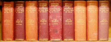
Book, Official History of Australia in the War of 1914-18 - Volume IX - The Royal Australian Navy Author A.W. Jose, 1937 fifth edition
... ...european waters...This volume of the War Histories is concerned with the doings of an infant navy. german colonies samoa nauru western pacific africa dardenelles north atlantic european waters raiders and minefields ran brigade hospital ships transports and dockyards radio-telegraphy suvla bay sinking of the cumberland german cruiser squadron cocos sydney-emden action north sea Official History of Australia in the War of 1914-18 - Volume IX - The Royal Australian Navy Maps and Illustrations Official History of Australia in the War of 1914-18 - Volume IX - The Royal Australian Navy Author A.W. ...Historically depicts the operations of the Royal Australian Navy duty occasioning navy vessels in addition to the drudgery of patrol work and the search for enemy vessels. Working in isolation because of being a vessel that is under their own control.This volume of the War Histories is concerned with the doings of an infant navy.Official History of Australia in the War of 1914-18 - Volume IX - The Royal Australian Navy Maps and Illustrationsgerman colonies, samoa, nauru, western pacific, africa, dardenelles, north atlantic, european waters, raiders and minefields, ran brigade, hospital ships, transports and dockyards, radio-telegraphy, suvla bay, sinking of the cumberland, german cruiser squadron, cocos, sydney-emden action, north sea -
 National Wool Museum
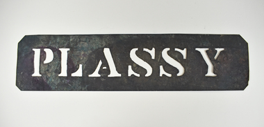
Stencil - PLASSY
... During WWI the Plassy was converted into a Grand Fleet hospital ship serving in European waters. All wool bales stamped with PLASSY would be transported on the Plassy ship....During WWI the Plassy was converted into a Grand Fleet hospital ship serving in European waters. All wool bales stamped with PLASSY would be transported on the Plassy ship. wool transportation wool export wool sales PLASSY Wool bale export stencil - PLASSY Stencil - PLASSY ...This stencil was used as a ship identifier stamp for the transportation of wool bales. Plassy was a troopship in the Boer and then the Indian Garrison rotation run. During WWI the Plassy was converted into a Grand Fleet hospital ship serving in European waters. All wool bales stamped with PLASSY would be transported on the Plassy ship.Wool bale export stencil - PLASSYPLASSYwool transportation, wool export, wool sales -
 Mission to Seafarers Victoria
Photograph - Photograph, Black and white, 1918
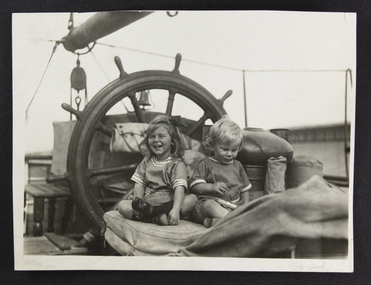
... The LHLG newsletter of 1918 features this image and notes that they accompanied their shipmaster father Captain Aviss, of the Barque Inverneill who with his wife Catherine Florence Aviss, travelling through dangerous European waters, brought the family of three children to visit Melbourne. ...Mission to Seafarers Victoria 717 Flinders Street Docklands melbourne The LHLG newsletter of 1918 features this image and notes that they accompanied their shipmaster father Captain Aviss, of the Barque Inverneill who with his wife Catherine Florence Aviss, travelling through dangerous European waters, brought the family of three children to visit Melbourne. ...The LHLG newsletter of 1918 features this image and notes that they accompanied their shipmaster father Captain Aviss, of the Barque Inverneill who with his wife Catherine Florence Aviss, travelling through dangerous European waters, brought the family of three children to visit Melbourne. The two children featured are Margaret and Ronald, born at sea in 1915. Their young sister, Ruth Neil, was also born at sea on the 27 August 1918. The family re-united with a first meeting for the children and grandparents, Captain and Mrs Frampton, who "had lost two ships to enemy submarines and were now on their third". The family participated in "a happy Communion service in our chapel , in which the parents and grandparents joined this formed the keystone of their visit to Melbourne". Unfortunately the young Mrs Aviss contracted the Spanish influenza on their arrival in St John, New Brunswick, Canada, she succumbed in November 1918 after spending a week in the Parks Hospital. Herbert Aviss was left with 2 toddlers and a 3 month old baby. He went back to England with his children in March 1919 on passenger ship, accompanied by a nurse. Martin Frampton and his wife were in New York at the time, but they probably learnt about Catherine's death in the local newspaper. A memorial plaque in her name unveiled in the chapel at the Mission in April 1919. The parents and grandparents left their names and signatures in the visitor book (0149) on the 28 April 1918.One of the rare stories of seafarer visits illustrated with a photograph of the children of a family accustomed to life aboard ship. The impact of influenza also affected this family and others are recorded amongst the supporters of the Mission and reflects the widespread impact that the epidemic of the post WW1 period had on people, Mission activities and restrictions affecting public events. Both Framptons and Aviss are noted in the annals of the Cape Horne society.Small monochrome photograph of two small children, a girl and a boy posed in front of the ship's wheel of a sailing vesselshipboard life, seafarer families, martin frampton, elizabeth frampton, herbert aviss, children, catherine florence aviss nee frampton, wwi, world war one, great war, first world war, german, submarine, u boat, torpedo, spanish influenza, flu, pandemic, st john, new brunswick, sea mites, wheel, boy, girl, margaret aviss, ronald aviss, ruth aviss, ruth neill aviss, ruth neill paterson nee aviss (1918-2017), ronald aviss (1915-1996) -
 Flagstaff Hill Maritime Museum and Village
Document - Poster, Warrnambool Steam Navigation Co, ca.1938
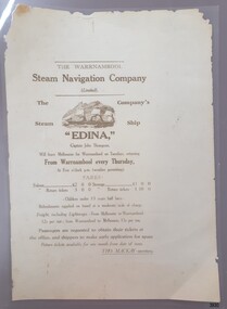
... The Edina also traded in UK and European waters. The Henty family of Portland, Victoria, purchased Edina in 1863 for use as a coastal trader. ...The Edina also traded in UK and European waters. The Henty family of Portland, Victoria, purchased Edina in 1863 for use as a coastal trader. ...This poster is typical of posters displayed by steam packet companies of the mid-19th to early 20th centuries. It advertises the passage and freight available on a local coastal trader. The steamships operated between the major ports along the western coast of Victoria between Melbourne and Portland. The traveller was not guaranteed the passage times due to possible weather changes. Discounts were offered for return trips within a month of the ticket's issue. The price of freight included 'lighterage', which was the service of a smaller vessel called a 'lighter' expressly designed to transport goods between ship and shore. This particular poster has been recreated; it advertises the services of the screw steamer SS Edina. The information on the poster applies to the years between 1871 and 1873. During that period the Master of the Edina was Captain John Thompson, the Edina was owned by the Warrnambool Steam Navigation Company and the secretary of the firm was Thos. Mackay. The passenger fares are in line with fares from that period, as seen in a display advertisement published in the Hamilton Spectator on January 17th, 1872. The 1853 Glasgow-built Screw Ship Edina had a long life. The ship served in both the Crimean War and the American Civil War. The Edina also traded in UK and European waters. The Henty family of Portland, Victoria, purchased Edina in 1863 for use as a coastal trader. The Edina had several owners and spent many years of service along the South West Coast of Victoria between Melbourne and Portland. The vessel transported passengers and freight in Port Phillip Bay, between Melbourne and Geelong, between 1880 and 1938. After 84 years of service, the Edina was renamed ‘Dinah’ and was stripped down for use as a lighter. The vessel was broken up in 1957 at Footscray, Melbourne. The remains of Edina’s hull can be found in the Maribyrnong River, Port Phillip Bay. The poster was owned by the donor's grandfather, Bruce Duff (1922-2003) who was an avid sailor and a lover of nautical history. He and his wife Mona (1924-2014) were buried in Portarlington Cemetery, Victoria. Duff would have been about 13 years old when the Edina was finally retired from service in 1938. His interest in the Edina could have come from a trip on the vessel or from watching it in operation in the ports along the coast. Duff has collected this poster as a memento of the Edina and is likely to have preserved it at a much later date when the lamination process was readily available. [Flagstaff Hill's collection includes a photograph of the Edina at the Moorabool Street Wharf, Geelong, which was in Duff's locality. The References for this poster include a link to Museum Victoria's photograph of two boys watching the Edina from a jetty.] Flagstaff Hill's Village has its own 'Examiner' Office where volunteers demonstrate the historic printing press in that building. They use original letter-type to create posters, print labels onto lolly bags and designs on fabrics. One of the volunteer printers has produced a poster closely resembling the donated poster. His replication includes a woodcut of the ship, which he skilfully crafted himself.This poster advertises the sailing of the steamer SS Edina and the information has local and State significance for its association with the trading ports of the Edina, and the associated names on the poster; Warrnambool Steam Navigation Company, Captain John Thompson and Thos. Mackay. This poster's message has a strong connection to the history of the businesses and community of Warrnambool and the people of Port Phillip Bay, where it was a passenger ferry for many years. The poster is an example of advertising used by shipping agents in the mid-19th to early 20th centuries. Its information includes the accurate costs to passengers and freighters and the type of timetable the vessels were likely to follow. The poster's connection with the Screw Steamship Edina is historically significant, as the vessel was the longest serving screw steamer in the world. The ship spent its first nine years overseas then arrived in Melbourne. The vessel's work included running the essential service of transporting cargo and passengers between Melbourne and the western Victoria ports of Warrnambool, Port Fairy and Portland. The Edina is listed on the Victorian Heritage Database VHR S199. Poster, A3 size, brown text on cream paper, laminated. Re-created poster of the Warrnambool Steam Navigation Company (Limited) advertising passage and freight on its Screw Steamship, SS Edina. It states days, times and fees for passage and freight from Warrnambool to Melbourne, and return. It names the ship's Master, Captain John Thompson and the Company's Secretary, Tho. Mackay. It displays a line drawing of a 3-masted ship with full sails.Printed image [side profile of a 3 masted vessel, bow facing left] Printed text includes "The Warrnambool Steam Navigation Company (Limited). The Company's Steam Ship "EDINA", Captain John Thompson, Will leave Melbourne for Warrnambool on Tuesdays, returning from Warrnambool every Thursday, At Five o'clock p.m. (weather permitting). FARES: Saloon £2 0 0 Steerage £1 0 0 Saloon return £3 0 0 Saloon return £1 10 00 - Children under 13 years half fares - Refreshments supplied onboard at a moderate scale of charge. Freight, including lighterage, - From Melbourne to Warrnambool - 12s per ton; from Warrnambool to Melbourne, 15s per ton. Passengers are requested to obtain their tickets at the offers, and shippers to make early application for space. Return tickets available for one month from date of issue. - THO. MACKAY, secretary. "warrnambool, shipwreck coast, flagstaff hill, flagstaff hill maritime museum, maritime museum, fair maid of judea, steam navigation, pleasure steamer, ss edina a, trade 19th century, travel 19th century, warrnambool to melbourne, warrnambool to geelong, warrnambool to port fairy, warrnambool to portland, screw steamer, coastal trader, crimean war, american civil war, gold export, h r h duke of edinburgh, warrnambool steam packet company, stephen henty, captain john thompson, chief engineer john davies, lady bay, lighter edina, port phillip bay steamers, vhr s199, dinah, warrnambool steam navigation company, advertising poster, shipping agent, flier, maritime village, flagstaff hill maritime museum & village, great ocean road, block printing, woodblock printing, relief printing, moorabool st wharf, western steam navigation company, tho. mackay, re-created poster -
 Flagstaff Hill Maritime Museum and Village
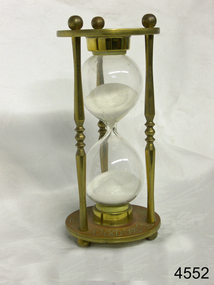
Instrument - Hourglass
... DEAD RECKONING (or Deduced Reckoning) Dead reckoning is the term used to describe the method of calculating the ship’s position from its speed and direction, used in early maritime travel, mostly in European waters. Both the (1) speed and the (2) direction of travel were recorded on a Traverse Board at half-hourly intervals during a helmsman’s watch of 4 hours. ...DEAD RECKONING (or Deduced Reckoning) Dead reckoning is the term used to describe the method of calculating the ship’s position from its speed and direction, used in early maritime travel, mostly in European waters. Both the (1) speed and the (2) direction of travel were recorded on a Traverse Board at half-hourly intervals during a helmsman’s watch of 4 hours. ...An hourglass or sandglass is an instrument for measuring a defined time and can be used perpetually by simply turning it over immediately the top bulb empties. The clear blown glass is shaped into two equal sized bulbs with a narrow passage in the centre and contains uniform sized sand or glass particles in the lower bulb. The width of the neck regulates the constant flow of the particles. The glass is held in a stand with top and bottom of equal shape and size. Hourglasses can measure an infinite variety of time by gauging the size of the particles, the shape and size of the bulbs and the size of the passage between the bulbs, thus measuring hours or minutes or even seconds. Generally an hourglass sits between discs of wood at the ends, which are joined by long wooden spindles between the ends and tightened by screw caps. The length of time can be adjusted by adding or removing sand particles. The use of the marine sandglass (or hourglass) has been recorded in the 14th century in European shipping. A one minute sandglass was used in conjunction with the ship’s log for ‘dead reckoning’, (see below) that is, for measuring the ship’s speed through the water. They were also used to regulate ringing the ship’s timetable; for example a 4 hour sandglass was used for the length of the sailors’ watch, and a half hour timer for taking of readings for the ship’s log; the ship’s bell would be rung every half hour. It was usually the role of the cabin boy to watch and turn the sandglasses over at the exact time of them emptying their upper chambers and to ring the ship’s bell. Hourglasses have been used historically for many hundreds of years. Some have been used for timing church sermons, in cooking, in industry and at sea. Even today they are used for measuring the cooking time of eggs and timing a player’s turn in games such as Boggle and Pictionary. The sandglasses at sea were gradually replaced in the late 1700’s to early 1800’s by the more accurate chronometers (marine clocks) when they became reliable instruments. DEAD RECKONING (or Deduced Reckoning) Dead reckoning is the term used to describe the method of calculating the ship’s position from its speed and direction, used in early maritime travel, mostly in European waters. Both the (1) speed and the (2) direction of travel were recorded on a Traverse Board at half-hourly intervals during a helmsman’s watch of 4 hours. The navigator would record the readings in his ship’s log, plot them on his navigational chart and give his updated course directions to the next helmsman on watch, along with the cleared Traverse Board. This was a very approximate, but none-the-less helpful, method of navigation. The wooden Traverse Board was a simple pegboard with a diagram of a compass with eight peg holes along the radius to each of the compass points, plus a grid with ascending half hours in the left column and increasing ship’s speed in knots in a row across the column headings, with a peg hole in each of the intersecting cells. A number of wooden pegs were attached to strings on the board. By placing one peg consecutively in the direction’s radius hole, starting from the centre, and the speed holes when the half hourly reading was taken, a picture of speed and direction for the whole 4 hour watch was created. (1) To measure the ship’s speed a one minute hourglass timer was usually used to measure the ship’s speed through the water and help to calculate its longitude. A rope, with knots at regular standard intervals and a weight such as a log at the end, would be thrown overboard at the stern of the ship. At the same time the hourglass would be turned over and a seaman would start counting the number of knots on the rope that passed freely through his hands as the ship travelled. When the timer ran out the counting would be stopped. A timer of one minute (one-sixtieth of an hour), knots spaced one-sixtieth of a nautical mile apart, and simple arithmetic easily gave the speed of the ship in nautical miles per hour ("knots"). This would be recorded every half hour. The speed could however be inaccurate to the travel being affected by ocean currents and wind. (2) To calculate the ship’s direction a compass sighting would be recorded each half hour.Marine hourglasses or sandglasses were used from around the 14th to 19th century during the time of sailing ships. This hourglass is representative of that era, which is during the time of the colonisation of Australia. Hourglass or sandglass; an instrument used to measure time. Two equal sized clear glass bulbs joined with a narrow passage between them, containing equal sized particles of sand grains in lower bulb. Glass sits in a brass collar at each end, in a frame comprising 3 decorative brass columns or posts, each attached top and bottom, using round screw-on feet, to round brass discs. Disc have Roman numerals for the numbers 1 - 12 pressed into their inner surfaces and hieroglyphics on the outer surfaces. Roman numerals on inner surface of discs " I II III IV V VI VII VIII IX X XI XII " Hieroglyphics impressed on outer surface of discsflagstaff hill, warrnambool, shipwrecked coast, flagstaff hill maritime museum, maritime museum, shipwreck coast, flagstaff hill maritime village, great ocean road, horology, hourglass, hour glass, sandglass, sand glass, timing instrument, dead reckoning, deduced reckoning, finding latitude at sea, sandglass with hieroglyphics and roman numerals, hourglass with hieroglyphics and roman numerals, brass hourglass -
 Eltham District Historical Society Inc
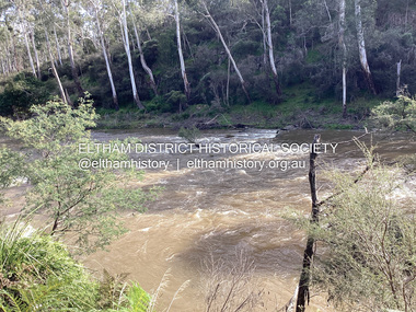
Photograph, Fay Bridge, Ancient Eel trap on the Yarra River at Laughing Waters, Eltham - pre-dating European settlement, 6 September 2023
... waters” in the traditional language, Woi wurrung. The site at Warrandyte was rediscovered by Campbell Beardsell OAM in 2007 and is one of only a few known remaining iuk (eel) traps on Country once found the length of the Birrarung (Yarra) and the Maribyrnong. Original Indigenous aquacultural infrastructure was dismantled, taken away from sites and used to build houses, fords and roads by Europeans...waters” in the traditional language, Woi wurrung. The site at Warrandyte was rediscovered by Campbell Beardsell OAM in 2007 and is one of only a few known remaining iuk (eel) traps on Country once found the length of the Birrarung (Yarra) and the Maribyrnong. Original Indigenous aquacultural infrastructure was dismantled, taken away from sites and used to build houses, fords and roads by Europeans ...Laughing Waters is the name for a stretch of the Yarra Valley Parklands consisting of river flats and hilly riparian bushland. With Birrarung (Yarra River) flowing through, Laughing Waters has been an important gathering place for thousands of years. For the Wurundjeri, ‘Garambi Baan’ (the name for Laughing Waters in Woi wurrung) is an important site for growing and harvesting food. Significantly, Wurundjeri iuk (eel) traps remain at Garambi Baan to this day. The Wurundjeri Woi Wurrung People take their name from the Woi wurrung language word ‘wurun’ meaning the Manna Gum (Eucalyptus viminalis) which is common along ‘Birrarung’ (Yarra River), and ‘djeri’, the grub which is found in or near the tree. Wurundjeri are the ‘Manna Gum People’ and their Ancestors have lived on this land for millennia. The site on the Yarra River near the former Morrison property Killeavey was given a language name in 2015 at the instigation of Wurundjeri Elder, Dave Wandin. Garambi Baan means “laughing waters” in the traditional language, Woi wurrung. The site at Warrandyte was rediscovered by Campbell Beardsell OAM in 2007 and is one of only a few known remaining iuk (eel) traps on Country once found the length of the Birrarung (Yarra) and the Maribyrnong. Original Indigenous aquacultural infrastructure was dismantled, taken away from sites and used to build houses, fords and roads by Europeans. The difficult and restricted access to this site is thought to be one of the reasons for its survival. The iuk trap is located within lands managed by Parks Victoria. The Narrap team in partnership with Parks Victoria and Acacia Land Management have been improving the native vegetation with a program of woody weed removal, exclusion fencing and revegetation. Importantly, the team have restored the trap’s infrastructure and have demonstrated its effectiveness.” References: Wurundjeri Woi Wurrung Cultural Heritage Aboriginal Corporation - Laughing Waters. (2023, September 3). Retrieved from https://inplace.org.au/laughing-waters/ GARAMBI BAAN LAUGHING WATERS RESIDENCY CENTRE 2020 2024 Strategic Plan, Nillumbik Shire Council (2023, September 3). Retrieved from https://www.nillumbik.vic.gov.au/files/assets/public/minutes-and-agendas/2020/09-sep/15-sep-cm/ocm.177-20-attachment-1-laughing-waters-arts-program_1.pdffay bridge collection, eel trap, laughing waters, yarra river, wurundjeri woi wurrung, garambi baan, 2023-09-06 -
 Eltham District Historical Society Inc
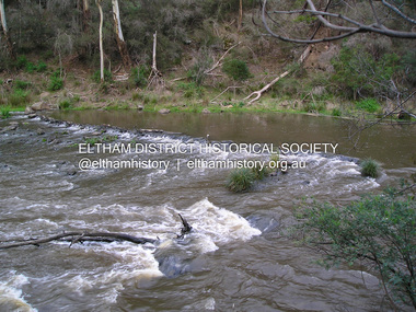
Photograph, Fay Bridge, Ancient Eel trap on the Yarra River at Laughing Waters, Eltham - pre-dating European settlement, 16 May 2015
... waters” in the traditional language, Woi wurrung. The site at Warrandyte was rediscovered by Campbell Beardsell OAM in 2007 and is one of only a few known remaining iuk (eel) traps on Country once found the length of the Birrarung (Yarra) and the Maribyrnong. Original Indigenous aquacultural infrastructure was dismantled, taken away from sites and used to build houses, fords and roads by Europeans...waters” in the traditional language, Woi wurrung. The site at Warrandyte was rediscovered by Campbell Beardsell OAM in 2007 and is one of only a few known remaining iuk (eel) traps on Country once found the length of the Birrarung (Yarra) and the Maribyrnong. Original Indigenous aquacultural infrastructure was dismantled, taken away from sites and used to build houses, fords and roads by Europeans ...Laughing Waters is the name for a stretch of the Yarra Valley Parklands consisting of river flats and hilly riparian bushland. With Birrarung (Yarra River) flowing through, Laughing Waters has been an important gathering place for thousands of years. For the Wurundjeri, ‘Garambi Baan’ (the name for Laughing Waters in Woi wurrung) is an important site for growing and harvesting food. Significantly, Wurundjeri iuk (eel) traps remain at Garambi Baan to this day. The Wurundjeri Woi Wurrung People take their name from the Woi wurrung language word ‘wurun’ meaning the Manna Gum (Eucalyptus viminalis) which is common along ‘Birrarung’ (Yarra River), and ‘djeri’, the grub which is found in or near the tree. Wurundjeri are the ‘Manna Gum People’ and their Ancestors have lived on this land for millennia. The site on the Yarra River near the former Morrison property Killeavey was given a language name in 2015 at the instigation of Wurundjeri Elder, Dave Wandin. Garambi Baan means “laughing waters” in the traditional language, Woi wurrung. The site at Warrandyte was rediscovered by Campbell Beardsell OAM in 2007 and is one of only a few known remaining iuk (eel) traps on Country once found the length of the Birrarung (Yarra) and the Maribyrnong. Original Indigenous aquacultural infrastructure was dismantled, taken away from sites and used to build houses, fords and roads by Europeans. The difficult and restricted access to this site is thought to be one of the reasons for its survival. The iuk trap is located within lands managed by Parks Victoria. The Narrap team in partnership with Parks Victoria and Acacia Land Management have been improving the native vegetation with a program of woody weed removal, exclusion fencing and revegetation. Importantly, the team have restored the trap’s infrastructure and have demonstrated its effectiveness.” References: Wurundjeri Woi Wurrung Cultural Heritage Aboriginal Corporation - Laughing Waters. (2023, September 3). Retrieved from https://inplace.org.au/laughing-waters/ GARAMBI BAAN LAUGHING WATERS RESIDENCY CENTRE 2020 2024 Strategic Plan, Nillumbik Shire Council (2023, September 3). Retrieved from https://www.nillumbik.vic.gov.au/files/assets/public/minutes-and-agendas/2020/09-sep/15-sep-cm/ocm.177-20-attachment-1-laughing-waters-arts-program_1.pdffay bridge collection, 2015-05-16, eel trap, laughing waters, yarra river, wurundjeri woi wurrung, garambi baan -
 Eltham District Historical Society Inc
Audio - Audio Recording, Audio Recording; AGM and Guest Speaker Jane Woollard about Laughing Waters Road, 14 Apr 2016
... Waters in Birrarung House and Riverbend. In her book Jane has woven together their experiences and art making, together with Wurundjeri, European and family histories to create an evocative account of a very special place in Eltham....Waters in Birrarung House and Riverbend. In her book Jane has woven together their experiences and art making, together with Wurundjeri, European and family histories to create an evocative account of a very special place in Eltham. audio recording birrarung house eltham district historical society jane woollard laughing waters riverbend shire of nillumbik society meeting wurundjeri AGM 0:21:48 duration Digital MP3 File 29.9 MB Jane Woollard 0:47:13 duration Digital MP3 File 66 MB Audio Recording; AGM and Guest Speaker Jane Woollard about Laughing Waters Road Audio Audio Recording Eltham District Historical Society Eltham District Historical Society ...April Meeting (Newsletter No. 227, Apr. 2016) At this meeting we are pleased to have as our guest speaker Jane Woollard, who has just published a book titled ‘Laughing Waters Road: Art, Landscape and Memory in Eltham.’ Jane was the local history officer at the Shire of Nillumbik so has a detailed knowledge of the history of our area. She has an extensive background as a writer, theatre director and teacher. As well as directing over 50 productions Jane has been a tutor and guest director at the Victorian College of the Arts and La Trobe University and was Artistic Director of the Union House Theatre at the University of Melbourne. Since 2001 more than eighty artists have been in residence at Laughing Waters in Birrarung House and Riverbend. In her book Jane has woven together their experiences and art making, together with Wurundjeri, European and family histories to create an evocative account of a very special place in Eltham.AGM 0:21:48 duration Digital MP3 File 29.9 MB Jane Woollard 0:47:13 duration Digital MP3 File 66 MB audio recording, birrarung house, eltham district historical society, jane woollard, laughing waters, riverbend, shire of nillumbik, society meeting, wurundjeri -
 Eltham District Historical Society Inc
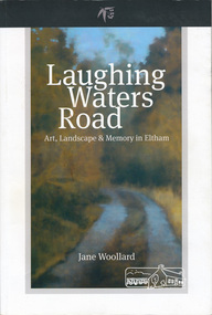
Book, Shire of Nillumbik, Laughing Waters Road: art, landscape & memory by Jane Woollard, 2016
... Since 2001 more than eighty artists have been in residence at Laughing Waters in Birrarung House and Riverbend. Their experiences and art making are woven together with Wurundjeri, European and family histories to create an evocative account of a special place in a bushy outer suburb of Melbourne." -- back cover. ...Since 2001 more than eighty artists have been in residence at Laughing Waters in Birrarung House and Riverbend. Their experiences and art making are woven together with Wurundjeri, European and family histories to create an evocative account of a special place in a bushy outer suburb of Melbourne." -- back cover. ..."Laughing Waters has been a source of inspiration for many artists and designers, and was a natural extension of the dynamic art and lifestyle movement that began in the 1930s at Montsalvat. It was also an important site in the development of the Melbourne art scene in the 1960s and '70s, especially the earth building movement known as the Eltham Style. Since 2001 more than eighty artists have been in residence at Laughing Waters in Birrarung House and Riverbend. Their experiences and art making are woven together with Wurundjeri, European and family histories to create an evocative account of a special place in a bushy outer suburb of Melbourne." -- back cover. Eltham District Historical Society is acknowledged in the Acknowledgments section of this book.264 pages : illustrations, maps, portraits ISBN 9780994486707laughing waters, eltham, yarra river, artists, killeavey, mud bricks -
 Eltham District Historical Society Inc
Photograph, Peter Pidgeon, Killeavey, Laughing Waters Road, Eltham 5 Nov 2016, 5 Nov 2016
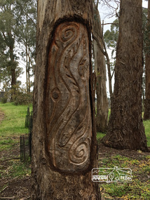
... European settlement. The Wurundjeri built the eel trap in an area where the eels gathered and has proven to still be highly effective today Heriitage Excursion - Kileavey Walk and Talk activities eltham district historical society heritage excursion kileavey parks victoria laughing waters road eltham wurundjeri Born Digital Killeavey, Laughing Waters Road, Eltham 5 Nov 2016 Photograph Peter Pidgeon ...This carving represents the eels and eel trap which was discovered by Cam in the Yarra below Killeavey and has been established to be ore European settlement. The Wurundjeri built the eel trap in an area where the eels gathered and has proven to still be highly effective today Heriitage Excursion - Kileavey Walk and TalkBorn Digitalactivities, eltham district historical society, heritage excursion, kileavey, parks victoria, laughing waters road, eltham, wurundjeri -
 Queenscliffe Maritime Museum
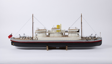
Craft - Model Cerberus, Charles Bonnici, November 2021
... Demonstrating cutting edge maritime military technology, the Cerberus patrolled the waters in and around Melbourne, protecting it and its rich gold resources from attack. The Victorian gold rush coincided with growing instability in Europe. ...Queenscliffe Maritime Museum 2 Wharf St Queenscliff geelong-and-the-bellarine-peninsula Demonstrating cutting edge maritime military technology, the Cerberus patrolled the waters in and around Melbourne, protecting it and its rich gold resources from attack. The Victorian gold rush coincided with growing instability in Europe. ...Demonstrating cutting edge maritime military technology, the Cerberus patrolled the waters in and around Melbourne, protecting it and its rich gold resources from attack. The Victorian gold rush coincided with growing instability in Europe. Britain and Russia prepared to face each other in battle as the threat of a second Crimean War grew.The HMVS Cerberus was one of only three vessels of its exact type ever built, and is the only surviving example of this type of vessel in the world. It is also the only substantially intact warship of Australia’s pre-Federation colonial navies. This shipwreck rests in shallow waters at Black Rock, Melbourne.HAnd built timber model of the HMVS CerberusCerberushmvs cerberus, model making -
 Ithacan Historical Society
Photograph, Portside at Kioni, Ithaca, c1930s
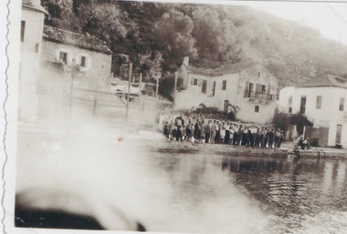
... A caïque (or kaiki) is a traditional handmade wooden fishing boat found among the waters of the Ionian or Aegean Sea and were once the main form of transport for the many Greek islands, moving people and goods across Greece's archipelago. In the 1980s and 1990s many were destroyed as a result of a European ...Kioni is a small fishing village on Ithaca where caïque boats were used by fishermen and were once an important form of transport for goods and for people prior. The people in the photograph appear to be lined up along the water's edge awaiting a boat to arrive.A caïque (or kaiki) is a traditional handmade wooden fishing boat found among the waters of the Ionian or Aegean Sea and were once the main form of transport for the many Greek islands, moving people and goods across Greece's archipelago. In the 1980s and 1990s many were destroyed as a result of a European Union decision to subsidize fishermen to scrap their boats to tackle overfishing. Hundreds of beautiful and perfectly sound vessels ended up in landfills resulting in the loss of an integral part of Greece's long seafaring tradition and heritage. Sadly Cyclone Ianos which struck the island in September 2020 destroyed many of the remaining caiques on the island.A sepia photograph, which has a partial white border. The image has been affected by light across the bottom LH corner. The visible section shows a group of people lined up along the side of a wharf like structure. There are four two storey houses in the middle distance with a hillside in the background.