
Showing 27 items matching "evelyn store"
-
 Eltham District Historical Society Inc
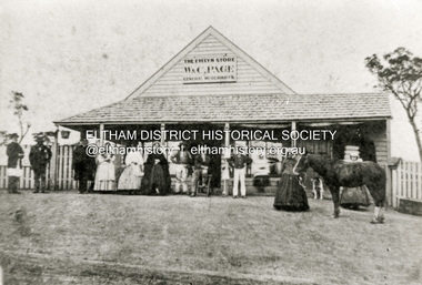
Photograph - Copy of photograph, The Evelyn Store, W. & C. Page, General Merchants, Little Eltham, located on northeast corner of Main Road and John Street, c.1865
... The Evelyn Store, W. & C. Page, General Merchants, Little Eltham, located on northeast corner of Main Road and John Street......Evelyn Store...W. and C. Page’s Evelyn Store was in the centre of the Eltham township in the 1860s. ...W. and C. Page’s Evelyn Store was in the centre of the Eltham township in the 1860s. ...W. and C. Page’s Evelyn Store was in the centre of the Eltham township in the 1860s. It was situated on the eastern side of Maria Street (Main Road) on what was Lot 355 of Josiah Holloway’s Plan of Subdivision of Little Eltham The property is described as having a frontage of one hundred and fifty one feet six inches to Maria-street by a depth of one hundred and thirty two feet with John Street on the south side. That property is now known as 816 Main Road and is occupied by Goodstart Early Learning Eltham. William Austin Page and Charlotte Moyses were married in the last quarter of 1840 in Wisbech, Cambridgeshire, England. Records of their arrival in Australia have not been found. The first record of W.A and C. Page, General Merchants is an advertisement placed in The Argus newspaper in February 1854 for The White Flag Store in Wellington Street, Collingwood. William Austin Page is next recorded in the 1856 Electoral Roll for Evelyn as a storekeeper of Little Eltham. The nature of his qualification being a dwelling house in Little Eltham. There is no C. Page recorded so it is likely that this is William’s wife. It is not known when the store was built, possibly at the direction of W. and C. Page but most likely circa 1855-1856. The Page’s previous business in 1854 being The White Flag Store in Wellington Street, Collingwood. On 21 April 1857, W.A. Page along with John Pearson, Richard Warren (owner of the Eltham Hotel), James Kiddle and Thomas Marland petitioned the Licensing Magistrates of the District of Heidelberg, seeking for better police protection for the district. They pointed out that Eltham had two hotels, a local population of about a thousand persons, a great number of them strangers employed on the public roads. The Bourke District police inspector investigated and recommended that the application be approved; and he advised the Chief Commissioner of the availability of a cottage (not very good) and a two-stalled stable with a fenced paddock of four acres, for the sum of ten shillings a week. This was William Jarrold' s cottage, on the west side of Main Road which became Eltham's first police station - with Constable George Reid in charge. In 1858 the newly established Eltham Road District Board implemented a rate charge. For the year ending October 14, 1858, William A. Page of Little Eltham was listed as the owner and occupier of a shop in Little Eltham, assessed 10 shillings based on building rate of 6d per £, the store valued at £20. The same was assessed for 1859 through 1861. The business was advertised for sale with four years remaining on the then present lease in October 1860. Apparently, there was a lack of interest as they attempted to sell the business again in September 1861 with three years remaining on the lease. Again, to no avail. No record of W.A. Page or the store appears in the 1862 rates assessment however in 1863 the store was valued at £25, owned by T. Hunniford and occupied by W.A. Page. Presumably Thomas Hunniford, purchased the property in 1862 and it may have been unoccupied for a period of time or the owner/occupier entries could have been transposed incorrectly in the rates book. In April 1863, William Austin Page, storekeeper of Little Eltham advertised his intention to have Lot 345 (sic) of Josiah Holloway’s Plan of Subdivision brought under the provisions of the Real Property Act. The property is described as having a frontage of one hundred and fifty one feet six inches to Maria-street by a depth of one hundred and thirty two feet with John Street on the south side. The actual lot described is Lot 355 and this is most likely the location of Page’s Evelyn Store. This action suggests the Pages remained owners of the property and this move was to facilitate a future sale. By September 1867 the Pages had been appointed official agents for The Leader newspaper. In January 1868 the business was once again put up for sale, the owners having been in business 12 years and desirous to return to England. Once more it did not sell and was offered again for sale in March and October of that year. Presumably businesses must have been difficult to sell in those times. No further evidence has been located so far of the Pages having sold their business, but an advertisement was placed in December 1870 offering the store and dwelling house for sale, presently occupied by the Pages. The property was finally sold January 28, 1871, by auction for £150. Whether the Pages ever did return to England, at least for a visit also has not been established but death records show William Austin Page died 12 April 1884 and his wife Charlotte died 4 August 1896. Both are buried in St Kilda Cemetery. - Research by Peter Pidgeon, EDHS, June 2026Black and white copy of photographeltham, evelyn store, general merchants, general store, shops, w. & c. page, william austin page, charlotte page (nee moyses), little eltham -
 Eltham District Historical Society Inc
Journal - Newsletter, Newsletter, No. 289 August 2026
... Contents: • Historical Societies add value by Jim Connor • Next meeting – 2:00pm Saturday 8th August 2026 • Heritage Excursion - Thursday 13th August – Local Remix, Montsalvat • Female Suffrage: Eltham Council’s Attitude by Richard Pinn • ….from our collection • The Evelyn Store, W. & C. Page, General Merchants by Peter Pidgeon • On the Thirsty Road to the Diggings by Mick Woiwod (reprinted from the August 2018 newsletter) • Slaughter Yards in Eltham Shire by Richard Pinn • Land for Sale at Little Eltham by Russell Yeoman (reprinted from the August 2018 newsletter) • Memories of Wattle Glen by Lynette Millar • Commons • Committee Member Profile: David Taylor • Life Among the Headstones by Julia Drew...Contents: • Historical Societies add value by Jim Connor • Next meeting – 2:00pm Saturday 8th August 2026 • Heritage Excursion - Thursday 13th August – Local Remix, Montsalvat • Female Suffrage: Eltham Council’s Attitude by Richard Pinn • ….from our collection • The Evelyn Store, W. & C. Page, General Merchants by Peter Pidgeon • On the Thirsty Road to the Diggings by Mick Woiwod (reprinted from the August 2018 newsletter) • Slaughter Yards in Eltham Shire by Richard Pinn • Land for Sale at Little Eltham by Russell Yeoman (reprinted from the August 2018 newsletter) • Memories of Wattle Glen by Lynette Millar • Commons • Committee Member Profile: David Taylor • Life Among the Headstones by Julia Drew The Shire of Eltham Historical Society was formed in October 1967. ...Contents: • Historical Societies add value by Jim Connor • Next meeting – 2:00pm Saturday 8th August 2026 • Heritage Excursion - Thursday 13th August – Local Remix, Montsalvat • Female Suffrage: Eltham Council’s Attitude by Richard Pinn • ….from our collection • The Evelyn Store, W. & C. Page, General Merchants by Peter Pidgeon • On the Thirsty Road to the Diggings by Mick Woiwod (reprinted from the August 2018 newsletter) • Slaughter Yards in Eltham Shire by Richard Pinn • Land for Sale at Little Eltham by Russell Yeoman (reprinted from the August 2018 newsletter) • Memories of Wattle Glen by Lynette Millar • Commons • Committee Member Profile: David Taylor • Life Among the Headstones by Julia DrewThe Shire of Eltham Historical Society was formed in October 1967. The first newsletter of the Society was issued May 1978 and has been published continuously ever since on a bi-monthly basis. With the cessation of the Shire of Eltham in late 1994, the Society's name was revised to Eltham District Historical Society and this name first appeared with issue No. 103, July 1995. The collection of the Society's newsletters provides a valuable resource on the history of the Society's activities, office bearers and committee members, guest speakers and subjects of historical interest pertinent to the former Shire of Eltham and the Eltham District.A4 newsletter distributed to members (Digital and A4 photocopy)newsletter, eltham district historical society -
 The Beechworth Burke Museum
Audio - Oral History, Jennifer Williams, Evelyn Jensen, 13th April 2000
... Mytleford Road Beechworth three mile creek three mile beechworth twin nozzleman Goldrush gold rush work mother young mother children siblings baby grandmother father isolation bush water watertanks kerosene tins wash day bath day creek gardening provide poor money oral history twentieth century recording story Evelyn Jensen / This is a digital copy of a recording that was originally captured on a cassette tape. The cassette tape is black with a horizontal white strip and is currently stored in a clear flat plastic rectangular container. ...Miss Evelyn Jensen was born in 1908 near Mytleford Road in Beechworth. Miss Jensen was a twin but she also had twelve brothers and sisters. Miss Jensen went to school when she was nine years old but did not enjoy it. Her father was a nozzleman and had a role in finding and collecting gold. More specifically, a nozzleman operated a steel barrel with an interchangeable brass nozzle that sprayed high pressure water onto rock and similar surfaces. This broke down the surface for gold to be found. Unfortunately, when he began most of the gold was already gone. Miss Jensen's mother died when Miss Jensen was sixteen. As a result, Miss Jensen had to take care of the children and run the house. This included looking after a few months old baby. Her father was away at work most days so all of the responsibility fell on her. Her grandmother was present but she was too old to help Miss Jensen. Miss Jensen and her family lived a very long way from the main town and often had to carry kerosene tins full of water half a mile to their house. This was because they have no access to water at their home. This lack of water also meant they had to either bathe in the creek or carry the water back home for a bath. On wash day, they washed their clothes in the creek too. Miss Jensen never married but continued to provide for her family. She spent her days gardening and cooking. They did not have much money so gardening was a way that they provided food for themselves. This oral history recording was part of a project conducted by Jennifer Williams in the year 2000 to capture the everyday life and struggles in Beechworth during the twentieth century. This project involved recording seventy oral histories on cassette tapes of local Beechworth residents which were then published in a book titled: Listen to what they say: voices of twentieth century Beechworth. These cassette tapes were digitised in July 2021 with funds made available by the Friends of the Burke.Miss Jensen's oral history is significant because it demonstrates the struggles of living remotely during this early part of the twentieth century. When Miss Jensen's mother died, she had to take on a lot of responsibility and did not have much support. This history sheds light on these struggles of being a young caregiver but it also gives details on how large families lived in isolated places. An example of this is the way that Miss Jensen often had to do the washing in the creek because that was the only place there was running water. In addition, Miss Jensen's story is significant because her father was a nozzleman. It indicates one of the processes was used to find gold. This oral history account is socially and historically significant as it is a part of a broader collection of interviews conducted by Jennifer Williams which were published in the book 'Listen to what they say: voices of twentieth-century Beechworth.' While the township of Beechworth is known for its history as a gold rush town, these accounts provide a unique insight into the day-to-day life of the town's residents during the 20th century, many of which will have now been lost if they had not been preserved.This is a digital copy of a recording that was originally captured on a cassette tape. The cassette tape is black with a horizontal white strip and is currently stored in a clear flat plastic rectangular container. It holds up 40 minutes of recordings on each sideEvelyn Jensen /mytleford road, beechworth, three mile creek, three mile beechworth, twin, nozzleman, goldrush, gold rush, work, mother, young mother, children, siblings, baby, grandmother, father, isolation, bush, water, watertanks, kerosene tins, wash day, bath day, creek, gardening, provide, poor, money, oral history, twentieth century, recording, story -
 Eltham District Historical Society Inc
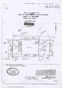
Document - Photocopy, Survey Field Notes of Part of Crown Portion 12, Section 4 at Eltham, Parish of Nillumbik, County of Evelyn, 4 July 1924
... Store Ernie Andrew franklin street L. Grant Main Road Eltham Maria Street Peel Street Pitt Street A3 printout, 1 page Survey Field Notes of Part of Crown Portion 12, Section 4 at Eltham, Parish of Nillumbik, County of Evelyn Document Photocopy ...Portion of land bounded by: Main Road, Pitt Street, Bible Street, Franklin Street Application 46030 R.H. Woodcock, Licensed Surveyor, 4 July 1924map, neil webster collection, survey plan, surveyor field notes, 1924, application 46030, bible street, corn store, ernie andrew, franklin street, l. grant, main road eltham, maria street, peel street, pitt street -
 Eltham District Historical Society Inc
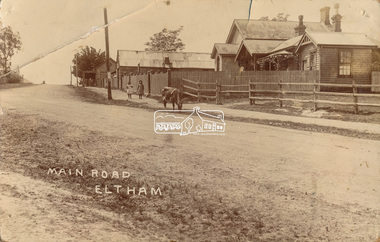
Photograph, J.H. Clark (poss), Main Road, Eltham, c.1910
... Andrew's Store on top of the hill At the upper left can be seen the front of the Evelyn Hotel. ...Andrew's Store on top of the hill At the upper left can be seen the front of the Evelyn Hotel. ...Original photo from a scrapbook belonging to Heather Jenkins (nee Cone) who lived as a child in the Police Residence at 728 Main Road, Eltham from 1911 to the early 1920s. (Reported in Newsletter No. 98, Sept., 1994). View looking north up Policeman’s Hill across Main Road towards the Police Station, Police Residence and Courthouse, c.1910 prior to Brougham Street being made. The two rails / gap in the fence would be where Brougham Street now enters Main Road. Also visible are Knapman's Forge adjacent to Courthouse and E.J. Andrew's Store on top of the hill At the upper left can be seen the front of the Evelyn Hotel. On the opposite corner was Watsons Hotel. E.J. Andrew's store with its verandah was on the corner of Franklin Street. Behind the picket fence stands the 1860 Court House and Police residence with the weatherboard clad Police office. The enclosed fence is now the end of Brougham Street, opened to Bible Street in 1926. The Evelyn Hotel (formerly Fountain of Friendship) burnt down in the 1930s when it was being used as a boarding house since 1919. A cow is feeding on the grass verge in street. The photo is identified in white lettering typical of the style of Clark Bros., photographers of Windsor, Melbourne (1894-1914). One of the brothers, John Henry Clark, took many early photos around Little Eltham and moved to Eltham in 1916 where he lived at the bottom of the hill. Typically, he would add “J.H. Clark Photo” to his personal work, but this is not evident. There is however some ghost writing, a cheeky inscription in small white lettering in the grass verge in front of where Brougham Street is, which appears to state: “Heather or Hannah was here”. Perhaps J.H. Clark took the photo during a trip to Eltham and gifted it some years later after moving there as a gift to a young Heather Cone. The Police Station sign: E vii R ELTHAM POLICE STATION HEIDELBERG DISTRICT Edward VII ascended the throne in 1901 and died 6 May 1910. He was succeeded by George V.Heather Cone was the daughter of Constable John Thomas Cone (Badge 3935) the local police officer in residence at Eltham, 1 May 1911 to 9 July 1922. Heather McKnight Jenkins (nee Cone) was born 1911, possibly at the Eltham Police Residence and spent her childhood growing up in the Police Residence. Heather was the daughter of John Thomas Cone, Police Constable, and Charlotte Helena Cone (nee Black) who had married in 1906. Constable Cone was transferred to Eltham Police Station from Lauriston (near Kyneton) in May 1911. He retired from the force around September 1922 most likely as a result of significant health concerns experienced earlier that year from 22 April when he was hospitalised. He died 5 October 1922 at Maria Street at age 60 leaving behind a widow and two daughters; his son having pre-deceased him as a result of effects of the war. He is buried in Melbourne General Cemetery . In his probate it states that he owned a piece of land 200 links frontage to Maria Street and a depth of 241 links. It is believed that this is the land opposite the Police Station which Heather Jenkins referred to as being owned by her father and where he agisted the Police horses. Heather, her sister and mother Charlotte remained in Eltham until at least the 1924 Electoral Roll where Charlotte was listed as Home Duties however by 1925 she was listed at 229 Glenferrie Road, Malvern, occupation, Registrar of Births. In the 1934 (and 1936) Electoral Roll, Heather was a Clerk and her mother Charlotte was the Registrar of Births. in 1952 following her mother’s death she made application for Grant of Probate. Heather remains listed in the 1954 Electoral Roll at 13 Ashburton Road under her maiden name Cone however by the 1963 Electoral Roll she is listed at the same address as Heather McKnight Jenkins long with James Gardiner Jenkins. Neither appear listed in the 1958 Electoral Roll. James Gardiner Jenkins (1892-1975) first wife was Fanny Davison Carrucan (1899-1929), daughter of Denis Carrucan and Jane (nee McAleese). They married in 1925. Fanny died 11 November 1929. In the 1934 Electoral Roll he remained listed at John Street, Eltham, Railway Employee however by 1935 Electoral Roll, James Gardiner Jenkins, Railway Employee, was listed at 229 Glenferrie Road, Malvern and he remained living with Charlotte and Heather Cone when they moved to 13 Ashburton Road, Glen Iris. One of Constable Cone’s first investigations upon arriving in Eltham was the accidental fatal shooting in the head with a pea rifle by young Francis August Capewell, aged 11, of John Sutcliffe Deegan, 14, in Maria Street near the Railway. Constable Cone’s replacement was Constable William Charles Sargeant who commenced in charge of the Eltham Police Station from Thursday, 10 August 1922. Constable William Charles Sargeant, and his wife Elizabeth Agnes Sargeant were based at the Eltham Police Station until his transfer to the Police Station in Burwood Road, Hawthorn. He retired at Hawthorn Police Station in 1931, described by Hawthorn Council in 1927 as in a disgraceful condition and unfit for human habitation (Kathryn Griffin family tree – Ancestry) whereupon they moved to 28 Saunders Street, Coburg. Elizabeth died 16 July 1936 in Fitzroy. William then moved to 6 Queen Street Coburg in 1936 and then 1 Queen Street in 1942 where he died 7 August 1944. He is buried at Fawkner Cemetery.Sepia postcard photo glued on a brown paper scrapbook page (torn from scrapbook) along with 8 other black and white/sepia photos of varying sizes, 1 newspaper clipping and handwritten captions in ink.brougham street, courthouse, cow, eltham, knapmans forge, little eltham, local history centre, main road, maria street, police residence, police station, policeman's hill, scrapbook, w.b. andrew corn store, j.h. clark photo, andrews store, heather jenkins (nee cone), clark bros. photo -
 Eltham District Historical Society Inc
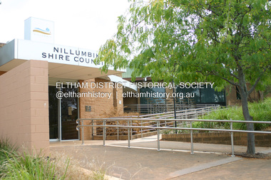
Photograph - Digital Photograph, Alan King, Nillumbik Shire Offices, Greensborough, 30 March 2008
... Store and Post Office. Then, in 1917, the council bought the former office of The Evelyn Observer, after its printing works transferred to Hurstbridge. ...Store and Post Office. Then, in 1917, the council bought the former office of The Evelyn Observer, after its printing works transferred to Hurstbridge. ...Nillumbik Shire Council transferred to the former Diamond Valley Shire Offices in Greensborough after municipal restructuing. The offices became the official Nillumbik Shire Council Offices on 16 October 1995. The former Shire of Diamond Valley Civic Centre or Shire Office building was officially opened on 26th February 1972. Archtiects were A.K. Lines, McFarlane & Marshall and it was built by L.U. Simon Pty Ltd, The Diamond Valley Shire had been created in 1964 from part of the City of Heidelberg. On December 15, 1994 the Shire of Nillumbik was established. Under the Council amalgamations imposed by the Kennett government, the Shire of Eltham, Shire of Diamond Valley and City of Heidelberg ceased to exist with the establishment of Nillumbik Shire Council and the City of Banyule.The new Nillumbik shire surrended the west riding from Eltham to Banyule but in place gained parts of the former Diamond Valley Shire which itself had been created in 1964 from parts of the City of Heidelberg. Three unelected and non-local Commissioners were put in place by the government bringing democracy into question by many members of the local community. The Commissioners determined to abandon the former Shire of Eltham offices located in Main Road, Eltham and in turn occupy the former Shire of Diamond Valley offices located at the boundary of the new shire with Banyule, in Civic Drive, Greensborough. In July 1996 the Commissioners sold the former Eltham Shire Offices and had them bulldozed leading to many years of communiity protest over the process and future development applications. The site has remained vacant ever since. Published: Nillumbik Now and Then / Marguerite Marshall 2008; photographs Alan King with Marguerite Marshall.; p43 It was the need for roads that led to this district’s first council. In 1853 a committee was formed to improve the rough roads, some in Kangaroo Ground being almost impassable in winter.1 The committee fundraised by voluntary levies and grants to improve in particular, the main road between Kangaroo Ground and the Plenty River. From this committee arose the Eltham District Road Board, in 1856, which was the precursor to the Eltham Shire Council. The Board’s first chairman was Kangaroo Ground farmer, John Barr. Secretary was the former committee’s secretary, Andrew Ross, Kangaroo Ground’s first school teacher, and founder of the district newspaper, The Evelyn Observer.2 Most of the board’s income came from a toll-house north of the Lower Plenty Bridge, which funded such projects as a road from Kangaroo Ground to the Caledonia Diggings. In 1871 the Shire of Eltham was proclaimed, with its boundaries the same as those of the Road Board, and Councillor A Donaldson of Kangaroo Ground was the first president. Eltham was at the southern tip of the shire, which extended north to Kinglake and east beyond Yarra Glen. In 1878, part of Kinglake was added to the shire, while the area east of Watts River, near Healesville was removed. In 1912, then again in 1958, the shire was further reduced. Yarra Glen, Steels Creek, Tarrawarra, parts of Healesville and Christmas Hills, were transferred to the Shire of Healesville. In 1972 a smaller area, at Kinglake, was transferred to the Shire of Yea, leaving 277 square kilometres in the Eltham Shire. Perhaps no other Victorian municipality has had so many meeting places. Although from 1858 to 1904, the council convened at the office in the home of Secretary Charles Wingrove, the board, and later the council, also met at other more central locations.3 The board moved from the Fountain of Friendship Hotel to the Eltham Courthouse, to the Kangaroo Ground schoolhouse. It then met at the Kangaroo Ground Hotel, which some considered put it in danger of interruptions by people ‘the worse for liquor’.4 In 1885 the council met at the hall on Mr J Donaldson’s land at Kangaroo Ground. After Wingrove’s retirement, the council rented space at the Kangaroo Ground General Store and Post Office. Then, in 1917, the council bought the former office of The Evelyn Observer, after its printing works transferred to Hurstbridge. In 1934, fire destroyed the shire office, which was temporarily relocated to the Kangaroo Ground home of Shire Secretary, Mr P J McMahon. In 1941, the shire office moved to a new building (which included a public hall) in Eltham, at the corner of Arthur Street and Main Road, where the Eltham Village Shopping Centre was eventually built. Growth required new offices, which opened in 1965, on the former Shillinglaw property in Main Road.5 In 1994, as part of municipal restructuring under the Jeff Kennett Liberal Government, most of the Eltham Shire formed part of the new Shire of Nillumbik. It joined with the north section of the Diamond Valley Shire and parts of the Healesville and Whittlesea municipalities. The Diamond Valley Shire had been created in 1964, from part of the City of Heidelberg. Turbulence followed Nillumbik Shire’s formation. Under the Commissioners the council transferred to the former Diamond Valley Shire offices in Greensborough, and the Eltham council offices were demolished. In March 1997 the first five-member Nillumbik Council was elected. But, in October 1998, the government suspended the council and appointed an administrator . Early in 1999, shire residents voted to increase councillors to nine: comprising five ward councillors and four shire-wide councillors. Elections were held in March 1999. Then, before the March 2002 elections, nine new wards were created.6 In 2008 these were reduced to seven. Today [2008] the council governs a varied population of more than 60,000 people living in townships and on bush properties in the green wedge.This collection of almost 130 photos about places and people within the Shire of Nillumbik, an urban and rural municipality in Melbourne's north, contributes to an understanding of the history of the Shire. Published in 2008 immediately prior to the Black Saturday bushfires of February 7, 2009, it documents sites that were impacted, and in some cases destroyed by the fires. It includes photographs taken especially for the publication, creating a unique time capsule representing the Shire in the early 21st century. It remains the most recent comprehenesive publication devoted to the Shire's history connecting local residents to the past. nillumbik now and then (marshall-king) collection, greensborough, nillumbik shire council offices, civic drive -
 Eltham District Historical Society Inc
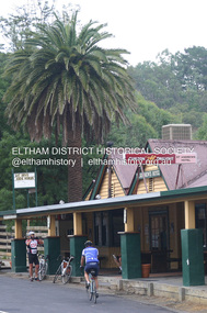
Photograph - Digital Photograph, Alan King, St Andrews Hotel, 2 February 2008
... store. In 1867 Mrs Knell was appointed Deputy Registrar of Births and Deaths for Queenstown. The hotel was also used to hold inquests into people’s deaths when the police residence became too small.6 The hotel also became a fashionable destination at Christmas for parties from Melbourne. In 1868, possibly following her husband’s death, Mrs Knell applied for a temporary licence, which was then transferred to Robert Smith after their marriage in 1869. But then, possibly after Robert’s death, Mrs Smith operated the hotel until 1892. This contradicts a report in The Evelyn...store. In 1867 Mrs Knell was appointed Deputy Registrar of Births and Deaths for Queenstown. The hotel was also used to hold inquests into people’s deaths when the police residence became too small.6 The hotel also became a fashionable destination at Christmas for parties from Melbourne. In 1868, possibly following her husband’s death, Mrs Knell applied for a temporary licence, which was then transferred to Robert Smith after their marriage in 1869. But then, possibly after Robert’s death, Mrs Smith operated the hotel until 1892. This contradicts a report in The Evelyn ...The c1860 St Andrews Hotel, with the c1930 additions, and the Canary Island Palm, and the surrounding site to the title boundaries are historically, socially and aesthetically significant to the Shire of Nillumbik. The St Andrews Hotel is historically significant because it may have given its name 'St Andrews' to the town (another suggestion is that the name came from St Andrews church) and for its connection to Ewen Hugh Cameron (1831-1915) the prosperous local farmer, member of the Eltham Roads Board/Shire Council and local MP. It is also significant as the oldest hotel building in the former Shire of Eltham, as one of the few surviving buildings connected with the Caledonian goldfields era and as one of a handful of early structures to have survived the 1960s bushfires; the additions and alterations to the hotel reflect its long life. The hotel is socially significant because it has served as an important meeting place for more than 160 years. The Canary Island Palm is historically significant as a rare example of exotic tree planting in this rural area. The tree is aesthetically and historically significant as a local landmark and for its contribution to the streetscape and landscape value. Covered under Heritage Overlay, Nillumbik Planning Scheme. Published: Nillumbik Now and Then / Marguerite Marshall 2008; photographs Alan King with Marguerite Marshall.; p71 Built around 1860, St Andrews Hotel has changed little since it first welcomed thirsty gold diggers from the Caledonia Goldfields. The timber building, with gabled roof, beamed ceilings and a massive fireplace, is Nillumbik Shire’s oldest hotel and has always been an important community centre, particularly in its early days. Fortunately, the hotel and the near-by Canary Island Palm Tree, which is quite rare in this area, survived the 1960s bushfires, along with a few other early buildings. St Andrews (formerly Queenstown) was founded on gold, as were Panton Hill (formerly Kingstown), Research and Diamond Creek, from the mid-1850s to the 1860s. But by the early 20th century common use changed the name Queenstown to St Andrews, possibly after this hotel or after the church or the mining district.1 The Caledonia Diggings were probably named by Scottish settlers after the Roman name for Scotland, despite this land bearing little similarity to their homeland.2 Queenstown, which was proclaimed as a township in 1861, was the gold-mining centre on the Upper Diamond and in the 1850s had up to 600 European inhabitants and a small camp of Chinese on the flats along the creek. Queenstown was the administrative centre of the Upper Diamond with three hotels, a brewery and a slaughterhouse.3 It is unclear which hotel was the district’s first, as distinct from the earliest unlicensed grog shops, some of which operated in tents. John Corke Knell was one of eight unlicensed storekeepers supplying drink to miners at Caledonia in 1857, named by Sgt. McNamara of the Caledonia Police Station.4 In February 1859, Knell apparently bought most of the present hotel’s site at the first township land sales. As he was a local storekeeper, he might have first established a store there.5 Knell and his wife Eliza were early licensees of the St Andrews Hotel. The hotel had eight bedrooms – including three for public use – and the dining-room seated 30 people. It is thought they named the hotel St Andrews after Eliza’s hometown of St Andrews in Scotland. St Andrews Hotel was an important local centre in several ways. In the same building the Knells also operated a post office and general store. In 1867 Mrs Knell was appointed Deputy Registrar of Births and Deaths for Queenstown. The hotel was also used to hold inquests into people’s deaths when the police residence became too small.6 The hotel also became a fashionable destination at Christmas for parties from Melbourne. In 1868, possibly following her husband’s death, Mrs Knell applied for a temporary licence, which was then transferred to Robert Smith after their marriage in 1869. But then, possibly after Robert’s death, Mrs Smith operated the hotel until 1892. This contradicts a report in The Evelyn Observer 1882 that JC Knells of the St Andrews Hotel was granted a publican’s licence in the Queenstown Police Court. At that time he was supposed to have been dead for around 14 years! Although Mrs Smith was a respected citizen, known for her geniality and as an ideal hostess, she had a minor brush with the law when she was fined ten shillings for not lighting a lamp outside her licensed premises.7 From 1892 several publicans owned the hotel including W Atkins, from 1895. In 1909 the licensee was apparently Mrs Smith’s son, Walter Knell, who held the licence until at least the 1920s. Not surprisingly, this old hotel has attracted romantic stories. Mrs Smith is said to be seen roaming the pub in her nightdress – even though she was buried in the Queenstown Cemetery in 1911.8 A musical The Hero of Queenstown, set in the hotel, was written and produced by local actor Reg Evans in the 1970s.This collection of almost 130 photos about places and people within the Shire of Nillumbik, an urban and rural municipality in Melbourne's north, contributes to an understanding of the history of the Shire. Published in 2008 immediately prior to the Black Saturday bushfires of February 7, 2009, it documents sites that were impacted, and in some cases destroyed by the fires. It includes photographs taken especially for the publication, creating a unique time capsule representing the Shire in the early 21st century. It remains the most recent comprehenesive publication devoted to the Shire's history connecting local residents to the past. nillumbik now and then (marshall-king) collection, st andrews hotel -
 Eltham District Historical Society Inc
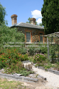
Photograph - Digital Photograph, Alan King, Ellis Cottage, Diamond Creek, 23 January 2008
... stored farm produce. Water came from a well as reticulated water did not arrive at Diamond Creek until 1914. In 1870 Ellis’ 22 year-old nephew Nathaniel joined him from England.2 Until 1890 they developed Ellis Park, praised in The Evelyn Observer, May 30,1890 as a model farm. ...stored farm produce. Water came from a well as reticulated water did not arrive at Diamond Creek until 1914. In 1870 Ellis’ 22 year-old nephew Nathaniel joined him from England.2 Until 1890 they developed Ellis Park, praised in The Evelyn Observer, May 30,1890 as a model farm. ...Built by William Ellis in 1865 of local uncut stone about 30cm thick, the cottage is now a museum and home to the Nillumbik Historical Society. Ellis Cottage is historically significant for its association with the Ellis family, who were pioneers of the Diamond Creek district and the benefactors of the notable Nillumbik Cemetery gateway. It illustrates the development of farming in the area. Ellis Cottage is historically and technically significant for its rare use of uncut local stone for building purposes. Covered under Heritage Overlay, Nillumbik Planning Scheme. National Estate Published: Nillumbik Now and Then / Marguerite Marshall 2008; photographs Alan King with Marguerite Marshall.; p79 Ellis Cottage, built by William Ellis, is a memorial to the courage of pioneers in the Diamond Valley area.1 Now a museum and home to the Nillumbik Historical Society, it is a fine example of an early settler’s house in Diamond Creek – and one of the few original buildings standing from the middle of the 19th century. It is a poor man’s cottage – typical of the dwellings of those who had to work hard to wrest a living in this district, because most of the land was not fertile enough for major forms of farming. The pretty stone cottage at 10 Nillumbik Square, built in 1865, is made of local uncut stone about one foot (30 cm) thick. It once stood near the centre of the 147 acres (59.4ha) Ellis bought in 1850. The property extended from Diamond Creek to Reynolds Road and from Perversi Avenue to the Wattle Glen School. It stood in the electoral parish of Nillumbik. The Nillumbik township (later called Diamond Creek) was not created until 1867. In 1912 the property was cut in half by the new railway to Hurstbridge. Ellis paid £147/10/- for the land - about three times what a Victorian farmer would usually earn in a year. Despite the poor quality soil Ellis became a very successful farmer with an orchard, vegetables and a dairy herd. Five years later, in 1855, Ellis bought 70 acres (28.3ha) from neighbour, Hugh Larimour. In 1857 Ellis bought 208 acres (84ha) at Yarra Glen. In 1877 he bought 122 acres (49.3ha) at Diamond Creek and later bought land at Greensborough and Woodstock. Ellis was born in 1815 at Blackawton, a small Devonshire village, and became a tenant farmer. It is not known why Ellis came out to Australia or settled in Diamond Creek. In 1847 he married Margaret Child at the Melbourne Presbyterian Church. Ellis and Child had no children and 18 years after the wedding, while probably living in Kangaroo Ground, Ellis built this small cottage. The simple cottage has a central hall and two rooms on each side. To maximise the small space the ceiling cavity was designed large enough to provide sleeping accommodation accessed via a ladder. Each room was heated by an open fireplace and the one in the kitchen was large enough to roast a sheep. A large cellar under the front room probably stored farm produce. Water came from a well as reticulated water did not arrive at Diamond Creek until 1914. In 1870 Ellis’ 22 year-old nephew Nathaniel joined him from England.2 Until 1890 they developed Ellis Park, praised in The Evelyn Observer, May 30,1890 as a model farm. Ellis had become wealthy, and on his death in 1896 his estate was valued at £9000. In his will he left £100 to construct memorial gates at the Nillumbik Cemetery where he was buried.3 Ellis left the farm to his second wife Louisa. As he had no children, upon her death the farm passed to Nathaniel, but he did not take it up. The farm was sold and leased several times until 1967, when engineer Phillip Lovitt bought the property and carried out major structural works. The Shire of Diamond Valley bought it in the 1980s and in 1989 restored it with the Nillumbik Historical Society. The stone walls of the cottage had been plastered with mud and straw mortar, which were removed as they were riddled with vermin. Doors, windows and a floor were replaced and the original roof of timber shingles had been replaced with slate. The well was too deeply cracked to be restored, so was used for a flower bed. Two mature Italian Cypresses at the entry are also heritage protected as they relate to similar trees planted at Shillinglaw Cottage and other early buildings in Nillumbik Shire.This collection of almost 130 photos about places and people within the Shire of Nillumbik, an urban and rural municipality in Melbourne's north, contributes to an understanding of the history of the Shire. Published in 2008 immediately prior to the Black Saturday bushfires of February 7, 2009, it documents sites that were impacted, and in some cases destroyed by the fires. It includes photographs taken especially for the publication, creating a unique time capsule representing the Shire in the early 21st century. It remains the most recent comprehenesive publication devoted to the Shire's history connecting local residents to the past. nillumbik now and then (marshall-king) collection, ellis cottage, diamond creek, nillumbik historical society, william ellis -
 Eltham District Historical Society Inc
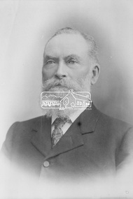
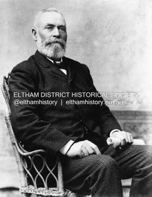
Photograph, The Hon. Ewen Hugh Cameron, Member for Evelyn in Legislative Assembly, Victorian Parliament, for 40 years from 1874-1914
... store there. In 1863 he took up the 100 acre farm “Pigeon Bank” at Kangaroo Ground where he lived until his death. In 1874 Cameron was elected as the Member for Evelyn in the Victorian Legislative Assembly and held the seat until he retired in 1914 as “Father of the House”. ...store there. In 1863 he took up the 100 acre farm “Pigeon Bank” at Kangaroo Ground where he lived until his death. In 1874 Cameron was elected as the Member for Evelyn in the Victorian Legislative Assembly and held the seat until he retired in 1914 as “Father of the House”. ...Ewen Hugh Cameron (1831- 27 September 1915) was born at Kilmonivaig, Inverness Scotland. He migrated to Melbourne in “The Hurricane” in 1853 and in 1855 tried his luck at the newly-opened Andersons Creek Goldfield. Two years later he was appointed first postmaster at Warrandyte and ran the store there. In 1863 he took up the 100 acre farm “Pigeon Bank” at Kangaroo Ground where he lived until his death. In 1874 Cameron was elected as the Member for Evelyn in the Victorian Legislative Assembly and held the seat until he retired in 1914 as “Father of the House”. He held a number of ministerial and other important Parlimentary positions. The most notable was Chairman of the Railways Standing Committee, which was responsible for much of the Railway development in Victoria. Concurrently with his Parliamentary career, he was a member of the Eltham Roads Board and later Council for more than 50 years. In 1867 he married Agnes Bell, a daughter of Kangaroo Ground pioneers. They had eight sons and three daughters.This photo forms part of a collection of photographs gathered by the Shire of Eltham for their centenary project book, "Pioneers and Painters: 100 years of the Shire of Eltham" by Alan Marshall (1971). The collection of over 500 images is held in partnership between Eltham District Historical Society and Yarra Plenty Regional Library (Eltham Library) and is now formally known as the 'The Shire of Eltham Pioneers Photograph Collection.' It is significant in being the first community sourced collection representing the places and people of the Shire's first one hundred years.Digital imagesepp, shire of eltham pioneers photograph collection, kangaroo ground, e.h. cameron, member for evelyn, victorian parliament, legislative assembly, ewen cameron, ewen hugh cameron -
 Eltham District Historical Society Inc
Photograph, Ewen Hugh Cameron (1832-1915), c.1910
... store there. In 1863 he took up the 100 acre farm “Pigeon Bank” at Kangaroo Ground where he lived until his death. In 1874 Cameron was elected as the Member for Evelyn in the Victorian Legislative Assembly and held the seat until he retired in 1914 as “Father of the House”. ...store there. In 1863 he took up the 100 acre farm “Pigeon Bank” at Kangaroo Ground where he lived until his death. In 1874 Cameron was elected as the Member for Evelyn in the Victorian Legislative Assembly and held the seat until he retired in 1914 as “Father of the House”. ...Ewen Hugh Cameron (1831- 27 September 1915) was born at Kilmonivaig, Inverness Scotland. He migrated to Melbourne in “The Hurricane” in 1853 and in 1855 tried his luck at the newly-opened Andersons Creek Goldfield. Two years later he was appointed first postmaster at Warrandyte and ran the store there. In 1863 he took up the 100 acre farm “Pigeon Bank” at Kangaroo Ground where he lived until his death. In 1874 Cameron was elected as the Member for Evelyn in the Victorian Legislative Assembly and held the seat until he retired in 1914 as “Father of the House”. He held a number of ministerial and other important Parlimentary positions. The most notable was Chairman of the Railways Standing Committee, which was responsible for much of the Railway development in Victoria. Concurrently with his Parliamentary career, he was a member of the Eltham Roads Board and later Council for more than 50 years. In 1867 he married Agnes Bell, a daughter of Kangaroo Ground pioneers. They had eight sons and three daughters. This photo forms part of a collection of photographs gathered by the Shire of Eltham for their centenary project book,"Pioneers and Painters: 100 years of the Shire of Eltham" by Alan Marshall (1971). The collection of over 500 images is held in partnership between Eltham District Historical Society and Yarra Plenty Regional Library (Eltham Library) and is now formally known as the 'The Shire of Eltham Pioneers Photograph Collection.' It is significant in being the first community sourced collection representing the places and people of the Shire's first one hundred years.Digital image B&W printsepp, shire of eltham pioneers photograph collection, kangaroo ground, e.h. cameron, member for evelyn, victorian parliament, legislative assembly, ewen cameron, ewen hugh cameron, ewan hugh cameron, people, pigeon bank -
 Eltham District Historical Society Inc
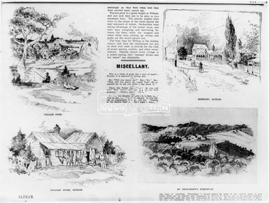
Photograph, The Australasian, Eltham - A series of four scenes of the local district, 2 May 1903
... store...hostelery...orchardist's homestead...village pond...eltham...Dalton Street...Evelyn...It is significant in being the first community sourced collection representing the places and people of the Shire's first one hundred years. sepp shire of eltham pioneers photograph collection drapery store hostelery orchardist's homestead village pond eltham Dalton Street Evelyn Hotel Hostelry Jarrold Cottage John Street Main Road Maria Street White Cloud Cottage Digital image Print B&W 20 x 25 cm Eltham - A series of four scenes of the local district Photograph Photograph The Australasian ...Australasian (Melbourne, Vic. : 1864 - 1946), Saturday 2 May 1903, page 25 ________________________________________ ELTHAM A POPULAR HOLIDAY SPOT. By L.J.J. The village of Eltham, with its 377 in habitants, is prettily situated on Diamond Creek, a tributary of the Yarra, 16 miles from Melbourne. Yet, in spite of it being so easily accessible from town, few people are aware of the beauties of this early settlement. Prior to June last year one had to journey by coach from Heidelberg to Eltham, but now the railway conveys passengers through from Melbourne to Eltham, first-class return, for 1/9. The opening of this extension to Eltham was the last ceremony performed by Lord Hopetoun, on June 5, 1902, prior to his departure from Australia. Sauntering through the township one autumn morning recently I was constantly reminded of scenes characteristic of Surrey or Sussex villages. There is the village pond (so essentially English), reflecting in its clear water a quaint cottage, dwarfed by a huge gum tree, an old smithy, and a hostelry, built quite fifty years ago, the flooring-boards of which the landlord informed me with pride were of Singapore cedar, and quite fit for another fifty years' wear. Then there are the village school, the shoemaker's, the drapery store, and the butcher's shop, all seemingly as they were when first they were erected many years ago. Poplars grow to a great height at Eltham, and just now they are to be seen in rich autumnal tints. The already leafless fruit trees on the slopes of the creek denote the near approach of winter. Orchardists were taking advantage of the recent rains, and were busy ploughing and harrowing between the trees, while the magpies and other birds were picking up worms and grubs on the newly-turned soil. The busy time for Eltham is the holiday season, and then the inhabitants are put to their wits' ends to provide for the rush of picnic parties, cyclists, and other excursionists. Outside almost every cottage is a notice stating that "summer drinks and hot water" are obtainable. Sketches illustrating the article: VILLAGE POND. DRAPERY STORE, ELTHAM. ON DIAMOND CREEK. HOSTELRY, ELTHAM. AN ORCHADIST'S HOMESTEAD. ON THE HEIDELBERG-ROAD IN AND AROUND ELTHAM.This photo forms part of a collection of photographs gathered by the Shire of Eltham for their centenary project book,"Pioneers and Painters: 100 years of the Shire of Eltham" by Alan Marshall (1971). The collection of over 500 images is held in partnership between Eltham District Historical Society and Yarra Plenty Regional Library (Eltham Library) and is now formally known as the 'The Shire of Eltham Pioneers Photograph Collection.' It is significant in being the first community sourced collection representing the places and people of the Shire's first one hundred years.Digital image Print B&W 20 x 25 cmsepp, shire of eltham pioneers photograph collection, drapery store, hostelery, orchardist's homestead, village pond, eltham, dalton street, evelyn hotel, hostelry, jarrold cottage, john street, main road, maria street, white cloud cottage -
 Eltham District Historical Society Inc
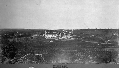
Negative - Photograph, Eltham, Vic, c.1890
... Evelyn Hotel...franklin street...Grant house...Knapmans Forge...Main Road...Maria Street...Orchards...police residence...Police Station...Pre 1900...Stebbing Cottage...sunnyside...W.B. Andrew Corn Store...It is significant in being the first community sourced collection representing the places and people of the Shire's first one hundred years. shire of eltham pioneers photograph collection eltham 1890 Bible Street Brougham Steet Dalton Street Eltham Courthouse eltham hotel Evelyn Hotel franklin street Grant house Knapmans Forge Main Road Maria Street Orchards police residence Police Station Pre 1900 Stebbing Cottage sunnyside W.B. Andrew Corn Store ...View looking northeast from present day Ely Street (near intersection of present day Cronus Court and Porter Street) across what will become the site of Eltham High School towards Main Road showing the Eltham Courthouse and Police station. View is very similar to the sketch of Eltham published in 'The Illustrated Australasian News', December 26, 1884, p212. Note the large bluestone cell block behind police house and stable. George Knapman's Shoeing Forge next to the courthouse and the concentration of buildings around the Evelyn Hotel and Watson's Eltham Hotel on opposite sides of Main Road at Pitt street. Also note George Stebbing's cottage (c.1860) on Pitt Street behind the courthouse and 'Sunnyside' (home of W.J. Taylor built c.1885) at the top of the hill on Bible Street. In the foreground are orchards running up to the main street, Maria Street and also between Brougham Street and Dalton Street bordered by Bible Street.This photo forms part of a collection of photographs gathered by the Shire of Eltham for their centenary project book,"Pioneers and Painters: 100 years of the Shire of Eltham" by Alan Marshall (1971). The collection of over 500 images is held in partnership between Eltham District Historical Society and Yarra Plenty Regional Library (Eltham Library) and is now formally known as the 'The Shire of Eltham Pioneers Photograph Collection.' It is significant in being the first community sourced collection representing the places and people of the Shire's first one hundred years.Digital image 4 x 5 inch B&W Negshire of eltham pioneers photograph collection, eltham, 1890, bible street, brougham steet, dalton street, eltham courthouse, eltham hotel, evelyn hotel, franklin street, grant house, knapmans forge, main road, maria street, orchards, police residence, police station, pre 1900, stebbing cottage, sunnyside, w.b. andrew corn store, watsons hotel, little eltham -
 Eltham District Historical Society Inc
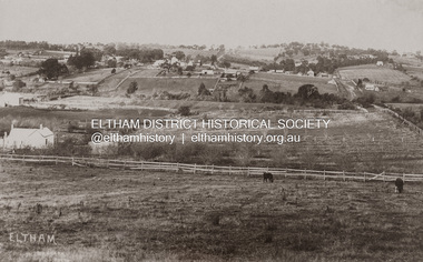
Photograph - Photograph postcard, J.H. Clark, Eltham (from Bolton Street), c.1915
... Originally dated as pre-1877 introduction of the Telegraph (the Telegraph was connected to the Post Office on Thursday, June 7, 1877) given the lack of poles and wires visible, a more recent higher resolution scan has revealed more detail highlighting the presence of several Telegraph poles: one about half way between Brougham Street and Dalton Street, one opposite the Police Residence, another opposite W.B Andrew’s Corn Store (Zen Den site), one possibly near the Fountain/Evelyn Hotel. Also, given the photo was originally marked “J. ...Originally dated as pre-1877 introduction of the Telegraph (the Telegraph was connected to the Post Office on Thursday, June 7, 1877) given the lack of poles and wires visible, a more recent higher resolution scan has revealed more detail highlighting the presence of several Telegraph poles: one about half way between Brougham Street and Dalton Street, one opposite the Police Residence, another opposite W.B Andrew’s Corn Store (Zen Den site), one possibly near the Fountain/Evelyn Hotel. Also, given the photo was originally marked “J. ...Original sepia photo postcard of early view of Eltham looking east from Bolton Street between Bridge Street and Brougham Street (Wellington). Fenced road reserve on right is Brougham Street. Originally dated as pre-1877 introduction of the Telegraph (the Telegraph was connected to the Post Office on Thursday, June 7, 1877) given the lack of poles and wires visible, a more recent higher resolution scan has revealed more detail highlighting the presence of several Telegraph poles: one about half way between Brougham Street and Dalton Street, one opposite the Police Residence, another opposite W.B Andrew’s Corn Store (Zen Den site), one possibly near the Fountain/Evelyn Hotel. Also, given the photo was originally marked “J. H. Clark Photo” it is safer to assume the image is dated circa 1915 until dates of further image details can be confirmed. Photographer: J.H. Clark John Henry Clark was the youngest of three boys born to William Henry Clark (1823-1877) and Maria White (1843-1914). He and his brothers, William Charles Clark (1872-1945), Clement Kent Clark (1874-1912) operated a photography business (Clark Bros.) from 25 Thomas Street, Windsor near Prahran during the period c.1894 to 1914. Following death of Clement in September 1912 and their mother in 1914, the Clark Bros business appears to have dissolved, the premises demolished, and a new house was under construction in 1915. John set up business independently in 1914 operating out of 29 Moor Street, Fitzroy where he is registered in the 1914 and 1915 Electoral Rolls. By 1916 John had relocated to Eltham where he continued his practice as a photographer and took many of the early images around the district of Little Eltham. Around 1930 John changed professions and opened a small cobbler's shop in 1931 near the pond opposite Dalton Street adjacent to the Jarrold family cottage. He never married and continued his profession as a bootmaker from this little shop, maintaining a close relationship with Mrs Jarrold for the rest of their lives. His bootmaker shop remains today beside the Whitecloud cottage and is one of only three remaining shops in the area from the early 20th century. There are a couple of images of Eltham taken by Clark Bros. in the Eltham District Historical Society collection, one such example being Hunniford’s Post Office with Miss Anne Hunniford out front (EDHS_00140 - marked on the back of the print, Clark Bros., 25 Thomas St. Windsor), which would date this image between c.1894 and 1914. Other early images of Eltham taken by John Henry Clark are marked on the face “J. H. Clark Photo” and it is assumed these are dated between 1914 and 1930. It is noted that the Grant of Probate for John H Clark of Eltham South dated 5 April 1957 (513/387) records his occupation as "X Photographer".1. Original sepia postcard - water damaged lower left corner over approximate 30mm diameter destroying image and photohgrapher's markings (same as EDHS_00533 and EDHS_00535 - all from same donor collection) 2. A second black and white print copy of the same image from a different unknown source (of lower resolution quality) is also held. 3. A digital enhanced version has been created using the lower quality black and white print as a donor source for the damaged section of the postcard.In pencil on back of postcard: A. Petrie Verandah on Andrews shop Pearsons house (Living and Learning Centre)bolton street, brougham street, cafe zen den, courthouse, eltham courthouse, eltham hotel, eltham living and learning centre, eltham living and learning, eltham, fountain hotel, j.h. clark photo, knapmans forge, main road, maria street, pitt street, police residence, police station, post office, st margaret’s church, w.b. andrew corn store, wellington street, early eltham, little eltham -
 Bendigo Historical Society Inc.
Slide - Mouat Crawford Collection: Farming Life in the Wimmera, c1960s
... Stores in background include Ezywalkin Shoe store, A G Trelgar Optical, Evelyn Amor, W and T Jones Chemist, E G Amor Gowns. ...Stores in background include Ezywalkin Shoe store, A G Trelgar Optical, Evelyn Amor, W and T Jones Chemist, E G Amor Gowns. ...BHS CollectionBendigo Charing Cross, corner Pall Mall and Mitchell Streets. Includes a tram, pedestrians and vehicles. Sign board directing traffic to Melbourne, Castlemaine, Shepparton, Heathcote, and Echuca. Stores in background include Ezywalkin Shoe store, A G Trelgar Optical, Evelyn Amor, W and T Jones Chemist, E G Amor Gowns. No traffic lights, tram line still going up Mitchell Street. Used as a teaching aid.ILFORDbendigo, charing cross, tram, pall mall, mouat crawford collection -
 Bendigo Historical Society Inc.
Photograph - BENDIGO ADVERTISER COLLECTION: AXEDALE GENERAL STORE, 16/06/1993
... Store with car parked in front. Photo appears in 'Small Towns With Big Hearts' series. Owners are Alan and Evelyn Matthews (from the article)....Store with car parked in front. Photo appears in 'Small Towns With Big Hearts' series. Owners are Alan and Evelyn Matthews (from the article). ...Axedale General Store with car parked in front. Photo appears in 'Small Towns With Big Hearts' series. Owners are Alan and Evelyn Matthews (from the article).Bill Hawkingregion, small towns, axedale -
 Coal Creek Community Park & Museum
Ladies Nightdress and Undergarments, C1890
... Evelyn Carfrae was a long time volunteer in O.Gilpins Store at Coal Creek....Evelyn Carfrae was a long time volunteer in O.Gilpins Store at Coal Creek. 9056.1 Ladies long white nightdress with lace trimmed collar 9056.2 Ladies white mid calf length crotch less undergarment 9056.3 Ladies white calf length undergarment with drop down panel in front Ladies Nightdress and Undergarments ...These garments were made by Evelyn Carfrae's grandmother for her trousseau around 1890. Evelyn Carfrae was a long time volunteer in O.Gilpins Store at Coal Creek.9056.1 Ladies long white nightdress with lace trimmed collar 9056.2 Ladies white mid calf length crotch less undergarment 9056.3 Ladies white calf length undergarment with drop down panel in front -
 Mount Evelyn History Group
Photograph: Fire at 'Do Drop In', "Heat of the night" - the fire at 'Do Drop In'
... store and hall from 1937 until 1955. It also served as a bus terminal up until 1979. The shop, hall and vintage buses were destroyed by fire 4 May 1980. The original holiday house was still occupied until 1982. York on Lilydale now occupies the site of Do Drop In. 'Do Drop In' was an important institution in Mt Evelyn ...Do Drop In was a general store and hall from 1937 until 1955. It also served as a bus terminal up until 1979. The shop, hall and vintage buses were destroyed by fire 4 May 1980. The original holiday house was still occupied until 1982. York on Lilydale now occupies the site of Do Drop In.'Do Drop In' was an important institution in Mt Evelyn for many decades. The fire destroyed this part of the history of the village, so it is nice to have this photo as a memento of this event.Photograph mounted on particle board.Labels on back indicating that the photograph has been in an exhibition. Signed by the entrant: Don F. Trapnell. Title of photo: "The heat of the night"do drop in, fire, general store, hall, bus depot, photograph, -
Eltham District Historical Society Inc
Document - Folder, Page, William Austin
... ...W & C Page store at Evelyn...Evelyn) and a petitioner for Eltham District Road Board and Eltham police station. He died 1884, aged 75, in South Yarra. Contents Notes no date or author: Research on William Austin Page. William Austin Page W & C Page store ...William Austin Page was, in the 1868 Post Office Directory, a resident of Eltham township, a storekeeper (W & C Page, at Evelyn) and a petitioner for Eltham District Road Board and Eltham police station. He died 1884, aged 75, in South Yarra. Contents Notes no date or author: Research on William Austin Page.Newspaper clippings, A4 photocopies, etcwilliam austin page, w & c page store at evelyn, eltham police station, eltham district road board -
Kew Historical Society Inc
Archive (Sub-series) - Subject File, Kew Historical Society, HALFEY, John, 1960
... storing information about subjects relating to the history of Kew and its environs, of which this file is an example. Typically files will contain primary and secondary sources. kew historical society - archives john halfey ordsall southesk annie halfey Small file on John Halfey, the second Chairman of Kew, comprised of draft undated correspondence from the then Secretary of the Society, Ms. Evelyn ...Various partiesReference, Research, InformationSecondary Values (KHS Imposed Order)Small file on John Halfey, the second Chairman of Kew, comprised of draft undated correspondence from the then Secretary of the Society, Ms. Evelyn West, seeking information on John Halfey. The file also comprises a typed copy of the notice of his death from The Herald, January 4 1889, and a page of research notes on Halfey. These documents date from the 1960s. kew historical society - archives, john halfey, ordsall, southesk, annie halfeykew historical society - archives, john halfey, ordsall, southesk, annie halfey -
 Merbein District Historical Society
Photograph, Merbein Central School - Grade Three and Four girls, 1939
... Doreen Quinsey Violet Davis Margaret Moore Elsie Rose Jean Cook Lois Gilkes Betty Loveridge Betty Williams Edna Chiselett Dorothy Loveridge Isobel Loveridge Beryl Whitford Joan Storer Nancy Andrews Berna Gallagher Jessie McMahon Margaret Chamberlain Ruth Storer Patty Vann Jean Eastwood Betty Bray June Treffene Barbara Hards Dorothy Griffiths Ursula ? Betty Droscher Dorothy Worthington Judith Crozier Mavis Krake Evelyn Horsfall Alice Driscoll Thelma Farnsworth Valma Finteln School - Merbein Central School Education Merbein Central School - Grade Three and Four girls Photograph ...doreen quinsey, violet davis, margaret moore, elsie rose, jean cook, lois gilkes, betty loveridge, betty williams, edna chiselett, dorothy loveridge, isobel loveridge, beryl whitford, joan storer, nancy andrews, berna gallagher, jessie mcmahon, margaret chamberlain, ruth storer, patty vann, jean eastwood, betty bray, june treffene, barbara hards, dorothy griffiths, ursula ?, betty droscher, dorothy worthington, judith crozier, mavis krake, evelyn horsfall, alice driscoll, thelma farnsworth, valma finteln, school - merbein central school, education -
 Merbein District Historical Society
Photograph, Merbein school students, unknown
... Merbein School students Jen Woods Rosemary Cambridge Joan Storer Margaret Bannister Shirley Bland Evonne Lockwood Dawn Stubbs Nola Worthington Judith Holcombe Ruth Walker Evelyn Gainsberg Gwen Mann Merbein Cliffs Merbein school students Photograph ...merbein school students, jen woods, rosemary cambridge, joan storer, margaret bannister, shirley bland, evonne lockwood, dawn stubbs, nola worthington, judith holcombe, ruth walker, evelyn gainsberg, gwen mann, merbein cliffs -
Merbein District Historical Society
Photograph, Merbein Central School Grade Five Girls, 1945
... Gwen Murray Nola Worthington Judith Holcombe Ruth Walker Evelyn Gansberg Gwenda Mann Valerie Potter Yvonne Lockwood Dorothy Cattermole Jocelyn Tuckwell Shirley Ruddick Dawn Stubbs Jennifer Woods Rosemary Cambridge Joan Storer Lois Jones Margaret Bannister Shirley Brand Education Merbein Central School Grade Five Girls Photograph ...gwen murray, nola worthington, judith holcombe, ruth walker, evelyn gansberg, gwenda mann, valerie potter, yvonne lockwood, dorothy cattermole, jocelyn tuckwell, shirley ruddick, dawn stubbs, jennifer woods, rosemary cambridge, joan storer, lois jones, margaret bannister, shirley brand, education -
 Wodonga & District Historical Society Inc
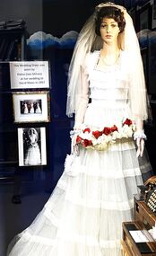
Costume - Wedding dress- Elaine Mann nee Milnes 1957
... Evelyn Mann of Wodonga who had operated the family business since 1921. David joined the business in 1945 and became the Managing Director of Mann Wodonga from 1965. Under his management and leadership, it expanded to become one of Australia’s largest regional shopping centres, with a Supermarket, Hardware Store, Steel Store, Plumbing and Industrial supplies store, at one stage employing over 100 people. ...Evelyn Mann of Wodonga who had operated the family business since 1921. David joined the business in 1945 and became the Managing Director of Mann Wodonga from 1965. Under his management and leadership, it expanded to become one of Australia’s largest regional shopping centres, with a Supermarket, Hardware Store, Steel Store, Plumbing and Industrial supplies store, at one stage employing over 100 people. ...Elaine Margaret Milnes of Tallangatta married David Ernest Mann of Wodonga on 30 March 1957. At the time of their first meeting, Elaine was living in Tallangatta where her father had moved as a bank manager. She was a member of the Drama Club. She and David met at the Rutherglen Town Hall whilst attending an Arts Festival. David was attending as a member of the Wodonga Music Club. David Mann was the son of Ernest and Evelyn Mann of Wodonga who had operated the family business since 1921. David joined the business in 1945 and became the Managing Director of Mann Wodonga from 1965. Under his management and leadership, it expanded to become one of Australia’s largest regional shopping centres, with a Supermarket, Hardware Store, Steel Store, Plumbing and Industrial supplies store, at one stage employing over 100 people. He continued to head the business until it was sold in 2006. He was a leader in many other fields in the Wodonga community, from leading the Wodonga Chamber of Commerce to Scouting, Apex and Rotary and was a prime mover in establishing Aware Industries for people with disabilities. He chaired the Wodonga Chamber of Commerce on several occasions. David was a man of vision who was involved in many charitable and community organisations. These included membership of the hospital board and President of the Wodonga High School Council. was a prime mover in establishing Aware Industries for people with disabilities. Elaine also played an active role in the business. She developed and managed a quality giftware department from 1969 to 1987. Some of her local involvements included the School Mothers’ Club and Kindergarten, Girl Guides, the Quota and Penguin Clubs and Meals on Wheels. David also advocated passionately for the development of a university and TAFE to be established in Wodonga. In 1993 he inaugurated the Jonathan Mann lectures series at La Trobe University in honour of his grandfather. The university honoured Mr Mann in two significant ways, giving him an honorary degree of Doctorate of Law in 1998 and in 2002 named its new library the David Mann Library. David Mann died in Albury in June 2012. Elaine now (2024) lives in Melbourne. “The little I have done for Wodonga and district is only in return for what Wodonga and district has done for me.” David MannThis dress was worn by Elaine Milnes at her marriage to David Mann who became a prominent businessman and contributor to many aspects of the Wodonga community.A wedding dress dating from 30 March 1957. The dress consists of a fitted bodice with tulle frills around the body. The bodice has a square neckline decorated with tiny seeded pearls and blue stones. The long sleeves are made of sheer tulle with lace and a frill at the wrist. The skirt is made of two layers of white tulle with five lace and tulle frills around the body. Under the tulle is a pale blue satin slip with two more layers of white tulle underneath it. It was worn with a fingertip length veil held in place by a lace coronet. The bridal bouquet consisted of red and white roses. The bride also wore a single string of pearls. The dress was made by Olive Ferris Wedding Dresses of Sydney.mann wodonga, david mann, elaine mann, wodonga businesses -
 Sunshine and District Historical Society Incorporated
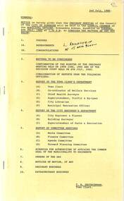
Administrative record - City of Sunshine - Commissioner Mr Alexander Alex George Gillon Collection 1976 - 1982 - Notice of ordinary meeting of the council 8th July 1980, City of Sunshine, 2nd July 1980
... Albans to Public Use Amendment 104 Part 2A to the Melbourne Metropolitan Planning Scheme Planning Permit Medical Consulting Room Sole Practice 332 Gordon Street Maidstone Planning Permit Application Retail Plant Nursey Lots 1 & 2 Ballarat Road North West Corner Miles Street Deer Park Planning Permit Application Factory and Store Lot 20 McIntyre Road and Lots 29 & 30 Cromer Avenue Sunshine North Planning Permit Application Extension to Decker Platform Beater Homes Within Existing Industrial Complex Somerville Road Brooklyn Planning Permit Furniture and Carpet Sales Units 1, 2 & 4 Lot 19 Geelong Road Corner Francis Street Brooklyn Planning Permit Application Illuminated Sky Sign Sunshine Heights Hotel Glengala Road Corner Evelyn Street Sunshine West Planning Permit Application Illuminated Sign 282 Ballarat Road North West Corner Errol Street Braybrook Planning Permit Application Extension to Existing Educational Establishment Land Bounded by Churchill Avenue, Dobson Crescent and Darnley Street Braybrook Plan of Subdivision North West Corner Paw Paw Road and Burgess Road Brooklyn Plan of Subdivision Wright Street South West Corner Central Avenue Sunshine Westerngate North Estate Subdivision Consolidation of Title Lots 32 & 33 Railway Parade Deer Park Albanvale Estate State 27 Opie Road Albanvale Contract Construction of Neale Road Variations Giving Final Contract Amount Pedestrian Operated Signals in Station Road Between Irvine Street and Montasell Avenue Deer Park Proposed Right Turn Lanes Western Highway (Ballarat Road) Braybrook Berkshire Road Sunshine North Parking in Front of Rockwell Axles Land Sale Offered to Council Corner Hampshire Road and Wright Street Sunshine Support by Sunshine Beautification Group Special Impact Works Funds Sunshine Tip Life Expectancy Report of the Building Surveyor Statistical Information on Numbers of Building Permits Underground Storage Tanks Lots 13 & 14 Francis Street Brooklyn Building Closer to Boundaries 27 Birchwood Boulevard Deer Park Land Liable to Flooding Lot 5 Hillside Crescent Maribyrnong Schedule for Authorising of Affixing the Common Seal of the Municipality to Documents Orders of the Day Accounts Submitted for Payment as at 30th June 1980...Albans to Public Use Amendment 104 Part 2A to the Melbourne Metropolitan Planning Scheme Planning Permit Medical Consulting Room Sole Practice 332 Gordon Street Maidstone Planning Permit Application Retail Plant Nursey Lots 1 & 2 Ballarat Road North West Corner Miles Street Deer Park Planning Permit Application Factory and Store Lot 20 McIntyre Road and Lots 29 & 30 Cromer Avenue Sunshine North Planning Permit Application Extension to Decker Platform Beater Homes Within Existing Industrial Complex Somerville Road Brooklyn Planning Permit Furniture and Carpet Sales Units 1, 2 & 4 Lot 19 Geelong Road Corner Francis Street Brooklyn Planning Permit Application Illuminated Sky Sign Sunshine Heights Hotel Glengala Road Corner Evelyn Street Sunshine West Planning Permit Application Illuminated Sign 282 Ballarat Road North West Corner Errol Street Braybrook Planning Permit Application Extension to Existing Educational Establishment Land Bounded by Churchill Avenue, Dobson Crescent and Darnley Street Braybrook Plan of Subdivision North West Corner Paw Paw Road and Burgess Road Brooklyn Plan of Subdivision Wright Street South West Corner Central Avenue Sunshine Westerngate North Estate Subdivision Consolidation of Title Lots 32 & 33 Railway Parade Deer Park Albanvale Estate State 27 Opie Road Albanvale Contract Construction of Neale Road Variations Giving Final Contract Amount Pedestrian Operated Signals in Station Road Between Irvine Street and Montasell Avenue Deer Park Proposed Right Turn Lanes Western Highway (Ballarat Road) Braybrook Berkshire Road Sunshine North Parking in Front of Rockwell Axles Land Sale Offered to Council Corner Hampshire Road and Wright Street Sunshine Support by Sunshine Beautification Group Special Impact Works Funds Sunshine Tip Life Expectancy Report of the Building Surveyor Statistical Information on Numbers of Building Permits Underground Storage Tanks Lots 13 & 14 Francis Street Brooklyn Building Closer to Boundaries 27 Birchwood Boulevard Deer Park Land Liable to Flooding Lot 5 Hillside Crescent Maribyrnong Schedule for Authorising of Affixing the Common Seal of the Municipality to Documents Orders of the Day Accounts Submitted for Payment as at 30th June 1980 Foolscap sized document. ...Notice of Ordinary Meeting of the Council 8th July 1980 Report of the Town Clerk's Department Report of the Town Clerk The 16th Annual Swimming Pool Superintendents' Seminar Canberra 22nd - 25th July 1980 Proposed Purchase of Property 22 Roberts Crescent Skinner Reserve Proposed Lease with Sunshine Football Club National Trust of Australia Request for Financial Assistance Attendance at Seminars Municipal Administration Swimming Pool Annual Report Report of the Co-Ordinator of Welfare Services Mult-Cultural Senior Citizens Club Sunshine West and Sunshine North Additional Transport for Welfare Staff Youth Group Support Fund Community Youth Support Scheme Project Officers Sunshine West Youth Needs Project Information and Co-Ordination Grant State College of Victoria at Coburg Training Costs for Child Care Workers Community Bus Transfer of Land 90 Murray Street Sunshine West Proposed Purchase of Land Randall Street Maribyrnong Need for a Deficit Financed Community Nursing Home in Sunshine Approach by Wesley Centre Mission regarding Establishment of Nursing Home Outreach Project YMCA Sunshine North Report of the Chief Health Surveyor Removal of Dwelling Outside of Municipality 21 Pritchard Street Braybrook to Lot 2 Downings Street, Chartnell, Shire of Melton Removal of Dwelling Outside of Municipality 12 Bunnett Street Sunshine North to 24 Seaview Avenue St. Leonards Health Act Registrations for 1980 Prosecution Proceedings Sunshine Magistrates Court McIntyre Road North of Berkshire Road Unsatisfactory Factory Conditions Report of the Medical Officer of Health Report of the City Librarian Library Association of Australia / New Zealand Library Association Combined Conference 1981 Report of the Municipal Recreation Officer May Children's Holiday Programme Ground Rentals Summer Season 1979/80 Ground Rentals Winter Season 1980 Report of the City Engineer & Planner Planning Permit Application Basketball Stadium Robert Barrett Reserve Maribyrnong Submitted by St. Kilda Basketball Stadiums Ltd Proposed Rezoning of Land Whitesides Avenue, Nancy Street & West Street Ardeer / Sunshine West Planning Permit Application Service Premises and B.P. Petrol Filling Station Ballarat Road Maidstone Proposed Rezoning of Land Situated in Lots 4, 5, 6, 7 & 8 Metherall Street Sunshine North Rezoning Part of St. Albans Meadows Primary School 38 Laurel Street St. Albans to Public Use Amendment 104 Part 2A to the Melbourne Metropolitan Planning Scheme Planning Permit Medical Consulting Room Sole Practice 332 Gordon Street Maidstone Planning Permit Application Retail Plant Nursey Lots 1 & 2 Ballarat Road North West Corner Miles Street Deer Park Planning Permit Application Factory and Store Lot 20 McIntyre Road and Lots 29 & 30 Cromer Avenue Sunshine North Planning Permit Application Extension to Decker Platform Beater Homes Within Existing Industrial Complex Somerville Road Brooklyn Planning Permit Furniture and Carpet Sales Units 1, 2 & 4 Lot 19 Geelong Road Corner Francis Street Brooklyn Planning Permit Application Illuminated Sky Sign Sunshine Heights Hotel Glengala Road Corner Evelyn Street Sunshine West Planning Permit Application Illuminated Sign 282 Ballarat Road North West Corner Errol Street Braybrook Planning Permit Application Extension to Existing Educational Establishment Land Bounded by Churchill Avenue, Dobson Crescent and Darnley Street Braybrook Plan of Subdivision North West Corner Paw Paw Road and Burgess Road Brooklyn Plan of Subdivision Wright Street South West Corner Central Avenue Sunshine Westerngate North Estate Subdivision Consolidation of Title Lots 32 & 33 Railway Parade Deer Park Albanvale Estate State 27 Opie Road Albanvale Contract Construction of Neale Road Variations Giving Final Contract Amount Pedestrian Operated Signals in Station Road Between Irvine Street and Montasell Avenue Deer Park Proposed Right Turn Lanes Western Highway (Ballarat Road) Braybrook Berkshire Road Sunshine North Parking in Front of Rockwell Axles Land Sale Offered to Council Corner Hampshire Road and Wright Street Sunshine Support by Sunshine Beautification Group Special Impact Works Funds Sunshine Tip Life Expectancy Report of the Building Surveyor Statistical Information on Numbers of Building Permits Underground Storage Tanks Lots 13 & 14 Francis Street Brooklyn Building Closer to Boundaries 27 Birchwood Boulevard Deer Park Land Liable to Flooding Lot 5 Hillside Crescent Maribyrnong Schedule for Authorising of Affixing the Common Seal of the Municipality to Documents Orders of the Day Accounts Submitted for Payment as at 30th June 1980roberts crescent, sunshine west, sunshine football club, skinner reserve, braybrook, churchill avenue, mult-cultural seniors citizens' club of sunshine west, mult-cultural senior citizens' club of sunshine north, murray street, randall street, maribyrnong, pritchard street, bunnett street, sunshine, mcintyre road, berkshire road, sunshine north, robert barrett reserve, rosamond road, whitesides avenue, nancy street, west street, ardeer, ballarat road, maidstone, metherall street, laurel street, st. albans, st. albans meadows primary school, gordon street, miles street, deer park, cromer avenue, somerville road, brooklyn, geelong road, francis street, sunshine heights hotel, glengala road, evelyn street, errol street, dobson crescent, darnley street, paw paw road, burgess road, wright street, central avenue, railway parade, opie road, neale road, station road, irvine street, montasell avenue, western highway, hampshire road, sunshine beautification group, sunshine tip, birchwood boulevard, hillside crescent -
 Sunshine and District Historical Society Incorporated
Administrative record - City of Sunshine - Commissioner Mr Alexander Alex George Gillon Collection 1976 - 1982 - Minutes of the ordinary meeting of council held on 8th July 1980, City of Sunshine, 8th July 1980
... Albans to Public Use Amendment 104 Part 2A to the Melbourne Metropolitan Planning Scheme Planning Permit Medical Consulting Room Sole Practice 332 Gordon Street Maidstone Planning Permit Application Retail Plant Nursey Lots 1 & 2 Ballarat Road North West Corner Miles Street Deer Park Planning Permit Application Factory and Store Lot 20 McIntyre Road and Lots 29 & 30 Cromer Avenue Sunshine North Planning Permit Application Extension to Decker Platform Beater Homes Within Existing Industrial Complex Somerville Road Brooklyn Planning Permit Furniture and Carpet Sales Units 1, 2 & 4 Lot 19 Geelong Road Corner Francis Street Brooklyn Planning Permit Application Illuminated Sky Sign Sunshine Heights Hotel Glengala Road Corner Evelyn Street Sunshine West Planning Permit Application Illuminated Sign 282 Ballarat Road North West Corner Errol Street Braybrook Planning Permit Application Extension to Existing Educational Establishment Land Bounded by Churchill Avenue, Dobson Crescent and Darnley Street Braybrook Plan of Subdivision North West Corner Paw Paw Road and Burgess Road Brooklyn Plan of Subdivision Wright Street South West Corner Central Avenue Sunshine Westerngate North Estate Subdivision Consolidation of Title Lots 32 & 33 Railway Parade Deer Park Albanvale Estate State 27 Opie Road Albanvale Contract Construction of Neale Road Variations Giving Final Contract Amount Pedestrian Operated Signals in Station Road Between Irvine Street and Montasell Avenue Deer Park Proposed Right Turn Lanes Western Highway (Ballarat Road) Braybrook Berkshire Road Sunshine North Parking in Front of Rockwell Axles Land Sale Offered to Council Corner Hampshire Road and Wright Street Sunshine Support by Sunshine Beautification Group Special Impact Works Funds Sunshine Tip Life Expectancy Report of the Building Surveyor Statistical Information on Numbers of Building Permits Underground Storage Tanks Lots 13 & 14 Francis Street Brooklyn Building Closer to Boundaries 27 Birchwood Boulevard Deer Park Land Liable to Flooding Lot 5 Hillside Crescent Maribyrnong Schedule for Authorising of Affixing the Common Seal of the Municipality to Documents Orders of the Day Accounts Submitted for Payment as at 30th June 1980...Albans to Public Use Amendment 104 Part 2A to the Melbourne Metropolitan Planning Scheme Planning Permit Medical Consulting Room Sole Practice 332 Gordon Street Maidstone Planning Permit Application Retail Plant Nursey Lots 1 & 2 Ballarat Road North West Corner Miles Street Deer Park Planning Permit Application Factory and Store Lot 20 McIntyre Road and Lots 29 & 30 Cromer Avenue Sunshine North Planning Permit Application Extension to Decker Platform Beater Homes Within Existing Industrial Complex Somerville Road Brooklyn Planning Permit Furniture and Carpet Sales Units 1, 2 & 4 Lot 19 Geelong Road Corner Francis Street Brooklyn Planning Permit Application Illuminated Sky Sign Sunshine Heights Hotel Glengala Road Corner Evelyn Street Sunshine West Planning Permit Application Illuminated Sign 282 Ballarat Road North West Corner Errol Street Braybrook Planning Permit Application Extension to Existing Educational Establishment Land Bounded by Churchill Avenue, Dobson Crescent and Darnley Street Braybrook Plan of Subdivision North West Corner Paw Paw Road and Burgess Road Brooklyn Plan of Subdivision Wright Street South West Corner Central Avenue Sunshine Westerngate North Estate Subdivision Consolidation of Title Lots 32 & 33 Railway Parade Deer Park Albanvale Estate State 27 Opie Road Albanvale Contract Construction of Neale Road Variations Giving Final Contract Amount Pedestrian Operated Signals in Station Road Between Irvine Street and Montasell Avenue Deer Park Proposed Right Turn Lanes Western Highway (Ballarat Road) Braybrook Berkshire Road Sunshine North Parking in Front of Rockwell Axles Land Sale Offered to Council Corner Hampshire Road and Wright Street Sunshine Support by Sunshine Beautification Group Special Impact Works Funds Sunshine Tip Life Expectancy Report of the Building Surveyor Statistical Information on Numbers of Building Permits Underground Storage Tanks Lots 13 & 14 Francis Street Brooklyn Building Closer to Boundaries 27 Birchwood Boulevard Deer Park Land Liable to Flooding Lot 5 Hillside Crescent Maribyrnong Schedule for Authorising of Affixing the Common Seal of the Municipality to Documents Orders of the Day Accounts Submitted for Payment as at 30th June 1980 Foolscap sized document. ...Minutes of the Ordinary Meeting of Council held on 8th July 1980 Report of the Town Clerk's Department Report of the Town Clerk The 16th Annual Swimming Pool Superintendents' Seminar Canberra 22nd - 25th July 1980 Proposed Purchase of Property 22 Roberts Crescent Skinner Reserve Proposed Lease with Sunshine Football Club National Trust of Australia Request for Financial Assistance Attendance at Seminars Municipal Administration Swimming Pool Annual Report Report of the Co-Ordinator of Welfare Services Mult-Cultural Senior Citizens Club Sunshine West and Sunshine North Additional Transport for Welfare Staff Youth Group Support Fund Community Youth Support Scheme Project Officers Sunshine West Youth Needs Project Information and Co-Ordination Grant State College of Victoria at Coburg Training Costs for Child Care Workers Community Bus Transfer of Land 90 Murray Street Sunshine West Proposed Purchase of Land Randall Street Maribyrnong Need for a Deficit Financed Community Nursing Home in Sunshine Approach by Wesley Centre Mission regarding Establishment of Nursing Home Outreach Project YMCA Sunshine North Report of the Chief Health Surveyor Removal of Dwelling Outside of Municipality 21 Pritchard Street Braybrook to Lot 2 Downings Street, Chartnell, Shire of Melton Removal of Dwelling Outside of Municipality 12 Bunnett Street Sunshine North to 24 Seaview Avenue St. Leonards Health Act Registrations for 1980 Prosecution Proceedings Sunshine Magistrates Court McIntyre Road North of Berkshire Road Unsatisfactory Factory Conditions Report of the Medical Officer of Health Report of the City Librarian Library Association of Australia / New Zealand Library Association Combined Conference 1981 Report of the Municipal Recreation Officer May Children's Holiday Programme Ground Rentals Summer Season 1979/80 Ground Rentals Winter Season 1980 Report of the City Engineer & Planner Planning Permit Application Basketball Stadium Robert Barrett Reserve Maribyrnong Submitted by St. Kilda Basketball Stadiums Ltd Proposed Rezoning of Land Whitesides Avenue, Nancy Street & West Street Ardeer / Sunshine West Planning Permit Application Service Premises and B.P. Petrol Filling Station Ballarat Road Maidstone Proposed Rezoning of Land Situated in Lots 4, 5, 6, 7 & 8 Metherall Street Sunshine North Rezoning Part of St. Albans Meadows Primary School 38 Laurel Street St. Albans to Public Use Amendment 104 Part 2A to the Melbourne Metropolitan Planning Scheme Planning Permit Medical Consulting Room Sole Practice 332 Gordon Street Maidstone Planning Permit Application Retail Plant Nursey Lots 1 & 2 Ballarat Road North West Corner Miles Street Deer Park Planning Permit Application Factory and Store Lot 20 McIntyre Road and Lots 29 & 30 Cromer Avenue Sunshine North Planning Permit Application Extension to Decker Platform Beater Homes Within Existing Industrial Complex Somerville Road Brooklyn Planning Permit Furniture and Carpet Sales Units 1, 2 & 4 Lot 19 Geelong Road Corner Francis Street Brooklyn Planning Permit Application Illuminated Sky Sign Sunshine Heights Hotel Glengala Road Corner Evelyn Street Sunshine West Planning Permit Application Illuminated Sign 282 Ballarat Road North West Corner Errol Street Braybrook Planning Permit Application Extension to Existing Educational Establishment Land Bounded by Churchill Avenue, Dobson Crescent and Darnley Street Braybrook Plan of Subdivision North West Corner Paw Paw Road and Burgess Road Brooklyn Plan of Subdivision Wright Street South West Corner Central Avenue Sunshine Westerngate North Estate Subdivision Consolidation of Title Lots 32 & 33 Railway Parade Deer Park Albanvale Estate State 27 Opie Road Albanvale Contract Construction of Neale Road Variations Giving Final Contract Amount Pedestrian Operated Signals in Station Road Between Irvine Street and Montasell Avenue Deer Park Proposed Right Turn Lanes Western Highway (Ballarat Road) Braybrook Berkshire Road Sunshine North Parking in Front of Rockwell Axles Land Sale Offered to Council Corner Hampshire Road and Wright Street Sunshine Support by Sunshine Beautification Group Special Impact Works Funds Sunshine Tip Life Expectancy Report of the Building Surveyor Statistical Information on Numbers of Building Permits Underground Storage Tanks Lots 13 & 14 Francis Street Brooklyn Building Closer to Boundaries 27 Birchwood Boulevard Deer Park Land Liable to Flooding Lot 5 Hillside Crescent Maribyrnong Schedule for Authorising of Affixing the Common Seal of the Municipality to Documents Orders of the Day Accounts Submitted for Payment as at 30th June 1980roberts crescent, sunshine west, sunshine football club, skinner reserve, braybrook, churchill avenue, mult-cultural seniors citizens' club of sunshine west, mult-cultural senior citizens' club of sunshine north, murray street, randall street, maribyrnong, pritchard street, bunnett street, sunshine, mcintyre road, berkshire road, sunshine north, robert barrett reserve, rosamond road, whitesides avenue, nancy street, west street, ardeer, ballarat road, maidstone, metherall street, laurel street, st. albans, st. albans meadows primary school, gordon street, miles street, deer park, cromer avenue, somerville road, brooklyn, geelong road, francis street, sunshine heights hotel, glengala road, evelyn street, errol street, dobson crescent, darnley street, paw paw road, burgess road, wright street, central avenue, railway parade, opie road, neale road, station road, irvine street, montasell avenue, western highway, hampshire road, sunshine beautification group, sunshine tip, birchwood boulevard, hillside crescent -
 Sunshine and District Historical Society Incorporated
Administrative record - City of Sunshine - Commissioner Mr Alexander Alex George Gillon Collection 1976 - 1982 - Minutes of the ordinary meeting of council held on 9th December 1980, City of Sunshine, 9th December 1980
... Pauls Parish Report of the City Librarian Report of the Melton Branch Librarian Corio Street Branch Library National Conference on Multiculturalism and Libraries 8th to 11th November 1980 Report Report of the City Engineer & Planner Industrial Development Code for the City of Sunshine Planning Permit Application Sonley Street Kindergarten Maidstone Planning Permit Ground and First Floor Offices 237 & 239 - 24 Hampshire Road Sunshine Planning Permit Application Service Premises 250 McIntyre Road Sunshine North Planning Permit Application Illuminated Sky Sign Corner Glengala Road and Evelyn Crescent Sunshine West Planning Permit Application Alterations to Existing Shops Highpoint West Shopping Centre Lots 8, 9, 10, 11, 13 and Part 12 Rosamond Road Maribyrnong Planning Permit Application Four Flats 225 Main Road West St. Albans Planning Permit Bank Corner Hampshire Road and Devonshire Road Sunshine Planning Permit Application Transport Depot and Grain Store...Pauls Parish Report of the City Librarian Report of the Melton Branch Librarian Corio Street Branch Library National Conference on Multiculturalism and Libraries 8th to 11th November 1980 Report Report of the City Engineer & Planner Industrial Development Code for the City of Sunshine Planning Permit Application Sonley Street Kindergarten Maidstone Planning Permit Ground and First Floor Offices 237 & 239 - 24 Hampshire Road Sunshine Planning Permit Application Service Premises 250 McIntyre Road Sunshine North Planning Permit Application Illuminated Sky Sign Corner Glengala Road and Evelyn Crescent Sunshine West Planning Permit Application Alterations to Existing Shops Highpoint West Shopping Centre Lots 8, 9, 10, 11, 13 and Part 12 Rosamond Road Maribyrnong Planning Permit Application Four Flats 225 Main Road West St. Albans Planning Permit Bank Corner Hampshire Road and Devonshire Road Sunshine Planning Permit Application Transport Depot and Grain Store ...Minutes of the Ordinary Meeting of Council held on 9th December 1980 Report of the Town Clerk's Department Report of the Town Clerk Kiosk Sunshine Swimming Pool Professional Indemnity Insurance Proposed Technical School for Keilor Rate Recovery Sale Lot 88 Balfour Avenue Sunshine North Deed of Release Advertising Contracts Increase in Ceiling Municipal Association Committees Nomination of Representative Proposed Closure Dobson Crescent Braybrook St. Johns College Report of Rainbow Workshop Supplementary Valuations Land Transfer 88 Station Road Deer Park Sunshine Swimming Pool Learners Pool Heating Golf Course South Side of Maribyrnong River Proposed Link with the Essendon Golf Course Sealing of General Rate Year Ending 30th September 1980 Date of Ordinary Meetings of Council Report of the Co-Ordinator of Welfare Services Purchase of Land Randall Street Maribyrnong Funding for Teenage Holiday Programmes Emergency Foster Care Family Day Care Local Youth Affairs Council's Forum International Year of the Disable Federal Government Funding of Child Care Programmes Victorian Transport Study Lonie Report Sunshine CYSS Report of the Chief Health Surveyor Authorisation of Officers Under Summary Offences Act 1966 Issuing of Septic Tank Approval Notices Application for Septic Tank Systems Subsidies for Infant Welfare Sisters Weights and Measures Practical Experience Health Act Registrations Prosecution Proceedings Sunshine Magistrates Court Health Act Registrations for 1981 Health Act Registration Late Fee Application for Transfer of Proprietorship of Premises Under the Health Act Smorgan Consolidated Industries (Paper Plant) "Black Liquor" Process Refuse By-Law Enforcement Report of the Superintendent Traffic & By-Laws Jumble Sale Albion Rovers Soccer Club Sunshine Commonwealth Offices Devonshire Road Sunshine Dog Act Court Proceedings Parking and Traffic Infringements Dog Act Authority Under Sections 695 (10) of the Local Government Act 1958 Disposal of Derelict Vehicles Proposed Procession St. Pauls Parish Report of the City Librarian Report of the Melton Branch Librarian Corio Street Branch Library National Conference on Multiculturalism and Libraries 8th to 11th November 1980 Report Report of the City Engineer & Planner Industrial Development Code for the City of Sunshine Planning Permit Application Sonley Street Kindergarten Maidstone Planning Permit Ground and First Floor Offices 237 & 239 - 24 Hampshire Road Sunshine Planning Permit Application Service Premises 250 McIntyre Road Sunshine North Planning Permit Application Illuminated Sky Sign Corner Glengala Road and Evelyn Crescent Sunshine West Planning Permit Application Alterations to Existing Shops Highpoint West Shopping Centre Lots 8, 9, 10, 11, 13 and Part 12 Rosamond Road Maribyrnong Planning Permit Application Four Flats 225 Main Road West St. Albans Planning Permit Bank Corner Hampshire Road and Devonshire Road Sunshine Planning Permit Application Transport Depot and Grain Store Francis Street Brooklyn Strata Subdivision 46 Monash Street Sunshine Strata Subdivision 53 Hertford Road Sunshine Plan of Subdivision Denton Avenue, Cavell Close and Maroondah Court St. Albans Prestressed Beam Lawrence Street Ardeer Footbridge Tenders Transfer of Reserves Westerngate Estate Installation of Fire Hydrants Transport Regulation Board Sunshine Bus Lines Pty Ltd Application to Change Route No 450 Sunshine to Ardeer St. Albans Road Footpath (East Side) Albion Station to B.T.M. Tubemakers Request by St. Albans South Progress Association Traffic Engineering Measures Accident Analysis Programme South Road Street Proposed Lighting Scheme by City of Footscray Electricity Supply Department Rochester Street to Darnley Street Braybrook Tariffs Public Lighting Sale of Surplus Equipment Appleby Avenue (Appleby Court) Private Street Scheme Boundary Road reconstruction East of Fitzgerald Road Laverton North St. Albans Heights Primary School Request for Regular Maintenance Proposed Roundabouts Northumberland Road / Suffolk Road and Northumberland Road / Warwick Road Sunshine North Air Conditioning Municipal Offices Proposed Public Toilet Block Ballarat Road Deer Park Report of the Building Surveyor Underground Tanks 199 Ballarat Road Maidstone Location of Building 63 Westmoreland Road Sunshine North Location of Building 8 Tullaroop Court St. Albans Building Over Easement 11 Jeffrey Close St. Albans Schedule for Authorising of Affixing the Common Seal of the Municipality to Documents Orders of the Day Accounts Submitted for Payment as at 30th November 1980 Extraordinary Business Report of the Chief Health Surveyor Catherine Yeung Community Nurse Report of the City Engineer & Planner Planning Permit Application 74 Lot Residential Subdivision Opie Road St. Albans Planning Permit Application 3 Flats Lots 23 & 25 Madden Street Maidstone Planning Permit Application Extensions to School Classrooms Land bounded by Churchill Avenue, Dobson Crescent and Darnley Street Planning Permit Application Restaurant, Service Premises and Associated Signs Red Rooster 204 - 210 Ballarat Road Maidstone Planning Permit Application Enforcement Factory and Petrol Filling Station Lots 13, 14, 15 & 16 North West Corner Ballarat Road and Glencairn Avenue Deer Park Planning Permit Application Two Lot Subdivision Ballarat Road Albion Planning Permit Application Junk Yard Scrap Metal Maida Avenue Sunshine North Planning Permit Application Warehouse Lots 30 & 31 Cromer Avenue Sunshine Planning Permit Application Display Home Centre Furlong Road St. Albans Planning Permit Application Factory Warehouse 4 Arvona Avenue Sunshine North Planning Permit Application Factory Renovation South West Corner Somerville Road and Tottenham Parade Planning Permit Application Bus Depot Lot 1 Emu Road Maidstone Planning Permit Application 4 Flats Lot 31 Bardsley Street Sunshine West Planning Permit Application Grain Storage Depot Stage 2 Francis Street Brooklyn Planning Permit Application Factory Warehouse North West Corner Ballarat Road and Lacy Street Braybrook Planning Permit Application Ground and Forst Floor Offices 239 - 241 Hampshire Road Sunshine Planning Permit Application Factory Lot 30 Frederick Street Brooklyn Planning Permit Application Service Premises Alterations Lot 2 Rosamond Road Maidstone Planning Permit Application 2 Flats 185A Main Road West St. Albans Planning Permit Application Clothing Manufacturer 67 Dumfries Street Deer Park Planning Permit Application Factory Display and Sales Lot 39 Reid Street Ardeer Planning Permit Application Extensions to Secondary School Marian College Glengala Road Sunshine West Planning Permit Application Promotion Panel Sign Lots 1, 6 and 7 Berkshire Road Sunshine North Planning Permit Application Shop Bank and Offices 288 Hampshire Road Sunshine Planning Permit Application Brick Store 75 Wright Street Sunshine Planning Permit Application Erection of New Multiple Sclerosis Residential and Day Attendance Centre Furlong Road St. Albans Planning Permit Application Warehouse Alterations 22 St. Albans Road St. Albans Planning Permit Application Junk Yard Lot 5 McIntyre Road Sunshine North Planning Permit Application Water Purification Plant Press Filter Platform Smorgon Consolidated Industries Meat and Paper Pty Ltd Planning Permit Application Bread and Cake Stall Level 2 Highpoint West Shopping Centre Rosamond Road Maribyrnong Planning Permit Application Hot Bread Kitchen Glengala Road Sunshine West Planning Permit Application Alterations to Service Station Lot 1 Ballarat Road Braybrook Planning Permit Application Market Extensions Level 1 Highpoint West Shopping Centre Rosamond Road Maribyrnong Planning Permit Application Laboratory and Offices Ballarat Road Sunshine Planning Permit Application Petrol Filling Station and Hotel Neale Road Deer Park Report of the Building Surveyor Building Over Easement 3 Droitwich Crescent Deer Park Building Over Easement 20 Hook Street St. Albans Building Over Easement 191 Wright Street Sunshine Building Over Easement 288 Station Road St. Albans Building Over Easement and Location of Building 11 Thwaites Street Sunshine Location of Building Lot 132 Hargreaves Crescent Braybrook Location of Building Lot 1 Station Road Deer Parkbalfour avenue, sunshine north, dobson crescent, sunshine, station road, deer park, sunshine swimming pool, kennedy street, st. johns college, churchill avenue, braybrook, maribyrnong river, essendon golf course, randall street, maribyrnong, smorgan consolidated industries, somerville road, tottenham, albion rovers soccer club, devonshire road, corio street branch library, corio street, sonley street kindergarten, sonley street, maidstone, mcintyre road, glengala road, evelyn crescent, sunshine west, highpoint west shopping centre, rosamond road, main road west, st. albans, francis street, brooklyn, monash street, hertford road, denton avenue, cavell close, maroondah court, lawrence street, lawrence street bridge, ardeer, sunshine bus lines, st. albans road, st. albans south progress association, b.t.m. tubemakers, south road, rochester street, darnley street, appleby avenue, appleby court, boundary road, fitzgerald road, laverton north, st. albans heights primary school, norwich street, northumberland road, suffolk road, warwick road, ballarat road, tullaroop court, jeffrey close, opie road, albanvale, madden street, red rooster, glencairn avenue, maida avenue, cromer avenue, furlong road, arvona avenue, tottenham parade, emu road, bardsley street, lacy street, frederick street, dumfries street, reid street, marian college, berkshire road, wright street, neale road, droitwich crescent, hook street, thwaites street, hargreaves crescent -
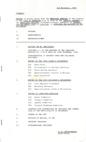 Sunshine and District Historical Society Incorporated
Administrative record - City of Sunshine - Commissioner Mr Alexander Alex George Gillon Collection 1976 - 1982 - Notice of ordinary meeting of the council 9th December 1980, City of Sunshine, 3rd December 1980
... Pauls Parish Report of the City Librarian Report of the Melton Branch Librarian Corio Street Branch Library National Conference on Multiculturalism and Libraries 8th to 11th November 1980 Report Report of the City Engineer & Planner Industrial Development Code for the City of Sunshine Planning Permit Application Sonley Street Kindergarten Maidstone Planning Permit Ground and First Floor Offices 237 & 239 - 24 Hampshire Road Sunshine Planning Permit Application Service Premises 250 McIntyre Road Sunshine North Planning Permit Application Illuminated Sky Sign Corner Glengala Road and Evelyn Crescent Sunshine West Planning Permit Application Alterations to Existing Shops Highpoint West Shopping Centre Lots 8, 9, 10, 11, 13 and Part 12 Rosamond Road Maribyrnong Planning Permit Application Four Flats 225 Main Road West St. Albans Planning Permit Bank Corner Hampshire Road and Devonshire Road Sunshine Planning Permit Application Transport Depot and Grain Store...Pauls Parish Report of the City Librarian Report of the Melton Branch Librarian Corio Street Branch Library National Conference on Multiculturalism and Libraries 8th to 11th November 1980 Report Report of the City Engineer & Planner Industrial Development Code for the City of Sunshine Planning Permit Application Sonley Street Kindergarten Maidstone Planning Permit Ground and First Floor Offices 237 & 239 - 24 Hampshire Road Sunshine Planning Permit Application Service Premises 250 McIntyre Road Sunshine North Planning Permit Application Illuminated Sky Sign Corner Glengala Road and Evelyn Crescent Sunshine West Planning Permit Application Alterations to Existing Shops Highpoint West Shopping Centre Lots 8, 9, 10, 11, 13 and Part 12 Rosamond Road Maribyrnong Planning Permit Application Four Flats 225 Main Road West St. Albans Planning Permit Bank Corner Hampshire Road and Devonshire Road Sunshine Planning Permit Application Transport Depot and Grain Store ...Notice of Ordinary Meeting of the Council 9th December 1980 Report of the Town Clerk's Department Report of the Town Clerk Kiosk Sunshine Swimming Pool Professional Indemnity Insurance Proposed Technical School for Keilor Rate Recovery Sale Lot 88 Balfour Avenue Sunshine North Deed of Release Advertising Contracts Increase in Ceiling Municipal Association Committees Nomination of Representative Proposed Closure Dobson Crescent Braybrook St. Johns College Report of Rainbow Workshop Supplementary Valuations Land Transfer 88 Station Road Deer Park Sunshine Swimming Pool Learners Pool Heating Golf Course South Side of Maribyrnong River Proposed Link with the Essendon Golf Course Sealing of General Rate Year Ending 30th September 1980 Date of Ordinary Meetings of Council Report of the Co-Ordinator of Welfare Services Purchase of Land Randall Street Maribyrnong Funding for Teenage Holiday Programmes Emergency Foster Care Family Day Care Local Youth Affairs Council's Forum International Year of the Disable Federal Government Funding of Child Care Programmes Victorian Transport Study Lonie Report Sunshine CYSS Report of the Chief Health Surveyor Authorisation of Officers Under Summary Offences Act 1966 Issuing of Septic Tank Approval Notices Application for Septic Tank Systems Subsidies for Infant Welfare Sisters Weights and Measures Practical Experience Health Act Registrations Prosecution Proceedings Sunshine Magistrates Court Health Act Registrations for 1981 Health Act Registration Late Fee Application for Transfer of Proprietorship of Premises Under the Health Act Smorgan Consolidated Industries (Paper Plant) "Black Liquor" Process Refuse By-Law Enforcement Report of the Superintendent Traffic & By-Laws Jumble Sale Albion Rovers Soccer Club Sunshine Commonwealth Offices Devonshire Road Sunshine Dog Act Court Proceedings Parking and Traffic Infringements Dog Act Authority Under Sections 695 (10) of the Local Government Act 1958 Disposal of Derelict Vehicles Proposed Procession St. Pauls Parish Report of the City Librarian Report of the Melton Branch Librarian Corio Street Branch Library National Conference on Multiculturalism and Libraries 8th to 11th November 1980 Report Report of the City Engineer & Planner Industrial Development Code for the City of Sunshine Planning Permit Application Sonley Street Kindergarten Maidstone Planning Permit Ground and First Floor Offices 237 & 239 - 24 Hampshire Road Sunshine Planning Permit Application Service Premises 250 McIntyre Road Sunshine North Planning Permit Application Illuminated Sky Sign Corner Glengala Road and Evelyn Crescent Sunshine West Planning Permit Application Alterations to Existing Shops Highpoint West Shopping Centre Lots 8, 9, 10, 11, 13 and Part 12 Rosamond Road Maribyrnong Planning Permit Application Four Flats 225 Main Road West St. Albans Planning Permit Bank Corner Hampshire Road and Devonshire Road Sunshine Planning Permit Application Transport Depot and Grain Store Francis Street Brooklyn Strata Subdivision 46 Monash Street Sunshine Strata Subdivision 53 Hertford Road Sunshine Plan of Subdivision Denton Avenue, Cavell Close and Maroondah Court St. Albans Prestressed Beam Lawrence Street Ardeer Footbridge Tenders Transfer of Reserves Westerngate Estate Installation of Fire Hydrants Transport Regulation Board Sunshine Bus Lines Pty Ltd Application to Change Route No 450 Sunshine to Ardeer St. Albans Road Footpath (East Side) Albion Station to B.T.M. Tubemakers Request by St. Albans South Progress Association Traffic Engineering Measures Accident Analysis Programme South Road Street Proposed Lighting Scheme by City of Footscray Electricity Supply Department Rochester Street to Darnley Street Braybrook Tariffs Public Lighting Sale of Surplus Equipment Appleby Avenue (Appleby Court) Private Street Scheme Boundary Road reconstruction East of Fitzgerald Road Laverton North St. Albans Heights Primary School Request for Regular Maintenance Proposed Roundabouts Northumberland Road / Suffolk Road and Northumberland Road / Warwick Road Sunshine North Air Conditioning Municipal Offices Proposed Public Toilet Block Ballarat Road Deer Park Report of the Building Surveyor Underground Tanks 199 Ballarat Road Maidstone Location of Building 63 Westmoreland Road Sunshine North Location of Building 8 Tullaroop Court St. Albans Building Over Easement 11 Jeffrey Close St. Albans Schedule for Authorising of Affixing the Common Seal of the Municipality to Documents Orders of the Day Accounts Submitted for Payment as at 30th November 1980balfour avenue, sunshine north, dobson crescent, sunshine, station road, deer park, sunshine swimming pool, kennedy street, st. johns college, essendon golf course, randall street, maribyrnong, smorgan consolidated industries, somerville road, tottenham, albion rovers soccer club, devonshire road, hampshire road, mcintyre road, glengala road, evelyn crescent, sunshine west, highpoint west shopping, rosamond road, main road west, st. albans, francis street, brooklyn, monash street, hertford road, denton avenue, cavell close, maroondah court, lawrence street, lawrence street bridge, ardeer, sunshine bus lines, st. albans road, b.t.m. tubemakers, south road, rochester street, darnley street, appleby avenue, appleby court, fitzgerald road, boundary road, st. albans heights primary school, norwich street, northumberland road, suffolk road, warwick road, ballarat road, maidstone, westmoreland road, tullaroop court, jeffrey close
