
Showing 46 items matching "farm entrance"
-
 Lakes Entrance Historical Society
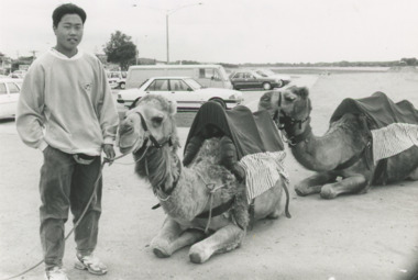
Photograph - Woodend Camel Farm Lakes Entrance Victoria, Lakes Post Newspaper, 1/12/1995 12:00:00 AM
... Woodend Camel Farm Lakes Entrance Victoria...Woodend Camel Farm Lakes Entrance Victoria...Kym Handley of Woodend Camel Farm with two camels on the sand area east of the Footbridge Lakes Entrance Victoria...Black and white photograph showing Kym Handley of Woodend Camel Farm with two camels on the sand area east of the Footbridge Lakes Entrance Victoria...Kym Handley of Woodend Camel Farm with two camels on the sand area east of the Footbridge Lakes Entrance Victoria Tourism Festival Animals Farm Black and white photograph showing Kym Handley of Woodend Camel Farm with two camels on the sand area east of the Footbridge Lakes Entrance Victoria Woodend Camel Farm Lakes Entrance Victoria Photograph Woodend Camel Farm Lakes Entrance Victoria Lakes Post Newspaper ...Kym Handley of Woodend Camel Farm with two camels on the sand area east of the Footbridge Lakes Entrance VictoriaBlack and white photograph showing Kym Handley of Woodend Camel Farm with two camels on the sand area east of the Footbridge Lakes Entrance Victoriatourism, festival, animals, farm -
 Lakes Entrance Historical Society
Photograph - Lucus's Ostrich Farm Lakes Entrance Victoria 1994, Vera Bennett
... Lucus's Ostrich Farm Lakes Entrance Victoria 1994...Gladys and Bob Lucus's Ostrich Farm Lakes Entrance Victoria...Colour photograph of Gladys Lucus with two ostriches in an enclosure on Gladys and Bob Lucus's Ostrich Farm Lakes Entrance Victoria...Gladys and Bob Lucus's Ostrich Farm Lakes Entrance Victoria Businesses Farm Commerce Colour photograph of Gladys Lucus with two ostriches in an enclosure on Gladys and Bob Lucus's Ostrich Farm Lakes Entrance Victoria Photograph Lucus's Ostrich Farm Lakes Entrance Victoria 1994 Vera Bennett ...Gladys and Bob Lucus's Ostrich Farm Lakes Entrance VictoriaColour photograph of Gladys Lucus with two ostriches in an enclosure on Gladys and Bob Lucus's Ostrich Farm Lakes Entrance Victoriabusinesses, farm, commerce -
 Nillumbik Shire Council
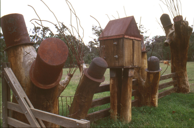
Sculpture: Tony Trembath (b.1946 Sale, Victoria), Tony Trembath, The Fences Act 1968 - Location: Edendale Farm (entrance) 30 Gastons Road, Eltham, 1989 - 1994
... The Fences Act 1968 - Location: Edendale Farm (entrance) 30 Gastons Road, Eltham...Eltham Council (now the Shire of Nillumbik) commissioned this work in 1989 to create an entrance / gateway to Edendale Community Farm. It was also aided by a grant from the Ministry of the Arts (now Arts Victoria). ...The Fences Act 1968 - Location: Edendale Farm (entrance) 30 Gastons Road, Eltham Sculpture: Tony Trembath (b.1946 Sale, Victoria) Tony Trembath ...Eltham Council (now the Shire of Nillumbik) commissioned this work in 1989 to create an entrance / gateway to Edendale Community Farm. It was also aided by a grant from the Ministry of the Arts (now Arts Victoria). The former name of this work was "Gateway to Edendale Farm". Edendale Farm is a demonstration farm modelling sustainable environmental practices, providing support to the local residents of Nillumbik. Established in 1986, the land was purchased in 1970. It was previously an English gentleman's residence and was used for grazing. It consists of 5.6 hectares, with the Diamond Creek meandering through the property. The Victorian Fences Act 1968 governs liability of occupiers of adjoining lands to fence, and deals with disputes between neighbours regarding boundaries fences and costs. This work took into consideration ideas and suggestions from residents and committees, who required the use of recycled materials and that the work celebrate man's relationship with nature, animals and the earth, as well as relate to the fence-line on the far side of the carpark. Trembath also absorbed significant aspects of local history, making references to Eltham's agricultural past, the clearing of the land, the destruction of trees, the ruthless pruning of trees by suburban Councils and incorporated such Australian features as the post and rail fence. 'The Fences Act 1968' is significant for aesthetic, historic and social reasons at a regional level. It makes prominent the historical and social significance of Edendale and the rural aspects of Nillumbik. The use of existing tree stumps and salt pots in the work explores the iconography of the countryside such as the isolated farmhouse, pioneering farming practices, post and rail fencing and the regrowth of lopped trees. The title of the work, as well as the extensive community involvement in its creation, also makes reference to the Victorian Fences Act 1968, which makes neighbours jointly responsible for the cost of construction and maintenance of fences in the partitioning of land for settlement. 'The Fences Act 1968' has been classified as of regional significance by the National Trust of Australia. The work is an installation of wood and metal, approximately twenty five meters long. The design is very informal and rustic and runs the full width of the fence-line. It comprises groups of recycled tree trunks fitted with metal caps (chrome-nickel 'salt pots' that are shaped like tall bowler / top hats). Metal rods protrude from the trunks and some of these rods have metal birds. Two larger, sentinel-like stumps at the two outer ends have metal flame-like wings, which bend inward. To the left of the entrance, a simple architectural element indicates an isolated farmhouse. The rustic fence runs between the groups of tree trunks with native planting in clumps along it. The fence-line incorporates a functional engineered double gate and post and rail fencing. There may be many interpretations of the work and the intention is to stimulate interest and imagination rather than alienate. Interpretation is based on the personal experience that a visitor brings. The artist recommended that no explanation of the design logic be positioned with the work. N/Apublic art, sculpture, edendale, recycled, wood, metal, fences act 1968, gate, trembath, salt pot, tree stumps -
 Friends of Westgarthtown
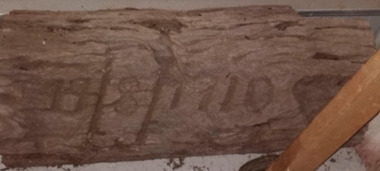
Sign - Wooden fence post sign, 1910
... ...farm entrance...The marker provides a tangible connection to the development and maintenance of the Ziebell family farm during the early twentieth century, documenting a practical tradition associated with the construction of farm entrances and boundary fencing. The marker was donated to Ziebell's Farmhouse Museum by Lyn and James Ziebell....Date marker bearing the inscription '1910', originally located on a gate post at the entrance to the Ziebell family farm at Westgarthtown, Thomastown, Victoria....Gate post date marker 1910 Joe Adams farm entrance farm infrastructure Westgarthtown Ziebell family. 19/08/1910 Date marker bearing the inscription '1910', originally located on a gate post at the entrance to the Ziebell family farm at Westgarthtown, Thomastown, Victoria. ...This date marker was originally located on a gate post at the entrance to the Ziebell family farm at Westgarthtown, Thomastown, Victoria. The inscription '1910' records the year in which the gate post was installed, reflecting a practice of marking significant improvements to the farm's infrastructure. Henry Ziebell recalled that dates were chiselled into gate posts to record when they were installed. He identified Joe Adams as having been responsible for chiselling at least one of these dates, although it is not confirmed whether he inscribed this particular example. The marker provides a tangible connection to the development and maintenance of the Ziebell family farm during the early twentieth century, documenting a practical tradition associated with the construction of farm entrances and boundary fencing. The marker was donated to Ziebell's Farmhouse Museum by Lyn and James Ziebell.Date marker bearing the inscription '1910', originally located on a gate post at the entrance to the Ziebell family farm at Westgarthtown, Thomastown, Victoria.19/08/1910gate post, date marker, 1910, joe adams, farm entrance, farm infrastructure, westgarthtown, ziebell family. -
 Lakes Entrance Historical Society
Photograph - Shirley Hancock, Golden Point Farm Hunters Lane Lakes Entrance Victoria 1994
... Shirley Hancock, Golden Point Farm Hunters Lane Lakes Entrance Victoria 1994...Colour photograph of Shirley Hancock in dining room of Golden Point Farm Hunters Lane Lakes Entrance Victoria...Genealogy Colour photograph of Shirley Hancock in dining room of Golden Point Farm Hunters Lane Lakes Entrance Victoria Photograph Shirley Hancock, Golden Point Farm Hunters Lane Lakes Entrance Victoria 1994 ...Colour photograph of Shirley Hancock in dining room of Golden Point Farm Hunters Lane Lakes Entrance Victoriagenealogy -
 Lakes Entrance Historical Society
Photograph - Brian Hancock, Golden Point Farm Hunters Lane Lakes Entrance 1994
... Brian Hancock, Golden Point Farm Hunters Lane Lakes Entrance 1994...Colour photograph of Brian Hancock taken in dining room of Golden Point Farm Hunters Lane Lakes Entrance Victoria...Genealogy Colour photograph of Brian Hancock taken in dining room of Golden Point Farm Hunters Lane Lakes Entrance Victoria Photograph Brian Hancock, Golden Point Farm Hunters Lane Lakes Entrance 1994 ...Colour photograph of Brian Hancock taken in dining room of Golden Point Farm Hunters Lane Lakes Entrance Victoriagenealogy -
 Surrey Hills Historical Society Collection
Photograph, Entrance to Wattle Park from Riversdale Road, 1912-1914
... Note: Riversdale Road becomes not much more than a track after passing the farm entrance....Note: Riversdale Road becomes not much more than a track after passing the farm entrance. wattle park 1912 farms 1914 fenwicks farm fennies fences trees roads and streets riversdale road pine trees gum trees cyclists A dirt road in the lower left corner of the photograph is bounded by a post and rail fence. ...Information provided by Stan Smith: Riversdale Road looking east 1912-1914. Wattle Park, then a farm is on the right. The near row of trees across the picture, indicates the driveway in Wattle Park. Wattle Park was then Fenwick's farm - or - Fennies to the local boys. Note: Riversdale Road becomes not much more than a track after passing the farm entrance.A dirt road in the lower left corner of the photograph is bounded by a post and rail fence. Two cyclists are on the road. "Wattle Park" is written to the right side of the road.wattle park, 1912, farms, 1914, fenwicks farm, fennies, fences, trees, roads and streets, riversdale road, pine trees, gum trees, cyclists -
 Lakes Entrance Historical Society
Photograph - Bob Hodgson, Melbourne Showground 'Exhibition Farm Sunday', Lakes Post Newspaper, 1/09/1991 12:00:00 AM
... pioneer craft models made by Bob Hodgson to demonstrate early building techniques to go to Melbourne Showground Exhibition Farm Lakes Entrance Victoria...Black and white photograph of Bob Hodgson of Lakes Entrance Victoria to demonstrate early building techniques to go to Melbourne Showground 'Exhibition Farm Sunday' ...pioneer craft models made by Bob Hodgson to demonstrate early building techniques to go to Melbourne Showground Exhibition Farm Lakes Entrance Victoria Arts People Arts and crafts Black and white photograph of Bob Hodgson of Lakes Entrance Victoria to demonstrate early building techniques to go to Melbourne Showground 'Exhibition Farm Sunday' Photograph Bob Hodgson, Melbourne Showground 'Exhibition Farm Sunday' Lakes Post Newspaper ...pioneer craft models made by Bob Hodgson to demonstrate early building techniques to go to Melbourne Showground Exhibition Farm Lakes Entrance VictoriaBlack and white photograph of Bob Hodgson of Lakes Entrance Victoria to demonstrate early building techniques to go to Melbourne Showground 'Exhibition Farm Sunday' arts, people, arts and crafts -
 Lakes Entrance Historical Society
Album, LERHS members, Lakes Entrance Historical Society Day Trips, 2006
... Photograph album containing photographs taken during Lakes Entrance Historical Society members visit to Campbells farm Lakes Entrance, Buchan and Beasleys home Lindenow Victoria. ...Celebrations Township Photograph album containing photographs taken during Lakes Entrance Historical Society members visit to Campbells farm Lakes Entrance, Buchan and Beasleys home Lindenow Victoria. ...Photograph album containing photographs taken during Lakes Entrance Historical Society members visit to Campbells farm Lakes Entrance, Buchan and Beasleys home Lindenow Victoria. Please visit History Centre to view all photos in this Album. celebrations, township -
 Flagstaff Hill Maritime Museum and Village
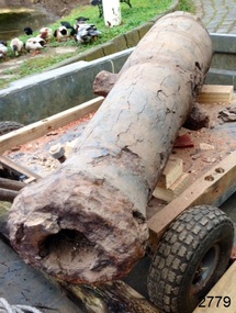
Weapon - Cannon, circa 1825
... entrance to the cove. The seas smashed it into pieces within twenty minutes. The bodies of sixteen of those who had lost their lives were spread across the shore, along with wreckage from the ship and the cargo of animals. Those who survived suffered injuries; they were rescued and taken by horse and cart to Campbell’s farm...entrance to the cove. The seas smashed it into pieces within twenty minutes. The bodies of sixteen of those who had lost their lives were spread across the shore, along with wreckage from the ship and the cargo of animals. Those who survived suffered injuries; they were rescued and taken by horse and cart to Campbell’s farm ...In an article dated 26 March 1963, the Warrnambool Standard reported: “A cannon which has lain on the ocean floor since the barque, Children, was wrecked at Childer’s Cove on January 15, 1839, was raised by three Warrnambool skindivers at the weekend … The cannon, weighing about 750 lb. and 4-ft. 6-in. in length … is in excellent order considering the length of time it has remained underwater”. No conservation measures were taken at that time, other than chipping off the marine growth with hammers and cold chisels. The minutes for the 4 February 1974 meeting of the Flagstaff Hill Planning Board recorded that “a cannon recovered some time ago was lying in the garden of [one of the three original divers] and that it could be picked up at any time”. Peter Ronald, past Manager and Diver for Flagstaff Hill, notes that the CHILDREN cannon would have been recovered by the other divers around 1964. When the cannon came into care of Flagstaff Hill, it was given basic conservation relevant to the time. (At the same meeting, the Board was advised of the recovery of an anchor from the wreck of the CHILDREN by Flagstaff Hill divers (Peter Ronald, Colin Goodall and Gary Hayden, and Hank Howey and Andrew Coffee), and its interim relocation in the sea at the end of the Warrnambool Breakwater while awaiting conservation). About the ship CHILDREN 1825-1839: The sailing ship Children was a wooden, three-masted barque constructed of pitch pine in 1825 at Liverpool. It was felt sheathed and was coppered during an upgrade in 1837. The ship was only 29 metres long and 254 tons in weight; it had two decks and a square stern. The James Henty & Co., a pioneering family from Portland, Victoria, purchased the Children in 1837 for use as a coastal trader. The Children, under the command of Captain H. Browne, was on a voyage from Launceston to Adelaide when it foundered in rough conditions at Childers Cove, west of Peterborough, on 14 January 1839. On board were 14 crew members and 24 passengers, including 9 children. The ship’s cargo was awkwardly balanced: it carried 1500 sheep, 8 bullocks, 7 horses, 5000 London house bricks, 6 whaling boats with associated gear, and general trade goods including beef, pork, tobacco, tipe, butter, lime juice, horse hair, curtains, lead shot, beer and spirits. The hurricane-force winds drove the Children into the limestone stack at the entrance to the cove. The seas smashed it into pieces within twenty minutes. The bodies of sixteen of those who had lost their lives were spread across the shore, along with wreckage from the ship and the cargo of animals. Those who survived suffered injuries; they were rescued and taken by horse and cart to Campbell’s farm, near the whaling station at Port Fairy. They arrived at Portland eleven days after the wreck. The wrecking of the Children is one of colonial Victoria’s earliest and most significant maritime disasters. Little is left to mark the tragedy, apart from some house bricks intended for the Henty family’s Portland Bay settlement. Artefacts recovered in the 1960s to early 1970s include this signal cannon, an anchor, the bottom half of her ship’s bell, and two portions of a ship’s fitting, at one time thought to be a brass porthole frame, London housing bricks and timber flooring. Despite its poor condition, the CHILDREN’s signal cannon remains an important and interpretable record of its demise. From 2015, the CHILDREN cannon has been undergoing the first stages of further conservation.The signal cannon recovered from the Children's wreck is significant as part of the original fittings of the early 19th-century barque. It is an example of maritime defence in the early to mid-19th century. The 1839 wreck and recovered artefacts are examples of the construction methods and materials used in that era and can be used to study the evolution of shipbuilding methods and principles. The wreck of the Children is of state significance as one of colonial Victoria’s earliest and most significant maritime disasters, and one of the first vessels lost in the Western District. This is recognised by its inclusion on the Victorian Heritage Register, VHR No. S116. Little is left on the seabed to mark the tragedy, apart from some of the house bricks intended for the Henty settlement. Signal cannon: a 1.3 metre iron 6pdr cannon recovered from the wreck of the CHILDREN. The shape of the cannon tapers from a thick round breech to a flared muzzle, with an 8-centimetre bore, and two side trunnions for pivoting on a wooden gun carriage. It was recovered from the shipwreck site of the CHILDREN by local divers in 1963. This small muzzle-loading signal cannon is in poor and unrestored condition. The cannon’s upper profile of smooth grey metal casing has corroded off, leaving an extensively oxidised rough red surface of crumbling iron. The bottom half of the cannon remains intact, although the outer smooth casing also appears to be separating from the iron core of the barrel. The original grey casting is also missing from the breech and muzzle ends of the cannon. Corrosion and spalling of the upper surface layer of the cannon have removed the maker’s marks and specificationsflagstaff hill, flagstaff hill maritime museum and village, warrnambool, maritime museum, maritime village, great ocean road, shipwreck coast, shipwreck artefact, children, barque, three-masted, liverpool, childer’s cove, port campbell, 1839 shipwreck, 1939 wreck, james henty and co, henty brothers, captain h. browne, first mate t. gay, second mate w. wentworth, portland, portland bay, 1939, ship’s cannon, signal cannon, conservation of marine artefacts, 6pdr small bore cannon, defence -
 Marysville & District Historical Society
Photograph (Item) - Colour photograph, Unknown
... A colour photograph of the entrance sign for Hazelwood Farm at Buxton in Victoria....A colour photograph of the entrance sign for Hazelwood Farm at Buxton in Victoria....A colour photograph of the entrance sign for Hazelwood Farm at Buxton in Victoria. A colour photograph of the entrance sign for Hazelwood Farm at Buxton in Victoria. buxton victoria hazelwood farm hazelnut A colour photograph of the entrance sign for Hazelwood Farm at Buxton in Victoria. ...A colour photograph of the entrance sign for Hazelwood Farm at Buxton in Victoria.A colour photograph of the entrance sign for Hazelwood Farm at Buxton in Victoria.buxton, victoria, hazelwood farm, hazelnut -
 Orbost & District Historical Society
black and white photograph, 1911
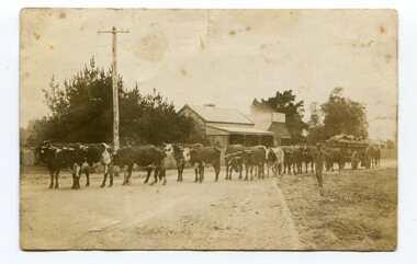
... Entrance for transhipment to the Melbourne market. At that .time yields of 90 to 100 bushels of maize were quite a common occurrence. James Lynn, a member of the East Gippsland Maize Board, farmed at Jarrahmond....Entrance for transhipment to the Melbourne market. At that .time yields of 90 to 100 bushels of maize were quite a common occurrence. James Lynn, a member of the East Gippsland Maize Board, farmed at Jarrahmond. ...This photo shows Jas Lynn of Orbost driving a team of bullocks pulling a large cart of maize. They are taking it to the fisherman's Wharf in Lakes Entrance. Maize has been grown on the Orbost flats since the late 19th century. Transport was always an obstacle to economic sucess. For a few years prior to the First World War and the construction of the railway line from Bairnsdale to Orbost, a lot of maize was carted by horse and bullock teams to Lakes Entrance for transhipment to the Melbourne market. At that .time yields of 90 to 100 bushels of maize were quite a common occurrence. James Lynn, a member of the East Gippsland Maize Board, farmed at Jarrahmond.This photograph is associated with the large maize growing industry in the Orbost region. A black / white photograph of a bullock team pulling a large, loaded cart. It is being driven by a man standing on the side of the road, holding a whip. In the background are houses and a telegraph pole.on back - " Carting maize to Lakes Entrance in 1911."transport-bullocks maize-orbost lynn-james -
 Orbost & District Historical Society
black and white photograph, Vogt, Stanley, 1918
... Entrance, and then by ocean boats to Melbourne. Later it was taken to Bairnsdale by foot and loaded onto the trains to Melbourne. (more information in Newsletter October 2006) This crib, measuring seven chains, sixteen feet, contained 10,000 bags of maize cobs which were grown by Linc Timmons on Peter Irvine's farm (Fairlea?) ...Entrance, and then by ocean boats to Melbourne. Later it was taken to Bairnsdale by foot and loaded onto the trains to Melbourne. (more information in Newsletter October 2006) This crib, measuring seven chains, sixteen feet, contained 10,000 bags of maize cobs which were grown by Linc Timmons on Peter Irvine's farm (Fairlea?) ...Maize,has been grown on the Orbost flats for at least 70 years. When early settlers began to arrive on the Snowy River somewhere in the 1880s, the land was mostly swamps and heavily timbered jungle on the river frontages. The swamps were drained, bit by bit, by men with short handled shovels and working in mud and water. The frontages were cleared by axe and shovel and fire. Several kinds of crops were experimented with such as hops, hemp and maize, the latter grew particularly well and became the main crop of district. The problem then was to thresh and deliver the product to the market. A small single cob machine was brought here and one man turned the handle, while the boy or Mum fed the cobs singly into the machine. A good day’s work would thresh about 50 bushels or about 12 bags (4 bushels). The task then was to cart the maize to market. For a few years this was done by horses and dray carrying about 60 bushels to Mossiface, where it was loaded onto river boats to Lakes Entrance, and then by ocean boats to Melbourne. Later it was taken to Bairnsdale by foot and loaded onto the trains to Melbourne. (more information in Newsletter October 2006) This crib, measuring seven chains, sixteen feet, contained 10,000 bags of maize cobs which were grown by Linc Timmons on Peter Irvine's farm (Fairlea?) in Orbost, East Gippsland. The growing of maize in the Orbost district contributed significantly to the economy of the township for many years, The many maize cribs once seen on the surrounding farms have now disappeared and this photograph is a pictorial record of that significance.A black / white photograph of a large maize crib full of maize in a paddock. There is a large framed copy of the original.agriculture-orbost farming-maize-orbost maize-crib-orbost -
 Orbost & District Historical Society
black and white photograph
... Entrance, and then by ocean boats to Melbourne. Later it was taken to Bairnsdale by foot and loaded onto the trains to Melbourne. (more information in Newsletter October 2006) The growing of maize in the Orbost district contributed significantly to the economy of the township for many years, The many maize cribs once seen on the surrounding farms have now disappeared and this photograph is a pictorial record of that significance. maize-crib-Orbost agriculture maize-corn-Orbost A black / white photograph of a man unloading maize from a horse-drawn wagon into a maize crib. ...Maize,has been grown on the Orbost flats for at least 70 years. When early settlers began to arrive on the Snowy River somewhere in the 1880s, the land was mostly swamps and heavily timbered jungle on the river frontages. The swamps were drained, bit by bit, by men with short handled shovels and working in mud and water. The frontages were cleared by axe and shovel and fire. Several kinds of crops were experimented with such as hops, hemp and maize, the latter grew particularly well and became the main crop of district. The problem then was to thresh and deliver the product to the market. A small single cob machine was brought here and one man turned the handle, while the boy or Mum fed the cobs singly into the machine. A good day’s work would thresh about 50 bushels or about 12 bags (4 bushels). The task then was to cart the maize to market. For a few years this was done by horses and dray carrying about 60 bushels to Mossiface, where it was loaded onto river boats to Lakes Entrance, and then by ocean boats to Melbourne. Later it was taken to Bairnsdale by foot and loaded onto the trains to Melbourne. (more information in Newsletter October 2006)The growing of maize in the Orbost district contributed significantly to the economy of the township for many years, The many maize cribs once seen on the surrounding farms have now disappeared and this photograph is a pictorial record of that significance.A black / white photograph of a man unloading maize from a horse-drawn wagon into a maize crib. Another man is standing by the horse.maize-crib-orbost agriculture maize-corn-orbost -
 Phillip Island and District Historical Society Inc.
Photograph Album, Kodak, Phillip Island Cemetery, c 1990
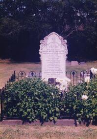
... entrance. phillip island cemetery nancy mchaffie edith jeffery captain john barnard lock david charles justice isabella justice 466-34: Captain J. B. Lock. John Barnard Lock was associated with the trading vessels to operate from Phillip Island when the settlers had most of their goods brought from Melbourne. He died in 1908 and is laid to rest in the family grave. The grave is surrounded by metal railing and flowers. 466-35: David Charles Justice. David came to the Island in 1898. He was a blacksmith, coachbuilder, farrier, agricultural engineer, wheelmaker, shipbuilder and farmer. He purchased a farm ...The Album was compiled by Nancy McHaffie late 1990's, with the assistance of Edith Jeffery's, with her book "Garden of Memories" and extensive knowledge of Phillip Island. The Cemetery lies back from the road and is surrounded by Manna Gums, rare Peppermint Gums, Blackwoods and other native trees. In all 25 acres of land were set aside as Crown Land in the land settlement of 1868. There are 6.2 acres of wetlands near the cemetery entrance.466-34: Captain J. B. Lock. John Barnard Lock was associated with the trading vessels to operate from Phillip Island when the settlers had most of their goods brought from Melbourne. He died in 1908 and is laid to rest in the family grave. The grave is surrounded by metal railing and flowers. 466-35: David Charles Justice. David came to the Island in 1898. He was a blacksmith, coachbuilder, farrier, agricultural engineer, wheelmaker, shipbuilder and farmer. He purchased a farm from the Harbison Estate in 1911 in the Ventnor township. He assisted Mr Will Kennon in building a punt used to recover equipment from the wreck of the "Speke". "Dinny" as he was called, married Isabella Miller (an early settlers' family). He died in November 1943 aged 79. Isabella died in October 1936 aged 86. phillip island cemetery, nancy mchaffie, edith jeffery, captain john barnard lock, david charles justice, isabella justice -
 Phillip Island and District Historical Society Inc.
Photograph Album, Kodak, Phillip Island Cemetery, c 1990
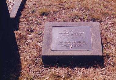
... entrance. Phillip Island Cemetery Malcolm Sutherland Jessie Watson nee McGregor Nancy McHaffie Edith Jeffery 466-36: Jessie Watson was a daughter of the McGregor family who came to the Island in the very early days. Their selection was one of the most exposed areas on the Island. Jessie was married for a brief period and continued, with her brother Charlie, to work the family farm ...The Album was compiled by Nancy McHaffie late 1990's, with the assistance of Edith Jeffery's, with her book "Garden of Memories" and extensive knowledge of Phillip Island. The Cemetery lies back from the road and is surrounded by Manna Gums, rare Peppermint Gums, Blackwoods and other native trees. In all 25 acres of land were set aside as Crown Land in the land settlement of 1868. There are 6.2 acres of wetlands near the cemetery entrance.466-36: Jessie Watson was a daughter of the McGregor family who came to the Island in the very early days. Their selection was one of the most exposed areas on the Island. Jessie was married for a brief period and continued, with her brother Charlie, to work the family farm. Jessie was a hard worker and died in 1963 aged 98. The Plaque on her grave was donated by the Phillip island & District Historical Society. 466-37: Malcolm Sutherland. Malcolm died age 8 years while on a holiday on Phillip Island. His father was Dr. Alexander Sutherland who conducted his own school "Carlton College" Melbourne. Dr Sutherland was also appointed to the Melbourne Public Library committee for the papers taken to England by Governor La Trobe in May 1894. Malcolm was the only son of Alexander & Lizzie Sutherland.phillip island cemetery, malcolm sutherland, jessie watson nee mcgregor, nancy mchaffie, edith jeffery -
 Phillip Island and District Historical Society Inc.
Photograph Album, Kodak, Phillip Island Cemetery, c 1990
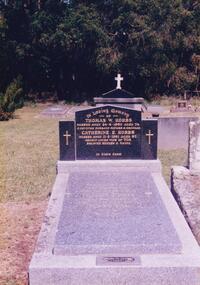
... entrance. Phillip Island Cemetery Cr. Hobbs Matilda Richardson Grave Nancy McHaffie Edith Jeffery 466-42: Thomas William Hobbs BEM. Thomas was born in England and came to the Island in the 1920's to work for the Chicory Farmers. He later owned his own farm ...The Album was compiled by Nancy McHaffie late 1990's, with the assistance of Edith Jeffery's, with her book "Garden of Memories" and extensive knowledge of Phillip Island. The Cemetery lies back from the road and is surrounded by Manna Gums, rare Peppermint Gums, Blackwoods and other native trees. In all 25 acres of land were set aside as Crown Land in the land settlement of 1868. There are 6.2 acres of wetlands near the cemetery entrance.466-42: Thomas William Hobbs BEM. Thomas was born in England and came to the Island in the 1920's to work for the Chicory Farmers. He later owned his own farm at Ventnor and won the Better Farming Competition conducted by the Phillip Island Council. He was always an active community worker. Thomas was a Councillor and served two terms as President. He was the only resident to be awarded the British Empire Medal, Civil Division, for services to Phillip Island. Thomas died 1980 aged 75. His wife Catherine died 1991 aged 87. 466-43: Matilda Richardson. Matilda was born at Kyneton on 12th July 1865 and came to Cowes with her parents in 1869. She attended Cowes Primary School with her brothers and sisters. She became ill in November 1872 and died on 10th February 1873 aged 8 years and 7 months, from a severe bout of Quinsy. It was a great sadness to the family and they went to a lot of trouble to secure Matilda a fine grave in the cemetery. It is the oldest grave in the cemetery and a lasting memorial for her short life.phillip island cemetery, cr. hobbs, matilda richardson grave, nancy mchaffie, edith jeffery -
 Phillip Island and District Historical Society Inc.
Photograph Album, Kodak, Phillip Island Cemetery, c 1990
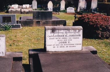
... entrance. Phillip Island Cemetery Johan Jansson Evelyn Jansson Mavis Jansson Nancy McHaffie Edith Jeffery 466-44: Captain Johan Jansson. Capatain Jansson was born in 1862 and came to Australia on the ship "Nosstaljee" in 1886. In 1887 he came to the Island and started work with Captain Lock. He bought land at Rhyll in 1891 and built a house two years later, now known as Jansson's Cottage. Johan married Evelyn Power.. a daughter of Captain Powell. He purchased the ketch "Swan" and later :Stephen" in 1914. They took chicory, seaweed, hay and other farm ...The Album was compiled by Nancy McHaffie late 1990's, with the assistance of Edith Jeffery's, with her book "Garden of Memories" and extensive knowledge of Phillip Island. The Cemetery lies back from the road and is surrounded by Manna Gums, rare Peppermint Gums, Blackwoods and other native trees. In all 25 acres of land were set aside as Crown Land in the land settlement of 1868. There are 6.2 acres of wetlands near the cemetery entrance.466-44: Captain Johan Jansson. Capatain Jansson was born in 1862 and came to Australia on the ship "Nosstaljee" in 1886. In 1887 he came to the Island and started work with Captain Lock. He bought land at Rhyll in 1891 and built a house two years later, now known as Jansson's Cottage. Johan married Evelyn Power.. a daughter of Captain Powell. He purchased the ketch "Swan" and later :Stephen" in 1914. They took chicory, seaweed, hay and other farm produce to Melbourne, returning with general cargo. Captain Jansson died in 1928 aged 66 years. 466-45: Evelyn Jansson. Evelyn was the daughter of Captain Powell. She married Johan Jansson on her 18th birthday. She died 1971 aged 95 years. Their daughter Mavis is buried with Evelyn - died 1971 aged 72 years.phillip island cemetery, johan jansson, evelyn jansson, mavis jansson, nancy mchaffie, edith jeffery -
 Phillip Island and District Historical Society Inc.
Photograph Album, Kodak, Phillip Island Cemetery, c 1990
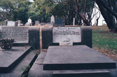
... entrance. phillip island cemetery william jenner elsie jenner nancy mchaffie edith jeffery Two photos: a) Two graves - William Jenner & Elsie Myra Jenner. William died Oct 1957 aged 73 and Elsie died April 1968 aged 82. - William Raymond Jenner - son of William & Elsie - died Oct 1951 aged 42 years. b) Close up of William & Elsie grave. William had a farm ...The Album was compiled by Nancy McHaffie late 1990's, with the assistance of Edith Jeffery's, with her book "Garden of Memories" and extensive knowledge of Phillip Island. The Cemetery lies back from the road and is surrounded by Manna Gums, rare Peppermint Gums, Blackwoods and other native trees. In all 25 acres of land were set aside as Crown Land in the land settlement of 1868. There are 6.2 acres of wetlands near the cemetery entrance.Two photos: a) Two graves - William Jenner & Elsie Myra Jenner. William died Oct 1957 aged 73 and Elsie died April 1968 aged 82. - William Raymond Jenner - son of William & Elsie - died Oct 1951 aged 42 years. b) Close up of William & Elsie grave. William had a farm at Ventnor, grew onions and chicory and was always willing to help out or lend any farming machinery. William was a member of the Ventnor School committee and Ventnor Hall committee. He was married to Elsie Churchill of Kilcunda and they had five children.phillip island cemetery, william jenner, elsie jenner, nancy mchaffie, edith jeffery -
 Orbost & District Historical Society
Photograph, 1930s
... Entrance, and then by ocean boats to Melbourne. (information from NEWSLETTER OCTOBER, 2006) The growing of maize in the Orbost district contributed significantly to the economy of the township for many years, The many maize cribs once seen on the surrounding farms have now disappeared and this photograph is a pictorial record of that significance. maize-Orbost agriculture-maize industry "on back - "Thrashing Maize" A small sepia photograph with six men in front of a wooden barn. ...Maize has been grown on the Orbost flats for at least 70 years. When early settlers began to arrive on the Snowy River somewhere in the 1880s, the land was mostly swamps and heavily timbered jungle on the river frontages. The swamps were drained, bit by bit, with short handled shovels working in mud and water. The frontages were cleared by axe and shovel and fire. Several kinds of crops were experimented with such as hops, hemp and maize which grew particularly well and became the main crop of district. The problem then was to thresh and deliver the product to the market. A small single cob machine was brought here and one man turned the handle, while the boy or Mum fed the cobs singly into the machine. A good day’s work would thresh about 50 bushels or about 12 bags (4 bushels). The task then was to cart the maize to market. For a few years this was done by horses and dray carrying about 60 bushels to Mossiface, where it was loaded onto river boats to Lakes Entrance, and then by ocean boats to Melbourne. (information from NEWSLETTER OCTOBER, 2006)The growing of maize in the Orbost district contributed significantly to the economy of the township for many years, The many maize cribs once seen on the surrounding farms have now disappeared and this photograph is a pictorial record of that significance.A small sepia photograph with six men in front of a wooden barn. They are bagging maize. In the foreground are two rows of filled bags. On the right is a lifting machine to take the bags to the top storey. On the far right is a water tank on a stand"on back - "Thrashing Maize"maize-orbost agriculture-maize industry -
 Eltham District Historical Society Inc
Negative - Photograph, Harry Gilham, Entrance Sign, Edendale Farm Community Environment Centre, Gastons Road, Eltham, 1 Aug 2007
... Entrance Sign, Edendale Farm Community Environment Centre, Gastons Road, Eltham...Edendale Community Farm Signs 35mm colour negative Kodak Gold GC 400-9 6 film strips, 1 of 25 frames Entrance Sign, Edendale Farm Community Environment Centre, Gastons Road, Eltham Negative Photograph Harry Gilham ...edendale community farm, signs -
 Eltham District Historical Society Inc
Photograph, Fay Bridge, Remains of apple orchard near the Diamond Creek, Wattle Glen, 11 October 2018
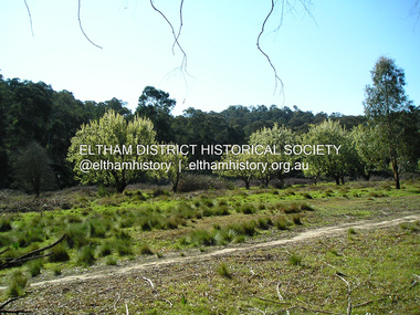
... The newly constructed Diamond Creek Trail from Diamond Creek to Wattle Glen completed in February 2021 winds past these apple trees that possibly lined the entrance to the Greenhills property From Jean Verso, Nillumbik Historical Society, 15 April 2021 William Wandless Herbert bought the surrounding 100 acres in 1852. He was a native of Northumberland and the Scottish Borders who arrived in Melbourne in 1847. The house on the top of the mound would have been built not long after he bought the land; the farm...The newly constructed Diamond Creek Trail from Diamond Creek to Wattle Glen completed in February 2021 winds past these apple trees that possibly lined the entrance to the Greenhills property From Jean Verso, Nillumbik Historical Society, 15 April 2021 William Wandless Herbert bought the surrounding 100 acres in 1852. He was a native of Northumberland and the Scottish Borders who arrived in Melbourne in 1847. The house on the top of the mound would have been built not long after he bought the land; the farm ...The newly constructed Diamond Creek Trail from Diamond Creek to Wattle Glen completed in February 2021 winds past these apple trees that possibly lined the entrance to the Greenhills property From Jean Verso, Nillumbik Historical Society, 15 April 2021 William Wandless Herbert bought the surrounding 100 acres in 1852. He was a native of Northumberland and the Scottish Borders who arrived in Melbourne in 1847. The house on the top of the mound would have been built not long after he bought the land; the farm was named "Greenhills". He married Elizabeth Wilson, daughter of John Wilson who had been in Diamond Creek since about 1846. Their first child was born in 1854 so there would be some form of dwelling from about that time. They had eight children who all survived to a good age. His will describes the house as part stone and part wood and of four rooms. Nillumbik Historical Society (NHS) believe it was one of the earliest if not the earliest house, in this part of the district. The remains of the stone house foundations are on top of the mound (photos on the VHD page) and the barn walls are on the north and to the east side of the mound. NHS is not sure how much or which part of the surrounding area was covered by the barns but they were large enough to hold dances after the race meetings that were held in the late 1880's on the adjacent creek flats. It would make sense with the lay of the land that they covered some of the ground to the north and east and used for farm storage, packing sheds for their apple and pear orchards and also for supporting the Nillumbik Gold Mine the family worked to the north up the gully. The path that comes down the gully and runs into the trail goes past the mine site which was on the west side of the gully a couple of hundred metres up from the flats. Heritage Victoria link for the site - https://vhd.heritagecouncil.vic.gov.au/places/12203fay bridge collection, 2018-10-11, diamond creek, diamond creek trail, elizabeth wilson, greenhills, wattle glen, william wandless herbert, apple trees -
 Eltham District Historical Society Inc
Album - Photograph, J.A. McDonald, Eltham-Diamond Creek Road, 21 Oct. 1953
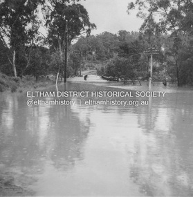
... Prior to the Wattletree Road bridge being built, Railway Parade extended up the alignment of present-day Gastons Road to the Eltham-Diamond Creek road which ran past the entrance of the present-day carpark for Edendale Farm. This view is looking west across the Glen Park Bridge, and the beginning of Wattletree Road which sweeps around to the right in the distance. ...Prior to the Wattletree Road bridge being built, Railway Parade extended up the alignment of present-day Gastons Road to the Eltham-Diamond Creek road which ran past the entrance of the present-day carpark for Edendale Farm. This view is looking west across the Glen Park Bridge, and the beginning of Wattletree Road which sweeps around to the right in the distance. ...18 October 1956 Flood level on road at corner of Railway Parade. On the immediate left out of view is Mrs Lucy Egan's home. That house still stands today nestled up against the Wattletree Road Bridge on the other side built in 1959 and is owned by the Bakos family purchased by Mrs Heather Bakos in 1960.. Prior to the Wattletree Road bridge being built, Railway Parade extended up the alignment of present-day Gastons Road to the Eltham-Diamond Creek road which ran past the entrance of the present-day carpark for Edendale Farm. This view is looking west across the Glen Park Bridge, and the beginning of Wattletree Road which sweeps around to the right in the distance. Progress Road does not exist though a road reserve is present on maps.Record of various Shire of Eltham infrastructure works undertaken during the period of 1952-1962 involving bridge and road reconstruction projects, sometimes with Eltham Shire Council Project Reference numbers quoted. It was during this period that a number of significant improvements were made to roads and new bridges constructed within the shire that remain in place as of present day (2022). In many situations, the photos provide a tangible visible record of infrastructure that existed throughout the early days of the Shire. The album was put together by or under the direction of the Shire Engineer, J.A. McDonald.infrastructure, road construction, shire of eltham, bridge construction, eltham north, floods, floodwater, glen park bridge, 1956-10-18, diamond creek (creek), eltham, railway parade, wattletree road, wattletree road bridge, gastons road -
 Eltham District Historical Society Inc
Photograph - Digital Photograph, Alan King, Edendale Farm Homestead, 29 January 2008
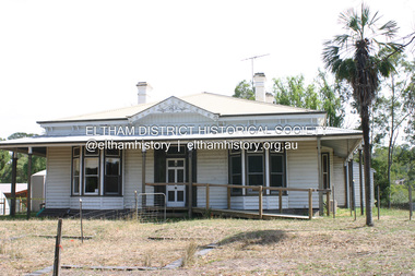
... At the entrance to the 5.6ha Edendale Farm is another surprise. A work of art that looks like huge tree trunks transformed into bowler and top-hatted men. ...At the entrance to the 5.6ha Edendale Farm is another surprise. A work of art that looks like huge tree trunks transformed into bowler and top-hatted men. ...Edendale Farm is Nillumbik Shire Council's environment centre situated in Gastons Road, Eltham between the railway and the Diamond Creek. The homestead on the property was built in 1896 and is of historical significance, being the subject of a Heritage Overlay under the Nillumbik Planning Scheme. The Edendale property was originally part of an extensive land purchase in 1852 from the Crown by pioneer Eltham farmer Henry Stooke. He initially purchased 51 acres and later expanded his holdings by purchasing another three adjacent Crown allotments extending northerly from Josiah Holloway's Little Eltham subdivision. Despite clearing the land, Stooke did not build on this property, choosing to live on his property "Rosehill" at Lower Plenty. In 1896 Thomas Cool, Club Manager of the Victoria Coffee Palace in Melbourne purchased 7 acres of the original Stooke land and built the house now known as Edendale. Cool did not farm the land, instead using it as a gentleman’s residence, retiring to Eltham at weekends. In 1918 he purchased an additional 7 acres but in 1919 he sold the property. Later owners included J.W. Cox, the Gaston family and D. Mummery. In the 1980s the Eltham Shire Council purchased the site for use as a Council depot, but this use did not proceed. Subsequently, it was used as the Council pound. The Edendale Farm Pet Education and Retention Centre was established in the summer of 1988/1989 and was set up to replace the existing dog kennels with a high standard pet retention centre. The design style of the building was established to compliment the features of the existing house. It was equipped with 10 retention pens, a veterinary room and a pet education area where school children and other interested parties learnt about pet care procedures. It was later developed into a community farm and was run by an advisory committee and in 2000 it became an Environment Centre. In early 2006 an advisory committee was established for the development of a master plan for future development at Edendale Farm. The committee included Russell Yeoman, a former long-time shire planner and founding member of the Eltham District Historical Society. At the time of filming the Master Plan and future for Edendale was about continuing to develop Edendale as a centre of environment learning and looking at expanding displays and school program, running a lot more of life-long learning and workshops around sustainable living. Covered under Heritage Overlay, Nillumbik Planning Scheme. Published: Nillumbik Now and Then / Marguerite Marshall 2008; photographs Alan King with Marguerite Marshall.; p101 A sharp turn from busy Wattletree Road by the railway line, brings a surprise. Only 1.4 km from Eltham’s centre, sheep feed, blissfully unaware of the hectic suburban activity so close by. At the entrance to the 5.6ha Edendale Farm is another surprise. A work of art that looks like huge tree trunks transformed into bowler and top-hatted men. The Fences Act 1968 by Tony Trembath with Mark Cain and John Doyle, 1996, is classified by the National Trust of Australia as having Regional Significance. The title refers to a government act on disputes between neighbors over the placement of fences and boundaries. This takes a ‘wry swipe’ at a community divided by trivial squabbles. It also celebrates making do with limited resources.1 Further along on the left, the office wall is decorated with a massive Eltham Copper Butterfly, designed by Robert Tickner and made by school children with used plastic bottles and other waste material. Nillumbik Council runs Edendale as an Environmental Education Centre, to help preserve and enhance the local environment. As early as 1988 the former Eltham Shire Council realised Edendale’s importance in meeting people’s needs, particularly of children, to enjoy farmland. The centre, with the Eltham North Reserve to the north - including remnant bushland and open parkland - makes up the major part of the public open space for this area. The council considers this area will become increasingly important to the local community for recreational use.2 Educational programs aim to encourage community involvement to ensure the long-term rehabilitation and protection of natural bushland areas. Edendale is used by people of all ages - from school children to adults - for environmental programs and workshops, as well as for recreation, to enjoy the domestic animals and to picnic. Edendale is also home to the Environmental Works staff who manage reserves and roadsides and support Nillumbik Friends environmental groups. The Friends propagate plants at the nursery, which grows indigenous plants and sells these to the public.3 The centre demonstrates the sustainable living the farm teaches, with features like solar hot water and drive lighting and for the fireplace, logs of recycled cardboard. Edendale has had a varied history as a dog pound and even as a retreat for Thomas Cool, Club Manager of the Victoria Coffee Palace in Melbourne. His single-storey weatherboard house built in 1896, which still stands, was grander than most homes in Eltham. Although such buildings were common in many other parts of Melbourne, Eltham’s poverty and remoteness did not encourage such construction. The Victorian rectangular-shaped house, with a corrugated iron roof and veranda, has elegant large rooms, leadlight windows, ceiling roses, two bay windows and ornately carved wooden fireplace surrounds. Cool bought seven acres (2.8ha) from pioneer Eltham farmer Henry Stooke’s 200 acre (81ha) farm, which he had bought from the Crown in 1852. In 1918 Cool bought an extra seven acres (2.8ha) but in 1919 sold the estate to farmer John Cox. In 1933 Cox sold Edendale to Mrs Elizabeth Gaston, after whom the road leading to the centre was named. The property was owned by several Gaston family members, who called it Edendale, then by a police constable, Douglas Mummery, until the Shire of Eltham bought it in 1970. Oddly Edendale was known as Mummery’s for almost 20 years, although Mummery owned it only for a short time.4 The shire used Edendale as a dog pound until amalgamation with other municipalities in 1996. The pound then moved to the Yan Yean Road, Plenty site, which had been used by the former Diamond Valley Shire Council. To the west and north the centre is bounded by Diamond Creek and on the east by the Melbourne-Hurstbridge railway line. Part of the Research creek forms the centre’s southern boundary.This collection of almost 130 photos about places and people within the Shire of Nillumbik, an urban and rural municipality in Melbourne's north, contributes to an understanding of the history of the Shire. Published in 2008 immediately prior to the Black Saturday bushfires of February 7, 2009, it documents sites that were impacted, and in some cases destroyed by the fires. It includes photographs taken especially for the publication, creating a unique time capsule representing the Shire in the early 21st century. It remains the most recent comprehenesive publication devoted to the Shire's history connecting local residents to the past. nillumbik now and then (marshall-king) collection, edendale farm -
 Eltham District Historical Society Inc
Photograph - Digital Photograph, Marguerite Marshall, Smith Dam, Karingal Drive, Eltham, 19 September 2006
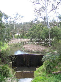
... entrance to the Nerreman Gateway in Eltham was built according to an internationally acclaimed theory developed by the builder's father. In 1920, Victorian engineer B.A. Smith was awarded the American Society of Civil Engineers J. James R. Cross Gold Medal for his Technical Paper titled 'Arched Dams'. It was the first time this medal had been awarded outside the United States. The concrete arched dam across the Eltham West Drain was built in 1940 by B.A. Smith's son and engineer, D. B. (Bernie) Smith to water the 24 acre (9.75 ha) hobby farm...entrance to the Nerreman Gateway in Eltham was built according to an internationally acclaimed theory developed by the builder's father. In 1920, Victorian engineer B.A. Smith was awarded the American Society of Civil Engineers J. James R. Cross Gold Medal for his Technical Paper titled 'Arched Dams'. It was the first time this medal had been awarded outside the United States. The concrete arched dam across the Eltham West Drain was built in 1940 by B.A. Smith's son and engineer, D. B. (Bernie) Smith to water the 24 acre (9.75 ha) hobby farm ...The dam at the entrance to the Nerreman Gateway in Eltham was built according to an internationally acclaimed theory developed by the builder's father. In 1920, Victorian engineer B.A. Smith was awarded the American Society of Civil Engineers J. James R. Cross Gold Medal for his Technical Paper titled 'Arched Dams'. It was the first time this medal had been awarded outside the United States. The concrete arched dam across the Eltham West Drain was built in 1940 by B.A. Smith's son and engineer, D. B. (Bernie) Smith to water the 24 acre (9.75 ha) hobby farm owned by himself and new wife, Isa Smith. Upon completion of the dam a pump-house was constructed beside the creek but before the water could be pumped up the hill they had to dig a trench and lay 500m of 100mm water main to an elevated holding tank. The Smiths made the pump-house their home for several years until they constructed their home at the top of the hill overlooking Eltham and views extending to Kinglake. Following Bernie's death in 1983, Nerreman Park was subdivided between 1993 and 1995. Gordon Ford designed the landscaping and the pump-house was demolished. Covered under Heritage Overlay, Nillumbik Planning Scheme. Published: Nillumbik Now and Then / Marguerite Marshall 2008; photographs Alan King with Marguerite Marshall.; p137 The dam at the entrance to the Nerreman Gateway in Eltham, was built according to an internationally acclaimed theory developed by the builder’s father. In 1920, Victorian engineer B A Smith was awarded the American Society of Civil Engineers J. James R. Croes Gold Medal, for his Technical Paper titled Arched Dams. It was the first time this medal had been awarded outside America. An international example of the application of Smith’s work can be found in the design of the Hoover Dam on the Colorado River, Nevada, USA. Built between 1930 and 1936, it is recognised by the ASCE as one of ‘America’s Seven Modern Civil Engineering Wonders’.1 The concrete arched dam across the Eltham West Drain was built by B A Smith’s son and engineer, D B (Bernie) Smith. Bernie’s dam followed his father’s theory, having a curvature that takes maximum advantage of concrete’s great strength in compression. The water load is carried into the abutments because of this curvature, which permits a wall thickness of only 225 millimetres thick at its crest, despite the dam’s capacity of more than 4.5 megalitres. The Eltham dam was designed to water the 24 acre (9.75 ha) hobby farm belonging to newly married couple Bernie and Isa Smith. Bernie, from Armadale, and Isa, from a farm at Tyntynder near Swan Hill, were attracted to the hilly topography and the creek running through the property. It extended from Ryans Road, Eltham, to Karingal Drive, Montmorency and was adjacent to Meruka Park. The Smiths named it Nerreman Park using the Aboriginal word Nerreman meaning ‘River Bend’ as their creek had a pronounced bend.2 In 1940 the first thing Bernie did was to build a dam, and with Isa’s help, a pump-house, to secure a water supply for their cattle, pigs, chickens, orchard and vegetable gardens. It was also available for the fire-plugs, which they placed all over the property in case of bushfire. The couple built the pump-house beside the creek and installed a Tange three-plunger pump, which had originally supplied the City of Wodonga with water. But before the Smiths could pump water up the hill from the dam they had to dig a trench and lay about 550 yards (500m) of a four-inch (100mm) water main up to an elevated holding tank. The trench was dug with a single furrow plough drawn by an old draught horse. Living in rough conditions did not deter the Smiths, who made the pump-house their home, where they still lived when their first child was born in 1944. They later built their home at the top of their property overlooking Eltham, with magnificent views to Kinglake, the Dandenong Ranges and Melbourne. From 1946 it took them almost 20 years to complete the 36-square house with its 12-foot (3.6m) high ceilings. Material for the concrete roof and walls faced with sandstone, was ripped out of the ground on their property by plough pulled by tandem Clydesdale horses. Isa was a strong woman – two days before their second child was born – she set three huge sandstone boulders in place in the bottom wall of the garage. She also mixed all the cement for the house. A collapsed kitchen wall did not discourage her from rebuilding it in a week, while her husband was away working in the country. She later recalled: ‘We stood back to admire this beautiful wall we’d built and while we were looking at it, it came tumbling down’.3 Following Bernie’s death in 1983, Nerreman Park was subdivided, between 1993 and 1995. Local Gordon Ford designed the landscaping and the pump-house was pulled down. But the dam remains as a reminder of exceptional engineering4 – and of a remarkable couple.This collection of almost 130 photos about places and people within the Shire of Nillumbik, an urban and rural municipality in Melbourne's north, contributes to an understanding of the history of the Shire. Published in 2008 immediately prior to the Black Saturday bushfires of February 7, 2009, it documents sites that were impacted, and in some cases destroyed by the fires. It includes photographs taken especially for the publication, creating a unique time capsule representing the Shire in the early 21st century. It remains the most recent comprehenesive publication devoted to the Shire's history connecting local residents to the past. nillumbik now and then (marshall-king) collection, eltham, karingal drive, smiths dam, bernie smith, gordon ford, isa smith, nerreman gateway, nerreman park estate, dams -
 Glen Eira Historical Society
Album - Album page, Crotonhurst, Hawthorn Road, Circa 1972
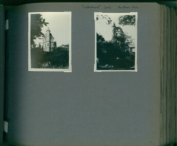
... entrance porch...isabella webb...cruden farm...Dr Solomon indicates that the mansion was demolished circa 1937. trevor hart caulfield architectural features architectural styles hawthorn road crotonhurst north caulfield gothic george henry frederick webb george webb 1860's judge webb mansion semi circular spire square turret cornish entrance porch isabella webb cruden farm stables castle-like towers j mclaughlin glen eira road walworth avenue stained glass windows organs Handwritten: "Crotonhust " (dem) Hawthorn Road [top right hand corner] / 76 [bottom right] Page 76 of Photograph Album with two portrait photographs of Crotonhurst and its grounds. ...This photograph is part of the Caulfield Historical Album 1972. This album was created in approximately 1972 as part of a project by the Caulfield Historical Society to assist in identifying buildings worthy of preservation. The album is related to a Survey the Caulfield Historical Society developed in collaboration with the National Trust of Australia (Victoria) and Caulfield City Council to identify historic buildings within the City of Caulfield that warranted the protection of a National Trust Classification. Principal photographer thought to be Trevor Hart, member of Caulfield Historical Society. Most photographs were taken between 1966-1972 with a small number of photographs being older and from unknown sources. All photographs are black and white except where stated, with 386 photographs over 198 pages. Dr Geulah Solomon's 4 volume book "Caulfield's Heritage" Vol 1 p 35 "...an elaborate double-storey spreading mansion which brought together several architectural styles to create a fairytale castle effect...". Dr Solomon indicates that the mansion was demolished circa 1937.Page 76 of Photograph Album with two portrait photographs of Crotonhurst and its grounds.Handwritten: "Crotonhust " (dem) Hawthorn Road [top right hand corner] / 76 [bottom right]trevor hart, caulfield, architectural features, architectural styles, hawthorn road, crotonhurst, north caulfield, gothic, george henry frederick webb, george webb, 1860's, judge webb, mansion, semi circular spire, square turret, cornish entrance porch, isabella webb, cruden farm, stables, castle-like towers, j mclaughlin, glen eira road, walworth avenue, stained glass windows, organs -
 Eltham District Historical Society Inc
Photograph, Edendale Farm Centenary Birthday Celebrations, Eltham, 24 Nov 1996, 24/11/96
... Two colour photographs depicting the entrance to Edendale farm with Alison Delaney and children, Erin and Gareth and of the 100 Years Birthday Cake....eltham edendale farm Two colour photographs depicting the entrance to Edendale farm with Alison Delaney and children, Erin and Gareth and of the 100 Years Birthday Cake. ...Two colour photographs depicting the entrance to Edendale farm with Alison Delaney and children, Erin and Gareth and of the 100 Years Birthday Cake.eltham, edendale farm -
 Sunshine and District Historical Society Incorporated
Archive - History of Deer Park and district 1850-1991, Several: 1976, 1979, 1980. 1991
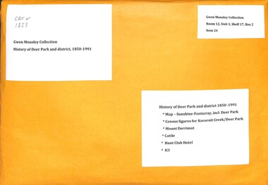
... entrance doors, inset with 12 panels to illustrate the growth of civilization. * 'Mount Derrimut - from a Colonial Past to a Country's Future' (article based on the work of Professor H.C. Forster on the history of the farm...entrance doors, inset with 12 panels to illustrate the growth of civilization. * 'Mount Derrimut - from a Colonial Past to a Country's Future' (article based on the work of Professor H.C. Forster on the history of the farm ...Part of Gwen Mousley Collectiondeer park, history -
 National Wool Museum
Craft - Toy Rabbit, 1959
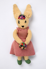
... Sometimes we would buy an ice cream for ‘Uncle’ Eric and if there weren’t any vans, prisoners or visitors in the gaol entrance courtyard I was allowed to take the ice cream to ‘Uncle’ Eric in his office after ‘Aunty’ Elsie phoned him from the residence. ‘Uncle’ Eric had a sheep farm...Sometimes we would buy an ice cream for ‘Uncle’ Eric and if there weren’t any vans, prisoners or visitors in the gaol entrance courtyard I was allowed to take the ice cream to ‘Uncle’ Eric in his office after ‘Aunty’ Elsie phoned him from the residence. ‘Uncle’ Eric had a sheep farm ...This knitted toy rabbit was given to the donor as a child, made by a prisoner at the Geelong Gaol. The donor spent Christmas holidays at the gaol, below are some of her memories of these times: Eric Stafford was the Governor of Geelong Gaol and he and Elsie Stafford lived in the Governor’s residence at the front of the gaol where I stayed during Christmas holidays from about 1959 to 1962. ‘Aunty’ Elsie had the help of prisoners with the housework. One and sometimes two prisoners did the heavy cleaning of floors, windows and furniture polishing. I remember one prisoner down on his hands and knees polishing the lino in the long hallway to a bright gleam, and when a prisoner was helping in the residence, ‘Aunty’ Elsie, the prisoner and I would always have morning tea together in the kitchen. The backyard of the Governor’s residence was divided in two. The kitchen window overlooked the front part of the yard and I was allowed to play there with the dogs as ‘Aunty’ Elsie could keep an eye on me. The back part of the yard was behind a gated wall and I was not allowed in there as prisoners worked on the back garden, the chook pen and doing general maintenance – although I sometimes sneaked in with the dogs to see the chooks and have a chat but was called back. In the back there was a large padlocked iron bound door in the large bluestone wall which ‘Uncle’ Eric could open. A couple of times he took me through this door which opened into the gaol’s large vegetable garden. I only went twice as a didn’t like going there because all the prisoners working there would stop doing what they were doing, stand and silently stare at me. Of course holidaying in Geelong there was always the great beach and carnival rides. ‘Aunty’ Elsie and I would walk to and from the beach and on the way home would stop and buy an ice cream at the nearby shop. Sometimes we would buy an ice cream for ‘Uncle’ Eric and if there weren’t any vans, prisoners or visitors in the gaol entrance courtyard I was allowed to take the ice cream to ‘Uncle’ Eric in his office after ‘Aunty’ Elsie phoned him from the residence. ‘Uncle’ Eric had a sheep farm in Meredith and sometimes he took a prisoner with him to do some work on the farm. I can remember on the way to the farm sitting in the front seat of the vehicle squeezed in between ‘Uncle’ Eric and a prisoner with the dogs and equipment in the back tray. - Donor, 2025Woollen cream knitted toy rabbit in a knitted pink dress with a knitted green petticoat, knitted green panties and a little knitted cream rabbit tail. Holding a bouquet of felt flowers and a coronet of felt jewels on the forehead. Wool embroidered eyes, nose and mouth, and whiskers of silk cord.geelong gaol, craft, prison, prisoner, governor geelong gaol, holidays, childhood, working life, eric stafford, elsie stafford, geelong, meredith, rabbit, toy, knitting, hand made -
 Sunshine and District Historical Society Incorporated
Slide - Darcy Worcester Photograph Collection, Darcy Worcester, C1955 & 1956
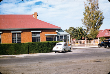
... Farm Mt. Macedon Cross Station Road Ballarat Road Millbank Road Deer Park Melbourne Mt. Macedon Mt. Derriut Derrimut 5893.01 - Darcy Worcester Photograph Collection - ICI Factory Station Road Entrance Deer Park.jpg 5893.02 - Darcy Worcester Photograph Collection - ICI Factory Deer Park Looking Towards Mess Room.jpg 5893.03 - Darcy Worcester Photograph Collection - ICI Factory Deer Park West Side.jpg 5893.04 - Darcy Worcester Photograph Collection - ICI Factory Deer Park West Side.jpg 5893.05 - Darcy Worcester Photograph Collection - ICI Factory Deer Park West Side.jpg 5893.06 - Darcy Worcester Photograph Collection - ICI Factory Deer Park East Side.jpg 5893.07 - Darcy Worcester Photograph Collection - ICI Oil Store And Cooling Tower From South East.jpg 5893.08 - Darcy Worcester Photograph Collection - ICI Calander Section.jpg 5893.09 - Darcy Worcester Photograph Collection - ICI Factory Witton Street From John McLeod Reserve.jpg 5893.10 - Darcy Worcester Photograph Collection - ICI Factory Picnic Races Maddingley Park Bacchus Marsh.jpg 5893.11 - Darcy Worcester Photograph Collection - ICI Housing Estate Deer Park.jpg 5893.12 - Darcy Worcester Photograph Collection - View Towards ICI Housing Estate Deer Park.jpg 5893.13 - Darcy Worcester Photograph Collection - Deer Park Kindergarten Millbank Drive Cnr Station Road.jpg This kindergarten was built by voluntary labour. 5893.14 - Darcy Worcester Photograph Collection - ICI Recreation Club Entrance Ballarat Road.jpg 5893.15 - Darcy Worcester Photograph Collection - ICI Recreation Club Rear Ballarat Road.jpg 5893.16 - Darcy Worcester Photograph Collection - Exhibition Gardens Melbourne.jpg 5893.17 - Darcy Worcester Photograph Collection - Exhibition Building Melbourne.jpg 5893.18 - Darcy Worcester Photograph Collection - Entrance To Government House Melbourne.jpg 5893.19 - Darcy Worcester Photograph Collection - Approach To Shrine Of Remembrance Melbourne.jpg 5893.20 - Darcy Worcester Photograph Collection - Shrine Of Remembrance Melbourne.jpg 5893.21 - Darcy Worcester Photograph Collection - View From Top Shrine Of Remembrance Melbourne Government House Side.jpg 5893.22 - Darcy Worcester Photograph Collection - View From Top Shrine Of Remembrance Melbourne Looking North West.jpg 5893.23 - Darcy Worcester Photograph Collection - View From Top Shrine Of Remembrance Melbourne Looking South.jpg 5893.24 - Darcy Worcester Photograph Collection - View From Top Shrine Of Remembrance Melbourne Looking West.jpg 5893.25 - Darcy Worcester Photograph Collection - View From Top Shrine Of Remembrance Melbourne Looking North.jpg 5893.26 - Darcy Worcester Photograph Collection - Flinders Street Station Flinders Street Cnr Swanston Street Melbourne.jpg 5893.27 - Darcy Worcester Photograph Collection - Old House In Melbourne East.jpg 5893.28 - Darcy Worcester Photograph Collection - Pt. ...ICI Deer Park was one of the most important industrial sites in Victoria, the birthplace of Australia’s commercial explosives industry and later a major chemicals, plastics, and fertiliser hub. The factory operated from 1875 until the early 2000s and shaped the entire civic, employment, and suburban landscape of Deer Park, Sunshine, St Albans, and the western suburbs. Darcy Worcester, an ICI employee was a keen photographer. He took many photographs around Melbourne when he was working for ICI during 1955 and 1956. These photographs provide a rare glimpse of the ICI Factory, Deer Park and other locations in Melbourne and Victoria during the mid 1950's5893.01 - Darcy Worcester Photograph Collection - ICI Factory Station Road Entrance Deer Park.jpg 5893.02 - Darcy Worcester Photograph Collection - ICI Factory Deer Park Looking Towards Mess Room.jpg 5893.03 - Darcy Worcester Photograph Collection - ICI Factory Deer Park West Side.jpg 5893.04 - Darcy Worcester Photograph Collection - ICI Factory Deer Park West Side.jpg 5893.05 - Darcy Worcester Photograph Collection - ICI Factory Deer Park West Side.jpg 5893.06 - Darcy Worcester Photograph Collection - ICI Factory Deer Park East Side.jpg 5893.07 - Darcy Worcester Photograph Collection - ICI Oil Store And Cooling Tower From South East.jpg 5893.08 - Darcy Worcester Photograph Collection - ICI Calander Section.jpg 5893.09 - Darcy Worcester Photograph Collection - ICI Factory Witton Street From John McLeod Reserve.jpg 5893.10 - Darcy Worcester Photograph Collection - ICI Factory Picnic Races Maddingley Park Bacchus Marsh.jpg 5893.11 - Darcy Worcester Photograph Collection - ICI Housing Estate Deer Park.jpg 5893.12 - Darcy Worcester Photograph Collection - View Towards ICI Housing Estate Deer Park.jpg 5893.13 - Darcy Worcester Photograph Collection - Deer Park Kindergarten Millbank Drive Cnr Station Road.jpg This kindergarten was built by voluntary labour. 5893.14 - Darcy Worcester Photograph Collection - ICI Recreation Club Entrance Ballarat Road.jpg 5893.15 - Darcy Worcester Photograph Collection - ICI Recreation Club Rear Ballarat Road.jpg 5893.16 - Darcy Worcester Photograph Collection - Exhibition Gardens Melbourne.jpg 5893.17 - Darcy Worcester Photograph Collection - Exhibition Building Melbourne.jpg 5893.18 - Darcy Worcester Photograph Collection - Entrance To Government House Melbourne.jpg 5893.19 - Darcy Worcester Photograph Collection - Approach To Shrine Of Remembrance Melbourne.jpg 5893.20 - Darcy Worcester Photograph Collection - Shrine Of Remembrance Melbourne.jpg 5893.21 - Darcy Worcester Photograph Collection - View From Top Shrine Of Remembrance Melbourne Government House Side.jpg 5893.22 - Darcy Worcester Photograph Collection - View From Top Shrine Of Remembrance Melbourne Looking North West.jpg 5893.23 - Darcy Worcester Photograph Collection - View From Top Shrine Of Remembrance Melbourne Looking South.jpg 5893.24 - Darcy Worcester Photograph Collection - View From Top Shrine Of Remembrance Melbourne Looking West.jpg 5893.25 - Darcy Worcester Photograph Collection - View From Top Shrine Of Remembrance Melbourne Looking North.jpg 5893.26 - Darcy Worcester Photograph Collection - Flinders Street Station Flinders Street Cnr Swanston Street Melbourne.jpg 5893.27 - Darcy Worcester Photograph Collection - Old House In Melbourne East.jpg 5893.28 - Darcy Worcester Photograph Collection - Pt. Londsale.jpg 5893.29 - Darcy Worcester Photograph Collection - Unlabelled.jpg 5893.30 - Darcy Worcester Photograph Collection - Botanical Gardens Melbourne.jpg 5893.31 - Darcy Worcester Photograph Collection - Derrimut Farm.jpg 5893.32 - Darcy Worcester Photograph Collection - Derrimut Farm.jpg 5893.33 - Darcy Worcester Photograph Collection - Derrimut Farm.jpg 5893.34 - Darcy Worcester Photograph Collection - Mt. Macedon Cross.jpg 5893.35 - Darcy Worcester Photograph Collection - Moondah Mansion Mount Eliza.jpg 5893.36 - Darcy Worcester Photograph Collection - Unlabelled.jpgici, deer park kindergarten, ici recreation club, exhibition gardens, exhibition building, government house, shrine of remembrance, flinders street station, mt. derrimut farm, mt. macedon cross, station road, ballarat road, millbank road, deer park, melbourne, mt. macedon, mt. derriut, derrimut
