Showing 211 items matching "farmland"
-
 Potter Farm Collections (RMIT Hamilton)
Video recording, Richard Keddie, Potter Farmland Plan Video
... Potter Farmland Plan Video...Educational workshops were held as part of the Potter Farmland Plan Project for participating farmers and the community....Potter Farm Collections (RMIT Hamilton) Hamilton grampians Educational workshops were held as part of the Potter Farmland Plan Project for participating farmers and the community. ...Educational workshops were held as part of the Potter Farmland Plan Project for participating farmers and the community.These videos demonstrate the community participation and teaching/learning styles that were an integral part of the project. They also demonstrate agricultural extension programs that were typical in the 1980'sBeta Film 2 reels No 31 & 32 Farmers Workshop Duration: 45 min. Shot 20/11/1989 agriculture, potter farmland plan, agricultural education, rural community, western victoria -
 Greensborough Historical Society
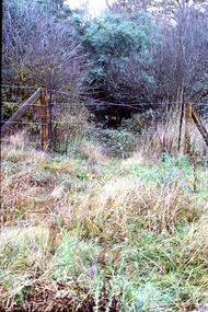
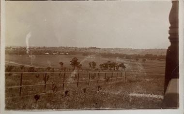
Slide - Photograph, John Ramsdale, Poorly managed farmland: Slide 121, 1990s
... Poorly managed farmland: Slide 121...Photograph shows a post and wire fence with bushland beyond, and example of poorly managed farmland, thistles in foreground....Printed maker's mark on slide "Kodak Kodachrome Slide" Colour photograph scanned from slide. Poorly managed farmland: Slide 121 Slide Photograph John Ramsdale Kodak Kodachrome ...Photograph shows a post and wire fence with bushland beyond, and example of poorly managed farmland, thistles in foreground.Part of the John Ramsdale collection of slides and audio visual material.Colour photograph scanned from slide.No caption. Printed maker's mark on slide "Kodak Kodachrome Slide"weeds, farming -
 Ballarat Heritage Services
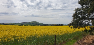
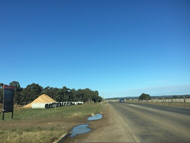
Photograph - Farmland, Clare Gervasoni, Canola near Dean, Victoria, 15/10/2024
... Farmland......Farmland...Canola near Dean, Victoria Photograph Farmland Clare Gervasoni ...Colour photographs of Canola near Dean, Victoria.dean, canola, horticulture, farmland, volcano -
 Greensborough Historical Society
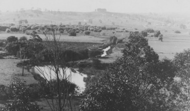
Slide - Photograph, John Ramsdale, Farmland, Lower Plenty: Slide 116, 1990s
... Farmland, Lower Plenty: Slide 116...Colour photograph scanned from slide. Farmland, Lower Plenty: Slide 116 Slide Photograph John Ramsdale ...Photograph shows a rural scene - a farmyard with stacked wood and disused farm equipment - in Lower Plenty, 1990s.Part of the John Ramsdale collection of slides and audio visual material.Colour photograph scanned from slide.No maker's marks. No caption on slide.lower plenty, farms -
 Greensborough Historical Society
Slide - Photograph, John Ramsdale, Farmland Yallambie: Slide 49, 1990s
... Farmland Yallambie: Slide 49...Colour photograph scanned from slide. Farmland Yallambie: Slide 49 Slide Photograph John Ramsdale ...Photograph shows a rural landscape with gum trees and dam; this is near Yallambie on the Plenty River.Part of the John Ramsdale collection of slides and audio visual material.Colour photograph scanned from slide.No maker's marks. No caption on slide.plenty river, yallambie -
 Narre Warren and District Family History Group
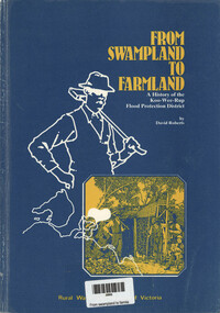
Book, David Roberts, From Swampland to Farmland - A history of the Koo Wee Rup flood protection district, 1985
... From Swampland to Farmland - A history of the Koo Wee Rup flood protection district....; 25 cm From Swampland to Farmland - A history of the Koo Wee Rup flood protection district Book David Roberts Rural Water Commission of Victoria ...A history of the Koo Wee Rup Flood Protection Districtvii, 53 p.; 25 cmnon-fictionA history of the Koo Wee Rup Flood Protection Districtkoo wee rup (vic.), koo wee rup flood protection, rural water commission of victoria -
 Brimbank City Council Art Collection
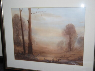
Painting (Watercolour), G. Sparks, Farmland Lodden Valley (keilor), 1981
... Farmland Lodden Valley (keilor)...Brimbank City Council Art Collection The Hunt Club Community Arts Centre 775 Ballarat Road Deer Park melbourne Local scene Watercolour, 82cmx69cm Farmland Lodden Valley (keilor) Painting (Watercolour) G. ...Local sceneWatercolour, 82cmx69cm -
 Old Colonists' Association of Ballarat Inc.
Photograph - Slide, Farmland, later to become Mount Helen Campus, 1967
... Farmland, later to become Mount Helen Campus...Old Colonists' Association of Ballarat Inc. 16-14 Lydiard (North) Street Ballarat Central goldfields Mount Helen Campus establishment farm hay agriculture Farmland, later to become Mount Helen Campus Photograph Slide ...mount helen campus, establishment, farm, hay, agriculture -
Save the Dandenongs League Inc.
Archive (item), Save the Dandenongs League Incorporated, Shire of Yarra Ranges Heritage Study - Report on Stage 1A & 2A - Volume 3: Farmland, Forest and Fern Gullies - An Environmental History of the Shire of Yarra Ranges
... Shire of Yarra Ranges Heritage Study - Report on Stage 1A & 2A - Volume 3: Farmland, Forest and Fern Gullies - An Environmental History of the Shire of Yarra Ranges...Shire of Yarra Ranges Heritage Study - Report on Stage 1A & 2A - Volume 3: Farmland, Forest and Fern Gullies - An Environmental History of the Shire of Yarra Ranges Archive Save the Dandenongs League Incorporated ... -
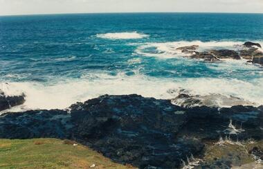
 Port Fairy Historical Society Museum and Archives
Photograph, Jock Varcoe, c.1980
... ...farmland...Coloured photograph of rolling hills and farmland...Port Fairy Historical Society Museum and Archives 30 Gipps Street Port Fairy great-ocean-road South Beach Development looking toward princes highway south beach development princes highway farmland swamp Coloured photograph of rolling hills and farmland Photograph Photograph Jock Varcoe ...South Beach Development looking toward princes highwayColoured photograph of rolling hills and farmlandsouth beach, development, princes highway, farmland, swamp -
 Ballarat Heritage Services
Photograph - Colour, Clare Gervasoni, Views from Dyson Drive, Luas, 2018
... ...farmland...A number of colour photographs showing the urban creep bording farmland at Lucas, a suburb of Ballarat....Ballarat Heritage Services PO Box 2209 Bakery Hill Post Office goldfields Dyson Drive, Lucas farmland urban sprawl A number of colour photographs showing the urban creep bording farmland at Lucas, a suburb of Ballarat. ...A number of colour photographs showing the urban creep bording farmland at Lucas, a suburb of Ballarat.dyson drive, lucas, farmland, urban sprawl -
 Port Fairy Historical Society Museum and Archives
Photograph
... ...farmland...Port Fairy looking west across the farmland to Lady Julia Percy island in background...Port Fairy Historical Society Museum and Archives 30 Gipps Street Port Fairy great-ocean-road Port Fairy looking west across the farmland to Lady Julia Percy island in background Port fairy west farmland Lady Julia percy Coloured photograph of View across grassland with Lady Julia Island in background Photograph Photograph ...Port Fairy looking west across the farmland to Lady Julia Percy island in backgroundColoured photograph of View across grassland with Lady Julia Island in backgroundport fairy, west, farmland, lady julia percy -
 Ballarat Heritage Services
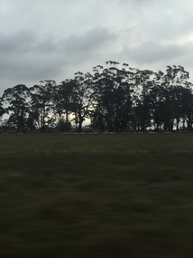
Photograph - Photograph - Colour, Clare Gervasoni, View from the Window of the Ballarat - Melbourne Train, 2016, 2016
... Farmland from the train window...Ballarat Heritage Services PO Box 2209 Bakery Hill Post Office goldfields Ballarat - Melbourne train farms landscape railway Bacchus Marsh Ballan Farmland from the train window View from the Window of the Ballarat - Melbourne Train, 2016 Photograph Photograph - Colour Clare Gervasoni ...Farmland from the train windowballarat - melbourne train, farms, landscape, railway, bacchus marsh, ballan -
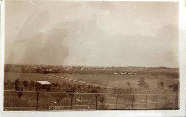
 Kew Historical Society Inc
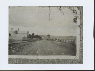
Photograph - High Street looking north to Burke Road, 1907-08
... While a number of subdivisions of what was to become Kew East occurred in the 1880s, such as the 'Mount Pleasant Estate' (1888) and 'Monterey Estate' (1888), Glynn's Lot 91 remained open farmland until the Harp Estate (1912) was sold, hence the undeveloped nature of the view in 1907-8....The photograph is taken from the Harp of Erin Hotel showing, apart from a building on the left (no longer extant), fenced open farmland stretching into the far distance....A rare image of the open farmland in the eastern part of Kew looking towards Burke Road in 1907-8. ...While a number of subdivisions of what was to become Kew East occurred in the 1880s, such as the 'Mount Pleasant Estate' (1888) and 'Monterey Estate' (1888), Glynn's Lot 91 remained open farmland until the Harp Estate (1912) was sold, hence the undeveloped nature of the view in 1907-8.A rare image of the open farmland in the eastern part of Kew looking towards Burke Road in 1907-8.Damaged, and very rare, black & white photograph of what was to become the suburb of East Kew, taken by a member of the Bennett family in 1907-8. The photograph is taken from the Harp of Erin Hotel showing, apart from a building on the left (no longer extant), fenced open farmland stretching into the far distance.HIGH ST LOOKING NOTRTH TO BURKE RD FROM HARP / EDWD GLYNN'S LOT 91 FROM 1851 / GIFT FROM BENNETT FAMILY 22 HARP RD EAST KEW 1980 / 1907-8harp of erin, high street -- east kew (vic), harp estate -
 Kiewa Valley Historical Society
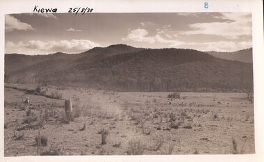
Photograph Farm Land, Kiewa, 25/8/38, circa 1938
... Black and white photograph of farmland, cattle in the distance, hills in the background...Black and white photograph of farmland, cattle in the distance, hills in the background Kiewa, 25/8/38 Photograph Farm Land possibly the State Electricity Commission of Victoria ...This photograph was taken in august, 1938 some eight years prior to the establishment of Mt. Beauty as a township. The area was still being used for grazing cattle and the land was eventually acquired from the local land owners by the State Electricity Commission. The construction of the road, from Tawonga to the High Plains, was commenced in April of 1938. This allowed men and heavy equipment to be transported to the work sites for the construction of the Kiewa Hydro Electric Scheme. Prior to this access was by bridle trail, either on horse back or by foot. By 1946 housing construction had commenced for the new town of Mt. Beauty and by 1948 street construction in the southern part of the town was completed as far as Hill Street.This is an important photograph as it shows the upper Kiewa Valley and the site for Mt. Beauty as it was before the establishment of the town. The land has been cleared of natural vegetation and used for grazing cattle.Black and white photograph of farmland, cattle in the distance, hills in the backgroundHandwritten in the upper left hand corner, in black ink, 'Kiewa 25/8/38'. The number 8 has been stamped in the upper right hand side of the photograph. On the back have been stamped the words Velox, indicating the type of photographic paper.kiewa, mt. beauty, construction, grazing, secv -
 Phillip Island and District Historical Society Inc.
Photographs, 1998
... Eleven coloured photographs of The Nobbies area and coastline and Ventnor farmland....Phillip Island and District Historical Society Inc. phillip-island-and-the-bass-coast A group of photographs donated by Henrietta Da Costa, Telopa, NSW - in order to retain local history of Phillip Island. the nobbies phillip island south coast phillip island the blowhole phillip island farmland ventnor phillip island henrietta da costa Eleven coloured photographs of The Nobbies area and coastline and Ventnor farmland. ...A group of photographs donated by Henrietta Da Costa, Telopa, NSW - in order to retain local history of Phillip Island.Eleven coloured photographs of The Nobbies area and coastline and Ventnor farmland.the nobbies phillip island, south coast phillip island, the blowhole phillip island, farmland ventnor phillip island, henrietta da costa -
Tatura Irrigation & Wartime Camps Museum
Book, Ernestine Hill, Water Into Gold, 1965
... Depicting aerial photo of farmland. White lettering...Depicting aerial photo of farmland. White lettering Water Into Gold Book Ernestine Hill Walkabout Pocketbooks Robertson and Mullens LTD ...Depicts pioneers of irrigation - Chaffey bros and story of irrigation on the MurrayBlue soft cover. Depicting aerial photo of farmland. White letteringirrigation, chaffey -
Tatura Irrigation & Wartime Camps Museum
Book, Water into Gold, 1965
... Blue soft cover, depicting aerial photo of farmland, white lettering....Tatura Irrigation & Wartime Camps Museum 49 Hogan Street Tatura the-murray Depicts pioneers of irrigation, Chaffey Bros., and story of irrigation on the Murray River water into gold irrigation hill e tatura books history local rural industry Blue soft cover, depicting aerial photo of farmland, white lettering. Water into Gold Book ...Depicts pioneers of irrigation, Chaffey Bros., and story of irrigation on the Murray RiverBlue soft cover, depicting aerial photo of farmland, white lettering.water into gold, irrigation, hill e, tatura, books, history, local, rural, industry -
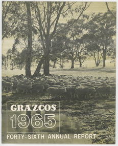 National Wool Museum
Document - Grazcos Annual Report, Grazcos Co-operative Limited, 1965
... Booklet featuring black and white image of sheep in farmland, with white text. ...Agricultural co-operative agricultural wholesaling annual reports rural life rural industry business corporate body front: GRAZCOS / 1965 / FORTY-SIXTH ANNUAL REPORT Booklet featuring black and white image of sheep in farmland, with white text. Document Grazcos Annual Report Grazcos Co-operative Limited Mockridge, Bulmer Pty. ...The co-operative was registered in 1919 as the Graziers Co-op Shearing Company Limited. It changed its name in September 1948 to Grazcos Co-operative Ltd. In 1981 the co-operative merged with Farmers & Graziers Co-op Ltd to form Farmers Grazcos Co-op Ltd. This item is part of a collection of Annual Reports from Grazcos dated from 1949 - 1980.Booklet featuring black and white image of sheep in farmland, with white text. front: GRAZCOS / 1965 / FORTY-SIXTH ANNUAL REPORTagricultural co-operative, agricultural wholesaling, annual reports, rural life, rural industry, business, corporate body -
 Kew Historical Society Inc
Photograph - Yarra Valley at Kew, 1918
... View of the farmland in the Yarra Valley at what is believed to be East Kew in 1918. .../ 1918" View of the farmland in the Yarra Valley at what is believed to be East Kew in 1918. ...During the nineteenth century, the land abutting the south side of the Yarra in Kew was devoted to dairy farming. In the twentieth century, before and after the construction of the Eastern Freeway, much of this low-lying area was used as golf courses and public parks.View of the farmland in the Yarra Valley at what is believed to be East Kew in 1918. Verso: "Willsmere / East Kew? / 1918"yarra river, yarra valley -
 Bendigo Historical Society Inc.
Photograph - NORM GILLIES COLLECTION: PHOTOGRAPH OPEN FARM LAND
... coloured photograph of open farmland Rear note: Donald Gillies and his brothers, sister grew up in this farmland. ...Norm Gillies Collection Farming coloured photograph of open farmland Rear note: Donald Gillies and his brothers, sister grew up in this farmland. ...coloured photograph of open farmland Rear note: Donald Gillies and his brothers, sister grew up in this farmland. Donald was the father of three brothers who started Gillies Pies (in Bendigo). Alan, Norman, Leslie.norm gillies collection, farming -
 Kew Historical Society Inc
Photograph - Yarra Valley at Kew, 1912
... Real-photo postcard of the farmland in the Yarra Valley in what is believed to be North Kew in 1912. ...Verso: "Willsmere / East Kew / 1912" Real-photo postcard of the farmland in the Yarra Valley in what is believed to be North Kew in 1912. ...During the nineteenth century, the land abutting the south side of the Yarra in Kew was devoted to dairy farming. In the twentieth century, before and after the construction of the Eastern Freeway, much of this low-lying area was used as golf courses and public parks.Real-photo postcard of the farmland in the Yarra Valley in what is believed to be North Kew in 1912. Verso: "Willsmere / East Kew / 1912"yarra river, yarra valley, farming -- kew (vic.) -
 Lakes Entrance Historical Society
Postcard - farmland Bruthen-Tambo Upper c1900
... Sepia toned postcard showing farmland in Bruthen Tambo Upper area Bruthen Victoria...Settlement Agriculture CGR Sepia toned postcard showing farmland in Bruthen Tambo Upper area Bruthen Victoria Postcard farmland Bruthen-Tambo Upper c1900 ...Sepia toned postcard showing farmland in Bruthen Tambo Upper area Bruthen VictoriaCGRsettlement, agriculture -
 Ballarat Heritage Services
Photograph, Clare Gervasoni, View From St Paul's Church of England, Henty, 2015, 22/12/2015
... Colour photograph of farmland at Henty, Victoria. It was taken from St Paul's Church of England, Henty. ...Ballarat Heritage Services PO Box 2209 Bakery Hill Post Office goldfields This church is associated with the Henty family of Merino Downs. henty st paul's church of england, henty st paul's anglican church, henty Colour photograph of farmland at Henty, Victoria. It was taken from St Paul's Church of England, Henty. ...This church is associated with the Henty family of Merino Downs.Colour photograph of farmland at Henty, Victoria. It was taken from St Paul's Church of England, Henty. henty, st paul's church of england, henty, st paul's anglican church, henty -
 Lakes Entrance Historical Society
Photograph, Tambo Shire, 1994
... Colour photograph taken at The Basin, showing hilly farmland, dense forest on ranges in distance. ...Lakes Entrance Historical Society 4 Marine Parade Lakes Entrance gippsland Also second similar copy Topography Vegetation Colour photograph taken at The Basin, showing hilly farmland, dense forest on ranges in distance. ...Also second similar copyColour photograph taken at The Basin, showing hilly farmland, dense forest on ranges in distance. Buchan Victoriatopography, vegetation -
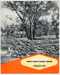 National Wool Museum
Document - Grazcos Annual Report, Grazcos Co-operative Limited, 1957
... Booklet featuring a black and white image of sheep in farmland, with printed black, white, yellow and red text. ...Agricultural co-operative agricultural wholesaling annual reports rural life rural industry business corporate body front: 1957 / THIRTY-EIGHT ANNUAL REPORT / GRAZCOS / CO-OPERATIVE LIMITED Booklet featuring a black and white image of sheep in farmland, with printed black, white, yellow and red text. ...The co-operative was registered in 1919 as the Graziers Co-op Shearing Company Limited. It changed its name in September 1948 to Grazcos Co-operative Ltd. In 1981 the co-operative merged with Farmers & Graziers Co-op Ltd to form Farmers Grazcos Co-op Ltd. This item is part of a collection of Annual Reports from Grazcos dated from 1949 - 1980.Booklet featuring a black and white image of sheep in farmland, with printed black, white, yellow and red text. front: 1957 / THIRTY-EIGHT ANNUAL REPORT / GRAZCOS / CO-OPERATIVE LIMITEDagricultural co-operative, agricultural wholesaling, annual reports, rural life, rural industry, business, corporate body -
Moorabbin Air Museum
Book - Bellanca C.F, Jay P. Spenser et al, Bellanca C.F. The Emergence of the Cabin Monoplane in the United States
... Front, Illustration of a Bellanca C.F fling over farmland. Back book summery and Photograph of a Bellanca C.F....Front, Illustration of a Bellanca C.F fling over farmland. Back book summery and Photograph of a Bellanca C.F. ...A history of the development of the Bellanca C.F. Contains historical information on the designer, his story, and the development of the Bellanca C.F.Front, Illustration of a Bellanca C.F fling over farmland. Back book summery and Photograph of a Bellanca C.F.A history of the development of the Bellanca C.F. Contains historical information on the designer, his story, and the development of the Bellanca C.F.ballanca, monoplane -
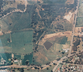 Federation University Historical Collection
Photograph, Aerial photograph of Mount Helen Campus prior to construction, c1967, c1967
... Laminated large format coloured photographic print of the farmland at Mount Helen that bacame the Mount Helen Campus. ...mount helen campus aerial colour photograph aerial photograph Laminated large format coloured photographic print of the farmland at Mount Helen that bacame the Mount Helen Campus. ...Laminated large format coloured photographic print of the farmland at Mount Helen that bacame the Mount Helen Campus. mount helen campus aerial, colour photograph, aerial photograph -
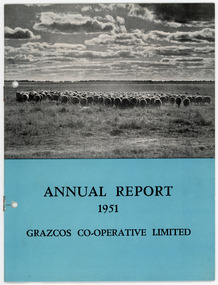 National Wool Museum
Document - Grazcos Annual Report, Grazcos Co-operative Limited, 1951
... Booklet featuring a black and white image of sheep and farmland, with printed black text on blue background below image....Agricultural co-operative agricultural wholesaling annual reports rural life rural industry business corporate body front: ANNUAL REPORT / 1951 / GRAZCOS CO-OPERATIVE LIMITED Booklet featuring a black and white image of sheep and farmland, with printed black text on blue background below image. ...The co-operative was registered in 1919 as the Graziers Co-op Shearing Company Limited. It changed its name in September 1948 to Grazcos Co-operative Ltd. In 1981 the co-operative merged with Farmers & Graziers Co-op Ltd to form Farmers Grazcos Co-op Ltd. This item is part of a collection of Annual Reports from Grazcos dated from 1949 - 1980.Booklet featuring a black and white image of sheep and farmland, with printed black text on blue background below image.front: ANNUAL REPORT / 1951 / GRAZCOS CO-OPERATIVE LIMITEDagricultural co-operative, agricultural wholesaling, annual reports, rural life, rural industry, business, corporate body -
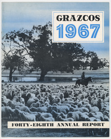 National Wool Museum
Document - Grazcos Annual Report, Grazcos Co-operative Limited, 1967
... Image depicts sheep on farmland with man on horseback in the background. ...Image depicts sheep on farmland with man on horseback in the background. ...The co-operative was registered in 1919 as the Graziers Co-op Shearing Company Limited. It changed its name in September 1948 to Grazcos Co-operative Ltd. In 1981 the co-operative merged with Farmers & Graziers Co-op Ltd to form Farmers Grazcos Co-op Ltd. This item is part of a collection of Annual Reports from Grazcos dated from 1949 - 1980.Booklet featuring blue, white and black text and graphics. Image depicts sheep on farmland with man on horseback in the background. front: GRAZCOS / 1967 / FORTY-EIGHTH ANNUAL REPORTagricultural co-operative, agricultural wholesaling, annual reports, rural life, rural industry, business, corporate body