Showing 104 items matching "fence at cemetery"
-
 Bendigo Historical Society Inc.
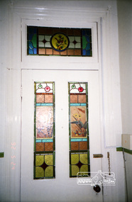
Photograph - FRIENDS OF WHITE HILLS CEMETERY COLLECTION: PHOTOGRAPH
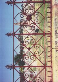
... ...cast iron fence at cemetery...Copy of a coloured photograph of a section of cast iron fence at Bendigo Cemetery....History House 11 Mackenzie Street Bendigo goldfields PHOTOGRAPH Landscape cast iron fence at cemetery Photograph. Copy of a coloured photograph of a section of cast iron fence at Bendigo Cemetery. ...Photograph. Copy of a coloured photograph of a section of cast iron fence at Bendigo Cemetery.photograph, landscape, cast iron fence at cemetery -
 Bendigo Historical Society Inc.
Photograph - FRIENDS OF WHITE HILLS CEMETERY COLLECTION: COLOURED PHOTOGRAPH
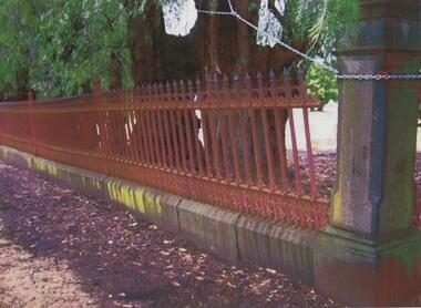
... ...fence at cemetery...Coloured photograph of a section of the cast iron fence at the White Hills Cemetery....History House 11 Mackenzie Street Bendigo goldfields PHOTOGRAPH Landscape fence at cemetery Photograph. Coloured photograph of a section of the cast iron fence at the White Hills Cemetery. ...Photograph. Coloured photograph of a section of the cast iron fence at the White Hills Cemetery.photograph, landscape, fence at cemetery -
 Bendigo Historical Society Inc.
Photograph - FRIENDS OF WHITE HILLS CEMETERY COLLECTION: COPY OF PHOTOGRAPH
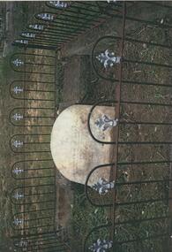
... ...cast iron fence at cemetery...History House 11 Mackenzie Street Bendigo goldfields PHOTOGRAPH Landscape cast iron fence at cemetery Photograph. Copy of a coloured photograph of a headstone surrounded by a cast iron fence. ...Photograph. Copy of a coloured photograph of a headstone surrounded by a cast iron fence.photograph, landscape, cast iron fence at cemetery -
 Bendigo Historical Society Inc.
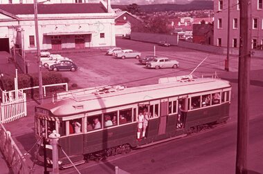
Photograph - BASIL MILLER COLLECTION: TRAM ON CARPENTER ST
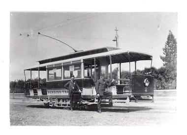
... Black and white photo of Bendigo Tramways tram with Driver and Conductor on Carpenter St, note Cemetery fence in background....History House 11 Mackenzie Street Bendigo goldfields PERSON Individual basil miller Black and white photo of Bendigo Tramways tram with Driver and Conductor on Carpenter St, note Cemetery fence in background. Photograph BASIL MILLER COLLECTION: TRAM ON CARPENTER ST ...Black and white photo of Bendigo Tramways tram with Driver and Conductor on Carpenter St, note Cemetery fence in background.person, individual, basil miller -
 Bendigo Historical Society Inc.
Photograph - ESTELLE HEWSTON COLLECTION: BENDIGO CEMETERY, April 1991
... Bendigo Cemetery. Original features. Gates. Fence. Rotunda....6 colour photographs: Bendigo Cemetery, April 1991 8A & 8B Cemetery Chapel. 8C Horse hitching posts, Carpenter Street. 8D Rotunda. 8E Cemetery Gates. 8F Decorative Cemetery fence, Carpenter Street....Bendigo Cemetery. Original features. Gates. Fence. Rotunda. Estelle Hewston 6 colour photographs: Bendigo Cemetery, April 1991 8A & 8B Cemetery Chapel. 8C Horse hitching posts, Carpenter Street. 8D Rotunda. 8E Cemetery Gates. 8F Decorative Cemetery fence, Carpenter Street. ...6 colour photographs: Bendigo Cemetery, April 1991 8A & 8B Cemetery Chapel. 8C Horse hitching posts, Carpenter Street. 8D Rotunda. 8E Cemetery Gates. 8F Decorative Cemetery fence, Carpenter Street.Estelle Hewstonbendigo cemetery. original features. gates. fence. rotunda. -
 Ballarat Tramway Museum
Slide - 35mm slide/s - set of 9, Noel Simons, Sept. 1971
... Photo taken from under the verandah of a shop on the south side of the street that were many years later to become the Tramcar Restaurant. Note metal fence to cemetery. 1174.6 - Nos. 21 (Sebastopol) crossing 14 (Lydiard St. ...Photo taken from under the verandah of a shop on the south side of the street that were many years later to become the Tramcar Restaurant. Note metal fence to cemetery. 1174.6 - Nos. 21 (Sebastopol) crossing 14 (Lydiard St. ...Set of 9 Kodak Ready-mount with slides made from the Association of Railway Enthusiast Provincial Tramways film strip. Reference Item 2560 details the ARE Film Strip, and provide references to other slides. See also Reg. item 1164. 1174.9 on plain white mount. 1174.1 - Tram 40 North bound for Lydiard St. North at the Railway Gates, with the gates closed. Tram carrying a heavy load of passengers. Railway station building and car park in background. Taken from the signal box. 1174.2 - Tram 12 bound for Gardens, photographed across the median strip plantation near Dawson St. Image i2a - adjusted 9/2021 to remove colour cast. 1174.3 - Tram 43 in bound along Wendouree Parade near Barrett Ave, passing a former tram stop and with "Warning Oncoming Trams" sign mounted on an adjacent pole. See also Reg. item 1172.1 for a photo taken in May 1971. This photo taken after the closure of the Victoria St. line, as the tram stop has been painted out. 1174.4 - Looking along the track to Sebastopol terminus on the west side of Albert St. - telephoto shot showing bogie tram in the far distance. Shows the nature of the track, poles, tram stop frequency and in the fare distance the terminus. Also show the trees that used to be along this section of the track. 1174.5 - No. 42 showing "Special" in Macarthur St. approaching Drummond St. north. Photo taken from under the verandah of a shop on the south side of the street that were many years later to become the Tramcar Restaurant. Note metal fence to cemetery. 1174.6 - Nos. 21 (Sebastopol) crossing 14 (Lydiard St. Nth) at the loop between Sayle and Grey St. Photo taken looking south. 1174.7 - No. 12 bound for Mt Pleasant, in Bridge St. about to stop at the junction for the two routes. Telephoto photo looking west along Bridge St. with many cars in the photo. Very few people on the street itself. 1174.8 - No. 30 and 17 at the City Terminus, on the north side of Sturt St. Taken from the Post Office corner with the Town Hall in the background. 1174.9 - No. 39 inbound along Sturt St. West. with many cars on the road. Bus stop on a pole on the other side of the road.1174.1 - "No. 40 on Lydiard St. North service waits at the level crossing at Ballarat Railway Station." 1174.2 - "No. 12 bound for 'Gardens' seen across the centre plantation in Sturt St." 1174.3 - "Barrett Ave." 1174.4 - "The Sebastopol route near the terminus" 1174.6 - "Nos. 21 and 14 crossing at Sayle St. Loop on Sebastopol route" 1174.7 - "No. 12 at Eastern end of Bridge St." 1174.8 - "Nos. 30 and 17 in Sturt St. at Cnr of Lydiard St." 1174.9 - "No. 39 City bound from 'Gardens" in Sturt St. West" All have date stamp of "Sep 1971" in black ink. Writing in blue ink.tramways, trams, lydiard st. nth, railway crossing, sturt st, wendouree parade, sebastopol, macarthur st., bridge st., sturt st. west, tram 12, tram 14, tram 17, tram 21, tram 30, tram 39, tram 40, tram 42, tram 43 -
 Kiewa Valley Historical Society
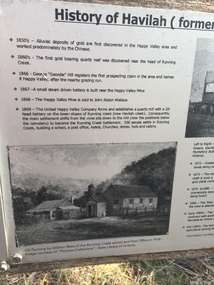
Papers - Havilah Cemetery, Havilah Cemetery Formerly Running Creek Cemetery
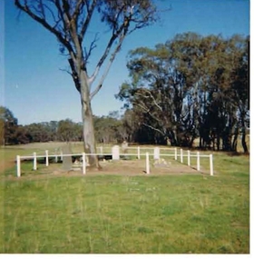
... The Cemetery was decommissioned in the early 1950s and the last trustee for the cemetery died in 1986. There is a wooden fence around the boundary (May 2024). ...The Cemetery was decommissioned in the early 1950s and the last trustee for the cemetery died in 1986. There is a wooden fence around the boundary (May 2024). ...In 1889, 24 residents of the Running Creek and surrounding district submitted a petition to the Minister of Lands, Melbourne requesting land for a cemetery. Their request was granted. The Cemetery was decommissioned in the early 1950s and the last trustee for the cemetery died in 1986. There is a wooden fence around the boundary (May 2024). One paper lists 29 names in the Burial Register 1861-1948. The last two sheets record the history as a timeline from the 1850s to the 1900s. Havilah was a gold mining settlement from the 1850s located 20km west of the Kiewa Valley and in the Ovens catchment near Myrtleford.Five black and white A4 pages stapled together. Copies of the sign erected at the gate of 'Havilah cemetery formerly Running Creek Cemetery'. Also the 'History of Havilah formerly Running Creek'havilah, running creek, cemetery -
 Eltham District Historical Society Inc
Photograph - Digital Photograph, Alan King, Garden Hill, Eltham-Yarra Glen Road, Kangaroo Ground, 3 February 2008
... Cemetery. Scottish farmer Harkness, who was born in 1817, acquired this property in 18492 and he and his family occupied it until the early 1920s. Harkness cleared its 152 acres (61.4 ha), fenced...Cemetery. Scottish farmer Harkness, who was born in 1817, acquired this property in 18492 and he and his family occupied it until the early 1920s. Harkness cleared its 152 acres (61.4 ha), fenced ...The original house was built around 1850 was one of Kangaroo Ground's earliest homes, part of which remains today. Built by Scottish farmer Andrew Harkness who acquired the property in 1849 at the top of the hill with magnificent panoramic views as far as Kinglake, the same year he married Sarah Oswin. The property was known as Garden Hill from at least 1865. Andrew and Sarah had four sons and five daughters. Harkness was a founder of the Kangaroo Ground School and one of the first to suggest establishing the Eltham District Road Board (1858-71) of which he was a member, the pre-cursor to the Shire of Eltham (1871-1994). He was also a Trustee of the Kangaroo Ground Cemetery. His daughter Fanny married farmer Alexander White who purchased the property in 1893. Alexander White died in 1906 and ownership transferred to Fanny White. Son, Robert White was a Councillor of the Shire of Eltham at the time the Shire acquired two acres of land on the adjacent property from the Mess brothers for the creation of the Shire of Eltham Memorial Park (1921) in which the Shire of Eltham War Memoirial tower was erected (1926). Fanny White donated a small section of land from the Garden Hill property to facilitate entry access to the park. The White family sold the property to Sir Herbert Gepp in 1925. Covered under Heritage Overlay, Nillumbik Planning Scheme. Published: Nillumbik Now and Then / Marguerite Marshall 2008; photographs Alan King with Marguerite Marshall.; p29 Garden Hill, on Yarra Glen Road, Kangaroo Ground, near the War Memorial is well named. The old house and gardens overlook a magnificent panorama extending to Kinglake. The original house, built around 1850, was one of Kangaroo Ground’s earliest, and part of it remains in today’s timber house. The house was built by the early and prominent settler Andrew Harkness. Later it was occupied for a long time by Sir Herbert Gepp, renowned Australia wide.1 Harkness and Gepp are buried in the Kangaroo Ground Cemetery. Scottish farmer Harkness, who was born in 1817, acquired this property in 18492 and he and his family occupied it until the early 1920s. Harkness cleared its 152 acres (61.4 ha), fenced it and grazed sheep and cattle. Harkness proved a valuable community member. When only ten families lived in the district, he and other settlers set up a school in 1852, with Andrew Ross as the first teacher. Harkness was also one of the first to suggest establishing the Eltham District Road Board, of which he was a member for around 15 years. He was also a trustee of the Kangaroo Ground Cemetery. Harkness married in 1854 and had four sons and five daughters. The first part of the timber house he built included a kitchen-living room and a parlor. The living room’s large fireplace was bricked-in and modernised in 1940. Beside it is the old baker’s oven with its original iron door replaced by a wooden one. It is thought two wattle-and-daub huts, used for a bedroom and bathroom, were built to the west. Harkness’ son-in-law, farmer Alexander White, who had seven sons, bought the property in 1893. Harkness’ grand-daughter Flora married Ewen Cameron who became Minister for Health and was later knighted; he was not related to Ewen Hugh Cameron, a Member of the Legislative Assembly. In 1923 the White family sold the property, called Kilby Park, to Sir Herbert Gepp, who renamed it Garden Hill. Gepp used the property, which was still on the original New South Wales title, as a hobby farm. Robert White stayed on to manage the farm for a while, living in a house on the property. Gepp was born in 1877 and at 16 years began working as a junior chemist with the Australian Explosives and Chemical Company at Deer Park near Melbourne. Gepp was a pioneer in applying enlightened labour policies in industry. He initiated the Broken Hill Progress Association, to improve living conditions. It laid the ground work for the welfare schemes pursued by companies after World War One. During the mid 20th century Gepp was the most prominent liberal thinker associated with conservative politics. As a friend of Prime Minister John Curtin, he contributed to post-war reconstruction. Gepp returned to private industry and retired in 1950. Gepp made significant contributions to the solution of the great metallurgical problems of the mining industry. He was an advocate of the role of science in industry, government and the economy and helped to establish several organizations including the CSIR and the Institute of Public Affairs.3 After Sir Herbert died in 1954 his son Orwell continued to farm the property part-time. When Lady Gepp died in 1963, the land was divided among the five children, although Orwell continued to farm it as a hobby. In 1966, a daughter, Mardi Gething, now married, settled in the house. Another daughter, Kathleen, built her house close by on the property. After the Board of Works designated the property as part of a reserve for a possible reservoir, the family sold all, except the minimum 20 acres allowed, to the Board in the 1970s. Orwell then leased what was the family property from the Board to continue grazing. The two sisters and brother continued to live on the property.This collection of almost 130 photos about places and people within the Shire of Nillumbik, an urban and rural municipality in Melbourne's north, contributes to an understanding of the history of the Shire. Published in 2008 immediately prior to the Black Saturday bushfires of February 7, 2009, it documents sites that were impacted, and in some cases destroyed by the fires. It includes photographs taken especially for the publication, creating a unique time capsule representing the Shire in the early 21st century. It remains the most recent comprehenesive publication devoted to the Shire's history connecting local residents to the past. nillumbik now and then (marshall-king) collection, kangaroo ground -
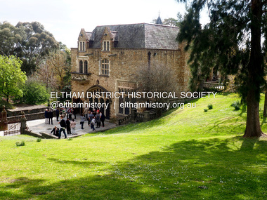 Eltham District Historical Society Inc
Photograph - Digital Photograph, Jim Connor, Eltham Cemetery Trust's launch at Montsalvat of Our Eltham - Artistic Recollections, 21 September 2017
... Cemetery more than 150 years ago. Depicting scenes of life in and around Eltham, the collection offers deeper connections to the Eltham area through a series of visual narratives of Eltham’s past, environment and community. The project involves the artistic interpretation by Nerina Lascelles of historic and current images symbolically intermixed with locally indigenous flowers and plants. These are displayed on thirty-one ceramic panels by Linda Detoma, mounted within an iron fence...Cemetery more than 150 years ago. Depicting scenes of life in and around Eltham, the collection offers deeper connections to the Eltham area through a series of visual narratives of Eltham’s past, environment and community. The project involves the artistic interpretation by Nerina Lascelles of historic and current images symbolically intermixed with locally indigenous flowers and plants. These are displayed on thirty-one ceramic panels by Linda Detoma, mounted within an iron fence ...Our Eltham - Artistic Recollections by Jim Connor, EDHS newsletter No. 236 October 2017 The Eltham Cemetery Trust, established in 1858, selected the existing burial site at Mount Pleasant Road on high ground overlooking the village of Eltham. The first recorded burial took place in 1861 in the Church of England section. Headstones depict the names of many early and well known local families. In recent years the Trust has encouraged the use of creative artistic elements within the natural bushland environment in their landscaped grounds adjoining Montsalvat. Their ongoing vision has been to offer the local communty a fresh and unique relationship to the Cemetery. On Thursday 21st September 2017 their latest commissioned art project titled ‘Our Eltham - Artistic Recollections’ was unveiled. It is a collection of panels collaboratively created by artist Nerina Lascelles and ceramicist Linda Detoma. The project was designed and constructed by Leigh Wykes using Australian stone with ironwork by Neil Carter. All contributors to this installation, located adjacent to the car park near Metery Road, are residents of the Eltham area. Our Eltham - Artistic Recollections is described as a celebration of life in the Shire since the opening of the Eltham Cemetery more than 150 years ago. Depicting scenes of life in and around Eltham, the collection offers deeper connections to the Eltham area through a series of visual narratives of Eltham’s past, environment and community. The project involves the artistic interpretation by Nerina Lascelles of historic and current images symbolically intermixed with locally indigenous flowers and plants. These are displayed on thirty-one ceramic panels by Linda Detoma, mounted within an iron fence by Neil Carter, upon an attractive rock wall constructed by Leigh Wykes. The Eltham District Historical Society is pleased to have contributed to this project. Russell Yeoman and Jim Connor from our Society have collaborated with Liz Pidgeon, Local and Family History Librarian at Yarra Plenty Regional Library on a selection of photographs, many from the Shire of Eltham Pioneers Collection we hold in partnership, located at Eltham Library. We also provided information on the images chosen. The Eltham Cemetery Trust has produced a booklet about this artwork, which can be viewed on the Cemetery website at: http://www.elthamcemetery.com/oureltham/#1 Our Eltham - Artistic Recollections is a significant monumental installation, which will encourage visitors to come to view this outstanding combination of local creative skills, set within the attractive grounds of the Eltham Cemetery. jim connor collection, eltham cemetery trust, montsalvat, our eltham artistic recollections, 2017-09-21 -
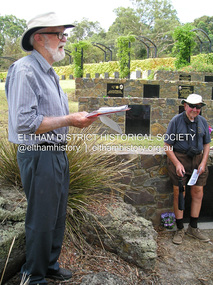 Eltham District Historical Society Inc
Photograph, Fay Bridge, EDHS Heritage Excursion Eltham Cemetery, 5 March 2016
... cemetery. We were also able to view the recently installed sculpture titled ‘A Currawong Takes Flight’ by Michael Wilson located at the highest point of the fence-lined border between Montsalvat and the cemetery. ...cemetery. We were also able to view the recently installed sculpture titled ‘A Currawong Takes Flight’ by Michael Wilson located at the highest point of the fence-lined border between Montsalvat and the cemetery. ...The Eltham Cemetery Trust, established in 1858, selected the existing burial site at Mount Pleasant Road on high ground overlooking the village of Eltham. The first recorded burial took place in 1861 in the Church of England section. Headstones depict the names of many early and well known local families. On Saturday 5th March 2016 Harry Gilham again lead members and visitors on a heritage excursion through parts of the cemetery, while providing background information on selected individuals buried there. Harry’s cemetery walks have always been popular, and members and visitors were encouraged to come along and experience the tranquil surroundings of this picturesque cemetery. We were also able to view the recently installed sculpture titled ‘A Currawong Takes Flight’ by Michael Wilson located at the highest point of the fence-lined border between Montsalvat and the cemetery. It is close to the last bronze sculpture by Matcham Skipper, titled ‘Young Man Awakening’, commissioned by the Eltham Cemetery Trust to celebrate the 150th Anniversary of the cemetery in 2008. As an addition, we also met the artists and stonemason and given a brief background into the Trust’s newest art project installation titled “Our Eltham – Artistic Recollections” which will feature ceramic panels containing artwork with a local history theme. The work is the joint creation of artist Nerina Lascelles and ceramicist Linda Detoma, supported with stonework by Leigh Wykes and steelwork by Neil Carter, all skilled local Nillumbik artisans.fay bridge collection, 2016-03-05, eltham cemetery, geoff watt, jim connor, leigh wykes, linda detoma, nerina lascelles, young man awakening, harry gilham -
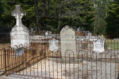 Eltham District Historical Society Inc
Photograph - Digital Photograph, Alan King, Graves of Thomas Sweeney and family, Eltham Cemetery, Victoria, 27 January 2008
... In 1861 the cemetery included Church of England, Presbyterian, Roman Catholic and Wesleyans (later Methodist) sites. Graves also indicated social class. Some had grand tombstones, perhaps fenced...In 1861 the cemetery included Church of England, Presbyterian, Roman Catholic and Wesleyans (later Methodist) sites. Graves also indicated social class. Some had grand tombstones, perhaps fenced ...The grave of Thomas Sweeney, former convict turned respectable citizen. The Murray and Sweeney families were both early settlers of the Eltham district and connected by marriage. Their family plots are located side by side in the Catholic section of the Eltham Cemetery. Irish-born Thomas Sweeney is regarded as the first settler in Eltham. He was transported to Sydney in 1823 after being convicted of arson. He was granted his freedom in 1838 and married Margaret Meehan in the same year. They moved to Melbourne and in 1842 Thomas purchased 110 acres beside the Yarra River in the vicinity of present-day Sweeneys Lane. He called the property ‘Culla Hill’ and built a small slab hut (reputedly with Wurundjeri help; Margaret is said to have run an informal hospital for them in return). This was followed in 1846 by more substantial buildings consisting of a three-roomed Irish-style ‘longhouse’ and a barn made of stone and handmade bricks, with doors large enough to accommodate a fully loaded wagon. When the gold rush came, Thomas prospered by selling meat and potatoes to the prospectors, enabling him to purchase a further 308 acres in 1856. He promoted the construction of a bridge over the Plenty River and the establishment of a school at Eltham. Roman Catholic Church services were held at Culla Hill in the early years. When he died in 1867, he was regarded as a respected member of the community. Thomas and Margaret are buried in Eltham Cemetery with many of their descendants. Their first son John continued to farm Culla Hill until his death in 1909. Culla Hill passed out of the Sweeneys' possession in 1939. The house and barn remain today, though lesser outbuildings have gone. The facade of the house is much the same as it was in the 1840s. Sacred To the memory of Thomas Sweeney Who died Sep 6th 1867 Aged 65 years May his soul res in peace Also his wife Margaret Died Oct 3rd 1884 aged 73 years And their daughters Annie Died Aug 22nd 1860 aged 21 years Johanna Died Aug 19th 1872 aged 22 years Margaret Died 7th Sep 1913 aged 72 years R.I.P. Also In Memory Of John Sweeney Died 24th May 1909 Aged 65 years Also of his wife Ellen Died 8th March 1910 Aged 64 years R.I.P Also In Memory Of Caroline Infant daughter of John & Ellen Sweeney Published: Nillumbik Now and Then / Marguerite Marshall 2008; photographs Alan King with Marguerite Marshall.; p55 From the piety and poverty of 19th century Eltham, 20th century artists and environmentalists, to today’s comfortable middle class, Eltham Cemetery records it all — and more. A visit to Eltham Cemetery reveals an important social record since its beginnings in 1858. The cemetery was situated on about six acres (2.4ha) (now around 4.8ha) at the corner of Mount Pleasant and Metery Roads.1* It is thought that Metery Road was originally called Cemetery Road, but in the early 1940s, a resident, possibly a councillor, objected to the name resulting in the change.2 Much can be gleaned about the developing Eltham community from burial styles and the names of former local residents. Originally the cemetery was divided into Christian denominations, like others of that time, following the United Kingdom burial system. In 1861 the cemetery included Church of England, Presbyterian, Roman Catholic and Wesleyans (later Methodist) sites. Graves also indicated social class. Some had grand tombstones, perhaps fenced with ornamental cast iron railing, but most in the 1860s and 1870s were constructed of modest stone slabs.3 This indicated the poverty of the district, which was largely inhabited by farmers on small landholdings. A poignant reminder of the high rates of infant mortality of those times, are the many infants and young children recorded on the headstones. Major changes occurred in the cemetery in the late 20th century as Christian adherence weakened and society became more egalitarian and informal. In the early 1970s a non-denominational lawn section for burials was established. Since then all new areas have been non-denominational to accommodate the more diverse local community. Now, instead of large ornamental headstones, some mourners have chosen boulders, reflecting the natural Eltham style, while others choose graves in the lawn areas or niches in walls. In the late 1970s, the University Donor Section was established north-west of Candlebark Lawn for those who donated their bodies for The University of Melbourne medical research. In the early 1980s the natural Australian garden style, popular in Eltham, was mirrored in a new section called Ashes Walk. Local landscape architect Gordon Ford, who had popularised this style, designed the Walk using boulders shaded by native plants beside curved pathways. Landscape architect Robert Boyle later redesigned Ashes Walk and developed other parts of the cemetery in keeping with this style.4 Appropriately Ford, who died in 1999, was interred in the Native Garden Section in a cluster of sites shaded by a large eucalyptus tree.5 By 2007, about 6400 interments were recorded in the Eltham Cemetery. Close inspection reveals notable names in the district’s history. The grave of Thomas Sweeney, a former convict who became a respected citizen, can be found in the Roman Catholic section near the path. Eltham Primary School’s first headmaster, David Clark, is buried in a modest grave in the Church of England section to the east of the path from the main entrance. Sir William Irvine, Victorian Premier from 1900 to 1902, whose grave is in the north-east Presbyterian section was at various times Victoria’s Chief Justice, Deputy Governor and Treasurer.6 Further south is the grave of social reformer Bertram Wainer, born in Scotland in 1928 and died in 1987. He campaigned to legalise abortion and exposed police corruption in allowing illegal ‘backyard’ abortions. Other prominent local residents interred in the cemetery include: Justus Jörgensen, who founded Montsalvat; Alistair Knox, the mud-brick housing pioneer and Eltham Shire Councillor from 1971 to 1975 and President in 1975; Clem and Nina Christensen, who had a major influence on the literary development of post World War Two Australia. Others were: composer Dorian Le Gallienne; artist Peter Glass; Stephen Dattner, a prominent Melbourne furrier; ALP parliamentarian for Greensborough, Pauline Toner and political scientist and commentator, Professor William Macmahon Ball.This collection of almost 130 photos about places and people within the Shire of Nillumbik, an urban and rural municipality in Melbourne's north, contributes to an understanding of the history of the Shire. Published in 2008 immediately prior to the Black Saturday bushfires of February 7, 2009, it documents sites that were impacted, and in some cases destroyed by the fires. It includes photographs taken especially for the publication, creating a unique time capsule representing the Shire in the early 21st century. It remains the most recent comprehenesive publication devoted to the Shire's history connecting local residents to the past. nillumbik now and then (marshall-king) collection, annie sweeney, caroline sweeney, ellen sweeney, eltham cemetery, graves, gravestones, johanna sweeney, john murray, john sweeney, margaret sweeney, mary ellen drain, mary murray, thomas murray, thomas sweeney -
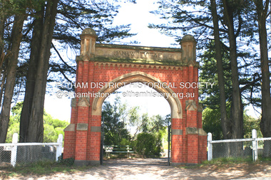 Eltham District Historical Society Inc
Photograph - Digital Photograph, Alan King, Memorial Arch Gateway, Nillumbik Cemetery, Diamond Creek, 23 January 2008
... cemetery gateway arch. The burial ground has associated structures, such as the hexagonal timber sexton's office, post and wire fence and picket hand gate along Main Street, all probably built in the early twentieth century. ...cemetery gateway arch. The burial ground has associated structures, such as the hexagonal timber sexton's office, post and wire fence and picket hand gate along Main Street, all probably built in the early twentieth century. ...The Nillumbik Cemetery is of historical, architectural, aesthetic and social significance at a Regional level (North-east Melbourne). The memorial arch is of State significance. Nillumbik Cemetery, which was established in 1867, is of historical and social significance for its association with the early history of Diamond Creek and as a record of the pioneering families of the district. Significant graves include those of the famous writer Alan Marshall, author of 'I Can Jump Puddles', footballer Gordon Coventry, and William Ellis, notable early settler and benefactor. The 1897 Tudor/Gothic revival memorial arch, bequeathed by William Ellis, is a rare design in ornamental gateways and is relatively large for the size of the cemetery. It is unique in Victoria as a cemetery gateway arch. The burial ground has associated structures, such as the hexagonal timber sexton's office, post and wire fence and picket hand gate along Main Street, all probably built in the early twentieth century. Covered under Heritage Overlay, Nillumbik Planning Scheme. National Trust of Australia (Victoria) - Regional significance Published: Nillumbik Now and Then / Marguerite Marshall 2008; photographs Alan King with Marguerite Marshall.; p83 Entering Nillumbik Cemetery through an ornamental gateway and shaded by the Monterey Cypress hedge helps one leave the busy world outside and contemplate yesterday’s Diamond Creek. The gateway, classified by the National Trust of Australia (Victoria), and inscribed with ‘JANVA VITAE’ (gate of life), was a gift from a distinguished pioneer, William Ellis. Ellis, who was an original trustee of the Nillumbik Cemetery representing the Primitive Methodists and a successful farmer, bequeathed £100 to build the red-brick and carved stone gateway in 1887. In 1867 surveyor Edward Bage had set aside two acres (0.8ha) now 35 Main Street, for this cemetery, in what was then called the village of Nillumbik. Several earlier burials on private lands in the district might have been exhumed and re-interred in the new cemetery. The first burials in the cemetery are thought to be of ‘a Chinaman who hanged himself from a tree behind the Church of England’ and ‘another man who was drowned in a water-hole behind the same church’.1 The 1000 or so graves in the cemetery are grouped into five denominational sections: two Anglican and one each for the Methodist (the largest), Catholic and Presbyterian Churches. It is believed that several unmarked graves are of Aborigines and Chinese miners.2 Perhaps the most famous person buried in the cemetery was author Alan Marshall, who died in 1984 and wrote, among other books, I Can Jump Puddles. Surprisingly his grave is particularly modest consisting of only a grassed plot with a tiny boulder and a simple bronze plaque. It lies about halfway down the main path, at the west and third row back. The first European, interred at the cemetery on July 9, 1869, was Hannah, aged 13 years eight months, daughter of local orchardist John Lawrey and wife Honor.3 Each grave has a story which reflects a rich history. Phillip Cummings, who died in 1884, provided the barn for Diamond Creek’s first school, run by the Primitive Methodist Church. The barn stood at the corner of Phipps Crescent and the main road.4 Former Eltham Shire councillor George Stebbings, who died in 1896, built several prominent buildings in the district, including Shillinglaw Cottage in Eltham.5 The grave of miner James Joseph Whyte, who died in 1908, is a reminder of Diamond Creek’s gold mining history. At age 51, Whyte died from a rock fall in the Diamond Mine, Diamond Creek. Diamond Creek’s first butcher, Patrick Ryan, became President of the Shire of Heidelberg and Chairman of the Eltham Hurstbridge Railway Trust. A former gold miner, he was grandfather of local historian Reverend Jock Ryan. He was buried in an unmarked grave halfway down the central path. His son John Lawrence, who is buried elsewhere, had been a Mayor of the City of Heidelberg. George Martin Pizzey gave a hall, for what was to become The St John’s Anglican Church in Diamond Creek. He was a Crimean War veteran, mason and leather goods manufacturer in Melbourne, who died in 1915. The two world wars took a heavy toll of locals with 54 personnel buried here, two thirds of whom served in World War One. A sporting pioneer was Greensborough District Cricket Club founder, Andrew Webb, who was buried in 1971. Politician Roy Mountford Vale (Monte), who died in 1977, was a Member of the Legislative Assembly of Greensborough, and a founding councillor and president of the Diamond Valley Shire. Modern-day residents are also remembered in this cemetery. The tragic Ash Wednesday bushfires took their toll on the district: William Marsden of Panton Hill CFA died, aged 39, fighting bushfires at Upper Beaconsfield in 1983.6 Several graves tell of those who held distinguished positions overseas, including William Constable, who died in 1989. Constable was artistic director of a ballet company, art director of more than 30 films for London-based film productions, and was awarded best Film Art Director at the Moscow Film Festival in 1960.This collection of almost 130 photos about places and people within the Shire of Nillumbik, an urban and rural municipality in Melbourne's north, contributes to an understanding of the history of the Shire. Published in 2008 immediately prior to the Black Saturday bushfires of February 7, 2009, it documents sites that were impacted, and in some cases destroyed by the fires. It includes photographs taken especially for the publication, creating a unique time capsule representing the Shire in the early 21st century. It remains the most recent comprehenesive publication devoted to the Shire's history connecting local residents to the past. nillumbik now and then (marshall-king) collection, diamond creek, memorial arch, gateway, nillumbik cemetery, william ellis -
 Bendigo Historical Society Inc.
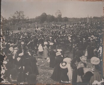
Photograph - GATHERING OF PEOPLE, c1900s
... On the right side of the photo there is a monument, possibly for a grave, a picket fence runs along the back of the crowd. Could be the Bendigo or Eaglehawk cemetery. ...cemetery H J G Biggs Health Inspector Black and white photo. Large gathering of people of all ages including children, appear to be dressed for a funeral. In the centre there a group of people who appear to be conducting a funeral, some appear to be dressed in Free Masons clothing or Rechabite, four men are holding poles, two are wearing Free Masons bibs. To the left of the photo are what appears to be mounds from fresh graves. On the right side of the photo there is a monument, possibly for a grave, a picket fence ...Black and white photo. Large gathering of people of all ages including children, appear to be dressed for a funeral. In the centre there a group of people who appear to be conducting a funeral, some appear to be dressed in Free Masons clothing or Rechabite, four men are holding poles, two are wearing Free Masons bibs. To the left of the photo are what appears to be mounds from fresh graves. On the right side of the photo there is a monument, possibly for a grave, a picket fence runs along the back of the crowd. Could be the Bendigo or Eaglehawk cemetery. Possibly early 20th century Markings/Inscriptions: H J G Biggs, Health Inspector. Picture Funeral 6A.place, cemetery, cemetery, h j g biggs, health inspector -
 Bendigo Historical Society Inc.
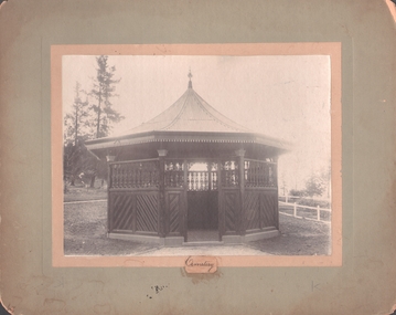
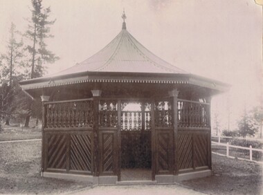
Photograph - WHITEHILLS CEMETERY ROTUNDA
... fence on right side. Inscription: On front at bottom of image, !.3 x 2 cm piece of paper glued to board, hand written 'Cemetery'. ...Cemetery rotunda B+W Photo on fawn board. Ornate Rotunda. Diagonal timber insert on bottom. Cast iron lace on top and lace work on eaves. Decorative finial to roof line. Tessellated tiles on floor. White fence ...B+W Photo on fawn board. Ornate Rotunda. Diagonal timber insert on bottom. Cast iron lace on top and lace work on eaves. Decorative finial to roof line. Tessellated tiles on floor. White fence on right side. Inscription: On front at bottom of image, !.3 x 2 cm piece of paper glued to board, hand written 'Cemetery'. On back, hand written in ballpoint pen, 'Royal Historical Society of Vic./Bendigo Branch', 'Rotunda/1204/FSP.'. Research: Rotunda at White Hills Cemeteryplace, cemetery, rotunda -
 Bendigo Historical Society Inc.
Photograph - WHITE HILLS CEMETERY VICTORIAN ROTUNDA, 1890's
... fence on right side. Inscription: On front at bottom of image, !.3 x 2 cm piece of paper glued to board, hand written 'Cemetery'. ...fence on right side. Inscription: On front at bottom of image, !.3 x 2 cm piece of paper glued to board, hand written 'Cemetery'. ...B+W Photo on fawn board. Ornate Rotunda. Diagonal timber insert on bottom. Cast iron lace on top and lace work on eaves. Decorative finial to roof line. Tessellated tiles on floor. White fence on right side. Inscription: On front at bottom of image, !.3 x 2 cm piece of paper glued to board, hand written 'Cemetery'. On back, hand written in ballpoint pen, 'Royal Historical Society of Vic./Bendigo Branch', 'Rotunda/1204/FSP.'. Research: Rotunda at White Hills Cemeterywhite hills, white hills cemetewry, rotunda -
 Bendigo Historical Society Inc.
Photograph - HARRY BIGGS COLLECTION: PHOTO OF BOORT CEMETERY
... Coloured Photo of Boort Cemetery. Graves are enclosed with a white fence and a large tree is in the centre. ...History House 11 Mackenzie Street Bendigo goldfields MEMORIALS Graveboards Boort Cemetery Boort Cemetery Coutts family Coloured Photo of Boort Cemetery. Graves are enclosed with a white fence and a large tree is in the centre. ...Coloured Photo of Boort Cemetery. Graves are enclosed with a white fence and a large tree is in the centre. Small and large trees are in the back ground. Photo was taken in 1964. 8.8 Inscription on the back of 2400 411a Early Settlers Cemetery dated 1964. Restoration by Russel Coutts of the graves at the homestead Dunbar, on the site of the old Boort Homestead.memorials, graveboards, boort cemetery, boort cemetery, coutts family -
 Bendigo Historical Society Inc.
Document - HARRY BIGGS COLLECTION: BOORT CEMETERY
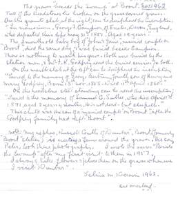
... fence and re- erecting the broken and fallen headstones. S. M. Deravin. (Selina De Ravin) a. Typed poem on carbon copy flimsy paper: 'Beside the Swamp', signed in blue pen by Lina Deravin, January 1957'. Written on the bottom in blue pen: ' In February 1960 when on a visit to Boort I took some flowers and placed them on these graves beside the swamp'. Signed Lina Devarin. Document HARRY BIGGS COLLECTION: BOORT CEMETERY ...Selina Deravin (Born 1882, Serpentine Creek. Died 1968, Melbourne, age 85), father John White, mother Mary Ann Nicholls was married to Garnet Deravin, a medical doctor. In 1928, (Electoral Roll Bendigo) Garnet and Selina were living at 109 Queen Street, Bendigo; later at 13 Tuxon Street, North Balwyn, where Garnet died on 15th. April, 1954 (Argus, 17th April, 1954). Deravin family owned the Chateau Dore vineyard and winery. Selina published a book of her poetry. A poem ' Beside the Swamp' was written following her visit to the swamp at Boort: ' In silence by the graves I stood, of those who long had lain at rest/In lonely quiet, in the bush. Long gone are they who loved them best/The trees still whisper by the swamp; the night birds call, and vigil keep/As in those far-off yesterdays - where Campion and three children sleep........'Selina White Birth Date Abt 1882 Birth Place Serpentine Creek, Victoria Registration Year 1882 Registration Place Victoria, Australia Father John White Mother Aary Ann Nicholls Registration Number 25736 Hand written letter by Selina De Ravin, titled 'The graves beside the swamp at Boort.' dated November 1962. Two of the headstones lie broken on the grass covered graves. On the granite slab at the right is the inscription 'In memoriam. George F. Campion of Exeter Devon, England, who departed this life, May 31st 1851. Aged 19 years. The 2 month old baby boy of 'John and Jane', married couple on 'Boort', died the same day and was buried beside Campion. There is nothing to mark his grave. Both were buried by the Station men. Mr J. R. Godfrey read the burial services for both. On the marble slab at the left can be deciphered the inscription sacred to the memory of George Bertram, fourth son of Henry and Mary Godfrey, Born 18th November 1858. Died 11th April 1860. On the headstone still standing can be read the inscription Sacred to the memory of Samuel C. Sutlee, who died April 1st 1871, aged 2 years 4 months. He is not dead - but sleepeth. This child was the son of a married couple 'on Boort', after the Godfrey family had left 'Boort'. Note - My nephew Russell Coutts of 'Dunbar', Boort, (formerly 'Boort' Station) is erecting a fence around the graves. His son, Peter took these photographs. I wrote the verses 'Beside the Swamp' after my first visit to them in 1957. I always take flowers and place them on the graves whenever I visit 'Dunbar' Selina M. Deravin 1962Russell Coutts and his son Peter have restored the graves beside the Lake at 'Dunbar' and erected a graveyard. This photograph was taken by Peter and the flowers placed on the graves by his mother Wilma who helps to care for them. They also discovered a fifth unknown grave there when erecting the fence and re- erecting the broken and fallen headstones. S. M. Deravin. (Selina De Ravin) a. Typed poem on carbon copy flimsy paper: 'Beside the Swamp', signed in blue pen by Lina Deravin, January 1957'. Written on the bottom in blue pen: ' In February 1960 when on a visit to Boort I took some flowers and placed them on these graves beside the swamp'. Signed Lina Devarin.Selina M. Deravinmemorials, graveboards, boort cemetry, russell coutts, 'dunbar', peter coutts, george f. campion, boort cemetery, samuel c. sutlee?., poetry, poem, garnet deravin, selina deravin -
 Bendigo Historical Society Inc.
Photograph - BOTANICAL GARDENS
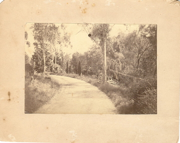
... fence middle distance. Pathway curving to left from front of photo. Written in blue pen on rear of photo : Botanical Gardens or early path in Fortuna. English trees planted, e.g. cypress. Holdsworth Road, adj. White Hills Cemetery...fence middle distance. Pathway curving to left from front of photo. Written in blue pen on rear of photo : Botanical Gardens or early path in Fortuna. English trees planted, e.g. cypress. Holdsworth Road, adj. White Hills Cemetery ...sepia photograph on cream board. Driveway/pathway, gravelled, eucalypt and conifer trees, uncut grass, wire fence middle distance. Pathway curving to left from front of photo. Written in blue pen on rear of photo : Botanical Gardens or early path in Fortuna. English trees planted, e.g. cypress. Holdsworth Road, adj. White Hills Cemetery Reserve. Crowned road grade. Heavy intermediate fence posts.unknownplace, land, botanical gardens, fortuna ? -
 Eltham District Historical Society Inc
Photograph, Edendale Farm, Eltham Heritage Tour, 24 May 1992
... fence - bulbous tree-trunks decorated with salt pots, with cross members from the old trestle bridge. As was usual these six veranda posted houses faced South (or East, away from the sun!) with the scullery, kitchen and pantry "out the back". The veranda, which must have been very narrow, no longer exists. It probably wrapped around three sides. The drive took us past the Dutch Windmill, only twenty years old and in the Shire of Diamond Valley, then the Diamond Creek Cemetery...fence - bulbous tree-trunks decorated with salt pots, with cross members from the old trestle bridge. As was usual these six veranda posted houses faced South (or East, away from the sun!) with the scullery, kitchen and pantry "out the back". The veranda, which must have been very narrow, no longer exists. It probably wrapped around three sides. The drive took us past the Dutch Windmill, only twenty years old and in the Shire of Diamond Valley, then the Diamond Creek Cemetery ...ELTHAM HERITAGE TOUR The Society excursion on 24th May 1992 was arranged by David Bick, leader of the team carrying out the Shire's heritage study. David selected a number of sites or buildings identified in the study, some of them lesser known components of the Shire's heritage. The tour commenced at the Eltham Shire Office at 10.00 am. Travel was by private car and mini-bus with stops at about twelve locations for commentary by David.It included a short walk in Hurstbridge and lunch at Kinglake. Highlights of the tour included: - 10 am Leave from Shire Offices - 3 Important Trees - A Physical Link to Eltham's First Settlers - Toorak Mansion Gates - A Surviving Farm House - An Intact Circa 1900 Main Street - First Settlers - Gold Miners, and Timber-getters - An Early Hotel - A Pioneering Homestead - Changing Eltham Shire - 20th Century - 4 pm Afternoon Tea and Finish Tour Extract from ELTHAM CULTURAL HERITAGE TOUR (Newsletter No. 85, July 1992, by Bettina Woodburn) "The land was unprofitable for intensive farming, but there was always water in the Diamond Creek. The railway, a technological advance, followed the valley, and was provided to transport produce. At North Eltham we were privileged to tour a surviving farmhouse of the 1860-70 era at the Shire’s Edendale Farm, with the as yet unfinished Sculpture for a front fence - bulbous tree-trunks decorated with salt pots, with cross members from the old trestle bridge. As was usual these six veranda posted houses faced South (or East, away from the sun!) with the scullery, kitchen and pantry "out the back". The veranda, which must have been very narrow, no longer exists. It probably wrapped around three sides. The drive took us past the Dutch Windmill, only twenty years old and in the Shire of Diamond Valley, then the Diamond Creek Cemetery with impressive gateway, to a detour to see another old farmhouse, isolated on a hill off Murray Road Wattle Glen. Here was a particularly thick patch of exotic planting of pines and cypresses. Subsistence farming no longer pays. Following the rail-line we noticed on the left near Silvan Road an Edwardian cottage and on the right near Yates Road the old school residence for this Upper Diamond Creek area."Record of the Society's history and activities and highlighting various aspects of the Heritage Study undertaken by David Bick used to create the future heritage overlay for the Shire of Eltham and later Nillumbik Shire.Roll of 35mm colour negative film, 4 strips Associated colour printKodak Gold 100 5095eltham, shire of eltham historical society, activities, heritage tour, 1992, culture, edendale, edendale community farm, events -
 Eltham District Historical Society Inc
Photograph, Edendale Farm, Eltham Heritage Tour, 24 May 1992
... fence - bulbous tree-trunks decorated with salt pots, with cross members from the old trestle bridge. As was usual these six veranda posted houses faced South (or East, away from the sun!) with the scullery, kitchen and pantry "out the back". The veranda, which must have been very narrow, no longer exists. It probably wrapped around three sides. The drive took us past the Dutch Windmill, only twenty years old and in the Shire of Diamond Valley, then the Diamond Creek Cemetery...fence - bulbous tree-trunks decorated with salt pots, with cross members from the old trestle bridge. As was usual these six veranda posted houses faced South (or East, away from the sun!) with the scullery, kitchen and pantry "out the back". The veranda, which must have been very narrow, no longer exists. It probably wrapped around three sides. The drive took us past the Dutch Windmill, only twenty years old and in the Shire of Diamond Valley, then the Diamond Creek Cemetery ...ELTHAM HERITAGE TOUR The Society excursion on 24th May 1992 was arranged by David Bick, leader of the team carrying out the Shire's heritage study. David selected a number of sites or buildings identified in the study, some of them lesser known components of the Shire's heritage. The tour commenced at the Eltham Shire Office at 10.00 am. Travel was by private car and mini-bus with stops at about twelve locations for commentary by David.It included a short walk in Hurstbridge and lunch at Kinglake. Highlights of the tour included: - 10 am Leave from Shire Offices - 3 Important Trees - A Physical Link to Eltham's First Settlers - Toorak Mansion Gates - A Surviving Farm House - An Intact Circa 1900 Main Street - First Settlers - Gold Miners, and Timber-getters - An Early Hotel - A Pioneering Homestead - Changing Eltham Shire - 20th Century - 4 pm Afternoon Tea and Finish Tour Extract from ELTHAM CULTURAL HERITAGE TOUR (Newsletter No. 85, July 1992, by Bettina Woodburn) "The land was unprofitable for intensive farming, but there was always water in the Diamond Creek. The railway, a technological advance, followed the valley, and was provided to transport produce. At North Eltham we were privileged to tour a surviving farmhouse of the 1860-70 era at the Shire’s Edendale Farm, with the as yet unfinished Sculpture for a front fence - bulbous tree-trunks decorated with salt pots, with cross members from the old trestle bridge. As was usual these six veranda posted houses faced South (or East, away from the sun!) with the scullery, kitchen and pantry "out the back". The veranda, which must have been very narrow, no longer exists. It probably wrapped around three sides. The drive took us past the Dutch Windmill, only twenty years old and in the Shire of Diamond Valley, then the Diamond Creek Cemetery with impressive gateway, to a detour to see another old farmhouse, isolated on a hill off Murray Road Wattle Glen. Here was a particularly thick patch of exotic planting of pines and cypresses. Subsistence farming no longer pays. Following the rail-line we noticed on the left near Silvan Road an Edwardian cottage and on the right near Yates Road the old school residence for this Upper Diamond Creek area."Record of the Society's history and activities and highlighting various aspects of the Heritage Study undertaken by David Bick used to create the future heritage overlay for the Shire of Eltham and later Nillumbik Shire.Roll of 35mm colour negative film, 4 strips Colour printKodak Gold 100 5095eltham, shire of eltham historical society, activities, heritage tour, 1992, culture, edendale, edendale community farm, events -
 Eltham District Historical Society Inc
Photograph, Edendale Farm, Eltham Heritage Tour, 24 May 1992, 24/05/1992
... fence - bulbous tree-trunks decorated with salt pots, with cross members from the old trestle bridge. As was usual these six veranda posted houses faced South (or East, away from the sun!) with the scullery, kitchen and pantry "out the back". The veranda, which must have been very narrow, no longer exists. It probably wrapped around three sides. The drive took us past the Dutch Windmill, only twenty years old and in the Shire of Diamond Valley, then the Diamond Creek Cemetery...fence - bulbous tree-trunks decorated with salt pots, with cross members from the old trestle bridge. As was usual these six veranda posted houses faced South (or East, away from the sun!) with the scullery, kitchen and pantry "out the back". The veranda, which must have been very narrow, no longer exists. It probably wrapped around three sides. The drive took us past the Dutch Windmill, only twenty years old and in the Shire of Diamond Valley, then the Diamond Creek Cemetery ...ELTHAM HERITAGE TOUR The Society excursion on 24th May 1992 was arranged by David Bick, leader of the team carrying out the Shire's heritage study. David selected a number of sites or buildings identified in the study, some of them lesser known components of the Shire's heritage. The tour commenced at the Eltham Shire Office at 10.00 am. Travel was by private car and mini-bus with stops at about twelve locations for commentary by David.It included a short walk in Hurstbridge and lunch at Kinglake. Highlights of the tour included: - 10 am Leave from Shire Offices - 3 Important Trees - A Physical Link to Eltham's First Settlers - Toorak Mansion Gates - A Surviving Farm House - An Intact Circa 1900 Main Street - First Settlers - Gold Miners, and Timber-getters - An Early Hotel - A Pioneering Homestead - Changing Eltham Shire - 20th Century - 4 pm Afternoon Tea and Finish Tour Extract from ELTHAM CULTURAL HERITAGE TOUR (Newsletter No. 85, July 1992, by Bettina Woodburn) "The land was unprofitable for intensive farming, but there was always water in the Diamond Creek. The railway, a technological advance, followed the valley, and was provided to transport produce. At North Eltham we were privileged to tour a surviving farmhouse of the 1860-70 era at the Shire’s Edendale Farm, with the as yet unfinished Sculpture for a front fence - bulbous tree-trunks decorated with salt pots, with cross members from the old trestle bridge. As was usual these six veranda posted houses faced South (or East, away from the sun!) with the scullery, kitchen and pantry "out the back". The veranda, which must have been very narrow, no longer exists. It probably wrapped around three sides. The drive took us past the Dutch Windmill, only twenty years old and in the Shire of Diamond Valley, then the Diamond Creek Cemetery with impressive gateway, to a detour to see another old farmhouse, isolated on a hill off Murray Road Wattle Glen. Here was a particularly thick patch of exotic planting of pines and cypresses. Subsistence farming no longer pays. Following the rail-line we noticed on the left near Silvan Road an Edwardian cottage and on the right near Yates Road the old school residence for this Upper Diamond Creek area."Record of the Society's history and activities and highlighting various aspects of the Heritage Study undertaken by David Bick used to create the future heritage overlay for the Shire of Eltham and later Nillumbik Shire.Roll of 35mm colour negative film, 4 stripsKodak Gold 100 5095eltham, shire of eltham historical society, activities, heritage tour -
 Victorian Interpretive Projects Inc.
Photograph - Colour, Clare Gervasoni, Ebenezer Mission, Antwerp, 2013, 2013
... cemetery includes hundreds of unmarked burials. In 1961 the National Trust (Victoria) received a letter from the Horsham Historical Society expressing concern for the future of the Mission buildings. By 1971 the National Trust was managing the site. It was fenced...cemetery includes hundreds of unmarked burials. In 1961 the National Trust (Victoria) received a letter from the Horsham Historical Society expressing concern for the future of the Mission buildings. By 1971 the National Trust was managing the site. It was fenced ...The Ebenezer Mission Station is situated by the Wimmera River and was established by Moravian missionaries as the Lake Hindmarsh Aboriginal Reserve in 1859. At its peak more than 100 people lived and worked on the mission in more than 20 buildings. The Mission closed in 1900 and was returned to the Lands Department in 1904. The church was established in the 1870s and the cemetery includes hundreds of unmarked burials. In 1961 the National Trust (Victoria) received a letter from the Horsham Historical Society expressing concern for the future of the Mission buildings. By 1971 the National Trust was managing the site. It was fenced, connected to power and the church was restored. In the mid-1970s the gravestones were in a bad state of repair. Stonemason James McCauley worked on the stones for 2 weeks. In 1991 the church was handed over to the Goolum Goolum Aboriginal Co-operative to manage. On 05 December 2013 the National Trust handed over the freehold of the Mission site. Moravian missionary Revd Paul Bogisch and his wife Amalie are buried in the cemetery. A number of colour digital photographs showing buildings on the former Ebenezer Mission at Antwerp.ebenezer, bogisch, goolum goolum, goolum, national trust, national trust (victoria), lake hindmarsh, lake hindmarsh aboriginal reserve, moravian, mission, missionary -
 Bendigo Historical Society Inc.
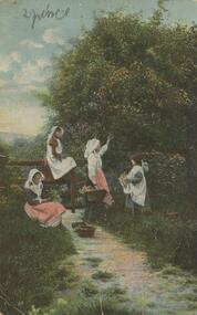
Postcard - Alice McGregor Postcard Collection, 1900 - 1920
... Cemetery See additional research. Postcard Album of Alice McGregor contained 86 post cards. POSTCARD Collector Alice McGregor Addressed to Miss A. Stapleton, Arcade, Bendigo Sender - not given PO Dated 21.8.05, Bendigo Postcard Album of Alice McGregor containing 86 post cards. See 1400 Colour photo of four women collecting flowers from a tree. One sitting on ground and one sitting on a fence ...Alice McGREGOR Born: 1908; unknown parents. Possibly adopted by the Salter family? Electoral Roll 1936: Highland Terrace Kangaroo Flat. Alice Mary Salter and William Robert Salter living together; presumed to be sister and brother. William Robert Salter was killed in a MVA in Bendigo in 1937 aged 26. In Victoria in 1938, Alice Mary Salter married James Thomas McGregor (born Victoria 1917, died Victoria 1983, buried Fawkner Cemetery) Lived: 1968; 22 Wade Street Golden Square Alice McGregor Died: 1999 aged 91 at Anne Caudle Centre, Bendigo Buried: Kangaroo Flat Cemetery See additional research. Postcard Album of Alice McGregor contained 86 post cards.Postcard Album of Alice McGregor containing 86 post cards. See 1400 Colour photo of four women collecting flowers from a tree. One sitting on ground and one sitting on a fence. Addressed to Miss A. Stapleton, Arcade, Bendigo Sender - not given PO Dated 21.8.05, Bendigo postcard, collector, alice mcgregor -
 Bendigo Historical Society Inc.
Document - SANDHURST BURIAL GROUNDS
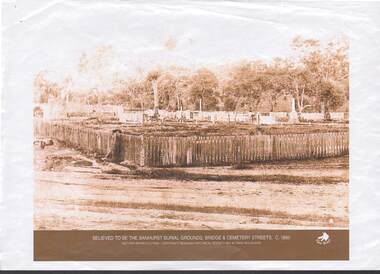
... History House 11 Mackenzie Street Bendigo goldfields BENDIGO History cemetery Photocopy images a,b, believed to be of Sandhurst Burial Grounds, and overlooking fence looking East, Bridge Street C 1860. ...Photocopy images a,b, believed to be of Sandhurst Burial Grounds, and overlooking fence looking East, Bridge Street C 1860. Copyright Bendigo Historical Society & David Mulqueen.bendigo, history, cemetery -
 Bendigo Historical Society Inc.
Photograph - PHOTOGRAPH OF GRAVES
... CEMETERY Photograph of Graves ? Downes ? Downes, Bedford Small, pale photograph of graves. There are three graves in the photo. The one on the left is a large, flat plain one. Behind it is a large one with an iron lace fence ...Small, pale photograph of graves. There are three graves in the photo. The one on the left is a large, flat plain one. Behind it is a large one with an iron lace fence with a chain above it around a high tombstone and the third one is a smaller one with a decorative railing around the edge. Behind the graves is a hedge and behind the hedge is a church.? Downes, Bedfordcemetery, photograph of graves, ? downes -
 Bendigo Historical Society Inc.
Photograph - WES HARRY COLLECTION: WHITE HILLS CEMETERY, 1860's
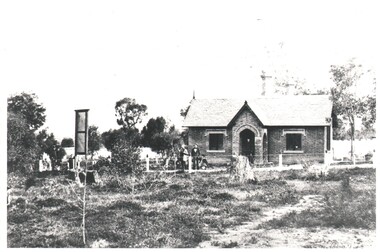
... At the White Hills Cemetery, it is in a single storied brick structure in a bush land setting. There is a noticeboard on the left of the photo and a post and wire fence along the front of the building . ...At the White Hills Cemetery, it is in a single storied brick structure in a bush land setting. There is a noticeboard on the left of the photo and a post and wire fence along the front of the building . ...Photograph of the Chapel ? At the White Hills Cemetery, it is in a single storied brick structure in a bush land setting. There is a noticeboard on the left of the photo and a post and wire fence along the front of the building . One person is standing in the doorway and two adults and a small child to the left. There are three more adults on the extreme left hand side , near the entrance to the cemetery.Batchelderplace, cemetery, white hills cemetery, white hills cemetery, batchelder -
 Bendigo Historical Society Inc.
Photograph - WES HARRY COLLECTION: BENDIGO CEMETERY, 1860's
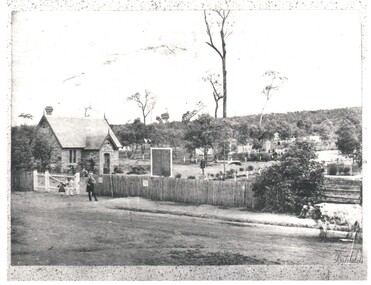
... Cemetery showing some headstones among the trees. Caretakers cottage ?, Chapel ?, on the left of the shot with some children and an older man in front. There is a picket fence...Cemetery showing some headstones among the trees. Caretakers cottage ?, Chapel ?, on the left of the shot with some children and an older man in front. There is a picket fence ...Photograph of the Bendigo Cemetery showing some headstones among the trees. Caretakers cottage ?, Chapel ?, on the left of the shot with some children and an older man in front. There is a picket fence along the front of the cemetery and a cow standing on the roadway at the right hand edge of the photo.Batchelderplace, cemetery, bendigo cemetery, carpenter street, bendigo cemetery, batchelder -
 City of Moorabbin Historical Society (Operating the Box Cottage Museum)
Photograph, 2 B&W, 1898 The O'Maras', Sandringham Fishermen : Date Unknown, Mud Brick House, 1898 The O'Maras', Sandringham Fishermen Date Unknown, Mud Brick House, 1898
... Cemetery Road ). About 12 years ago there was a vacant block where the house used to be and it was next to an electrical factory. unsigned undated 2x Black and White Photographs. (i) An 1898 photograph showing two men with a fishing boat on the beach. A beach house / shed , paling fence ...The O'Maras, of Sandringham fishermen. Early mud brick house. Located in Moorabbin and was still there in 1940. The house was situated in Reserve Road, almost opposite Wangara Road, (formerly Cemetery Road). About twelve years ago, (* the writer states no year), there was a vacant block where the house used to be - it was next to a electrical factory. 2x Black and White Photographs. (i) An 1898 photograph showing two men with a fishing boat on the beach. A beach house / shed , paling fence and tall tea-trees are seen in the background. (ii) A large early mud brick house with a tin roof, chimney and a water tank sitting on a block of grassed landWritten on back (i) The O'Maras / Sandringham / fishermen 1898 (ii) Mud brick house at Moorabbin ( house was there in 1940) / Situated in Reserve Road almost opposite Wangara Road / ( formerly Cemetery Road ). About 12 years ago there was a vacant block where the house used to be and it was next to an electrical factory. unsigned undatedthe o'maras, sandringham fisherman, 1898, mud brick house, moorabbin, wangara road, reserve road, electrical factory, early settlers, pioneers, shire of moorabbin, sandringham, beaumaris, mentone, fishermen, dairy farmaers, poultry farmers, market gardeners, -
 Glenelg Shire Council Cultural Collection
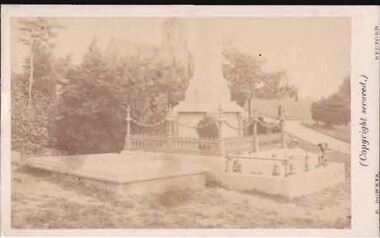
Photograph - Photograph - South Portland Cemetery, n.d
... Cemetery. Granite monument with urn on top, surrounded by wrought iron fence. Inscription unreadable...Cemetery. Granite monument with urn on top, surrounded by wrought iron fence. Inscription unreadable Photograph Photograph - South Portland Cemetery ...Alexander Davidson arrived in Australia in 1838 as a poor Scotsman, a mason by trade. Alexander was to work hard and amass enough savings to allow him to invest in an established Squatting Run in 1848. As stated in his obituary "by patient industry and perseverance acquired considerable wealth as a squatter on the Satima station, near Casterton" on the Wando River in Victoria. He was at first a part-owner of the Satimer Run with his brother-in-law Duncan Robertson, but was able to buy out his brother-in-law's share in 1860. In 1864, with proceeds of his squatting income, he built a two storey stucco rendered bluestone house in Portland which he called "Wando Villa", which is today a Heritage Listed Building.Black and white photo. Alexander Davidson's grave, South Portland Cemetery. Granite monument with urn on top, surrounded by wrought iron fence. Inscription unreadableBack: 'ALEXANDER DAVIDSON'S GRAVE SOUTH PORTLAND CEMETERY, PORTLAND VICTORIA 1971' - hand printed, black biro Purple stamp 'ALEX PRIESTLEY BOX 155 PHONE 309 HEYWOOD VIC 3304squatter, squattocracy