Showing 48 items matching "fire trails"
-
 National Vietnam Veterans Museum (NVVM)
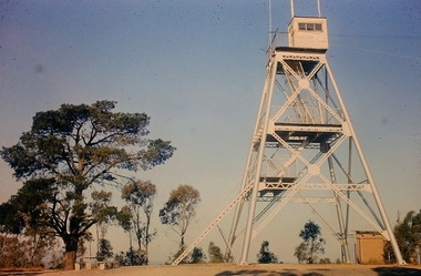
Photograph, Gibbons, Denis, Fortified Base Camp
... ...Fire Trails...A coloured photograph of a fortified base camp alongside an Australian Fire Support Base, houses engineers involved in the construction of 'fire trails' which were cut through dense jungle of known infiltration, to cut NVA/VietCong lines of communications and supply (circa April 1969)...Photograph Fire Support Base Gibbons Collection Catalogue NVA/VC Fire Trails Jungle NVA Viet Cong Denis Gibbons A coloured photograph of a fortified base camp alongside an Australian Fire Support Base, houses engineers involved in the construction of 'fire trails' which were cut through dense jungle of known infiltration, to cut NVA/VietCong lines of communications and supply (circa April 1969) Fortified Base Camp Photograph Gibbons, Denis ...Denis Gibbons (1937 – 2011) Trained with the Australian Army, before travelling to Vietnam in January 1966, Denis stayed with the 1st Australian Task Force in Nui Dat working as a photographer. For almost five years Gibbons toured with nine Australian infantry battalions, posting compelling war images from within many combat zones before being flown out in late November 1970 after sustaining injuries. The images held within the National Vietnam Veterans Museum make up the Gibbons Collection. A coloured photograph of a fortified base camp alongside an Australian Fire Support Base, houses engineers involved in the construction of 'fire trails' which were cut through dense jungle of known infiltration, to cut NVA/VietCong lines of communications and supply (circa April 1969)photograph, fire support base, gibbons collection catalogue, nva/vc, fire trails, jungle, nva viet cong, denis gibbons -
 Wangaratta High School
WSC Yearbook -Geronimo, 1998
... Black yearbook with a full-page image of a girl surrounded by circular fire trails. Coloured writing advertises the contents of the issue and the heading reads Geronimo '98 THE YEAR IN REVIEW...Artwork Writing Photography The School gets a makeover SPORTS UPDATE Wangaratta Secondary College, The end of an Era A special report from principal, Mr Pech Black yearbook with a full-page image of a girl surrounded by circular fire trails. Coloured writing advertises the contents of the issue and the heading reads Geronimo '98 THE YEAR IN REVIEW WSC Yearbook -Geronimo ...Black yearbook with a full-page image of a girl surrounded by circular fire trails. Coloured writing advertises the contents of the issue and the heading reads Geronimo '98 THE YEAR IN REVIEWGeronimo '98 THE YEAR IN REVIEW INSIDE: Check out our FULL COLOUR centrefold! Artwork Writing Photography The School gets a makeover SPORTS UPDATE Wangaratta Secondary College, The end of an Era A special report from principal, Mr Pech -
 Beechworth Honey Archive
Map- Albury
... Sheet 8225 (ed.1) series R. 652 Notes written on side regarding brigade boundaries, constructed access roads and fire trails, dams suitable for quick fill pump and areas 'fuel reduction burns Autumn 76'....Beechworth Honey Archive 87 Ford Street Beechworth high-country Map Albury Wodonga Beechworth Yackandandah Chiltern Paper Topographic Beechworth Honey Sheet 8225 (ed.1) series R. 652 Notes written on side regarding brigade boundaries, constructed access roads and fire trails, dams suitable for quick fill pump and areas 'fuel reduction burns Autumn 76'. ...Map centred on Albury, showing Wodonga, Beechworth, Yackandandah and Chiltern. Topographic survey scale 1:100,000. Map is colour, printed on paper. Produced by Department of Minerals and EnergySheet 8225 (ed.1) series R. 652 Notes written on side regarding brigade boundaries, constructed access roads and fire trails, dams suitable for quick fill pump and areas 'fuel reduction burns Autumn 76'.map, albury, wodonga, beechworth, yackandandah, chiltern, paper, topographic, beechworth honey -
 Kiewa Valley Historical Society
Video - Fainter Falls, Fainter Falls, 2003 - 2008
... fainter falls. bogong. walking trail. fire track. national parks of victoria...The trail was originally accessible via a fire fighting access trail. ...The trail was originally accessible via a fire fighting access trail. ...Visual workings and development of the Fainter Falls Trail completed in 2008. The trail was originally accessible via a fire fighting access trail. The fire in the summer of 2003 highlighted the beauty of the area and provided the residents of the Kiewa Valley with the opportunity to consider the redevelopment of the trail. Work to establish a 700 metre grade 2 walking trail with a 50 metre grade 3 extension trail to the Falls began in 2005. It also includes 3 observation decks, a bridge over a creek crossing, car parking and interpretive signage.This video recording is a visual recording of the process of the establishment of the Fainter Falls Walking Trail giving an insight into the process, the work, tools and materials used for such work from 2003 to 2008. It also shows the vegetation in the area and the amount of water flowing at the time.White cardboard cover with black plastic video labelled "Fainter Falls" on outer edge."Fainter Falls"fainter falls. bogong. walking trail. fire track. national parks of victoria -
 Falls Creek Historical Society
Clothing - Cycling Shirt - McKayos Mountain Bike Ride, 2016
... Riders tackled snow, village roads, fire trails, and singletrack across an 18km course. ...Riders tackled snow, village roads, fire trails, and singletrack across an 18km course. ...In 2015, the Marketing, Events, and Operations teams at Falls Creek launched McKayos—a bold, one-of-a-kind race designed to showcase the resort's trails to winter visitors. Inspired by the legendary Megavalanche in the French Alps, McKayos was a mass-start descent from the summit of Mt McKay (1,850m) to the edge of Lake Bogong, over 1,200m below. Riders tackled snow, village roads, fire trails, and singletrack across an 18km course. With the support of the Lift Company, competitors and bikes were transported up the Falls Express chairlift before climbing to the summit start line. In later years, the race began at the Ski Patrol base. Held for five consecutive years, McKayos grew to attract up to 450 participants, cementing itself as a legendary event in Australian mountain biking history. This shirt is from the 2016 event when the winners were:- Open Men: Paul van der Ploeg (1st), Sebastian Jayne (2nd). Women: Lisa Brydon (1st), Julia Clark (2nd) Junior Men: Ben McIlroy (1st) Casey Griska (2nd) Jo Prothero, Director of Marketing for Falls Creek Resort Management from 2012 to 2019, generously donated two mountain bike jerseys that capture a pivotal era in the resort's history. During Jo's tenure, the resort made significant investments in mountain bike trails, aiming to activate the village during the summer months and support local businesses. This development included appointing Blue Dirt as the resort's first shuttle operator, transporting riders from Howman's Gap to the Summit.This shirt is significant because it represents an important and innovative event held at Falls Creek Victoria.A green and gold cyclist shirt featuring the logo of the McKayos Mountain Bike Ride. It also has a mountain bike on the front in black. The Mckayos logo in on the upper left. The back features the words SNOW, DIRT, ROAD as well as sponsors' logos and "Falls Creek Victoria and the manufacturer, Sacul Sportswear of Mount Beauty, Victoria. McKayos is on the right sleeve and 2016 is on the left sleeve.mckayos mountain bike ride, falls creek activities, falls creek victoria -
 Kiewa Valley Historical Society
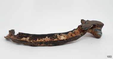
Shovel head - Fainter Falls
... The Fainter Falls Walking Track was originally accessible via a fire fighting access trail, which was used by fire-fighters putting out spot fires caused by lightening strikes. ...Kiewa Valley Historical Society Mount Beauty Information Centre 31 Bogong High Plains Rd Mt Beauty high-country The Fainter Falls Walking Track was originally accessible via a fire fighting access trail, which was used by fire-fighters putting out spot fires caused by lightening strikes. ...The Fainter Falls Walking Track was originally accessible via a fire fighting access trail, which was used by fire-fighters putting out spot fires caused by lightening strikes. The fires in the summer of 2003, highlighted the beauty of this area and provided the residents with the opportunity to consider the redevelopment of the trail. Work to establish a 700 metre grade 2 walking trail with a 50 metre grade 3 extension trail to the Falls began in 2005. It also includes 3 observation decks, a bridge over a creek crossing, car parking and interpretative signage.The shovel was found during work on the Fainter Falls track. It was left there some time ago by a previous visitor to the Falls indicating that the Falls were accessible and attracted visitors many years ago.Rusty metal shovel head curved on each side and rounded at the front. At the back of the blade it is attached on top with 3 nails to the top piece. The top metal piece overlaps the blade by 6.5 cm longitudinally x 5 cm across. On the back the metal piece overlaps the blade by 12 cm both longitudinally and across the handle end but tapers to a point. It has 6 nails attaching it. Both metal pieces are attached to the blade and curve parallel and around so that a wooden handle would fit between them. This would have 2 nails passing through both metal pieces and the handle. (The handle is missing.) shovel. fainters falls. bogong. walking track. fire track. water. -
 Kiewa Valley Historical Society
Folder - Fainter Falls, 2003 - 2008
... fainter falls. bogong. walking trail. fire track. kiewa valley community....The Fainter Falls Walking Track was originally accessible via a fire fighting access trail, which was used by fire fighters putting out spot fires caused by lightening strikes. ...Kiewa Valley Historical Society Mount Beauty Information Centre 31 Bogong High Plains Rd Mt Beauty high-country The Fainter Falls Walking Track was originally accessible via a fire fighting access trail, which was used by fire fighters putting out spot fires caused by lightening strikes. ...The Fainter Falls Walking Track was originally accessible via a fire fighting access trail, which was used by fire fighters putting out spot fires caused by lightening strikes. The fires in the summer of 2003 highlighted the beauty of the area and provided the residents with the opportunity to consider the redevelopment of the trail. Work to establish a 700 metre grade 2 walking trail with a 50 metre grade 3 extension trail to the Falls began in 2005. It also includes 3 observation decks, a bridge over a creek crossing, car parking and interpretive signage.A Friends of Fainter Falls committee was formed to work towards the construction of a track to Fainter Falls. The contents of this folder is evidence of how a local community achieved its goals for such a project in 2003 - 2008.Large orange lever arch folder bound with 2 rings. Contains the history of the redevelopment of the Fainter Falls track 2003 - completion at the end of 2008. It is divided into: Funding Proposals. Correspondence Inwards & Outwards. Minutes and Letters of Support. Inserted separately in a large white and yellow Express Post envelope is additional information including chronology, minutes, newspaper cuttings Inserted separately is the 'Small Towns Development Fund' Application Form 2006.Cover blankfainter falls. bogong. walking trail. fire track. kiewa valley community. -
Marysville & District Historical Society
THE TRIANGLE NEWS-VOL 39 NO 36-SEPTEMBER 21 2012
... Marysville & District Historical Society 39 Darwin Street Marysville yarra-valley-and-the-dandenong-ranges marysville victoria australia opera in marysville oz opera don giovanni opera comes to marysville bushwalking back in marysville marysville lions club what's on when in september intrepid triangle bushwalkers lantern making workshop marysville community market marysville cfa-first aid course level 1 council lobbies for support payment advertisements marysville golf report church notices fire season-slashing program buxton primary school triangle garden club events marysville golf club murrindindi shire council amnesty period on open aire burning marysville chamber of commerce triangle shared trails project taggerty community project meeting creative triangle position vacant-parks officer dalton fiske foundation triangle community dancers alexandra library september events real estate buxton reserve news narbethong reserve news cfa calls for victorians to register burn offs habitat for humanity public information meeting alexandra & district ambulance support council joins calling for defined super exemptions triangle community dinner mayor's chair marysville sparkling wine festival victorian concert orchestra narbethong community hall narbethong community garage sale THE TRIANGLE NEWS-VOL 39 NO 36-SEPTEMBER 21 2012 ...marysville, victoria, australia, opera in marysville, oz opera, don giovanni opera comes to marysville, bushwalking back in marysville, marysville lions club, what's on when in september, intrepid triangle bushwalkers, lantern making workshop, marysville community market, marysville cfa-first aid course level 1, council lobbies for support payment, advertisements, marysville golf report, church notices, fire season-slashing program, buxton primary school, triangle garden club events, marysville golf club, murrindindi shire council, amnesty period on open aire burning, marysville chamber of commerce, triangle shared trails project, taggerty community project meeting, creative triangle, position vacant-parks officer, dalton fiske foundation, triangle community dancers, alexandra library september events, real estate, buxton reserve news, narbethong reserve news, cfa calls for victorians to register burn offs, habitat for humanity, public information meeting, alexandra & district ambulance support, council joins calling for defined super exemptions, triangle community dinner, mayor's chair, marysville sparkling wine festival, victorian concert orchestra, narbethong community hall, narbethong community garage sale -
Marysville & District Historical Society
THE TRIANGLE NEWS-VOL 38 NO 13-APRIL 29 2011
... Marysville & District Historical Society 39 Darwin Street Marysville yarra-valley-and-the-dandenong-ranges marysville victoria australia beeches trail parks victoria meeting of the waters lush rainforest lady talbot drive phantom falls cambarville cathedral range state park community walks whitefoot dunnart dse camera survey points set up lake eildon national park gallipoli park reopens the reflective garden victorian bushfire appeal fund gallipolli park committee of management advertisements buxton silver gum secrets revealed by fires council to hold budget meeting murrindindi shire council THE TRIANGLE NEWS-VOL 38 NO 13-APRIL 29 2011 ...marysville, victoria, australia, beeches trail, parks victoria, meeting of the waters, lush rainforest, lady talbot drive, phantom falls, cambarville, cathedral range state park, community walks, whitefoot dunnart, dse, camera survey points set up, lake eildon national park, gallipoli park reopens, the reflective garden, victorian bushfire appeal fund, gallipolli park committee of management, advertisements, buxton silver gum secrets revealed by fires, council to hold budget meeting, murrindindi shire council -
Marysville & District Historical Society
THE TRIANGLE NEWS-VOL 38 NO 16-MAY 20 2011
... trail...photographic competition...council community services...advertisements...cfa operations...fire...Marysville & District Historical Society 39 Darwin Street Marysville yarra-valley-and-the-dandenong-ranges marysville victoria australia local architecture shortlisted in state awards victorian architecture award regional prize marysville rebuilding advisory centre yea kinglake bushfire memorial concepts church notices murrindindi shire council blumes fashions heritage trail photographic competition council community services advertisements cfa operations fire risk narbethong history group history book of narbethong black saturday fires marysville golf report marysville villains veterans football THE TRIANGLE NEWS-VOL 38 NO 16-MAY 20 2011 ...marysville, victoria, australia, local architecture shortlisted in state awards, victorian architecture award regional prize, marysville rebuilding advisory centre, yea, kinglake, bushfire memorial concepts, church notices, murrindindi shire council, blumes fashions, heritage trail, photographic competition, council community services, advertisements, cfa operations, fire risk, narbethong history group, history book of narbethong, black saturday fires, marysville golf report, marysville villains, veterans football -
Marysville & District Historical Society
THE TRIANGLE NEWS-VOL 38 NO 45-DECEMBER 9 2011
... trail...matdg...community recovery committee...yarra valley practitioners project awards...yvpp...abc radio and weekly times...fire...Marysville & District Historical Society 39 Darwin Street Marysville yarra-valley-and-the-dandenong-ranges marysville victoria australia opening of marysville triangle heritage trail matdg community recovery committee yarra valley practitioners project awards yvpp abc radio and weekly times fire awareness awards cfa dse fire danger restrictions bmx track skate park basketball half court marysville & district lions club THE TRIANGLE NEWS-VOL 38 NO 45-DECEMBER 9 2011 ...marysville, victoria, australia, opening of marysville triangle heritage trail, matdg, community recovery committee, yarra valley practitioners project awards, yvpp, abc radio and weekly times, fire awareness awards, cfa, dse, fire danger restrictions, bmx track, skate park, basketball half court, marysville & district lions club -
Marysville & District Historical Society
THE TRIANGLE NEWS-VOL 38 NO 47-DECEMBER 23 2011
... trail construction...important notice gallipoli park...committee of management...pans on fire...Marysville & District Historical Society 39 Darwin Street Marysville yarra-valley-and-the-dandenong-ranges marysville victoria australia merry christmas and happy new year what's on when marysville community market creative triangle narbethong leads triangle trail construction important notice gallipoli park committee of management pans on fire group cd launch mops THE TRIANGLE NEWS-VOL 38 NO 47-DECEMBER 23 2011 ...marysville, victoria, australia, merry christmas and happy new year, what's on when, marysville community market, creative triangle, narbethong leads triangle trail construction, important notice gallipoli park, committee of management, pans on fire group cd launch, mops -
 Flagstaff Hill Maritime Museum and Village
Functional object - Pulley Sheave, Russell & Co, 1888
... firing off shells and rockets, but his story was passed off as a joke. These rockets were most likely the distress signals from the stricken ship. The Italian barque/clipper Antares was sometime later reported as overdue. The wreck of the ship was later found at the base of a cliff at the Bay of Islands near Warrnambool in November 1914, there were no survivors. The Antares is significant as it was a sail trader carrying an international inbound cargo during the early part of the 20th century. It is part of the Great Ocean Road Historic Shipwreck Trail ...This ship's pully sheave was part of the Antares rigging. A pulley sheave is a circle on a shaft that is manufactured to hold up movement and change of way of a cable or/and rope, or transfer of power between the shaft and cable or/and rope. A pulley is a unique mechanism that is used to leverage the lifting of heavy loads to required heights. The Italian barque Antares was an iron three-masted sailing clipper built in 1888 by Russell & Co of Port Glasgow originally named the “Sutlej” and renamed in 1907 the “Antares” when sold to the Semider Bros of Genoa Italy. The vessel left Marseilles on the 18th of December 1913 with its master captain Gazedo destined for Mullaly & Byrne of Melbourne with a cargo of roofing tiles but failed to arrive. The wreckage was found near the Bay of Islands twenty-two miles east of Warrnambool after a body had washed ashore. Some of the timbers washed up were charred by fire, and a small boat's stern board with the name "Sutlej" led to the identification of the wreck as Antares which had been reported missing. According to later reports, the Antares wrecking was overshadowed by war news at the time. A young local boy had remarked that the Germans had arrived off the coast as he had seen them firing off shells and rockets, but his story was passed off as a joke. These rockets were most likely the distress signals from the stricken ship. The Italian barque/clipper Antares was sometime later reported as overdue. The wreck of the ship was later found at the base of a cliff at the Bay of Islands near Warrnambool in November 1914, there were no survivors.The Antares is significant as it was a sail trader carrying an international inbound cargo during the early part of the 20th century. It is part of the Great Ocean Road Historic Shipwreck Trail and as such is registered as a protected wreck in the Victorian Heritage Database VHS S34.Pulley sheave; brass, with recesses full of concretion. The metal has some blue-green colouration due to exposure to sea water. Recovered from the wreak of the Antares. Noneflagstaff hill, warrnambool, flagstaff-hill-maritime-museum, shipwreck-coast, flagstaff-hill-maritime-village, pulley sheave, antares, tall ship, peterborough, 1914 shipwreck, phillip le couteur, peter mathieson, constable stainsbury, sutlej, bay of islands, pully sheave, pulley, lifting equipment -
Federation University Historical Collection
Book - Book - Scrapbook, Ballarat College of Advanced Education: Scrapbook of newspaper cutting, Book 8; September 1980 to March 1981
... trail...concern at art teachers' future...bcae 10 years old...first aid awards for p e students...radio for fire...The opening of Founder's Hall was covered in March item. . employment advertisements application for enrolment outline of courses sir mark oliphant educationkey to future dr jim cairns victoria chapter of ace seminar on country tv bcae survey to help portland nukool limsettoe former smb student bcae recreation study non competitive running success shadow of the mount marathon bcae's computer harbor facilities in schools inadequate shortage of teachers predicted bcae gets firemobile teachers' college students reunion innovative projects music synthesiser on whispering trail concern at art teachers' future bcae 10 years old first aid awards for p e students radio for fire brigade sports medicine symposium fine art degree course missing girl faye atkinson coastal engineering lack of funds cutbacks in engineering courses deakin stands firm on course status vacation jobs for metallurgy students up with world harbor trends dr graham allen hatchet man future good for engineers engineering courses cut new look for education survey into gold mining prospects bcae steering a safe course hostel charges hike beaufort house bcae allowed to award degree qualifications windpower integrating handicapped children greenhill summit run founder's hall opening sir zelman cowen scholarship winners mark foord engineering david condle metallurgy research grantsawarded swimming team Book with yellow cover, front. ...Newspaper cuttings relating to Ballarat College of Advanced Education. These are from various newspapers and include The Age, Ballarat Courier, The Australian, The Herald. The cuttings cover the period from 5 September 1980 to 12 March 1981. The opening of Founder's Hall was covered in March item. . Book with yellow cover, front. Image of two trotters. Spiral bound.employment advertisements, application for enrolment, outline of courses, sir mark oliphant, educationkey to future, dr jim cairns, victoria chapter of ace, seminar on country tv, bcae survey to help portland, nukool limsettoe former smb student, bcae recreation study, non competitive running success, shadow of the mount marathon, bcae's computer harbor, facilities in schools inadequate, shortage of teachers predicted, bcae gets firemobile, teachers' college students reunion, innovative projects, music synthesiser, on whispering trail, concern at art teachers' future, bcae 10 years old, first aid awards for p e students, radio for fire brigade, sports medicine symposium, fine art degree course, missing girl, faye atkinson, coastal engineering, lack of funds, cutbacks in engineering courses, deakin stands firm on course status, vacation jobs for metallurgy students, up with world harbor trends, dr graham allen, hatchet man, future good for engineers, engineering courses cut, new look for education, survey into gold mining prospects, bcae steering a safe course, hostel charges hike, beaufort house, bcae allowed to award degree qualifications, windpower, integrating handicapped children, greenhill summit run, founder's hall opening, sir zelman cowen, scholarship winners, mark foord engineering, david condle metallurgy, research grantsawarded, swimming team -
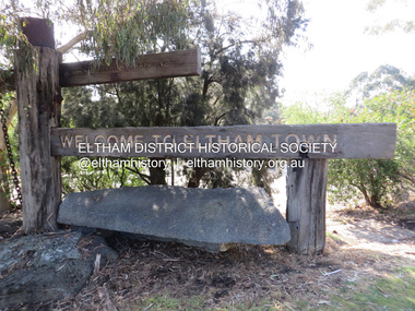
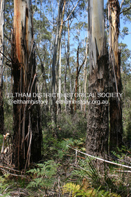
 Eltham District Historical Society Inc
Photograph, Fay Bridge, EDHS Heritage Walk: Shillinglaw Farm, Eltham, 2 September 2023
... Commencing at the corner of Panther Place and Library Place, we proceeded up to Shillinglaw Cafe then the Shillinglaw trees at the former Eltham Shire Office site then along Main Road to the fire station then throughh St Laurence Lane and uinder the railway line , along Diamond Street then return via the Diamond Creek trail behind Andrew Park. ...Commencing at the corner of Panther Place and Library Place, we proceeded up to Shillinglaw Cafe then the Shillinglaw trees at the former Eltham Shire Office site then along Main Road to the fire station then throughh St Laurence Lane and uinder the railway line , along Diamond Street then return via the Diamond Creek trail behind Andrew Park. ...On Saturday September 2, 2023, Russell Yeoman led a group of 22 society members and interested others on a walk following trhe bounadries of the original Shillingalw farm. Commencing at the corner of Panther Place and Library Place, we proceeded up to Shillinglaw Cafe then the Shillinglaw trees at the former Eltham Shire Office site then along Main Road to the fire station then throughh St Laurence Lane and uinder the railway line , along Diamond Street then return via the Diamond Creek trail behind Andrew Park. The actual farm boundary went past the creek and further up the hill. The original farm comprised lot 90 of Holloway’s 1851 subdivision of Little Eltham. Its area was 30 acres lying east of the Diamond Creek and north of Henry Street. A number of stops were made to look at maps and early photos illustrating the gradual reduction of the farm area and the early history of the railway and other community uses, that occupied parts of the site.fay bridge collection, 2023-09-02, activities, eltham, eltham district historical society, heritage excursion, shillinglaw farm -
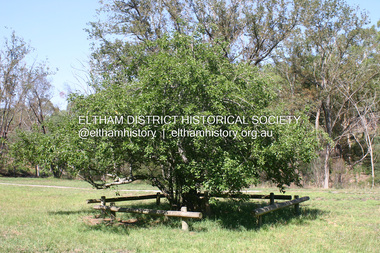
 Eltham District Historical Society Inc
Photograph, Liz Pidgeon, EDHS Heritage Walk: Shillinglaw Farm, Eltham, 2 September 2023
... Commencing at the corner of Panther Place and Library Place, we proceeded up to Shillinglaw Cafe then the Shillinglaw trees at the former Eltham Shire Office site then along Main Road to the fire station then throughh St Laurence Lane and uinder the railway line , along Diamond Street then return via the Diamond Creek trail behind Andrew Park. ...Commencing at the corner of Panther Place and Library Place, we proceeded up to Shillinglaw Cafe then the Shillinglaw trees at the former Eltham Shire Office site then along Main Road to the fire station then throughh St Laurence Lane and uinder the railway line , along Diamond Street then return via the Diamond Creek trail behind Andrew Park. ...On Saturday September 2, 2023, Russell Yeoman led a group of 22 society members and interested others on a walk following trhe bounadries of the original Shillingalw farm. Commencing at the corner of Panther Place and Library Place, we proceeded up to Shillinglaw Cafe then the Shillinglaw trees at the former Eltham Shire Office site then along Main Road to the fire station then throughh St Laurence Lane and uinder the railway line , along Diamond Street then return via the Diamond Creek trail behind Andrew Park. The actual farm boundary went past the creek and further up the hill. The original farm comprised lot 90 of Holloway’s 1851 subdivision of Little Eltham. Its area was 30 acres lying east of the Diamond Creek and north of Henry Street. A number of stops were made to look at maps and early photos illustrating the gradual reduction of the farm area and the early history of the railway and other community uses, that occupied parts of the site.2023-09-02, activities, eltham, eltham district historical society, heritage excursion, shillinglaw farm, 895 main road, amplifon, andrew park, andrew pocket park, arthur street, bar de tapas, barber shop, barry plant estate agent, blockbuster, bus depot, car park, carparks, central park, cleaver & co hair, commonwealth bank, crust pizza, divine bridal, dr ash constance, dudley street, eltham book shop, eltham convenience store, eltham fire station, eltham library, eltham newsagency, eltham optical, eltham railway station, eltham shops, fay bridge, fire bell, flagpole, flight centre, grill'd, information sign, iso chook, jellis craig estate agent, judge book village, kebab nation, kx pilates, la zanyas, liquorland, little drop of poison, lorraine jones & associates solicitors, luck street, machan indian restaurant, main road, mecho en mexico, missing gorilla, morrison kleeman real estate, pavilion menswear, platform 3095, playtherapy melbourne, pryor street, ray white real estate, restaurants, sage bulk whole foods, shillinglaw trees, sign, snap fitness, southern cross medical imaging, specsavers, st laurence lane, st vincents care service, thompson's pharmacy, todaro, united service station, vyve body & skin, welcome to eltham town, westpac bank, yang's kitchen, youth road -
 Eltham District Historical Society Inc
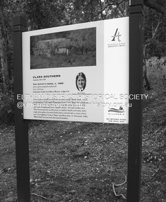
Photograph - Digital Photograph, Alan King, Sign: Clara Southern, Heidelberg School Artists Trail, Main Road, Research, 2008
... fires. It includes photographs taken especially for the publication, creating a unique time capsule representing the Shire in the early 21st century. It remains the most recent comprehenesive publication devoted to the Shire's history connecting local residents to the past. Nillumbik Now and Then (Marshall-King) Collection Clara Southern Main Road Research (Vic) Heidelberg School Artists Trail ...Warrandyte artist, Clara Southern, features on the Artists Trail. Published: Nillumbik Now and Then / Marguerite Marshall 2008; photographs Alan King with Marguerite Marshall.; p189 Since early in the 20th century this district has attracted artists and other creative people. So much so, that Eltham has been compared to the Left Bank in Paris, New York’s Greenwich Village and London’s Bloomsbury. That is until the 1970s when Eltham rapidly expanded into a suburb. However many artists still flourish not only in Montsalvat, Dunmoochin and the Bend of Islands but elsewhere in Nillumbik. Some artists who have worked or lived in Nillumbik are well-known nationally and internationally. Artists are attracted to the hilly district’s subtle colours, unique light and the Yarra River and Diamond Creek. The railway’s extension to Eltham in 1902 brought artists to paint for the day or to camp. Then many settled in Eltham, perhaps also because the poor quality land, far from the city, was cheap. Following World War Two they found they could build houses and studios cheaply by making their own mud-bricks. The flexible material, with its warm tones blending into the bush, also satisfied their aesthetic sensibilities. As early as 1900, Will Longstaff, known for his painting The Ghosts of Menin Gate at the National War Memorial in Canberra, lived at Stanhope in Peter Street, Eltham, later to become the home of intellectuals Clem and Nina Christensen. Members of Australia’s first significant art movement, the Heidelberg School of Artists, painted in Eltham, Warrandyte and Diamond Creek. Walter Withers lived at the corner of Bolton and Brougham Street, Eltham and taught Sir Hans Heysen, who for a short while stayed with the Withers family. In Warrandyte were Clara Southern, whom Frederick McCubbin taught at the National Gallery School and Penleigh Boyd, who is represented in all Australian state galleries and the National Collection in Canberra. May Vale, daughter of politician William, lived in Diamond Creek. With Jane Price they feature on the Heidelberg School Artists Trail, part of which runs through Nillumbik. The trail includes signs each displaying a reproduction of a painting by an artist and located near where the artist lived or painted. In Nillumbik the trail includes parts of Warrandyte, Eltham in the Alistair Knox Park, Main Road shopping precinct and Wingrove Park, the Research walking track on Main Road and the Diamond Creek Reserve. In 1916 artist William ‘Jock’ Frater lived at the corner of Arthur and Bible Streets, Eltham. Before then, Frater, with other artists including Percy Leason (who moved to Eltham in the mid 1920s) painted in Eltham on weekends. They camped near Bible and Pitt Streets and along the Diamond Creek where the Eltham Retirement Centre now stands.4 In 1921, painter Peter Newbury (father to painter David Newbury, who was born in Eltham) moved to Cromwell Street, Eltham. Max Meldrum, the first Australian painter to formulate a consistent theory of art largely based on tone,5 taught local artists Alan Martin, Clarice Beckett, Peter Glass and Justus Jörgensen. Meldrum visited Eltham then rented a house there for 18 months opposite Wingrove Park. In 1934, artist and architect Justus Jörgensen and his doctor wife Lil and friends built Montsalvat, the artists’ colony. Montsalvat has played an important part in attracting artists to Eltham and its mud-brick, pisé, stone and recycled building materials has had a major influence on Eltham’s built environment. Jörgensen’s students who also helped him build Monstalvat included Arthur Munday, Lesley Sinclair, Helen Lempriere, Joe Hannan, Helen, Sonia and jeweller/sculptor, Matcham Skipper. Among artists who visited Montsalvat were Clifton Pugh and Angry Penguins’ artists Albert Tucker and Arthur Boyd. Some who painted after World War Two were Alan Martin of Eltham and Warrandyte artists Frank Crozier and Harry De Hartog6, one of Melbourne’s first painters influenced by Cubism.This collection of almost 130 photos about places and people within the Shire of Nillumbik, an urban and rural municipality in Melbourne's north, contributes to an understanding of the history of the Shire. Published in 2008 immediately prior to the Black Saturday bushfires of February 7, 2009, it documents sites that were impacted, and in some cases destroyed by the fires. It includes photographs taken especially for the publication, creating a unique time capsule representing the Shire in the early 21st century. It remains the most recent comprehenesive publication devoted to the Shire's history connecting local residents to the past. nillumbik now and then (marshall-king) collection, clara southern, main road, research (vic), heidelberg school artists trail -
 Eltham District Historical Society Inc
Photograph - Digital Photograph, Alan King, Heritage apple tree, 24 January 2008
... fires. It includes photographs taken especially for the publication, creating a unique time capsule representing the Shire in the early 21st century. It remains the most recent comprehenesive publication devoted to the Shire's history connecting local residents to the past. Nillumbik Now and Then (Marshall-King) Collection Greensborough John Batman Tree Plenty River Trail ...This old apple tree situated beside the Plenty River Trail at Greensborough has been associated with Melbourne Founder John Batman. The concrete block is inscribed with the date 1841, when the tree was thought to have been planted. Known as Batman's Tree, this apple tree is on the bank of the Plenty River near Leischa Court, Greensborough. It is said that Melbourne Founder John Batman may have planted the tree and later signed his treaty here with the Aboriginal people. It still bears fruit and its recorded on the National Trust's Register of Significant Trees, as the oldest apple tree in Victoria. Published: Nillumbik Now and Then / Marguerite Marshall 2008; photographs Alan King with Marguerite Marshall.; p7This collection of almost 130 photos about places and people within the Shire of Nillumbik, an urban and rural municipality in Melbourne's north, contributes to an understanding of the history of the Shire. Published in 2008 immediately prior to the Black Saturday bushfires of February 7, 2009, it documents sites that were impacted, and in some cases destroyed by the fires. It includes photographs taken especially for the publication, creating a unique time capsule representing the Shire in the early 21st century. It remains the most recent comprehenesive publication devoted to the Shire's history connecting local residents to the past. nillumbik now and then (marshall-king) collection, greensborough, john batman tree, plenty river trail -
 Eltham District Historical Society Inc
Photograph - Digital Photograph, Marguerite Marshall, Eltham Lower Park, 20 April 2008
... Trail. This collection of almost 130 photos about places and people within the Shire of Nillumbik, an urban and rural municipality in Melbourne's north, contributes to an understanding of the history of the Shire. Published in 2008 immediately prior to the Black Saturday bushfires of February 7, 2009, it documents sites that were impacted, and in some cases destroyed by the fires. ...Originally a race course, the park has brought the community together with a variety of activities. Published: Nillumbik Now and Then / Marguerite Marshall 2008; photographs Alan King with Marguerite Marshall.; p45 Once used for horse racing, which attracted visitors from Melbourne, the Eltham Lower Park has brought the community together with a wide range of activities. Horse riding is now enjoyed as a recreation in the park as are other sports. The park also includes the Diamond Valley Railway miniature trains and a sanctuary for the rare and vulnerable Eltham Copper Butterfly. Eltham Lower Park, with other parks, forms an almost continuous green band from Eltham’s centre, along the Diamond Creek to the Yarra River.1 Before European settlement the Wurundjeri people met on this land, particularly at the junction of the Diamond Creek with the Yarra River, which they called Birr-arung. This is commemorated by the sculpture, Not just a Pretty Place by Aleks Danko, winner of the 2000 Nillumbik Art in Public Places Award. The first European to settle here was probably Henry Foley, who in 1841 used it as part of his pastoral run. Foley sold his leasehold to Joseph Wilson in 1845, who soon after sold it to Frederick Falkiner. During the 1840s the future park was part of a government square mile (2.6 sqkm) reserve, north of the Yarra, within the Parish of Nillumbik, later named Eltham. Soon the land was used for horse racing after nearby residents cleared ten acres (4ha) in the early 1850s. A three-quarter of a mile (1.2km) race secured the winner the £10 Publican’s Prize. In response to popular demand, the newly formed Eltham District Road Board petitioned the Surveyor General of the Colony of Victoria, in 1856, for 36 acres (14.6ha) of crown land for a racecourse and recreation. By 1858 the Eltham races had become an institution. ‘Many skirmishes occurred and the way home was paved with temptation, with sly-grog for sale.3 In the early 1870s, two jockeys were sons of the police officer in charge of the Eltham Police Station, Miles S Lyons. Another ten acres (4ha) was added to the area in 1866 and 12 acres (4.8ha) – Hohnes Hill – in 1870. In 1866, two acres (0.8ha) on the creek banks became an animal pound with William Walsh the pound keeper in 1870, but this was later incorporated into the park. By 1877 the area was called a public park but horse racing and training continued into the 1920s. In the mid-1900s trotters were trained on a circuit road. In 1953 the Eltham Pony Club was established and used a cross-country course on Hohnes Hill. From the mid 1950s the club held the Eltham Easter Fair at the park, later to include a procession along Main Road from the town centre to the park. The park also attracted picnic parties and campers from the inner suburbs as did Wingrove Park, and businesses catering for visitors, sprang up on the opposite side of Main Road. Bus-loads of school children visited the park for Gould League bird days in the 1960s. In 1979 the Eltham Shire Council bought Lenister Farm, linking the park with the Yarra River. The Lenister Farm wetland includes a bird hide, viewing platform and interpretive signs.5 Pioneer Henry Stooke, later Road Board chairman, bought the 11 acres (4.5ha) - later to become Lenister Farm - from the Crown in 1862. Stooke never lived on this site and the two houses at Lenister Farm were built in the 20th century. Since its formation in 1871, the Council has controlled this crown land, which it named Eltham Park. But in the 1920s Eltham Council bought land near the town centre for a park, which it named Eltham Central Park. To avoid confusion the Council renamed Eltham Park, Eltham Lower Park. Since 2004 the Yarra footbridge has linked the park with the Yarra Valley Metropolitan Park and the Main Yarra Trail.This collection of almost 130 photos about places and people within the Shire of Nillumbik, an urban and rural municipality in Melbourne's north, contributes to an understanding of the history of the Shire. Published in 2008 immediately prior to the Black Saturday bushfires of February 7, 2009, it documents sites that were impacted, and in some cases destroyed by the fires. It includes photographs taken especially for the publication, creating a unique time capsule representing the Shire in the early 21st century. It remains the most recent comprehenesive publication devoted to the Shire's history connecting local residents to the past. nillumbik now and then (marshall-king) collection, eltham lower park, eltham park -
Eltham District Historical Society Inc
Document - Folder, Lex de Man
... Newspaper artivle: "Blazing recovery trail", Diamond Valley Leader, 26 January 2011, Lex de Man awarded an Australian fire Service Medal in the 2011 Australia Day Awards; details of. his career and his comments on CFA volunteers....Newspaper artivle: "Blazing recovery trail", Diamond Valley Leader, 26 January 2011, Lex de Man awarded an Australian fire Service Medal in the 2011 Australia Day Awards; details of. his career and his comments on CFA volunteers. ...Lex de Man, manager of Country Fire Association region 14, became Mayor of Nillumbik in 2002, four years after he and fellow councillors were sacked by the Kennett government. In the 2009 Black Saturday fires, he led eastern metropolitan CFA volunteers and was awarded an Australian Fire Service Medal as part of the 2011 Australia Day Awards. He was a CFA volunteer for more than 30 years, a CFA employee for 15 years, and had served with Victoria Police for 18 years. He is a member of the Yarrambat Historical Society, Yarrambat CFA and the Greensborough Hockey Club. He lives at Yarrambat. Contents Newspaper article: "Voters wield axe on greens", Diamond Valley Leader, 27 March 2002, Report of Nillumbik Council election 16 March, which Diamond Creek solicitor Tony Raunic survived (beating Margaret Jennings) but all five pro-Green Wedge councillors lost. Others elected included Greg Johnson, Natalie Woodley, Belinda Clarkson, Mike Irwin, Lionel Draper, Bob Stubbings, Michael Hall and Lex de Man. Those beaten included Bill Penrose, Sigmund Jorgensen, Di Bullen and Penny Mullinar. Newspaper article: "The Man for the job", diamond Valley Leader, 3 April 2002, Report of Nillumbik Council swearing-in, details about Lex de Man, and Nillumbik Council meeting including Greg Johnson's speech. Newspaper artivle: "Blazing recovery trail", Diamond Valley Leader, 26 January 2011, Lex de Man awarded an Australian fire Service Medal in the 2011 Australia Day Awards; details of. his career and his comments on CFA volunteers.Newspaper clippings, A4 photocopies, etcmernda victoria, black saturday fires 2009, les de man, country fire authority victoria, victoria police, tony raunic, margaret jennings, green wedge nillumbik, greg johnson, natalie woodley, belinda clarkson, mike irwin, lionel draper, bob stubbings, michael hall, bill penrose, sigmuynd jorgensen, di bullen, penny mullinar -
 Eltham District Historical Society Inc
Photograph - Digital Photograph, Alan King, Manna Gums at the Gawa Wurundjeri Aboriginal Resource Trail, 28 December 2007
... trail introduces visitors to the indigenous flora and fauna, including manna gums, Lomandra (used to weave baskets) and wombat burrows. Published: Nillumbik Now and Then / Marguerite Marshall 2008; photographs Alan King with Marguerite Marshall.; p3 This collection of almost 130 photos about places and people within the Shire of Nillumbik, an urban and rural municipality in Melbourne's north, contributes to an understanding of the history of the Shire. Published in 2008 immediately prior to the Black Saturday bushfires of February 7, 2009, it documents sites that were impacted, and in some cases destroyed by the fires ...Manna Gum is a species of a small to a very tall tree that is endemic to south-eastern Australia. These particular trees are part of the Gawa Wurundjeri Resource Trail at Watsons Creek. Signs share information about how the Wurundjeri people lived near the creek and used the land to obtain bush foods, medicines, tools, shelter and clothes. The trail introduces visitors to the indigenous flora and fauna, including manna gums, Lomandra (used to weave baskets) and wombat burrows. Published: Nillumbik Now and Then / Marguerite Marshall 2008; photographs Alan King with Marguerite Marshall.; p3This collection of almost 130 photos about places and people within the Shire of Nillumbik, an urban and rural municipality in Melbourne's north, contributes to an understanding of the history of the Shire. Published in 2008 immediately prior to the Black Saturday bushfires of February 7, 2009, it documents sites that were impacted, and in some cases destroyed by the fires. It includes photographs taken especially for the publication, creating a unique time capsule representing the Shire in the early 21st century. It remains the most recent comprehenesive publication devoted to the Shire's history connecting local residents to the past. nillumbik now and then (marshall-king) collection, gawa wurundjeri aboriginal resource trail, manna gums, watsons creek -
 Eltham District Historical Society Inc
Photograph - Digital Photograph, Alan King, Heritage apple tree, 24 January 2008
... fires. It includes photographs taken especially for the publication, creating a unique time capsule representing the Shire in the early 21st century. It remains the most recent comprehenesive publication devoted to the Shire's history connecting local residents to the past. Nillumbik Now and Then (Marshall-King) Collection Greensborough John Batman Tree Plenty River Trail ...This old apple tree situated beside the Plenty River Trail at Greensborough has been associated with Melbourne Founder John Batman. Known as Batman's Tree, this apple tree is on the bank of the Plenty River near Leischa Court, Greensborough. It is said that Melbourne Founder John Batman may have planted the tree and later signed his treaty here with the Aboriginal people. It still bears fruit and its recorded on the National Trust's Register of Significant Trees, as the oldest apple tree in Victoria. Published: Nillumbik Now and Then / Marguerite Marshall 2008; photographs Alan King with Marguerite Marshall.; p7 Was This John Batman's Tree? An apple tree on the bank of the Plenty River near Leischa Court, Greensborough, is believed to have belonged to Melbourne’s founder, John Batman. It could also stand where John Batman signed his famous treaty with the Aboriginal people.1 Known as Batman’s Tree, it still bears fruit and is recorded on the National Trust’s Register of Significant Trees, as the oldest apple tree in Victoria. It is ‘Believed to have been planted by either John Batman, (c1837) or Martin Batey (1841)’.2 In 1966 a Horticultural Adviser, Mr Rolfe, after extensive questioning of aged Greensborough residents, wrote: ‘it thus seems fairly certain that the old tree on the banks of the Plenty River is an original Batman apple tree’. Mr Rolfe said that the tree stood on a spot formerly called Wattle Bend: ‘one of the sites claimed to be where John Batman signed his famous treaty with the aboriginals. ‘My main source of information has been interviews with people who attended school in the Greensborough area from 70 to 80 years ago. Their parents were close to the days when Melbourne was founded so information passed on by word of mouth.’ Around 1920 the tree was struck by lightning and a concrete block was placed in the split. The concrete is inscribed with the date 1841 when the tree was thought to have been planted. Not everyone agrees with Mr Rolfe however. Former secretary of the Nillumbik Historical Society, Kevin Patterson, said there was no written evidence to support the claim. But he said the tree had been known to locals for decades as Batman’s Tree. In the 1920s a holiday resort in the area advertised: ‘Come to Greensborough and see John Batman’s tree’. Mr Patterson said it was thought that when Batman died in 1839 his land was sold and a Greensborough man Frederick Flintoff bought seedlings from his orchard for £1 each. This was the only one left.3 Mr Rolfe said: ‘If planted in 1837, or even a few years later, it undoubtedly is the oldest living apple tree in Victoria. Title records of the property on which the tree grows show that the land was a crown grant of F D Wickham in 1840. Mr Wickham was reputed to be a friend of John Batman. All the early settlers prior to the crown grants were squatters, by virtue of Batman’s treaty. This treaty was revoked by the then New South Wales Government, so it is likely that Wickham or an agent was in occupation before 1840. ‘According to Mrs Mavis Latham (John Batman – Great Australian Series, Oxford University Press) when Batman came to Port Phillip in 1835 he brought fruit trees with him. He failed to get a crown grant for his selection on Collins Street, which included 20 acres (eight ha) of orchard and cultivation. His residence became the Government Office and Melbourne grew from wild bushland in 1835 to a town of over 20,000 people by 1841. It is possible Batman visited Wickham and presented him with a tree.’ However a Flintoff descendant in 1933 said Frederick Flintoff ordered his bailiff Martin Batey to transplant the Batman Tree from the Spencer Street orchard to its present site as a memorial to his friend Batman.4 Mr Rolfe spoke to many people, including descendants of the Bateys and Flintoffs and pupils at the Greensborough Primary School. Many had gained their information from a ‘very highly respected’ head master Lewis Amiet at the Greensborough School from 1895 to 1917. He must have gained this information from residents in the district and had this information been incorrect, the parents of the children would have promptly corrected him.’ One woman who attended the school before Mr Amiet’s appointment, said the previous teacher also taught that the tree on the Plenty River was a Batman tree, Mr Rolfe said.This collection of almost 130 photos about places and people within the Shire of Nillumbik, an urban and rural municipality in Melbourne's north, contributes to an understanding of the history of the Shire. Published in 2008 immediately prior to the Black Saturday bushfires of February 7, 2009, it documents sites that were impacted, and in some cases destroyed by the fires. It includes photographs taken especially for the publication, creating a unique time capsule representing the Shire in the early 21st century. It remains the most recent comprehenesive publication devoted to the Shire's history connecting local residents to the past. nillumbik now and then (marshall-king) collection, greensborough, john batman tree, plenty river trail -
 Greensborough Historical Society
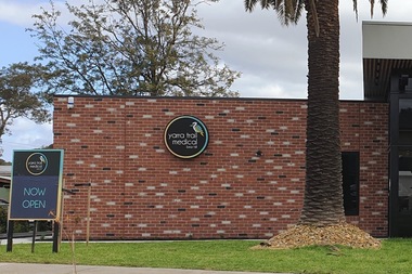
Photograph - Photograph - Digital Image, Marilyn Smith, Yarra Trail Medical 113 Mountainview Road Montmorency, 04/09/2021
... Digital image of Yarra Trail Medical 113 Mountainview Road Montmorency. This medical centre was purpose built following a fire at this address....Greensborough Historical Society 34A Glenauburn Road Lower Plenty Lower Plenty melbourne Digital image of Yarra Trail Medical 113 Mountainview Road Montmorency. This medical centre was purpose built following a fire at this address. ...Digital image of Yarra Trail Medical 113 Mountainview Road Montmorency. This medical centre was purpose built following a fire at this address.Part of a collection of miscellaneous historical images with a connection to the local area.Digital colour photograph. yarra trail medical, mountainview road briar hill, medical centres -
 Running Rabbits Military Museum operated by the Upwey Belgrave RSL Sub Branch
Ikara Missile, Maribyrnong Ordinance Factory in Victoria. et al, 1965
... fire control system. The IKARA is an unmanned miniature aircraft with clip on upper and lower stabilizers and wings. The upper stabilizer (SVU) housed and electronic package that transmitted flight data back to the launch platform and received updated target acquisition data during flight. Flight maneuverability was provided by elevons fitted into the trailing...fire control system. The IKARA is an unmanned miniature aircraft with clip on upper and lower stabilizers and wings. The upper stabilizer (SVU) housed and electronic package that transmitted flight data back to the launch platform and received updated target acquisition data during flight. Flight maneuverability was provided by elevons fitted into the trailing ...During the 1950’s, the growing threat from Submarines, led the Royal Australian Navy to consider a quick reaction, long range ASW torpedo delivery system as an alternative to the USN’s ASROC and the RN’s Match. Full scale research and development began in 1960 using the Turana target drone as the basis for the delivery platform. Shipboard tests began in 1963 and the Government Aircraft Factory (GAF) began production of three variants M3, M4 and M5 in 1965. The M4 variant had a guidance system designed to interface to a full tactical data handling system while the M3 and M5 variants used a simpler system with a dedicated fire control system. The IKARA is an unmanned miniature aircraft with clip on upper and lower stabilizers and wings. The upper stabilizer (SVU) housed and electronic package that transmitted flight data back to the launch platform and received updated target acquisition data during flight. Flight maneuverability was provided by elevons fitted into the trailing edge of each wing, these were operated by an actuator system that received flight correction data transmitted to the autopilot from the fire control system. The payload, either the Mk44 or Mk46 lightweight torpedo was suspended to the underside of the airframe and faired into the body to provide and aerodynamic shape. The forward section of the body housed the autopilot and the thermal battery unit. Propulsion was provided by the MURAWA steel cased, solid propellant rocket motor with a combined boost and sustainer stage. IKARA was capable of engaging a target to the maximum range of the ships sonar, regardless of weather conditions. Target information is fed into the fire control system, which calculated to drop zone for the torpedo taking into account speed and direction of launch platform and target, win speed etc, then tracking the missile to the drop zone where command signals initiate torpedo release. The IKARA is an unmanned miniature aircraft with clip on upper and lower stabilizers and wings. navy, torpedo, rocket, submarine, missile -
 Bendigo Historical Society Inc.
Slide - Peter Ellis Collection, Kaweka Wildflower Reserve, Castlemaine, Lightning Hill Lookout Bendigo, One Tree Hill Lookout Tower Bendigo, Kamarooka Forest Area, c1970-1972
... trail bird watch have a picnic at the picnic tables. RUSH Dam is a basic free camping area sits alongside Rush Dam in the Greater Bendigo National Park, featuring a single picnic table and wood fire barbecue....trail bird watch have a picnic at the picnic tables. RUSH Dam is a basic free camping area sits alongside Rush Dam in the Greater Bendigo National Park, featuring a single picnic table and wood fire barbecue. history bendigo peter ellis collection whipstick bendigo Bendigo State Forests kaweka wildflower reserve castlemaine one tree hill lookout bendigo lightning hill lookout bendigo kamarooka rush dam kamarooka Greater Bendigo National Park Peter Ellis Collection: Seventeen slides of Kaweka Wildflower Reserve, Castlemaine, Lightning Hill Lookout Bendigo, One Tree Hill Lookout Tower Bendigo. ...Kaweka Reserve is a a small reserve of approximately 8ha. The land was donated to the Castlemaine City to be a wildflower Reserve. A management committee was formed in 1966. The committee is still managing the park. Vicroads Edition 6: Map 59E2, 628 H4 Location. Turner St, Castlemaine. From the Castlemaine Post Office, drive north (towards Bendigo) and turn right along Turner Street to the park entrance. What to do: walk along some of the tracks through the park follow the nature trail bird watch have a picnic at the picnic tables. RUSH Dam is a basic free camping area sits alongside Rush Dam in the Greater Bendigo National Park, featuring a single picnic table and wood fire barbecue.Peter Ellis Collection: Seventeen slides of Kaweka Wildflower Reserve, Castlemaine, Lightning Hill Lookout Bendigo, One Tree Hill Lookout Tower Bendigo. Also the Rush Dam free camping area at Kamarooka. Also a slide of an unknown group having a meal or day out; perhaps also a working bee. In addition there are two slides of a house - location not specified; and a working bee clearing along a pipeline at Big Hill. Peter was a chemistry lecturer at the Bendigo Institute of technology.history, bendigo, peter ellis collection, whipstick bendigo, bendigo state forests, kaweka wildflower reserve castlemaine, one tree hill lookout bendigo, lightning hill lookout bendigo, kamarooka, rush dam kamarooka, greater bendigo national park -
 Flagstaff Hill Maritime Museum and Village
Ceramic - Roof Tile, Circa 1914
... firing off shells and rockets, but his story was passed off as a joke. These rockets were most likely the distress signals from the stricken ship. The Italian barque/clipper Antares was sometime later reported as overdue. The wreck of the ship was later found at the base of a cliff at the Bay of Islands near Warrnambool in November 1914, there were no survivors. The Antares is significant as it was a sail trader carrying an international inbound cargo during the early part of the 20th century. It is part of the Great Ocean Road Historic Shipwreck Trail ...The Italian barque Antares was an iron three-masted sailing clipper built in 1888 by Russell & Co of Port Glasgow originally named the “Sutlej” and renamed in 1907 the “Antares” when sold to the Semider Bros of Genoa Italy. The vessel left Marseilles on the 18th of December 1913 with its master captain Gazedo destined for Mullaly & Byrne of Melbourne with a cargo of roof tiles but failed to arrive. The wreckage was found near the Bay of Islands twenty-two miles east of Warrnambool after a body had washed ashore. Some of the timbers washed up were charred by fire, and a small boat's stern board with the name "Sutlej" led to the identification of the wreck as Antares which had been reported missing. According to later reports, the Antares wrecking was overshadowed by war news at the time. A young local boy had remarked that the Germans had arrived off the coast as he had seen them firing off shells and rockets, but his story was passed off as a joke. These rockets were most likely the distress signals from the stricken ship. The Italian barque/clipper Antares was sometime later reported as overdue. The wreck of the ship was later found at the base of a cliff at the Bay of Islands near Warrnambool in November 1914, there were no survivors.The Antares is significant as it was a sail trader carrying an international inbound cargo during the early part of the 20th century. It is part of the Great Ocean Road Historic Shipwreck Trail and as such is registered as a protected wreck in the Victorian Heritage Database VHS S34 .Roof tile; clay terracotta roof tile. Inscriptions are impressed into the clay. It was recovered from the wreck of the Antares. ”- E R I E S DE LA MEDITERRANEE” “ … T S – MI-LES BOU- R …..” SYMBOL [Sideways crown or tree (could be TULLERIES DE LA MEDITERRANEE)]flagstaff hill, warrnambool, flagstaff hill maritime museum, maritime museum, shipwreck coast, flagstaff hill maritime village, great ocean road, roofing tile, building materials, antares, peterborough, 1914 shipwreck, sutlej, antares rock., bay of islands, terracotta tile, clipper -
 Flagstaff Hill Maritime Museum and Village
Functional object - Porthole Frame, Russell & Co, 1888
... firing off shells and rockets, but his story was passed off as a joke. These rockets were most likely the distress signals from the stricken ship. The Italian barque, clipper, Antares was sometime later reported as overdue. The wreck of the ship was later found at the base of a cliff at the Bay of Islands near Warrnambool in November 1914; there were no survivors. The Antares is significant as it was a sail trader carrying international inbound cargo during the early part of the 20th century. It is part of the Great Ocean Road Historic Shipwreck Trail ...This portion of the porthole frame was part of the fittings of the Antares. The Italian barque “Antares” was an iron three-masted sailing ship built in 1888 by Russell & Co of Port Glasgow. The ship was originally named the “Sutlej” but was renamed the “Antares” in 1907 when sold to the Semider Bros of Genoa, Italy, where it was registered. The vessel left Marseilles on the 18th of December 1913 with its master Captain Gazedo destined for Mullaly & Byrne of Melbourne with a cargo of roofing tiles but failed to arrive. The wreckage was found near the Bay of Islands, twenty-two miles east of Warrnambool, after a body had washed ashore. Some of the timbers washed up were charred by fire, and a small boat's stern board with the name "Sutlej" led to the identification of the wreck as Antares, which had been reported missing. According to later reports, the Antares wrecking was overshadowed by war news at the time. A young local boy had remarked that the Germans had arrived off the coast as he had seen them firing off shells and rockets, but his story was passed off as a joke. These rockets were most likely the distress signals from the stricken ship. The Italian barque, clipper, Antares was sometime later reported as overdue. The wreck of the ship was later found at the base of a cliff at the Bay of Islands near Warrnambool in November 1914; there were no survivors.The Antares is significant as it was a sail trader carrying international inbound cargo during the early part of the 20th century. It is part of the Great Ocean Road Historic Shipwreck Trail and as such is registered as a protected wreck in the Victorian Heritage Database VHS S34 .Porthole frame section, brass, large part corroded away. Hing is still visible on the end. The underside is shaped to allow the fitting of the glass. Recovered from the wreck of the Antares. Noneflagstaff hill, warrnambool, shipwrecked-coast, flagstaff-hill, flagstaff-hill-maritime-museum, maritime-museum, shipwreck-coast, flagstaff-hill-maritime-village, antares, tall ship, sailing ship, peterborough, phillip le couteur, peter mathieson, constable stainsbury, sutlej, antares rock., bay of islands, porthole, ship fitting, 1914 shipwreck, porthole frame -
 National Vietnam Veterans Museum (NVVM)
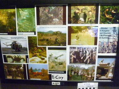
Photograph - Collage 9RAR B Coy
... Trail...Tet Offensive...Collage...Photograph...B Coy...9 RAR...Operation Goodwood...L/Cpl Alan Eliot Chandler...218518...Royal Australian Infantry Corps...9th Battalion...The Royal Australian Regiment...Pte Brian Hamilton...2788717...Australian National Serviceman...Cpl Dennis James Cole...217820...Sioux (helicopter)...Sanford AAF...Pte Bernd George Fritz Binder...134994...Killed in Action...Pte Stuart John Kaighin...3793272...L/Cpl Donald William McPherson...39505...Fire...National Vietnam Veterans Museum (NVVM) 25 Veterans Drive Newhaven phillip-island-and-the-bass-coast FSPB Maria Operation Firestone Trail Tet Offensive Collage Photograph B Coy 9 RAR Operation Goodwood L/Cpl Alan Eliot Chandler 218518 Royal Australian Infantry Corps 9th Battalion The Royal Australian Regiment Pte Brian Hamilton 2788717 Australian National Serviceman Cpl Dennis James Cole 217820 Sioux (helicopter) Sanford AAF Pte Bernd George Fritz Binder 134994 Killed in Action Pte Stuart John Kaighin 3793272 L/Cpl Donald William McPherson 39505 Fire Support Base Maria Operation Reynella Pte Geoffrey Andrew Holman 4720135 Pte Jeffrey Walter Meilland 1734640 L/Cpl James Ian Muir 217603 Operation Jack Maj Edward Albert Chitham 235140 Military Cross Commanding Officer Cpl (Temp) Peter (Bluey) John Millett 423360 WO2 Kevin Stanley Grills 231268 Cpl (Temp) Ivor Alexander 3175429 B Coy Seventeen colour Photograph "B Coy" 9 RAR in black frame. depicting Ptes Rogers, Muir, Dorward, Holman, Hamilton, Cole, Chandler, Binder, Kaighin, Durick, McPherson, Meilland, Millet. ...Seventeen colour Photograph "B Coy" 9 RAR in black frame. depicting Ptes Rogers, Muir, Dorward, Holman, Hamilton, Cole, Chandler, Binder, Kaighin, Durick, McPherson, Meilland, Millet. WO Grills. CO Chitham.B Coyfspb maria, operation firestone trail, tet offensive, collage, photograph, b coy, 9 rar, operation goodwood, l/cpl alan eliot chandler, 218518, royal australian infantry corps, 9th battalion, the royal australian regiment, pte brian hamilton, 2788717, australian national serviceman, cpl dennis james cole, 217820, sioux (helicopter), sanford aaf, pte bernd george fritz binder, 134994, killed in action, pte stuart john kaighin, 3793272, l/cpl donald william mcpherson, 39505, fire support base maria, operation reynella, pte geoffrey andrew holman, 4720135, pte jeffrey walter meilland, 1734640, l/cpl james ian muir, 217603, operation jack, maj edward albert chitham, 235140, military cross, commanding officer, cpl (temp) peter (bluey) john millett, 423360, wo2 kevin stanley grills, 231268, cpl (temp) ivor alexander, 3175429 -
Marysville & District Historical Society
THE TRIANGLE NEWS-VOL 41 NO 5-FEBRUARY 14 2014
... marysville victoria australia marysville & district lions club skate park/bmx/basketball practice area complete what's on when in february marysville p.s. parents club agm marysville op shop agm marysville sub branch rsl agm men's shed the committee of management of the gallipoli park precinct creative triangle marysville community market fishing competition family picnic and fun day buxton ridge vineyard wine tasting church notices the annual motorhome event at buxton looking for helpers highwood health mayor's chair planning and environment act 1987 adventurous cooks black spur caravan park t20 cricket comes to marysville advertisements payment of rate instalment murrindindi shire council marysville real estate fallons bus service alexandra marysville route service position vacant parks & gardens officer marysville branch liberal party agm valentine's day 3 course dinner black spur inn heartfelt thoughts mark anniversary murrindindi shire council kinglake office buxton hall show councillor comment irish band saoirse el kanah marysville culture community frog trail hopping along despite fungus foe department of environment & primary industries promote your community group on line opening of upper room restaurant regional information for 8 & 9 feb valentine's day maryton park made in marysville grand opening compensation bid 2009 black saturday fires scarecrow competition marysville region really long lunch buxton progress assocn rock 'n roll night at buxton hall murrindindi shire council welcomes new citizens world's greatest shave THE TRIANGLE NEWS-VOL 41 NO 5-FEBRUARY 14 2014 ...marysville, victoria, australia, marysville & district lions club, skate park/bmx/basketball practice area complete, what's on when in february, marysville p.s. parents club agm, marysville op shop agm, marysville sub branch rsl agm, men's shed, the committee of management of the gallipoli park precinct, creative triangle, marysville community market, fishing competition, family picnic and fun day, buxton ridge vineyard wine tasting, church notices, the annual motorhome event at buxton, looking for helpers, highwood health, mayor's chair, planning and environment act 1987, adventurous cooks, black spur caravan park, t20 cricket comes to marysville, advertisements, payment of rate instalment, murrindindi shire council, marysville real estate, fallons bus service alexandra marysville route service, position vacant parks & gardens officer, marysville branch liberal party agm, valentine's day 3 course dinner, black spur inn, heartfelt thoughts mark anniversary, murrindindi shire council kinglake office, buxton hall show, councillor comment, irish band saoirse, el kanah, marysville culture community, frog trail hopping along despite fungus foe, department of environment & primary industries, promote your community group on line, opening of upper room restaurant, regional information for 8 & 9 feb, valentine's day maryton park, made in marysville grand opening, compensation bid 2009 black saturday fires, scarecrow competition, marysville region really long lunch, buxton progress assocn, rock 'n roll night at buxton hall, murrindindi shire council welcomes new citizens, world's greatest shave -
 Sunshine and District Historical Society Incorporated
Coin - Australian One Dollar Coin - Centenary of Australia Scouting 2008
... . - Hiking & Orienteering: Map reading, compass skills, and trail navigation. - Survival Skills: Shelter building, fire lighting, and water purification. - Nature Conservation: Tree planting, wildlife monitoring, and clean-up projects. - First Aid: Emergency response and safety training. - Cooking: Campfire meals, bush cooking, and nutrition. - Crafts & DIY: Knot tying, woodwork, leatherwork, and badge-making. - STEM Projects: Robotics, coding, and environmental science. - Drama & Performance: Skits, storytelling, and talent shows. - Music & Dance: Campfire songs, cultural dances, and instrument practice. - Art & Design: Poster-making, painting, and costume creation. - Service Projects: Volunteering, fundraising, and helping local causes. - Leadership Training: Patrol leader roles, mentoring, and public speaking. - Cultural Exchange: International pen pals, travel, and global awareness. - Badge Work: Earning merit badges in areas like fitness, communication, and innovation. - Team Challenges: Problem-solving games and cooperative tasks. - Reflection & Journaling: Personal growth and goal setting. - Environmental Advocacy: Sustainability campaigns and eco-challenges..... - Hiking & Orienteering: Map reading, compass skills, and trail navigation. - Survival Skills: Shelter building, fire lighting, and water purification. - Nature Conservation: Tree planting, wildlife monitoring, and clean-up projects. - First Aid: Emergency response and safety training. - Cooking: Campfire meals, bush cooking, and nutrition. - Crafts & DIY: Knot tying, woodwork, leatherwork, and badge-making. - STEM Projects: Robotics, coding, and environmental science. - Drama & Performance: Skits, storytelling, and talent shows. - Music & Dance: Campfire songs, cultural dances, and instrument practice. - Art & Design: Poster-making, painting, and costume creation. - Service Projects: Volunteering, fundraising, and helping local causes. - Leadership Training: Patrol leader roles, mentoring, and public speaking. - Cultural Exchange: International pen pals, travel, and global awareness. - Badge Work: Earning merit badges in areas like fitness, communication, and innovation. - Team Challenges: Problem-solving games and cooperative tasks. - Reflection & Journaling: Personal growth and goal setting. - Environmental Advocacy: Sustainability campaigns and eco-challenges. ...Over the years, Australia has issued numerous commemorative $2 coins, often featuring vibrant colors and themes honoring national events, heroes, and cultural milestones. This coin was issued in 2008 to celebrate the centenary of Scouting in Australia. Sunshine Scouts & Cubs are part of the global youth movement that empowers young people to become responsible, active citizens through adventure, education, and service. It fosters character development, leadership, and community engagement across cultures and continents. Activities include: - Camping: From weekend bush camps to international jamborees. - Hiking & Orienteering: Map reading, compass skills, and trail navigation. - Survival Skills: Shelter building, fire lighting, and water purification. - Nature Conservation: Tree planting, wildlife monitoring, and clean-up projects. - First Aid: Emergency response and safety training. - Cooking: Campfire meals, bush cooking, and nutrition. - Crafts & DIY: Knot tying, woodwork, leatherwork, and badge-making. - STEM Projects: Robotics, coding, and environmental science. - Drama & Performance: Skits, storytelling, and talent shows. - Music & Dance: Campfire songs, cultural dances, and instrument practice. - Art & Design: Poster-making, painting, and costume creation. - Service Projects: Volunteering, fundraising, and helping local causes. - Leadership Training: Patrol leader roles, mentoring, and public speaking. - Cultural Exchange: International pen pals, travel, and global awareness. - Badge Work: Earning merit badges in areas like fitness, communication, and innovation. - Team Challenges: Problem-solving games and cooperative tasks. - Reflection & Journaling: Personal growth and goal setting. - Environmental Advocacy: Sustainability campaigns and eco-challenges.Australian One Dollar Coin. The obverse side features the portrait of Queen Elizabeth II. The reverse side features the international symbol for scouting, the fleur-de-lis representing the compass which symbolizes the three promises made by all scouts and cubs throughout the world.Obverse Side - Elizabeth II Australia 2008 Reverse Side - Centenary of Scoting 1908 - 2008 Scouts Australia One Dollarscouting, scouts