Showing 653 items matching "first decade"
-
 Whitehorse Historical Society Inc.
Pamphlet, The Rotary Club of Nunawading - our first decade, 1/09/1974 12:00:00 AM
... The Rotary Club of Nunawading - our first decade.......first decade...The Rotary Club of Nunawading: our first decade [from establishment to 1964]....Whitehorse Historical Society Inc. 2-10 Deep Creek Road Mitcham melbourne Rotary Club of Nunawading first decade The Rotary Club of Nunawading: our first decade [from establishment to 1964]. ...The Rotary Club of Nunawading: our first decade [from establishment to 1964].The Rotary Club of Nunawading: our first decade [from establishment to 1964].The Rotary Club of Nunawading: our first decade [from establishment to 1964].rotary club of nunawading, first decade -
Moorabbin Air Museum
Book - RNZAF, The First Decade 1937-46, Kookaburra Technical Publications PTY LTD et al, 1978
... RNZAF, The First Decade 1937-46...RNZAF, The First Decade 1937-46...A white back cover with a small picture of a bird in the centre. RNZAF, The First Decade 1937-46 Book RNZAF, The First Decade 1937-46 Kookaburra Technical Publications PTY LTD Charles Darby Geoffrey Pentland ...The book is a collection of Photographs of the Royal New Zealand Air Force (RNZAF) from 1937 to 1946 with descriptions and a foreword.Orange front cover with a Colour Photograph. A white back cover with a small picture of a bird in the centre.non-fictionThe book is a collection of Photographs of the Royal New Zealand Air Force (RNZAF) from 1937 to 1946 with descriptions and a foreword.royal new zealand air force, rnzaf, second world war -
 Bendigo Historical Society Inc.
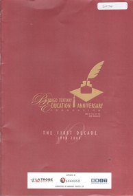
Book - BENDIGO TERTIARY EDUCATION ANNIVERSARY - THE FIRST DECADE 1998-2008, 2008
... BENDIGO TERTIARY EDUCATION ANNIVERSARY - THE FIRST DECADE 1998-2008...'Bendigo Tertiary Education Anniversary - the First Decade 1998-2008. Published by Latrobe University, Bendigo Illustrated with B&W photos. ...Book BENDIGO TERTIARY EDUCATION ANNIVERSARY - THE FIRST DECADE 1998-2008 ...24 page soft cover booklet. 'Bendigo Tertiary Education Anniversary - the First Decade 1998-2008. Published by Latrobe University, Bendigo Illustrated with B&W photos. Includes a history, scholarships and annual reports for the decade.Latrobe Universitylatrobe university, education -
 Greensborough Historical Society
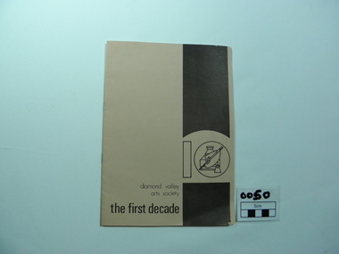
Booklet, The First Decade, 1981_
... The First Decade...A meeting was held in the home of Ron Reynolds on 15th July 1970 with approx. 20 people attending. arts society ron reynolds diamond valley art awards digby watson roland schultz maria schultz murray pulford jan lowe diamond valley arts society Original owner written in pencil as June Hall Two tone light and dark brown cover with artists palette design on the front and sketch of Greensborough Primary School on rear cover The First Decade Booklet Booklet Diamond Valley Arts Society ...Early in the 1970s a number of people felt the need in the Greensborough community for an Arts Society, Prominent among them were were Ron Reynolds, Digby Watson, Murray Pulford, Roland and Maria Schultz. An article appeared in the Greenhills Community News seeking those interested in participating in such a society. A meeting was held in the home of Ron Reynolds on 15th July 1970 with approx. 20 people attending.Two tone light and dark brown cover with artists palette design on the front and sketch of Greensborough Primary School on rear coverOriginal owner written in pencil as June Hall arts society, ron reynolds, diamond valley art awards, digby watson, roland schultz, maria schultz, murray pulford, jan lowe, diamond valley arts society -
 Narre Warren and District Family History Group
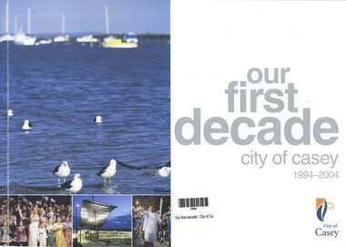
Book, City of Casey, Our First Decade - City of Casey 1994 - 2004, 2004
... Our First Decade - City of Casey 1994 - 2004...Narre Warren and District Family History Group 110 High Street Berwick melbourne Richard Casey Casey Councillors An overview of the events over the ten years 33 p.; 30 cm Our First Decade - City of Casey 1994 - 2004 Book City of Casey ...An overview of the events over the ten years33 p.; 30 cmnon-fictionAn overview of the events over the ten yearsrichard casey, casey councillors -
 Victorian Railway History Library
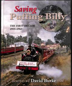
Book, Burke, David, Saving Puffing Billy: The First Decade 1955-1965, 2015
... Saving Puffing Billy: The First Decade 1955-1965...Saving Puffing Billy: The First Decade 1955-1965 Book Burke, David The Puffing Billy Preservation Society ...A history of the restoration of the 2'6" narrow gauge railway from Belgrave to Emerald in Victoria between 1955 to 1965.index, ill, p.217.non-fictionA history of the restoration of the 2'6" narrow gauge railway from Belgrave to Emerald in Victoria between 1955 to 1965.vr narrow gauge railways - victoria - history, puffing billy - victoria - history -
Tatura Irrigation & Wartime Camps Museum
Book, 1880-1890 The First Decade, 1980
... 1880-1890 The First Decade...Illustrated 1880-1890 The First Decade Book Book ...Published in association with the centenary celebrations of the Church of England in Tatura. Author Eric Evans.Soft card dull white cover. Printing in red over reproduction of newspaper advertisements. Illustratedchurch of england, tatura churches, eric evans -
Whitehorse Historical Society Inc.
Document, The First Decade, 1983
... The First Decade...They have a diversity of interests covered by the activity groups. The First Decade Document Document ...History of Nunawading Early Planning For Retirement Group.History of Nunawading Early Planning For Retirement Group. First public meeting held 20 Mar 1974. Previously from a meeting of Nunawading Inter-church Council addressed by Stuart Morris M.B.E., the idea was begun. They have a diversity of interests covered by the activity groups.History of Nunawading Early Planning For Retirement Group. retirement, nunawading early planning for retirement group, nunawading inter-church council, morris, stuart, james, peter -
 Victorian Railway History Library
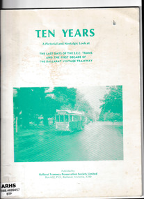
Book, Ballarat Tramway Preservation Society, Ten years: A pictorial and nostalgic look at the last days of the SEC trams and the first decade of the Ballarat vintage tramway, 1981
... Ten years: A pictorial and nostalgic look at the last days of the SEC trams and the first decade of the Ballarat vintage tramway...Tramways - Ballarat Trams - Ballarat - History A pictorial and nostalgic look at the last days of the SEC trams and the first decade of the Ballarat vintage tramway Ill, p.41. ...A pictorial and nostalgic look at the last days of the SEC trams and the first decade of the Ballarat vintage tramwayIll, p.41.non-fiction A pictorial and nostalgic look at the last days of the SEC trams and the first decade of the Ballarat vintage tramwaytramways - ballarat, trams - ballarat - history -
Kilmore Historical Society
Book, Baron Ferdinand von Mueller et al, EUCALYPTOGRAPHIA. First Decade, 1879
... EUCALYPTOGRAPHIA. First Decade....EUCALYPTOGRAPHIA. First Decade. Book Baron Ferdinand von Mueller Baron Ferdinand von Mueller C. ...A descriptive atlas of the Eucalypts of Australia and the adjoining islands.Light card cover with green cloth backstrip to spine, worn at extremities. Widespread foxing and moisture stains throughout. Some insect damage to front pages. Poor condition.non-fictionA descriptive atlas of the Eucalypts of Australia and the adjoining islands.botany, eucalypts, australia -
 Bendigo Historical Society Inc.
Document - CHURCHES OF BENDIGO COLLECTION: ST. ANDREW CHURCH BENDIGO
... A brief account of the activities and achievements during the first decade of the second century of our congregational life....A brief account of the activities and achievements during the first decade of the second century of our congregational life. ...Photocopy of a four pages typewritten document. St. Andrew's Church, Bendigo, April 1964. A brief account of the activities and achievements during the first decade of the second century of our congregational life.church, history, st. andrew's bendigo -
 Sunbury Family History and Heritage Society Inc.
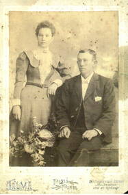
Photograph, Talma Studios, c1890s - 1900s
... The man dressed in a tailored suit is seated and the lady is dressed in clothes fashionable in the first decade of the twentieth century is standing next to the man....The man dressed in a tailored suit is seated and the lady is dressed in clothes fashionable in the first decade of the twentieth century is standing next to the man. ...William Alfred Benzley and his wife Mary are the couple in the photograph. William Alfred was the son of Jacob and Amelia Benzley who were early business people and vignerons in Sunbury. William was the son of Albrecht Rudolph Alfred Bonzil, who had arrived in Australia from Switzerland. Some time after arriving in Australia he must have Anglicised the family name to Benzley.The Benzley family were one of many families who helped to establish the Wine Industry in Sunbury during the nineteenth century. Some of those families were from the Germanic provinces in Europe.A copy of a sepia studio photograph with a light blue border, is of a well-dressed couple. The man dressed in a tailored suit is seated and the lady is dressed in clothes fashionable in the first decade of the twentieth century is standing next to the man.william alfred benzley, amelia benzley, vineyards, sunbury -
 Kew Historical Society Inc
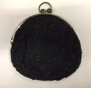
Accessory, Beaded Black Silk Evening Purse, 1900s
... While the note accompanying the item states that it was made and used in the 1880s, the label 'Made in France' would indicate that it was probably made in the first decade of the twentieth century....While the note accompanying the item states that it was made and used in the 1880s, the label 'Made in France' would indicate that it was probably made in the first decade of the twentieth century. Beaded Black Silk Evening Purse Accessory Accessory ...The Kew Historical Society's Fashion & Design collection includes a small and representative collection of reticules, purses and handbags, purchased, inherited or collected by members of the Society. These items date from the Nineteenth and Twentieth centuries, and conform to fashions and styles popular during the period of their use. Some of the items are handmade, while others are mass-produced commercial products. Hand-beaded evening purse, with silver frame and finger ring. While the note accompanying the item states that it was made and used in the 1880s, the label 'Made in France' would indicate that it was probably made in the first decade of the twentieth century.Label: "Made in France / Hand-made". A note which accompanies the item states: "Hand beaded evening purse, 1880s. Frequently used when formal dinner dances were held in the Kew mansions." [Editor - See correct date in Physical description]fashion accessories, clothing accessories, women's clothing -- accessories, bags -- handbags, bags -- purses -
Kew Historical Society Inc
Archive (Sub-series) - Subject File, Kew Historical Society, History of Kew, 1979
... Miscellaneous newspapers and newspapers articles clippings from the last third of the 20th Century and from the first decade of the 21st Century on aspects of Kew’s history. ...Typically files will contain primary and secondary sources. kew historical society - archives kew (vic) - history Miscellaneous newspapers and newspapers articles clippings from the last third of the 20th Century and from the first decade of the 21st Century on aspects of Kew’s history. ...Various partiesReference, Research, InformationSecondary valuesMiscellaneous newspapers and newspapers articles clippings from the last third of the 20th Century and from the first decade of the 21st Century on aspects of Kew’s history. The file contains a copy of the souvenir issue of Progress Press celebrating Kew’s 125th anniversary.kew historical society - archives, kew (vic) - historykew historical society - archives, kew (vic) - history -
 Kew Historical Society Inc
Print, FGA Barnard, Scenes at Kew Flyer Road Race, 1910
... Two photographs related to the Kew Flyer, a bicycle shop in Kew that sponsored a major road race in the first decades of the 20th century. The images were published in Barnard's 'Jubilee History of Kew' (1910) from which Dorothy Rogers sourced the image....Together it forms the largest privately-donated collection within the archives of the Kew Historical Society kew flyer fga barnard dorothy rogers cycling sport Kew Flyer outing. 1 mention - Mansfield's Drags Two photographs related to the Kew Flyer, a bicycle shop in Kew that sponsored a major road race in the first decades of the 20th century. The images were published in Barnard's 'Jubilee History of Kew' (1910) from which Dorothy Rogers sourced the image. ...This work forms part of the collection assembled by the historian Dorothy Rogers, that was donated to the Kew Historical Society by her son John Rogers in 2015. The manuscripts, photographs, maps, and documents were sourced by her from both family and local collections or produced as references for her print publications. Many were directly used by Rogers in writing ‘Lovely Old Homes of Kew’ (1961) and 'A History of Kew' (1973), or the numerous articles on local history that she produced for suburban newspapers. Most of the photographs in the collection include detailed annotations in her hand. The Rogers Collection provides a comprehensive insight into the working habits of a historian in the 1960s and 1970s. Together it forms the largest privately-donated collection within the archives of the Kew Historical SocietyTwo photographs related to the Kew Flyer, a bicycle shop in Kew that sponsored a major road race in the first decades of the 20th century. The images were published in Barnard's 'Jubilee History of Kew' (1910) from which Dorothy Rogers sourced the image.Kew Flyer outing. 1 mention - Mansfield's Dragskew flyer, fga barnard, dorothy rogers, cycling, sport -
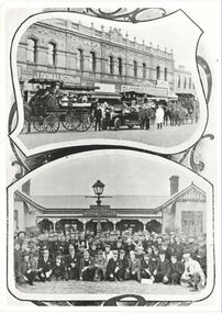
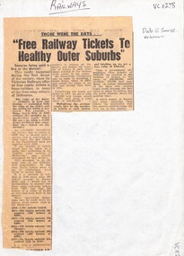 Ringwood and District Historical Society
Newspaper, Free Railway Tickets to healthy Melbourne Outer Suburbs - article about tickets in the early 1900's - Newspaper article, date and source unknown
... Newspaper article on free yearly tickets, offered "during the first decade of the century" to home builders in many of the then outer suburbs of Melbourne - Camberwell, Surrey Hills, Canterbury. ...Ringwood and District Historical Society 125A Warrandyte Road Ringwood North melbourne Newspaper article on free yearly tickets, offered "during the first decade of the century" to home builders in many of the then outer suburbs of Melbourne - Camberwell, Surrey Hills, Canterbury. ...Newspaper article on free yearly tickets, offered "during the first decade of the century" to home builders in many of the then outer suburbs of Melbourne - Camberwell, Surrey Hills, Canterbury. According to calculations in the article, free tickets costing the government £438,450 resulted in the building of houses to the value of £38,300.000 and probably 130,000 new residences. -
Otway Districts Historical Society
portable pulpit or lectern, first decade of 20th Century
... first decade of 20th Century ...The lectern is said to have been used by John Flynn ('Flynn of the Inland' - 1880 - 1951) when he was stationed in the Beech Forest - Lavers Hill area prior to his being ordained as a minister of the Presbyterian Church. Flynn arrived in Beech Forest in 1903 as a home missionary, and for around two years he conducted services in homes, camps and public halls in the Otways. In 1912 Flynn established the Australian Inland Mission, setting up hospitals and hostels across inland Australia, and inspiring the Royal Flying Doctor ServiceThis item was purported to have been used by Reverend John Flynn for services in various locations during his time in the Otways area prior to his more well know work in inland Australia.A blackwood timber pulpit with folding side panels, designed to be portable. Simple carving on centre front panel, and a lectern stand for Bible or other book. Simple trefoil engraving on centre front panel. Small metal plaque reads "Lectern 1910 Lavers Hill Pres. Church. Local Timber by Tom Parsons Esq."john flynn, churches, pulpit -
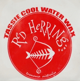 Australian National Surfing Museum
Wax, mid first decade of 2000's
... mid first decade of 2000's ...Red Herring is a Tasmanian based surf store chain. This wax was produced by the company, presumably for promotional purposes. The wax is specifically labelled for Tassie Cool WaterRed Herring surfboard wax. Two blocks of Red Herring brand wax. Front of label: Red Herring Tassie Cool Water Wax Back of label: Stoked to be Surfin'red, surfboard, wax, tassie, herring -
Kew Historical Society Inc
Archive (Series) - Subject File, DAVIES, Emily, 2015
... Suzanne McWha relating to an important donation of items dating from the first decade of the 20th century, prepared by Emily Davies which received ‘plain needlework’ awards. ...Suzanne McWha relating to an important donation of items dating from the first decade of the 20th century, prepared by Emily Davies which received ‘plain needlework’ awards. ...Various partiesReference, Research, InformationSecondary Values (KHS Imposed Order)Subject file which contains a detailed research report prepared by Dr. Suzanne McWha relating to an important donation of items dating from the first decade of the 20th century, prepared by Emily Davies which received ‘plain needlework’ awards. The file contains information about Emily Davies, about Baldur Girls Grammar, about the Plain Needlework Movement. Suzanne includes images and an inventory of each of the items donated.plain sewing competitions, baldur girls' grammar - kew (vic.), suzanne mcwhaplain sewing competitions, baldur girls' grammar - kew (vic.), suzanne mcwha -
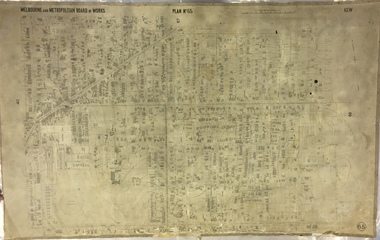
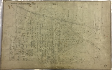
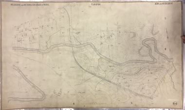 Kew Historical Society Inc
Map, MMBW, MMBW Plan No.64 Kew & Heidelberg, 1900-1910
... Early map of part of the Borough of Kew, created in the first decade of the twentieth century, at a scale 160 ft to 1 inch. ...The vast majority of maps were produced by the MMBW in the first two decades of the twentieth century, and are solid working maps, backed by linen for durability. ...The Melbourne and Metropolitan Board of Works (MMBW) was established by an act of the Victorian Parliament in 1890 to prepare for and to implement a sewerage and water reticulation system across what was then inner Melbourne, its surrounding and middle distance suburbs, including Kew. The MMBW was disbanded in 1991.The map collection of the Kew Historical Society has at its core the historic maps assembled and originally stored in the City Engineer's Department of the City of Kew. These include maps in a number of scales. The vast majority of maps were produced by the MMBW in the first two decades of the twentieth century, and are solid working maps, backed by linen for durability. These maps are historically significant to Kew, the City of Boroondara and to the history of the development of state utilities in Victoria. A number of the Kew maps have additional details added by former municipal officers, including the levels reached by various floods. As these were working documents, information was added to them long after the period of their initial production and distribution.Early map of part of the Borough of Kew, created in the first decade of the twentieth century, at a scale 160 ft to 1 inch. The map covers what was then the northern most part of Kew, bordered on its north and west by the Yarra River, in the East by Connor's Creek and by the Asylum in the south. The map shows the extent of urban development by that time, prominent institutions and the outlines of built structures in the municipality. Contour lines and historic flood levels were added in ink to the map at a later stage.MELBOURNE AND METROPOLITAN BOARD OF WORKS / PLAN NO. 64 / KEW & HEIDELBERGmelbourne & metropolitan board of works, mmbw maps, mmbw plans, borough of kew, cartography -
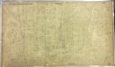
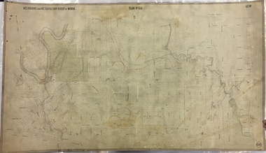
 Kew Historical Society Inc
Map, MMBW, MMBW Plan No.65 Kew & Heidelberg, 1900-1910
... Early map of part of the Borough of Kew, created in the first decade of the twentieth century, at a scale 160 ft to 1 inch. ...The vast majority of maps were produced by the MMBW in the first two decades of the twentieth century, and are solid working maps, backed by linen for durability. ...The Melbourne and Metropolitan Board of Works (MMBW) was established by an act of the Victorian Parliament in 1890 to prepare for and to implement a sewerage and water reticulation system across what was then inner Melbourne, its surrounding and middle distance suburbs, including Kew. The MMBW was disbanded in 1991.The map collection of the Kew Historical Society has at its core the historic maps assembled and originally stored in the City Engineer's Department of the City of Kew. These include maps in a number of scales. The vast majority of maps were produced by the MMBW in the first two decades of the twentieth century, and are solid working maps, backed by linen for durability. These maps are historically significant to Kew, the City of Boroondara and to the history of the development of state utilities in Victoria. A number of the Kew maps have additional details added by former municipal officers, including the levels reached by various floods. As these were working documents, information was added to them long after the period of their initial production and distribution.Early map of part of the Borough of Kew, created in the first decade of the twentieth century, at a scale 160 ft to 1 inch. The map covers what was then the south central part of Kew, bordered on its north by Malmsbury Street, in the west by Florence Avenue, in the south by Barkers Road, and in the east by Princess Street. The map shows the extent of urban development by that time, prominent institutions and the outlines of built structures in the municipality. Contour lines were added in ink to the map at a later stage.MELBOURNE AND METROPOLITAN BOARD OF WORKS / PLAN NO. 65 / KEW & HEIDELBERGmelbourne & metropolitan board of works, mmbw maps, mmbw plans, borough of kew, cartography -
 Kew Historical Society Inc
Map, MMBW, MMBW Plan No.66 Kew, 1900-1910
... Early map of part of the Borough of Kew, created in the first decade of the twentieth century, at a scale 160 ft to 1 inch. ...The vast majority of maps were produced by the MMBW in the first two decades of the twentieth century, and are solid working maps, backed by linen for durability. ...The Melbourne and Metropolitan Board of Works (MMBW) was established by an act of the Victorian Parliament in 1890 to prepare for and to implement a sewerage and water reticulation system across what was then inner Melbourne, its surrounding and middle distance suburbs, including Kew. The MMBW was disbanded in 1991.The map collection of the Kew Historical Society has at its core the historic maps assembled and originally stored in the City Engineer's Department of the City of Kew. These include maps in a number of scales. The vast majority of maps were produced by the MMBW in the first two decades of the twentieth century, and are solid working maps, backed by linen for durability. These maps are historically significant to Kew, the City of Boroondara and to the history of the development of state utilities in Victoria. A number of the Kew maps have additional details added by former municipal officers, including the levels reached by various floods. As these were working documents, information was added to them long after the period of their initial production and distribution.Early map of part of the Borough of Kew, created in the first decade of the twentieth century, at a scale 160 ft to 1 inch. The map covers what was then the south eastern part of Kew, bordered on its north by Adeney Avenue, in the west by Sackville Street, in the south by Barkers Road, and in the east by Burke Road. The map shows the extent of urban development by that time, prominent institutions and the outlines of built structures in the municipality. Contour lines were added in ink to the map at a later stage.MELBOURNE AND METROPOLITAN BOARD OF WORKS / PLAN NO. 66 / KEW melbourne & metropolitan board of works, mmbw maps, mmbw plans, borough of kew, cartography -
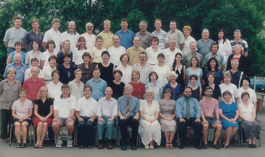 Galen Catholic College
Galen Catholic College Staff: 2000 - 2010
... This is a series of staff photos taken in the first decade of the new millennium at Galen Catholic College....Galen Catholic College 188 - 244 Phillipson Street Wangaratta high-country This is a series of staff photos taken in the first decade of the new millennium at Galen Catholic College. ...This is a series of staff photos taken in the first decade of the new millennium at Galen Catholic College.galen, galen catholic college, galen college, staff -
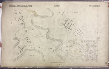 Kew Historical Society Inc
Map, MMBW, MMBW Plan No.39 Kew & Heidelberg, 1900-1910
... Early map of part of the Borough of Kew, created in the first decade of the twentieth century, at a scale 160 ft to 1 inch. ...The vast majority of maps were produced by the MMBW in the first two decades of the twentieth century, and are solid working maps, backed by linen for durability. ...The Melbourne and Metropolitan Board of Works (MMBW) was established by an act of the Victorian Parliament in 1890 to prepare for and to implement a sewerage and water reticulation system across what was then inner Melbourne, its surrounding and middle distance suburbs, including Kew. The MMBW was disbanded in 1991.The map collection of the Kew Historical Society has at its core the historic maps assembled and originally stored in the City Engineer's Department of the City of Kew. These include maps in a number of scales. The vast majority of maps were produced by the MMBW in the first two decades of the twentieth century, and are solid working maps, backed by linen for durability. These maps are historically significant to Kew, the City of Boroondara and to the history of the development of state utilities in Victoria. A number of the Kew maps have additional details added by former municipal officers, including the levels reached by various floods. As these were working documents, information was added to them long after the period of their initial production and distribution.Early map of part of the Borough of Kew, created in the first decade of the twentieth century, at a scale 160 ft to 1 inch. The map covers what was then the north western section of Kew, bordered on its north by Wills Street and the Kew Lunatic Asylum, in the west by the River Yarra [and the later added Yarra Boulevard] , by Princess Street in the East and Holroyd Street in the south. The map shows the extent of urban development by that time, prominent institutions and the outlines of built structures in the municipality. Contour lines were added in ink to the map at a later stage.MELBOURNE AND METROPOLITAN BOARD OF WORKS / PLAN NO. 39 / KEW & HEIDELBERGmelbourne & metropolitan board of works, mmbw maps, mmbw plans, borough of kew, cartography -
 Kew Historical Society Inc
Map, MMBW, MMBW Plan No.67 Kew, 1900-1910
... Early map of part of the Borough of Kew, created in the first decade of the twentieth century, at a scale 160 ft to 1 inch. ...The vast majority of maps were produced by the MMBW in the first two decades of the twentieth century, and are solid working maps, backed by linen for durability. ...The Melbourne and Metropolitan Board of Works (MMBW) was established by an act of the Victorian Parliament in 1890 to prepare for and to implement a sewerage and water reticulation system across what was then inner Melbourne, its surrounding and middle distance suburbs, including Kew. The MMBW was disbanded in 1991.The map collection of the Kew Historical Society has at its core the historic maps assembled and originally stored in the City Engineer's Department of the City of Kew. These include maps in a number of scales. The vast majority of maps were produced by the MMBW in the first two decades of the twentieth century, and are solid working maps, backed by linen for durability. These maps are historically significant to Kew, the City of Boroondara and to the history of the development of state utilities in Victoria. A number of the Kew maps have additional details added by former municipal officers, including the levels reached by various floods. As these were working documents, information was added to them long after the period of their initial production and distribution.Early map of part of the Borough of Kew, created in the first decade of the twentieth century, at a scale 160 ft to 1 inch. The map covers what was then the north central part of Kew, bordered on its north by the Outer Circle Railway Spruzen and Beresford Avenues, in the west by Princess Street, in the south by High Street, and in the east by (about) Belford Road. The map shows the extent of urban development by that time, prominent institutions and the outlines of built structures in the municipality. Contour lines were added in ink to the map at a later stage.MELBOURNE AND METROPOLITAN BOARD OF WORKS / PLAN NO. 67 / KEW melbourne & metropolitan board of works, mmbw maps, mmbw plans, borough of kew, cartography -
 Kew Historical Society Inc
Map, MMBW, MMBW Plan No.68 Kew, 1900-1910
... Early map of part of the Borough of Kew, created in the first decade of the twentieth century, at a scale 160 ft to 1 inch. ...The vast majority of maps were produced by the MMBW in the first two decades of the twentieth century, and are solid working maps, backed by linen for durability. ...The Melbourne and Metropolitan Board of Works (MMBW) was established by an act of the Victorian Parliament in 1890 to prepare for and to implement a sewerage and water reticulation system across what was then inner Melbourne, its surrounding and middle distance suburbs, including Kew. The MMBW was disbanded in 1991.The map collection of the Kew Historical Society has at its core the historic maps assembled and originally stored in the City Engineer's Department of the City of Kew. These include maps in a number of scales. The vast majority of maps were produced by the MMBW in the first two decades of the twentieth century, and are solid working maps, backed by linen for durability. These maps are historically significant to Kew, the City of Boroondara and to the history of the development of state utilities in Victoria. A number of the Kew maps have additional details added by former municipal officers, including the levels reached by various floods. As these were working documents, information was added to them long after the period of their initial production and distribution.Early map of part of the Borough of Kew, created in the first decade of the twentieth century, at a scale 160 ft to 1 inch. The map covers what was then the north central part of Kew, bordered in the north by Oak Avenue, in the west by the Yarra River and Connor's Creek, in the south by Beresford and Carnegie Avenues, and in the east by Glass's Creek and Burke Road. The map shows the extent of urban development by that time, prominent institutions and the outlines of built structures in the municipality. Contour lines and the levels of historic floods were added in ink to the map at a later stage.MELBOURNE AND METROPOLITAN BOARD OF WORKS / PLAN NO. 68 / KEW melbourne & metropolitan board of works, mmbw maps, mmbw plans, borough of kew, cartography -
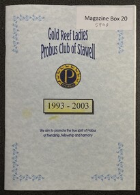 Stawell Historical Society Inc
Booklet, Gold Reef Ladies Probus Club of Stawell 1993 - 2003 1st Decade, April 2003
... First decade of Ladies Probus Club 1993 - 2003. ...First decade of Ladies Probus Club 1993 - 2003. ...First decade of Ladies Probus Club 1993 - 2003. Presidents, Formation, Committee members, Photos, Thoughts of the day - Poems.Soft cover - Pastel blue Cover - Colour - "Gold" and Navy Logo.Gold Reef Ladies Probus Club Stawell 1993-2003 We aim to promote the true spirit of Probus of the friendship, fellowship and harmonyclubs -
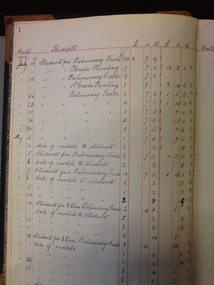 NMIT (Northern Melbourne Institute of TAFE)
Account Book - CTS, Account Book. Collingwood Technical School. 1912-1921
... A day by day register of accounts received and accounts paid at Collingwood Technical School in in its first decade of operations. It does not include salaries. . ...NMIT (Northern Melbourne Institute of TAFE) A day by day register of accounts received and accounts paid at Collingwood Technical School in in its first decade of operations. It does not include salaries. . ...A day by day register of accounts received and accounts paid at Collingwood Technical School in in its first decade of operations. It does not include salaries. . This account book gives the income and expenditure for CTS in the decade from 1912 to 1921.Hard cover account book with green fabric cover and 'leather' corners and spine. Internal pages ruled for accounts.Hand written accounts ledger throughout.collingwood technical school, cts, accounts, account books, nmit, -
 Kew Historical Society Inc
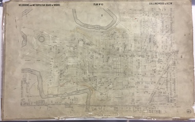
Map, MMBW, MMBW Plan No.40 Collingwood & Kew, 1900-1910
... Early map of part of the Borough of Kew, created in the first decade of the twentieth century, at a scale 160 ft to 1 inch. ...The vast majority of maps were produced by the MMBW in the first two decades of the twentieth century, and are solid working maps, backed by linen for durability. ...The Melbourne and Metropolitan Board of Works (MMBW) was established by an act of the Victorian Parliament in 1890 to prepare for and to implement a sewerage and water reticulation system across what was then inner Melbourne, its surrounding and middle distance suburbs, including Kew. The MMBW was disbanded in 1991.The map collection of the Kew Historical Society has at its core the historic maps assembled and originally stored in the City Engineer's Department of the City of Kew. These include maps in a number of scales. The vast majority of maps were produced by the MMBW in the first two decades of the twentieth century, and are solid working maps, backed by linen for durability. These maps are historically significant to Kew, the City of Boroondara and to the history of the development of state utilities in Victoria. A number of the Kew maps have additional details added by former municipal officers, including the levels reached by various floods. As these were working documents, information was added to them long after the period of their initial production and distribution.Early map of part of the Borough of Kew, created in the first decade of the twentieth century, at a scale 160 ft to 1 inch. The map covers what was then the south western section of Kew, bordered on its north by Studley Park Road, in the west by Walmer Street and the River Yarra, by High Street South and Princess Street in the East and Barkers Road in the south. The map shows the extent of urban development by that time, prominent institutions and the outlines of built structures in the municipality. Contour lines and historic flood levels were added in ink to the map at a later stage.MELBOURNE AND METROPOLITAN BOARD OF WORKS / PLAN NO. 40 / COLLINGWOOD & KEWmelbourne & metropolitan board of works, mmbw maps, mmbw plans, borough of kew, cartography -
 Ringwood and District Historical Society
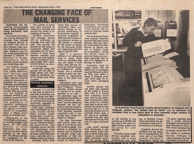
Newspaper - Australia Post Clippings, Ringwood Mail Liftout - July 3, 1985
... "Australia Post - In Perspective" - Brian Moritz, Vic State Manager on first decade operating as a statutory authority. ..."Australia Post - In Perspective" - Brian Moritz, Vic State Manager on first decade operating as a statutory authority. ...Page 16 Advertisement - "The Changing Face of Mail Services" featuring electronic services - Intelpost, Imagegram, Electronic Mail. "Australia Post - In Perspective" - Brian Moritz, Vic State Manager on first decade operating as a statutory authority. Page 17 - "Mail rode coach route" - Operational and staffing history of Ringwood Post Office including list of Postmistresses and Postmasters appointed from 1869 to 1972. Inset photographs with capations - Les McKellar has been postmaster at Ringwood since 1972; Clare Jackson gives philatelic sales department customers a cheery smile.