Showing 157 items matching "flood damage"
-
 Eltham District Historical Society Inc
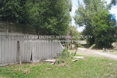
Photograph, Fay Bridge, Flood damage at Nillumbik Medical Centre, 1078 Main Road, Eltham, 26 December 2011
... Flood damage at Nillumbik Medical Centre, 1078 Main Road, Eltham......Flood damage...Flood damage resulting from a late afternoon storm on Christmas Day 2011. ...Eltham District Historical Society Inc 728 Main Rd Eltham melbourne Flood damage resulting from a late afternoon storm on Christmas Day 2011. ...Flood damage resulting from a late afternoon storm on Christmas Day 2011. A flash flood occurred from significant rain fall and hail, which accumulated along an old waterway with floodwater submerging cars along Valonia Drive then down Grove Street flooding houses, through the Bible Street Reserve where it then submerged Main Road washing away the small railway trestle bridge opposite the reserve then flooding the Judge Book Village before finally entering the Diamond Creek..fay bridge collection, 2011-12-26, bible street reserve, flood damage, floods, floodwater, main road, nillumbik medical centre -
 Eltham District Historical Society Inc
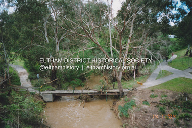
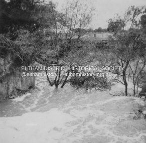
Photograph, Fay Bridge, Flood damage to footbridges over the Diamond Creek, Eltham, 14 November 2004
... Flood damage to footbridges over the Diamond Creek, Eltham......Flood damage...Fay Bridge Collection 2004-11-14 Bridge Street Bridge Diamond Creek (Creek) Diamond Street Bridge Flood damage floods Floodwater Footbridge main road bridge Susan Street Oval Withers Way 5 images - scanned from colour prints on loan Flood damage to footbridges over the Diamond Creek, Eltham Photograph Photograph Fay Bridge ...Significant flood events occurred Nov-Dec 2004 and Jan-Feb 2005.fay bridge collection, 2004-11-14, bridge street bridge, diamond creek (creek), diamond street bridge, flood damage, floods, floodwater, footbridge, main road bridge, susan street oval, withers way -
 University of Melbourne, Burnley Campus Archives
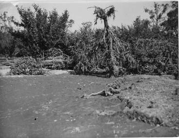
Photograph - Black and white print, A.P. Winzenried, Flood Damage, 1934
... Flood Damage......flood damage...One large tree is upside down with its roots in the air. Flood Damage Photograph Black and white print A.P. ...Appears as an illustration in, "Green Grows Our Garden," A.P. Winzenried p 66. On p. 66 of the text there is further information about the effects of the flood.Black and white photograph. Destruction caused in the Burnley orchards by the 1934 flood of the Yarra River. One large tree is upside down with its roots in the air.On reverse, "1934."orchard, green grows our garden, a.p. winzenried, flood damage, fruit trees -
 Charlton Golden Grains Museum Inc
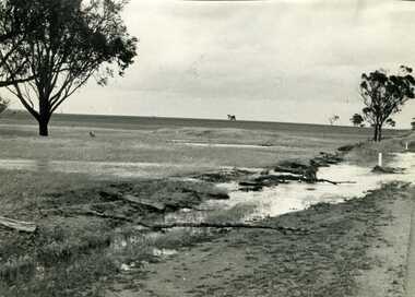
Photograph, Charlton Tribune, Flood Water damage to McGurk's fence, c. 1980
... Flood Water damage to McGurk's fence...Flood 1971, damage to Mc Gurk's fencing on Calder Highway....B/W photo of flood water & damage to McGurk's fence on Calder Highway in 1971 flood....Charlton Golden Grains Museum Inc 1 High Street Charlton goldfields Flood 1971, damage to Mc Gurk's fencing on Calder Highway. ...Flood 1971, damage to Mc Gurk's fencing on Calder Highway.B/W photo of flood water & damage to McGurk's fence on Calder Highway in 1971 flood.calder highway, charlton, floods -
 Eltham District Historical Society Inc
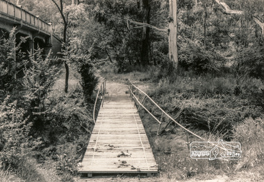
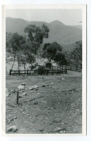
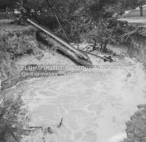
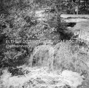
Photograph, Flood damage, Footbridge, Main Road, Eltham
... Flood damage, Footbridge, Main Road, Eltham...Eltham District Historical Society Inc 728 Main Rd Eltham melbourne eltham infrastructure shire of eltham infrastructure bridge Footbridge Main Road floods Black and white photograph Flood damage, Footbridge, Main Road, Eltham Photograph ...Black and white photographeltham, infrastructure, shire of eltham infrastructure, bridge, footbridge, main road, floods -
 Eltham District Historical Society Inc
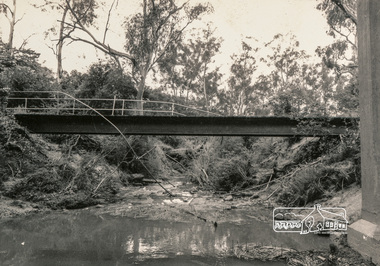
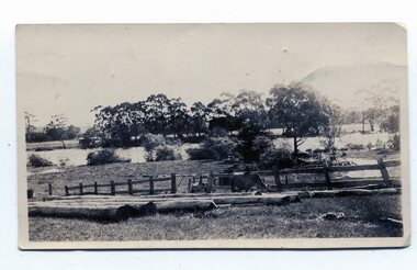
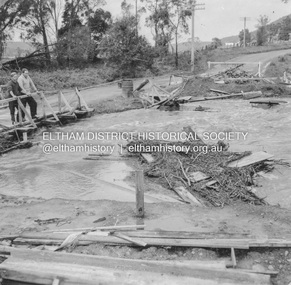
Photograph, Flood damage, Footbridge, Main Road, Eltham
... Flood damage, Footbridge, Main Road, Eltham...Eltham District Historical Society Inc 728 Main Rd Eltham melbourne eltham infrastructure shire of eltham infrastructure bridge footbridge main road floods Black and white photograph Flood damage, Footbridge, Main Road, Eltham Photograph ...Black and white photographeltham, infrastructure, shire of eltham infrastructure, bridge, footbridge, main road, floods -
 Eltham District Historical Society Inc
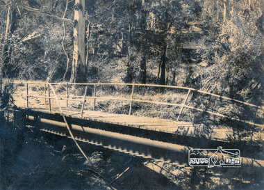
Photograph, Flood damage, Footbridge, Main Road, Eltham
... Flood damage, Footbridge, Main Road, Eltham...Eltham District Historical Society Inc 728 Main Rd Eltham melbourne eltham infrastructure shire of eltham infrastructure bridge footbridge main road floods Black and white photograph Flood damage, Footbridge, Main Road, Eltham Photograph ...Black and white photographeltham, infrastructure, shire of eltham infrastructure, bridge, footbridge, main road, floods -
 University of Melbourne, Burnley Campus Archives
Newspaper - Newspaper Cutting, The Leader, Horticultural Notes, 1891
... ...flood damage...Discussion about what to do to prevent further flood damage such as a breakwater. Mr Neilson, curator, has managed to save the young apple trees....Discussion about what to do to prevent further flood damage such as a breakwater. Mr Neilson, curator, has managed to save the young apple trees. ...Copy of article in "The Leader" (Melbourne) on 22 August, 1891 p 14. Descriptions of members of the Board of Advice for the School of Horticulture and curriculum. Discussion about what to do to prevent further flood damage such as a breakwater. Mr Neilson, curator, has managed to save the young apple trees.the leader, mr neilson, curator, apple trees, school of horticulture, floods, board of advice, flood damage -
 Orbost & District Historical Society
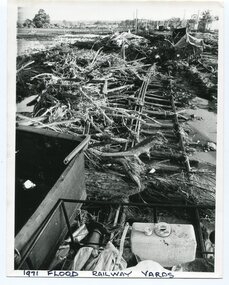
Photograph - 1971 flood, railway yards, Orbost, 1971
... ...1971 flood damage...Two b/w photos of 1971 flood damage at the railway station yards at Orbost. 2731.1 shows a huge amount of debris and upheaval of wagons, railway lines etc. ...Orbost Orbost railway 1971 flood damage Written below both photos: '1971 flood, railway yards, Orbost'. ...This is one of many photos taken following the devastating Snowy River flood of 1971 which inflicted huge impact on the Orbost area, including the Orbost Railway Station yards at Newmerella (Orbost). This photo is significant because it shows the impact of the 1971 Snowy River flood on railway infrastructure at Orbost/Newmerella.Two b/w photos of 1971 flood damage at the railway station yards at Orbost. 2731.1 shows a huge amount of debris and upheaval of wagons, railway lines etc. A large crane is in the background, along with poles. 2731.2 shows debris and some sections of railway line, also parts of wagons. Written below both photos: '1971 flood, railway yards, Orbost'.orbost, orbost railway, 1971 flood damage -
 Orbost & District Historical Society
black and white photographs, 1934
... McKillop's-Bridge Snowy-River flood-damage-1934...These photographs were taken just after the McKillop's Bridge was completed after the flood damage. The current McKillop’s Bridge was built by the Country Roads Board in two stages between 1931-36, during which its height was raised after the original bridge superstructure was washed away in record floods of January 1934, prior to its original official opening. ...McKillop's-Bridge Snowy-River flood-damage-1934 Three black / white photographs. 3133.1 shows the approach to a washed away bridge. 3133.2 is of a bridge over a river with men clearing debris. 3133.3 is a close-up showing the wreckage of the bridge. black and white photographs ...These photographs were taken just after the McKillop's Bridge was completed after the flood damage. The current McKillop’s Bridge was built by the Country Roads Board in two stages between 1931-36, during which its height was raised after the original bridge superstructure was washed away in record floods of January 1934, prior to its original official opening. In its reconstructed form the original concrete abutments were turned into additional piers and the welded-steel trusses were cantilevered back over them to meet the new higher road approaches. It is sited at McKillops Crossing, named after pioneer overlanding squatter George McKillop who crossed here in 1835. This was a stock crossing place for almost a century before the bridge was constructed. (info. from Victoria Heritage Register)This is a pictorial record of the history of McKillop's Bridge, in itself of historical significance for its association with Victoria's long and important pastoral history, its technicl significance and aesthetic significance.Three black / white photographs. 3133.1 shows the approach to a washed away bridge. 3133.2 is of a bridge over a river with men clearing debris. 3133.3 is a close-up showing the wreckage of the bridge.mckillop's-bridge snowy-river flood-damage-1934 -
 Orbost & District Historical Society
black and white photographs, January 1934
... These are photographs taken during the 1934 flood at Orbost. From The Argus (Melbourne) on January 10 1934 "Damage estimated at £500,000 has been caused by the floods in the Orbost district. ...Nine small black / white photographs of flood damage,...Orbost-flood-1934 flood-Orbost 3253.2 on back - "Waters rushing down Princes Highway and....of......where you see the waves" 3253.3 on back - "rushing flood waters over Lochiel Park Bridge approach at the rear of picture 1934" Nine small black / white photographs of flood damage, black and white photographs ...These are photographs taken during the 1934 flood at Orbost. From The Argus (Melbourne) on January 10 1934 "Damage estimated at £500,000 has been caused by the floods in the Orbost district. No loss of life occurred, largely owing to the heroic efforts of rescue parties. Many families spent Monday night on the roofs of houses or in trees, surrounded by deep, rushing flood waters." This 1934 flood was devastating, destroying a section of the 1922 Orbost bridge - the centre span was washed away -. wrecking fences, bridges and roads, dumping silt and debris on the rich river flats and drowning cattle.These photographs are pictorial records of the 1934 floods at Orbost, a significant event in the history of Orbost.Nine small black / white photographs of flood damage,3253.2 on back - "Waters rushing down Princes Highway and....of......where you see the waves" 3253.3 on back - "rushing flood waters over Lochiel Park Bridge approach at the rear of picture 1934"orbost-flood-1934 flood-orbost -
 Wodonga & District Historical Society Inc
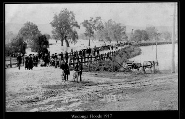
Photograph - Wodonga Floods, Robert Prentice, 1917
... A black and white photograph of people observing the flood damage at Wodonga...Floods Wodonga Natural resources Robert Prentice Wodonga Floods 1917 ЯР A black and white photograph of people observing the flood damage at Wodonga Wodonga Floods Photograph Wodonga Floods Robert Prentice ...THE 1917 floods were the second highest recorded in Albury-Wodonga. The gauge at the Union Bridge was 18 feet. All bridges between Albury and Wodonga were washed away and locals had to travel by train between the two towns. It was the only link between the centres for several weeks. The suspension bridge was a temporary fix to allow pedestrian traffic to travel between Wodonga and Albury. A report from The Argus on October 9, 1917 stated: “For the last three or four months the low-lying land between the border towns of Albury and Wodonga has been almost continuously under water, 150 points were registered here on Thursday and Friday and heavier falls were recorded higher up the river, causing all rivers to rise simultaneously. Residents of Bonegilla, Bethanga, Talgarno and the Murray Valley were cut off from railway facilities. In 2025 this location is now the Lincoln Causeway. This image is one of a collection of photos taken by Robert Prentice. The images are clearly identified as he inscribed in the glass a back-to-front capital R (Я) on to which was joined a capital P creating his mark ЯР.This image is significant because it captures a major flooding event in Wodonga and was taken by a recognised Wodonga photographer.A black and white photograph of people observing the flood damage at WodongaWodonga Floods 1917 ЯРfloods wodonga, natural resources, robert prentice -
 Eltham District Historical Society Inc
Newsclipping, Vince Chadwick, Violent storms shatter the peace of Christmas, The Age, Monday, December 26, p3, 2011
... ...Flood damage...A flash flood occurred from significant rain fall and hail, which accumulated along an old waterway with floodwater submerging cars along Valonia Drive then down Grove Street flooding houses, through the Bible Street Reserve where it then submerged Main Road washing away the small railway trestle bridge opposite the reserve then flooding the Judge Book Village before finally entering the Diamond Creek. Widespread damage occured from hail and flash flooding....Fay Bridge Collection 2011-12-26 Eltham Flood damage floods Grove Street Main Road Valonia Drive Digital file - scanned from newsclipping on loan Violent storms shatter the peace of Christmas, The Age, Monday, December 26, p3 Newsclipping Vince Chadwick The Age ...A late afternoon storm on Christmas Day 2011. A flash flood occurred from significant rain fall and hail, which accumulated along an old waterway with floodwater submerging cars along Valonia Drive then down Grove Street flooding houses, through the Bible Street Reserve where it then submerged Main Road washing away the small railway trestle bridge opposite the reserve then flooding the Judge Book Village before finally entering the Diamond Creek. Widespread damage occured from hail and flash flooding.fay bridge collection, 2011-12-26, eltham, flood damage, floods, grove street, main road, valonia drive -
 Eltham District Historical Society Inc
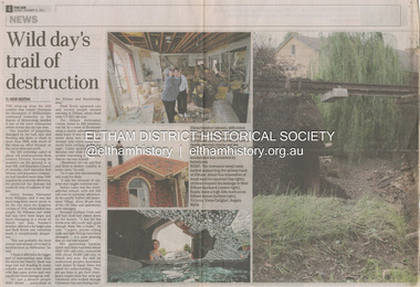
Newsclipping, Reid Sexton, Wild day's trail of destruction, The Age, Tuesday, December 27, pp4-5, 2011
... ...Flood damage...A flash flood occurred from significant rain fall and hail, which accumulated along an old waterway with floodwater submerging cars along Valonia Drive then down Grove Street flooding houses, through the Bible Street Reserve where it then submerged Main Road washing away the small railway trestle bridge opposite the reserve then flooding the Judge Book Village before finally entering the Diamond Creek. Widespread damage occured from hail and flash flooding....Fay Bridge Collection Eltham 2011-12-27 Flood damage floods Floodwater Digital file - scanned from newsclipping on loan Wild day's trail of destruction, The Age, Tuesday, December 27, pp4-5 Newsclipping Reid Sexton The Age ...A late afternoon storm on Christmas Day 2011. A flash flood occurred from significant rain fall and hail, which accumulated along an old waterway with floodwater submerging cars along Valonia Drive then down Grove Street flooding houses, through the Bible Street Reserve where it then submerged Main Road washing away the small railway trestle bridge opposite the reserve then flooding the Judge Book Village before finally entering the Diamond Creek. Widespread damage occured from hail and flash flooding.fay bridge collection, eltham, 2011-12-27, flood damage, floods, floodwater -
 Eltham District Historical Society Inc
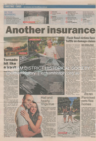
Newsclipping, Angus Thompson et al, Another insurance storm brews, Herald Sun, Tuesday, December 27, pp4-5, 2011
... ...Flood damage...A flash flood occurred from significant rain fall and hail, which accumulated along an old waterway with floodwater submerging cars along Valonia Drive then down Grove Street flooding houses, through the Bible Street Reserve where it then submerged Main Road washing away the small railway trestle bridge opposite the reserve then flooding the Judge Book Village before finally entering the Diamond Creek. Widespread damage occured from hail and flash flooding....Fay Bridge Collection Eltham 2011-12-27 Flood damage floods Floodwater Digital file - scanned from newsclipping on loan Another insurance storm brews, Herald Sun, Tuesday, December 27, pp4-5 Newsclipping Angus Thompson Shannon Deery Harrison Polites Herald Sun ...A late afternoon storm on Christmas Day 2011. A flash flood occurred from significant rain fall and hail, which accumulated along an old waterway with floodwater submerging cars along Valonia Drive then down Grove Street flooding houses, through the Bible Street Reserve where it then submerged Main Road washing away the small railway trestle bridge opposite the reserve then flooding the Judge Book Village before finally entering the Diamond Creek. Widespread damage occured from hail and flash flooding.fay bridge collection, eltham, 2011-12-27, flood damage, floods, floodwater -
 Eltham District Historical Society Inc
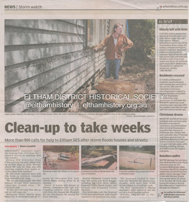
Newsclipping, Shaun Campbell, Clean-up to take weeks, Diamond Valley Leader, December 2011
... ...Flood damage...A flash flood occurred from significant rain fall and hail, which accumulated along an old waterway with floodwater submerging cars along Valonia Drive then down Grove Street flooding houses, through the Bible Street Reserve where it then submerged Main Road washing away the small railway trestle bridge opposite the reserve then flooding the Judge Book Village before finally entering the Diamond Creek. Widespread damage occured from hail and flash flooding....Fay Bridge Collection Eltham Flood damage floods Floodwater Digital file - scanned from newsclipping on loan Clean-up to take weeks, Diamond Valley Leader Newsclipping Shaun Campbell Diamond Valley Leader ...A late afternoon storm on Christmas Day 2011. A flash flood occurred from significant rain fall and hail, which accumulated along an old waterway with floodwater submerging cars along Valonia Drive then down Grove Street flooding houses, through the Bible Street Reserve where it then submerged Main Road washing away the small railway trestle bridge opposite the reserve then flooding the Judge Book Village before finally entering the Diamond Creek. Widespread damage occured from hail and flash flooding.fay bridge collection, eltham, flood damage, floods, floodwater -
 Eltham District Historical Society Inc
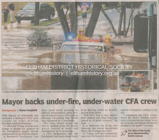
Newsclipping, Shaun Campbell, Mayor backs under-fire, under-water CFA crew, Diamond Valley Leader, December 2011
... ...Flood damage...A flash flood occurred from significant rain fall and hail, which accumulated along an old waterway with floodwater submerging cars along Valonia Drive then down Grove Street flooding houses, through the Bible Street Reserve where it then submerged Main Road washing away the small railway trestle bridge opposite the reserve then flooding the Judge Book Village before finally entering the Diamond Creek. Widespread damage occured from hail and flash flooding....Fay Bridge Collection Eltham Flood damage floods Floodwater Main Road Research Fire Brigade Digital file - scanned from newsclipping on loan Mayor backs under-fire, under-water CFA crew, Diamond Valley Leader Newsclipping Shaun Campbell Diamond Valley Leader ...A late afternoon storm on Christmas Day 2011. A flash flood occurred from significant rain fall and hail, which accumulated along an old waterway with floodwater submerging cars along Valonia Drive then down Grove Street flooding houses, through the Bible Street Reserve where it then submerged Main Road washing away the small railway trestle bridge opposite the reserve then flooding the Judge Book Village before finally entering the Diamond Creek. Widespread damage occured from hail and flash flooding.fay bridge collection, eltham, flood damage, floods, floodwater, main road, research fire brigade -
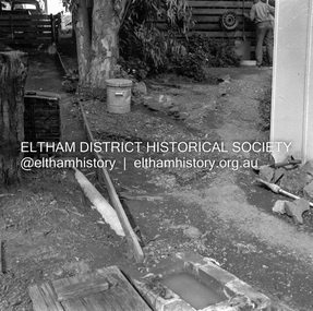
 Eltham District Historical Society Inc
Negative - Photograph, J.A. McDonald, Eltham, Haldane Road, Mar. 1961
... ...Flood damage...Infrastructure shire of eltham 1961-03 Flood damage Haldane Road Prof Donald Thomson Worlingworth Medium format 120/Kodak 620 6x6 cm black and white negative (1 of 12) contained in envelope with various inscriptions and markings Originally inserted loose with other processing envelopes of negatives and prints within a binder of 78 foolscap pages containing a sequence of photos, adhered via glue or sticky tape, with typed or handwritten headings and captions in pencil, contained in a green foolscap binder with spring clasp spine for retaining loose pages. ...Dr Donald Thomson's gate and entrance to his property 'Worlingworth' after flooding in March 1961 "Worlingworth", Eltham, was the home of noted anthropologist the late Professor Donald Thomson and his wife Dorita. The entrance gate on Banoon Road is located at the bottom of the hill opposite Haldane Road. The flooding issues were regularly reported to Council following heavy rain. Google Street View Feb 2014 https://goo.gl/maps/SGjsJAAEdjQXgo5V9Record of various Shire of Eltham infrastructure works undertaken during the period of 1952-1962 involving bridge and road reconstruction projects, sometimes with Eltham Shire Council Project Reference numbers quoted. It was during this period that a number of significant improvements were made to roads and new bridges constructed within the shire that remain in place as of present day (2022). In many situations, the photos provide a tangible visible record of infrastructure that existed throughout the early days of the Shire. The album was put together by or under the direction of the Shire Engineer, J.A. McDonald.infrastructure, shire of eltham, 1961-03, flood damage, haldane road, prof donald thomson, worlingworth -
 Eltham District Historical Society Inc
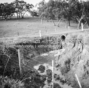
Negative - Photograph, J.A. McDonald, Para Road, Mar. 1961
... ...Flood damage...Infrastructure shire of eltham 1961-03 Flood damage Para Road Medium format 120/Kodak 620 6x6 cm black and white negative (1 of 12) contained in envelope with various inscriptions and markings Originally inserted loose with other processing envelopes of negatives and prints within a binder of 78 foolscap pages containing a sequence of photos, adhered via glue or sticky tape, with typed or handwritten headings and captions in pencil, contained in a green foolscap binder with spring clasp spine for retaining loose pages. ...Wash out 51 Para Road after heavy rain 28 March 1961Record of various Shire of Eltham infrastructure works undertaken during the period of 1952-1962 involving bridge and road reconstruction projects, sometimes with Eltham Shire Council Project Reference numbers quoted. It was during this period that a number of significant improvements were made to roads and new bridges constructed within the shire that remain in place as of present day (2022). In many situations, the photos provide a tangible visible record of infrastructure that existed throughout the early days of the Shire. The album was put together by or under the direction of the Shire Engineer, J.A. McDonald.infrastructure, shire of eltham, 1961-03, flood damage, para road -
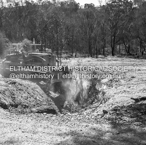 Eltham District Historical Society Inc
Negative - Photograph, J.A. McDonald, Buttermans Track, St Andrews, April 1962
... ...Flood damage...McDonald. 1962-04 bridge construction Buttermans Track Flood damage Infrastructure shire of eltham St Andrews Medium format 120/Kodak 620 6x6 cm black and white negative (1 of 12) contained in a Filmpro processing envelope with various inscriptions and markings. ...LR Bassett P/L filling in scour on Crosby's property Circa April 1962Record of various Shire of Eltham infrastructure works undertaken during the period of 1952-1962 involving bridge and road reconstruction projects, sometimes with Eltham Shire Council Project Reference numbers quoted. It was during this period that a number of significant improvements were made to roads and new bridges constructed within the shire that remain in place as of present day (2022). In many situations, the photos provide a tangible visible record of infrastructure that existed throughout the early days of the Shire. The album was put together by or under the direction of the Shire Engineer, J.A. McDonald.1962-04, bridge construction, buttermans track, flood damage, infrastructure, shire of eltham, st andrews -
 Eltham District Historical Society Inc
Album - Photograph Album, J.A. McDonald, Bridge and Road Reconstruction Works, Shire of Eltham, 1952-1962
... ...Flood damage...Wood Fitzsimons Lane Bridge Flat Rock Road Flood damage floods Floodwater Footpaths and gutters Ford Service Garage G. ...J.A. McDonald produced this record in the course of his responsibilities as Shire Engineer for Eltham Shire Council.Record of various Shire of Eltham infrastructure works undertaken during the period of 1952-1962 involving bridge and road reconstruction projects, sometimes with Eltham Shire Council Project Reference numbers quoted. It was during this period that a number of significant improvements were made to roads and new bridges constructed within the shire that remain in place as of present day (2022). In many situations, the photos provide a tangible visible record of infrastructure that existed throughout the early days of the Shire. The album was put together by or under the direction of the Shire Engineer, J.A. McDonald.a. gillies, alistair knox park, benchmark studies, bend of islands, blease road, box hill state school, box hill teachers college, box hill tip, bridge construction, bridge street bridge, bridge, brisbane street, brougham steet, bulldozer, cecil street, charis pelling, cherry tree road, city of preston, cr. a. brinkkotter, cr. charis pelling, cranes, cromwell street, diamond creek (creek), diamond street, dixons creek bridge, dixon's creek road, drott, eltham leisure centre, eltham north, eltham police station, eltham, eltham-yarra glen road, f. wood, fitzsimons lane bridge, flat rock road, flood damage, floods, floodwater, footpaths and gutters, ford service garage, g. blair, garden hill, glen park bridge, glenauburn road, grand hotel, haldane road, healesville, healesville-yarra glen road, heidelberg-kinglake road, henley road bridge, henley road, hill property, hurstbridge water scheme, hurstbridge, hurstbridge-arthurs creek road, infrastructure, j. jolly, kangaroo ground, kangaroo ground-queenstown road, kangaroo ground-st andrews road, lilydale shire office, long gully bridge, long gully creek, long gully road, long gully, lower plenty bridge, lower plenty footbridge, lower plenty oval, lower plenty road, lower plenty, main road, methodist church, montmorency, mount pleasant road, new holland, old healesville road, opening ceremony, oxley bridge, para road, paul creek bridge, paul creek road, paul krafeznk, pinnacle lane, plaques, plenty river trail, plenty river, presbyterian church, prof donald thomson, pryor street, railway crossing, railway parade, rattray road, reconstruction works, reichelt avenue, research (vic.), research oval, road construction, rymers corner, shire of eltham, shire of whittlesea, silvan road bridge, silver street bridge, silver street, sir dallas brooks, smedley property, st andrews, steels creek, susan street, tarrawarra, tony carberry, uniting church, upper yarra dam, upper yarra reservoir, w.e. wolf, waterfall property, watsons creek, wattletree road bridge, wattletree road, wattletree road bridge, worlingworth, yarra glen, york street, yow yow creek -
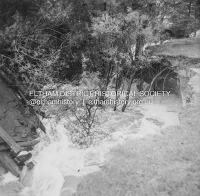 Eltham District Historical Society Inc
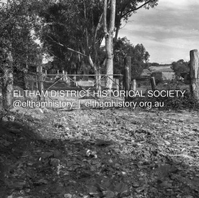
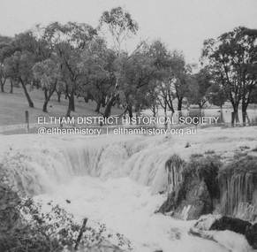
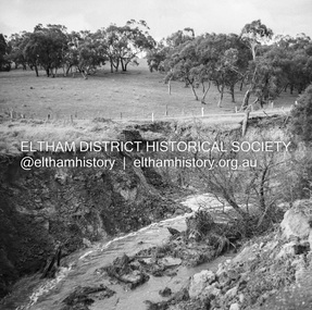
Album - Photograph, J.A. McDonald, Dixons Creek Road, 23 Sep. 1955
... ...Flood damage...McDonald. 1955-09-23 bridge construction Dixons Creek Bridge Dixon's Creek Road Flood damage floods Infrastructure Road construction shire of eltham Black and white photo print (location of negative unknown) Adhered to a page in an album of 78 foolscap pages containing a sequence of photos, adhered via glue or sticky tape, with typed or handwritten headings and captions in pencil. ...Dixons Creek in floodRecord of various Shire of Eltham infrastructure works undertaken during the period of 1952-1962 involving bridge and road reconstruction projects, sometimes with Eltham Shire Council Project Reference numbers quoted. It was during this period that a number of significant improvements were made to roads and new bridges constructed within the shire that remain in place as of present day (2022). In many situations, the photos provide a tangible visible record of infrastructure that existed throughout the early days of the Shire. The album was put together by or under the direction of the Shire Engineer, J.A. McDonald.1955-09-23, bridge construction, dixons creek bridge, dixon's creek road, flood damage, floods, infrastructure, road construction, shire of eltham -
 Eltham District Historical Society Inc
Album - Photograph, J.A. McDonald, Dixons Creek Road, 23 Sep. 1955
... ...Flood damage...McDonald. 1955-09-23 bridge construction Dixons Creek Bridge Dixon's Creek Road Flood damage floods Infrastructure Road construction shire of eltham Black and white photo print (location of negative unknown) Adhered to a page in an album of 78 foolscap pages containing a sequence of photos, adhered via glue or sticky tape, with typed or handwritten headings and captions in pencil. ...Dixons Creek in floodRecord of various Shire of Eltham infrastructure works undertaken during the period of 1952-1962 involving bridge and road reconstruction projects, sometimes with Eltham Shire Council Project Reference numbers quoted. It was during this period that a number of significant improvements were made to roads and new bridges constructed within the shire that remain in place as of present day (2022). In many situations, the photos provide a tangible visible record of infrastructure that existed throughout the early days of the Shire. The album was put together by or under the direction of the Shire Engineer, J.A. McDonald.1955-09-23, bridge construction, dixons creek bridge, dixon's creek road, flood damage, floods, infrastructure, road construction, shire of eltham -
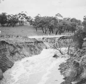
 Eltham District Historical Society Inc
Album - Photograph, J.A. McDonald, Dixons Creek Road, 23 Sep. 1955
... ...Flood damage...McDonald. 1955-09-23 bridge construction Dixons Creek Bridge Dixon's Creek Road Flood damage floods Infrastructure Road construction shire of eltham Black and white photo print (location of negative unknown) Adhered to a page in an album of 78 foolscap pages containing a sequence of photos, adhered via glue or sticky tape, with typed or handwritten headings and captions in pencil. ...Dixons Creek in flood Temporary bridge washed outRecord of various Shire of Eltham infrastructure works undertaken during the period of 1952-1962 involving bridge and road reconstruction projects, sometimes with Eltham Shire Council Project Reference numbers quoted. It was during this period that a number of significant improvements were made to roads and new bridges constructed within the shire that remain in place as of present day (2022). In many situations, the photos provide a tangible visible record of infrastructure that existed throughout the early days of the Shire. The album was put together by or under the direction of the Shire Engineer, J.A. McDonald.1955-09-23, bridge construction, dixons creek bridge, dixon's creek road, flood damage, floods, infrastructure, road construction, shire of eltham -
 Eltham District Historical Society Inc
Album - Photograph, J.A. McDonald, Heidelberg-Kinglake Road, 18 Oct. 1956
... ...Flood damage...Infrastructure shire of eltham bridge construction Heidelberg-Kinglake Road Road construction 1956-10-18 Flood damage floods Floodwater Jehosophat Creek Yarra Glen-Glenburn Road Black and white photo print (location of negative unknown) Adhered to a page in an album of 78 foolscap pages containing a sequence of photos, adhered via glue or sticky tape, with typed or handwritten headings and captions in pencil. ...Yarra Glen-Glenburn Road Jehosophat Creek 18th October 1956Record of various Shire of Eltham infrastructure works undertaken during the period of 1952-1962 involving bridge and road reconstruction projects, sometimes with Eltham Shire Council Project Reference numbers quoted. It was during this period that a number of significant improvements were made to roads and new bridges constructed within the shire that remain in place as of present day (2022). In many situations, the photos provide a tangible visible record of infrastructure that existed throughout the early days of the Shire. The album was put together by or under the direction of the Shire Engineer, J.A. McDonald.infrastructure, shire of eltham, bridge construction, heidelberg-kinglake road, road construction, 1956-10-18, flood damage, floods, floodwater, jehosophat creek, yarra glen-glenburn road -
 Eltham District Historical Society Inc
Negative - Photograph, J.A. McDonald, Dixons Creek, Sep. 1955
... ...Flood damage...McDonald. 1955-09 Dixons Creek Bridge Dixon's Creek Road Flood damage floods Floodwater Infrastructure shire of eltham Medium format 120/Kodak 620 6x6 cm black and white negative (1 of 12) contained with Kodak processing envelope with various inscriptions and markings Originally inserted loose with other processing envelopes of negatives and prints within a binder of 78 foolscap pages containing a sequence of photos, adhered via glue or sticky tape, with typed or handwritten headings and captions in pencil, contained in a green foolscap binder with spring clasp spine for retaining loose pages. ...Record of various Shire of Eltham infrastructure works undertaken during the period of 1952-1962 involving bridge and road reconstruction projects, sometimes with Eltham Shire Council Project Reference numbers quoted. It was during this period that a number of significant improvements were made to roads and new bridges constructed within the shire that remain in place as of present day (2022). In many situations, the photos provide a tangible visible record of infrastructure that existed throughout the early days of the Shire. The album was put together by or under the direction of the Shire Engineer, J.A. McDonald.1955-09, dixons creek bridge, dixon's creek road, flood damage, floods, floodwater, infrastructure, shire of eltham -
 Eltham District Historical Society Inc
Negative - Photograph, J.A. McDonald, Dixons Creek, Sep. 1955
... ...Flood damage...McDonald. 1955-09 Dixons Creek Bridge Dixon's Creek Road Flood damage floods Floodwater Infrastructure shire of eltham Medium format 120/Kodak 620 6x6 cm black and white negative (1 of 12) contained with Kodak processing envelope with various inscriptions and markings Originally inserted loose with other processing envelopes of negatives and prints within a binder of 78 foolscap pages containing a sequence of photos, adhered via glue or sticky tape, with typed or handwritten headings and captions in pencil, contained in a green foolscap binder with spring clasp spine for retaining loose pages. ...Record of various Shire of Eltham infrastructure works undertaken during the period of 1952-1962 involving bridge and road reconstruction projects, sometimes with Eltham Shire Council Project Reference numbers quoted. It was during this period that a number of significant improvements were made to roads and new bridges constructed within the shire that remain in place as of present day (2022). In many situations, the photos provide a tangible visible record of infrastructure that existed throughout the early days of the Shire. The album was put together by or under the direction of the Shire Engineer, J.A. McDonald.1955-09, dixons creek bridge, dixon's creek road, flood damage, floods, floodwater, infrastructure, shire of eltham