Showing 137 items matching "flood waters"
-
 Charlton Golden Grains Museum Inc
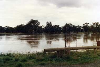
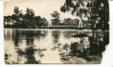
Photograph, Flood Waters Over New Weir - June 1987
... Flood Waters Over New Weir - June 1987...June 1987 Flood waters...Unframed colour photo / glossy. Flood Waters Over New Weir - June 1987 Looking back towards football ground. ...June 1987 Flood waters Unframed colour photo / glossy. Flood Waters Over New Weir - June 1987 Looking back towards football ground. ...Unframed colour photo / glossy. Flood Waters Over New Weir - June 1987 Looking back towards football ground. Dedication monument just in right hand corner of photo. Weir Covered.june 1987 flood waters -
 Charlton Golden Grains Museum Inc
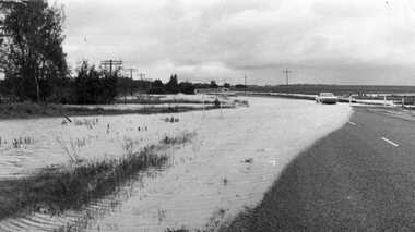
Photograph - 1973 flood waters at Wooroonook, 01/05/2008
... 1973 flood waters at Wooroonook...Flood waters at Wooroonook - 1973. Wycheproof sign in centre of photo with white sedan travelling toward Charlton. ...Photograph 1973 flood waters at Wooroonook ...Flood waters at Wooroonook - 1973. Wycheproof sign in centre of photo with white sedan travelling toward Charlton. Water completely accross road.floods, wooroonook -
 Port Melbourne Historical & Preservation Society
Photograph - Crichton Avenue flood waters, Douglas Smallpage, 1970s
... Crichton Avenue flood waters...B&W photos of various locations in Port Melbourne Crichton Ave flood waters. Shows four girls in bathers sitting in the water. ...Quinn sisters are on left Photograph Crichton Avenue flood waters Douglas Smallpage ...B&W photos of various locations in Port Melbourne Crichton Ave flood waters. Shows four girls in bathers sitting in the water. Quinn sisters are on leftSeveral have descriptions of locations in pencil on rear of photoscrichton avenue, flood, quinn family -
Port Melbourne Historical & Preservation Society
Photograph - Children playing in flood waters, Ingles Street, Port Melbourne, 1940 - 1959
... Children playing in flood waters, Ingles Street, Port Melbourne...Photograph Children playing in flood waters, Ingles Street, Port Melbourne ...Small black and white photo of flood and children playing in the water. Factory CP Consolidated Pneumatic. House 39 Ingles Street 1954(?)built environment - domestic, flood, families, denise flannery o'connor, ingles street -
 Ballaarat Mechanics' Institute (BMI Ballarat)
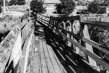
Film - Photograph by Herb Richmond. ca 1971, Skipton- Footbridge Over Emu Creek. No provision on road bridge for foot traffic. Note effect of flood waters
... Note effect of flood waters...Note effect of flood waters Film Photograph by Herb Richmond. ca 1971 ...Ballarat History35mm B&W Kodak Plus X Pan Film.ballarat, ballaraat, skipton, footbridge, emu-creek -
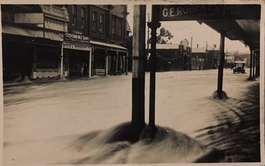
 Kew Historical Society Inc
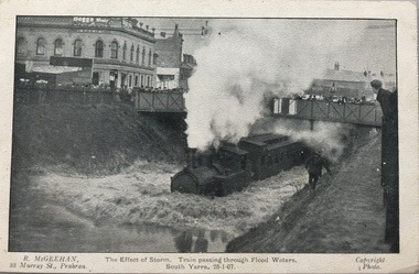
Postcard, R McGeehan, The Effect of Storm. Train Passing Through Flood Waters, South Yarra, 25-1-07, 1907
... Train Passing Through Flood Waters, South Yarra, 25-1-07...Darling-street itself Great Davis-street, and other low-lying and flat thoroughfares in the vicinity became flooded from kerb to kerb, while on the other side of the railway-bridge the valley between Kensington-road and River-street became filled for some minutes to a depth of several feet. Meanwhile the waters...Train Passing Through Flood Waters, South Yarra, 25-1-07 Postcard Postcard R McGeehan ...SHARP DOWNPOUR. ONE INCH IN 45 MINUTES. SOUTHERN SUBURBS DELUGED. TRAIN STOPPED AT SOUTH YARRA. One of the sudden downpours of rain which occasionally fall in Melbourne occurred yesterday afternoon, when nearly an inch of rain fell in the course of three quarters of an hour, and caused a flood for an hour or two in certain localities. During the early part of the day, the sky had been clouded over, but there was nothing to indicate a storm of such intensity as that which followed. At about half-past 1 o'clock residents of South Yarra, South Melbourne, Prahran, and St. Kilda noticed a few drops of rain. Still, it appeared unlikely that there would be anything exceptional, until with startling suddenness at about 10 minutes to 1 o'clock, one of the heaviest downpours within the memory of residents burst upon those suburbs. A strange feature of the storm was that it was practically confined to an area of about three miles square. The city was but little affected, though at a spot as close as the Observatory 86 points of rain were recorded in three-quarters of an hour. Thunder and lightning accompanied the downpour, which was cyclonic in character, the rain driving heavily from all points of the compass as the cyclone passed. It was in South Yarra and Prahran that the rain fell heaviest. Within a few minutes after it commenced, the low-lying portions of Toorak-road and practically the whole length of Chapel-street were under water. The depression at the intersection of Toorak-road and Darling-street speedily filled to the dimensions of a small lake. Several shops were inundated, while the water from the higher levels rushed down like a mountain torrent, and in several in-stances swept through the rear of houses and shops, carrying furniture in a floating mass against the further walls. In one case a footbridge was carried bodily away and dashed to pieces. Darling-street itself Great Davis-street, and other low-lying and flat thoroughfares in the vicinity became flooded from kerb to kerb, while on the other side of the railway-bridge the valley between Kensington-road and River-street became filled for some minutes to a depth of several feet. Meanwhile the waters from South Yarra hill, seeking a lower level, found it in the railway cutting, and the excavations from South Yarra station to Prahran on the one line, and to the Chapel-street bridge on the other, were converted into a couple of canals. At the platforms at South Yarra the water was two feet deep on the permanent way, and towards Hawksburn, at the sudden depression under Chapel-street bridge, it was at one time deep enough to cover a tall man's head. Into this swirling mass of water the 1:50 p.m. train from Oakleigh plunged on its way to Melbourne. The impact caused a mighty fountain of water to rise to a height of about 20 feet above the level of Chapel-street and send clouds of spray in all directions. Under the belief that a terrible explosion had occurred residents braved the rain and rushed to the spot, only to find that the train had been brought to a stand-still in the middle of what seemed to be a river. The water was so high that it had entered the fire-box from below, extinguishing the fires and cutting off the steam supply. In the meantime the officials at the South Yarra station had been preparing for emergencies. Inspectors were on duty at intervals along the line, and the moment the alarm was given an extra engine was backed carefully down and continued on to connect with the stranded train without losing its own power. There was a delay of about ten minutes in the service for an hour or two, but by 5 o'clock all the trains were running on time again, and the water had run off all but the spot beneath the Chapel-street bridge. Here the water remained about four feet deep until nightfall, and throughout the afternoon several hundreds of people including biograph operators and photographers, were gathered around watching each train pass through. Even with the water two feet lower, this was a work attended with considerable difficulty. Each train had to absolutely force its way through the weight of water, almost enveloped by the spray thrown up, and it was only just able to negotiate the "ford" by using every ounce of steam. ... The Argus, 26 January 1907, p19.The item forms part of the Laurie Bennett collection of thirty-six postcards and photographs of Kew and early Melbourne, donated to the Kew Historical Society in 1980. The postcards in the Bennett collection, like other images in the Society's holdings date from the 1890s to the present and comprehensively indicate points-of-view or scenes considered historically, aesthetically or socially significant in the period in which they were produced.Postcard depicting a flood at South Yarra Station in 1907. The title and photographer's name are identified on the front of the postcard. Donated by L. Bennett, 1980flood - south yarra, trains - melbourne, postcards, r mcgeehan - prahran -
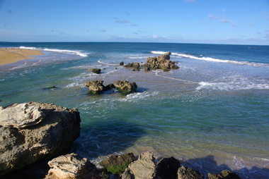 Ballarat Heritage Services
Digital photographs, L.J. Gervasoni, Hopkins River Mouth in flood - waters receeding, c2010 - 2017
... Hopkins River Mouth in flood - waters receeding...flood...geology...coastal geomorphology...waters...Ballarat Heritage Services PO Box 2209 Bakery Hill Post Office goldfields hopkins river mouth point ritchie bluehole warrnambool coast coastal beach seascape flood post flood geology coastal geomorphology waters receeding Hopkins River Mouth in flood - waters receeding Digital photographs L.J. ...hopkins river, mouth, point ritchie, bluehole, warrnambool, coast, coastal, beach, seascape, flood, post flood, geology, coastal geomorphology, waters receeding -
 Wycheproof & District Historical Society Inc.
Photograph, Len Storey, Cooroopajerrup Creek 2011, 17/1/2011 (exact)
... ...flood waters...Digital colour photograph of the Cooroorajerrup Creek, depicting the flood-waters of 2011 surrounding Mount Wycheproof. ...Record flooding on the Avoca River had forced the flood water up the semi-mythical Cooroopajerrup Creek. cooroopajerrup creek mount wycheproof 2011 flood waters Digital colour photograph of the Cooroorajerrup Creek, depicting the flood-waters of 2011 surrounding Mount Wycheproof. ...On Monday January 17th 2011,Wycheproof residents awoke to see the township surrounded by water. Record flooding on the Avoca River had forced the flood water up the semi-mythical Cooroopajerrup Creek. Digital colour photograph of the Cooroorajerrup Creek, depicting the flood-waters of 2011 surrounding Mount Wycheproof. The dwelling in the foreground is the home of Francis and Denise Dillon, barely visible to the left is the Public Hospital.cooroopajerrup creek, mount wycheproof, 2011, flood waters -
 Orbost & District Historical Society
black and white photographs, October 22 1976
... The road to Marlo was cut by flood waters from the Snowy River in two places. ...Nine black / white photographs of flood waters across roads. ...Orbost & District Historical Society Ruskin Street Orbost gippsland The road to Marlo was cut by flood waters from the Snowy River in two places. ...The road to Marlo was cut by flood waters from the Snowy River in two places. The road was closed when water flowed over Gilbert's Gulch (3243.1) The Snowy River broke its banks and flooded surrounding Orbost, Marlo, Lochend and Jarrahmond were isolated. The river bank at the bridge site was broken and filled with earth and rock fill. (3243.2) The new Snowy River Bridge was nearing completion when the river rose 7.2 metres causing erosion on the eastern bank. (3243.7) Contractors involved in the construction of the Princes Freeway and bridge were delayed by the flood waters. (3243.8) The 1976 flood at Orbost was a significant event which delayed the construction of the current Snowy River Road Bridge.These photographs record that event.Nine black / white photographs of flood waters across roads. orbost-flood-1976 snowy-river-bridge marlo-road-flood-1976 gilbert;s-gulch-flood -
 Lakes Entrance Historical Society
Photograph, Bairnsdale Advertiser, East Gippsland Floods 1988, 1/11/1988 12:00:00 AM
... Also two other black and white photographs of raging flood waters during same flood event. 04933.1 10 x 17 cm and 04933.2 18 x 24.5 cm...Black and white photograph showing flood waters flowing through a camping park with two large tents and a caravan surrounded East Gippsland Victoria...Lakes Entrance Historical Society 4 Marine Parade Lakes Entrance gippsland Also two other black and white photographs of raging flood waters during same flood event. 04933.1 10 x 17 cm and 04933.2 18 x 24.5 cm Oil and Gas Industry Black and white photograph showing flood waters flowing through a camping park with two large tents and a caravan surrounded East Gippsland Victoria East Gippsland Floods 1988 Photograph Bairnsdale Advertiser ...Also two other black and white photographs of raging flood waters during same flood event. 04933.1 10 x 17 cm and 04933.2 18 x 24.5 cmBlack and white photograph showing flood waters flowing through a camping park with two large tents and a caravan surrounded East Gippsland Victoriaoil and gas industry -
 Kew Historical Society Inc
Postcard - Flood, Glenferrie Road, Hawthorn, 1921
... Car in distance in flood waters. Real photo postcard...Car in distance in flood waters. Real photo postcard Postcard Flood, Glenferrie Road, Hawthorn ...An item from an outstanding and diverse photographic and postcard collection, assembled by members of the Christian and Washfold families of Kew.Flood waters in Glenferrie Road. Glenferrie Meat Supply – Boyd & Winnett opposite. Car in distance in flood waters. Real photo postcardglenferrie road -- hawthorn (vic.), floods -- hawthorn (vic.), christian-washfold collection -
Kew Historical Society Inc
Postcard - Flood, Glenferrie Road, 1921
... Flood waters in Glenferrie Road. Glenferrie Meat Supply – Boyd & Winnett opposite. ...Car in distance in flood waters. Real photo postcard. Kodak print. ...An item from an outstanding and diverse photographic and postcard collection, assembled by members of the Christian and Washfold families of Kew.Flood waters in Glenferrie Road. Glenferrie Meat Supply – Boyd & Winnett opposite. Car in distance in flood waters. Real photo postcard. Kodak print.glenferrie road -- hawthorn (vic.), floods -- hawthorn (vic.), christian-washfold collection -
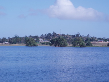
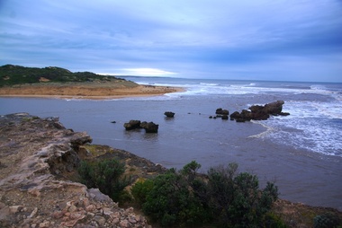 Ballarat Heritage Services
Digital photographs, L.J. Gervasoni, Hopkins River Mouth in flood as the waters receed, c2010 - 2017
... Hopkins River Mouth in flood as the waters receed...flood...geology...coastal geomorphology...waters...Ballarat Heritage Services PO Box 2209 Bakery Hill Post Office goldfields hopkins river mouth point ritchie bluehole warrnambool coast coastal beach seascape flood post flood geology coastal geomorphology waters receeding Colour photograph of the mouth of the Hopkins River at Warrnambool, Hopkins River Mouth in flood as the waters receed Digital photographs L.J. ...Colour photograph of the mouth of the Hopkins River at Warrnambool,hopkins river, mouth, point ritchie, bluehole, warrnambool, coast, coastal, beach, seascape, flood, post flood, geology, coastal geomorphology, waters receeding -
 Chelsea & District Historical Society Inc
Photograph - Chelsea Flood December 1934
... Two Black and white photo of flood waters in Chelsea. ...Chelsea & District Historical Society Inc The Chelsea Activity Hub 3-5 Showers Ave Chelsea 3196 melbourne In December 1934, 700 houses were inundated with water, when the Dandenong Creek and Patterson River broke their banks. flood chelsea Dandenong Creek Nepean Highway Point Nepean Road Two Black and white photo of flood waters in Chelsea. Photograph Chelsea Flood December 1934 ...In December 1934, 700 houses were inundated with water, when the Dandenong Creek and Patterson River broke their banks.Two Black and white photo of flood waters in Chelsea. flood, chelsea, dandenong creek, nepean highway, point nepean road -
 Orbost & District Historical Society
black and white photographs, January 1934
... Many families spent Monday night on the roofs of houses or in trees, surrounded by deep, rushing flood waters." This 1934 flood was devastating, destroying a section of the 1922 Orbost bridge - the centre span was washed away -. wrecking fences, bridges and roads, dumping silt and debris on the rich river flats and drowning cattle....3253.2 on back - "Waters rushing down Princes Highway and....of......where you see the waves" 3253.3 on back - "rushing flood waters over Lochiel Park Bridge approach at the rear of picture 1934"...Orbost-flood-1934 flood-Orbost 3253.2 on back - "Waters rushing down Princes Highway and....of......where you see the waves" 3253.3 on back - "rushing flood waters over Lochiel Park Bridge approach at the rear of picture 1934" Nine small black / white photographs of flood damage, black and white photographs ...These are photographs taken during the 1934 flood at Orbost. From The Argus (Melbourne) on January 10 1934 "Damage estimated at £500,000 has been caused by the floods in the Orbost district. No loss of life occurred, largely owing to the heroic efforts of rescue parties. Many families spent Monday night on the roofs of houses or in trees, surrounded by deep, rushing flood waters." This 1934 flood was devastating, destroying a section of the 1922 Orbost bridge - the centre span was washed away -. wrecking fences, bridges and roads, dumping silt and debris on the rich river flats and drowning cattle.These photographs are pictorial records of the 1934 floods at Orbost, a significant event in the history of Orbost.Nine small black / white photographs of flood damage,3253.2 on back - "Waters rushing down Princes Highway and....of......where you see the waves" 3253.3 on back - "rushing flood waters over Lochiel Park Bridge approach at the rear of picture 1934"orbost-flood-1934 flood-orbost -
 Orbost & District Historical Society
May 1900
... A black / white photograph of a suspension bridge with flood waters below the bridge....This is a pictorial record of an early bridge across the Snowy River at Orbost. orbost-bridge suspension-bridge snowy-river A black / white photograph of a suspension bridge with flood waters below the bridge. ...This is a photograph of the original Orbost / Snowy River Bridge , a suspension bridge which opened in 1893. It has been taken when the Snowy River was in flood. It is similar to other photographs held in The State Library, Victoria. The Snowy River Mail and Tambo and Croajingolong Gazette Sat 12 Aug 1893 records the opening of this bridge as "the most important public event that has yet been commemorated in Eastern ......The Messrs McLeod, with whom the first settlement of this district is generally associated, took up their residence on the eastern bank of the Snowy River about the year 1841 or 42. The late Mr W. Roadknight and Mr T. T. Stirling took possession of the territory on the western side of the Snowy about 35 years ago. During the occupation of the country by cattle owners, very little progress was made in the way of roads and bridges, and except to the hardy and lexperienced bushman, it might have been generally regarded as inaccessible. About the year 1877, however, the late Mr James Robertson eldest son of Mr James Robertson, of Lochend farm, selected land now occupied by his father, about four miles from Orbost on the west bank of the river, Mr John Cameron visited the. district shortly after a .tour of inspection and returned later with his brothers, James and Alick Gameron, but found that during their absence Mr Ernest Watt had found his way on the scene and pegged out a selection, thus anticipating the advent of the Camerons by about 12 hours. We understand that a Mr Kidd, who selected the property now occupied by Mr W. J. Ross, at Pumpkin Point, was one of the earliest batch of settlors.........."This is a pictorial record of an early bridge across the Snowy River at Orbost.A black / white photograph of a suspension bridge with flood waters below the bridge.orbost-bridge suspension-bridge snowy-river -
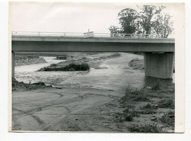
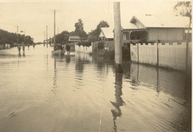
 Sunbury Family History and Heritage Society Inc.
Photograph, Marilyn Bray, 17th December 1985
... A non-digital coloured photograph of flood waters rushing under a bluestone bridge. ... Macedon Street Bridge Jacksons Creek Sunbury A non-digital coloured photograph of flood waters rushing under a bluestone bridge. ...On 17th December 1985, Sunbury and surrounding districts experienced heavy rainfall resulting in the local rivers and waterways flooding.The floodwaters flowing under the Macedon Street bridge at Jackson Creek, almost reached the arches before the waters receded. Some of the low-lying areas in Sunbury had water flowing over the roads as a result of storm water drains overflowing. A non-digital coloured photograph of flood waters rushing under a bluestone bridge. floods, macedon street bridge, jacksons creek, sunbury -
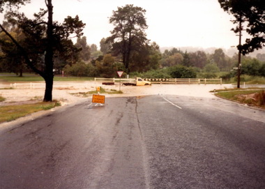 Sunbury Family History and Heritage Society Inc.
Photograph, Marilyn Bray, 17th December 1985
... A non-digital coloured photograph of flood waters across the road ate a T intersection....Floods Ligar Street Riddell Road Sunbury A non-digital coloured photograph of flood waters across the road ate a T intersection. ...On 17th December 1985, heavy tropical rain fell in Sunbury and surrounding areas, causing a lot of flash flooding. The water over the road was at the T intersection of Ligar Street and Riddell Road.A non-digital coloured photograph of flood waters across the road ate a T intersection.floods, ligar street, riddell road, sunbury -
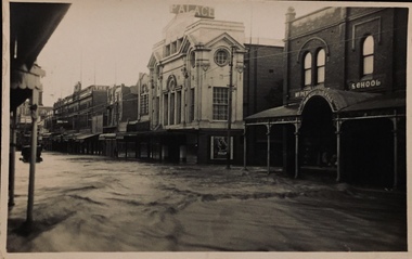
 Kew Historical Society Inc
Postcard - Flood, Glenferrie Road, Hawthorn, 1921
... Flood waters in Glenferrie Road. Palace Cinema at right. ...Kew Historical Society Inc Kew Court House 188 High Street Kew melbourne An item from an outstanding and diverse photographic collection, assembled by members of the Christian and Washfold families of Kew. glenferrie road -- hawthorn (vic.) floods -- hawthorn (vic.) christian-washfold collection Flood waters in Glenferrie Road. Palace Cinema at right. ...An item from an outstanding and diverse photographic collection, assembled by members of the Christian and Washfold families of Kew.Flood waters in Glenferrie Road. Palace Cinema at right. Real photo postcard. Printed by Kodak.glenferrie road -- hawthorn (vic.), floods -- hawthorn (vic.), christian-washfold collection -
 Kew Historical Society Inc
Postcard - Flood, Glenferrie Road, Hawthorn, 1921
... Flood waters in Glenferrie Road. Palace Cinema at right. ...Kew Historical Society Inc Kew Court House 188 High Street Kew melbourne An item from an outstanding and diverse photographic collection, assembled by members of the Christian and Washfold families of Kew. glenferrie road -- hawthorn (vic.) floods -- hawthorn (vic.) christian-washfold collection Flood waters in Glenferrie Road. Palace Cinema at right. ...An item from an outstanding and diverse photographic collection, assembled by members of the Christian and Washfold families of Kew.Flood waters in Glenferrie Road. Palace Cinema at right. Real photo postcard. Kodak printed.glenferrie road -- hawthorn (vic.), floods -- hawthorn (vic.), christian-washfold collection -
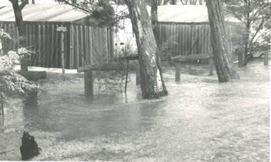
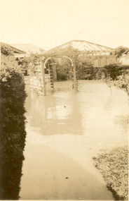 Chelsea & District Historical Society Inc
Photograph - Chelsea Flood December 1934, Carrum Hotel, Nepean Highway
... Black and white photo of flood waters in the garden of Carrum Hotel, showing an archway and in the background is a partially built building....Chelsea & District Historical Society Inc The Chelsea Activity Hub 3-5 Showers Ave Chelsea 3196 melbourne In December 1934, 700 houses were inundated with water, when the Dandenong Creek and Patterson River broke their banks. flood chelsea Dandenong Creek Nepean Highway Point Nepean Road Carrum Hotel Black and white photo of flood waters in the garden of Carrum Hotel, showing an archway and in the background is a partially built building. ...In December 1934, 700 houses were inundated with water, when the Dandenong Creek and Patterson River broke their banks.Black and white photo of flood waters in the garden of Carrum Hotel, showing an archway and in the background is a partially built building.flood, chelsea, dandenong creek, nepean highway, point nepean road, carrum hotel -
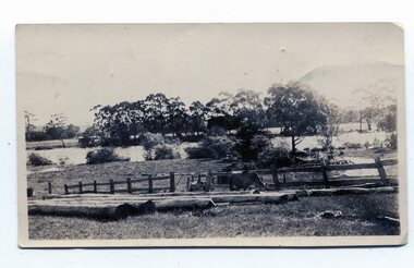
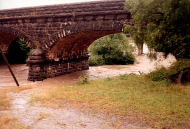
Glenelg Shire Council Cultural Collection
Photograph, c. 1946
... Part of black and white photo, taken from elevated position, showing bridge into Casterton, flood waters either side....Glenelg Shire Council Cultural Collection History House Cliff Street Portland great-ocean-road Sourced from Casterton Town Hall (former Shire of Glenelg) Back: Purple photographer's stamp Part of black and white photo, taken from elevated position, showing bridge into Casterton, flood waters either side. Photograph Photograph J.T. ...Sourced from Casterton Town Hall (former Shire of Glenelg)Part of black and white photo, taken from elevated position, showing bridge into Casterton, flood waters either side.Back: Purple photographer's stamp -
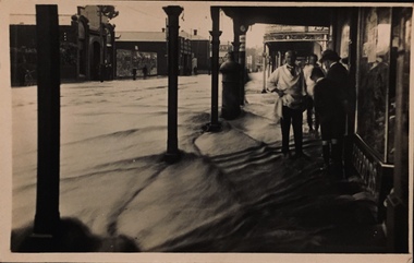 Kew Historical Society Inc
Postcard - Flood, Glenferrie Road, Hawthorn, 1921
... Flood waters in Glenferrie Road. Shopkeeper and bystanders on pavement. ...Kew Historical Society Inc Kew Court House 188 High Street Kew melbourne An item from an outstanding and diverse photographic collection, assembled by members of the Christian and Washfold families of Kew. glenferrie road -- hawthorn floods -- hawthorn (vic.) christian-washfold collection "Dec 1921 / Floods in Glenferrie Rd" Flood waters in Glenferrie Road. Shopkeeper and bystanders on pavement. ...An item from an outstanding and diverse photographic collection, assembled by members of the Christian and Washfold families of Kew.Flood waters in Glenferrie Road. Shopkeeper and bystanders on pavement. Real photo postcard produced by Kodak, probably to a photo by Henry Christian. "Dec 1921 / Floods in Glenferrie Rd"glenferrie road -- hawthorn, floods -- hawthorn (vic.), christian-washfold collection -
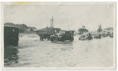 Chelsea & District Historical Society Inc
Photograph - Chelsea Flood December 1934, Point Nepean Road (Nepean Highway)
... Black and white photo of flood waters across Point Nepean Road (now Nepean Highway). ...Chelsea & District Historical Society Inc The Chelsea Activity Hub 3-5 Showers Ave Chelsea 3196 melbourne In December 1934, 700 houses were inundated with water, when the Dandenong Creek and Patterson River broke their banks. flood chelsea Dandenong Creek Nepean Highway Point Nepean Road Black and white photo of flood waters across Point Nepean Road (now Nepean Highway). ...In December 1934, 700 houses were inundated with water, when the Dandenong Creek and Patterson River broke their banks.Black and white photo of flood waters across Point Nepean Road (now Nepean Highway). Cars and trucks are driving through the water.flood, chelsea, dandenong creek, nepean highway, point nepean road -
 Chelsea & District Historical Society Inc
Photograph - Chelsea Flood December 1934, Corner of Sherwood Avenue and Fowler Street
... A person is on course back riding through the flood waters....A person is on course back riding through the flood waters. Corner of Sherwood Avenue and Fowler Street Photograph Chelsea Flood December 1934 ...In December 1934, 700 houses were inundated with water, when the Dandenong Creek and Patterson River broke their banks.Black and white photo of water inundating a shop on the corner of Sherwood Avenue and Fowler Street, Chelsea. A person is on course back riding through the flood waters.flood, chelsea, dandenong creek, fowler street, sherwood avenue -
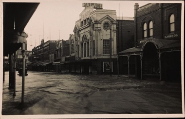
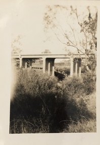
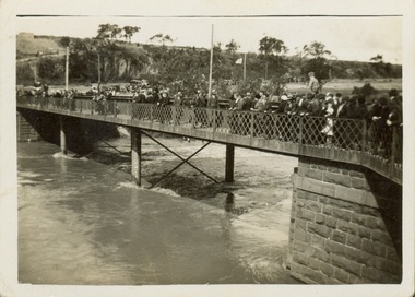 Kew Historical Society Inc
Photograph - Second Johnston Street Bridge in Flood, 1934
... Original, small black and white print photograph of crowds lining the Johnston Street Bridge watching the flood waters below. The annotation on the reverse clarifies that Kew is in the distance....Original, small black and white print photograph of crowds lining the Johnston Street Bridge watching the flood waters below. The annotation on the reverse clarifies that Kew is in the distance. ...Original, small black and white print photograph of crowds lining the Johnston Street Bridge watching the flood waters below. The annotation on the reverse clarifies that Kew is in the distance.Annotated on reverse: "Gift of G.S. Beard / 2nd bridge / Johnston St. Studly Park Rd. Bridge looking towards Kew / 1st bridge 1858–1876, 2nd bridge built (bad bend), 1876–1958, 3rd bridge 1958, lined up Johnston St and Studley Park Rd."johnston street bridge, bridges - yarra river -- kew (vic.), flood -- 1934 -
 Lakes Entrance Historical Society
Photograph - Home of Fish Family, Roadknight Street Lakes Entrance c1926
... Black and white photograph of a small fibro clad house built for Vic and Myrtle Fish surrounded by receeding flood waters in Roadknight Street Lakes Entrance Victoria...Became shell museum 1960 to 70s for Mrs Newmans Camp Park named Gelia changed to Echo Beach, had various owners Houses Genealogy Floods Black and white photograph of a small fibro clad house built for Vic and Myrtle Fish surrounded by receeding flood waters in Roadknight Street Lakes Entrance Victoria Photograph Home of Fish Family, Roadknight Street Lakes Entrance c1926 ...Also an enlarged copy of same photograph 05006.1 Built by J C Dahlsen for Vic Fish and family. Became shell museum 1960 to 70s for Mrs Newmans Camp Park named Gelia changed to Echo Beach, had various ownersBlack and white photograph of a small fibro clad house built for Vic and Myrtle Fish surrounded by receeding flood waters in Roadknight Street Lakes Entrance Victoriahouses, genealogy, floods -
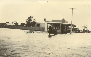
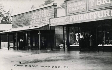 Wodonga & District Historical Society Inc
Photograph - Chiltern Floods, Thomas Bonsema, 1919
... Three black and white images of Chiltern under flood waters on 27th December 1919. The building on the left in photo number 1 is the business premises of T. ...Bonsema Photography Thomas Peter John Bonsema Chiltern floods CONNESS ST IN FLOOD 27 12 19, TB Three black and white images of Chiltern under flood waters on 27th December 1919. The building on the left in photo number 1 is the business premises of T. ...Chiltern is situated on the Black Dog Creek was originally known as the Black Dog township. It was officially gazetted as a town in 185. During 1853-54 the name was changed to Chiltern due to the resemblance of the countryside to Chiltern Hills in England. The first township lots were sold in June 1854. After the goldrushes Chiltern remained a prosperous community with a thriving economy based on agriculture, timber, and small enterprises. Born in Wodonga, after his marriage Thomas Peter Bonsema operated his photography business in Chiltern. Our Collection includes several photographs signed BONSEMA WODONGA or sometimes simply TBW. Thomas Peter John Bonsema was born in Wodonga in 1876 to Peter John Bonsema and Mary Ann nee Nash. His name first appears on the Electoral Roll for Wodonga in 1909 and on the Electoral Roll in 1912 he is listed as a photographer. His photographs capture many scenes and events around Wodonga and surrounding areas. Thomas Bonsema married Minna Louisa Jones in 1912. By 1914 he had moved to Chiltern, Victoria where he established Bonsema’s Photographic Studio. From this time onward many of his works bore the signature “BONSEMA CHILTERN”. As well as continuing to photograph landscapes and important buildings, Mr Bonsema was often the official photographer at school and community celebrations. He also sold many framed photographs and postcards from his premises at 68 -70 Conness Street, Chiltern. By 1943 Thomas John Bonsema had relocated to New South Wales and died in Beecroft, NSW on 14th July 1944. Some of his photographs are held in the Victorian State Library and Mitchell Library Sydney Collections.These images are significant because they are the work of a recognised photographer Thomas Bonsema who was born in Wodonga in 1876. Three black and white images of Chiltern under flood waters on 27th December 1919. The building on the left in photo number 1 is the business premises of T. Bonsema, Photographer.CONNESS ST IN FLOOD 27 12 19, TBbonsema photography, thomas peter john bonsema, chiltern floods -
 Kew Historical Society Inc
Photograph, Burke Road Bridge, 1930s
... The previous bridge, constructed in 1926 was submerged beneath the flood waters in the 1934 mega-flood of the Yarra....The previous bridge, constructed in 1926 was submerged beneath the flood waters in the 1934 mega-flood of the Yarra. ...Without bridges, Kew remained cut off from the City of Melbourne, only being accessible by Punt. Private and public bridges were constructed from the 1850s, beginning with the Hawthorn Bridge linking Bridge and Burwood Roads. A bridge across the Yarra at Burke Road was created as early as 1873. Since that first wooden bridge, a number of later bridges, typically on concrete pylons have been built, in 1926 and again during the 1970s.Sepia, faded photograph of the Burke Road Bridge linking East Kew and Ivanhoe. The previous bridge, constructed in 1926 was submerged beneath the flood waters in the 1934 mega-flood of the Yarra.burke road bridge (kew), bridges -- river yarra -
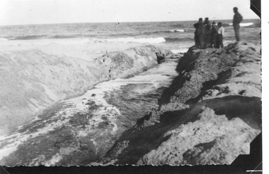 Lakes Entrance Historical Society
Photograph - Lake Tyers Victoria c1930
... Black and white photograph of a group of people standing at the outlet of a trench which has been dug by hand to allow the flood waters of the lake to escape to the sea. ...Lake Tyers is usually isolated from the ocean by a sandbar, when flooding of the lake system occurs, it is necessaary to manually open the bar Waterways Natural Disasters Floods Black and white photograph of a group of people standing at the outlet of a trench which has been dug by hand to allow the flood waters of the lake to escape to the sea. ...Lake Tyers is usually isolated from the ocean by a sandbar, when flooding of the lake system occurs, it is necessaary to manually open the barBlack and white photograph of a group of people standing at the outlet of a trench which has been dug by hand to allow the flood waters of the lake to escape to the sea. Lake Tyers Victoriawaterways, natural disasters, floods