Showing 2182 items matching "flooding"
-
 Tatura Irrigation & Wartime Camps Museum
Photograph, 1955 flooding, 1955
... 1955 flooding...Sacred Heart Primary School, Tatura, surrounded by flood waters, 1955. School later demolished....Black and white photograph of flooding, Sacred Heart Primary School, Tatura, 1955....on back: Sacred Heart Primary School, Tatura. Flood. 1955....Flood. 1955. Black and white photograph of flooding, Sacred Heart Primary School, Tatura, 1955. 1955 flooding Photograph ...Sacred Heart Primary School, Tatura, surrounded by flood waters, 1955. School later demolished.Black and white photograph of flooding, Sacred Heart Primary School, Tatura, 1955.on back: Sacred Heart Primary School, Tatura. Flood. 1955. -
 Melbourne Tram Museum
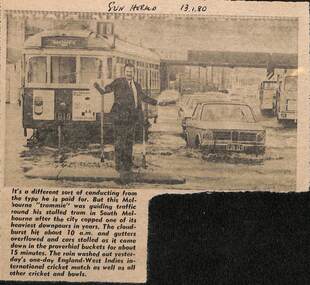
Newspaper, Herald Sun, Newspaper clipping re flooding in South Melbourne, 13-1-1980
... Newspaper clipping re flooding in South Melbourne......flooding...Newspaper cutting about flooding in South Melbourne disabling a tram and a "trammie" conductor or driver, directing traffic. ...Newspaper cutting from the Herald Sun 13-1-1980 about flooding in South Melbourne and delaying tram W7 1019...Yields information about the type of delays that can occur on a big tram system. trams tramways tramcars flooding floods South Melbourne W7 1019 Route 10 crews "Sun Herald 13.1.80" Newspaper cutting from the Herald Sun 13-1-1980 about flooding in South Melbourne and delaying tram W7 1019 Newspaper clipping re flooding in South Melbourne Newspaper Vic Melbourne Herald Sun ...Newspaper cutting about flooding in South Melbourne disabling a tram and a "trammie" conductor or driver, directing traffic. Tram W7 1019, route 10.Yields information about the type of delays that can occur on a big tram system.Newspaper cutting from the Herald Sun 13-1-1980 about flooding in South Melbourne and delaying tram W7 1019"Sun Herald 13.1.80"trams, tramways, tramcars, flooding, floods, south melbourne, w7 1019, route 10, crews -
 Kew Historical Society Inc
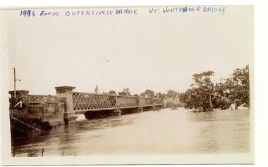
Photograph, Flooding of the Outer Circle Railway Bridge, 1934
... Flooding of the Outer Circle Railway Bridge...One of three digital copies of flooded areas of Kew (1923-34), donated by Jan Coutts of Bulleen in 2019. ...1934 FLOODS / OUTER CIRCLE BRIDGE / WE WENT UNDER BRIDGE OUTER CIRCLE BRIDGE / 1934 FLOODS / (DAD & I) / WE TOOK OUR CANOE UNDER THE BRIDGE, & CARL SIERAKOSKI WAS IN HIS CANOE AT THE TIME & WROTE DADS NAME A. ...Kew Historical Society Inc Kew Court House 188 High Street Kew melbourne floods - kew - 1934 1934 FLOODS / OUTER CIRCLE BRIDGE / WE WENT UNDER BRIDGE OUTER CIRCLE BRIDGE / 1934 FLOODS / (DAD & I) / WE TOOK OUR CANOE UNDER THE BRIDGE, & CARL SIERAKOSKI WAS IN HIS CANOE AT THE TIME & WROTE DADS NAME A. ...One of three digital copies of flooded areas of Kew (1923-34), donated by Jan Coutts of Bulleen in 2019. The handwriting on the originals predates the copy.1934 FLOODS / OUTER CIRCLE BRIDGE / WE WENT UNDER BRIDGE OUTER CIRCLE BRIDGE / 1934 FLOODS / (DAD & I) / WE TOOK OUR CANOE UNDER THE BRIDGE, & CARL SIERAKOSKI WAS IN HIS CANOE AT THE TIME & WROTE DADS NAME A. LUCKE UNDER THE TOP OF THE BRIDGE / NEE (MARY LUCKE) NOW TYACKfloods - kew - 1934 -
Ballarat Heritage Services
Film - Flooding at Hepburn Mineral Springs Reserve October 7 2022, Lisa Gervasoni, Video of flooding on Wild Cat Creek, 07/10/2022
... Video of flooding on Wild Cat Creek...After a rainstorm on 05 October the creek flooded, covering the mineral water springs at Hepburn Springs Reserve....Flooding at Wild Car Creek at Hepburn Mineral Springs Reserve ...Flooding at Hepburn Mineral Springs Reserve Hepburn Springs Reserve. mineral water wild cat creek locarno mineral water spring Flooding at Wild Car Creek at Hepburn Mineral Springs Reserve Video of flooding on Wild Cat Creek Film Flooding at Hepburn Mineral Springs Reserve October 7 2022 Lisa Gervasoni ...Wild Car Creek usually gently flows through Hepburn Springs Reserve. After a rainstorm on 05 October the creek flooded, covering the mineral water springs at Hepburn Springs Reserve.Flooding at Wild Car Creek at Hepburn Mineral Springs Reserve flooding at hepburn mineral springs reserve, hepburn springs reserve., mineral water, wild cat creek, locarno mineral water spring -
Tatura Irrigation & Wartime Camps Museum
Photograph - copy, 1955 flooding Tatura, 1955
... 1955 flooding Tatura...Copy of photograph of Eric Welch's Newsagency, part of Cussen House and saddlers store during flooding of Hogan Street Tatura 1955. ...Black and white photograph of shops in Hogan Street, Tatura, during 1955 flooding...Tatura Irrigation & Wartime Camps Museum 49 Hogan Street Tatura the-murray Copy of photograph of Eric Welch's Newsagency, part of Cussen House and saddlers store during flooding of Hogan Street Tatura 1955. Eric Welch Newsagency Flooding Hogan Street Tatura 1955 Cussen House Eric Welch's Newsagency February 1955 Black and white photograph of shops in Hogan Street, Tatura, during 1955 flooding 1955 flooding Tatura Photograph - copy ...Copy of photograph of Eric Welch's Newsagency, part of Cussen House and saddlers store during flooding of Hogan Street Tatura 1955. Black and white photograph of shops in Hogan Street, Tatura, during 1955 floodingEric Welch's Newsagency February 1955eric welch newsagency, flooding hogan street tatura 1955, cussen house -
 Eltham District Historical Society Inc
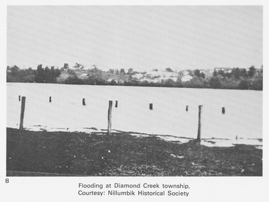
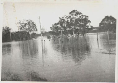
Work on paper (Sub-Item) - Photograph, Flooding at Diamond Creek Township
... Flooding at Diamond Creek Township......flooding...Black and white photograph of the Diamond Creek in flood at Diamond Creek township in 1934. In 1934 extensive flooding of the Yarra River and Diamond Creek set new records for flood plain level (Eltham Chronology EDHS) Nillumbik Historical Society collection...Eltham District Historical Society Inc 728 Main Rd Eltham melbourne Black and white photograph of the Diamond Creek in flood at Diamond Creek township in 1934. In 1934 extensive flooding of the Yarra River and Diamond Creek set new records for flood plain level (Eltham Chronology EDHS) Nillumbik Historical Society collection flood diamond creek flooding Nillumbik Historical Society Image printed on A4 page from 04997 Diamond Creek Basin Study, 1980 Flooding at Diamond Creek Township Work on paper Photograph ...Black and white photograph of the Diamond Creek in flood at Diamond Creek township in 1934. In 1934 extensive flooding of the Yarra River and Diamond Creek set new records for flood plain level (Eltham Chronology EDHS) Nillumbik Historical Society collectionflood, diamond creek, flooding, nillumbik historical society -
 Eltham District Historical Society Inc
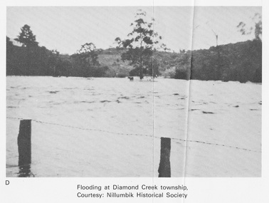
Work on paper (Sub-Item) - Photograph, Flooding at Diamond Creek Township
... Flooding at Diamond Creek Township......flooding...Black and white photograph of the Diamond Creek in flood at Diamond Creek township in 1934. In 1934 extensive flooding of the Yarra River and Diamond Creek set new records for flood plain level (Eltham Chronology EDHS) Nillumbik Historical Society collection...Eltham District Historical Society Inc 728 Main Rd Eltham melbourne Black and white photograph of the Diamond Creek in flood at Diamond Creek township in 1934. In 1934 extensive flooding of the Yarra River and Diamond Creek set new records for flood plain level (Eltham Chronology EDHS) Nillumbik Historical Society collection flood diamond creek flooding Nillumbik Historical Society Image printed on A4 page from 04997 Diamond Creek Basin Study, 1980 Flooding at Diamond Creek Township Work on paper Photograph ...Black and white photograph of the Diamond Creek in flood at Diamond Creek township in 1934. In 1934 extensive flooding of the Yarra River and Diamond Creek set new records for flood plain level (Eltham Chronology EDHS) Nillumbik Historical Society collectionflood, diamond creek, flooding, nillumbik historical society -
![Flooding at Chipperfield's Boathouse [East Kew], 1934](/media/collectors/550653872162f11fb04854aa/items/58cbaad5d0cec425b474bfb1/item-media/58cf6fbdd0cf9f331490feb0/item-fit-380x285.jpg?cb=6) Kew Historical Society Inc
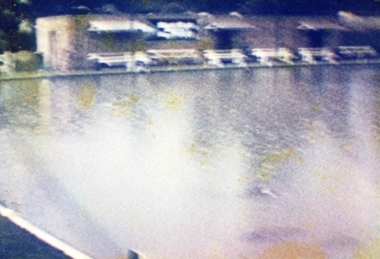
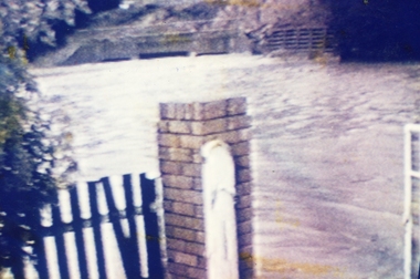
Kew Historical Society IncPhotograph, Flooding at Chipperfield's Boathouse, 1934
... Flooding at Chipperfield's Boathouse...Newspapers continued to describe major flooding in Kew in 1863, 1869, 1878, 1880, 1889, 1891, 1916 and 1934. ...The flood reached the roof of the Moorings, which can be seen in the photo....Numerous photographs record flooding throughout the Twentieth Century. floods (kew) floods (kew) 1934 yarra river Floods in North Kew, 1934. ...Living with natural processes was frequently a challenge to early European settlers and later residents of what was in the 1850s administered by the Borondara Road Board. This was compounded by the area being bounded on three sides by rivers (Yarra River, Koonung Creek and Gardiner's Creek). In 1849, the historian James Bonwick recorded that "our district [Kew] suffered considerably. Mr Wade speaks of 80 acres, out of 100 acres of his cultivated paddock, covered by water." Newspapers continued to describe major flooding in Kew in 1863, 1869, 1878, 1880, 1889, 1891, 1916 and 1934. While the construction of the Upper Yarra dam in 1957 reduced the levels of flowing downstream, local and riverine floods continue.The Kew Historical Society's pictures and map collections testify to the impact of flooding in the district. They have historical importance in documenting the extent of flooding in the district and its affects on homes, services and recreation. Numerous photographs record flooding throughout the Twentieth Century.Floods in North Kew, 1934. Chipperfield's Boathouse and the adding Moorings was located beside the Yarra River near the corner of Willsmere and Kilby Roads. The flood reached the roof of the Moorings, which can be seen in the photo.floods (kew), floods (kew) 1934, yarra river -
 Eltham District Historical Society Inc
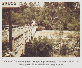
Work on paper (Sub-Item) - Photograph, Flooding, View of Diamond Street Bridge, Eltham 8 April 1977
... Flooding, View of Diamond Street Bridge, Eltham 8 April 1977......flooding...Colour photograph. Flooding of Diamond Creek at Diamond Street Eltham bridge approximately 2 1/2 hours after the flood peak. ...Eltham District Historical Society Inc 728 Main Rd Eltham melbourne Colour photograph. Flooding of Diamond Creek at Diamond Street Eltham bridge approximately 2 1/2 hours after the flood peak. ...Colour photograph. Flooding of Diamond Creek at Diamond Street Eltham bridge approximately 2 1/2 hours after the flood peak. Note debris on the bridge deck. 8 April 1977. flood, diamond creek, flooding, eltham, diamond street, bridge -
 Eltham District Historical Society Inc
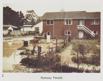
Work on paper (Sub-Item) - Photograph, Flooding, 75 Railway Parade, Eltham 8 April 1977
... Flooding, 75 Railway Parade, Eltham 8 April 1977......flooding...Colour photograph. Flooding of Diamond Creek at the rear and side of property at 75 Railway Parade, Eltham , 8 April 1977. ...Eltham District Historical Society Inc 728 Main Rd Eltham melbourne Colour photograph. Flooding of Diamond Creek at the rear and side of property at 75 Railway Parade, Eltham , 8 April 1977. flood diamond creek flooding eltham 75 Railway Parade Image printed on A4 page from 04997 Diamond Creek Basin Study, 1980 Flooding, 75 Railway Parade, Eltham 8 April 1977 Work on paper Photograph ...Colour photograph. Flooding of Diamond Creek at the rear and side of property at 75 Railway Parade, Eltham , 8 April 1977. flood, diamond creek, flooding, eltham, 75 railway parade -
 Whitehorse Historical Society Inc.
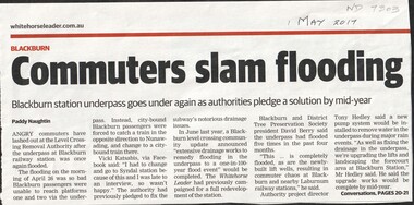
Article, Commuters slam flooding, 2017
... Commuters slam flooding...This is the fifth time it has flooded in the past 4 months....This is the fifth time it has flooded in the past 4 months. Commuters slam flooding Article Article ...The underpass at Blackburn railway station flooded again on the morning of Apr 26th preventing passengers from boarding city bound trains. This is the fifth time it has flooded in the past 4 months.level crossing removal authority, blackburn railway station -
Ballarat Heritage Services
Film - MP4 video of Flooding Hepburn Mineral Springs Reserve 13 October 2022, LJ Gervasoni, Flooding Hepburn Mineral Springs Reserve 13 October 2022
... Flooding Hepburn Mineral Springs Reserve 13 October 2022...MP4 video clips of flooding at Hepburn Mineral Springs 13 October 2022...Ballarat Heritage Services PO Box 2209 Bakery Hill Post Office goldfields MP4 video clips of flooding at Hepburn Mineral Springs 13 October 2022 Flooding Hepburn Mineral Springs Reserve 13 October 2022 Film MP4 video of Flooding Hepburn Mineral Springs Reserve 13 October 2022 LJ Gervasoni ...MP4 video clips of flooding at Hepburn Mineral Springs 13 October 2022 -
 Eltham District Historical Society Inc
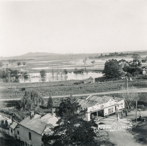
Photograph, Flooding at Yarra Glen, November 1956; viewed from the top of the Grand Hotel, 1956
... Flooding at Yarra Glen, November 1956; viewed from the top of the Grand Hotel...891 Flooding Yarra Glen November 1956 from top Grand Hotel...Eltham District Historical Society Inc 728 Main Rd Eltham melbourne yarra glen floods grand hotel hokins service garage yarra glen bakery 891 Flooding Yarra Glen November 1956 from top Grand Hotel Black and White photograph Flooding at Yarra Glen, November 1956; viewed from the top of the Grand Hotel Photograph ...Black and White photograph891 Flooding Yarra Glen November 1956 from top Grand Hotelyarra glen, floods, grand hotel, hokins service garage, yarra glen bakery -
 Orbost & District Historical Society
Photograph - Flood photos, Orbost 1971, 9/10 February 1971
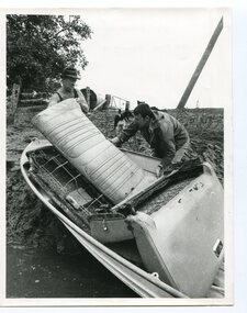
... This series of photos documents some of the destruction from the January 1971 flood at Orbost. This flood was a record Snowy River flood and isolated the district through road and bridge destruction. ...Inscription on back: 1971 FLOOD CLEANING UP. ...2733.1 1971 FLOOD. 2733.2 1971 FLOOD. 2733.3 1971 FLOOD. 2733.4 FLOOD MARKER AT ORBOST BUTTER FACTORY. 2733.5 1971 FLOOD HIGHWAY AT SOUTHERN END OF TOWN. 2733.6 1971 FLOOD CLEANING UP. ...These photos are significant because they document aspects of the record 1971 flood at Orbost, and are of good quality. Orbost Snowy River 1971 flood 2733.1 1971 FLOOD. 2733.2 1971 FLOOD. 2733.3 1971 FLOOD. 2733.4 FLOOD MARKER AT ORBOST BUTTER FACTORY. 2733.5 1971 FLOOD HIGHWAY AT SOUTHERN END OF TOWN. 2733.6 1971 FLOOD CLEANING UP. ...This series of photos documents some of the destruction from the January 1971 flood at Orbost. This flood was a record Snowy River flood and isolated the district through road and bridge destruction. These photos are significant because they document aspects of the record 1971 flood at Orbost, and are of good quality. A series of b/w photos from the 1971 record flood in Orbost. 2733.1 A b/w aerial photograph of a farm house with debris around, cattle in the background. Inscription: 1971 FLOOD. 2733.2 A b/w photo of 2 people walking towards an upturned vehicle in floodwaters. Inscription: 1971 FLOOD. 2733.3 A b/w photo taken at night time. Five people beside and climbing on a tree which has been uprooted, with water flowing underneath. Inscription: 1971 FLOOD. 2733.4 A b/w photo of a man standing in doorway of the old pumphouse for the Butter Factory. He is leaning out of the doorway and pointing to a mark on the wall (presumably the height of the 1971 flood). Inscription: FLOOD MARKER AT ORBOST BUTTER FACTORY. 2733.5 A b/w photo of a man and woman walking on a road towards a section of the road which has been broken-up by a flood waters. Inscription: 1971 FLOOD HIGHWAY AT SOUTHERN END OF TOWN. 2733.6 A b/w photo of two men with a boat hauled up on an eroded bank. They appear to be loading or unloading car seats. Inscription on back: 1971 FLOOD CLEANING UP. 2733.1 1971 FLOOD. 2733.2 1971 FLOOD. 2733.3 1971 FLOOD. 2733.4 FLOOD MARKER AT ORBOST BUTTER FACTORY. 2733.5 1971 FLOOD HIGHWAY AT SOUTHERN END OF TOWN. 2733.6 1971 FLOOD CLEANING UP. orbost, snowy river, 1971 flood -
 Eltham District Historical Society Inc
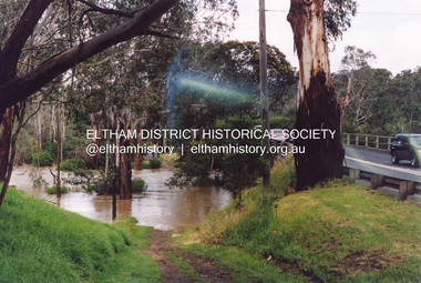
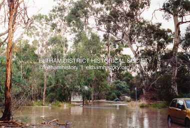
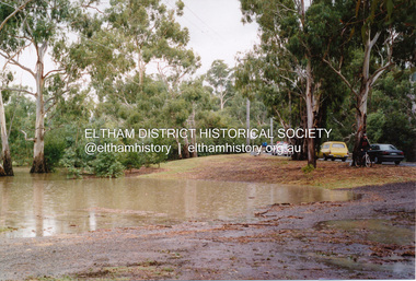
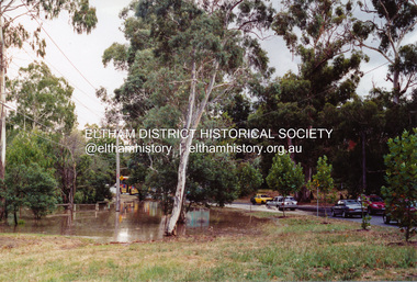
Photograph, Flooding of Diamond Creek at Lower Eltham Main Road bridge, Nov 2004, 2004
... Flooding of Diamond Creek at Lower Eltham Main Road bridge, Nov 2004...Two colour photographs of the flooded Diamond Creek at the Lower Eltham Main Road bridge in Nov 2004...Eltham District Historical Society Inc 728 Main Rd Eltham melbourne eltham main road bridges diamond creek floods Two colour photographs of the flooded Diamond Creek at the Lower Eltham Main Road bridge in Nov 2004 Flooding of Diamond Creek at Lower Eltham Main Road bridge, Nov 2004 Photograph Photograph ...Two colour photographs of the flooded Diamond Creek at the Lower Eltham Main Road bridge in Nov 2004eltham, main road, bridges, diamond creek, floods -
 Eltham District Historical Society Inc
Photograph, Flooding of Diamond Creek at Lower Eltham Main Road bridge, Nov 2004, 2004
... Flooding of Diamond Creek at Lower Eltham Main Road bridge, Nov 2004...Two colour photographs of the flooded Diamond Creek at the Lower Eltham Main Road bridge in Nov 2004...Eltham District Historical Society Inc 728 Main Rd Eltham melbourne eltham main road bridges diamond creek floods Two colour photographs of the flooded Diamond Creek at the Lower Eltham Main Road bridge in Nov 2004 Flooding of Diamond Creek at Lower Eltham Main Road bridge, Nov 2004 Photograph Photograph ...Two colour photographs of the flooded Diamond Creek at the Lower Eltham Main Road bridge in Nov 2004eltham, main road, bridges, diamond creek, floods -
 Ringwood and District Historical Society
Photograph, Ringwood Bowling Club- Flooding of greens, 1989
... Ringwood Bowling Club- Flooding of greens, 1989....Photograph shows No1 green when the flood had dropped by a foot or so....Photograph shows No1 green when the flood had dropped by a foot or so. Colour photograph Ringwood Bowling Club- Flooding of greens, 1989. ...Colour photographPhotograph was taken off the video shots taken by Jack Shandley. The flooding occurred on 10th April, 1989, when four inches of rain fell in 1½ hours. Photograph shows No1 green when the flood had dropped by a foot or so. -
 Croydon Conservation Society Inc.
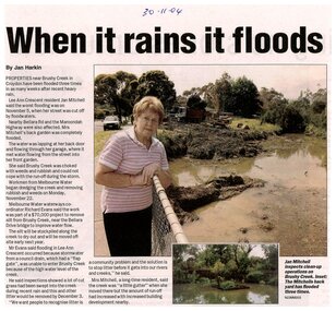
Newspaper, Article on the flooding of Brushy Creek Croydon dated 30.11.2004
... Article on the flooding of Brushy Creek Croydon dated 30.11.2004...Digitised newspaper article dated 30/11/2004, on the flooding of Brushy Creek Croydon at Lee Ann Crescent Croydon...Croydon melbourne Handwritten inscription on top of article: 30-11-04 Digitised newspaper article dated 30/11/2004, on the flooding of Brushy Creek Croydon at Lee Ann Crescent Croydon Article on the flooding of Brushy Creek Croydon dated 30.11.2004 Newspaper ...Digitised newspaper article dated 30/11/2004, on the flooding of Brushy Creek Croydon at Lee Ann Crescent CroydonHandwritten inscription on top of article: 30-11-04 -
 Charlton Golden Grains Museum Inc
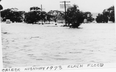
Photograph, B/W photograph 1973 Flash Flood on Calder Highway
... B/W photograph 1973 Flash Flood on Calder Highway...1973 Flash Flood on Calder Highway...Unframed B/W photograph 1973 Flash Flood on Calder Highway...Flood Calder Highway, Flash flood...Charlton Golden Grains Museum Inc 1 High Street Charlton goldfields 1973 Flash Flood on Calder Highway Charlton Calder Highway Floods Flood Calder Highway, Flash flood Unframed B/W photograph 1973 Flash Flood on Calder Highway B/W photograph 1973 Flash Flood on Calder Highway Photograph Photograph ...1973 Flash Flood on Calder HighwayUnframed B/W photograph 1973 Flash Flood on Calder HighwayFlood Calder Highway, Flash floodcharlton, calder highway, floods -
Whitehorse Historical Society Inc.
Article, Basin not the answer, claims flooding victim, 1993
... Basin not the answer, claims flooding victim...A retarding basin in Scott Street, Vermont is proposed to prevent flooding in Barbara Street, but former resident, Ms Daly is sceptical of its efficiency....Basin not the answer, claims flooding victim Article Article ...A retarding basin in Scott Street, Vermont is proposed to prevent flooding in Barbara Street, but former resident, Ms Daly is sceptical of its efficiency.A retarding basin in Scott Street, Vermont is proposed to prevent flooding in Barbara Street, but former resident, Ms Daly is sceptical of its efficiency.A retarding basin in Scott Street, Vermont is proposed to prevent flooding in Barbara Street, but former resident, Ms Daly is sceptical of its efficiency.city of nunawading., barbara street, vermont, scott street, vermont, daly, belinda, ward, kelvin -
 Eltham District Historical Society Inc
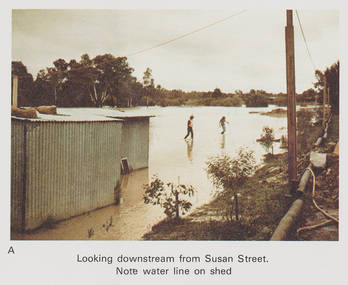
Work on paper (Sub-Item) - Photograph, Flooding, looking downstream from Susan Street, Eltham 8 April 1977
... Flooding, looking downstream from Susan Street, Eltham 8 April 1977......flooding...Note water line on shed flood diamond creek flooding Susan Street Image printed on A4 page from 04997 Diamond Creek Basin Study, 1980 Flooding, looking downstream from Susan Street, Eltham 8 April 1977 Work on paper Photograph ...Colour photograph. Looking downstream from Susan Street, Eltham , 8 April 1977. Note water line on shed flood, diamond creek, flooding, susan street -
 Kew Historical Society Inc
Photograph, Willsmere Bridge, 1934
... ...flood...The Moorings was almost washed away in the 1916 floods, and in 1934 almost totally submerged when the Yarra River rose 26 feet in 14 hours. ...A view of flooded areas in North Kew in the flood of 1934....Chipperfields. 1934 flood...Chipperfields. 1934 flood A view of flooded areas in North Kew in the flood of 1934. ...Several boathouses were built in Kew and Fairfield in the late 19th and early 20th centuries. They included Chipperfield’s ‘Moorings’ and floating pontoon. The substantial two-storey house was named the Moorings, and incorporated an upper storey residence. The Moorings was almost washed away in the 1916 floods, and in 1934 almost totally submerged when the Yarra River rose 26 feet in 14 hours. Following the 1934 flood, the house was restored. The floating pontoon, sometimes referred to as a ‘kiosk’ or ‘canteen’, was used to store canoes. Both were removed in 1972 for the construction of the Eastern Freeway.This work forms part of the collection assembled by the historian Dorothy Rogers, that was donated to the Kew Historical Society by her son John Rogers in 2015. The manuscripts, photographs, maps, and documents were sourced by her from both family and local collections or produced as references for her print publications. Many were directly used by Rogers in writing ‘Lovely Old Homes of Kew’ (1961) and 'A History of Kew' (1973), or the numerous articles on local history that she produced for suburban newspapers. Most of the photographs in the collection include detailed annotations in her hand. The Rogers Collection provides a comprehensive insight into the working habits of a historian in the 1960s and 1970s. Together it forms the largest privately-donated collection within the archives of the Kew Historical Society.A view of flooded areas in North Kew in the flood of 1934.Willsmere Bridge. Chipperfields. 1934 floodwillsmere, flood, yarra flood, chipperfields, chipperfields boathouse, north kew -
 Eltham District Historical Society Inc
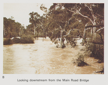
Work on paper (Sub-Item) - Photograph, Flooding, looking downstream from Main Road Bridge, Eltham 8 April 1977
... Flooding, looking downstream from Main Road Bridge, Eltham 8 April 1977......flooding...Looking downstream on the Diamond Creek from Main Road Bridge, Eltham , 8 April 1977. flood diamond creek flooding Main road Eltham Image printed on A4 page from 04997 Diamond Creek Basin Study, 1980 Flooding, looking downstream from Main Road Bridge, Eltham 8 April 1977 Work on paper Photograph ...Colour photograph. Looking downstream on the Diamond Creek from Main Road Bridge, Eltham , 8 April 1977. flood, diamond creek, flooding, main road, eltham -
 Ringwood and District Historical Society
Photograph, Ringwood Bowling Club- Flooding of greens, 1989
... Ringwood Bowling Club- Flooding of greens, 1989....Photograph was taken off the video shots taken by Jack Shandley. The flooding occurred on 10th April, 1989, when four inches of rain fell in 1½ hours....Colour photograph Ringwood Bowling Club- Flooding of greens, 1989. Photograph ...Colour photographPhotograph was taken off the video shots taken by Jack Shandley. The flooding occurred on 10th April, 1989, when four inches of rain fell in 1½ hours. -
 Eltham District Historical Society Inc
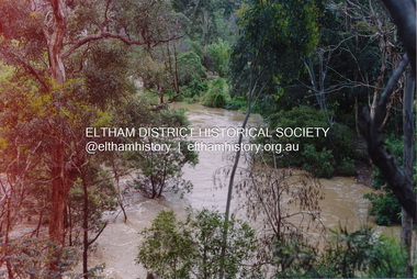
Photograph, Flooding of Diamond Creek at Lower Eltham, Feb 2005, 2005
... Flooding of Diamond Creek at Lower Eltham, Feb 2005...Three colour photographs of the flooded Diamond Creek showing Main Road floodwater below Dalton Street (Eltham Primary) school, west side of Diamond Creek near flower stall and Wingrove Park, Feb 2005...Eltham District Historical Society Inc 728 Main Rd Eltham melbourne eltham main road diamond creek floods dalton street wingrove park Three colour photographs of the flooded Diamond Creek showing Main Road floodwater below Dalton Street (Eltham Primary) school, west side of Diamond Creek near flower stall and Wingrove Park, Feb 2005 Flooding of Diamond Creek at Lower Eltham, Feb 2005 Photograph Photograph ...Three colour photographs of the flooded Diamond Creek showing Main Road floodwater below Dalton Street (Eltham Primary) school, west side of Diamond Creek near flower stall and Wingrove Park, Feb 2005eltham, main road, diamond creek, floods, dalton street, wingrove park -
 Eltham District Historical Society Inc
Photograph, Flooding of Diamond Creek at Lower Eltham, Feb 2005, 2005
... Flooding of Diamond Creek at Lower Eltham, Feb 2005...Three colour photographs of the flooded Diamond Creek showing Main Road floodwater below Dalton Street (Eltham Primary) school, west side of Diamond Creek near flower stall and Wingrove Park, Feb 2005...Eltham District Historical Society Inc 728 Main Rd Eltham melbourne eltham main road diamond creek floods dalton street wingrove park Three colour photographs of the flooded Diamond Creek showing Main Road floodwater below Dalton Street (Eltham Primary) school, west side of Diamond Creek near flower stall and Wingrove Park, Feb 2005 Flooding of Diamond Creek at Lower Eltham, Feb 2005 Photograph Photograph ...Three colour photographs of the flooded Diamond Creek showing Main Road floodwater below Dalton Street (Eltham Primary) school, west side of Diamond Creek near flower stall and Wingrove Park, Feb 2005eltham, main road, diamond creek, floods, dalton street, wingrove park -
 Greensborough Historical Society
Newspaper clipping, Diamond Valley Leader, Drainage calls come flooding in, and, Library heeds call of the e-book, 20/01/2012
... Drainage calls come flooding in, and, Library heeds call of the e-book....Article 1 "Drainage calls come flooding in" deals with the drainage problems throughout Banyule in the aftermath of the Christmas Day 2011 floods. ...Drainage calls come flooding in, and, Library heeds call of the e-book. ...Article 1 "Drainage calls come flooding in" deals with the drainage problems throughout Banyule in the aftermath of the Christmas Day 2011 floods. Article 2 "Library heeds the call of the e-book" discusses some of the digital technology available at Yarra Plenty Regional Library.Newspaper clipping. 2 articles, one with colout image.DV Leader 20/1/2012christmas day 2011, floods, drains, tom melican, yarra plenty regional library, ebooks, digital technology., banyule city council -
 Heidelberg Golf Club
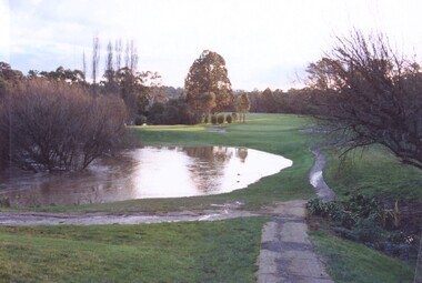
Photograph, Plenty River flooding across 2nd fairway, July 1997, July 1997
... Plenty River flooding across 2nd fairway, July 1997...Plenty River flooding across 2nd fairway, July 1997, Heidelberg Golf Club...Heidelberg Golf Club 8 Main Road Lower Plenty 3093 Plenty River flooding across 2nd fairway, July 1997, Heidelberg Golf Club Heidelberg Golf Club 2nd fairway Colour photograph of a golf course Plenty River flooding across 2nd fairway, July 1997 Photograph Photograph ...Plenty River flooding across 2nd fairway, July 1997, Heidelberg Golf ClubColour photograph of a golf courseheidelberg golf club, 2nd fairway -
 Ringwood and District Historical Society
Photograph, Ringwood Bowling Club- Flooding of greens, 1989
... Ringwood Bowling Club- Flooding of greens, 1989....Photograph was taken off the video shots taken by Jack Shandley. The flooding occurred on 10th April, 1989, when four inches of rain fell in 1½ hours. ...Colour photograph Ringwood Bowling Club- Flooding of greens, 1989. Photograph ...Colour photographPhotograph was taken off the video shots taken by Jack Shandley. The flooding occurred on 10th April, 1989, when four inches of rain fell in 1½ hours. Photograph shows the height of the water in relation to the top of the Mullum Creek viaduct.