Showing 108 items matching "floods (melbourne) 1934"
-
 Kew Historical Society Inc
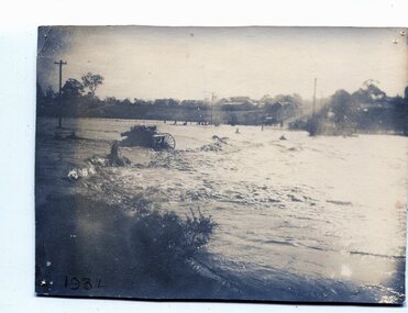
Photograph, Cattle in North Kew floods, 1934
... floods (melbourne) 1934...Together it forms the largest privately-donated collection within the archives of the Kew Historical Society. floods (melbourne) 1934 dorothy rogers Nth. Kew. 1934 Floods Photograph of floodwaters encroaching on farm land in North Kew in the flood of 1934. ...The year 1934 witnessed the greatest flooding of the Yarra River since settlement. This work forms part of the collection assembled by the historian Dorothy Rogers, that was donated to the Kew Historical Society by her son John Rogers in 2015. The manuscripts, photographs, maps, and documents were sourced by her from both family and local collections or produced as references for her print publications. Many were directly used by Rogers in writing ‘Lovely Old Homes of Kew’ (1961) and 'A History of Kew' (1973), or the numerous articles on local history that she produced for suburban newspapers. Most of the photographs in the collection include detailed annotations in her hand. The Rogers Collection provides a comprehensive insight into the working habits of a historian in the 1960s and 1970s. Together it forms the largest privately-donated collection within the archives of the Kew Historical Society.Photograph of floodwaters encroaching on farm land in North Kew in the flood of 1934.Nth. Kew. 1934 Floodsfloods (melbourne) 1934, dorothy rogers -
 Kew Historical Society Inc
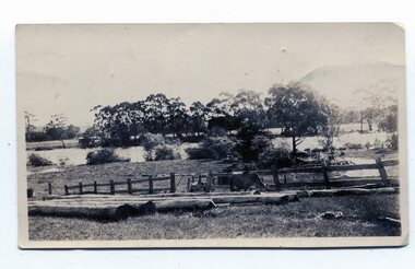
Photograph, Floods in North Kew, 1934
... The great flood of 1934 in Melbourne was one of the most devastating floods since records began. ...Kew Historical Society Inc Kew Court House 188 High Street Kew melbourne The great flood of 1934 in Melbourne was one of the most devastating floods since records began. ...The great flood of 1934 in Melbourne was one of the most devastating floods since records began. The floods affected all of Melbourne, including Kew.Locally significant photographs of the impact of flooding in Kew in 1934Floods in North Kew, 1934. Flood near Lagoon (Billabong?) Willsmere Road, North Kew.floods (kew) 1934, yarra river -
 Eltham District Historical Society Inc
Photograph (Item) - Print, Elizabeth Simkin, Craft Galore, 1988
... Eltham District Historical Society Inc 728 Main Rd Eltham melbourne Riverclay Craft Gallery, 573 Main Road, Eltham Riverclay was loacted along with Ansell and Muirs Chicken shop opposite El;tham Lower Park. The building has since been demolished as it lay within the 1934 flood plain limits. ...Riverclay Craft Gallery, 573 Main Road, Eltham Riverclay was loacted along with Ansell and Muirs Chicken shop opposite El;tham Lower Park. The building has since been demolished as it lay within the 1934 flood plain limits. Elizabeth Simkin 1988 Entrant No. 149 Ref: Series 34, Items 39, 111-113 SHIRE OF ELTHAM COMMUNITY PHOTOGRAPHIC SURVEY Photography is an artform which many of us practice, sometimes purely for artistic pursuit, sometimes to record the people and events in our lives. In 1988, as part of a local Bicentennial project, the Shire of Eltham conducted the Eltham Community Photographic Survey. Up to 100 entries were to be selected by a panel of photographers for entry into the Eltham Photographic Survey Exhibition. Entries had to be submitted by May 13, 1988. Entrants whose images were selected for the exhibition were contacted and requested to further submit an entry form providing entrant’s name, area of residence, age, and proposed captions. These details were then used to produce labels for the exhibition mounts. Where negatives had not been supplied, these were requested to support the display of printed enlargements mounted on 10” x 8” cardboard. The mounted prints were made available post exhibition for sale at $8.50 each for colour prints and $7.00 for B&W prints. Residents in the Shire were invited to collect a free roll of film and take a photograph of what they either liked or did not like about the area. A total of 160 entrants submitted multiple entries for the exhibition. Of those selected for exhibition, entrants ranged in age from 9 to 70 years. All custom colour and black and white printing for the exhibition was completed by Wattle Studios of Eltham. The Eltham Photographic Survey was jointly auspiced by the Shire of Eltham and Wattle Studios, of 953 Main Road, Eltham. The project was greatly assisted by: • David McRitchie, Media Studies Lecturer Victoria College, Rusden Campus. • Ian and Annette Toohill of Wattle Studios • Tracy Naughton, Eltham Community Arts Officer • Neville Emerson Pty. Ltd. • Superior Press, Eltham • Kodak Australasia Pty. Ltd. • Agfa Gevaert Ltd. • Townsend Colourtech Pty. Ltd. • The Australian Bicentennial Authority • Eleanor Bowers, Secretary, Eltham Arts Council The exhibition was placed on display in the Woolworths Arcade, Eltham between Monday June 6th and Saturday June 11, 1988. It was also intended to hold the exhibition at a venue in the Shire’s North Riding from Monday, June 20 to Friday June 24. It was then displayed at the Were Street Theatre, Montmorency from Friday, June 24 to Thursday, July 7. Series 34: Eltham Community Photographic Survey 1988 - Prints & Documentation Series consists of 117 photographs of Shire scenes taken by members of the community. Items I - 41 are larger photographs mounted on card, which were exhibited. Items 42 - 117 are unmounted copies, alternative takes and other entries. Corresponding negatives contained in Series 35: Eltham Community Photographic Survey 1988 – Negatives which consists of 267 colour and B&W negatives and one colour slide of Shire scenes taken by members of the community. The negatives are arranged by the entrant number of the photographer. The Eltham Community Photographic Survey collection is significant to the local community as it was curated by the local community - ordinary people of all ages - representing what they liked and did not like in the area where they lived. It represents an unfiltered representation of the Shire of Eltham as it was in 1988. It also represents one of many projects as part of the national programme of events and celebrations to commemorate the bicentenary. It is a time capsule of life in the 1980s of this urban and rural municipality in Melbourne's north. Front: Entrant No. and name on printed label Rear: Entrant No., name and address on printed label; also 'Series 34' and the 'Item No.' in pencilshire of eltham archives, bicentennial project, eltham, eltham community photographic survey, eltham photographic survey exhibition, series 34, series 35, elizabeth simkin, film - kodak ga 100 5095, riverclay craft gallery, scan - 35mm negative -
 Eltham District Historical Society Inc
Photograph (Item) - Print, Elizabeth Simkin, Untitled (Cane baskets), 1988
... Eltham District Historical Society Inc 728 Main Rd Eltham melbourne Riverclay Craft Gallery, 573 Main Road, Eltham Riverclay was located along with Ansell and Muir's Chicken shop opposite Eltham Lower Park. The building has since been demolished as it lay within the 1934 flood plain limits Elizabeth Simkin 1988 Entrant No. 149 Ref: Series 34, Items 39, 111-113 The photographer noted that in a sad indictment of the local community, this German Shepherd dog and another had been abandoned by their owners to scavenge through the bins and chase the drunks around the lake at dawn. ...Riverclay Craft Gallery, 573 Main Road, Eltham Riverclay was located along with Ansell and Muir's Chicken shop opposite Eltham Lower Park. The building has since been demolished as it lay within the 1934 flood plain limits Elizabeth Simkin 1988 Entrant No. 149 Ref: Series 34, Items 39, 111-113 The photographer noted that in a sad indictment of the local community, this German Shepherd dog and another had been abandoned by their owners to scavenge through the bins and chase the drunks around the lake at dawn. Both dogs were impounded and the owners never claimed them. As a consequence they were eventually both put down. The photographer noted that in a sad indictment of the local community, this German Shepherd dog and another had been abandoned by their owners to scavenge through the bins and chase the drunks around the lake at dawn. Both dogs were impounded and the owners never claimed them. As a consequence they were eventually both put down. SHIRE OF ELTHAM COMMUNITY PHOTOGRAPHIC SURVEY Photography is an artform which many of us practice, sometimes purely for artistic pursuit, sometimes to record the people and events in our lives. In 1988, as part of a local Bicentennial project, the Shire of Eltham conducted the Eltham Community Photographic Survey. Up to 100 entries were to be selected by a panel of photographers for entry into the Eltham Photographic Survey Exhibition. Entries had to be submitted by May 13, 1988. Entrants whose images were selected for the exhibition were contacted and requested to further submit an entry form providing entrant’s name, area of residence, age, and proposed captions. These details were then used to produce labels for the exhibition mounts. Where negatives had not been supplied, these were requested to support the display of printed enlargements mounted on 10” x 8” cardboard. The mounted prints were made available post exhibition for sale at $8.50 each for colour prints and $7.00 for B&W prints. Residents in the Shire were invited to collect a free roll of film and take a photograph of what they either liked or did not like about the area. A total of 160 entrants submitted multiple entries for the exhibition. Of those selected for exhibition, entrants ranged in age from 9 to 70 years. All custom colour and black and white printing for the exhibition was completed by Wattle Studios of Eltham. The Eltham Photographic Survey was jointly auspiced by the Shire of Eltham and Wattle Studios, of 953 Main Road, Eltham. The project was greatly assisted by: • David McRitchie, Media Studies Lecturer Victoria College, Rusden Campus. • Ian and Annette Toohill of Wattle Studios • Tracy Naughton, Eltham Community Arts Officer • Neville Emerson Pty. Ltd. • Superior Press, Eltham • Kodak Australasia Pty. Ltd. • Agfa Gevaert Ltd. • Townsend Colourtech Pty. Ltd. • The Australian Bicentennial Authority • Eleanor Bowers, Secretary, Eltham Arts Council The exhibition was placed on display in the Woolworths Arcade, Eltham between Monday June 6th and Saturday June 11, 1988. It was also intended to hold the exhibition at a venue in the Shire’s North Riding from Monday, June 20 to Friday June 24. It was then displayed at the Were Street Theatre, Montmorency from Friday, June 24 to Thursday, July 7. Series 34: Eltham Community Photographic Survey 1988 - Prints & Documentation Series consists of 117 photographs of Shire scenes taken by members of the community. Items I - 41 are larger photographs mounted on card, which were exhibited. Items 42 - 117 are unmounted copies, alternative takes and other entries. Corresponding negatives contained in Series 35: Eltham Community Photographic Survey 1988 – Negatives which consists of 267 colour and B&W negatives and one colour slide of Shire scenes taken by members of the community. The negatives are arranged by the entrant number of the photographer. The Eltham Community Photographic Survey collection is significant to the local community as it was curated by the local community - ordinary people of all ages - representing what they liked and did not like in the area where they lived. It represents an unfiltered representation of the Shire of Eltham as it was in 1988. It also represents one of many projects as part of the national programme of events and celebrations to commemorate the bicentenary. It is a time capsule of life in the 1980s of this urban and rural municipality in Melbourne's north. Rear: Entrant No., name and address in blue ink; also 'Series 34' and the 'Item No.' in orange inkshire of eltham archives, bicentennial project, eltham, eltham community photographic survey, series 34, series 35, elizabeth simkin, film - kodak ga 100 5095, riverclay craft gallery, scan - 35mm negative -
 Eltham District Historical Society Inc
Photograph (Item) - Negative, Elizabeth Simkin, Riverclay Craft Gallery, 573 Main Road, Eltham, 1988
... Eltham District Historical Society Inc 728 Main Rd Eltham melbourne Riverclay was located along with Ansell and Muirs Chicken shop opposite El;tham Lower Park. The building has since been demolished as it lay within the 1934 flood plain limits. ...Riverclay was located along with Ansell and Muirs Chicken shop opposite El;tham Lower Park. The building has since been demolished as it lay within the 1934 flood plain limits. Elizabeth Simkin 1988 Entrant No. 149 Ref: Series 34, Items 39, 111-113 The images in this record were not selected for inclusion. SHIRE OF ELTHAM COMMUNITY PHOTOGRAPHIC SURVEY Photography is an artform which many of us practice, sometimes purely for artistic pursuit, sometimes to record the people and events in our lives. In 1988, as part of a local Bicentennial project, the Shire of Eltham conducted the Eltham Community Photographic Survey. Up to 100 entries were to be selected by a panel of photographers for entry into the Eltham Photographic Survey Exhibition. Entries had to be submitted by May 13, 1988. Entrants whose images were selected for the exhibition were contacted and requested to further submit an entry form providing entrant’s name, area of residence, age, and proposed captions. These details were then used to produce labels for the exhibition mounts. Where negatives had not been supplied, these were requested to support the display of printed enlargements mounted on 10” x 8” cardboard. The mounted prints were made available post exhibition for sale at $8.50 each for colour prints and $7.00 for B&W prints. Residents in the Shire were invited to collect a free roll of film and take a photograph of what they either liked or did not like about the area. A total of 160 entrants submitted multiple entries for the exhibition. Of those selected for exhibition, entrants ranged in age from 9 to 70 years. All custom colour and black and white printing for the exhibition was completed by Wattle Studios of Eltham. The Eltham Photographic Survey was jointly auspiced by the Shire of Eltham and Wattle Studios, of 953 Main Road, Eltham. The project was greatly assisted by: • David McRitchie, Media Studies Lecturer Victoria College, Rusden Campus. • Ian and Annette Toohill of Wattle Studios • Tracy Naughton, Eltham Community Arts Officer • Neville Emerson Pty. Ltd. • Superior Press, Eltham • Kodak Australasia Pty. Ltd. • Agfa Gevaert Ltd. • Townsend Colourtech Pty. Ltd. • The Australian Bicentennial Authority • Eleanor Bowers, Secretary, Eltham Arts Council The exhibition was placed on display in the Woolworths Arcade, Eltham between Monday June 6th and Saturday June 11, 1988. It was also intended to hold the exhibition at a venue in the Shire’s North Riding from Monday, June 20 to Friday June 24. It was then displayed at the Were Street Theatre, Montmorency from Friday, June 24 to Thursday, July 7. Series 34: Eltham Community Photographic Survey 1988 - Prints & Documentation Series consists of 117 photographs of Shire scenes taken by members of the community. Items I - 41 are larger photographs mounted on card, which were exhibited. Items 42 - 117 are unmounted copies, alternative takes and other entries. Corresponding negatives contained in Series 35: Eltham Community Photographic Survey 1988 – Negatives which coThe Eltham Community Photographic Survey collection is significant to the local community as it was curated by the local community - ordinary people of all ages - representing what they liked and did not like in the area where they lived. It represents an unfiltered representation of the Shire of Eltham as it was in 1988. It also represents one of many projects as part of the national programme of events and celebrations to commemorate the bicentenary. It is a time capsule of life in the 1980s of this urban and rural municipality in Melbourne's north. shire of eltham archives, bicentennial project, eltham community photographic survey, film - kodak ga 100 5095, elizabeth simkin, eltham, scan - 35mm negative, series 35, cane baskets, riverclay craft gallery -
 Eltham District Historical Society Inc
Film - Video (DVD), Melbourne and Metropolitan Board of Works, Yarra River Conference Proceedings; a Board of Works centenary event, 13-16 April 1991
... to Utility Early navigators of the Yarra River; developing the port of Melbourne; the gold rush and its effect on the new colony; punts and bridges; water supply; pollution of the Yarra; the discovery of gold and early settlement of the Yarra valley; floods of 1839 and 1863. 1863-1891 Formation of the Harbour Trust; Coode Canal; pollution of the Yarra by industry; aborigines, gold miners, timber getters in the Upper Yarra areas; bridges; the flood of 1891. Tape 2 ( 1 1/2 hours) 1892-1934...to Utility Early navigators of the Yarra River; developing the port of Melbourne; the gold rush and its effect on the new colony; punts and bridges; water supply; pollution of the Yarra; the discovery of gold and early settlement of the Yarra valley; floods of 1839 and 1863. 1863-1891 Formation of the Harbour Trust; Coode Canal; pollution of the Yarra by industry; aborigines, gold miners, timber getters in the Upper Yarra areas; bridges; the flood of 1891. Tape 2 ( 1 1/2 hours) 1892-1934 ...Yarra River Conference History Segment [Noted on VHS tape jackets "Due to unavoidable circumstances, the quality of these tapes in some setions is less than desired."] The Yarra River Conference, organised by the Board of Works as part of the Centenary Celebrations, was held in the Board's Head Office Theatrette from 13-16 April, 1991. A segment of the Conference focussed on the role that the Yarra River has played in relation to the historical development of Melbourne. Conceived and presented by a group of prominent historians as a chronological 'trip down the river in time', and profusely illustrated with slides, this segment traced the various impacts that urban and rural growth, development of marine commerce, recreational uses, and environmental problems have had on the Yarra during a century and a half of European occupation. As no formal written paper of this combined presentation is available, these two video-tapes provide a record for anyone who has an interest in tis fascinating aspect of the Yarra's history. The speakers who combined to present this segment are identified on the cover of Tape 2. Tape 1 (2 hours) 1838-1863 Deputy ?? to Utility Early navigators of the Yarra River; developing the port of Melbourne; the gold rush and its effect on the new colony; punts and bridges; water supply; pollution of the Yarra; the discovery of gold and early settlement of the Yarra valley; floods of 1839 and 1863. 1863-1891 Formation of the Harbour Trust; Coode Canal; pollution of the Yarra by industry; aborigines, gold miners, timber getters in the Upper Yarra areas; bridges; the flood of 1891. Tape 2 ( 1 1/2 hours) 1892-1934: People Begin to See Beauty and Romance to the River Henley-on-Yarra; realignment of the Yarra; MMBW is responsible for a sewerage system; new docks to cope with increased overseas trade; development of recreational parks; new reservoirs; timber production and timber tramways; bushfire; flood of 1934. 1935-1970: The River is Neglected Still, Except When it Proves Useful Bushfirs of 1939; the end of many sawmills; birth of tourism; increased interest in conservation and preservation of land for open space; further augmentation of water supply system; birth of containerisation changes the port; environmental concerns gain momentum. Speakers Dr Tony Dingle *, Department of Economic History, Monash University Dr Carolyn Rasmussen *, History Consultant Prof. Graeme Davison, History Department, Monash University Mr. Tom Griffiths, Lecturer in Public History, Monash Uiversity Mr. Patrick Miller, History Consultant Mr. Colin Jones, Author and Historian * Co-authors of the Board's history, 'Vital Connections'.video recording, yarra river, conference proceedings -
 Eltham District Historical Society Inc
Photograph, M. North, Main Road, Eltham near Fitzsimons Lane Roundabout, Dec 1985, 1/12/85
... Eltham District Historical Society Inc 728 Main Rd Eltham melbourne main road eltham eltham south fitzsimons lane round about falkiner street Noted on 463B 'See 1934 small black and white snap of flooded bridge and the same two shops. ...Two colour photographs of Main Road, ElthamSouth between Falkiner Street and Bolton Street at the roundabout of Fitzsimons Lane, Eltham, Dec 1985Noted on 463B 'See 1934 small black and white snap of flooded bridge and the same two shops. This snap taken from same location, Dec 1985. Old Eltham Park on right of photo The two shops at left (Ansel and Muir) Road ahead crosses new bridge over the Diamond Creek, Eltham Main Road now dual highway, through Lower Plenty to this bridge'main road, eltham, eltham south, fitzsimons lane, round about, falkiner street -
 Eltham District Historical Society Inc
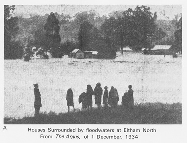
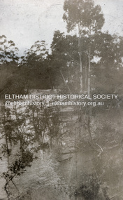
Work on paper (Sub-Item) - Photograph, Houses surrounded by floodwaters at Eltham North
... melbourne "The house (centre) at North Eltham in which Mr. and Mrs. William Frizell, an elderly couple, were marooned by flood waters. When this photograph was taken late yesterday afternoon the couple were still inside the house, and through a ventilator they had stuck a red flag which they waved from time to time. The house on the left belongs to Mr. Leads, who also was marooned." - The Argus 1 December 1934 ..."The house (centre) at North Eltham in which Mr. and Mrs. William Frizell, an elderly couple, were marooned by flood waters. When this photograph was taken late yesterday afternoon the couple were still inside the house, and through a ventilator they had stuck a red flag which they waved from time to time. The house on the left belongs to Mr. Leads, who also was marooned." - The Argus 1 December 1934. John William Frizell, painter and his wife Sarah Jane are registered at Glen Park, Eltham in the 1924 Electorial Roll This was most probably the Diamond Creek in flood. In 1934 extensive flooding of the Yarra River and Diamond Creek sets new records for flood plain level (via Chronology of Eltham, EDHS) flood, frizell, leads, argus, glen park, eltham north, flooding, marooned, diamond creek -
 Eltham District Historical Society Inc
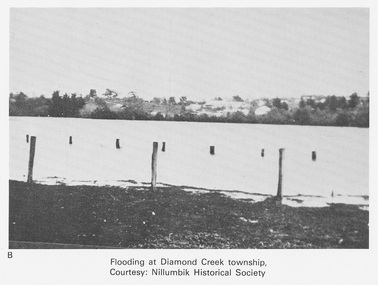
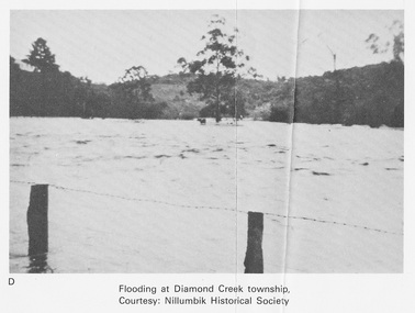
Work on paper (Sub-Item) - Photograph, Flooding at Diamond Creek Township
... Eltham District Historical Society Inc 728 Main Rd Eltham melbourne Black and white photograph of the Diamond Creek in flood at Diamond Creek township in 1934. ...Black and white photograph of the Diamond Creek in flood at Diamond Creek township in 1934. In 1934 extensive flooding of the Yarra River and Diamond Creek set new records for flood plain level (Eltham Chronology EDHS) Nillumbik Historical Society collectionflood, diamond creek, flooding, nillumbik historical society -
 Eltham District Historical Society Inc
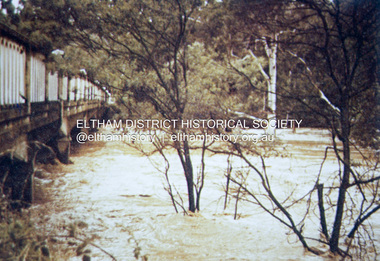
Negative - Photograph, Floodwaters, Diamond Creek, Eltham, 1934
... Eltham District Historical Society Inc 728 Main Rd Eltham melbourne The Diamond Creek in flood near the Main Road bridge at Eltham, Victoria. The Yarra also was in flood. In early December 1934 ...The Diamond Creek in flood near the Main Road bridge at Eltham, Victoria. The Yarra also was in flood. In early December 1934 the "Greatest flood in the history of the Yarra" occured, according to The Argus newspaper. Bridges and houses were swept away with hundreds of people left homeless across the state. The historic 1934 flood of the Diamond Creek and Yarra River set the criteria for future planning with respect to flood water rise. Noted on reverse of print - Copied by Hugh Fisher, 82 Lygon St., BrunswickThis photo forms part of a collection of photographs gathered by the Shire of Eltham for their centenary project book,"Pioneers and Painters: 100 years of the Shire of Eltham" by Alan Marshall (1971). The collection of over 500 images is held in partnership between Eltham District Historical Society and Yarra Plenty Regional Library (Eltham Library) and is now formally known as the 'The Shire of Eltham Pioneers Photograph Collection.' It is significant in being the first community sourced collection representing the places and people of the Shire's first one hundred years.Digital image 4 x 5 inch B&W Neg (2 frames on one neg) Print 9 x 15.5 cmOn reverse of print - "Copied by Hugh Fisher, 82 Lygon St., Brunswick" (for Shire of Eltham)sepp, shire of eltham pioneers photograph collection, eltham, floods, 1934 flood, diamond creek (creek), floodwater -
 Eltham District Historical Society Inc
Slide - Photograph, 1934 flood, Eltham South, c.Sep. 1989
... Eltham District Historical Society Inc 728 Main Rd Eltham melbourne Part of a slide show presentation "Bridges & Waterways of the Shire" by Russell Yeoman to the 13 September 1989 Society meeting. The presentation included slides of historic photos from the Shire of Eltham Pioneers collections as well as several recent views. Eltham Diamond Creek (Creek) 1934 flood ...Part of a slide show presentation "Bridges & Waterways of the Shire" by Russell Yeoman to the 13 September 1989 Society meeting. The presentation included slides of historic photos from the Shire of Eltham Pioneers collections as well as several recent views.35mm colour positive transparency (1 of 33) Mount - Agfa CS System grey 8 dotsProcess Date Sep 1989eltham, diamond creek (creek), 1934 flood, eltham south, main road bridge -
 Eltham District Historical Society Inc
Document - Folder, McLean, 1984-1999
... (Carpenter family tree, Jade Carpenter) - Gwenneth Mae McLean born Feb 1928 Melbourne, died Jul 2017, Heyfield (Carpenter family tree, Ashleigh Carpenter via Ancestry only has 5 of the 6 girls – Edith not listed, possibly still living at the time o Dorothy Jean (1922-2012) o Edith (20 Dec 1922 - ) o Olive Isabel (1926-2002) o Gwenneth Mae (1928-2017) o Phoebe Lillian (1929-1999) o Gwladys Evelyn (1933-1986) - Family mentioned “Outstanding in Eltham's History” (1934, December 21). Advertiser (Hurstbridge, Vic. : 1922 - 1939), p. 1. Retrieved June 20, 2022, from http://nla.gov.au/nla.news-article56747552 1934 Flood ...References to McLean family, Hector John McLean and Louisa Frances (nee Green) and six daughters who lived in Eltham during the period 1930 to 1934 inclusive. Lived in the former Evelyn Hotel at the time it was destroyed by fire and being part of the Centenary Parade in 1934 where the family won the Group Section for their entry “Pioneers of Eltham” Reminiscences provided by Edith Jones (nee M1934 flood, ballroom, baptism, barber shop, bittern, boy scouts, bremner's flat, burgoyne's shop, cable tram, cemetery road, centenary celebrations, centenary parade, christening, coach house, collis grocery, dalton street, depression, dole, dorothy jean mclean, edith jones (nee mclean), eltham fire brigade, eltham high school, eltham higher elementary school, eltham lower park, eltham railway station, eltham state school no. 209, evelyn hotel, fire damage - buildings, flinders naval depot, fordham, gladys evelyn mclean, gold mining, gwenneth mae mclean, gwladys evelyn mclean, headmistress, hector john mclean, isherwood house and shop, louisa frances mclean (nee green), metery road, methodist church, miss finnin, miss grant cottage, motor bike races, mrs barrett, mrs bremner, mrs hurley, olive isabel mclean, parade, phoebe lillian mclean, picnic, pioneers of eltham, pitt street, research fire brigade, rev. r.g. arthur, shed, shops, st margarets church hall, st margaret's church, stables, state savings bank of victoria, susso books, todaro, vinnie willet, warrandyte bridge, warrandyte, wingrove park, yarra river -
 Eltham District Historical Society Inc
Photograph, Flood at Eltham, c.1924
... Eltham District Historical Society Inc 728 Main Rd Eltham melbourne Probably the 1924 flood which damaged the Main Road Bridge. Heather Cone and her mother Charlotte Helena Cone were still living in Eltham at that time. When the 1934 ...Probably the 1924 flood which damaged the Main Road Bridge. Heather Cone and her mother Charlotte Helena Cone were still living in Eltham at that time. When the 1934 record flood occured they had moved to Glen Iris. Pages from a scrapbook belonging to Heather Jenkins (nee Cone) who lived as a child in the Police Residence at 728 Main Road, Eltham in the 1920s.Heather Jenkins was the daughter of Constable John Thomas Cone, Badge #3935 served at Eltham Police Station 1 May 1911 to 9 July 1922.Glued on a brown paper scrapbook page (torn from scrapbook) with 8 black and white/sepia photos of varying sizes, 1 newspaper clipping and one greeting card with printed sketch and handwritten captions in ink. On back of page is 1 black and white photo and a large newspaper clipping.eltham, floods -
 Eltham District Historical Society Inc
Folder, Eltham Memories, 2001
... melbourne Written and transcribed by Peter Bassett-Smith. Extracts from letters to his mother 1934. Discusses his involement in a local play and other local observations in Eltham including recollections of the 1934 flood. harry gilham collection peter bassett-smith letters Floods HG Booklet 54 4 pages Eltham Memories Folder ...Written and transcribed by Peter Bassett-Smith. Extracts from letters to his mother 1934. Discusses his involement in a local play and other local observations in Eltham including recollections of the 1934 flood. 4 pagesHG Booklet 54harry gilham collection, peter bassett-smith, letters, floods -
 Eltham District Historical Society Inc
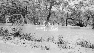
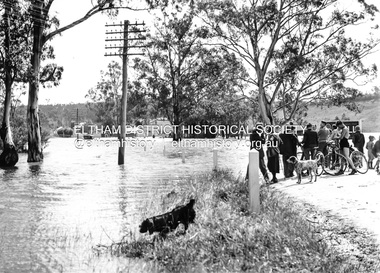
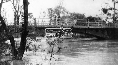
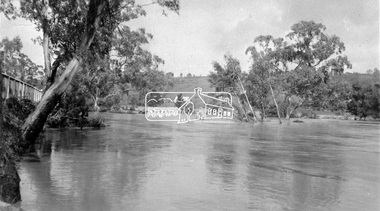
Photograph, Main Road, Eltham South, near Eltham Park, flooded by the Diamond Creek, 30 Nov. 1934
... melbourne Near Eltham Park (now known as Eltham Lower Park), floodwaters from the Diamond Creek cut off the Main road into Eltham at Bremner’s Flats (present day Wingrove Park). In the distance, left of centre, is Mr. Montieth's Ford Wagonette stranded in the floodwater near Wingrove Cottage. “On the Lower Eltham Reserve the water was nearly five feet deep across the reserve and over a mile along the road. All the week-end shops are surrounded. For over 40 years flood waters have not reached this unprecedented level.” - Advertiser, Friday November 30, 1934 ...Near Eltham Park (now known as Eltham Lower Park), floodwaters from the Diamond Creek cut off the Main road into Eltham at Bremner’s Flats (present day Wingrove Park). In the distance, left of centre, is Mr. Montieth's Ford Wagonette stranded in the floodwater near Wingrove Cottage. “On the Lower Eltham Reserve the water was nearly five feet deep across the reserve and over a mile along the road. All the week-end shops are surrounded. For over 40 years flood waters have not reached this unprecedented level.” - Advertiser, Friday November 30, 1934, p7 "Whilst we were at the shop a "tidal" wave occured . There used to be a Mr. Monteith who ran a Model T Ford bus from the Eltham Railway Station down the main street. The bus would hold seven, six seated in the back, 3 aside a seventh standing on the step on the middle of the back hanging on to two small hand rails. The bus was caught by the flood and was abandoned not far from our shop in the paddocks towards the Higher Elementary School. It was there for days and after the flood waters receded, Mr. Monteith, after removing all the mud and debris gave the engine one turn with the handle and it started first time! So the story goes! " (Doug Orford Reminiscences, 2004) The 1934 flood of the Diamond Creek and Yarra River is the highest recorded flooding in the district and set the standard for the current planning flood plain level.Black and white photograph showing the floodwater from Diamond Creek across Main Road in 1934. Left of centre shows Mr. Montieth's Ford Wagonette in the floodwater in the distancefloods, main road, eltham south, diamond creek (creek), wingrove cottage, wingrove park, bus services, bremner's flat, eltham park, ford wagonette, mr. montieth, floodwater, reminscences -
 Eltham District Historical Society Inc
Newsletter, Newsletter, No. 161 March 2005
... Eltham District Historical Society Inc 728 Main Rd Eltham melbourne Contents: • Next meeting, guest speaker; Peter Dougherty: History in a Word • Annual General Meeting • Peter Dougherty • February Meeting and the Flood Connection • Art Streams • The 1934 Floods at Eltham by Harold Bird • Nillumbik Combined History Groups • What Else? ...Contents: • Next meeting, guest speaker; Peter Dougherty: History in a Word • Annual General Meeting • Peter Dougherty • February Meeting and the Flood Connection • Art Streams • The 1934 Floods at Eltham by Harold Bird • Nillumbik Combined History Groups • What Else? The Shire of Eltham Historical Society was formed in October 1967. The first newsletter of the Society was issued May 1978 and has been published continuously ever since on a bi-monthly basis. With the cessation of the Shire of Eltham in late 1994, the Society's name was revised to Eltham District Historical Society and this name first appeared with issue No. 103, July 1995. The collection of the Society's newsletters provides a valuable resource on the history of the Society's activities, office bearers and committee members, guest speakers and subjects of historical interest pertinent to the former Shire of Eltham and the Eltham District.A4 photocopied newsletter distributed to membersnewsletter, eltham district historical society, shire of eltham historical society -
 Eltham District Historical Society Inc
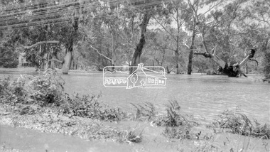
Negative - Photograph, Diamond Creek floodwater at Monash Bridge, Hurstbridge, Dec. 1934
... Eltham District Historical Society Inc 728 Main Rd Eltham melbourne The historic 1934 flood of the Diamond Creek and Yarra River following the storms of 29-30 November set the levels for future planning with respect to flood water rise. ...The historic 1934 flood of the Diamond Creek and Yarra River following the storms of 29-30 November set the levels for future planning with respect to flood water rise.This photo forms part of a collection of photographs gathered by the Shire of Eltham for their centenary project book,"Pioneers and Painters: 100 years of the Shire of Eltham" by Alan Marshall (1971). The collection of over 500 images is held in partnership between Eltham District Historical Society and Yarra Plenty Regional Library (Eltham Library) and is now formally known as the 'The Shire of Eltham Pioneers Photograph Collection.' It is significant in being the first community sourced collection representing the places and people of the Shire's first one hundred years.Digital image 4 x 5 inch B&W Negshire of eltham pioneers photograph collection, hurstbridge, 1934 flood, floods, monash bridge, diamond creek (creek) -
 Eltham District Historical Society Inc
Photograph, 1934 Floods at Eltham
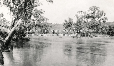
... melbourne Published in the Diamond Creek Basin Study, 1980 and identified at Diamond Creek, locality not identified, 1934. The location is actually looking south across the Diamond Creek towards Falkiner Street, beside the Main Road bridge at Eltham South from what is now part of Wingrove Park opposite Antoinette Boulevard. The bridge railing is just visible to the left of image. The large leaning Manna Gum beside the bridge still stands in 2021 alongside the Diamond Creek trail. In 1934 extensive flooding ...Published in the Diamond Creek Basin Study, 1980 and identified at Diamond Creek, locality not identified, 1934. The location is actually looking south across the Diamond Creek towards Falkiner Street, beside the Main Road bridge at Eltham South from what is now part of Wingrove Park opposite Antoinette Boulevard. The bridge railing is just visible to the left of image. The large leaning Manna Gum beside the bridge still stands in 2021 alongside the Diamond Creek trail. In 1934 extensive flooding of the Yarra River and Diamond Creek set new records for flood plain level (Eltham Chronology, EDHS)Black and white photographCopied by Hugh Fisher, Photographer, 6 York Street Eltham A1678B Floods- Eltham - 1934floods, yarra river, eltham, flooding, diamond creek, flood -
 Eltham District Historical Society Inc
Photograph, Eltham - Floods in 1934
... Eltham District Historical Society Inc 728 Main Rd Eltham melbourne To the left of picture is the Main Road Bridge over the Diamond Creek in Eltham South when the Diamond Creek was in flood. The Yarra also was in flood. In early December 1934 ...To the left of picture is the Main Road Bridge over the Diamond Creek in Eltham South when the Diamond Creek was in flood. The Yarra also was in flood. In early December 1934 the "Greatest flood in the history of the Yarra" occured, according to The Argus newspaper. Bridges and houses were swept away with hundreds of people left homeless across the state. The historic 1934 flood of the Diamond Creek and Yarra River set the criteria for future planning with respect to flood water rise.This photo forms part of a collection of photographs gathered by the Shire of Eltham for their centenary project book, "Pioneers and Painters: 100 years of the Shire of Eltham" by Alan Marshall (1971). The collection of over 500 images is held in partnership between Eltham District Historical Society and Yarra Plenty Regional Library (Eltham Library) and is now formally known as 'The Shire of Eltham Pioneers Photograph Collection.' It is significant in being the first community sourced collection representing the places and people of the Shire's first one hundred years.Digital image 4 x 5 inch B&W Negsepp, shire of eltham pioneers photograph collection, eltham, diamond creek (river), 1934 flood, diamond creek, floods, main road bridge -
 Eltham District Historical Society Inc
Photograph, Floodwaters, Diamond Creek, Eltham, 1934
... Eltham District Historical Society Inc 728 Main Rd Eltham melbourne The Diamond Creek in flood near the Main Road bridge at Eltham, Victoria. The Yarra also was in flood. In early December 1934 ...The Diamond Creek in flood near the Main Road bridge at Eltham, Victoria. The Yarra also was in flood. In early December 1934 the "Greatest flood in the history of the Yarra" occured, according to The Argus newspaper. Bridges and houses were swept away with hundreds of people left homeless across the state. The historic 1934 flood of the Diamond Creek and Yarra River set the criteria for future planning with respect to flood water rise.This photo forms part of a collection of photographs gathered by the Shire of Eltham for their centenary project book, "Pioneers and Painters: 100 years of the Shire of Eltham" by Alan Marshall (1971). The collection of over 500 images is held in partnership between Eltham District Historical Society and Yarra Plenty Regional Library (Eltham Library) and is now formally known as 'The Shire of Eltham Pioneers Photograph Collection.' It is significant in being the first community sourced collection representing the places and people of the Shire's first one hundred years.Digital image 4 x 5 inch B&W Neg (2 frames on one neg) 9 x 15.5 cm B&W printflooding, eltham, shire of eltham pioneers photograph collection, sepp, diamond creek (river), floods, 1934 flood, diamond creek -
 Ringwood and District Historical Society
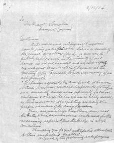
Document, Council flood relief for Mullum Creek flood in Ringwood in 1934
... Ringwood and District Historical Society 125A Warrandyte Road Ringwood North melbourne Correspondence to Council from Ratepayers asking for flood relief resulting from the flood damage in the vicinity of Harrison Street bridge over Mullum Creek in 1934. ...Hand written letters to Ringwood Council re flood relief.Correspondence to Council from Ratepayers asking for flood relief resulting from the flood damage in the vicinity of Harrison Street bridge over Mullum Creek in 1934. -
 Orbost & District Historical Society
black and white photograph, January 1934
... From The Argus (Melbourne) on January 10 1934 "Damage estimated at £500,000 has been caused by the floods in the Orbost district. ...Orbost & District Historical Society Ruskin Street Orbost gippsland From The Argus (Melbourne) on January 10 1934 "Damage estimated at £500,000 has been caused by the floods in the Orbost district. ...From The Argus (Melbourne) on January 10 1934 "Damage estimated at £500,000 has been caused by the floods in the Orbost district. No loss of life occurred, largely owing to the heroic efforts of rescue parties. Many families spent Monday night on the roofs of houses or in trees, surrounded by deep, rushing flood waters." This 1934 flood was devastating, destroying a section of the 1922 Orbost bridge - the centre span was washed away -. wrecking fences, bridges and roads, dumping silt and debris on the rich river flats and drowning cattle. This is a pictorial record of the 1934 flood, a significant event in the history of Orbost.A black / white photograph of floodwaters. In the middle of the water can be see debris including a large spoked wheel. In the background are houses and fences.on back - "near Hilyer's garage at foot of hill Main Street Caravan Park on right" on front at bottom left - "1934"orbost-flood-1934 flood-orbost -
 Orbost & District Historical Society
black and white photographs, January 1934
... These are photographs taken during the 1934 flood at Orbost. From The Argus (Melbourne) on January 10 1934 "Damage estimated at £500,000 has been caused by the floods in the Orbost district. ...Orbost & District Historical Society Ruskin Street Orbost gippsland These are photographs taken during the 1934 flood at Orbost. From The Argus (Melbourne) on January 10 1934 "Damage estimated at £500,000 has been caused by the floods in the Orbost district. ...These are photographs taken during the 1934 flood at Orbost. From The Argus (Melbourne) on January 10 1934 "Damage estimated at £500,000 has been caused by the floods in the Orbost district. No loss of life occurred, largely owing to the heroic efforts of rescue parties. Many families spent Monday night on the roofs of houses or in trees, surrounded by deep, rushing flood waters." This 1934 flood was devastating, destroying a section of the 1922 Orbost bridge - the centre span was washed away -. wrecking fences, bridges and roads, dumping silt and debris on the rich river flats and drowning cattle.These photographs are pictorial records of the 1934 floods at Orbost, a significant event in the history of Orbost.Nine small black / white photographs of flood damage,3253.2 on back - "Waters rushing down Princes Highway and....of......where you see the waves" 3253.3 on back - "rushing flood waters over Lochiel Park Bridge approach at the rear of picture 1934"orbost-flood-1934 flood-orbost -
 City of Melbourne Libraries
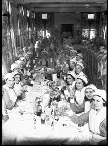
Photograph, Bull, Hugh Jones, 1897-1993, The Nurses' Christmas, Alfred Hospital
... flooding rainstorms which caused havoc on Christmas night. This very Melbourne weather phenomenon was the focus of The Age Boxing Day edition pictorial. At the rear of the room is Matron Grace Wilson C.B.E, already a World War One heroine for setting up and working at Australian military hospitals in Greece, Egypt and France (as seen on the second episode of the 2014 television series Anzac Girls). As Australia’s most highly-ranked peacetime military nurse, Matron Wilson also appears as the only woman in any official capacity at the Dedication of the Shrine of Remembrance in 1934...flooding rainstorms which caused havoc on Christmas night. This very Melbourne weather phenomenon was the focus of The Age Boxing Day edition pictorial. At the rear of the room is Matron Grace Wilson C.B.E, already a World War One heroine for setting up and working at Australian military hospitals in Greece, Egypt and France (as seen on the second episode of the 2014 television series Anzac Girls). As Australia’s most highly-ranked peacetime military nurse, Matron Wilson also appears as the only woman in any official capacity at the Dedication of the Shrine of Remembrance in 1934 ...Published: The Age 26 Dec 1933 page 9 Published title: "THE NURSES' CHRISTMAS." Trove article identifier: http://nla.gov.au/nla.news-article203364946 Description: Group of nurses in uniform enjoying Christmas dinner at the Alfred Hospital. Research by project volunteer Ernie Ward: Alfred Hospital nurses enjoy their Christmas Lunch: The hierarchical system of Nursing and Nurse Training (as indicated by the headwear, armbands and seating positions) is on full display as Alfred Hospital nurses propose a Christmas Lunch toast (strictly non-alcoholic) to The Age photographer, Hugh Bull. Some of the bolder nurses have decorated their headwear in a festive way that would be frowned upon the other 364 days of the year. The soft drinks are Marchants and Elliotts, the flower arrangements feature the highly fashionable gladioli, and the floral patterned curtains have been pulled aside so the summer sunshine can stream in. The sunshine would, in a couple of hours, be replaced by flooding rainstorms which caused havoc on Christmas night. This very Melbourne weather phenomenon was the focus of The Age Boxing Day edition pictorial. At the rear of the room is Matron Grace Wilson C.B.E, already a World War One heroine for setting up and working at Australian military hospitals in Greece, Egypt and France (as seen on the second episode of the 2014 television series Anzac Girls). As Australia’s most highly-ranked peacetime military nurse, Matron Wilson also appears as the only woman in any official capacity at the Dedication of the Shrine of Remembrance in 1934. She can be seen in the grand panorama documenting this occasion (also featured in this exhibition).Photographer notations on slide: "The Nurses' Christmas Alfred Hospital Age 1933 B9".nurses, christmas, 1930-1939 -
 City of Melbourne Libraries
Photograph, Bull, Hugh Jones, 1897-1993, Eucharistic Congress Procession, Collins Street, Melbourne
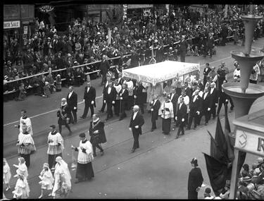
... flooded with light externally from three lamps concealed in the one below it. There is also a painted coat of arms from which spring a trophy of flags.” Note the sign for Tates Tea House - a well-known Melbourne landmark, located in the basement of the Manchester Unity Building. References: RELIGIOUS PAGEANTRY AND FERVOR MARKED CLOSE OF EUCHARISTIC CONGRESS. (1934...flooded with light externally from three lamps concealed in the one below it. There is also a painted coat of arms from which spring a trophy of flags.” Note the sign for Tates Tea House - a well-known Melbourne landmark, located in the basement of the Manchester Unity Building. References: RELIGIOUS PAGEANTRY AND FERVOR MARKED CLOSE OF EUCHARISTIC CONGRESS. (1934 ...Published: The Age 10 December 1934 Published title: RELIGIOUS PAGEANTRY AND FERVOR MARKED CLOSE OF EUCHARISTIC CONGRESS. Published caption: Thousands of men and women marched in the Eucharistic procession yesterday which brought the Congress to a close. The picture above shows the procession headed by the Children of Mary in Bourke-street and turning into Spring-street, in front of Parlia ment House. Right (top) — The procession leaving the starting point at St. Patrick's Cathedral and below, the Papal Legate carrying the Host under a canopy borne by a guard of laymen and preceded by white-clad girls scattering rose leaves, incense bearers and the Papal Chamberlains in their Spanish uniforms. The end of the procession in front of Mount St. Evin’s Hospital from which the final benediction was given by Cardi nal MacRory from an altar on the bal cony. The Papal Legate carrying the Host is passing through the assemblage of surpliced priests. On the left is an aerial picture taken just as the Children of Mary at the head of the procession are taking up their places for the final assembling. In the left top corner of the picture is St Patrick's Cathedral, from which the procession started, and in the right lower corner is Mount St. Evin’s Hospital. The space immediately in front of the hospital was reserved for the processionists while on either side is the crowd that assembled to take part in the final service. Trove article identifier: http://nla.gov.au/nla.news-article205067634 Religious pageantry and fervour The National Eucharistic Congress took place from Sunday 2 to Sunday 9 December 1934. An initiative of the Roman Catholic Church, it was their contribution to Melbourne’s Centenary Celebrations. 200,000 Catholics resided in Melbourne at this time – one quarter of the city’s population. While the Congress was aimed at Catholics, and acted as an opportunity to reinforce their living faith and homage, it contained a variety of events of splendour, solemnity and significance designed to appeal to Melbournians, and would additionally provide incentive for people to travel to Victoria, thereby creating an economic benefit to the state. The Procession of the Blessed Sacrament concluded the week-long Congress. Commencing at St Patrick’s Cathedral, it covered a two-mile route via Gisborne, Collins, Elizabeth and Bourke streets, then to Victoria Parade, where a final benediction was pronounced by Cardinal MacRory from the balcony of Mount St. Evin’s Hospital (today the site of St Vincent’s Private Hospital). An estimated 100,000 took part. Onlookers line Swanston Street, some standing at the entrance to Tate’s Tea House – a well-known Melbourne landmark located in the basement of the Manchester Unity Building. The white-veiled Children of Mary Sodalists strew rose petals in the path of the canopy, covering the jewelled Monstrance containing the Blessed Sacrament of consecrated Host (bread) and carried by the Cardinal. Church hierarchy in scarlet robes walk alongside, followed by incense bearers, the Papal Chamberlains in their Spanish uniforms, and a guard of honour of laymen of the city and country parishes. In the foreground is a tiered pole. This is one of 800 “Venetian Lights” specifically installed for the Centenary along all principal thoroughfares. “The poles are painted white, the superstructure resembling three trumpet lilies are made of durable fibro-cement, and their colour scheme deepens from clear yellow on the top cone to orange on the lowest, with slender rims of vermilion and white. Each cone is flooded with light externally from three lamps concealed in the one below it. There is also a painted coat of arms from which spring a trophy of flags.” – Australian Home Beautiful Featured in "Newsworthy: Melbourne in photographs 1933-1936" exhibition at East Melbourne Library, October to December 2023. Exhibition caption by project volunteer, Louise McKenzie. Research by project volunteer, Louise McKenzie: This photo was taken on Sunday 9 December 1934, looking from the Melbourne Town Hall (corner of Swanston and Collins streets) across the road to the Manchester Unity Building. This is the afternoon procession concluding the Catholic Church’s National Eucharistic Congress in Melbourne - a procession of the Blessed Eucharist through the Melbourne city. It commenced at St Patrick’s Cathedral, and covered a two mile route via Gisborne, Collins, Elizabeth and Bourke streets, then to Victoria Parade where a final benediction was pronounced by the Cardinal from the balcony of Mount St. Evin’s Hospital (present day St Vincent’s Private Hospital). An estimated 100,000 took part in the march. The people lining the streets a men in suits and hats, women in coats and hats, and children in their “Sunday best”, kneeling beside the road, many with their hands clasped in front of them. The small girls ahead of the canopy covering the Host are pale-blue clad, white veiled Children of Mary Sodalists, who strew rose petals to pave the way of the Cardinal carrying the jewelled Monstrance (Blessed Sacrament of consecrated Host (bread)), together with church heirarchy wearing scarlet robes. Behind came incense bearers and the Papal Chamberlains in their Spanish uniforms, followed by a guard of honour of laymen of the city and country parishes. The Children of Mary Sodalities was a religious body which aimed at fostering in its members an ardent devotion, reverence, and filial love towards the Blessed Virgin Mary, initially embracing the pupils and orphans of the schools and institutions of the Sisters of Charity of St Vincent de Paul. In 1847, Blessed Pius IX affiliated them to the Jesuit Roman Sodality. They were distinguished by a medal suspended from a blue ribbon, and once a fully-fledged a Child of Mary wore a distinctive blue cape. On the extreme right foreground of the photo can be seen an intriguing piece of artistic design – a tiered pole. This is one of the 800 “Venetian Lights” specifically installed for Melbourne’s Centenary along all principal thoroughfares. “The poles are painted white, the superstructure resembling three trumpet lilies are made of durable fibro-cement, and their colour scheme deepens from clear yellow on the top cone to orange on the lowest, with slender rims of vermilion and white. Each cone is flooded with light externally from three lamps concealed in the one below it. There is also a painted coat of arms from which spring a trophy of flags.” Note the sign for Tates Tea House - a well-known Melbourne landmark, located in the basement of the Manchester Unity Building. References: RELIGIOUS PAGEANTRY AND FERVOR MARKED CLOSE OF EUCHARISTIC CONGRESS. (1934, December 10). The Age (Melbourne, Vic. : 1854 - 1954), p. 11. Retrieved September 14, 2023, from http://nla.gov.au/nla.news-article205067634 Eucharistic Congress (1934, December 1). The Argus (Melbourne, Vic. : 1848 - 1957), p. 11. Retrieved January 23, 2024, from http://nla.gov.au/nla.news-article10997817 National Eucharistic Congress, Melbourne. (1934, December 6). The Catholic Press (Sydney, NSW : 1895 - 1942), p. 28. Retrieved January 23, 2024, from http://nla.gov.au/nla.news-article104371824 'The year of the Melbourne Eucharistic Congress: 1934.' The Campion Society, https://campion.australiancardijninstitute.org/ch-7-the-year-of-the-melbourne-eucharistic-congress-1934/ 'Melbourne Eucharistic Congress 1934.' Panoramic photograph, https://emhs.org.au/catalogue/emdf0123 The National Eucharistic Congress, Melbourne, Australia December 2nd-9th, 1934. Edited by Rev. J.M. Murphy and Rev. F. Moynihan, The Advocate Press, Melbourne. 'Children of Mary Sodalists', Wikipedia, https://en.wikipedia.org/wiki/Sodality_of_Our_Lady 'Dressing Melbourne for the Duke' (1934, October 1). The Australian home beautiful : a journal for the home builder, p. 21, 58. Retrieved September 14, 2023, from http://nla.gov.au/nla.obj-2950922209 Photographer notations on slide: "Eucharistic Congress Procession on Swanston St B61" [sic - actually Collins Street].events, religion, parades, catholic church -
 City of Melbourne Libraries
Photograph, Bull, Hugh Jones, 1897-1993, Princes Bridge Centenary pylons under construction
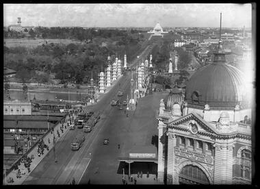
... flood the panels with a deep red light. The decorative painted shields and flagpoles/pennants were illuminated by three 200 watt projectors concealed in the roof of each pylon, and were part of an electric night light decoration scheme involving 28 miles of wire to supply more than 20,000 lights. An article in the Argus on 18 October 1934 provided minute detail of the lighting erected in Melbourne...flood the panels with a deep red light. The decorative painted shields and flagpoles/pennants were illuminated by three 200 watt projectors concealed in the roof of each pylon, and were part of an electric night light decoration scheme involving 28 miles of wire to supply more than 20,000 lights. An article in the Argus on 18 October 1934 provided minute detail of the lighting erected in Melbourne ...Princes Bridge Centenary pylons under construction Possibly taken from Young and Jacksons Hotel (formerly Princes Bridge Hotel) on the corner of Flinders and Swanston streets, Flinders Street Station’s clocks and main entrance dominate, along with its distinctive copper dome and decorative façade. The time on the main clock is 1.40pm, and the sign underneath, reflecting Melbourne’s upcoming Centenary reads, “We must accommodate our Centenary visitors! Citizens! Do your share by taking paying guests.” At left is the original Princes Bridge Station, today the site of Federation Square. The riverside tram terminus advertises a Café/Tobacconist/Refreshment Room selling cigars & cigarettes, fountain drinks & confectionery, and in smaller text: “Leave your boot repairs here”. Nearly everyone is dressed in dark suits, coats and hats. The footpaths are wide and there are no traffic lights. The roadway stretches towards the Shrine of Remembrance, not yet dedicated but very dominant on the skyline. Government House is clearly visible across the wide parkland that would come to be known as Kings Domain and that is an area of deep importance to the people of the Eastern Kulin. Originally, Birrarung was part of a network of swamps and lagoons linked to the course of the river. From 1896, Public Works Department engineer Carlo Catani, oversaw a new channel to straighten the river and the swamps and lagoons were filled with spoil from the channel works. From the same vantage point today, only the top of the tower of Government House would be visible. The photo captures the pylons along Princes Bridge, mid-construction and being installed to mark Melbourne’s Centenary. The pylons were not without controversy. Both The Argus and The Age bemoaned them for being “made almost entirely of imported softwood timber”, denying work to native hardwood timber workers and sawmillers, and leading visitors to think Australia did not have its own exceptional native hardwoods. The pylons were also variously described in their incomplete state, as unimaginative and resembling an oilfield. Published: The Age 5 September 1934 Featured in "Newsworthy: Melbourne in photographs 1933-1936" exhibition at East Melbourne Library, October to December 2023. Exhibition caption by project volunteer, Louise McKenzie Photographer notations on slide: "Pylons + St Kilda Rd C57" Published: Age (Melbourne, Vic. : 1854 - 1954), Wednesday 5 September 1934, page 11 Published title: DECORATIONS -- THEN AND NOW. Published caption: "Although not completed yet, some impression of the effect of the decorations on Princes-bridge may be obtained from the first picture which shows the majestic sweep of St Kilda road with the Shrine of Remembrance and Government House dominating the horizon. The area to the left of St. Kilda-road and in front of Government House is portion of the area which it is proposed to call the King's Domain, which extends to Domain-road and Anderson-street..." Description: East-facing, elevated view of Flinders Street Station and Princes Bridge, featuring partially completed pylons erected for Melbourne's Centenary celebrations. The Shrine of Remembrance and Government House can be seen in the distance. In the foreground are trams, cars and trucks, pedestrians, Batman Avenue tram terminus and refreshment rooms. Signage on Flinders Street Station encourages citizens to accommodate Centenary visitors. The Melbourne Centenary was held 1934-35 in celebration John Batman's proclamation that Melbourne "the place for a village". Centenary events included a visit by Prince Henry, Duke of Gloucester. A Centenary Cake measuring 50 feet in height and ten tons in weight was cut into 250,000 pieces and sold at 1 shilling per piece for charity. Spectacular floodlighting of city landmarks, the creation of the Pioneer Women's Memorial Garden, and the MacRobertson Air Race from London, were other notable activities. Research by project volunteer, Louise McKenzie: The photo in The Age collage of 5 September 1934 has a slightly cropped foreground. The original photo has been taken from an elevated vantage point, most probably the roof of the Nicholas Building on the corner of Flinders and Swanston streets. The right foreground is dominated by the main “clocks” entrance to Flinders Street Station, showing its distinctive copper dome and decorative façade. The time on the main clock is 1.40 pm. The main sign on the front of the Station reads, "We Must Accommodate our Centenary Visitors! Citizens! Do your share by taking paying guests. Write to The Official Centenary Accommodation Bureau, 436 Collins St. City. Tel M 4671”. Another sign at eye level at the main entrance says: “Cheap Trips on Sundays”. The sign on the end of the roof along the eastern side of the station reads, “The Babies Need Your Help! Support Broadmeadows Foundling Hospital Appeal. July and August”. Run by the Sisters of St Joseph of the Sacred Heart, St Joseph’s Foundling Hospital was a purpose built infants’ home for up to 300 babies, plus accommodation for expectant mothers, mainly single women. In the early 1930s, the department (Victorian Children’s Welfare Department) contracted St Joseph’s Foundling Hospital to care for an additional 60 infant state wards, and up to 175 non wards at any given time. In 1931 it also operated a mothercraft training school. The centre foreground shows the commencement of Princes Bridge. Beneath the left side of the bridge was the site of the original Princes Bridge Station, by this time incorporated into Flinders Street Station, and today the area is the site of Federation Square. It was linked to Flinders Street station by the railway tracks that ran underneath the northern approach to the bridge. This photo shows a tram terminus which has a Café/Tobacconist/Refreshment Room, selling cigars & cigarettes, fountain drinks & confectionary, and a sign: Leave your boot repairs here. In the foreground is a wide roadway running south/north, comprising two vehicle lanes each heading north/south, and a central section containing two sets of tram tracks. There are cars, buses and delivery vans on the roadway. The trams visible are Glen Iris (Route No. 6; tram no. 448), Toorak (Route No. 8, tram no. 333), ? (No. 7), ? (No. 1), and ? (No. 2A). The footpaths are extremely wide. There is a square newspaper/magazine stand on the eastern side footpath. And also a “Ferry” sign. There are no traffic lights, but a policeman is visible on the roadway. There are pedestrians – men, women, children, a porter with trolley, women with prams. Clothing comprises dark suits, coats and hats for nearly everyone. There are double headed “Collins Street” lights along the side of the roadway, and along the northern riverbank. The roadway in the foreground is an extension of Swanston Street, which becomes Princes Bridge, then St Kilda Road, stretching towards the Shrine of Remembrance, and diverting past it. The Shrine had not yet been officially dedicated, and looks very white and dominant on the skyline. On the LHS of St Kilda Road, Government House is clearly visible across the wide parkland to be known as Kings Domain. The Kings Domain area is important to the people of the Eastern Kulin nation, and also has historical importance for its association with the early settlement of Melbourne and the foundation of British colonial administration in Victoria. On the southern side of the Yarra River (Birrarung) an historic rowing boathouse is visible, located adjacent to the Alexandra Gardens. Originally Birrarung was part of a network of swamps and lagoons linked to the course of the river. From 1896, under the guidance of engineer Carlo Catani* a new channel to straighten the river was created and the swamps and lagoons were filled with spoil from the channel works. The gardens were then created and completed in time for a Royal visit by the Duke of York in May 1901. The gardens are named after Alexandra of Denmark, the wife of King Edward VII. Both these areas, plus the Royal Botanic Gardens Victoria, Shrine of Remembrance Reserve, Sidney Myer Music Bowl, Government House, and the Queen Victoria Gardens together form the Domain Parklands. The extent of the subsequent plantings is evident today, where from the same vantage point only the top of the tower of Government House would be visible. *Catani was born in Florence in 1852, but after arriving in Melbourne worked as a civil engineer for the Victorian Government. His last major project was the reclamation of the foreshore of St Kilda, envisaged in the style of a European resort, complete with a split level esplanade, bathing pavilions, dance halls, amusements and a French-Italian style of landscape complete with palms. The gardens at the end of Fitzroy Street, St Kilda, now bear his name. The historic boathouse visible across the Yarra is another glimpse into Melbourne’s past. “Boathouse Row” comprises 7 amateur rowing clubs, the first established in 1859 (Melbourne University Boat Club). Other Clubs were Richmond, Melbourne, Banks, Melbourne Grammar School, Yarra Yarra and Mercantile. South of the river and west of the bridge is an area today developed into the Melbourne arts precinct of Hamer Hall and the Arts Centre. But at this time it was the home of Wirths Olympia Circus, which comprised Wirths Pleasure Park (an amusement park), a 5,000 seat auditorium – Hippodrome, a roller skating rink, a glaciarium, a cinema, and the Green Mill Dance Hall. Dog shows were also held at Olympia. The Green Mill Dance Hall closed in 1950, and the remainder of the Wirth buildings on site were destroyed by fire in December 1953. The feature of the photo is the pylons erected along Princes Bridge to mark Melbourne’s Centenary in 1934. The sixteen plastered pylons were designed by Roy Prentice, the second person to qualify as an architect at The University of Melbourne’s Bachelor of Architecture degree, in 1933, aged 27. Simon Reeves in his article marking the 100th birthday of Roy Prentice on 20 June 2006 reports that the State Electricity Commission sponsored this work, and the Argus reported that “… the pylons were “illuminated from within to give the effect of soft radiance”. Australia Home Beautiful 1 Oct 1934 reports in a very detailed and comprehensive article: The 10 taller pylons, including flagpole, were 48 ft, with a base of 8 ft. Timber-framed and faced with fibrous plaster and galvanised sheet iron, each structure was securely bolted to a concrete foundation three feet in depth. Panels of glass let into the shaft of each pylon were indirectly lit by 40, 100 watt lamps, and the upper bank of internal lamps were dyed so as to flood the panels with a deep red light. The decorative painted shields and flagpoles/pennants were illuminated by three 200 watt projectors concealed in the roof of each pylon, and were part of an electric night light decoration scheme involving 28 miles of wire to supply more than 20,000 lights. An article in the Argus on 18 October 1934 provided minute detail of the lighting erected in Melbourne for the Centenary, converting it “… into a coloured fairyland by night.” The estimated cost of 10 pounds per hour the lights were on. The display included 800 standard light poles 30 feet high which were tiered with electric bulbs concealed in inverted cones, 138 specially designed “Venetian poles” draped in flags trophies and streamers. The streets included in the electric night light decoration scheme were Bourke Street from Spring to William, the entire length of Collins Street, Flinders Street from Elizabeth to Spring, Lonsdale Street from Elizabeth to Swanston, Swanston and Elizabeth Streets from Flinders to Lonsdale, and parts of Springs and Spencer Streets. Together with the Princes Bridge pylons, approximately 28 miles of wire was required to supply power to the more than 20,000 lights. And that is just in the city of Melbourne. It was estimated the same amount of lighting was duplicated among other local councils. The pylons were not without controversy. The Argus on 28 August 1934 in an article headed “Imported Timber in Pylons” reported that the Princes Bridge pylons are “made almost entirely of imported softwood timber”, and have therefore denied work to native hardwood timber workers and sawmillers. The same day the Melbourne Age ran a similar story, bemoaning the fact that foreign oregon had been used which may lead tourists to think Australia did not have its own exceptional native hardwoods. A Camberwell City Councillor described the pylons as unimaginative, and the Herald reported that skeletons of pylons for the Centenary decorations in their present form led the area to resemble an oilfield! The Yarra River and Princes Bridge have long been a focal point of Melbourne life. In the early days of European settlement in Melbourne a rope-hauled punt carried people across the Yarra River. A surge in population and increased shipping traffic created a need for a bridge. There was difficulty in agreeing on a suitable site for the bridge (options were crossing at Elizabeth, Swanston, Queen or Market Streets), but the NSW Government favoured Swanston Street and the Melbourne Town Council decided on a temporary bridge across the Yarra spanning from the foot of Swanston Street. This first bridge was a single span timber toll bridge designed by Scottish born bridge designer David Lennox, and completed in 1845. It was 120 feet long, had a roadway of 17 feet wide, and a footpath on one side of 4 feet. It was leased to the Melbourne Bridge Company in the name of Robert A Balbirnie. The tollhouse was on the north side of the river and the toll keeper, Patrick Doherty, was credited with saving nine lives during the four years he was in charge of the toll station. The second bridge was stone (completed 1850), and named Prince’s Bridge after the HRH Prince of Wales, later Edward VII. It was designed with an elliptical single arc and an exceedingly small rise in proportion to the span. However, this design created an obstacle for flood waters, and together with Melbourne’s increasing population it was quickly apparent that a new bridge was required. At its opening on 15 November 1850 coincided with the imminent declaration of Victoria as a separate colony, it provided a moment of great celebration for Melbournians and “The opening ceremony was described as the grandest processional display witnessed in the colony.” (ToMelbourne.com.au) Princes Bridge in its present form, as depicted in this photograph, was designed by Jenkins, D’Ebro and Grainger, and constructed in 1886-88 by David Munro. John Grainger (father of Australian composer Percy Grainger) did the majority of the design work for the bridge. The structure was to have three arches each 96 feet wide measured across the river, and the banks on both sides were raised to allow more space for floodwater to flow. St Kilda Road was originally many feet below the current level. The bridge is of architectural significance for its substantial size, giant half columns, extensive use of wrought and cast iron, decorative elements (cast-iron lamps) and the skilled stonemasonry in the construction of the abutments and piers. Its main design features are similar to those of Blackfriars Bridge in London (1870). The bluestones were quarried from Footscray, the Malmsbury stones were from quarries at Kyneton, and the granite from Harcourt. The cost was met by the State of Victoria, City of Melbourne, and six out of seven of its municipalities, and their coats of arms feature on the bridge. The building of the bridge reflected the boom period of Melbourne, including the Victorian gold rush 1851- late 1860s, and its contractor, David Munro, was also responsible for the construction of Queens Bridge and Sandridge Railway Bridge. The Centenary pylons are no longer in place, but today this intersection still plays a major part in Melbourne’s daily life: people still meet “under the clocks” at Flinders Street station, and the route in and out of the city along St Kilda Road is often a feature of parades such as Moomba, the Grand Final Parade, and of course the Anzac Day Parade which commences at the Princes Bridge intersection and finishes at the Shrine of Remembrance. There are many tram routes, which cross the Bridge, and it directs pedestrians towards the Arts Precinct, the various components of Domain Park, plus the Southbank restaurant and rowing precincts. Even though this is a street scene, it feels very intimate; the viewer is instantly immersed in the activity of a Melbourne afternoon, looking down St Kilda Road from a viewpoint near today’s Federation Square. References: DECORATIONS -- THEN AND NOW. (1934, September 5). The Age (Melbourne, Vic. : 1854 - 1954), p. 11. Retrieved September 21, 2023, from http://nla.gov.au/nla.news-article205880269 'Flinders Street railway station', Wikipedia, https://en.wikipedia.org/wiki/Flinders_Street_railway_station 'St Joseph’s Foundling Hospital (1901-75)', Finding Records, Department of Health and Human Services, State of Victoria, https://www.findingrecords.dhhs.vic.gov.au/collectionresultspage/St-JosephsFoundling-Hospital-Babies-Home#departmental-administration 'Alexandra Gardens', City of Melbourne, https://www.melbourne.vic.gov.au/community/parks-open-spaces/major-parks-gardens/Pages/alexandra-gardens.aspx 'Wirths Circus', Wikipedia, https://en.wikipedia.org/wiki/Wirth's_Circus 'Roy Prentice: Centenary Architect', Built Heritage Pty Ltd, Simon Reeves, https://www.builtheritage.com.au/downloads/prentice.pdf 'Princes Bridge', Heritage Council Victoria, https://vhd.heritagecouncil.vic.gov.au/places/817 PORT PHILLIP. (1846, April 1). The Sydney Morning Herald (NSW : 1842 - 1954), p. 3. Retrieved September 21, 2023, from http://nla.gov.au/nla.news-article12886251 'Edward VII', Wikipedia, https://en.wikipedia.org/wiki/Edward_VII 'Princes Bridge', ToMelbourne.com, https://tomelbourne.com.au/princes-bridge/ 'Princes Bridge', eMelbourne, https://www.emelbourne.net.au/biogs/EM01189b.htm 'Princes Bridge', Australia for everyone, http://australiaforeveryone.com.au/files/melbourne/princes-bridge.html 'Victorian gold rush', Wikipedia, https://en.wikipedia.org/wiki/Victorian_gold_rush IMPORTED TIMBER IN PYLONS (1934, August 28). The Argus (Melbourne, Vic. : 1848 - 1957), p. 9. Retrieved September 21, 2023, from http://nla.gov.au/nla.news-article10952507 Princes-Bridge Pylons. (1934, August 28). The Age (Melbourne, Vic. : 1854 - 1954), p. 7. Retrieved September 21, 2023, from http://nla.gov.au/nla.news-article205532235 Pylons Appear Near Princes Bridge (1934, August 18). The Herald (Melbourne, Vic. : 1861 - 1954), p. 1. Retrieved September 21, 2023, from http://nla.gov.au/nla.news-article243104375 PRINCES-BRIDGE PYLONS. (1934, September 20). The Age (Melbourne, Vic. : 1854 - 1954), p. 10. Retrieved September 21, 2023, from http://nla.gov.au/nla.news-article205873535 28 Miles of Wire (1934, October 18). The Argus (Melbourne, Vic. : 1848 - 1957), p. 1 (The Junior Argus). Retrieved September 21, 2023, from http://nla.gov.au/nla.news-article10977836 'Historical references for Boathouse Row, Melbourne', http://boathouserowmelbourne.com.au/history/ 'ITALIAN DELEGATION TO HONOUR CARLO CATANI, DESIGNER OF THE ST KILDA FORESHORE, St Kilda Historical Society, 2001, https://web.archive.org/web/20070928061938/http://www.skhs.org.au/~SKHSarticles/articles/Carlo_Catani.html# HISTORY IN LIGHTS (1934, July 12). The Herald (Melbourne, Vic. : 1861 - 1954), p. 16. Retrieved September 21, 2023, from http://nla.gov.au/nla.news-article243172436 'Dressing Melbourne for the Duke', The Australian home beautiful: a journal for the home builder. Vol 12 No. 10 (1 October 1934), page 21, 58. Retrieved September 14, 2023, from http://nla.gov.au/nla.obj-2950922209Photographer notations on slide: "Pylons + St Kilda Rd C57".centenaries, bridges, lighting, flinders street railway station -
![Photograph, Bull, Hugh Jones, 1897-1993, View looking along St Kilda Road [completed Centenary pylons on Princes Bridge]](/media/collectors/68524623ad73480cc6fce59f/items/68f089892b74709eaf6d30e8/item-media/68f089af2b74709eaf6d372a/item-fit-380x285.jpg?cb=6) City of Melbourne Libraries
City of Melbourne LibrariesPhotograph, Bull, Hugh Jones, 1897-1993, View looking along St Kilda Road [completed Centenary pylons on Princes Bridge]
... flood them with a deep red light. The shields and flagpoles were illuminated by three 200 watt concealed projectors, part of an electric night light decoration scheme involving 28 miles of wire to supply more than 20,000 lights. Melbourne was converted into “a coloured fairyland by night”. References: DECORATIONS -- THEN AND NOW. (1934...flood them with a deep red light. The shields and flagpoles were illuminated by three 200 watt concealed projectors, part of an electric night light decoration scheme involving 28 miles of wire to supply more than 20,000 lights. Melbourne was converted into “a coloured fairyland by night”. References: DECORATIONS -- THEN AND NOW. (1934 ...Princes Bridge Centenary pylons complete Even though this is a street scene, it feels very intimate; we are instantly immersed in the activity of a Melbourne afternoon, looking down St Kilda Road from a viewpoint near today’s Federation Square. The focus is on the Centenary Pylons, erected on Princes Bridge to mark Melbourne’s Centenary in 1934. The sixteen plastered pylons were designed by Roy Prentice, the second person to qualify as an architect at the University of Melbourne in 1933, and aged just 27. The State Electricity Commission sponsored the work and The Argus reported that the pylons were “illuminated from within to give the effect of soft radiance”. Australia Home Beautiful reported that the taller pylons were 48 feet high. Timber-framed and faced with fibrous plaster and galvanised sheet iron, each structure was bolted to a concrete foundation three feet in depth. Panels of glass were indirectly lit by forty 100 watt lamps, and the upper bank of lamps were dyed so as to flood them with a deep red light. The shields and flagpoles were illuminated by three 200 watt concealed projectors, part of an electric night light decoration scheme involving 28 miles of wire to supply more than 20,000 lights. Melbourne was converted into “a coloured fairyland by night”. Featured in "Newsworthy: Melbourne in photographs 1933-1936" exhibition at East Melbourne Library, October to December 2023. Exhibition caption by project volunteer, Louise McKenzie Photographer notations on slide: "View looking along St Kilda Road C57" Published: (1934, September 5). The Age (Melbourne, Vic. : 1854 - 1954), p. 11. Published title: DECORATIONS -- THEN AND NOW. Published caption: "The second picture shows one of the Princes-bridge pylons completed..." Trove article identifier: http://nla.gov.au/nla.news-article205880269 Research by project volunteer, Louise McKenzie: Even though this is a street scene, it feels very intimate; we are instantly immersed in the activity of a Melbourne afternoon, looking down St Kilda Road from a viewpoint near today’s Federation Square. The focus is on the Centenary Pylons, erected on Princes Bridge to mark Melbourne’s Centenary in 1934. The sixteen plastered pylons were designed by Roy Prentice, the second person to qualify as an architect at the University of Melbourne in 1933, and aged just 27. The State Electricity Commission sponsored the work and The Argus reported that the pylons were “illuminated from within to give the effect of soft radiance”. Australia Home Beautiful reported that the taller pylons were 48 feet high. Timber-framed and faced with fibrous plaster and galvanised sheet iron, each structure was bolted to a concrete foundation three feet in depth. Panels of glass were indirectly lit by forty 100 watt lamps, and the upper bank of lamps were dyed so as to flood them with a deep red light. The shields and flagpoles were illuminated by three 200 watt concealed projectors, part of an electric night light decoration scheme involving 28 miles of wire to supply more than 20,000 lights. Melbourne was converted into “a coloured fairyland by night”. References: DECORATIONS -- THEN AND NOW. (1934, September 5). The Age (Melbourne, Vic. : 1854 - 1954), p. 11. Retrieved September 21, 2023, from http://nla.gov.au/nla.news-article205880269 'Dressing Melbourne for the Duke', The Australian home beautiful: a journal for the home builder. Vol 12 No. 10 (1 October 1934), page 21, 58. Retrieved September 14, 2023, from http://nla.gov.au/nla.obj-2950922209 28 Miles of Wire (1934, October 18). The Argus (Melbourne, Vic. : 1848 - 1957), p. 1 (The Junior Argus). Retrieved September 21, 2023, from http://nla.gov.au/nla.news-article10977836Photographer notations on slide: "View looking along St Kilda Road C57".centenaries, 1930-1939, bridges -
 Dandenong & District Historical Society
Journal, Dandenong & District Historical Society, Gipps-Land Gate Vol36 No2, 2009
... Dandenong & District Historical Society 1st Floor, 39 Clow Street Dandenong melbourne Hotel history Early education in Dandenong Interesting Milestones Family Histories An interesting group of Early Dandenong Personalities, Places and Events A5 size publication of the Gipps-Land Gate, October, 2009 featuring an old picture of Dandenong on the cover. Letters To The Editor The Floods Of 1934 ...An interesting group of Early Dandenong Personalities, Places and EventsA5 size publication of the Gipps-Land Gate, October, 2009 featuring an old picture of Dandenong on the cover. Letters To The Editor The Floods Of 1934 Dandenong Market Bruce Cochrane 1898 - 1989 Dandenong Circa 1919 - 1923 My Childhood - Jill Nancarow TheTaylor Family - Lawrie Taylor Frank Holohan Vale: David Asher, Kevin McIntyre, Eric Eckstein Reminiscences Of A Man Called Ted (Saggers) 1911-1947 Lavender Lace Lingerie One Sunday In September Society News Harking Back 75 Years An interesting group of Early Dandenong Personalities, Places and Eventshotel history, early education in dandenong, interesting milestones, family histories -
 Dandenong & District Historical Society
Journal, Dandenong & District Historical Society, Gipps-Land Gate Vol43 No1, 2016
... Dandenong & District Historical Society 1st Floor, 39 Clow Street Dandenong melbourne Hotel history Early education in Dandenong Interesting Milestones Family Histories An interesting group of Early Dandenong Personalities, Places and Events A5 size publication of the Gipps-Land Gate, April, 2016 featuring an old picture of Dandenong on the cover. We Miss You Jan History Of Floods At Dandenong The Carrum Swamp South-West Of Dandenong The Dandenong Creek At Dandenong Other Flooding In Dandenong Retarding Basins And Flood Plains The 1934 ...An interesting group of Early Dandenong Personalities, Places and EventsA5 size publication of the Gipps-Land Gate, April, 2016 featuring an old picture of Dandenong on the cover. We Miss You Jan History Of Floods At Dandenong The Carrum Swamp South-West Of Dandenong The Dandenong Creek At Dandenong Other Flooding In Dandenong Retarding Basins And Flood Plains The 1934 Flood Drownings In The Dandenong Creek At Or Below Dandenong Dandenong Panoramic (Lunar Dandenong) Drive-In Theatre Harking Back 73 Years Official Launch Of CGD Archive Facility President's Report An interesting group of Early Dandenong Personalities, Places and Eventshotel history, early education in dandenong, interesting milestones, family histories