Showing 51 items matching "floods - kew - 1934"
-
 Kew Historical Society Inc
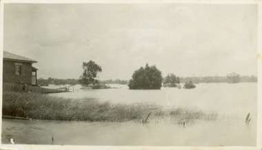
Photograph, Floods in North Kew, 1934
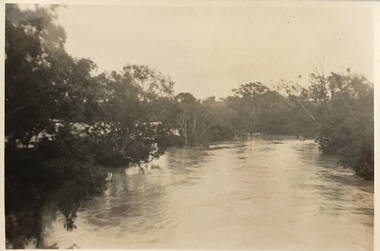
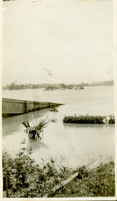
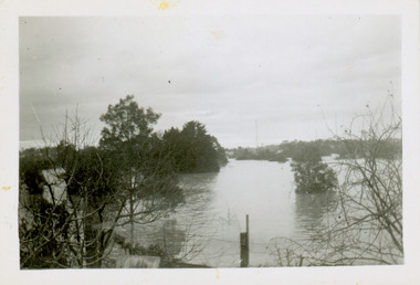
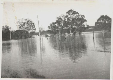
... floods (kew) 1934...Kew] suffered considerably. Mr Wade speaks of 80 acres, out of 100 acres of his cultivated paddock, covered by water." Newspapers continued to describe major flooding in Kew in 1863, 1869, 1878, 1880, 1889, 1891, 1916 and 1934. ...Floods in North Kew, 1934. Flood near the lagoon (Billabong?)... yarra river Floods in North Kew, 1934. Flood near the lagoon (Billabong?) ...Living with natural processes was frequently a challenge to early European settlers and later residents of what was in the 1850s administered by the Borondara Road Board. This was compounded by the area being bounded on three sides by rivers (Yarra River, Koonung Creek and Gardiner's Creek). In 1849, the historian James Bonwick recorded that "our district [Kew] suffered considerably. Mr Wade speaks of 80 acres, out of 100 acres of his cultivated paddock, covered by water." Newspapers continued to describe major flooding in Kew in 1863, 1869, 1878, 1880, 1889, 1891, 1916 and 1934. While the construction of the Upper Yarra dam in 1957 reduced the levels of flowing downstream, local and riverine floods continue.The Kew Historical Society's pictures and map collections testify to the impact of flooding in the district. They have historical importance in documenting the extent of flooding in the district and its affects on homes, services and recreation. Numerous photographs record flooding throughout the Twentieth Century.Floods in North Kew, 1934. Flood near the lagoon (Billabong?)floods (kew) 1934, yarra river -
 Kew Historical Society Inc
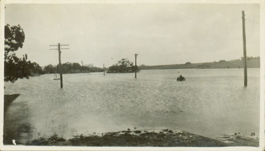
Photograph, Floods in North Kew, 1934
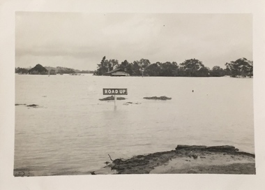
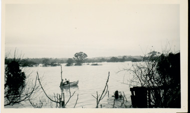
... floods (kew) 1934...The great flood of 1934 in Melbourne was one of the most devastating floods since records began. The floods affected all of Melbourne, including Kew....Floods in North Kew, 1934. Flood near Lagoon (Billabong?) ...The floods affected all of Melbourne, including Kew. Locally significant photographs of the impact of flooding in Kew in 1934 floods (kew) 1934 yarra river Floods in North Kew, 1934. ...The great flood of 1934 in Melbourne was one of the most devastating floods since records began. The floods affected all of Melbourne, including Kew.Locally significant photographs of the impact of flooding in Kew in 1934Floods in North Kew, 1934. Flood near Lagoon (Billabong?) Willsmere Road, North Kew.floods (kew) 1934, yarra river -
 Kew Historical Society Inc
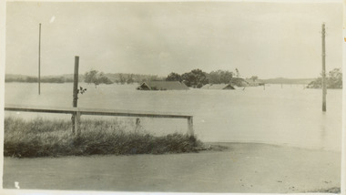
Photograph, Floods in North Kew, 1934
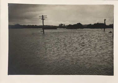
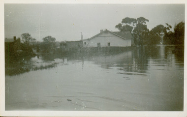
... floods (kew) 1934...Kew] suffered considerably. Mr Wade speaks of 80 acres, out of 100 acres of his cultivated paddock, covered by water." Newspapers continued to describe major flooding in Kew in 1863, 1869, 1878, 1880, 1889, 1891, 1916 and 1934. ...Floods in North Kew, 1934. Chipperfield's Boat House under flood.... yarra river chipperfield's boat house Floods in North Kew, 1934. Chipperfield's Boat House under flood. ...Living with natural processes was frequently a challenge to early European settlers and later residents of what was in the 1850s administered by the Borondara Road Board. This was compounded by the area being bounded on three sides by rivers (Yarra River, Koonung Creek and Gardiner's Creek). In 1849, the historian James Bonwick recorded that "our district [Kew] suffered considerably. Mr Wade speaks of 80 acres, out of 100 acres of his cultivated paddock, covered by water." Newspapers continued to describe major flooding in Kew in 1863, 1869, 1878, 1880, 1889, 1891, 1916 and 1934. While the construction of the Upper Yarra dam in 1957 reduced the levels of flowing downstream, local and riverine floods continue.The Kew Historical Society's pictures and map collections testify to the impact of flooding in the district. They have historical importance in documenting the extent of flooding in the district and its affects on homes, services and recreation. Numerous photographs record flooding throughout the Twentieth Century.Floods in North Kew, 1934. Chipperfield's Boat House under flood.floods (kew) 1934, yarra river, chipperfield's boat house -
 Kew Historical Society Inc
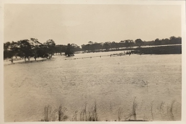
Photograph, Floods in North Kew, 1934
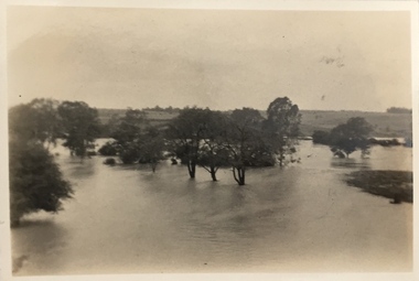
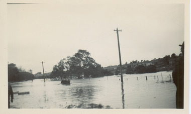
... floods (kew) 1934...Kew] suffered considerably. Mr Wade speaks of 80 acres, out of 100 acres of his cultivated paddock, covered by water." Newspapers continued to describe major flooding in Kew in 1863, 1869, 1878, 1880, 1889, 1891, 1916 and 1934. ...Floods in North Kew, 1934. Unidentified location on the Yarra Flood Plain at Kew.... yarra river Floods in North Kew, 1934. Unidentified location on the Yarra Flood Plain at Kew. ...Living with natural processes was frequently a challenge to early European settlers and later residents of what was in the 1850s administered by the Borondara Road Board. This was compounded by the area being bounded on three sides by rivers (Yarra River, Koonung Creek and Gardiner's Creek). In 1849, the historian James Bonwick recorded that "our district [Kew] suffered considerably. Mr Wade speaks of 80 acres, out of 100 acres of his cultivated paddock, covered by water." Newspapers continued to describe major flooding in Kew in 1863, 1869, 1878, 1880, 1889, 1891, 1916 and 1934. While the construction of the Upper Yarra dam in 1957 reduced the levels of flowing downstream, local and riverine floods continue.The Kew Historical Society's pictures and map collections testify to the impact of flooding in the district. They have historical importance in documenting the extent of flooding in the district and its affects on homes, services and recreation. Numerous photographs record flooding throughout the Twentieth Century.Floods in North Kew, 1934. Unidentified location on the Yarra Flood Plain at Kew.floods (kew) 1934, yarra river -
![Flooding at Chipperfield's Boathouse [East Kew], 1934](/media/collectors/550653872162f11fb04854aa/items/58cbaad5d0cec425b474bfb1/item-media/58cf6fbdd0cf9f331490feb0/item-fit-380x285.jpg?cb=6) Kew Historical Society Inc
Kew Historical Society IncPhotograph, Flooding at Chipperfield's Boathouse, 1934
... floods (kew)...floods (kew) 1934...Kew] suffered considerably. Mr Wade speaks of 80 acres, out of 100 acres of his cultivated paddock, covered by water." Newspapers continued to describe major flooding in Kew in 1863, 1869, 1878, 1880, 1889, 1891, 1916 and 1934. ...Floods in North Kew, 1934. Chipperfield's Boathouse and the adding Moorings was located beside the Yarra River near the corner of Willsmere and Kilby Roads. ...floods continue. The Kew Historical Society's pictures and map collections testify to the impact of flooding in the district. They have historical importance in documenting the extent of flooding in the district and its affects on homes, services and recreation. Numerous photographs record flooding throughout the Twentieth Century. floods (kew) floods (kew) 1934 ...Living with natural processes was frequently a challenge to early European settlers and later residents of what was in the 1850s administered by the Borondara Road Board. This was compounded by the area being bounded on three sides by rivers (Yarra River, Koonung Creek and Gardiner's Creek). In 1849, the historian James Bonwick recorded that "our district [Kew] suffered considerably. Mr Wade speaks of 80 acres, out of 100 acres of his cultivated paddock, covered by water." Newspapers continued to describe major flooding in Kew in 1863, 1869, 1878, 1880, 1889, 1891, 1916 and 1934. While the construction of the Upper Yarra dam in 1957 reduced the levels of flowing downstream, local and riverine floods continue.The Kew Historical Society's pictures and map collections testify to the impact of flooding in the district. They have historical importance in documenting the extent of flooding in the district and its affects on homes, services and recreation. Numerous photographs record flooding throughout the Twentieth Century.Floods in North Kew, 1934. Chipperfield's Boathouse and the adding Moorings was located beside the Yarra River near the corner of Willsmere and Kilby Roads. The flood reached the roof of the Moorings, which can be seen in the photo.floods (kew), floods (kew) 1934, yarra river -
 Kew Historical Society Inc
Photograph - Country road
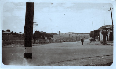
... Original, black and white positive print which the inscription on the reverse incorrectly claims is of Kew during the 1934 floods. The date may be 1934, but there is no evidence of flood waters or of location. ...Inscribed verso: "Yarra Floods Kew 1934" ...Kew Historical Society Inc Kew Court House 188 High Street Kew melbourne unidentified locations Inscribed verso: "Yarra Floods Kew 1934" Original, black and white positive print which the inscription on the reverse incorrectly claims is of Kew during the 1934 floods. ...Original, black and white positive print which the inscription on the reverse incorrectly claims is of Kew during the 1934 floods. The date may be 1934, but there is no evidence of flood waters or of location. The photo is of an intersection with a hotel on the corner in front of which a man is standing. The hotel would appear to be named Russell['s] Hotel. There is also an advertisement for Willys on the hotel verandah. Inscribed verso: "Yarra Floods Kew 1934" unidentified locations -
 Kew Historical Society Inc
Photograph, Flooding of the Outer Circle Railway Bridge, 1934
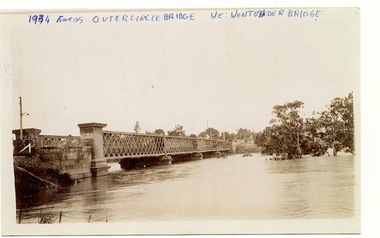
... floods - kew - 1934...Kew Historical Society Inc Kew Court House 188 High Street Kew melbourne floods - kew - 1934 1934 FLOODS / OUTER CIRCLE BRIDGE / WE WENT UNDER BRIDGE OUTER CIRCLE BRIDGE / 1934 FLOODS / (DAD & I) / WE TOOK OUR CANOE UNDER THE BRIDGE, & CARL SIERAKOSKI WAS IN HIS CANOE AT THE TIME & WROTE DADS NAME A. ...One of three digital copies of flooded areas of Kew (1923-34), donated by Jan Coutts of Bulleen in 2019. The handwriting on the originals predates the copy.1934 FLOODS / OUTER CIRCLE BRIDGE / WE WENT UNDER BRIDGE OUTER CIRCLE BRIDGE / 1934 FLOODS / (DAD & I) / WE TOOK OUR CANOE UNDER THE BRIDGE, & CARL SIERAKOSKI WAS IN HIS CANOE AT THE TIME & WROTE DADS NAME A. LUCKE UNDER THE TOP OF THE BRIDGE / NEE (MARY LUCKE) NOW TYACKfloods - kew - 1934 -
 Kew Historical Society Inc
Photograph, Yarra at Fairfield, 1934 Floods, 1934
... floods - kew - 1934...Kew Historical Society Inc Kew Court House 188 High Street Kew melbourne floods - kew - 1934 1934 YARRA FAIRFIELD FROM OPPOSITE RUDDER GRANGE One of three digital copies of flooded areas of Kew (1923-34), donated by Jan Coutts of Bulleen in 2019. ...One of three digital copies of flooded areas of Kew (1923-34), donated by Jan Coutts of Bulleen in 2019. The handwriting on the originals predates the copy.1934 YARRA FAIRFIELD FROM OPPOSITE RUDDER GRANGE floods - kew - 1934 -
 Kew Historical Society Inc
Photograph - Flooding of the Yarra River in North Kew, 1934
... ...floods -- north kew...floods -- 1934...Kew East, bordered the Yarra River. As such, it was a region subject to flooding in the Yarra Valley. Development beyond this point (ie Kellett Grove) was limited by the City of Kew's planning regulations. Prior to urban development, the area since European settlement and the first land sales in the district in the 1840s, had been used for dairy farming. yarra river -- north kew floods -- yarra valley floods -- north kew floods -- 1934 natural disasters -- kew Verso: BACKYARD NTH. ...North Kew, now divided between Kew and Kew East, bordered the Yarra River. As such, it was a region subject to flooding in the Yarra Valley. Development beyond this point (ie Kellett Grove) was limited by the City of Kew's planning regulations. Prior to urban development, the area since European settlement and the first land sales in the district in the 1840s, had been used for dairy farming. Small sepia snapshot taken from the back yard of a house at 8 Kellett Grove, in what was then known as North Kew. The point of view is from a backyard looking towards Fairfield. Floodwaters have submerged the fence and a clothes line. Verso: BACKYARD NTH. KEWyarra river -- north kew, floods -- yarra valley, floods -- north kew, floods -- 1934, natural disasters -- kew -
 Kew Historical Society Inc
Photograph - Flooding of the Yarra River in North Kew, 1934
... ...floods -- north kew...floods -- 1934...Kew East, bordered the Yarra River. As such, it was a region subject to flooding in the Yarra Valley. Development beyond this point (ie Kellett Grove) was limited by the City of Kew's planning regulations. Prior to urban development, the area since European settlement and the first land sales in the district in the 1840s, had been used for dairy farming. yarra river -- north kew floods -- yarra valley floods -- north kew floods -- 1934 natural disasters -- kew Verso: 8 KELLETT GROVE Small sepia snapshot taken from the back yard of a house at 8 Kellett Grove, in what was then known as North Kew. ...North Kew, now divided between Kew and Kew East, bordered the Yarra River. As such, it was a region subject to flooding in the Yarra Valley. Development beyond this point (ie Kellett Grove) was limited by the City of Kew's planning regulations. Prior to urban development, the area since European settlement and the first land sales in the district in the 1840s, had been used for dairy farming. Small sepia snapshot taken from the back yard of a house at 8 Kellett Grove, in what was then known as North Kew. The point of view is from a backyard looking towards Fairfield. Verso: 8 KELLETT GROVEyarra river -- north kew, floods -- yarra valley, floods -- north kew, floods -- 1934, natural disasters -- kew -
 Kew Historical Society Inc
Photograph - Flooding of the Yarra River in North Kew, 1934
... ...floods -- north kew...floods -- 1934...Kew East, bordered the Yarra River. As such, it was a region subject to flooding in the Yarra Valley. Development beyond this point (ie Kellett Grove) was limited by the City of Kew's planning regulations. Prior to urban development, the area since European settlement and the first land sales in the district in the 1840s, had been used for dairy farming. yarra river -- north kew floods -- yarra valley floods -- north kew floods -- 1934 natural disasters -- kew Verso: OUR BACKYARD 8 KELLETT GROVE Small sepia snapshot taken from the back yard of a house at 8 Kellett Grove, in what was then known as North Kew. ...North Kew, now divided between Kew and Kew East, bordered the Yarra River. As such, it was a region subject to flooding in the Yarra Valley. Development beyond this point (ie Kellett Grove) was limited by the City of Kew's planning regulations. Prior to urban development, the area since European settlement and the first land sales in the district in the 1840s, had been used for dairy farming. Small sepia snapshot taken from the back yard of a house at 8 Kellett Grove, in what was then known as North Kew. The point of view is from a backyard looking towards Fairfield. Verso: OUR BACKYARD 8 KELLETT GROVEyarra river -- north kew, floods -- yarra valley, floods -- north kew, floods -- 1934, natural disasters -- kew -
 Kew Historical Society Inc
Photograph - Flooding of the Yarra River in North Kew, 1934
... ...floods -- north kew...floods -- 1934...Kew East, bordered the Yarra River. As such, it was a region subject to flooding in the Yarra Valley. Development beyond this point (ie Kellett Grove) was limited by the City of Kew's planning regulations. Prior to urban development, the area since European settlement and the first land sales in the district in the 1840s, had been used for dairy farming. yarra river -- north kew floods -- yarra valley floods -- north kew floods -- 1934 natural disasters -- kew Verso: OUR BACKYARD / Stamped 3 163 Small sepia snapshot of floodwaters taken from near Kellett Grove, in what was then known as North Kew. ...North Kew, now divided between Kew and Kew East, bordered the Yarra River. As such, it was a region subject to flooding in the Yarra Valley. Development beyond this point (ie Kellett Grove) was limited by the City of Kew's planning regulations. Prior to urban development, the area since European settlement and the first land sales in the district in the 1840s, had been used for dairy farming. Small sepia snapshot of floodwaters taken from near Kellett Grove, in what was then known as North Kew. The point of view is from a backyard looking towards Fairfield. In the foreground ar two men in a rowboat.Verso: OUR BACKYARD / Stamped 3 163yarra river -- north kew, floods -- yarra valley, floods -- north kew, floods -- 1934, natural disasters -- kew -
 Kew Historical Society Inc
Photograph - Flooding of the Yarra River in North Kew, 1934
... ...floods -- north kew...floods -- 1934...Kew East, bordered the Yarra River. As such, it was a region subject to flooding in the Yarra Valley. Development beyond this point (ie Kellett Grove) was limited by the City of Kew's planning regulations. Prior to urban development, the area since European settlement and the first land sales in the district in the 1840s, had been used for dairy farming. yarra river -- north kew floods -- yarra valley floods -- north kew floods -- 1934 natural disasters -- kew willsmere road Verso: WILLSMERE ROAD NORTH KEW / Stamped 3 163 Small sepia snapshot of floodwaters taken from near Willsmere Road, in what was then known as North Kew. ...North Kew, now divided between Kew and Kew East, bordered the Yarra River. As such, it was a region subject to flooding in the Yarra Valley. Development beyond this point (ie Kellett Grove) was limited by the City of Kew's planning regulations. Prior to urban development, the area since European settlement and the first land sales in the district in the 1840s, had been used for dairy farming. Small sepia snapshot of floodwaters taken from near Willsmere Road, in what was then known as North Kew. The point of view is looking towards Fairfield. In the foreground are two figures viewing a group in a rowboat in the middle of the flooded river. Semi-submerged street lighting indicates that entire streets had been. overwhelmed by the flood waters. Verso: WILLSMERE ROAD NORTH KEW / Stamped 3 163yarra river -- north kew, floods -- yarra valley, floods -- north kew, floods -- 1934, natural disasters -- kew, willsmere road -
 Kew Historical Society Inc
Photograph - Flooding of the Yarra River in North Kew, 1934
... ...floods -- north kew...floods -- 1934...Kew East, bordered the Yarra River. As such, it was a region subject to flooding in the Yarra Valley. Development beyond this point (ie Kellett Grove) was limited by the City of Kew's planning regulations. Prior to urban development, the area since European settlement and the first land sales in the district in the 1840s, had been used for dairy farming. yarra river -- north kew floods -- yarra valley floods -- north kew floods -- 1934 natural disasters -- kew willsmere road Verso: HYATTS HOUSE / WILLSMERE ROAD / Stamped 3 163 Small sepia snapshot of floodwaters in North Kew. ...North Kew, now divided between Kew and Kew East, bordered the Yarra River. As such, it was a region subject to flooding in the Yarra Valley. Development beyond this point (ie Kellett Grove) was limited by the City of Kew's planning regulations. Prior to urban development, the area since European settlement and the first land sales in the district in the 1840s, had been used for dairy farming. Small sepia snapshot of floodwaters in North Kew. The point of view is of two houses belonging to local families that were surrounded by floodwater. Verso: HYATTS HOUSE / WILLSMERE ROAD / Stamped 3 163yarra river -- north kew, floods -- yarra valley, floods -- north kew, floods -- 1934, natural disasters -- kew, willsmere road -
 Kew Historical Society Inc
Photograph - Flooding of the Yarra River in North Kew, 1934
... ...floods -- north kew...floods -- 1934...Kew East, bordered the Yarra River. As such, it was a region subject to flooding in the Yarra Valley. Development beyond this point (ie Kellett Grove) was limited by the City of Kew's planning regulations. Prior to urban development, the area since European settlement and the first land sales in the district in the 1840s, had been used for dairy farming. yarra river -- north kew floods -- yarra valley floods -- north kew floods -- 1934 natural disasters -- kew willsmere road Verso: OUR BACKYARD / Stamped 52 Small sepia snapshot of floodwaters in North Kew, from the rear of 8 Kellett Grove. ...North Kew, now divided between Kew and Kew East, bordered the Yarra River. As such, it was a region subject to flooding in the Yarra Valley. Development beyond this point (ie Kellett Grove) was limited by the City of Kew's planning regulations. Prior to urban development, the area since European settlement and the first land sales in the district in the 1840s, had been used for dairy farming. Small sepia snapshot of floodwaters in North Kew, from the rear of 8 Kellett Grove. Verso: OUR BACKYARD / Stamped 52yarra river -- north kew, floods -- yarra valley, floods -- north kew, floods -- 1934, natural disasters -- kew, willsmere road -
 Kew Historical Society Inc
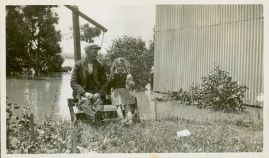
Photograph - Grandfather and granddaughter in the yard of 8 Kellett Grove, Kew, 1934
... ...floods -- north kew...floods -- 1934.... yarra river -- north kew floods -- yarra valley floods -- north kew floods -- 1934 natural disasters -- kew willsmere road Verso: GRANDDAD AND I IN BACKYARD Small sepia snapshot of a grandfather and granddaughter sitting in the backyard of 8 Kellett Grove, North Kew, with the floodwaters stretching behind them. ...North Kew, now divided between Kew and Kew East, bordered the Yarra River. As such, it was a region subject to flooding in the Yarra Valley. Development beyond this point (ie Kellett Grove) was limited by the City of Kew's planning regulations. Prior to urban development, the area since European settlement and the first land sales in the district in the 1840s, had been used for dairy farming. Vivid photograph contrasting domestic life and relationships with natural disasters such as the flood of 1934.Small sepia snapshot of a grandfather and granddaughter sitting in the backyard of 8 Kellett Grove, North Kew, with the floodwaters stretching behind them.Verso: GRANDDAD AND I IN BACKYARDyarra river -- north kew, floods -- yarra valley, floods -- north kew, floods -- 1934, natural disasters -- kew, willsmere road -
 Kew Historical Society Inc
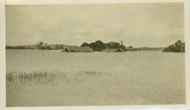
Photograph - Submerged houses in River Avenue, North Kew, 1934
... ...floods -- north kew...floods -- 1934...Small sepia snapshot of two submerged houses belonging to local families in River Avenue, North Kew, during the 1934 floods. The view is presumably from near Kellett Grove looking north towards Fairfield..... yarra river -- north kew floods -- yarra valley floods -- north kew floods -- 1934 natural disasters -- kew Verso: COES & HYATTS ROOF / RIVER AVENUE / Stamped: 6414 Small sepia snapshot of two submerged houses belonging to local families in River Avenue, North Kew, during the 1934 floods. ...North Kew, now divided between Kew and Kew East, bordered the Yarra River. As such, it was a region subject to flooding in the Yarra Valley. Development beyond this point (ie Kellett Grove) was limited by the City of Kew's planning regulations. Prior to urban development, the area since European settlement and the first land sales in the district in the 1840s, had been used for dairy farming. Vivid photograph contrasting domestic life and relationships with natural disasters such as the flood of 1934.Small sepia snapshot of two submerged houses belonging to local families in River Avenue, North Kew, during the 1934 floods. The view is presumably from near Kellett Grove looking north towards Fairfield.Verso: COES & HYATTS ROOF / RIVER AVENUE / Stamped: 6414yarra river -- north kew, floods -- yarra valley, floods -- north kew, floods -- 1934, natural disasters -- kew -
 Kew Historical Society Inc
Photograph - Flooding of the Yarra River in North Kew, 1934
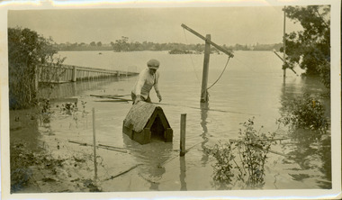
... ...floods -- north kew...floods -- 1934.... yarra river -- north kew floods -- yarra valley floods -- north kew floods -- 1934 natural disasters -- kew Verso: DAD SECURING NIPPY'S DOG KENNEL / Stamped 6414 Small sepia snapshot of the donors grandfather rescuing the family dog's kennel from rising floodwaters at the rear of 8 Kellett Grove, North Kew, . ...North Kew, now divided between Kew and Kew East, bordered the Yarra River. As such, it was a region subject to flooding in the Yarra Valley. Development beyond this point (ie Kellett Grove) was limited by the City of Kew's planning regulations. Prior to urban development, the area since European settlement and the first land sales in the district in the 1840s, had been used for dairy farming. Vivid photograph contrasting domestic life and relationships with natural disasters such as the flood of 1934.Small sepia snapshot of the donors grandfather rescuing the family dog's kennel from rising floodwaters at the rear of 8 Kellett Grove, North Kew, .Verso: DAD SECURING NIPPY'S DOG KENNEL / Stamped 6414yarra river -- north kew, floods -- yarra valley, floods -- north kew, floods -- 1934, natural disasters -- kew -
 Kew Historical Society Inc
Photograph - Flooding of the Yarra River in North Kew, 1934
... ...floods -- north kew...floods -- 1934...Kew East, bordered the Yarra River. As such, it was a region subject to flooding in the Yarra Valley. Development beyond this point (ie Kellett Grove) was limited by the City of Kew's planning regulations. Prior to urban development, the area since European settlement and the first land sales in the district in the 1840s, had been used for dairy farming. . yarra river -- north kew floods -- yarra valley floods -- north kew floods -- 1934 natural disasters -- kew Verso: THE SIDE OF RYANS Small sepia snapshot of a local family's house in what was then River Avenue, North Kew being surrounded by floodwaters. ...North Kew, now divided between Kew and Kew East, bordered the Yarra River. As such, it was a region subject to flooding in the Yarra Valley. Development beyond this point (ie Kellett Grove) was limited by the City of Kew's planning regulations. Prior to urban development, the area since European settlement and the first land sales in the district in the 1840s, had been used for dairy farming. .Small sepia snapshot of a local family's house in what was then River Avenue, North Kew being surrounded by floodwaters.Verso: THE SIDE OF RYANSyarra river -- north kew, floods -- yarra valley, floods -- north kew, floods -- 1934, natural disasters -- kew -
 Kew Historical Society Inc
Photograph - Flooding of the Yarra River in North Kew, 1934
... ...floods -- north kew...floods -- 1934...Kew East, bordered the Yarra River. As such, it was a region subject to flooding in the Yarra Valley. Development beyond this point (ie Kellett Grove) was limited by the City of Kew's planning regulations. Prior to urban development, the area since European settlement and the first land sales in the district in the 1840s, had been used for dairy farming. . yarra river -- north kew floods -- yarra valley floods -- north kew floods -- 1934 natural disasters -- kew Verso: TAKEN FROM OUR STREET JUST SEE A BIT OF RYAN'S FENCE / 1934 Small sepia snapshot of what was then River Avenue, North Kew submerged by floodwaters.The photo was taken in the vicinity of 8 Kellett Grove, North Kew. ...North Kew, now divided between Kew and Kew East, bordered the Yarra River. As such, it was a region subject to flooding in the Yarra Valley. Development beyond this point (ie Kellett Grove) was limited by the City of Kew's planning regulations. Prior to urban development, the area since European settlement and the first land sales in the district in the 1840s, had been used for dairy farming. .Small sepia snapshot of what was then River Avenue, North Kew submerged by floodwaters.The photo was taken in the vicinity of 8 Kellett Grove, North Kew. Verso: TAKEN FROM OUR STREET JUST SEE A BIT OF RYAN'S FENCE / 1934yarra river -- north kew, floods -- yarra valley, floods -- north kew, floods -- 1934, natural disasters -- kew -
 Kew Historical Society Inc
Photograph - Flooding of the Yarra River in North Kew, 1934
... ...floods -- north kew...floods -- 1934...Kew East, bordered the Yarra River. As such, it was a region subject to flooding in the Yarra Valley. Development beyond this point (ie Kellett Grove) was limited by the City of Kew's planning regulations. Prior to urban development, the area since European settlement and the first land sales in the district in the 1840s, had been used for dairy farming. . yarra river -- north kew floods -- yarra valley floods -- north kew floods -- 1934 natural disasters -- kew chipperfields boathouse Verso: THIS IS CHIPPERFIELD'S BOAT SHEDS & COES & WILLIAMS TAKEN FROM OUR STREET / 1934 Small sepia snapshot of the devastation caused by the 1934 flood.The photo was taken in the vicinity of Kellett Grove, North Kew and includes the roof of Chipperfield's Boathouse as well as other local houses. ...North Kew, now divided between Kew and Kew East, bordered the Yarra River. As such, it was a region subject to flooding in the Yarra Valley. Development beyond this point (ie Kellett Grove) was limited by the City of Kew's planning regulations. Prior to urban development, the area since European settlement and the first land sales in the district in the 1840s, had been used for dairy farming. .Small sepia snapshot of the devastation caused by the 1934 flood.The photo was taken in the vicinity of Kellett Grove, North Kew and includes the roof of Chipperfield's Boathouse as well as other local houses.Verso: THIS IS CHIPPERFIELD'S BOAT SHEDS & COES & WILLIAMS TAKEN FROM OUR STREET / 1934yarra river -- north kew, floods -- yarra valley, floods -- north kew, floods -- 1934, natural disasters -- kew, chipperfields boathouse -
 Kew Historical Society Inc
Photograph, Floods in North Kew, 1934
... Kew] suffered considerably. Mr Wade speaks of 80 acres, out of 100 acres of his cultivated paddock, covered by water." Newspapers continued to describe major flooding in Kew in 1863, 1869, 1878, 1880, 1889, 1891, 1916 and 1934. ...Floods in North Kew, 1934. Vicinity of Willsmere Park....floods continue. The Kew Historical Society's pictures and map collections testify to the impact of flooding in the district. They have historical importance in documenting the extent of flooding in the district and its affects on homes, services and recreation. Numerous photographs record flooding throughout the Twentieth Century. floods (kew) Floods in North Kew, 1934 ...Living with natural processes was frequently a challenge to early European settlers and later residents of what was in the 1850s administered by the Borondara Road Board. This was compounded by the area being bounded on three sides by rivers (Yarra River, Koonung Creek and Gardiner's Creek). In 1849, the historian James Bonwick recorded that "our district [Kew] suffered considerably. Mr Wade speaks of 80 acres, out of 100 acres of his cultivated paddock, covered by water." Newspapers continued to describe major flooding in Kew in 1863, 1869, 1878, 1880, 1889, 1891, 1916 and 1934. While the construction of the Upper Yarra dam in 1957 reduced the levels of flowing downstream, local and riverine floods continue.The Kew Historical Society's pictures and map collections testify to the impact of flooding in the district. They have historical importance in documenting the extent of flooding in the district and its affects on homes, services and recreation. Numerous photographs record flooding throughout the Twentieth Century.Floods in North Kew, 1934. Vicinity of Willsmere Park.floods (kew) -
 Kew Historical Society Inc
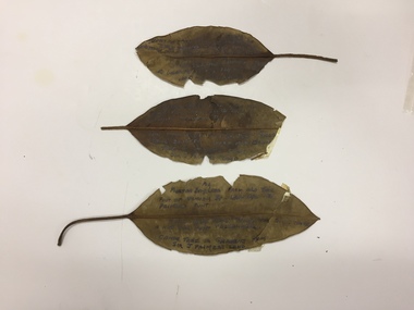
Plant specimen, Dorothy Rogers, Inscribed Moreton Bay Fig Leaves, Hawthorn (Vic), c.1960s
... Kew Historical Society Inc Kew Court House 188 High Street Kew melbourne Collected by the historian Dorothy Rogers denham street - hawthorn (vic) palmer's punt invergowrie - hawthorn 1934 flood - melbourne - hawthorn (vic) 1974.0010.1 "Moreton Bay fig leaf from old tree foot of Derham St Haw - vicinity Palmer's Punt until 1934 flood & hut for Punt passengers was still there. ...Collected by the historian Dorothy RogersDried Moreton Bay fig leaves from the vicinity of Palmer's Punt near Denham Street Hawthorn. Each leaf was inscribed by the historian Dorothy Rogers (sic) before 1973. The leaves are brittle and undated, with the text difficult to decipher. 1974.0010.1 "Moreton Bay fig leaf from old tree foot of Derham St Haw - vicinity Palmer's Punt until 1934 flood & hut for Punt passengers was still there. KH-355." 1974.0010.2 "Moreton Bay fig leaf from old tree foot of Denham St haw - vicinity Palmer's Punt until 1934 flood hut for punt passengers still existed there. A canoe tree in garden from Sir J. Palmer's land. KH-355." 1974.0010.3 "Moreton Bay fig leaf from old tree foot of Denham St leading to Palmer's Punt until 1934 flood there was still there a hut for punt passengers. Canoe tree in gardens from Sir J. Palmer's land. KH-355."denham street - hawthorn (vic), palmer's punt, invergowrie - hawthorn, 1934 flood - melbourne - hawthorn (vic) -
 Kew Historical Society Inc
Photograph, Floods in North Kew, 1971
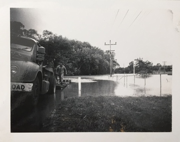
... Kew] suffered considerably. Mr Wade speaks of 80 acres, out of 100 acres of his cultivated paddock, covered by water." Newspapers continued to describe major flooding in Kew in 1863, 1869, 1878, 1880, 1889, 1891, 1916 and 1934. ...Kew] suffered considerably. Mr Wade speaks of 80 acres, out of 100 acres of his cultivated paddock, covered by water." Newspapers continued to describe major flooding in Kew in 1863, 1869, 1878, 1880, 1889, 1891, 1916 and 1934. ...Living with natural processes was frequently a challenge to early European settlers and later residents of what was in the 1850s administered by the Borondara Road Board. This was compounded by the area being bounded on three sides by rivers (Yarra River, Koonung Creek and Gardiner's Creek). In 1849, the historian James Bonwick recorded that "our district [Kew] suffered considerably. Mr Wade speaks of 80 acres, out of 100 acres of his cultivated paddock, covered by water." Newspapers continued to describe major flooding in Kew in 1863, 1869, 1878, 1880, 1889, 1891, 1916 and 1934. While the construction of the Upper Yarra dam in 1957 reduced the levels of flowing downstream, local and riverine floods continue.The Kew Historical Society's pictures and map collections testify to the impact of flooding in the district. They have historical importance in documenting the extent of flooding in the district and its affects on homes, services and recreation. Numerous photographs record flooding throughout the Twentieth Century.Floods in North Kew, 1971. Looking northeast towards Kilby Road from River Avenue. Annotation on reverse: map and date "8 Nov. 71 10.30am".floods (kew), yarra river, kew flood, kilby road flood -
 Kew Historical Society Inc
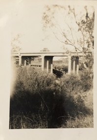
Photograph, Burke Road Bridge, 1930s
... Kew and Ivanhoe. The previous bridge, constructed in 1926 was submerged beneath the flood waters in the 1934 mega-flood of the Yarra....Kew and Ivanhoe. The previous bridge, constructed in 1926 was submerged beneath the flood waters in the 1934 mega-flood of the Yarra. ...Without bridges, Kew remained cut off from the City of Melbourne, only being accessible by Punt. Private and public bridges were constructed from the 1850s, beginning with the Hawthorn Bridge linking Bridge and Burwood Roads. A bridge across the Yarra at Burke Road was created as early as 1873. Since that first wooden bridge, a number of later bridges, typically on concrete pylons have been built, in 1926 and again during the 1970s.Sepia, faded photograph of the Burke Road Bridge linking East Kew and Ivanhoe. The previous bridge, constructed in 1926 was submerged beneath the flood waters in the 1934 mega-flood of the Yarra.burke road bridge (kew), bridges -- river yarra -
 Kew Historical Society Inc
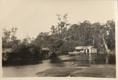
Photograph, Chipperfield's Boat House & Floating Pontoon, 1934
... Kew] suffered considerably. Mr Wade speaks of 80 acres, out of 100 acres of his cultivated paddock, covered by water." Newspapers continued to describe major flooding in Kew in 1863, 1869, 1878, 1880, 1889, 1891, 1916 and 1934. ...Kew] suffered considerably. Mr Wade speaks of 80 acres, out of 100 acres of his cultivated paddock, covered by water." Newspapers continued to describe major flooding in Kew in 1863, 1869, 1878, 1880, 1889, 1891, 1916 and 1934. ...Living with natural processes was frequently a challenge to early European settlers and later residents of what was in the 1850s administered by the Borondara Road Board. This was compounded by the area being bounded on three sides by rivers (Yarra River, Koonung Creek and Gardiner's Creek). In 1849, the historian James Bonwick recorded that "our district [Kew] suffered considerably. Mr Wade speaks of 80 acres, out of 100 acres of his cultivated paddock, covered by water." Newspapers continued to describe major flooding in Kew in 1863, 1869, 1878, 1880, 1889, 1891, 1916 and 1934. While the construction of the Upper Yarra dam in 1957 reduced the levels of flowing downstream, local and riverine floods continue. A number of boat houses operated on both sides of the River Yarra at Kew. Chipperfield's Boat House was located on the Yarra near the corner of Kilby and Willsmere Roads.The Kew Historical Society's pictures and map collections testify to the impact of flooding in the district. They have historical importance in documenting the extent of flooding in the district and its affects on homes, services and recreation. Numerous photographs record flooding throughout the Twentieth Century.Floating pontoon at Chipperfield's Boat House where the canoes were stored, taken in 1934, presumably before the 1934 Flood. This area of the Yarra was shallow with a number of mid river sandbanks and a popular swimming area for locals.yarra river, chipperfield's boathouse, pontoon -
 Kew Historical Society Inc
Photograph, Willsmere Bridge, 1934
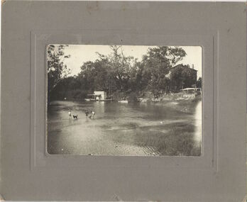
... Kew and Fairfield in the late 19th and early 20th centuries. They included Chipperfield’s ‘Moorings’ and floating pontoon. The substantial two-storey house was named the Moorings, and incorporated an upper storey residence. The Moorings was almost washed away in the 1916 floods, and in 1934...A view of flooded areas in North Kew in the flood of 1934....Together it forms the largest privately-donated collection within the archives of the Kew Historical Society. willsmere flood yarra flood chipperfields chipperfields boathouse north kew Willsmere Bridge. Chipperfields. 1934 ...Several boathouses were built in Kew and Fairfield in the late 19th and early 20th centuries. They included Chipperfield’s ‘Moorings’ and floating pontoon. The substantial two-storey house was named the Moorings, and incorporated an upper storey residence. The Moorings was almost washed away in the 1916 floods, and in 1934 almost totally submerged when the Yarra River rose 26 feet in 14 hours. Following the 1934 flood, the house was restored. The floating pontoon, sometimes referred to as a ‘kiosk’ or ‘canteen’, was used to store canoes. Both were removed in 1972 for the construction of the Eastern Freeway.This work forms part of the collection assembled by the historian Dorothy Rogers, that was donated to the Kew Historical Society by her son John Rogers in 2015. The manuscripts, photographs, maps, and documents were sourced by her from both family and local collections or produced as references for her print publications. Many were directly used by Rogers in writing ‘Lovely Old Homes of Kew’ (1961) and 'A History of Kew' (1973), or the numerous articles on local history that she produced for suburban newspapers. Most of the photographs in the collection include detailed annotations in her hand. The Rogers Collection provides a comprehensive insight into the working habits of a historian in the 1960s and 1970s. Together it forms the largest privately-donated collection within the archives of the Kew Historical Society.A view of flooded areas in North Kew in the flood of 1934.Willsmere Bridge. Chipperfields. 1934 floodwillsmere, flood, yarra flood, chipperfields, chipperfields boathouse, north kew -
 Kew Historical Society Inc
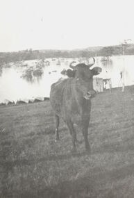
Photograph, Cattle in North Kew floods, 1934
... The year 1934 witnessed the greatest flooding of the Yarra River since settlement. This work forms part of the collection assembled by the historian Dorothy Rogers, that was donated to the Kew Historical Society by her son John Rogers in 2015. ...Photograph of floodwaters encroaching on farm land in North Kew in the flood of 1934....Nth. Kew. 1934 Floods...Kew. 1934 Floods Photograph of floodwaters encroaching on farm land in North Kew in the flood of 1934. ...The year 1934 witnessed the greatest flooding of the Yarra River since settlement. This work forms part of the collection assembled by the historian Dorothy Rogers, that was donated to the Kew Historical Society by her son John Rogers in 2015. The manuscripts, photographs, maps, and documents were sourced by her from both family and local collections or produced as references for her print publications. Many were directly used by Rogers in writing ‘Lovely Old Homes of Kew’ (1961) and 'A History of Kew' (1973), or the numerous articles on local history that she produced for suburban newspapers. Most of the photographs in the collection include detailed annotations in her hand. The Rogers Collection provides a comprehensive insight into the working habits of a historian in the 1960s and 1970s. Together it forms the largest privately-donated collection within the archives of the Kew Historical Society.Photograph of floodwaters encroaching on farm land in North Kew in the flood of 1934.Nth. Kew. 1934 Floodsfloods (melbourne) 1934, dorothy rogers -
 Kew Historical Society Inc
Photograph, Chipperfield's Boat House & Floating Pontoon, c.1939
... Kew and Fairfield in the late 19th and early 20th centuries. They included Chipperfield’s ‘Moorings’ and floating pontoon. The substantial two-storey house was named the Moorings, and incorporated an upper storey residence. The Moorings was almost washed away in the 1916 floods, and in 1934...Together it forms the largest privately-donated collection within the archives of the Kew Historical Society. chipperfield's boat house river yarra dorothy rogers floods 1916, 1934 "Chipperfield's Floating Canteen & house in background. ...Several boathouses were built in Kew and Fairfield in the late 19th and early 20th centuries. They included Chipperfield’s ‘Moorings’ and floating pontoon. The substantial two-storey house was named the Moorings, and incorporated an upper storey residence. The Moorings was almost washed away in the 1916 floods, and in 1934 almost totally submerged when the Yarra River rose 26 feet in 14 hours. Following the 1934 flood, the house was restored. The floating pontoon, sometimes referred to as a ‘kiosk’ or ‘canteen’, was used to store canoes. Both were removed in 1972 for the construction of the Eastern Freeway.This work forms part of the collection assembled by the historian Dorothy Rogers, that was donated to the Kew Historical Society by her son John Rogers in 2015. The manuscripts, photographs, maps, and documents were sourced by her from both family and local collections or produced as references for her print publications. Many were directly used by Rogers in writing ‘Lovely Old Homes of Kew’ (1961) and 'A History of Kew' (1973), or the numerous articles on local history that she produced for suburban newspapers. Most of the photographs in the collection include detailed annotations in her hand. The Rogers Collection provides a comprehensive insight into the working habits of a historian in the 1960s and 1970s. Together it forms the largest privately-donated collection within the archives of the Kew Historical Society.Chipperfield's Floating Canteen (also known as the pontoon) on the Yarra River. at North Kew The children wading in the river are believed to be the three sons of Dorothy Rogers."Chipperfield's Floating Canteen & house in background. At extreme right - observe channel where Connors Creek flows in."chipperfield's boat house, river yarra, dorothy rogers, floods 1916, 1934 -
 Kew Historical Society Inc
Photograph - Photograph (copy), Kanes Bridge, Studley Park, 195-1955
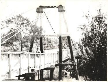
... Kew with the public golf course across the Yarra. The total cost of construction came to 250 pounds and the bridge became known as Kane's Bridge. During the 1934 floods...Kew with the public golf course across the Yarra. The total cost of construction came to 250 pounds and the bridge became known as Kane's Bridge. During the 1934 floods ...In 1928 a footbridge was erected to link Kew with the public golf course across the Yarra. The total cost of construction came to 250 pounds and the bridge became known as Kane's Bridge. During the 1934 floods the bridge was washed downstream, and was subsequently rebuilt. The present form of the bridge resembles the earlier bridge which crossed from the Yarra Bend Asylum to Kew, further upstream. (VHD)This work forms part of the collection assembled by the historian Dorothy Rogers, that was donated to the Kew Historical Society by her son John Rogers in 2015. The manuscripts, photographs, maps, and documents were sourced by her from both family and local collections or produced as references for her print publications. Many were directly used by Rogers in writing ‘Lovely Old Homes of Kew’ (1961) and 'A History of Kew' (1973), or the numerous articles on local history that she produced for suburban newspapers. Most of the photographs in the collection include detailed annotations in her hand. The Rogers Collection provides a comprehensive insight into the working habits of a historian in the 1960s and 1970s. Together it forms the largest privately-donated collection within the archives of the Kew Historical Society.A photographic copy of an older photograph of Kanes Bridge."Kanes Bridge"kanes bridge, yarra river, bridges - kew (vic.)