Showing 36 items matching "floods 1891"
-
 Bacchus Marsh & District Historical Society
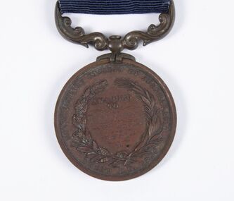
Medal, Royal Humane Society of Australasia Medal Awarded to Thomas Kennedy 3rd August 1891
... ...Floods 1891...Thomas Kennedy aged 14 was awarded this medal in 1892 for the bravery he showed in rescuing members of his family from the flooded Werribee River on the 3rd August 1891. The Bacchus Marsh Express newspaper on for 30 July 1892, page 2, reported the awards ceremony with this description, 'Bronze medals of the Royal Humane Society of Australasia were awarded at the Melbourne Town Hall on Monday evening as follows: Thomas Kennedy, of Maddingley, near Bacchus Marsh, aged 14 years, for the risk he incurred in procuring assistance to rescue his father, mother, four brothers and sisters from being drowned during the flood of the Werribee River, on the 3rd August, 1891. ...He at daybreak swam across a strong current, and procured a boat, then rode a horse attached by a chain to the boat, and was returning thus to the house when he was washed off the horse, and with much difficulty rescued'. Medals Awards Floods 1891 Obverse: Virtute Paratum; Reverse: Awarded to Thomas Kennedy 3rd Aug 1891, Royal Humane Society of Australasia, INSTD. ...Thomas Kennedy aged 14 was awarded this medal in 1892 for the bravery he showed in rescuing members of his family from the flooded Werribee River on the 3rd August 1891. The Bacchus Marsh Express newspaper on for 30 July 1892, page 2, reported the awards ceremony with this description, 'Bronze medals of the Royal Humane Society of Australasia were awarded at the Melbourne Town Hall on Monday evening as follows: Thomas Kennedy, of Maddingley, near Bacchus Marsh, aged 14 years, for the risk he incurred in procuring assistance to rescue his father, mother, four brothers and sisters from being drowned during the flood of the Werribee River, on the 3rd August, 1891. He at daybreak swam across a strong current, and procured a boat, then rode a horse attached by a chain to the boat, and was returning thus to the house when he was washed off the horse, and with much difficulty rescued'. Bronze medal with ribbon.Obverse: Virtute Paratum; Reverse: Awarded to Thomas Kennedy 3rd Aug 1891, Royal Humane Society of Australasia, INSTD. A.D. 1874medals, awards, floods 1891 -
![Studley Park [Toll] Bridge, Kew](/media/collectors/550653872162f11fb04854aa/items/579ebf04d0cdd117c4c0815f/item-media/579ebf3ad0cdd117c4c0953e/item-fit-380x285.jpg?cb=6) Kew Historical Society Inc
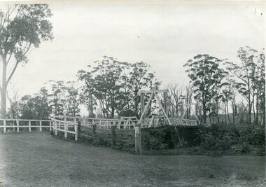
Kew Historical Society IncPhotograph, Studley Park [Toll] Bridge, Kew, 1870s
... Badly damaged by the flood of 1891, the Bridge was compulsorily acquired by the Government in 1899, and later dismantled and sold for firewood....Badly damaged by the flood of 1891, the Bridge was compulsorily acquired by the Government in 1899, and later dismantled and sold for firewood. ...‘Studley Park Bridge’ or ‘penny bridge’ linked Church Street in Abbotsford and what is now Yarra Bend Park. The privately constructed bridge opened in 1857, gaining its popular name from the toll charged at the Abbotsford end. The engineer of the 485ft wide bridge was Mr. Austin and the builder was ‘Mr Grant, who threw the bridge over the Niagara’. Following the opening of Johnston Street Bridge, declining tolls led to the Bridge falling into disrepair. Badly damaged by the flood of 1891, the Bridge was compulsorily acquired by the Government in 1899, and later dismantled and sold for firewood.This work forms part of the collection assembled by the historian Dorothy Rogers, that was donated to the Kew Historical Society by her son John Rogers in 2015. The manuscripts, photographs, maps, and documents were sourced by her from both family and local collections or produced as references for her print publications. Many were directly used by Rogers in writing ‘Lovely Old Homes of Kew’ (1961) and 'A History of Kew' (1973), or the numerous articles on local history that she produced for suburban newspapers. Most of the photographs in the collection include detailed annotations in her hand. The Rogers Collection provides a comprehensive insight into the working habits of a historian in the 1960s and 1970s. Together it forms the largest privately-donated collection within the archives of the Kew Historical Society.A print, taken in the 1960s by Dorothy Rogers, from an original albumen silver photograph now in the collection of the Kew Historical Society. The photograph shows the toll bridge (also known as the Penny Bridge) from the northern end."P[enny] Toll Bridge - built 1857. from old photo"studley park bridge, penny bridge, bridge, timber bridge, toll bridge -
 Orbost & District Historical Society
black and white photograph, August 1897
... The first pile bridge over the Snowy River was just completed by Mr Jim Granter when the 1891 flood took out the centre,. There were differences of opinion as to whether the council should pay . ...The first pile bridge over the Snowy River was just completed by Mr Jim Granter when the 1891 flood took out the centre,. There were differences of opinion as to whether the council should pay . ...This is a photograph of the bridge from the Orbost side. The first pile bridge over the Snowy River was just completed by Mr Jim Granter when the 1891 flood took out the centre,. There were differences of opinion as to whether the council should pay . The Shire Secretary, Mr John Draffin, persuaded them to honour their obligations. Mr Granter and Mr Clarke finished it as a suspension bridge which was opened by Mrs William Watt. Soon after a mob of cattle stampeded, the weight snapped the cable, letting one side sag. Mr R.P. Cameron repaired it and this bridge remained until 1922. "In 1890 the contract for a bridge was let to Mr James Granter for £1450. This structure with additions and improvements made to it was to cost the ratepayers about £2,500, and its erection was proceeded with in a very satisfactory manner until, just as the greater-part of the work had been completed, the flood of 1891 came down on it, piling up mountains of logs, timber and debris against the piers, which had not been made wide enough apart to allow for. contingencies of this kind. The structure held out bravely until the turn of the flood and then gave way with a crash, about five bays from the centre disappearing in the stream." ( Snowy River Mail August 12 1893) This item is a pictorial record of one of the first bridges across the Snowy River in Orbost.A black / white photograph of the old wooden suspension bridge over the Snowy River. There are two copies 919.1 and 919.2. There are two other photos showing the whole bridge taken from further back.on back - "Orbost Bridge...."snowy-river-bridge-orbost granter-james -
 University of Melbourne, Burnley Campus Archives
Plan, School of Primary Agriculture & Horticulture - Burnley, c. 1925-1926
... Lists W.C.s (toilets). Shows 1891 Flood Line. Possibly dates from 1925....Lists W.C.s (toilets). Shows 1891 Flood Line. Possibly dates from 1925. School of Primary Agriculture & Horticulture - Burnley Plan ...Copy of plan photographed at the Public Records Office Victoria. Central Administration Correspondence Files 1912-1939 ITEM. VPRS 10163/P0003/2. Accomodation Burnley School Part 1. Traced from M.M.B.W. Plan No. 42. Scale 160 ft=1 in. Level Datum L.M.N. Hobson's Bay. Traced by C.E.B.W. 16.02.1926. Additional matter in red and green inserted by F.E.T.C. 09.02.1926. Note by J.J. Rae (Principal). Lists W.C.s (toilets). Shows 1891 Flood Line. Possibly dates from 1925.prov, school of primary agriculture and horticulture, burnely, j.j. rae -
 Orbost & District Historical Society
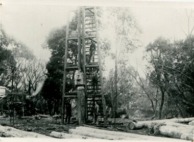
black and white photograph, C1890
... The first pile bridge over the Snowy River was just completed by Mr Jim Granter when the 1891 flood took out the centre,. There were differences of opinion as to whether the council should pay . ...The first pile bridge over the Snowy River was just completed by Mr Jim Granter when the 1891 flood took out the centre,. There were differences of opinion as to whether the council should pay . ...This photograph shows the construction of the first bridge over the Snowy River at Orbost being built. a copy was also donated by Gil and Heather Richardson. The first pile bridge over the Snowy River was just completed by Mr Jim Granter when the 1891 flood took out the centre,. There were differences of opinion as to whether the council should pay . The Shire Secretary, Mr John Draffin, persuaded them to honour their obligations. Mr Granter and Mr Clarke finished it as a suspension bridge which was opened by Mrs William Watt. Soon after a mob of cattle stampeded, the weight snapped the cable, letting one side sag. Mr R.P. Cameron repaired it and this bridge remained until 1922. "In 1890 the contract for a bridge was let to Mr James Granter for £1450. This structure with additions and improvements made to it was to cost the ratepayers about £2,500, and its erection was proceeded with in a very satisfactory manner until, just as the greater-part of the work had been completed, the flood of 1891 came down on it, piling up mountains of logs, timber and debris against the piers, which had not been made wide enough apart to allow for. contingencies of this kind. The structure held out bravely until the turn of the flood and then gave way with a crash, about five bays from the centre disappearing in the stream." ( Snowy River Mail August 12 1893)This is a pictorial record of the construction of the first bridge over the Snowy River.A black / white photograph of four men working on the construction of a new bridge and its pylons a man is standing on a timber tower/ derrick. There are logs in the foreground, trees in the background. sheds on the left and possibly a steam engine.on back - "first bridge - 1st pile being driven"snowy-river-bridge granter-jim bridge -
 Eltham District Historical Society Inc
Film - Video (DVD), Melbourne and Metropolitan Board of Works, Yarra River Conference Proceedings; a Board of Works centenary event, 13-16 April 1991
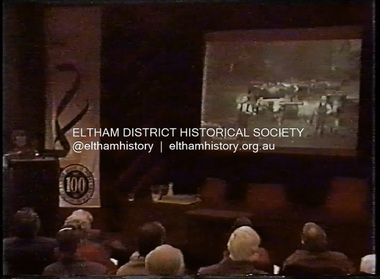
... to Utility Early navigators of the Yarra River; developing the port of Melbourne; the gold rush and its effect on the new colony; punts and bridges; water supply; pollution of the Yarra; the discovery of gold and early settlement of the Yarra valley; floods of 1839 and 1863. 1863-1891 Formation of the Harbour Trust; Coode Canal; pollution of the Yarra by industry; aborigines, gold miners, timber getters in the Upper Yarra areas; bridges; the flood of 1891. ...to Utility Early navigators of the Yarra River; developing the port of Melbourne; the gold rush and its effect on the new colony; punts and bridges; water supply; pollution of the Yarra; the discovery of gold and early settlement of the Yarra valley; floods of 1839 and 1863. 1863-1891 Formation of the Harbour Trust; Coode Canal; pollution of the Yarra by industry; aborigines, gold miners, timber getters in the Upper Yarra areas; bridges; the flood of 1891. ...Yarra River Conference History Segment [Noted on VHS tape jackets "Due to unavoidable circumstances, the quality of these tapes in some setions is less than desired."] The Yarra River Conference, organised by the Board of Works as part of the Centenary Celebrations, was held in the Board's Head Office Theatrette from 13-16 April, 1991. A segment of the Conference focussed on the role that the Yarra River has played in relation to the historical development of Melbourne. Conceived and presented by a group of prominent historians as a chronological 'trip down the river in time', and profusely illustrated with slides, this segment traced the various impacts that urban and rural growth, development of marine commerce, recreational uses, and environmental problems have had on the Yarra during a century and a half of European occupation. As no formal written paper of this combined presentation is available, these two video-tapes provide a record for anyone who has an interest in tis fascinating aspect of the Yarra's history. The speakers who combined to present this segment are identified on the cover of Tape 2. Tape 1 (2 hours) 1838-1863 Deputy ?? to Utility Early navigators of the Yarra River; developing the port of Melbourne; the gold rush and its effect on the new colony; punts and bridges; water supply; pollution of the Yarra; the discovery of gold and early settlement of the Yarra valley; floods of 1839 and 1863. 1863-1891 Formation of the Harbour Trust; Coode Canal; pollution of the Yarra by industry; aborigines, gold miners, timber getters in the Upper Yarra areas; bridges; the flood of 1891. Tape 2 ( 1 1/2 hours) 1892-1934: People Begin to See Beauty and Romance to the River Henley-on-Yarra; realignment of the Yarra; MMBW is responsible for a sewerage system; new docks to cope with increased overseas trade; development of recreational parks; new reservoirs; timber production and timber tramways; bushfire; flood of 1934. 1935-1970: The River is Neglected Still, Except When it Proves Useful Bushfirs of 1939; the end of many sawmills; birth of tourism; increased interest in conservation and preservation of land for open space; further augmentation of water supply system; birth of containerisation changes the port; environmental concerns gain momentum. Speakers Dr Tony Dingle *, Department of Economic History, Monash University Dr Carolyn Rasmussen *, History Consultant Prof. Graeme Davison, History Department, Monash University Mr. Tom Griffiths, Lecturer in Public History, Monash Uiversity Mr. Patrick Miller, History Consultant Mr. Colin Jones, Author and Historian * Co-authors of the Board's history, 'Vital Connections'.video recording, yarra river, conference proceedings -
 Eltham District Historical Society Inc
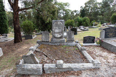
Photograph, Peter Pidgeon, Grave of (Captain) Gordon Watts-Phillips and Mary Hilda Watts-Phillips, Eltham Cemetery, Victoria, 5 April 2021
... An interesting link is established with the heavy floods of August 1891 by the erection of a tombstone in the Eltham cemetery. ...An interesting link is established with the heavy floods of August 1891 by the erection of a tombstone in the Eltham cemetery. ...Charles Gordon Watts-Phillips was born in 1849 at Forest Hill, Surrey, England, the son of Dramatic Author, Watts Phillips, and Lily Mariner. He departed England for Australia around 1874. His sister Roland was a favourite Australian actress of the early 1900s. Gordon as he was known, whilst residing in Goolwa, South Australia and working as a clerk met and married a widow, Jane Luxon (nee Miller) on the 7th August, 1876 at the Wesleyan Church in Strathalbyn, South Australia. Jane, Gordon’s elder by some 11 years was born in Ireland in 1838, the daughter of Robert Joseph Miller, a carpenter and Jane Miller. She had previously married Captain William Luxon in 1861 at Encounter Bay, South Australia at age 22 and they had four children: William (1864), George Robert (1865), Miriam Louisa (1867) and Harriet Jane (1869), all born at Encounter Bay. Gordon and Jane had two further children together: Caroline Roland Watts-Phillips (1877 Islington S.A.) and Charles Gordon Watts-Phillips (1879 Yatala, S.A.). At some stage, Jane then deserted her husband. Gordon obtained a master's certificate and was a part owner of a small trader. He had also been captain of one of the passenger boats on the Darling River. He was reputedly a popular coastal skipper. By 1891 Gordon was the Captain of the S.S Omeo operating around Sale, Victoria. In August of that year some of the heaviest flooding of the Thomson River ever experienced in twenty years occurred over the 3rd and 4th of August. Gordon, and others, rescued the lives of many families over that period for which he was awarded a Bronze Medal by the Royal Humane Society. By 1892 the S.S. Omeo had passed to another Captain and Gordon subsequently retired from the sea and moved to Melbourne. Whilst residing in Coburg, Victoria, Gordon met Mary Hilda Harvey Huxley who was living in Brunswick. Mary was born in Horsham, the daughter of George Harry Huxley, a miner, and Emma Deane. Having not heard from Jane for some years and believing her dead, Gordon and Mary marry at Carlton on Christmas Eve, 1900. Interestingly, an announcement of the marriage was not placed in The Age newspaper until September 1903, nearly three years after the event by which time Gordon and Mary had a son, Victor Gordon Watts-Phillips, born 8 February 1903 in Carlton. Within months of the placement of this marriage announcement, his former wife, Jane, makes a reappearance but apparently does not interfere and Mary and Gordon continue to live together as husband and wife. Around the same time in late 1903, Gordon’s brother, Basil Watts Phillip wrote from London to the Victoria Police seeking assistance to locate his brother. He had last heard from him in a letter dated Cunninghame, Gippsland, 1891. He indicated that about 1893 Gordon and Jane and their two children were living at Beaconsfield Parade, Albert Park but the whereabouts of all was now unknown. He mentioned Gordon had also been awarded 21 guineas by Judge Boucaut on the 26th February 1884, also a silver medal, for arresting two ruffians who had brutally assaulted a jockey (in South Australia) and that he had been awarded the Royal Humane Society's medal, London, and in 1891, was presented with the Royal Humane Society's certificate of merit (Victoria). Basil also stated his brother had lost the sight of one eye through a stab he received in New York and had a scar on his temple, one on the wrist, two under the shoulder blade, and one on the thigh, and two bullet wounds in the leg. Basil’s quest was published in the Melbourne Herald and assistance was soon forthcoming to the Police. In June 1906 Gordon made his Will, leaving all his estate to his youngest son Victor. Mary was appointed Executrix and it was witnessed by Olive Huxley, married woman, and James Huxley, a pottery maker. James was subsequently killed in France in May 1918. Gordon and Mary have a second son, Basil Douglas born in Carlton in 1911 but he dies as toddler in 1913. At some point Gordon and Mary made their home at Eltham though official electoral roll records record them at Little Flinders Street Melbourne, employed as a caretaker and from 1906 in Brunswick as a decorator then painter. Eltham may have been a ‘holiday’ home but it seems Mary was actively engaged in the community as a newspaper report in the Advertiser in 1922 not long after Gordon’s death indicates Mary was one of the best known and best liked ladies of the Eltham district. She was actively engaged in all matters, tending towards the welfare of the district. At the time of Gordon’s death Mary was president of the Ladies' Public Hall Committee, responsible for the conduct of numerous, and successful entertainments. Gordon’s first and only legal wife, Jane Luxon Watts-Phillips nee Miller, died 6 November 1921 and was buried 8 November 1921 at Springvale Cemetery. Jane had lived 34 years in South Australia and 30 years in Victoria. With Jane now dead, Gordon was now officially a widower and just three weeks later, the retired master mariner of Eltham at age 55 remarried Mary, 42, of 174 Hickford Street, East Brunswick on the 29th November 1921 in the Parish of St Cuthbert, East Brunswick. Gordon died at their home, ‘The Rest’, at 174 Hickford Street, East Brunswick on February 9, 1922 and was buried at Eltham Cemetery on February 11. An interesting link is established with the heavy floods of August 1891 by the erection of a tombstone in the Eltham cemetery. The stone bears the inscription: - “In loving memory of (Captain) Gordon, dearly beloved husband of Mary Watts Phillips. Died 9th February 1922, aged 62 years." Beside the stone is a replica, carved in a marble scroll, of the Royal Humane Society of Australia's Certificate of merit. Part of the wording of this certificate is as follows:- “At a general court of directors holder at the offices of the society at Melbourne on the 6th day of September 1891, it was resolved that the courage and humanity displayed by Gordon Watts Phillips aged 30-years captain of S.S. Omeo, Sale, in rescuing many families from drowning during the heavy floods on Thomson River on 3rd and 4th of August 1891 call for the admiration of the court, and justly entitles him to the certificate of merit of this society, which is hereby awarded." Unbeknownst to Gordon, his second and subsequent legal marriage to Mary initiated a revocation of his Will of 1906, which had solely benefited his son Victor. Consequently, Mary had to apply for Letters of Administration and the only legal beneficiaries would be Mary and his two children by Jane. On June 18, 1940, at age 61, Mary married 70-year-old Arthur Ernest Fenn in Melbourne. Unfortunately for her, Arthur died a year later in July 1941 and was buried in the Cohuna Cemetery near Echuca. Mary lived a further 8 years, passing away suddenly July 4, 1948 in Carlton, and was buried July 7 with her beloved husband Gordon, at Eltham Cemetery. In Loving Memory of (Captain) Gordon Dearly beloved husbandof Mary Watts-Phillips Died 9th Feb. 1922, aged 62 years Also Mary Hilda Loved wife of above Died 4th July 1948 "At rest"Born Digitaleltham cemetery, gravestones, (captain) gordon watts-phillips, mary hilda harvey watts-phillips (nee huxley) -
 Eltham District Historical Society Inc
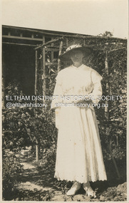
Photograph, Ellen Sweeney in Mrs Cox's garden, Eltham, Easter Sunday, April 16, 1922
... flood twice and people who lived along its banks had to move. I believe the Eltham PS is greatly improved. Betty says I shall get lost there now. Casterton is on the Glenelg R. in Vic so you will remember that next time. Best wishes to you all. From E. Hooley Ellen Sweeney was a former student of Eltham State School in the 1880s, She became a teacher at the school from 1891...flood twice and people who lived along its banks had to move. I believe the Eltham PS is greatly improved. Betty says I shall get lost there now. Casterton is on the Glenelg R. in Vic so you will remember that next time. Best wishes to you all. From E. Hooley Ellen Sweeney was a former student of Eltham State School in the 1880s, She became a teacher at the school from 1891 ...Jackson St Casterton Aug 18. 23 Dear Girls, I was very pleased to receive your nice letters with news of your doings in Eltham. You put Casterton S.A., so your letters were a long time reaching me. As I hope to see you all very soon I shall just send a p.c. of me taken in Mrs Cox’s garden Easter Sunday 12 months ago. The river here has been in flood twice and people who lived along its banks had to move. I believe the Eltham PS is greatly improved. Betty says I shall get lost there now. Casterton is on the Glenelg R. in Vic so you will remember that next time. Best wishes to you all. From E. Hooley Ellen Sweeney was a former student of Eltham State School in the 1880s, She became a teacher at the school from 1891-1898. She returned in 1915 until her marriage to William Hooley of Casterton at St Marys, Eltham, Tuesday, April 24, 1923. Wedding at Eltham. (1923, April 27). Advertiser (Hurstbridge, Vic. : 1922 - 1939), p. 2 (AFTERNOON). Retrieved February 14, 2023, from http://nla.gov.au/nla.news-article56655781 Wedding at Eltham PRESENTATIONS TO MISS SWEENEY. On Tuesday last. Miss Sweeney (a member of an old and respected Eltham family), who recently resigned her position as assistant teacher at the Eltham State School to marry Mr. W. Hooley, of Casterton, was presented with a handsome gold wristlet watch. The headmaster, Mr. Dudtield, in making the presentation on behalf of the school committee, parents, and children paid a high tribute to the excellent work done by Miss Sweeney during her connection with the school, and in asking her acceptance of the present, expressed on behalf of all the fullest measure of happiness to Miss Sweeney in her married life. On Thursday evening, a social evening was tendered to Miss Sweeney, at Mrs. T. Jewell's residence Main street, by the choir and parishioners of St. Mary's Church, Eltham, where Miss Sweeney has for some years acted as choir mistress. Mr. Harold Cox, in handing her a handsome gold and oak silver salad bowl and service, expressed the heartiest good wishes to one who had not only labored so strenuously in organising the choir, but had been always foremost in promoting church and public movements in the community. Congratulatory addresses were also contributed by the Rev. F. Norris and Mr. W. P. McMahon. Miss Sweeney sincerely thanked the donors for their beautiful present, and the speakers for the many kind things said in her regard. She felt very much severing her connection with Eltham. She would carry away many happy-. recollections of her old home, and the kindly people of the town. She hoped after some years to return to Eltham. permanently. (Applause.) On Saturday morning. the marriage ceremony was performed at St. Mary's in the presence of a large number of friends. During the nuptial Mass, celebrated by the Rev. F. Parker. (North Fitzroy), assisted-by the Rev. F. Morris .(Eltham). The choral part of the service including the Wedding March, was very efficiently rendered by the choir. MRS HOOLEY (1940, May 10).Eltham and Whittlesea Shires Advertiser (Vic. : 1940 - 1942), p. 4. Retrieved February 14, 2023, from http://nla.gov.au/nla.news-article57491650 MRS HOOLEY Sincere regret was felt, in Eltham and district at the death of Mrs. W. Hooley (nee Miss Ellen Sweeney) a very dear and capable teacher at State Schools in Eltham and other districts, including the Western District. The deceased was one of Nature's ladies, and was a native of Eltham having been born in the historic home, Culla Hill, one of the first settlements on the Yarra. She passed peacefully away on Anzac Day, April 26. The. funeral was the largest and most impressive ever seen in Eltham, and left St. Mary's Church after a requiem mass conducted by Rev. Father Morrison and Father Hollis. The pall bearers were mostly girlhood friends. Deceased leaves a husband, two brothers, Mr. Tom Sweeney of Kew, and Mr. Frank Sweeney of Western Australia and sisters (Mrs. Lane, of W.A., and Mrs. M. Carringham, of Dalton St, Eltham.) POSTCARD 1905-1940s Like the carte-de-visite, postcards enjoyed a collecting craze by large numbers of people, and were often kept in albums through which the interested visitor could browse. Postcards were posted or exchanged in huge numbers. Postal authorities in Australia only allowed the private printing of postcards from 1898. At this time the back of the card was reserved for the address and postage stamp, and the front was used for the message and a picture. In 1902 British authorities allowed a "divided back", so that the left side could be used for the message, the right side for the address and stamp, and the whole of the front was devoted to the picture. France followed suit in 1904, Germany and Australia in 1905, and the United States in 1907. - Frost, Lenore; Dating Family Photos 1850-1920; Valiant Press Pty. Ltd., Berwick, Victoria 1991marg ball collection, postcard, 1922, 1923, ellen hooley (nee sweeney), ellen sweeney, eltham, mrs cox -
 Orbost & District Historical Society
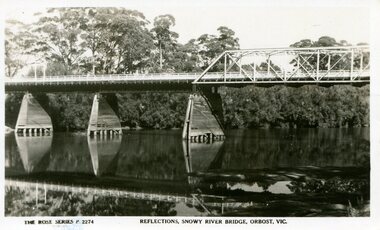
postcard, C1920-1940
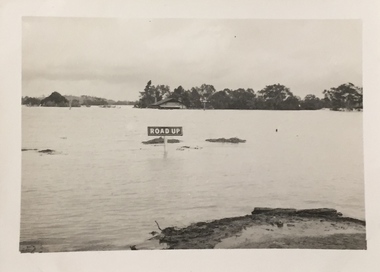
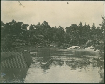
... The first, in 1891, lasted just two years before it succumbed to flood waters. The bridge in this photograph was built in the 1920s as a road and rail bridge, and was again partly washed away by flood waters in 1934. ...The first, in 1891, lasted just two years before it succumbed to flood waters. The bridge in this photograph was built in the 1920s as a road and rail bridge, and was again partly washed away by flood waters in 1934. ...This photograph shows the second major bridge across the Snowy River at Orbost. The current Snowy River bridge is the fourth to provide a crossing to the township of Orbost. The first, in 1891, lasted just two years before it succumbed to flood waters. The bridge in this photograph was built in the 1920s as a road and rail bridge, and was again partly washed away by flood waters in 1934. After the end of the first World War the Victorian Railways considered an extension of the railhead across the river at Orbost, and in 1922 a new timber and steel girder structure, a joint Country Roads Board — Victorian Railways venture, was built and completed at a cost of £41,000 (the steel girders came from the Flinders Street viaduct reconstruction). Subsequently it was decided not to take the railway across the river, and the bridge was only used by road traffic. It was severely battered by floods during its life. and after the 1971 floods was eventually replaced by the current bridge in 1975. (info from Newletter 54N by John Phillips) This item is an early pictorial record of the previous Snowy River bridge at Orbost.A postcard with a black / white photograph of a bridge - timber and steel girder structure - across the Snowy River at Orbost, Reflections of the bridge are seen in the water.snowy-river-bridge-orbost -
 Orbost & District Historical Society
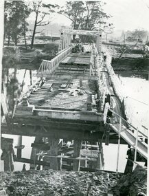
black and white photograph, 1971
... The first, in 1891, lasted just two years before it succumbed to flood waters. The bridge in this photograph was built in the 1920s as a road and rail bridge, and was again partly washed away by flood waters in 1934. ...The first, in 1891, lasted just two years before it succumbed to flood waters. The bridge in this photograph was built in the 1920s as a road and rail bridge, and was again partly washed away by flood waters in 1934. ...This photograph shows the second major bridge across the Snowy River at Orbost. The current Snowy River bridge is the fourth to provide a crossing to the township of Orbost. The first, in 1891, lasted just two years before it succumbed to flood waters. The bridge in this photograph was built in the 1920s as a road and rail bridge, and was again partly washed away by flood waters in 1934. After the end of the first World War the Victorian Railways considered an extension of the railhead across the river at Orbost, and in 1922 a new timber and steel girder structure, a joint Country Roads Board — Victorian Railways venture, was built and completed at a cost of £41,000 (the steel girders came from the Flinders Street viaduct reconstruction). Subsequently it was decided not to take the railway across the river, and the bridge was only used by road traffic. It was severely battered by floods during its life. and after the devastating 1971 floods was eventually replaced by the current bridge in 1975. (info from Newletter 54N by John Phillips)This is a pictorial record of the flood damage in 1971 when part of the Snowy River Bridge was washed away.A black / white photograph of a bridge which has been damaged by floodwaters. It shows one end has been washed away.orbost-snowy-river-bridge-1971 floods-orbost-1971 -
 Kew Historical Society Inc
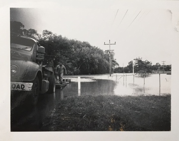
Photograph, Floods in North Kew, 1971
... Newspapers continued to describe major flooding in Kew in 1863, 1869, 1878, 1880, 1889, 1891, 1916 and 1934. ...Newspapers continued to describe major flooding in Kew in 1863, 1869, 1878, 1880, 1889, 1891, 1916 and 1934. ...Living with natural processes was frequently a challenge to early European settlers and later residents of what was in the 1850s administered by the Borondara Road Board. This was compounded by the area being bounded on three sides by rivers (Yarra River, Koonung Creek and Gardiner's Creek). In 1849, the historian James Bonwick recorded that "our district [Kew] suffered considerably. Mr Wade speaks of 80 acres, out of 100 acres of his cultivated paddock, covered by water." Newspapers continued to describe major flooding in Kew in 1863, 1869, 1878, 1880, 1889, 1891, 1916 and 1934. While the construction of the Upper Yarra dam in 1957 reduced the levels of flowing downstream, local and riverine floods continue.The Kew Historical Society's pictures and map collections testify to the impact of flooding in the district. They have historical importance in documenting the extent of flooding in the district and its affects on homes, services and recreation. Numerous photographs record flooding throughout the Twentieth Century.Floods in North Kew, 1971. Looking northeast towards Kilby Road from River Avenue. Annotation on reverse: map and date "8 Nov. 71 10.30am".floods (kew), yarra river, kew flood, kilby road flood -
 Kew Historical Society Inc
Photograph, Floods in North Kew, 1934
... Newspapers continued to describe major flooding in Kew in 1863, 1869, 1878, 1880, 1889, 1891, 1916 and 1934. ...Newspapers continued to describe major flooding in Kew in 1863, 1869, 1878, 1880, 1889, 1891, 1916 and 1934. ...Living with natural processes was frequently a challenge to early European settlers and later residents of what was in the 1850s administered by the Borondara Road Board. This was compounded by the area being bounded on three sides by rivers (Yarra River, Koonung Creek and Gardiner's Creek). In 1849, the historian James Bonwick recorded that "our district [Kew] suffered considerably. Mr Wade speaks of 80 acres, out of 100 acres of his cultivated paddock, covered by water." Newspapers continued to describe major flooding in Kew in 1863, 1869, 1878, 1880, 1889, 1891, 1916 and 1934. While the construction of the Upper Yarra dam in 1957 reduced the levels of flowing downstream, local and riverine floods continue.The Kew Historical Society's pictures and map collections testify to the impact of flooding in the district. They have historical importance in documenting the extent of flooding in the district and its affects on homes, services and recreation. Numerous photographs record flooding throughout the Twentieth Century.Floods in North Kew, 1934. Vicinity of Willsmere Park.floods (kew) -
![Flooding at Chipperfield's Boathouse [East Kew], 1934](/media/collectors/550653872162f11fb04854aa/items/58cbaad5d0cec425b474bfb1/item-media/58cf6fbdd0cf9f331490feb0/item-fit-380x285.jpg?cb=6) Kew Historical Society Inc
Kew Historical Society IncPhotograph, Flooding at Chipperfield's Boathouse, 1934
... Newspapers continued to describe major flooding in Kew in 1863, 1869, 1878, 1880, 1889, 1891, 1916 and 1934. ...Newspapers continued to describe major flooding in Kew in 1863, 1869, 1878, 1880, 1889, 1891, 1916 and 1934. ...Living with natural processes was frequently a challenge to early European settlers and later residents of what was in the 1850s administered by the Borondara Road Board. This was compounded by the area being bounded on three sides by rivers (Yarra River, Koonung Creek and Gardiner's Creek). In 1849, the historian James Bonwick recorded that "our district [Kew] suffered considerably. Mr Wade speaks of 80 acres, out of 100 acres of his cultivated paddock, covered by water." Newspapers continued to describe major flooding in Kew in 1863, 1869, 1878, 1880, 1889, 1891, 1916 and 1934. While the construction of the Upper Yarra dam in 1957 reduced the levels of flowing downstream, local and riverine floods continue.The Kew Historical Society's pictures and map collections testify to the impact of flooding in the district. They have historical importance in documenting the extent of flooding in the district and its affects on homes, services and recreation. Numerous photographs record flooding throughout the Twentieth Century.Floods in North Kew, 1934. Chipperfield's Boathouse and the adding Moorings was located beside the Yarra River near the corner of Willsmere and Kilby Roads. The flood reached the roof of the Moorings, which can be seen in the photo.floods (kew), floods (kew) 1934, yarra river -
 Kew Historical Society Inc
Photograph, Floods in North Kew, 1934
... Newspapers continued to describe major flooding in Kew in 1863, 1869, 1878, 1880, 1889, 1891, 1916 and 1934. ...Newspapers continued to describe major flooding in Kew in 1863, 1869, 1878, 1880, 1889, 1891, 1916 and 1934. ...Living with natural processes was frequently a challenge to early European settlers and later residents of what was in the 1850s administered by the Borondara Road Board. This was compounded by the area being bounded on three sides by rivers (Yarra River, Koonung Creek and Gardiner's Creek). In 1849, the historian James Bonwick recorded that "our district [Kew] suffered considerably. Mr Wade speaks of 80 acres, out of 100 acres of his cultivated paddock, covered by water." Newspapers continued to describe major flooding in Kew in 1863, 1869, 1878, 1880, 1889, 1891, 1916 and 1934. While the construction of the Upper Yarra dam in 1957 reduced the levels of flowing downstream, local and riverine floods continue.The Kew Historical Society's pictures and map collections testify to the impact of flooding in the district. They have historical importance in documenting the extent of flooding in the district and its affects on homes, services and recreation. Numerous photographs record flooding throughout the Twentieth Century.Floods in North Kew, 1934. Unidentified location on the Yarra Flood Plain at Kew.floods (kew) 1934, yarra river -
 Kew Historical Society Inc
Photograph, Floods in North Kew, 1934
... Newspapers continued to describe major flooding in Kew in 1863, 1869, 1878, 1880, 1889, 1891, 1916 and 1934. ...Newspapers continued to describe major flooding in Kew in 1863, 1869, 1878, 1880, 1889, 1891, 1916 and 1934. ...Living with natural processes was frequently a challenge to early European settlers and later residents of what was in the 1850s administered by the Borondara Road Board. This was compounded by the area being bounded on three sides by rivers (Yarra River, Koonung Creek and Gardiner's Creek). In 1849, the historian James Bonwick recorded that "our district [Kew] suffered considerably. Mr Wade speaks of 80 acres, out of 100 acres of his cultivated paddock, covered by water." Newspapers continued to describe major flooding in Kew in 1863, 1869, 1878, 1880, 1889, 1891, 1916 and 1934. While the construction of the Upper Yarra dam in 1957 reduced the levels of flowing downstream, local and riverine floods continue.The Kew Historical Society's pictures and map collections testify to the impact of flooding in the district. They have historical importance in documenting the extent of flooding in the district and its affects on homes, services and recreation. Numerous photographs record flooding throughout the Twentieth Century.Floods in North Kew, 1934. Chipperfield's Boat House under flood.floods (kew) 1934, yarra river, chipperfield's boat house -
 Kew Historical Society Inc
Photograph, Floods in North Kew, 1934
... Newspapers continued to describe major flooding in Kew in 1863, 1869, 1878, 1880, 1889, 1891, 1916 and 1934. ...Newspapers continued to describe major flooding in Kew in 1863, 1869, 1878, 1880, 1889, 1891, 1916 and 1934. ...Living with natural processes was frequently a challenge to early European settlers and later residents of what was in the 1850s administered by the Borondara Road Board. This was compounded by the area being bounded on three sides by rivers (Yarra River, Koonung Creek and Gardiner's Creek). In 1849, the historian James Bonwick recorded that "our district [Kew] suffered considerably. Mr Wade speaks of 80 acres, out of 100 acres of his cultivated paddock, covered by water." Newspapers continued to describe major flooding in Kew in 1863, 1869, 1878, 1880, 1889, 1891, 1916 and 1934. While the construction of the Upper Yarra dam in 1957 reduced the levels of flowing downstream, local and riverine floods continue.The Kew Historical Society's pictures and map collections testify to the impact of flooding in the district. They have historical importance in documenting the extent of flooding in the district and its affects on homes, services and recreation. Numerous photographs record flooding throughout the Twentieth Century.Floods in North Kew, 1934. Flood near the lagoon (Billabong?)floods (kew) 1934, yarra river -
 Kew Historical Society Inc
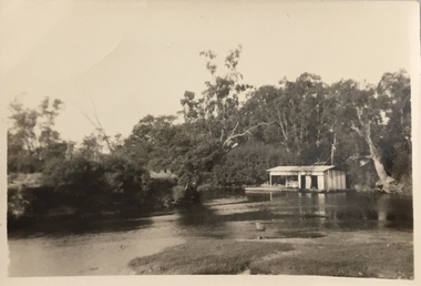
Photograph, Chipperfield's Boat House & Floating Pontoon, 1934
... Newspapers continued to describe major flooding in Kew in 1863, 1869, 1878, 1880, 1889, 1891, 1916 and 1934. ...Newspapers continued to describe major flooding in Kew in 1863, 1869, 1878, 1880, 1889, 1891, 1916 and 1934. ...Living with natural processes was frequently a challenge to early European settlers and later residents of what was in the 1850s administered by the Borondara Road Board. This was compounded by the area being bounded on three sides by rivers (Yarra River, Koonung Creek and Gardiner's Creek). In 1849, the historian James Bonwick recorded that "our district [Kew] suffered considerably. Mr Wade speaks of 80 acres, out of 100 acres of his cultivated paddock, covered by water." Newspapers continued to describe major flooding in Kew in 1863, 1869, 1878, 1880, 1889, 1891, 1916 and 1934. While the construction of the Upper Yarra dam in 1957 reduced the levels of flowing downstream, local and riverine floods continue. A number of boat houses operated on both sides of the River Yarra at Kew. Chipperfield's Boat House was located on the Yarra near the corner of Kilby and Willsmere Roads.The Kew Historical Society's pictures and map collections testify to the impact of flooding in the district. They have historical importance in documenting the extent of flooding in the district and its affects on homes, services and recreation. Numerous photographs record flooding throughout the Twentieth Century.Floating pontoon at Chipperfield's Boat House where the canoes were stored, taken in 1934, presumably before the 1934 Flood. This area of the Yarra was shallow with a number of mid river sandbanks and a popular swimming area for locals.yarra river, chipperfield's boathouse, pontoon -
 Wodonga & District Historical Society Inc
Album - Ringer's River by Des Martin - Plate 1 - Sean O'Day, Horse Breaker at "Gooloora" discusses his future
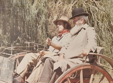
... On a summer's day in 1891 Sean O'Day, Horse Breaker on James MacLough's "Gooloora" Station, is driving the Scots pastoralist in to the railhead at Overton after his annual inspection of that property. Silent and mature for his age, Sean was born in a dray while it was crossing the river during a flood, and has remained at home in it. ...Wodonga & District Historical Society Inc Hut 97, Bonegilla Migrant Experience, 132 Bonegilla Road Bonegilla the-murray On a summer's day in 1891 Sean O'Day, Horse Breaker on James MacLough's "Gooloora" Station, is driving the Scots pastoralist in to the railhead at Overton after his annual inspection of that property. Silent and mature for his age, Sean was born in a dray while it was crossing the river during a flood, and has remained at home in it. ...On a summer's day in 1891 Sean O'Day, Horse Breaker on James MacLough's "Gooloora" Station, is driving the Scots pastoralist in to the railhead at Overton after his annual inspection of that property. Silent and mature for his age, Sean was born in a dray while it was crossing the river during a flood, and has remained at home in it. Because he is always moving by dawn he is known in the borderland as Daylight O'Day. When MacLough asks him what he will be doing on the morrow O'Day replies that he will be manager. Questioned, he suggests that MacLough realises the background to his joke in that the station hands will, that night, celebrate the passing of the Boss's inspection. As they will have hangovers tomorrow all the work will naturally fall to himself, a teetotaller. MacLough nods assent, but, instead of leaving on the train, books a room for the night and a livery gig for the morrow, and drives himself to Gooloora early next morning. D.J. Martin as O'Day, H.S. Diffey as MacLough.The album and images are significant because they document literature written by a prominent member of the Wodonga community. The presentation of this precis was supported by several significant district families and individuals.Ringer's River Album Coloured photo Plate 1des martin, many a mile, ringer's river, northeast victoria stories -
 Wodonga & District Historical Society Inc
Education kit - How do towns change? - Tallangatta, SHEP Project, 1979
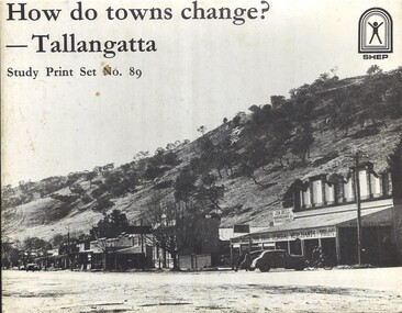
... 1891, doubling the population within a decade. A mile-long viaduct took two years to complete. The railway brought jobs and connected local mining and farming industries to broader markets. From 1918, Tallangatta's future was uncertain. Plans for a reservoir at the confluence of the Mitta Mitta and Murray Rivers threatened the town. Stage one of Lake Hume was completed in 1936, sparing the town temporarily. After WWII, demand for irrigation water rose—and residents were told the town would be flooded ...The Tallangatta pastoral run was established in 1838. By the 1850s a thriving town had been established near the junction of the Mitta Mitta River and Tallangatta Creek. Officially named in 1854, Tallangatta became a vital gateway to nearby goldfields such as Mount Wills, Mitta Mitta, and Cravensville. It also grew as a service centre to the pastoralists in the surrounding area. Rail reached Tallangatta in 1891, doubling the population within a decade. A mile-long viaduct took two years to complete. The railway brought jobs and connected local mining and farming industries to broader markets. From 1918, Tallangatta's future was uncertain. Plans for a reservoir at the confluence of the Mitta Mitta and Murray Rivers threatened the town. Stage one of Lake Hume was completed in 1936, sparing the town temporarily. After WWII, demand for irrigation water rose—and residents were told the town would be flooded. Between 1952 and 1958, Tallangatta was relocated. The State Rivers and Water Supply Commission oversaw the move with a £3 million budget. Over 100 timber homes were relocated, 37 brick homes rebuilt, and 74 prefabricated houses brought in. Thirty-five new buildings were added, including hotels, banks, a butter factory, a hospital, and a modern shopping centre. The new town of Tallangatta was officially reopened by Governor Sir William Slim on June 29, 1956. In 2016, Tallangatta was designated a "Notable Town" by the National Trust for its architectural and historical significance, making it the second town to receive this honour.A set of 89 Photographs, maps and information sheets produced as a case study of the moving of the town of Tallangatta in the 1950s. It was created as a resource to enable secondary school students to investigate how towns can change over time. non-fictionThe Tallangatta pastoral run was established in 1838. By the 1850s a thriving town had been established near the junction of the Mitta Mitta River and Tallangatta Creek. Officially named in 1854, Tallangatta became a vital gateway to nearby goldfields such as Mount Wills, Mitta Mitta, and Cravensville. It also grew as a service centre to the pastoralists in the surrounding area. Rail reached Tallangatta in 1891, doubling the population within a decade. A mile-long viaduct took two years to complete. The railway brought jobs and connected local mining and farming industries to broader markets. From 1918, Tallangatta's future was uncertain. Plans for a reservoir at the confluence of the Mitta Mitta and Murray Rivers threatened the town. Stage one of Lake Hume was completed in 1936, sparing the town temporarily. After WWII, demand for irrigation water rose—and residents were told the town would be flooded. Between 1952 and 1958, Tallangatta was relocated. The State Rivers and Water Supply Commission oversaw the move with a £3 million budget. Over 100 timber homes were relocated, 37 brick homes rebuilt, and 74 prefabricated houses brought in. Thirty-five new buildings were added, including hotels, banks, a butter factory, a hospital, and a modern shopping centre. The new town of Tallangatta was officially reopened by Governor Sir William Slim on June 29, 1956. In 2016, Tallangatta was designated a "Notable Town" by the National Trust for its architectural and historical significance, making it the second town to receive this honour.moving tallangatta, tallangatta - the town that moved, history tallangatta -
 Kew Historical Society Inc
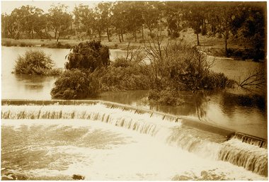
Photograph, J F C Farquhar, Dight's Falls, 1891
... 1891. Farquhar’s photograph of the man-made weir obscures the industrial activity on both sides of the Falls and focusses solely on the river and the surrounding natural vegetation. The photograph probably predates the disastrous flooding...1891. Farquhar’s photograph of the man-made weir obscures the industrial activity on both sides of the Falls and focusses solely on the river and the surrounding natural vegetation. The photograph probably predates the disastrous flooding ...At the beginning of the 1890s, the Kew businessman and Town Councillor, Henry Kellett, commissioned J.F.C. Farquhar to photograph scenes of Kew. These scenes included panoramas as well as pastoral scenes. The resulting set of twelve photographs was assembled in an album, Kew Where We Live, from which customers could select images for purchase.The preamble to the album describes that the photographs used the ‘argentic bromide’ process, now more commonly known as the gelatine silver process. This form of dry plate photography allowed for the negatives to be kept for weeks before processing, hence its value in landscape photography. The resulting images were considered to be finely grained and everlasting. Evidence of the success of Henry Kellett’s venture can be seen today, in that some of the photographs are held in national collections.It is believed that the Kew Historical Society’s copy of the Kellett album is unique and that the photographs in the book were the first copies taken from the original plates. It is the first and most important series of images produced about Kew. The individual images have proved essential in identifying buildings and places of heritage value in the district.Dight’s Falls in Studley Park is an artificial weir built on a natural rock bar across the Yarra. The weir was built in the 1840s to provide water to the ‘Ceres’ flour mill, one of the earliest industrial sites in Melbourne. The falls were later to be named after the owner of this mill. In 1888, William Guilfoyle, Director of the Melbourne Botanical Gardens had called for fresh water to be piped from above the weir to the Botanical Gardens, using a pumping station on the Kew side of the Falls, a holding reservoir in Walmer Street and a series of pipes from there to the Gardens. This system was opened in May 1891. Farquhar’s photograph of the man-made weir obscures the industrial activity on both sides of the Falls and focusses solely on the river and the surrounding natural vegetation. The photograph probably predates the disastrous flooding of the Yarra River in July 1891, the greatest to have occurred in the Colony since the foundation of Melbourne.Dight's Fallskew illustrated, kew where we live, photographic books, henry kellett, yarra river -
University of Melbourne, Burnley Campus Archives
Newspaper - Newspaper Cutting, The Leader, Horticultural Notes, 1891
... Copy of article in "The Leader" (Melbourne) on 18 July, 1891 p14. Description of damage the recent flood had done to the Horticultural Gardens. ...University of Melbourne, Burnley Campus Archives 500 Yarra Boulevard Richmond melbourne the leader horticultural gardens flood damage to gardens Copy of article in "The Leader" (Melbourne) on 18 July, 1891 p14. ...Copy of article in "The Leader" (Melbourne) on 18 July, 1891 p14. Description of damage the recent flood had done to the Horticultural Gardens. Deemed to have done more damage than the 1863 flood.the leader, horticultural gardens, flood, damage to gardens -
University of Melbourne, Burnley Campus Archives
Newspaper - Newspaper Cutting, The Leader, Horticultural Notes, 1891
... 1891 p 14. Descriptions of members of the Board of Advice for the School of Horticulture and curriculum. Discussion about what to do to prevent further flood damage such as a breakwater. ...University of Melbourne, Burnley Campus Archives 500 Yarra Boulevard Richmond melbourne the leader mr neilson curator apple trees school of horticulture floods board of advice flood damage Copy of article in "The Leader" (Melbourne) on 22 August, 1891 p 14. ...Copy of article in "The Leader" (Melbourne) on 22 August, 1891 p 14. Descriptions of members of the Board of Advice for the School of Horticulture and curriculum. Discussion about what to do to prevent further flood damage such as a breakwater. Mr Neilson, curator, has managed to save the young apple trees.the leader, mr neilson, curator, apple trees, school of horticulture, floods, board of advice, flood damage -
 Kew Historical Society Inc
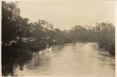
Photograph - Yarra in Flood from Willsmere, North Kew, 1923
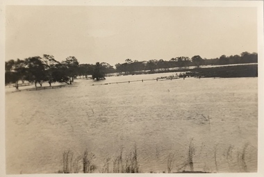
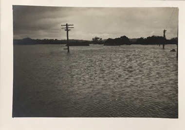
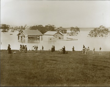
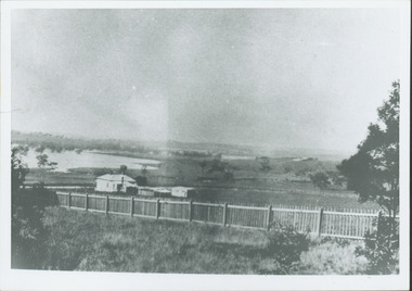
... Extreme flood events of the Yarra River are recorded to have occurred in 1891, 1901, 1916, 1923 and 1934. ...Extreme flood events of the Yarra River are recorded to have occurred in 1891, 1901, 1916, 1923 and 1934. ...Flooding of the Yarra Valley, including that section of the Yarra bordering Kew and Kew East in the north and west of the municipality, was a regular occurrence. Extreme flood events of the Yarra River are recorded to have occurred in 1891, 1901, 1916, 1923 and 1934. The Municipality of Kew's response to these floods was to enact planning decisions restricting residential development in flood prone areas following the floods of 1916, 1921, and 1934. While floods continued after the development of the Upper Yarra Reservoir (construction 1948-57), the regularity and extent of these inundations diminished. Original, large sepia photograph showing men, women and children who have gathered on a grassy verge, probably farm land, to look out across the flooded Yarra Valley at Willsmere, North Kew. In the medium distance are three houses that are largely submerged by the flood waters as well as a number of Eucalypts. Inscribed reverse: "Gift of Kerrie Woollard (KCC) (P)C.1923yarra river valley, kew east (vic.), floods, willsmere -
 Kew Historical Society Inc
Photograph - Flood at Fairfield Park, 1934
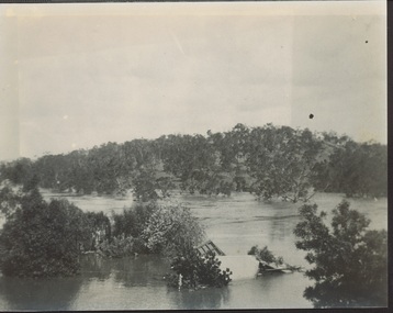
... Extreme flood events of the Yarra River are recorded to have occurred in 1891, 1901, 1916, 1923 and 1934. ...Extreme flood events of the Yarra River are recorded to have occurred in 1891, 1901, 1916, 1923 and 1934. ...Flooding of the Yarra Valley, including that section of the Yarra bordering Kew and Kew East in the north and west of the municipality, was a regular occurrence. Extreme flood events of the Yarra River are recorded to have occurred in 1891, 1901, 1916, 1923 and 1934. The Municipality of Kew's response to these floods was to enact planning decisions restricting residential development in flood prone areas following the floods of 1916, 1921 and 1934. While floods continued after the development of the Upper Yarra Reservoir (construction 1948-57), the regularity and extent of these inundations diminished.Black and white print positive. Yarra River at Fairfield in 1934. Major flood resulting in submerged buildings in middle ground and onlookers on far bankReverse: "Flood of Yarra at Fairfield Park 1934"fairfield park, yarra valley, river yarra, floods -- 1934 -
 Kew Historical Society Inc
Photograph - Yarra in Flood, 1934
... Extreme flood events of the Yarra River are recorded to have occurred in 1891, 1901, 1916, 1923 and 1934. ...Extreme flood events of the Yarra River are recorded to have occurred in 1891, 1901, 1916, 1923 and 1934. ...Flooding of the Yarra Valley, including that section of the Yarra bordering Kew and Kew East in the north and west of the municipality, was a regular occurrence. Extreme flood events of the Yarra River are recorded to have occurred in 1891, 1901, 1916, 1923 and 1934. The Municipality of Kew's response to these floods was to enact planning decisions restricting residential development in flood prone areas following the floods of 1916, 1921 and 1934. While floods continued after the development of the Upper Yarra Reservoir (construction 1948-57), the regularity and extent of these inundations diminished.Black and white print positive. 1934 floods of the Yarra Valley. Location Fairfield looking towards wooded hillside. Houses floating in river.Reverse: "From Fairfield Park (11936?) back towards hill (Wurundjeri Spur?)"floods -- 1934, yarra valley, yarra river, fairfield park -
 Kew Historical Society Inc
Photograph - River Yarra in Flood from Kilby Road
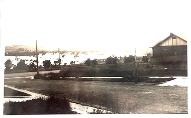
... Extreme flood events of the Yarra River are recorded to have occurred in 1891, 1901, 1916, 1923 and 1934. ...Extreme flood events of the Yarra River are recorded to have occurred in 1891, 1901, 1916, 1923 and 1934. ...Flooding of the Yarra Valley, including that section of the Yarra bordering Kew and Kew East in the north and west of the municipality, was a regular occurrence. Extreme flood events of the Yarra River are recorded to have occurred in 1891, 1901, 1916, 1923 and 1934. The Municipality of Kew's response to these floods was to enact planning decisions restricting residential development in flood prone areas following the floods of 1916, 1921 and 1934. While floods continued after the development of the Upper Yarra Reservoir (construction 1948-57), the regularity and extent of these inundations diminished.Print copy of an original photo of the River Yarra in Flood, taken from Kilby Road.VIEW ACROSS YARRA IN FLOOD / FROM KILBY RD KEWkilby road, floods -- kew (vic.), kilby farm -
Kew Historical Society Inc
Collection, Floods in North Kew (Series), 1929–1934
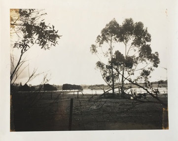
... Extreme flood events of the Yarra River are recorded to have occurred in 1891, 1901, 1916, 1923 and 1934. ...Extreme flood events of the Yarra River are recorded to have occurred in 1891, 1901, 1916, 1923 and 1934. ...Flooding of the Yarra Valley, including that section of the Yarra bordering Kew and Kew East in the north and west of the municipality, was a regular occurrence. Extreme flood events of the Yarra River are recorded to have occurred in 1891, 1901, 1916, 1923 and 1934. The Municipality of Kew's response to these floods was to enact planning decisions restricting residential development in flood prone areas following the floods of 1916, 1921 and 1934. While floods continued after the development of the Upper Yarra Reservoir (construction 1948-57), the regularity and extent of these inundations diminished. Natural disasters had an impact on the development and settlement of Melbourne and its suburbs. Flooding in the Melbourne region was a regular event in the nineteenth and for most of the twentieth centuries. Changes in the impact of natural disasters could occur due to a number of factors. This collection of small snapshots, mostly taken from Kellett Grove in North Kew, provide provenanced evidence of flooding in the area before the development of the unnatural flood barrier that is the Eastern Freeway.Collection of 16 monochrome photographs, annotated on verso by different hands, of the flooding of the River Yarra in North Kew in the third and fourth decades of the twentieth century [1920s & 1930s]. Individual photos include the dates of different floods. Many of the photos were taken from the rear of 8 Kellett Grove; a house still extant in 2023yarra river -- north kew, floods -- yarra valley, floods -- north kew, floods -- 1929, floods -- 1934, natural disasters -- kew -
 Kew Historical Society Inc
Photograph - Yarra Valley Floods: Kew East, 1916
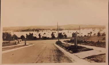
... Extreme flood events of the Yarra River are recorded to have occurred in 1891, 1901, 1916, 1923 and 1934. ...Extreme flood events of the Yarra River are recorded to have occurred in 1891, 1901, 1916, 1923 and 1934. ...Flooding of the Yarra Valley, including that section of the Yarra bordering Kew and Kew East in the north and west of the municipality, was a regular occurrence. Extreme flood events of the Yarra River are recorded to have occurred in 1891, 1901, 1916, 1923 and 1934. The Municipality of Kew's response to these floods was to enact planning decisions restricting residential development in flood prone areas following the floods of 1916, 1921 and 1934. While floods continued after the development of the Upper Yarra Reservoir (construction 1948-57), the regularity and extent of these inundations diminished. During the nineteenth century, the land abutting the south side of the Yarra in Kew was devoted to dairy farming. In the twentieth century, before and after the construction of the Eastern Freeway, much of this low-lying area was used as golf courses and public parks.One of a collection of photographs of flooding in the Kew section of the Yarra Valley which are in important research resource for the location and extent of flooding in the first half of the twentieth century. Flooding of the Yarra Valley at East Kew in 1916. The view is taken from the intersection of Kilby Road with what is believed to be Birdwood Street, looking across the flood waters to Ivanhoe. The extensive flooded area shown in the photograph would have included the Kew Golf Club. Verso: "Floods along Kilby Road / near Birdwood St? & Kilby Road / 1917? / 87yarra river, yarra valley, floods -- kew, kilby road -- kew (vic.), kew golf club -
 Kew Historical Society Inc
Photograph - Yarra Valley Floods: Kew East, 1916
... Extreme flood events of the Yarra River are recorded to have occurred in 1891, 1901, 1916, 1923 and 1934. ...Extreme flood events of the Yarra River are recorded to have occurred in 1891, 1901, 1916, 1923 and 1934. ...Flooding of the Yarra Valley, including that section of the Yarra bordering Kew and Kew East in the north and west of the municipality, was a regular occurrence. Extreme flood events of the Yarra River are recorded to have occurred in 1891, 1901, 1916, 1923 and 1934. The Municipality of Kew's response to these floods was to enact planning decisions restricting residential development in flood prone areas following the floods of 1916, 1921 and 1934. While floods continued after the development of the Upper Yarra Reservoir (construction 1948-57), the regularity and extent of these inundations diminished. During the nineteenth century, the land abutting the south side of the Yarra in Kew was devoted to dairy farming. In the twentieth century, before and after the construction of the Eastern Freeway, much of this low-lying area was used as golf courses and public parks.One of a collection of photographs of flooding in the Kew section of the Yarra Valley which are in important research resource for the location and extent of flooding in the first half of the twentieth century. Flooding of the Yarra Valley at East Kew in 1916. The view is taken from a street (maybe Birdwood Avenue) intersecting with Kilby Road looking northeast across the flood waters to Ivanhoe and Heidelberg. The extensive flooded area shown in the photograph would have included remnant dairy farms and the Kew Golf Club. Verso: "Floods / Yarra River / East Kew / Kilby Road / 1917? / 87"yarra river, yarra valley, floods -- kew, kilby road -- kew (vic.), kew golf club -
 Kew Historical Society Inc
Photograph - Flooding of the Yarra Valley at Kew East, 1974
... Extreme flood events of the Yarra River are recorded to have occurred in 1891, 1901, 1916, 1923 and 1934. ...Extreme flood events of the Yarra River are recorded to have occurred in 1891, 1901, 1916, 1923 and 1934. ...Flooding of the Yarra Valley, including that section of the Yarra bordering Kew and Kew East in the north and west of the municipality, was a regular occurrence. Extreme flood events of the Yarra River are recorded to have occurred in 1891, 1901, 1916, 1923 and 1934. The Municipality of Kew's response to these floods was to enact planning decisions restricting residential development in flood prone areas following the floods of 1916, 1921 and 1934. While floods continued after the development of the Upper Yarra Reservoir (construction 1948-57), the regularity and extent of these inundations diminished. During the nineteenth century, the land abutting the south side of the Yarra in Kew was devoted to dairy farming. In the twentieth century, before and after the construction of the Eastern Freeway, much of this low-lying area was used as golf courses and public parks.Late example of the capacity of the Yarra Valley at Kew to flood, even though drainage works and the Upper Yarra Reservoir had reduced their regularity.Original black and white print photograph of the low-lying land at East Kew under floodwater on 16 May 1974. The vantage point of the photographer is Lister Street. In the photo, the fences of the Kilby Farm can be seen. Flooding was caused by overflowing water in Glass' Creek and the River Yarra. Annotation verso: "Hay's Paddock op No.30 Lister Street / 16 May 1974 11.50am / R.L. 46.04"hays paddock, floods, yarra river, glass' creek, lister street