Showing 37 items matching "flumes"
-
 Stawell Historical Society Inc
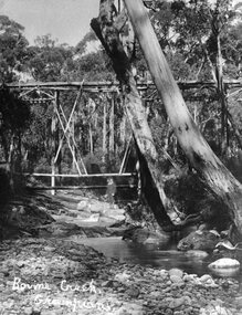
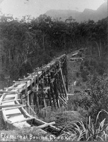
Photograph, Stawell Water Supply Fluming over the Bovine Creek. Same as 0360
... Stawell Water Supply Fluming Bovine Creek...Fluming at Bovine Creek....Stawell Historical Society Inc 46 Longfield St Stawell grampians Stawell Water Supply Fluming Bovine Creek Stawell Flume Fluming at Bovine Creek. ...Stawell Water Supply Fluming Bovine CreekBlack and white photo of timber structure in timbered location with mountains in background.Fluming at Bovine Creek.stawell flume -
 Stawell Historical Society Inc
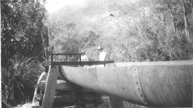
Photograph, Metal Water Fluming in the Grampians -- 7 Photos
... Seven photos showing different views of Metal Water Fluming in the Grampians....Seven black and white photo of Fluming Water Supply Grampians...Stawell Historical Society Inc 46 Longfield St Stawell grampians Seven photos showing different views of Metal Water Fluming in the Grampians. grampians water supply flume Seven black and white photo of Fluming Water Supply Grampians Metal Water Fluming in the Grampians -- 7 Photos Photograph ...Seven photos showing different views of Metal Water Fluming in the Grampians.Seven black and white photo of Fluming Water Supply Grampiansgrampians water supply flume -
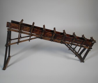 Bendigo Historical Society Inc.
Functional object - MODEL OF FLUME SECTION
... Wooden model of flume section. Painted brown....History House 11 Mackenzie Street Bendigo goldfields BENDIGO Gold mining Wooden model of flume section. Painted brown. Functional object MODEL OF FLUME SECTION ...Wooden model of flume section. Painted brown.bendigo, gold mining -
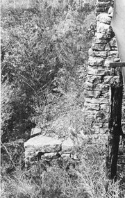
 Stawell Historical Society Inc
Photograph, Stawell water stone Flue in Grampians 1920's
... View in Grampians of stone piers of Stawell water supply flume. ...Stawell water supply Flue 1920's View in Grampians of stone piers of Stawell water supply flume. Stawell water stone Flue in Grampians 1920's Photograph ...From Cragg family. View in Grampians of stone piers of Stawell water supply flume. Stawell water supply Flue 1920's -
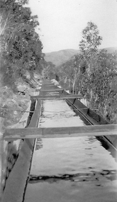 Stawell Historical Society Inc
Photograph, Water Flume fo the Stawell Water Supply
... Water Flume fo the Stawell Water Supply...B/W Photograph of Water Flume with trees either side. Mountain Range in Background. ...This was part of Stawell Water Supply. Water Flume fo the Stawell Water Supply Photograph ...B/W Photograph of Water Flume with trees either side. Mountain Range in Background. This was part of Stawell Water Supply. water supply, water -
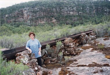 Stawell Historical Society Inc
Photograph, Fluming Water Supply in the Grampians with Stawell Historical Society Members inspecting the old Fluming -- 6 photos -- Coloured
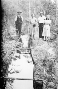
... Six coloured photos of Stawell Historical Society Members inspecting the old fluming. Some of the photos are of the remains of the open water flume in Grampians. ...Fluming Water Supply in the Grampians with Stawell Historical Society Members inspecting the old Fluming -- 6 photos -- Coloured Photograph ...Six coloured photos of Stawell Historical Society Members inspecting the old fluming. Some of the photos are of the remains of the open water flume in Grampians. 6 coloured photos of various views of water pipe line through different locations.grampians water supply flume -
 Bendigo Historical Society Inc.
Photograph - JOSEPH BRADY COLLECTION: BYRNE'S TUNNEL, COLIBAN SYSTEM
... Constructed 1927/28. Concrete ground fluming....Constructed 1927/28. Concrete ground fluming. Photograph JOSEPH BRADY COLLECTION: BYRNE'S TUNNEL, COLIBAN SYSTEM ...Photograph black and white. Comments on back of photo: 1st Gully upstream of Byrne's Tunnel. Constructed 1927/28. Concrete ground fluming.place, water, coliban race, john brady collection. coliban race -
 Stawell Historical Society Inc
Photograph, Stawell Water Supply Fluming in the Grampians
... Stawell Water Supply Fluming in Grampians...Stawell Historical Society Inc 46 Longfield St Stawell grampians Stawell Water Supply Fluming in Grampians Stawell Flume Stawell Water Supply Fluming in the Grampians Photograph ...Stawell Water Supply Fluming in Grampiansstawell flume -
 Stawell Historical Society Inc
Photograph, Stawell Water Supply Fluming over the Bovine Creek
... Stawell Water Supply Bovine Creek. Fluming....Stawell Historical Society Inc 46 Longfield St Stawell grampians Stawell Water Supply Bovine Creek. Fluming. Stawell Flume Stawell Water Supply Fluming over the Bovine Creek Photograph ...Stawell Water Supply Bovine Creek. Fluming.stawell flume -
 Stawell Historical Society Inc
Photograph, Stawell Water Supply's Open Fluming c1948
... Open Fluming Stawell Water Supply c1948...Stawell Historical Society Inc 46 Longfield St Stawell grampians Open Fluming Stawell Water Supply c1948 Stawell Stawell Water Supply's Open Fluming c1948 Photograph ...Open Fluming Stawell Water Supply c1948stawell -
 Stawell Historical Society Inc
Photograph, Stawell Water Supply fluming at Bovine Creek in the Grampians. Same as 1443
... Grampians - Stawell Water Supply fluming at Bovine Creek...Stawell Water Supply fluming at Bovine Creek in the Grampians. Same as 1443 Photograph ...Grampians - Stawell Water Supply fluming at Bovine CreekBlack and white photo of a timber structure built in timbered area with mountains in the background. -
 Eltham District Historical Society Inc
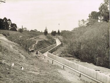
Album - Photograph, J.A. McDonald, Yarra Glen-Glenburn Road, Nov. 1956
... Cylinder foundation – Jehosophat Creek Showing flume – March 1956...Eltham District Historical Society Inc 728 Main Rd Eltham melbourne Cylinder foundation – Jehosophat Creek Showing flume – March 1956 Record of various Shire of Eltham infrastructure works undertaken during the period of 1952-1962 involving bridge and road reconstruction projects, sometimes with Eltham Shire Council Project Reference numbers quoted. ...Cylinder foundation – Jehosophat Creek Showing flume – March 1956Record of various Shire of Eltham infrastructure works undertaken during the period of 1952-1962 involving bridge and road reconstruction projects, sometimes with Eltham Shire Council Project Reference numbers quoted. It was during this period that a number of significant improvements were made to roads and new bridges constructed within the shire that remain in place as of present day (2022). In many situations, the photos provide a tangible visible record of infrastructure that existed throughout the early days of the Shire. The album was put together by or under the direction of the Shire Engineer, J.A. McDonald.infrastructure, shire of eltham, 1956-03, bridge construction, jehosophat creek, road construction, yarra glen-glenburn road -
 Stawell Historical Society Inc
Photograph, Fluming Water Supply in the Grampians 1991 -- 9 Photos -- Coloured
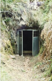
... Halls Gap Old pipe to open flume adapter Nov 24/1991. e. Halls Gap Old metal open flume Nov24/91. f. ...Halls Gap Old pipe to open flume adapter Nov 24/1991. e. Halls Gap Old metal open flume Nov24/91. f. ...Coloured photos of Fluming Water Supply in the Grampians. a. Grampians Exit of tunnel through Mt William Range built 1874. b. Halls Gap Fyan's Creek with buried pipe from new diversion Weir Nov 24/91 (Fume Main). c. Halls Gap New Diversion Weir (Keith Phillips) Nov 24/1991. d. Halls Gap Old pipe to open flume adapter Nov 24/1991. e. Halls Gap Old metal open flume Nov24/91. f. Halls Gap Old metal flume and man made stone supporting wall. g. Halls Gap Overhanging rocks above old fume line Nov 24/1991. h. Halls Gap Old pipe to open flume adapter Bill Holmes Nov 24/91. i. Grampians Old hut for controlling flow valves etc. at Stawell side of Mount William Range after tunnel exit. Nine colour photographs of various views around a tunnel through a hill site.grampians water supply flume -
 Federation University Historical Collection
Photograph - Black and White photograph, N. Harvey and Son, Ballarat School of Mines Laboratory Activities, 11/02/1972
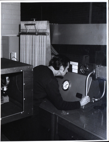
... Three males at a glass-sides tilting flume apparatus....Three males at a glass-sides tilting flume apparatus. Ballarat School of Mines Laboratory Activities Photograph Black and White photograph N. ...Photograph of laboratories at the Ballarat School of Mines. 1. A male person at the viewing window of a wind tunnel. The man is probably Zig Plavina 2. Three males at a glass-sides tilting flume apparatus.ballarat school of mines, laboratory, tilting flume, wind tunnel, zig plavina -
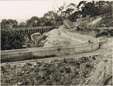
 Bendigo Historical Society Inc.
Photograph - JOSEPH BRADY COLLECTION: COLIBAN RACE CONCRETE FLUMING
... Comments received with photo: Coliban Race Concrete grand fluming at 12.5 miles main channel; 8 feet wide, 4 foot 6 inches high constructed 1928....Photograph JOSEPH BRADY COLLECTION: COLIBAN RACE CONCRETE FLUMING ...Photograph - black and white. Comments received with photo: Coliban Race Concrete grand fluming at 12.5 miles main channel; 8 feet wide, 4 foot 6 inches high constructed 1928.place, water, coliban race, john brady collection. coliban race -
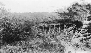
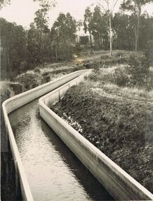
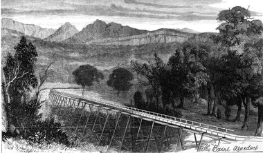 Stawell Historical Society Inc
Drawing, Stawell Water Supply Bovine Aqueduct 1881 -- Sketch
... D'Alton's suggestion was that the water be carried from the source in an open channel two miles, then in a flume of timber. Later surveyed and planned a tunnel on a good line - to reduce the flume 72 miles and the main to Stawell to 15 miles. ...D'Alton's suggestion was that the water be carried from the source in an open channel two miles, then in a flume of timber. Later surveyed and planned a tunnel on a good line - to reduce the flume 72 miles and the main to Stawell to 15 miles. ...Sketches of Stawell Water Supply Bovine Aqueduct October 5th 1881. The Grampian scheme planned by the the Borough Engineer John D'Alton. D'Alton's suggestion was that the water be carried from the source in an open channel two miles, then in a flume of timber. Later surveyed and planned a tunnel on a good line - to reduce the flume 72 miles and the main to Stawell to 15 miles. This sketch (illustrated Australian News October 5, 1881).Black and white photograph of a sketch a bush scene with mountains in background. The sketch depicts a trestle bridge construction. The Bovine Aqueduct stawell water supply -
 Bendigo Historical Society Inc.
Slide - DIGGERS & MINING. DIGGERS AND MINERS, 1800s
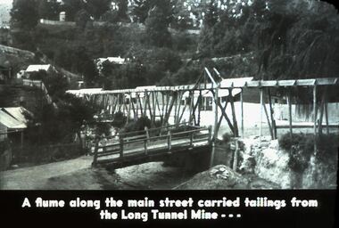
... Diggers and Miners. A flume along the main street carried tailings from the Long Tunnel Mine. ...Diggers and Miners. A flume along the main street carried tailings from the Long Tunnel Mine. ...Diggers & Mining. Diggers and Miners. A flume along the main street carried tailings from the Long Tunnel Mine. Picture shows this. Markings: 42 994.5 WAL. Used as a teaching aid. Used as a teaching aid.hanimounteducation, tertiary, goldfields -
 Bendigo Historical Society Inc.
Slide - DIGGERS & MINING. DIGGERS AND MINERS, 1800s
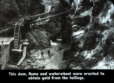
... Diggers and Miners. This dam, flume and waterwheel were erected to obtain gold from the tailings. ...Diggers and Miners. This dam, flume and waterwheel were erected to obtain gold from the tailings. ...Diggers & Mining. Diggers and Miners. This dam, flume and waterwheel were erected to obtain gold from the tailings. Picture shows the section of the dam, wheel and waterway. Markings: 41 994.5 WAL. Used as a teaching aid. Used as a teaching aid.hanimounteducation, tertiary, goldfields -
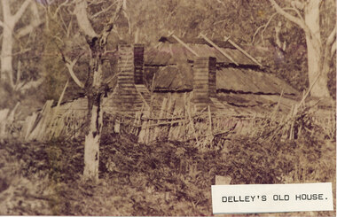 Halls Gap & Grampians Historical Society
Photograph - Sepia, C 1876
... The roof is constructed of wooden slats held down by pieces of what appears to be fluming. There are two chimneys and the lower half of the house is obscured by a stick fence and undergrowth. ...The roof is constructed of wooden slats held down by pieces of what appears to be fluming. There are two chimneys and the lower half of the house is obscured by a stick fence and undergrowth. ...This is a photo of Delley's house. For further information see "Bridging The Gap" p13-14,17,22,54. This photo is an enlargement of a portion of Record 531.Photo shows old house. The roof is constructed of wooden slats held down by pieces of what appears to be fluming. There are two chimneys and the lower half of the house is obscured by a stick fence and undergrowth. There is a large tree in the foreground and another in the far right background. The house is surrounded by bush.buildings, houses -
 Bendigo Historical Society Inc.
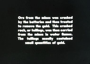
Slide - DIGGERS & MINING. DIGGERS AND MINERS, 1800s
... This crushed rock, or tailings, was then carried from the mines in water flumes. The tailings usually contained small quantities of gold. ...This crushed rock, or tailings, was then carried from the mines in water flumes. The tailings usually contained small quantities of gold. ...Diggers & Mining. Diggers and Miners. Ore from the mines was crushed by the batteries and them treated to remove the gold. This crushed rock, or tailings, was then carried from the mines in water flumes. The tailings usually contained small quantities of gold. Markings: 40 994.5 WAL. Used as a teaching aid. Used as a teaching aid.hanimounteducation, tertiary, goldfields -
 Federation University Historical Collection
Book, Hydraulic and Placer Mining, 1898, 1905
... Contents include Uses of Water in Mining; Geology of Placer Deposits; Gold Recovery; Flumes, ditches, dams, pipes; Giants, valaves, gates, weirs, miner's inch, pressure box, dams; gravel elvators; exploiting. ...Contents include Uses of Water in Mining; Geology of Placer Deposits; Gold Recovery; Flumes, ditches, dams, pipes; Giants, valaves, gates, weirs, miner's inch, pressure box, dams; gravel elvators; exploiting. ...Blue/black hard covered book of 234 pages including index and photographic reproductions. Contents include Uses of Water in Mining; Geology of Placer Deposits; Gold Recovery; Flumes, ditches, dams, pipes; Giants, valaves, gates, weirs, miner's inch, pressure box, dams; gravel elvators; exploiting. mining, hydraulics, water, dredge, dredging, gold mining -
 Bendigo Historical Society Inc.
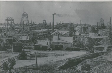
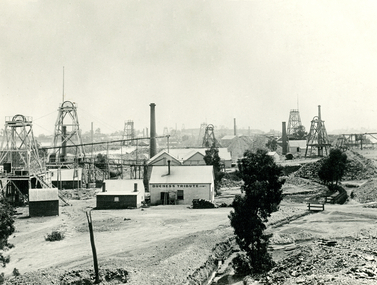
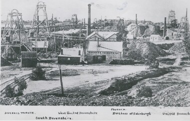
Photograph - DEVONSHIRE GROUP OF MINES
... At least 11 chimneys and many buildings associated with the mines. Centre to left, flume, wood stacks, mullock heaps. In image ' Duchess Tribute' on weatherboard building at centre. ...At least 11 chimneys and many buildings associated with the mines. Centre to left, flume, wood stacks, mullock heaps. In image ' Duchess Tribute' on weatherboard building at centre. ...black and white photograph, view across mining area showing at least 9 poppet heads. At least 11 chimneys and many buildings associated with the mines. Centre to left, flume, wood stacks, mullock heaps. In image ' Duchess Tribute' on weatherboard building at centre. On back '12' Devonshire gorup' in ball point pen. MNG 1.buildings, commercial, devonshire group of mines -
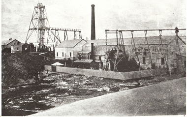 Bendigo Historical Society Inc.
Photograph - CATHERINE REEF UNITED CLAIMHOLDERS MINE, 1870's ?
... Black and white photo: poppet head, chimney, corrugated iron and weatherboard buildings, flumes. On building 'Catherine Reef/Unit..g.. ( partly obscured ) 'Catherine Reef United Claimholders' written on back in ball point pen...History House 11 Mackenzie Street Bendigo goldfields MINE Gold catherine reef mine Bendigo mines and mining mines poppet head gold mining mining Black and white photo: poppet head, chimney, corrugated iron and weatherboard buildings, flumes. On building 'Catherine Reef/Unit..g.. ( partly obscured ) 'Catherine Reef United Claimholders' written on back in ball point pen. '15' A. ...Black and white photo: poppet head, chimney, corrugated iron and weatherboard buildings, flumes. On building 'Catherine Reef/Unit..g.. ( partly obscured ) 'Catherine Reef United Claimholders' written on back in ball point pen. '15' A. Richardson, 29 Harrison St., Bendigo. On front top left corner in margin written in ball point pen '15'mine, gold, catherine reef mine, bendigo, mines and mining, mines, poppet head, gold mining, mining -
 Bendigo Historical Society Inc.
Photograph - DEVONSHIRE GROUP OF MINES,1896
... View across mining area showing at least 9 poppet heads, 11 chimneys and many buildings associated with the mines. C to L - flume, wood stacks, mullock heaps. Inscription in image 'Duchess Tribute' on weatherboard building at C. ...View across mining area showing at least 9 poppet heads, 11 chimneys and many buildings associated with the mines. C to L - flume, wood stacks, mullock heaps. Inscription in image 'Duchess Tribute' on weatherboard building at C. ...Black and white photograph. View across mining area showing at least 9 poppet heads, 11 chimneys and many buildings associated with the mines. C to L - flume, wood stacks, mullock heaps. Inscription in image 'Duchess Tribute' on weatherboard building at C. On back, blue circular stamp 'Historical Society of Victoria, Bendigo Branch', 'MP 264'.James Lerk 26/11/1999place, mining site, see also 2000.426.01, 2000.437.01, 2000.438.01, 2000.439.01, 2000.504.01, 2000.507.01, 2000.508.01 -
 Warrnambool and District Historical Society Inc.
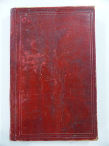
Book, John Ross notebook, 1890s
... The jobs include ‘Russells Creek from the Merri River upwards’, ‘Outlet at the Flume’, ‘Guns at the Battery’ and Drainage from the Terminus Hotel to the end of the Japan Street Tunnel’. ...The jobs include ‘Russells Creek from the Merri River upwards’, ‘Outlet at the Flume’, ‘Guns at the Battery’ and Drainage from the Terminus Hotel to the end of the Japan Street Tunnel’. ...This small note book belonged to John Ross, the Warrnambool Town Surveyor and Engineer (1889-1906 & 1913-1914). The book lists the levels taken for the benefit of contractors undertaking jobs for the Warrnambool Council from 1898 to 1902. The jobs include ‘Russells Creek from the Merri River upwards’, ‘Outlet at the Flume’, ‘Guns at the Battery’ and Drainage from the Terminus Hotel to the end of the Japan Street Tunnel’. John Ross was also in private practice with the architectural firm of Ross and Jackman. This notebook is of considerable interest because it is an original note book that belonged to John Ross, the Warrnambool Town Surveyor and Engineer in the late 19th century and early 20th century. The note book contains important information on the engineering projects in Warrnambool and district from 1898 to 1902. This note book has a red leather cover. The cover is a little creased. The inside pages have ruled red lines and printed headings regarding the levels taken of a site and the location of the site (1898 to 1902). The engineer’s entries in the printed columns are handwritten , mostly in pencil. The inscription on the first page is handwritten in black ink. ‘Jno C Ross, Town Surveyor Wbool 19/5/98’ john ross, warrnambool town council, history of warrnambool -
 Bendigo Historical Society Inc.
Photograph - JOSEPH BRADY COLLECTION: FLUMING BETWEEN MALMSBURY RESERVOIR AND CALDER HIGHWAY, 1934
... JA 10/81 concrete grand fluming at 12.5 miles Main channel 8 feet wide 4 foot 6 inches high. ...Photograph JOSEPH BRADY COLLECTION: FLUMING BETWEEN MALMSBURY RESERVOIR AND CALDER HIGHWAY ...Black and white photograph: image shows concrete channel snaking down hill, top LH side appears to be bluestone mill with tall chimney. Trees on RH side of channel. Comments on the back of the photo 'Between Malmsbury Res and Calder Hwy. 8 feet wide 4 foot 6 inches deep. Taken 1934. JA 10/81 concrete grand fluming at 12.5 miles Main channel 8 feet wide 4 foot 6 inches high. Constructed 1928.'place, water, coliban race, john brady collection. coliban race -
 Bendigo Historical Society Inc.
Photograph - DEVONSHIRE GROUP OF MINES, C 1896
... black and white photograph 3 copies : view across mining area showing at least 9 poppet heads, at least 11 chimneys and many buildings associated with the mines. Centre to left - flume, wood stacks, mullock heaps. In image ' Duchess Tribute' on weatherboard building at centre. ...History House 11 Mackenzie Street Bendigo goldfields ORGANIZATION Business devonshire group of mines black and white photograph 3 copies : view across mining area showing at least 9 poppet heads, at least 11 chimneys and many buildings associated with the mines. Centre to left - flume, wood stacks, mullock heaps. In image ' Duchess Tribute' on weatherboard building at centre. ...black and white photograph 3 copies : view across mining area showing at least 9 poppet heads, at least 11 chimneys and many buildings associated with the mines. Centre to left - flume, wood stacks, mullock heaps. In image ' Duchess Tribute' on weatherboard building at centre. Handprinted above image ( on earlier copy of this image of which this is a photograph ) ' Devonshire Group of Mines/Snob's Hill and Mungo Mines in Background. Printed below image ' Ducches Tribute' ' South Devonshire' ' West United Devonshire ' ' Phoenix' ' Duchess of Edinburgh' ' United Devonshire 'organization, business, devonshire group of mines -
 Bendigo Historical Society Inc.
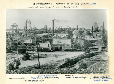
Photograph - SNOBS HILL AND MUNGO MINE IN BACKGROUND, 1876
... View across mining area showing at least 9 poppet heads, 11 chimneys and many bujildings associated with the mines. C-L flume, wood stacks, mullock heaps. Text on photograph: MNG 69 on TL corner. ...View across mining area showing at least 9 poppet heads, 11 chimneys and many bujildings associated with the mines. C-L flume, wood stacks, mullock heaps. Text on photograph: MNG 69 on TL corner. ...Black and white photograph on cream board. View across mining area showing at least 9 poppet heads, 11 chimneys and many bujildings associated with the mines. C-L flume, wood stacks, mullock heaps. Text on photograph: MNG 69 on TL corner. Devonshire Group of Mines - Approximately 1876. Snob's Hill and Mungo Mines in background, Duchess Tribute, United Devonshire, from 1902 (West United Devonshire), South Devonshire, Pheonix, Duchess of Edinburgh. From 1902 called United Devonshire (Princess Alexandra) prior to this. In image 'Duchess Tribute'. On weatherboard building at C.place, mining site, see also 2000 - 426.1, 2000 - 437.01, 2000 - 438.01, 2000 - 439.01, 2000 - 507.01, 2000 - 508.01, 2000 - 509.01 -
 Stawell Historical Society Inc
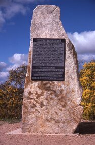
Slide, Ian McCann, Monuments Cnetenaryy of Water Supply
... And involved the costruction of Timber Fluming Mountain Tunnel 300 mm Pipeline 100 years later the principle of the scheme remains the same. ...And involved the costruction of Timber Fluming Mountain Tunnel 300 mm Pipeline 100 years later the principle of the scheme remains the same. ...Momument to commemorate the Centenary of the Stawell Water Supply as designed by Mr. John D'AltonTown of Stawell Erreceted to Commemorate the the Centenary of Stawell's Water Supply System. As Designed by John D'Alton, his sceme included the diversion of Water from Fyan's Creek in the Grampians to Stawell a distance of 35 km. And involved the costruction of Timber Fluming Mountain Tunnel 300 mm Pipeline 100 years later the principle of the scheme remains the same. Work Commenced Feburary 1875 and was completed December 1881. Unveiled by The Hon. F.J. Cranter M.L.C. Minister for Water Supply On Novemebr 15th 1975 Cr. M.K. Hallam J.P. Mayordoctor's hill, hospital -
 Stawell Historical Society Inc
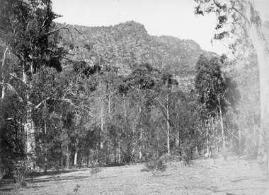
Photograph, Grampians at Halls Gap 1866
... The scheme came from Fyan’s Creek via Wooden Fluming and a Syphon and finally through the mountain in a tunnel, before being piped to a reservoir on Big Hill. ...The scheme came from Fyan’s Creek via Wooden Fluming and a Syphon and finally through the mountain in a tunnel, before being piped to a reservoir on Big Hill. ...Grampians Halls Gap. Part of a collection of Photographs by Mr. O.G. Armstrong as commissioned by the Shire of Stawell for the Inter-colonial and Paris Exhibition in Melbourne in 1866. From about 1860 there was agitation for a water supply, not only for Stawell but for the Wimmer Mallee as well. In 1887 Wartook was adopted as the first reservoir for the Wimmer. Stawells water supply was designed by Mr. John D’Alton. The scheme came from Fyan’s Creek via Wooden Fluming and a Syphon and finally through the mountain in a tunnel, before being piped to a reservoir on Big Hill. The system was completed in December 1881 and although there have been modifications, basically it has not been changed to this day. The Wimmera Mallee stock and domestic system from the Grampians is the largest system of its kind in the world, the latest edition being like Belfield and piping of Wimmera channels. stawell