Showing 89 items matching "fording the river"
-
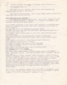
 Camberwell RSL Sub-Branch
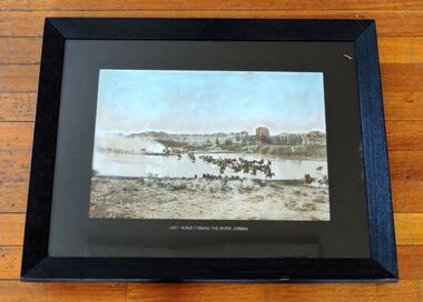
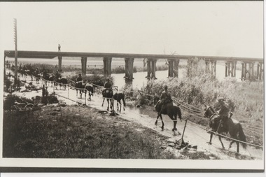
Photo, Australian Light Horse fording the Jordan River March 1918, 1918
... Australian Light Horse fording the Jordan River March 1918...Australian Light Horse fording the Jordan River March 1918...Camberwell RSL Sub-Branch 403 Camberwell Road Camberwell melbourne Unique photo of the Australian Light Horse in the field in Palestine Unique actual photo Australian Light Horse fording the Jordan River March 1918 Photo in Wooden Frame Australian Light Horse fording the Jordan River March 1918 Photo ...Unique photo of the Australian Light Horse in the field in PalestineUnique actual photoPhoto in Wooden FrameAustralian Light Horse fording the Jordan River March 1918 -
 4th/19th Prince of Wales's Light Horse Regiment Unit History Room
Framed Picture, Light Horse, c 1917
... Printed framed photo of Light Horse fording Jordan River during World War 1...Colarts Sydney Caption: Light Horse fording Jordan River...4th/19th Prince of Wales's Light Horse Regiment Unit History Room 4/19 PWLH Regiment, Building 78 Simpson Barracks Macleod melbourne Colarts Sydney Caption: Light Horse fording Jordan River Printed framed photo of Light Horse fording Jordan River during World War 1 Light Horse Framed Picture ...Printed framed photo of Light Horse fording Jordan River during World War 1Colarts Sydney Caption: Light Horse fording Jordan River -
 Orbost & District Historical Society
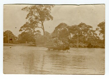
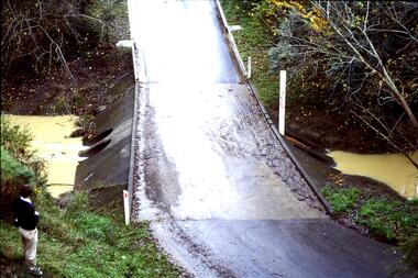
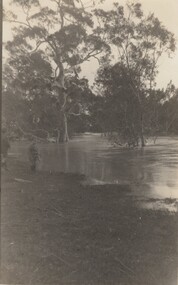
Photograph - crossing the Snowy River, c.1890s-1910
... ...fording the river...Snowy River fording the river On back, written in pencil: 'Snowy Bridge'. ...In the early days of European settlement of the Snowy River area in East Gippsland, from the 1870s onwards, the crossing of the Snowy River often posed difficulties. Presumably, this photograph was taken prior to the first bridge being built at Orbost in 1893.This photo is significant because it shows the difficulties in transport caused by the crossing of the Snowy River. A sepia coloured photograph of two men riding on top of a wagon load of filled bags, the wagon being pulled by two horses. They appear to be crossing a river with water around the wagon and horses. In the background is a river bank, telegraph poles, fence posts, and trees.On back, written in pencil: 'Snowy Bridge'.snowy river, fording the river -
 Marysville & District Historical Society
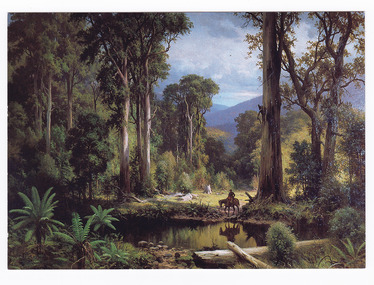
Postcard (item) - Colour postcard, Souvenirs Australia Pty. Ltd, A Ford on the Acheron River, 1881, Post 1995
... A Ford on the Acheron River, 1881...A postcard from a painting of a ford on the Acheron River that was painted in 1881 by H.J. ...A postcard from a painting of a ford on the Acheron River that was painted in 1881 by H.J. ...JOHNSTONE/ A FORD ON THE ACHERON RIVER, 1881/ OIL ON CANVAS, 171cm x 245cm/ BROKEN HILL CITY ART GALLERY/ DONATED BY MR. ...A postcard from a painting of a ford on the Acheron River that was painted in 1881 by H.J. ...A postcard from a painting of a ford on the Acheron River that was painted in 1881 by H.J. Johnstone.A postcard from a painting of a ford on the Acheron River that was painted in 1881 by H.J. Johnstone. The original painting is oil on canvas and was donated to the Broken Hill City Art Gallery in 1948 by Mr. O. Von Rieben. This postcard was produced by Souvenirs Australia Pty. Ltd. in Glynde, South Australia as a souvenir of Marysville.H.J. JOHNSTONE/ A FORD ON THE ACHERON RIVER, 1881/ OIL ON CANVAS, 171cm x 245cm/ BROKEN HILL CITY ART GALLERY/ DONATED BY MR. O. VON RIEBEN, 1948 Made in/ Australia by/ Souvenirs Aust./ Pty. Ltd./ Adelaide/ BHG 2 ADDRESS Published by/ Souvenirs Australia Pty. Ltd./ Glynde/ Copyright A PITT CARDacheron river, oil painting, h.j. johnstone, broken hill city art gallery, mr. o. von rieben, postcard, souvenirs australia, souvenir -
 Sunshine and District Historical Society Incorporated
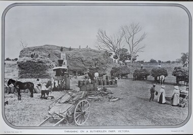
Photograph - Victorian Pioneering Farming / Transport Images
... 1/ Trashing on a Rutherglen Farm Victoria 1911 - Image of various farm machining being used with male and female workers|2/ Coach Road from Omeo to Bright - Image of a four horse drawned carriage with a view of the Victorian Alps in the blackground|3/ Fording the River - Image a bullock drawned carriage fording a river crossing...The pictures were hanging in the Melbourne Swiss Club|Items can been use in a teaching enviroment 1/ Trashing on a Rutherglen Farm Victoria 1911 - Image of various farm machining being used with male and female workers|2/ Coach Road from Omeo to Bright - Image of a four horse drawned carriage with a view of the Victorian Alps in the blackground|3/ Fording the River - Image a bullock drawned carriage fording a river crossing Collection of three black & white images mounted on board Photograph Victorian Pioneering Farming / Transport Images ...The pictures were hanging in the Melbourne Swiss Club|Items can been use in a teaching enviroment1/ Trashing on a Rutherglen Farm Victoria 1911 - Image of various farm machining being used with male and female workers|2/ Coach Road from Omeo to Bright - Image of a four horse drawned carriage with a view of the Victorian Alps in the blackground|3/ Fording the River - Image a bullock drawned carriage fording a river crossing -
 Greensborough Historical Society
Slide - Photograph, John Ramsdale, Ford over Plenty River to Partington's Flat: Slide 72, 1990s
... Ford over Plenty River to Partington's Flat: Slide 72...ford over plenty river...This is the ford over Plenty River to Partington's Flat...This is the ford over Plenty River to Partington's Flat Part of the John Ramsdale collection of slides and audio visual material. ford over plenty river plenty river partington's flat No caption. ...Photograph shows road or path over culvert. This is the ford over Plenty River to Partington's FlatPart of the John Ramsdale collection of slides and audio visual material.Colour photograph scanned from slide.No caption. Printed maker's mark on slide "Kodak Kodachrome Slide"ford over plenty river, plenty river, partington's flat -
 Greensborough Historical Society
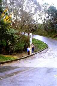
Slide - Photograph, John Ramsdale, Ford over Plenty River at Partington's Flat: Slide 52, 1990s
... Ford over Plenty River at Partington's Flat: Slide 52......ford over plenty river...Photograph shows 2 children with flood height marker at the ford over Plenty River at Partington's Flat...Greensborough Historical Society 34A Glenauburn Road Lower Plenty Lower Plenty melbourne Photograph shows 2 children with flood height marker at the ford over Plenty River at Partington's Flat Part of the John Ramsdale collection of slides and audio visual material. partingtons flat ford over plenty river plenty river No maker's marks. ...Photograph shows 2 children with flood height marker at the ford over Plenty River at Partington's FlatPart of the John Ramsdale collection of slides and audio visual material.Colour photograph scanned from slide.No maker's marks. No caption on slide.partingtons flat, ford over plenty river, plenty river -
4th/19th Prince of Wales's Light Horse Regiment Unit History Room
Display Binder, 2/4 Armoured Regiment Group, abt 2014
... By 1945 the United States publicity machine under General McArthur focussed on US campaigns to the North treating this action as a back water The unit's battle honours comprise South West Pacific 1945, Liberation of Australian New Guinea, Hawain River, Wewak, Wirui Mission, Slater's Knoll, Hongorai River, Egan's Ridge-Hongorai Ford, Hari River and Mivo River...By 1945 the United States publicity machine under General McArthur focussed on US campaigns to the North treating this action as a back water The unit's battle honours comprise South West Pacific 1945, Liberation of Australian New Guinea, Hawain River, Wewak, Wirui Mission, Slater's Knoll, Hongorai River, Egan's Ridge-Hongorai Ford, Hari River and Mivo River 2/4 Armoured Regiment is an antecedent unit of our modern Regiment ., Museum quality 3 ring, A3 size binder with clear inserts for documents and photos, in slip case. ...Provides an excellent account of the service of Australian 2/4 Armoured Regiment Group in New Guinea and Bougainville in World War 2. By 1945 the United States publicity machine under General McArthur focussed on US campaigns to the North treating this action as a back water The unit's battle honours comprise South West Pacific 1945, Liberation of Australian New Guinea, Hawain River, Wewak, Wirui Mission, Slater's Knoll, Hongorai River, Egan's Ridge-Hongorai Ford, Hari River and Mivo River2/4 Armoured Regiment is an antecedent unit of our modern Regiment ., Museum quality 3 ring, A3 size binder with clear inserts for documents and photos, in slip case. Presents history of Australian 2/4 Armoured Group in South West Pacific in World War 2 -
Sunshine and District Historical Society Incorporated
Photograph - Solomons Ford, n.d
... Ford... Maribyrnong River...Photo of Solomons Ford over Maribyrnong River Depicts animals drinking at the ford a person centre left and another near a wagon suggesting the animals may be part of bullock teams Also a house on the horizon...Solomons Ford Maribyrnong River Braybrook Photo of Solomons Ford over Maribyrnong River Depicts animals drinking at the ford a person centre left and another near a wagon suggesting the animals may be part of bullock teams Also a house on the horizon Solomons Ford Photograph Solomons Ford ...Photo of Solomons Ford over Maribyrnong River Depicts animals drinking at the ford a person centre left and another near a wagon suggesting the animals may be part of bullock teams Also a house on the horizonsolomons ford, maribyrnong river, braybrook -
Glenelg Shire Council Cultural Collection
Booklet - Booklet - Nelson and Glenelg River, Victoria, Compiled by N.F. Learmonth, Three Ways to Cross a River, Mar-63
... Booklet - 'Three Ways to Cross a River', a short history of Nelson, focussing on the crossings of the Glenelg River - ford, punt and bridge. Blue card, cover, black print. ...Glenelg Shire Council Cultural Collection History House Cliff Street Portland great-ocean-road Booklet - 'Three Ways to Cross a River', a short history of Nelson, focussing on the crossings of the Glenelg River - ford, punt and bridge. Blue card, cover, black print. ...Booklet - 'Three Ways to Cross a River', a short history of Nelson, focussing on the crossings of the Glenelg River - ford, punt and bridge. Blue card, cover, black print. Complied to mark the occasion of the opening of the new Glenelg River bridge at Nelson, 14 Mar 1963 -
 Federation University Historical Collection
Photograph - Photograph - black and white, Oallen Ford and Shoalhaven River, 1934, 1934
... Oallen Ford and Shoalhaven River, 1934...He is at Oallen Ford on the Shoalhaven River, New South Wales .2) A man stands beside a ute with 2 women standing on the tray. ... on the Shoalhaven River, New South Wales .2) A man stands beside a ute with 2 women standing on the tray. The photo was taken after crossing a ford at Shoalhaven, New South Wales Oallen Ford and Shoalhaven River, 1934 Photograph Photograph - black and white ...Two black and white photographs associated with Donald Mather. .1) A man, Tom Davis stands surrounded with gold mining equipment such as gold pans, cradles, picks and buckets. He is at Oallen Ford on the Shoalhaven River, New South Wales .2) A man stands beside a ute with 2 women standing on the tray. The photo was taken after crossing a ford at Shoalhaven, New South Walesdonald mather, mather, shoalhaven river, mining, ute, utility, car, gold mining -
 Federation University Historical Collection
Postcards - black and white, Butt Bourton, Burford
... Burford is a small town on the River Windrush in the Cotswold hills in west Oxfordshire, England, about 18 miles (29 km) west of Oxford, 22 miles (35 km) southeast of Cheltenham and only about 2 miles (3 km) from the Gloucestershire boundary. The toponym derives from the Old English words burh meaning fortified town or hilltown and ford...Barker Library (top floor) Mount Helen goldfields Burford is a small town on the River Windrush in the Cotswold hills in west Oxfordshire, England, about 18 miles (29 km) west of Oxford, 22 miles (35 km) southeast of Cheltenham and only about 2 miles (3 km) from the Gloucestershire boundary. The toponym derives from the Old English words burh meaning fortified town or hilltown and ford ...Burford is a small town on the River Windrush in the Cotswold hills in west Oxfordshire, England, about 18 miles (29 km) west of Oxford, 22 miles (35 km) southeast of Cheltenham and only about 2 miles (3 km) from the Gloucestershire boundary. The toponym derives from the Old English words burh meaning fortified town or hilltown and ford, the crossing of a river. (Wikipedia)A streetscape photographic view of Burford, England showing buildings, cars and people. chatham family archive, burford -
 Orbost & District Historical Society
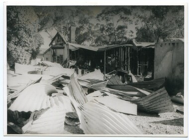
Photograph - Bemm River hotel fire
... There have been several Bemm River hotels since 1891 when the first Hotel was built by Henry Summer. This Hotel was located near a ford where traffic crossed the river. ...There have been several Bemm River hotels since 1891 when the first Hotel was built by Henry Summer. This Hotel was located near a ford where traffic crossed the river. ...Bemm River is a small township in East Gippsland. There have been several Bemm River hotels since 1891 when the first Hotel was built by Henry Summer. This Hotel was located near a ford where traffic crossed the river. Annie Morgan was the next person to have a roadside licence to sell liquor at Bemm River, also known as Sydenham Inlet Hotel. In 1927, a hotel was built on the present site at Bemm River, again with the Morgan family. Like many hotels, the Bemm River hotel has burned down or suffered damage through fires and was rebuilt. These photos are likely of a fire at the Hotel in 1994 which resulted in the hotel burning down. It was re-built in 2000 on the same site.History of Bemm River and its hotel5 b/w photos showing a building with severe fire damage, and two people in front of the photos (probably owners).nonebemm river, fire, hotels -
 Sunshine and District Historical Society Incorporated
Archive - Interview With Mace Myers, Mace Myers, 6th December 1976
... Braybrook State School Braybrook Hotel Pennells Private School Pickett Street Footscray Sunshine Mechanics Hall Braybrook Public Hall Harrison's Hall (Next to the Deer Park Hotel) Maribyrnong River Fords (Mentions two fords across the river) Glengala Estate...Braybrook State School Braybrook Hotel Pennells Private School Pickett Street Footscray Sunshine Mechanics Hall Braybrook Public Hall Harrison's Hall (Next to the Deer Park Hotel) Maribyrnong River Fords (Mentions two fords across the river) Glengala Estate Typed summary of a transcript. ...Gladys Maissie "Mace" Babb (b28/10/1889 d22/1/1982) married George Napier Myers (b29/10/1879 d23/9/1948) in 1912 in Victoria. Mace was the daughter of James Babb, a pioneer of Braybrook who worked as a caretaker and road contractor. This document is a summary of transcript of an interview between Mrs Mace Myers, aged 87 years old, of her memory of early Braybrook, Braybrook Junction and Sunshine in the early 19th century. Many of the early settlers of the Braybrook District are mentioned throughout the transcript.Interview with Mrs Mace Myers of 32 Monash Street, Footscray on 6th December 1976. Named mentioned during the interview. Lynn Myers Mr Collins (Business at back of home) Hilda Greig Newman's Land Tom Derham Newman (Blacksmith) Dempster Alf Barnett Bob Barnett Donald McLeod (Built stonework of the Braybrook School) Mrs. Holcroft (Fruit and Vegetable Shop) Tom Babb (Boot Repairer) George Costello (Stone Breaker for a Road Construction Gang) James Babb (Boss of a Road Construction Gang) Chinaman (Gardener) Darby Rockett Ted Mackie Mrs. Boyd Tom Cannon Tilly Minns (Braybrook Hotel) Miss Wolley Billy Derham Mary Jane Barnett Jack Derham John Flynn Miss. Harvey "Gabo" Jenkins Eugene Flynn Tribe Jackson Gough Mullenger Rolfe Craddock Dickson Middleton Munro (Cows, milk, etc) Freda Roberts Billy Roberts Cranwell (Grocer & butcher shop) Jack Babb Dr. Webb Gooley's Cracket Factory (Apparently later Phoenix Fireworks) Baker Mrs. Coomber Fred Hill Oscar Hill Lizzie Watson Lizzie Scott Lucy McDonough Rose Barnett Msud Barnett Victor Barnett Jimmy Barnett Alf Barnett Mary Barnett Ivy Steens Blanch Stevens Nurse Kerr Dr. Adamson Locations mentioned during the interview. Braybrook State School Braybrook Hotel Pennells Private School Pickett Street Footscray Sunshine Mechanics Hall Braybrook Public Hall Harrison's Hall (Next to the Deer Park Hotel) Maribyrnong River Fords (Mentions two fords across the river) Glengala Estatemace myers, george napier myrers, gladys maissie babb -
 Sunshine and District Historical Society Incorporated
Document - Summary Of Heritage Overlay Schedule Maribyrnong Planning Scheme Places Formerly Within the City Of Sunshine 13th July 2009, Sunshine and District Historical Society Inc, 13th July 2009
... Wimble & Co 13 - 21 Annesley Street Braybrook HO17 3LO Radion Transmission Station 180 Ashley Street Braybrook HO18 Jacks Magazine (Formerly Saltwater River Magazine) 1 Gordon Street Footscray HO45 Former Melbourne Meat Preserving Co Buildings Pipemakers Park (Including Thompson Reserve) Maribyrnong HO 64) Part Of Ordnance Factory Former No 1 Forge (Demolished) HO71 Part Of Ordnance Factory Former Royal Australian Field Artillery Barracks Wests Road Maribyrnong HO72 ETA Factory 254 Ballarat Road Braybrook (Being Demolished) HO83 Inspection Headquarters (Building 72) Ordnance Reserve Maribyrnong HO86 Pilkington ACI 234 Ballarat Road Braybrook HO91 Braybrook Hotel 351 Ballarat Road Braybrook HO92 Bluestone Cistern (Archaeological Site) 8 - 9 Belvedere Close Maribyrnong HO99 Raleigh Castle (Archaeological Site) 14 Belvedere Close Maribyrnong HO100 Raleigh Castle (Archaeological Site) 15/17 & 1 - 18/18 Belvedere Close Maribyrnong HO100 Kurrajong Street Trees (25 Kurrajong Trees) Bloomfield Avenue Maribyrnong HO105 Solomon's Ford (Canning Street Ford) Maribyrnong River Near Burke Street Braybrook HO109 6738 - Summary Of Heritage Overlay Schedule Maribyrnong Planning Scheme Places Formerly Within the City Of Sunshine Page 2.jpg Pepper Trees, Sugar Gums, Kurrajongs and Canary Island Palms Maribyrnong River Plantation off Chifley Drive Maribyrnong HO110 Klipspringer 40 - 54 Cranwell Street Braybrook HO113 Pridham's Peerless Holdings 19 21 Evans Street Braybrook (Deleted from Overlay) HO118 Raleigh Manager's House (Archaeological Site) 1 & 3 Fabian Court Maribyrnong HO119 Raleigh Castle (Archaeological Site) 1 - 8/5 Fabian Court Maribyrnong HO120 Raleigh Manager's House (Archaeological Site) 2 & 4 Grandview Avenue Maribyrnong HO133 Ralph McKay 44 Hampstead Road Maidstone (Demolished) HO134 Pyrotechnic Division OFM 61 - 71 Hampstead Road Maribyrnong (HO135) Maribyrnong Reserve Grandstand off Hortense Street Maribyrnong HO137 Williamson House 182 Mitchell Street Maidstone HO141 Solomon's House (Archaeological Site) Medway Golf Club 57 Omar Street Maidstone Central Drawing Office (Building 71) Ordnance Reserve Maribyrnong (HO151) Pacific Carpets 35 - 65 Paramount Road corner Indwe Street Tottenham Dale Stables and Elm and Pepper Trees Plantation Street and Chifley Drive Maribyrnong HO153) Olex Cales 207 Sunshine Road Tottenham HO162 Whitshire Files 213 Sunshine Road Tottenham HO163 Black Arch Bridge off Sunshine Road Tottenham HO164 Dale House 44 The Esplanade Maribyrnong HO165 Hardiman House and Garden 76 The Esplanade Maribyrnong HO166 Raleigh Mansion (Archaeological Site) City View Reserve 11 City View Drive Maribyrnong...Wimble & Co 13 - 21 Annesley Street Braybrook HO17 3LO Radion Transmission Station 180 Ashley Street Braybrook HO18 Jacks Magazine (Formerly Saltwater River Magazine) 1 Gordon Street Footscray HO45 Former Melbourne Meat Preserving Co Buildings Pipemakers Park (Including Thompson Reserve) Maribyrnong HO 64) Part Of Ordnance Factory Former No 1 Forge (Demolished) HO71 Part Of Ordnance Factory Former Royal Australian Field Artillery Barracks Wests Road Maribyrnong HO72 ETA Factory 254 Ballarat Road Braybrook (Being Demolished) HO83 Inspection Headquarters (Building 72) Ordnance Reserve Maribyrnong HO86 Pilkington ACI 234 Ballarat Road Braybrook HO91 Braybrook Hotel 351 Ballarat Road Braybrook HO92 Bluestone Cistern (Archaeological Site) 8 - 9 Belvedere Close Maribyrnong HO99 Raleigh Castle (Archaeological Site) 14 Belvedere Close Maribyrnong HO100 Raleigh Castle (Archaeological Site) 15/17 & 1 - 18/18 Belvedere Close Maribyrnong HO100 Kurrajong Street Trees (25 Kurrajong Trees) Bloomfield Avenue Maribyrnong HO105 Solomon's Ford (Canning Street Ford) Maribyrnong River Near Burke Street Braybrook HO109 6738 - Summary Of Heritage Overlay Schedule Maribyrnong Planning Scheme Places Formerly Within the City Of Sunshine Page 2.jpg Pepper Trees, Sugar Gums, Kurrajongs and Canary Island Palms Maribyrnong River Plantation off Chifley Drive Maribyrnong HO110 Klipspringer 40 - 54 Cranwell Street Braybrook HO113 Pridham's Peerless Holdings 19 21 Evans Street Braybrook (Deleted from Overlay) HO118 Raleigh Manager's House (Archaeological Site) 1 & 3 Fabian Court Maribyrnong HO119 Raleigh Castle (Archaeological Site) 1 - 8/5 Fabian Court Maribyrnong HO120 Raleigh Manager's House (Archaeological Site) 2 & 4 Grandview Avenue Maribyrnong HO133 Ralph McKay 44 Hampstead Road Maidstone (Demolished) HO134 Pyrotechnic Division OFM 61 - 71 Hampstead Road Maribyrnong (HO135) Maribyrnong Reserve Grandstand off Hortense Street Maribyrnong HO137 Williamson House 182 Mitchell Street Maidstone HO141 Solomon's House (Archaeological Site) Medway Golf Club 57 Omar Street Maidstone Central Drawing Office (Building 71) Ordnance Reserve Maribyrnong (HO151) Pacific Carpets 35 - 65 Paramount Road corner Indwe Street Tottenham Dale Stables and Elm and Pepper Trees Plantation Street and Chifley Drive Maribyrnong HO153) Olex Cales 207 Sunshine Road Tottenham HO162 Whitshire Files 213 Sunshine Road Tottenham HO163 Black Arch Bridge off Sunshine Road Tottenham HO164 Dale House 44 The Esplanade Maribyrnong HO165 Hardiman House and Garden 76 The Esplanade Maribyrnong HO166 Raleigh Mansion (Archaeological Site) City View Reserve 11 City View Drive Maribyrnong A4 Stapled Document Document Summary Of Heritage Overlay Schedule Maribyrnong Planning Scheme Places Formerly Within the City Of Sunshine 13th July 2009 Sunshine and District Historical Society Inc ...These places were formerly within the City of Sunshine prior to the Council mergers of 19946738 - Summary Of Heritage Overlay Schedule Maribyrnong Planning Scheme Places Formerly Within the City Of Sunshine Page 1.jpg Munition Workers' Housing Heritage Area Braybrook HO5 War Service Homes Heritage Maribyrnong HO12 F.T. Wimble & Co 13 - 21 Annesley Street Braybrook HO17 3LO Radion Transmission Station 180 Ashley Street Braybrook HO18 Jacks Magazine (Formerly Saltwater River Magazine) 1 Gordon Street Footscray HO45 Former Melbourne Meat Preserving Co Buildings Pipemakers Park (Including Thompson Reserve) Maribyrnong HO 64) Part Of Ordnance Factory Former No 1 Forge (Demolished) HO71 Part Of Ordnance Factory Former Royal Australian Field Artillery Barracks Wests Road Maribyrnong HO72 ETA Factory 254 Ballarat Road Braybrook (Being Demolished) HO83 Inspection Headquarters (Building 72) Ordnance Reserve Maribyrnong HO86 Pilkington ACI 234 Ballarat Road Braybrook HO91 Braybrook Hotel 351 Ballarat Road Braybrook HO92 Bluestone Cistern (Archaeological Site) 8 - 9 Belvedere Close Maribyrnong HO99 Raleigh Castle (Archaeological Site) 14 Belvedere Close Maribyrnong HO100 Raleigh Castle (Archaeological Site) 15/17 & 1 - 18/18 Belvedere Close Maribyrnong HO100 Kurrajong Street Trees (25 Kurrajong Trees) Bloomfield Avenue Maribyrnong HO105 Solomon's Ford (Canning Street Ford) Maribyrnong River Near Burke Street Braybrook HO109 6738 - Summary Of Heritage Overlay Schedule Maribyrnong Planning Scheme Places Formerly Within the City Of Sunshine Page 2.jpg Pepper Trees, Sugar Gums, Kurrajongs and Canary Island Palms Maribyrnong River Plantation off Chifley Drive Maribyrnong HO110 Klipspringer 40 - 54 Cranwell Street Braybrook HO113 Pridham's Peerless Holdings 19 21 Evans Street Braybrook (Deleted from Overlay) HO118 Raleigh Manager's House (Archaeological Site) 1 & 3 Fabian Court Maribyrnong HO119 Raleigh Castle (Archaeological Site) 1 - 8/5 Fabian Court Maribyrnong HO120 Raleigh Manager's House (Archaeological Site) 2 & 4 Grandview Avenue Maribyrnong HO133 Ralph McKay 44 Hampstead Road Maidstone (Demolished) HO134 Pyrotechnic Division OFM 61 - 71 Hampstead Road Maribyrnong (HO135) Maribyrnong Reserve Grandstand off Hortense Street Maribyrnong HO137 Williamson House 182 Mitchell Street Maidstone HO141 Solomon's House (Archaeological Site) Medway Golf Club 57 Omar Street Maidstone Central Drawing Office (Building 71) Ordnance Reserve Maribyrnong (HO151) Pacific Carpets 35 - 65 Paramount Road corner Indwe Street Tottenham Dale Stables and Elm and Pepper Trees Plantation Street and Chifley Drive Maribyrnong HO153) Olex Cales 207 Sunshine Road Tottenham HO162 Whitshire Files 213 Sunshine Road Tottenham HO163 Black Arch Bridge off Sunshine Road Tottenham HO164 Dale House 44 The Esplanade Maribyrnong HO165 Hardiman House and Garden 76 The Esplanade Maribyrnong HO166 Raleigh Mansion (Archaeological Site) City View Reserve 11 City View Drive Maribyrnong -
 Sunshine and District Historical Society Incorporated
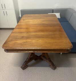
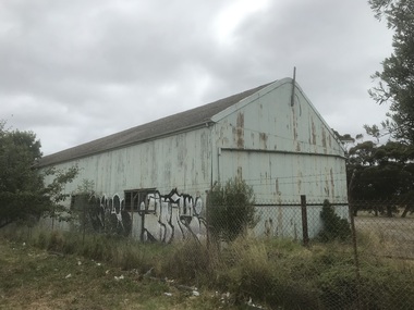
Functional object - Shire Of Braybrook Table
... Early settlement clustered around Solomon’s Ford on the Maribyrnong River, a key crossing for travelers heading to Geelong, Williamstown, and the goldfields. ...Early settlement clustered around Solomon’s Ford on the Maribyrnong River, a key crossing for travelers heading to Geelong, Williamstown, and the goldfields. ...The Shire of Braybrook (1871–1951) was a vast, semi‑rural municipality stretching from Melton to West Melbourne, centred on the old Braybrook village at Solomon’s Ford. It transformed dramatically with the arrival of railways, the rise of Braybrook Junction/Sunshine, and the industrial boom driven by H.V. McKay’s Harvester Works. The area was first organised as the Braybrook Road District on 28th May 1860, after a public meeting at the Shamrock Hotel in Albion. The district was enormous, extending from Melton to Dynon Road on the West Melbourne swamp. Early settlement clustered around Solomon’s Ford on the Maribyrnong River, a key crossing for travelers heading to Geelong, Williamstown, and the goldfields. On 23rd January 1871, the Road District became the Shire of Braybrook. Council meetings were initially held in Maidstone, reflecting the early population centres. The Braybrook Shire Hall in Deer Park was built in 1885. That 1885 building was the first official hall and council offices for the Shire of Braybrook, long before the municipality shifted its centre of gravity toward Sunshine. It stood near the Deer Park Hotel and served as the administrative heart of the shire during the late 19th century. The Braybrook Shire Hall at Deer Park effectively closed as a council headquarters in 1930, when the Shire of Braybrook shifted its administrative centre to Sunshine. In 1951, the Shire of Braybrook was renamed the City of Sunshine, reflecting the shift of population and industry eastward. In 1994 - 1995 the Kennett Government reduced Victoria’s councils from 210 to 78, the largest restructuring of local government in the state’s history and this part of the City of Sunshine became the City of Brimbank. It is believed this extension table came from the Shire of Braybrook Shire Office located in Ballarat Road, Deer Park, opposite the Deer Park Hotel. Over the years this extension table was used in the Shire of Braybrook Shire Office Ballarat Road Deer Park, the Shire of Braybrook and City of Sunshine Memorial Hall Hampshire Road Sunshine and in the City of Sunshine Municipal Offices Alexandra Avenue Sunshine. When the City of Sunshine Municipal Offices in Alexandra Avenue, Sunshine closed down, this table was were presented to the Sunshine & District Historical Society by the City of Brimbank. The table is still in use by the staff at The Hunt Club Community Arts Centre, Ballarat Road, Deer Park.This table is one of the few remaining items that still connects us to the early days of the Shire of Braybrook.Wood extension table with two extension leaves and carved legs.shire of braybrook, shire of braybrook offices, ballarat road, deer park -
 Sunshine and District Historical Society Incorporated
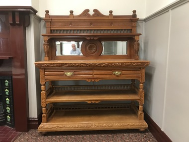
Functional object - Shire Of Braybrook Sideboard
... Early settlement clustered around Solomon’s Ford on the Maribyrnong River, a key crossing for travelers heading to Geelong, Williamstown, and the goldfields. ...Early settlement clustered around Solomon’s Ford on the Maribyrnong River, a key crossing for travelers heading to Geelong, Williamstown, and the goldfields. ...The Shire of Braybrook (1871–1951) was a vast, semi‑rural municipality stretching from Melton to West Melbourne, centred on the old Braybrook village at Solomon’s Ford. It transformed dramatically with the arrival of railways, the rise of Braybrook Junction/Sunshine, and the industrial boom driven by H.V. McKay’s Harvester Works. The area was first organised as the Braybrook Road District on 28th May 1860, after a public meeting at the Shamrock Hotel in Albion. The district was enormous, extending from Melton to Dynon Road on the West Melbourne swamp. Early settlement clustered around Solomon’s Ford on the Maribyrnong River, a key crossing for travelers heading to Geelong, Williamstown, and the goldfields. On 23rd January 1871, the Road District became the Shire of Braybrook. Council meetings were initially held in Maidstone, reflecting the early population centres. The Braybrook Shire Hall in Deer Park was built in 1885. That 1885 building was the first official hall and council offices for the Shire of Braybrook, long before the municipality shifted its centre of gravity toward Sunshine. It stood near the Deer Park Hotel and served as the administrative heart of the shire during the late 19th century. The Braybrook Shire Hall at Deer Park effectively closed as a council headquarters in 1930, when the Shire of Braybrook shifted its administrative centre to Sunshine. In 1951, the Shire of Braybrook was renamed the City of Sunshine, reflecting the shift of population and industry eastward. In 1994 - 1995 the Kennett Government reduced Victoria’s councils from 210 to 78, the largest restructuring of local government in the state’s history and this part of the City of Sunshine became the City of Brimbank. It is believed this extension table came from the Shire of Braybrook Shire Office located in Ballarat Road, Deer Park, opposite the Deer Park Hotel. Over the years this sideboard was used in the Shire of Braybrook Shire Office Ballarat Road Deer Park, the Shire of Braybrook and City of Sunshine Memorial Hall Hampshire Road Sunshine and in the City of Sunshine Municipal Offices Alexandra Avenue Sunshine where it was used in the Mayoral's council chambers. When the City of Sunshine Municipal Offices in Alexandra Avenue, Sunshine closed down, this sideboard was presented to the Sunshine & District Historical Society by the City of Brimbank.This sideboard is one of the few remaining items that still connects us to the early days of the Shire of Braybrook.French renaissance styled carved walnut sideboard with mirrored backplate.shire of braybrook, shire of braybrook offices, ballarat road, deer park -
 Sunshine and District Historical Society Incorporated
Photograph - Braybrook Photographs 2021, John Alchin, 2021
... River...Myalla Street...South Road...3LO Radio Transmitter...Central West Shopping Centre...National Springs...Ashley Hotel...ETA Factory...La Porchetta...Braybrook Hotel...Klipspringer...Harkrome...Steeden Engineering...Sunshine VRI Bowling Club...RecWest...Kinder Smith Reserve...Marj Laffin...Salvation Army Hall...Quang Minh Buddhist Temple...Burke Street...Ramon Vila Pavilion...Solomon Ford...5580.01 - Ashley St - Former 3LO - AWA Frequency changing building 2021 Photo 01.JPG 5580.02 - Ashley St 65- 67 Braybrook - Central West Shopping Centre 2021 Photo 02.JPG 5580.03 - Ashley St 185 - 195 Braybrook - Former National Springs 2021 Photo 01.JPG 5580.04 - Ballarat Rd 226 Braybrook - Ashley Hotel Ballarat Rd 2021 Photo 01.JPG 5580.05 - Ballarat Rd 234 Braybrook 2021 Photo 01.JPG 5580.06 - Ballarat Rd 234 Braybrook 2021 Photo 02.JPG 5580.07 - Ballarat Rd 244 - 246 Braybrook 2021 Photo 01.JPG 5580.08 - Ballarat Rd 256 Braybrook - ETA Factory Facade 2021 Photo 02.JPG 5580.09 - Ballarat Rd 256 Braybrook - ETA Factory Facade 2021 Photo 04.JPG 5580.10 - Ballarat Rd 261 Braybrook - La Porchetta 2021 Photo 01.JPG 5580.11 - Ballarat Rd 272 Braybrook - Former Holden Car Dealership 2021 Photo 01.JPG 5580.12 - Ballarat Rd 282 Braybrook 2021 Photo 02.JPG 5580.13 - Ballarat Rd 286 - 288 Braybrook 2021 Photo 01.JPG 5580.14 - Ballarat Rd 288 - 290 Braybrook 2021 Photo 01.JPG 5580.15 - Ballarat Rd 290 - 292 Braybrook 2021 Photo 01.JPG 5580.16 - Ballarat Rd 306 - 308 Braybrook 2021 Photo 01.JPG 5580.17 - Ballarat Rd 353 Braybrook - Braybrook Hotel 2021 Photo 01.JPG 5580.18 - Ballarat Rd 353 Braybrook - Braybrook Hotel 2021 Photo 02.JPG 5580.19 - Ballarat Rd 353 Braybrook - Braybrook Hotel 2021 Photo 03.JPG 5580.20 - Ballarat Rd 353 Braybrook - Braybrook Hotel Blue Stone Bar Sign 2021 Photo 01.JPG 5580.21 - Beachley St 23 - 33 Braybrook - Shops 2021 Photo 01.JPG 5580.22 - Beachley St 23 - 33 Braybrook - Shops 2021 Photo 02.JPG 5580.23 - Braybrook Commons Community Gardens Skinner Reserve 2021 Photo 01.JPG 5580.24 - Cranwell St 40 Braybrook - Klipspringer 2021 Photo 02.JPG 5580.25 - Darnley St 83 Braybrook 2021 Photo 01.JPG 5580.26 - Duke St 144 Braybrook 2021 Photo 01.JPG 5580.27 - Evans St 1 Braybrook - Harkrome Quality Electroplaters 2021 Photo 01.JPG 5580.28 - Evans St 9 Braybrook 2021 Photo 01.JPG 5580.29 - Gilbert St 8 Braybrrok - Steeden Engineering Co Pty Ltd 2021 Photo 01.JPG 5580.30 - Hampden St Factory Demolishment 2021 Photo 01.JPG 5580.31 - Kent St Braybrook - Sunshine VRI Bowling Club 2021 Photo 01.JPG 5580.32 - Kent St Braybrook - Sunshine VRI Bowling Club 2021 Photo 02.JPG 5580.33 - Kent St Braybrook - Sunshine VRI Bowling Club 2021 Photo 03.JPG 5580.34 - Lily st Braybrook - RecWest 2021 Photo 01.JPG 5580.35 - Maribyrnong River Temple to Temple Trail Sign 2021 Photo 01.JPG 5580.36 - Maribyrnong River Braybrook 2021 Photo 01.JPG 5580.37 - Marj Laffin Scoreboard Kinder Smith Reserve Lily St Braybrook 2021 Photo 01.JPG 5580.38 - Myalla St 40 Braybrook - Salvation Army Hall 2021 Photo 01.JPG 5580.39 - Myalla St 40 Braybrook - Salvation Army Hall 2021 Photo 02.JPG 5580.40 - Quang Minh Buddhist Temple Burke St Braybrook 2021 Photo 01.JPG 5580.41 - Quang Minh Buddhist Temple Gardens Braybrook 2021 Photo 04.JPG 5580.42 - Ramon Vila Pavilion Kinder Smith Reserve Lily St Braybrook 2021 Photo 01.JPG 5580.43 - Solomon Ford Maribyrnong River 2021 Photo 01.JPG 5580.44 - South Rd 204 Braybrook - Caroline Chisholm College Braybrook 2021 Photo 01.JPG 5580.45 - South Rd 204 Braybrook - Caroline Chisholm College Quinn Auditorium Braybrook 2021 Photo 01.JPG 5580.46 - William Barak Sign Duke St Reserve Braybrook 2021 Photo 01.JPG ...Ballarat Road Ashley Street Beachkey Street Cranwell Street Darnley Street Duke Street Evans Street Gilbert Street Hampden Street Kent Street Lily Street Maribyrnong River Myalla Street South Road 3LO Radio Transmitter Central West Shopping Centre National Springs Ashley Hotel ETA Factory La Porchetta Braybrook Hotel Klipspringer Harkrome Steeden Engineering Sunshine VRI Bowling Club RecWest Kinder Smith Reserve Marj Laffin Salvation Army Hall Quang Minh Buddhist Temple Burke Street Ramon Vila Pavilion Solomon Ford Caroline Chisholm College William Barak Aboriginal Aborigine First Nation Braybrook 5580.01 - Ashley St - Former 3LO - AWA Frequency changing building 2021 Photo 01.JPG 5580.02 - Ashley St 65- 67 Braybrook - Central West Shopping Centre 2021 Photo 02.JPG 5580.03 - Ashley St 185 - 195 Braybrook - Former National Springs 2021 Photo 01.JPG 5580.04 - Ballarat Rd 226 Braybrook - Ashley Hotel Ballarat Rd 2021 Photo 01.JPG 5580.05 - Ballarat Rd 234 Braybrook 2021 Photo 01.JPG 5580.06 - Ballarat Rd 234 Braybrook 2021 Photo 02.JPG 5580.07 - Ballarat Rd 244 - 246 Braybrook 2021 Photo 01.JPG 5580.08 - Ballarat Rd 256 Braybrook - ETA Factory Facade 2021 Photo 02.JPG 5580.09 - Ballarat Rd 256 Braybrook - ETA Factory Facade 2021 Photo 04.JPG 5580.10 - Ballarat Rd 261 Braybrook - La Porchetta 2021 Photo 01.JPG 5580.11 - Ballarat Rd 272 Braybrook - Former Holden Car Dealership 2021 Photo 01.JPG 5580.12 - Ballarat Rd 282 Braybrook 2021 Photo 02.JPG 5580.13 - Ballarat Rd 286 - 288 Braybrook 2021 Photo 01.JPG 5580.14 - Ballarat Rd 288 - 290 Braybrook 2021 Photo 01.JPG 5580.15 - Ballarat Rd 290 - 292 Braybrook 2021 Photo 01.JPG 5580.16 - Ballarat Rd 306 - 308 Braybrook 2021 Photo 01.JPG 5580.17 - Ballarat Rd 353 Braybrook - Braybrook Hotel 2021 Photo 01.JPG 5580.18 - Ballarat Rd 353 Braybrook - Braybrook Hotel 2021 Photo 02.JPG 5580.19 - Ballarat Rd 353 Braybrook - Braybrook Hotel 2021 Photo 03.JPG 5580.20 - Ballarat Rd 353 Braybrook - Braybrook Hotel Blue Stone Bar Sign 2021 Photo 01.JPG 5580.21 - Beachley St 23 - 33 Braybrook - Shops 2021 Photo 01.JPG 5580.22 - Beachley St 23 - 33 Braybrook - Shops 2021 Photo 02.JPG 5580.23 - Braybrook Commons Community Gardens Skinner Reserve 2021 Photo 01.JPG 5580.24 - Cranwell St 40 Braybrook - Klipspringer 2021 Photo 02.JPG 5580.25 - Darnley St 83 Braybrook 2021 Photo 01.JPG 5580.26 - Duke St 144 Braybrook 2021 Photo 01.JPG 5580.27 - Evans St 1 Braybrook - Harkrome Quality Electroplaters 2021 Photo 01.JPG 5580.28 - Evans St 9 Braybrook 2021 Photo 01.JPG 5580.29 - Gilbert St 8 Braybrrok - Steeden Engineering Co Pty Ltd 2021 Photo 01.JPG 5580.30 - Hampden St Factory Demolishment 2021 Photo 01.JPG 5580.31 - Kent St Braybrook - Sunshine VRI Bowling Club 2021 Photo 01.JPG 5580.32 - Kent St Braybrook - Sunshine VRI Bowling Club 2021 Photo 02.JPG 5580.33 - Kent St Braybrook - Sunshine VRI Bowling Club 2021 Photo 03.JPG 5580.34 - Lily st Braybrook - RecWest 2021 Photo 01.JPG 5580.35 - Maribyrnong River Temple to Temple Trail Sign 2021 Photo 01.JPG 5580.36 - Maribyrnong River Braybrook 2021 Photo 01.JPG 5580.37 - Marj Laffin Scoreboard Kinder Smith Reserve Lily St Braybrook 2021 Photo 01.JPG 5580.38 - Myalla St 40 Braybrook - Salvation Army Hall 2021 Photo 01.JPG 5580.39 - Myalla St 40 Braybrook - Salvation Army Hall 2021 Photo 02.JPG 5580.40 - Quang Minh Buddhist Temple Burke St Braybrook 2021 Photo 01.JPG 5580.41 - Quang Minh Buddhist Temple Gardens Braybrook 2021 Photo 04.JPG 5580.42 - Ramon Vila Pavilion Kinder Smith Reserve Lily St Braybrook 2021 Photo 01.JPG 5580.43 - Solomon Ford Maribyrnong River 2021 Photo 01.JPG 5580.44 - South Rd 204 Braybrook - Caroline Chisholm College Braybrook 2021 Photo 01.JPG 5580.45 - South Rd 204 Braybrook - Caroline Chisholm College Quinn Auditorium Braybrook 2021 Photo 01.JPG 5580.46 - William Barak Sign Duke St Reserve Braybrook 2021 Photo 01.JPG Collection of digital photographs Photograph Braybrook Photographs 2021 John Alchin ...Braybrook was originally part of the former Shire of Braybrook and later the City of Sunshine. However, in 1994, Victoria underwent council amalgamations, which resulted in Braybrook being incorporated into the City of Maribyrnong. The suburb of Braybrook continues to attract considerable attention from the residents of City of Brimbank, particularly its historical features, the old buildings and distinctive streetscapes that characterise the area.To capture the essence of Braybrook in 2021, a series of photographs were taken. These images document a range of buildings, street scenes, and other notable points of interest throughout the suburb, providing a visual record of its unique character.5580.01 - Ashley St - Former 3LO - AWA Frequency changing building 2021 Photo 01.JPG 5580.02 - Ashley St 65- 67 Braybrook - Central West Shopping Centre 2021 Photo 02.JPG 5580.03 - Ashley St 185 - 195 Braybrook - Former National Springs 2021 Photo 01.JPG 5580.04 - Ballarat Rd 226 Braybrook - Ashley Hotel Ballarat Rd 2021 Photo 01.JPG 5580.05 - Ballarat Rd 234 Braybrook 2021 Photo 01.JPG 5580.06 - Ballarat Rd 234 Braybrook 2021 Photo 02.JPG 5580.07 - Ballarat Rd 244 - 246 Braybrook 2021 Photo 01.JPG 5580.08 - Ballarat Rd 256 Braybrook - ETA Factory Facade 2021 Photo 02.JPG 5580.09 - Ballarat Rd 256 Braybrook - ETA Factory Facade 2021 Photo 04.JPG 5580.10 - Ballarat Rd 261 Braybrook - La Porchetta 2021 Photo 01.JPG 5580.11 - Ballarat Rd 272 Braybrook - Former Holden Car Dealership 2021 Photo 01.JPG 5580.12 - Ballarat Rd 282 Braybrook 2021 Photo 02.JPG 5580.13 - Ballarat Rd 286 - 288 Braybrook 2021 Photo 01.JPG 5580.14 - Ballarat Rd 288 - 290 Braybrook 2021 Photo 01.JPG 5580.15 - Ballarat Rd 290 - 292 Braybrook 2021 Photo 01.JPG 5580.16 - Ballarat Rd 306 - 308 Braybrook 2021 Photo 01.JPG 5580.17 - Ballarat Rd 353 Braybrook - Braybrook Hotel 2021 Photo 01.JPG 5580.18 - Ballarat Rd 353 Braybrook - Braybrook Hotel 2021 Photo 02.JPG 5580.19 - Ballarat Rd 353 Braybrook - Braybrook Hotel 2021 Photo 03.JPG 5580.20 - Ballarat Rd 353 Braybrook - Braybrook Hotel Blue Stone Bar Sign 2021 Photo 01.JPG 5580.21 - Beachley St 23 - 33 Braybrook - Shops 2021 Photo 01.JPG 5580.22 - Beachley St 23 - 33 Braybrook - Shops 2021 Photo 02.JPG 5580.23 - Braybrook Commons Community Gardens Skinner Reserve 2021 Photo 01.JPG 5580.24 - Cranwell St 40 Braybrook - Klipspringer 2021 Photo 02.JPG 5580.25 - Darnley St 83 Braybrook 2021 Photo 01.JPG 5580.26 - Duke St 144 Braybrook 2021 Photo 01.JPG 5580.27 - Evans St 1 Braybrook - Harkrome Quality Electroplaters 2021 Photo 01.JPG 5580.28 - Evans St 9 Braybrook 2021 Photo 01.JPG 5580.29 - Gilbert St 8 Braybrrok - Steeden Engineering Co Pty Ltd 2021 Photo 01.JPG 5580.30 - Hampden St Factory Demolishment 2021 Photo 01.JPG 5580.31 - Kent St Braybrook - Sunshine VRI Bowling Club 2021 Photo 01.JPG 5580.32 - Kent St Braybrook - Sunshine VRI Bowling Club 2021 Photo 02.JPG 5580.33 - Kent St Braybrook - Sunshine VRI Bowling Club 2021 Photo 03.JPG 5580.34 - Lily st Braybrook - RecWest 2021 Photo 01.JPG 5580.35 - Maribyrnong River Temple to Temple Trail Sign 2021 Photo 01.JPG 5580.36 - Maribyrnong River Braybrook 2021 Photo 01.JPG 5580.37 - Marj Laffin Scoreboard Kinder Smith Reserve Lily St Braybrook 2021 Photo 01.JPG 5580.38 - Myalla St 40 Braybrook - Salvation Army Hall 2021 Photo 01.JPG 5580.39 - Myalla St 40 Braybrook - Salvation Army Hall 2021 Photo 02.JPG 5580.40 - Quang Minh Buddhist Temple Burke St Braybrook 2021 Photo 01.JPG 5580.41 - Quang Minh Buddhist Temple Gardens Braybrook 2021 Photo 04.JPG 5580.42 - Ramon Vila Pavilion Kinder Smith Reserve Lily St Braybrook 2021 Photo 01.JPG 5580.43 - Solomon Ford Maribyrnong River 2021 Photo 01.JPG 5580.44 - South Rd 204 Braybrook - Caroline Chisholm College Braybrook 2021 Photo 01.JPG 5580.45 - South Rd 204 Braybrook - Caroline Chisholm College Quinn Auditorium Braybrook 2021 Photo 01.JPG 5580.46 - William Barak Sign Duke St Reserve Braybrook 2021 Photo 01.JPG ballarat road, ashley street, beachkey street, cranwell street, darnley street, duke street, evans street, gilbert street, hampden street, kent street, lily street, maribyrnong river, myalla street, south road, 3lo radio transmitter, central west shopping centre, national springs, ashley hotel, eta factory, la porchetta, braybrook hotel, klipspringer, harkrome, steeden engineering, sunshine vri bowling club, recwest, kinder smith reserve, marj laffin, salvation army hall, quang minh buddhist temple, burke street, ramon vila pavilion, solomon ford, caroline chisholm college, william barak, aboriginal, aborigine, first nation, braybrook -
 Sunshine and District Historical Society Incorporated
Photograph - Maribyrnong River and Valley
... Photocopy of Photograph Maribyrnong Munitions Factory 1938|Newspaper article Brimbank Messenger 29 October 2002 Our bond with the Maltese|Newspaper article The Herald Friday 24 February 1989 Yes Melbourne does have another river|Typed report History of Maribyrnong Steering Committee Reports|Typed notes of Steering Committee History of Maribyrnong Meeting held 7 June 1989|Typed notes 27 April 1989 History of Maribyrnong Steering Committtee Meeting|Typed notes of Steering Committee 5 April 1989|Typed notes of Steering Committee 1 March 1989|Typed notes of Steering Committee 11 January 1989|Typed notes 23 August 1988 Local History|Typed notes of Steering Committee 28 Febuary 1989|Typed report 17 November 1988 A History of Maribyrnong|Extract First Contacts I Primi Contenti|Extract Chapter 2 Maribyrnong on the map|Typed Report Migrant impact The early settlement of Maribyrnong|Photocopy of photographs Your family's photos are Maribyrnong's heritage|Typed report Maribyrnong A pictorial history|Typed report Maribyrnong History Outline|Typed report A History of Maribyrnong General Brief for the Author|Handwritten notes Research for Sunshine Council Project|Letter 18 August 1988 The History Institute|Typed report Copyright|Newspaper article Star 7 December 2004 Council moves to avert disaster|Newspaper article Brimbank Messenger 4 July 2000 Platypus potential|Newspaper article |Advocate 7 July 1993 New river bridge|Letter to Waterways and Parks division Metropolitan Parks 11 April 1985 Potential uses of Bluestone buildings|Typed Memorandum 21 January 1985 History of the Site of the Marie Hill Centre|Typed report The Ford Maribyrnong River|Typed letter from Legislative Council 6 January 1982 regarded rezoning|Extract of Poem The Haunted Castle at Maribyrnong by Martha Coxhead|Handwritten note Evan Crick Hotel dates|Brochure Historic Parkland Van Ness Avenue Sunshine|Typed notes Maribyrnong River Valley Braybrook February 1992|Typed letter 1 June 1983 Humes Site from Melbourne and Metropolitan Board of Works|Typed l etter 31 May 1982 from Historic Buildings Preservation Council re the fomer Melbourne Meat Preserving Company buildings and former Humes Pipes Site Van Ness Avenue Maribyrnong|Flyer 3 February 1803 Charles Grimes 175th Anniversary 5 February 1978|Newspaper articles Melbourne must not forget its other river|Newspaper article Sunshine Advocatge 24 February 1982 Hearing on Humes rezoning|Newspaper article Public Meeting on Future Development Plans for the former Humes site|Huge Banner Development Plan for Maribyrnong River|Newspaper article Advocate 22 February 2000 Greedy developers|Newspaper article Advocate 17 April 1996 River estate plan set for amendment|Newspaper article Advocate 8 February 2000 Bridging concern|Newspaper article Western Times 1 March 2000 Developers plan riles river residents|Newspaper article Advocate 20 February 1974 Maribyrnong a paradise|Newspaper article Messenger 15 February 2000 Plan rushed residents|Newspaper article Advocate 1 June 1983 Get tough policy on Valley|Newspaper article The Herald 11 December 1981 A community is up in arms over a threat to Victoria's heritage The battle over the bluestone. ...Maribyrnong River Maribyrnong Valley Photocopy of Photograph Maribyrnong Munitions Factory 1938|Newspaper article Brimbank Messenger 29 October 2002 Our bond with the Maltese|Newspaper article The Herald Friday 24 February 1989 Yes Melbourne does have another river|Typed report History of Maribyrnong Steering Committee Reports|Typed notes of Steering Committee History of Maribyrnong Meeting held 7 June 1989|Typed notes 27 April 1989 History of Maribyrnong Steering Committtee Meeting|Typed notes of Steering Committee 5 April 1989|Typed notes of Steering Committee 1 March 1989|Typed notes of Steering Committee 11 January 1989|Typed notes 23 August 1988 Local History|Typed notes of Steering Committee 28 Febuary 1989|Typed report 17 November 1988 A History of Maribyrnong|Extract First Contacts I Primi Contenti|Extract Chapter 2 Maribyrnong on the map|Typed Report Migrant impact The early settlement of Maribyrnong|Photocopy of photographs Your family's photos are Maribyrnong's heritage|Typed report Maribyrnong A pictorial history|Typed report Maribyrnong History Outline|Typed report A History of Maribyrnong General Brief for the Author|Handwritten notes Research for Sunshine Council Project|Letter 18 August 1988 The History Institute|Typed report Copyright|Newspaper article Star 7 December 2004 Council moves to avert disaster|Newspaper article Brimbank Messenger 4 July 2000 Platypus potential|Newspaper article |Advocate 7 July 1993 New river bridge|Letter to Waterways and Parks division Metropolitan Parks 11 April 1985 Potential uses of Bluestone buildings|Typed Memorandum 21 January 1985 History of the Site of the Marie Hill Centre|Typed report The Ford Maribyrnong River|Typed letter from Legislative Council 6 January 1982 regarded rezoning|Extract of Poem The Haunted Castle at Maribyrnong by Martha Coxhead|Handwritten note Evan Crick Hotel dates|Brochure Historic Parkland Van Ness Avenue Sunshine|Typed notes Maribyrnong River Valley Braybrook February 1992|Typed letter 1 June 1983 Humes Site from Melbourne and Metropolitan Board of Works|Typed l etter 31 May 1982 from Historic Buildings Preservation Council re the fomer Melbourne Meat Preserving Company buildings and former Humes Pipes Site Van Ness Avenue Maribyrnong|Flyer 3 February 1803 Charles Grimes 175th Anniversary 5 February 1978|Newspaper articles Melbourne must not forget its other river|Newspaper article Sunshine Advocatge 24 February 1982 Hearing on Humes rezoning|Newspaper article Public Meeting on Future Development Plans for the former Humes site|Huge Banner Development Plan for Maribyrnong River|Newspaper article Advocate 22 February 2000 Greedy developers|Newspaper article Advocate 17 April 1996 River estate plan set for amendment|Newspaper article Advocate 8 February 2000 Bridging concern|Newspaper article Western Times 1 March 2000 Developers plan riles river residents|Newspaper article Advocate 20 February 1974 Maribyrnong a paradise|Newspaper article Messenger 15 February 2000 Plan rushed residents|Newspaper article Advocate 1 June 1983 Get tough policy on Valley|Newspaper article The Herald 11 December 1981 A community is up in arms over a threat to Victoria's heritage The battle over the bluestone. ...Photocopy of Photograph Maribyrnong Munitions Factory 1938|Newspaper article Brimbank Messenger 29 October 2002 Our bond with the Maltese|Newspaper article The Herald Friday 24 February 1989 Yes Melbourne does have another river|Typed report History of Maribyrnong Steering Committee Reports|Typed notes of Steering Committee History of Maribyrnong Meeting held 7 June 1989|Typed notes 27 April 1989 History of Maribyrnong Steering Committtee Meeting|Typed notes of Steering Committee 5 April 1989|Typed notes of Steering Committee 1 March 1989|Typed notes of Steering Committee 11 January 1989|Typed notes 23 August 1988 Local History|Typed notes of Steering Committee 28 Febuary 1989|Typed report 17 November 1988 A History of Maribyrnong|Extract First Contacts I Primi Contenti|Extract Chapter 2 Maribyrnong on the map|Typed Report Migrant impact The early settlement of Maribyrnong|Photocopy of photographs Your family's photos are Maribyrnong's heritage|Typed report Maribyrnong A pictorial history|Typed report Maribyrnong History Outline|Typed report A History of Maribyrnong General Brief for the Author|Handwritten notes Research for Sunshine Council Project|Letter 18 August 1988 The History Institute|Typed report Copyright|Newspaper article Star 7 December 2004 Council moves to avert disaster|Newspaper article Brimbank Messenger 4 July 2000 Platypus potential|Newspaper article |Advocate 7 July 1993 New river bridge|Letter to Waterways and Parks division Metropolitan Parks 11 April 1985 Potential uses of Bluestone buildings|Typed Memorandum 21 January 1985 History of the Site of the Marie Hill Centre|Typed report The Ford Maribyrnong River|Typed letter from Legislative Council 6 January 1982 regarded rezoning|Extract of Poem The Haunted Castle at Maribyrnong by Martha Coxhead|Handwritten note Evan Crick Hotel dates|Brochure Historic Parkland Van Ness Avenue Sunshine|Typed notes Maribyrnong River Valley Braybrook February 1992|Typed letter 1 June 1983 Humes Site from Melbourne and Metropolitan Board of Works|Typed l etter 31 May 1982 from Historic Buildings Preservation Council re the fomer Melbourne Meat Preserving Company buildings and former Humes Pipes Site Van Ness Avenue Maribyrnong|Flyer 3 February 1803 Charles Grimes 175th Anniversary 5 February 1978|Newspaper articles Melbourne must not forget its other river|Newspaper article Sunshine Advocatge 24 February 1982 Hearing on Humes rezoning|Newspaper article Public Meeting on Future Development Plans for the former Humes site|Huge Banner Development Plan for Maribyrnong River|Newspaper article Advocate 22 February 2000 Greedy developers|Newspaper article Advocate 17 April 1996 River estate plan set for amendment|Newspaper article Advocate 8 February 2000 Bridging concern|Newspaper article Western Times 1 March 2000 Developers plan riles river residents|Newspaper article Advocate 20 February 1974 Maribyrnong a paradise|Newspaper article Messenger 15 February 2000 Plan rushed residents|Newspaper article Advocate 1 June 1983 Get tough policy on Valley|Newspaper article The Herald 11 December 1981 A community is up in arms over a threat to Victoria's heritage The battle over the bluestone. The Melbourne Meat Preserving Works|Typed report Historic Workplace Humes Site Van Ness Avenue Maribyrnong|Typed letter 1 December 1967 Explosives Factory Maribyrnong|Typed report Racing colours Rose and Black|Newspaper article The Age 28 April 1982 The western maze|Typed Minutes 4 July 1983 Meeting of the Lower Maribyrnong Conservation Group|Typed Constitution of the Lower Maribyrnong Valley Conservation Group|Typed Submission 29 April 1982 To City of Sunshine for Historic buildings preservation council classifications sub committee|Typed Minutes of Lower Maribyrnong Valley Conservation Group 26 August 1982|Typed Application for Membership form Lower Maribyrnong Valley Conservation Group|Typed Submission for a Financial Grant to the Charles Grimes 175th Anniversary Re enactment Committee|Typed Annual General Meeting 5 July 1984 Lower Maribyrnong Valley Conservation Group|Typed letter 30 July 1980 Humes Site|Typed Proposal Bluestone building|Typed Letter from University of Melbourne 11 December 1980 Meat Preserving companys works|Brochure Pipemakers Park|Typed notes Elizabeth McKinnon Mosaic mural artist|Newspaper article Sunshine Advocate 10 November 1993 Heritage site rediscovered|Newspaper article The Age 7 September 1996 Dreamtime in an industrial garden|Newspaper article The Western Times 6 December 1989 The peoples historiian|Typed report The Saltwater River Powder Magazine Jacks Magazine|Typed letter from Henry Laskowski Sunshine City Council Engineer / Planner to Gwen Goedecke Re: Melbourne Metropolitan Planning Scheme Amendment No 157 Maribyrnong Valley 26th November 1981|Newspaper article The Advocate 13th September Council to buy vital river land|Newspaper article The Age 4th September 1978 Tight controls urged over Maribyrnong|Newspaper article The Age 27th April 1988 Metropolitan Region Planning Scheme Amendment RL11|Melbourne Metropolitan Board of Works M.M.B.W. Concept plan for Maribyrnong River Development Media Release 25th January 1984|City of Sunshine The Maribyrnong River Ideas for the River Valley|Newspaper Article The Advocate 14 March 1979 River Valley Land Purchasemaribyrnong river, maribyrnong valley -
 Stawell Historical Society Inc
Photograph, Whitehall Property Greens Creek
... river on the left. 31. Whitehall from the side. Building in centre behind David is separater room. 2 roomed hut to left of separater room and remains of mens' hut chimney. Photo 16 taken from similar spot. 20 Sep 1992 32. Benjamin Roe (Col Hutchings grandson) in the Carpenters' shop. The family lived in this building after the fire in the 1870's. Whitehall 20 Sep 1992 33. Ford...river on the left. 31. Whitehall from the side. Building in centre behind David is separater room. 2 roomed hut to left of separater room and remains of mens' hut chimney. Photo 16 taken from similar spot. 20 Sep 1992 32. Benjamin Roe (Col Hutchings grandson) in the Carpenters' shop. The family lived in this building after the fire in the 1870's. Whitehall 20 Sep 1992 33. Ford ...Hutchings family 1. Wimmera River in flood below Whitehall running a banker c. 1920. Ted & Col Hutchings in foreground. 2. Wimmera River in flood looking downstream. No date but possibly same time as no. 1. from same place. 3. Looking over the Wimmera River to Island paddock towards Greens Creek 4. Wimmera River half a banker at Whitehall 5. Wimmera River in flood upstream from carpenter's shop looking towards engine house at Whitehall 5a. Wimmera River in flood. Left to right - blacksmith shop and carpenters' shop. 5b. Taken from the same spot with Emily & Ada Hole, E G (Ted) & Col Hutchings. Blacksmith shop & carpenters' shop, Whitehall. 5c. Wimmera River upstream from the carpenters' shop. Foreground is possibly Belladonna lilies which were all over the river bank in 1992. Whitehall. 5d. Looking downstream towards the loose boxes, Whitehall. 5e. Blacksmiths' shop and carpenters' shop from the pumping station. Wimmera River, Whitehall. 6. Wimmera River in flood at Whitehall. 7. Wimmera River half a banker in front of old hut at Whitehall. 8. Wimmera River Emily Hayes, Edward G (Ted) Hutchings & Colin J Hutchings. 9. Morrl-Morrl - Greens Creek Road opposite back paddock. Whitehall. Black Ford in distance. c. 1919 10. Whitehall woolshed north east aspect, Drive to the right of photo 11. Whitehall woolshed - north east aspect showing the drive to the right 11a. Whitehall woolshed - north aspect 11b. Same tree near woolshed 11c. Same tree again in centre, other trees came up after the 23 flood. Woolshed to the right out of photo. 12. Whitehall woolshed - south aspect, sheep entrance end 13. Whitehall. left to right, Stackyard, stables in the centre and the Wimmera River behind following the trees. 14. Whitehall horse paddock c. 1920. left to right, Machinery shed, stable in the centre. Homestead to the right in distance. There is no windmill. 15. Load of wool from Whitehall woolshed to right. 16. Whitehall c. 1920 before the windmill. left to right, garage and mens' hut. Wimmera river runs along the tree line. 16a. Stables, garage and mens' hut after the construction of the windmill. River behind. 17. Whitehall c. 1922. Note windmill addition. Garage to left, Mens' Hut to right. Jack Donnelly & Edward G (Ted) Hutchings with pet lambs. River behind trees. 18. Whitehall gardens. Summer house to the right, pine tree lined drive in the centre background. Ted & Col Hutchings on the lawn. C. 1920 19. Edward G. (Ted) & Colin J. Hutchings in Whitehall garden. Wimmera River in the background. The building behind the fence is the carpenters' shop which the family lived in while house was rebuilt after fire 15 Jan 1877 20. Whitehall c. 1920. left to right, cattle yard, killing house, Wimmera river behind the fence, and the loose box on the right. Black Orpington chooks in foreground. 21. Bay window (original blinds) in the master bedroom. Whitehall 20 Sep 1992 22. Master bedroom (original wallpaper) Joyce & Col Hutchings, Moyu, Ben & Rebecca Roe 20 Sep 1992 23. Col & Ted's bedroom (original) Marble mantlepiece had been removed. Whitehall. 20 Sep 1992 24. Whitehall kitchen. Large yellow meat oven to left of stove, bread oven far left, extreme right is oven where milk heated to skim cream. Chimney was a central one shared with meat oven. Bread oven chimney separate. 20 Sep 1992 25. Whitehall dairy, made of natural stone with dried brick corners. Entrance behind creeper which is over trellis. 20 Sep 1992. This building still remains in 1 Jun 2023 26. Inside charcoal lined meat cellar. Bottom right is concrete vat for pickling meat in brine. Top of brickwork slightly above ground level. Whitehall 20 Sep 1992 27. Fire foreground was stable flooring which was to left of photo. Machinery shed (thatch roof). 4 posts far left remains of cowshed. Large post in centre foreground is the gate post of corral. River to right. 20 Sep 1992 28. Whitehall machinery shed. Posts on far right are cow shed. Over the river is the island paddock. Wimmera river runs behind machinery shed. 20 Sep 1992 29. Posts of 10 sided corral. Killing house by side of gum tree in centre of photo on far side of corral. To left is one of the bales of the cowshed. Whitehall. 20 Sep 1992 29a. Similar photo in the 1920's. To the right is horsebreaking corral, then cow shed, loose box, haystacks and stable on left. Whitehall. 30. Dining room fire place put in the open fire of the mens' hut, only the chimney remains. To the left is the drive & river. Rebecca Roe, Col Hutchings granddaughter. 20 Sep 1992 30a. Looking down the Whitehall Drive. Mens' Hut (Jack Donnelly in doorway) and garage far left. 1920's 30b. The Drive, Whitehall taken from in front of the mens' hut. Wimmera River on the left. Gum tree on left still there 20 Sep 1992. 30c. Reverse from 30a. Whitehall drive from the front gate looking towards the mens' hut and garage. c. 1926 30d. Curly Donohue leaving for Warracknabeal. Ex mail contractor Omeo to Bright Victoria. C. 1926 30e. Looking down the drive towards front gate. Mens' hut on the right, river on the left. 31. Whitehall from the side. Building in centre behind David is separater room. 2 roomed hut to left of separater room and remains of mens' hut chimney. Photo 16 taken from similar spot. 20 Sep 1992 32. Benjamin Roe (Col Hutchings grandson) in the Carpenters' shop. The family lived in this building after the fire in the 1870's. Whitehall 20 Sep 1992 33. Ford across the Wimmera River at Whitehall (River abt. 5 feet higher than normal) 20 Sep 1992 33a. Wimmera River, Whitehall 34. Site of old bridge before Col Hutchings time. Tree in foreground to right still has bolt from bridge work protuding. A large post was in the centre of photo to make equal distance. 20 Sep 1992 35. Entrance to the old ford. Colin J Hutchings & his daughter, Moyu Roe. Wimmera River, Whitehall 20 Sep 1992 36. Summer house at Whitehall 20 Sep 1992 looking down to the orchard, dark green trees in distance old fruit trees. 36a. Edward & Colin Hutchings in front of the Summer house, Whitehall c. 1921 36b. Summer house looking towards front gate. Whitehall. 36c. Grey thrush in nest box which can be seen in previous photo with summer house in the background. Whitehall. 36d. Summer house from the orchard side. Whitehall. 37a. South side of Whitehall. First window Edith Sutherland's room, 2nd window, Ted & Col's room, bay window master bedroom 38. Taken in middle of front path looking towards front gate. Edith Sutherland in garden. Date palm in centre, cotton palm to left. Whitehall c. 1920's 38a. Garden at Whitehall taken from near the cotton palm. 39. Whitehall 20 Sep 1992 Bay window-master bed, small window to r. of bay-Colin Hutchings born in, front door, window to right-dining room, round the corner- drawing room, window on right, spare bed, verandah on left is spare bed. 39a. Whitehall c. 1920's Date palm on the right. 39b. Win, Colin T & Colin J Hutchings. Date palm in background. Whitehall 1943 39c. Edward George, Colin Thomas, Elizabeth Ambler & Colin James Hutchings wearing RAAF uniform. Date Palm in background. Whitehall c. 1943 39c. Front garden of Whitehall looking from the front right side of the house towards the drive & Wimmera River. Date palm on right, cotton palm on left 20 Sep 1992 40. Taken from bottom left corner of front garden looking towards the summer house. Cotton palm on right. River to the left. 41. Elizabeth A Hutchings beside master bedroom window. Whitehall c. 1920 42. Whitehall (photo of a painting by Wallace) owned by Colin T Hutchings 1982. 42a. Whitehall painting by Wallace after restoration now owned by Nick Hutchings 2021 42b. Whitehall c. 1923 42c. Taken from the side garden looking towards the right side of house. Front door is to the left out of photo. The cotton palm is to the left. c. 1923 43. Signpost showing Whitehall 20 Sep 1992, All ground up to the tree line behind the signpost was Whitehall property. 44. Colin T. Hutchings age 9 mths. Mar 1943 Whitehall 45. Colin James, Elizabeth Ambler & Edward George Hutchings. Front garden by the date palm, Whitehall c. 1939-40 45a. Colin James, Edward George, Edward Thomas Hutchings & E. Winifred May & Barney (dog) Whitehall. c. 1939-40. 45b. Colin James & Colin Thomas Hutchings during drought & World War ll c. 1944-45 in front of cotton palm, date palm to right. 46. Garden at Whitehall. Jack Donnelly on the hand mower. Cotton palm on left, date palm behind Jack and roof of carpenters shop to right. 47. Colin J Hutchings on tractor, E. Tom Hutchings behind. Whitehall, c. 1933 48. Jack Donnelly (Tad) & Colin J. Hutchings. Cotton palm to right. Whitehall c. 1917-18 49. Edward G (Ted) & Colin J Hutchings with cockatoo outside the dairy in rear garden. Whitehall c. 1923 50. Taken from the windmill looking across the roof of the mens' hut to the garden, orchard and drive in Winter time. House is behind the trees to right, Wimmera River to the left out of picture. Whitehall. 50a. Not labelled by Col Hutchings. It is an aerial shot looking towards the house in the trees & seems to be taken from the top of a tree...on the river side. 51. E. Tom Hutchings & George Chambers dam sinking. Whitehall. 51a. Tom Hutchings & George Chambers dam sinking. Whitehall. 51b. E. Tom Hutchings dam sinking. 52. Emily Hayes & Ada Hole (sisters) with Tom, Col & Ted Hutchings at the woolshed. 53. E T (Tom) Hutchings on reaper & binder. Whitehall. 54. Orchard looking towards the house. Carpenters' shop and river on the right. Whitehall. 54a. Orchard looking from the house, dark trees in background form part of the drive. 55. Grasshopper plague, Christmas Day 1933. Whitehall 56. Frost on the front lawn, Whitehall. 57. Little red hen & chicks with the river in the background 58. Edward (Ted) G. Hutchings muscovy ducks, hay shed and trees along the river in the background. 58a. Edward (Ted) G Hutchings muscovy ducks. 59. Swimming in the Wimmera River, either Ted or Col Hutchings in the foreground. 60. Looking towards the fowl house and pigsty, Whitehall. 61. Snake on the path, Whitehall. c. 1923 61a. E. Tom Hutchings killing a snake, Whitehall. c. 1923 61b. E. Tom Hutchings killing a snake, Whitehall. c. 1923 62. Notice of clearing sale, Stawell News & Pleasant Creek Chronicle on 5 Apr 1916 where the stock & whole of the household furniture was to be sold by James Hutchings widow. 63. Back to Greens Creek 7 Jun 1987 Colin J Hutchings left and Belle Kindred centre looking at photo 64. Back to Greens Creek 7 Jun 1987 Colin J Hutchings centre, Graham Stewart holding photograph on the right. 65. Colin J Hutchings & Bill Walker. Back to Greens Creek 7 Jun 1987 66. Colin J Hutchings delivering a speech before the plaque unveiling. Back to Greens Creek 7 Jun 1987 67. Graeme Williamson & Colin J Hutchings (2 'old boys') Greens Creek School Site 7 Jun 1987 68. Graeme Williamson talking to Moyu Roe (Hutchings) in background is May Williamson. Back to Greens Creek 7 Jun 1987 69. Greens Creek SS, Edward (Ted) & Colin J Hutchings attended. 70. Original students of first Greens Creek School 7 Jun 1987 Back row left 1. Kindred 3. Colin J Hutchings 4,5,6 not known 7. Graeme Williamson Sitting left 1. Not an original 2,3,4, not known 5. Belle Kindred 71. Terrier at Greens Creek State School 72. The new school students Back to Greens Creek 7 Jun 1987. Perry twins standing in centre and the teacher kneeling front left. 73. Will Rees water colour 1925 signature 74. Will Rees water colour 1925 75. Shearing at Kirkellar. Allen Simpson's 76. Back to Greens Creek 7 Jun 1987 Colin J Hutchings left and Belle Kindred centre looking at photo 77. Back to Greens Creek 7 Jun 1987 Colin J Hutchings centre, Graham Stewart holding photograph on the right. 78. Colin J Hutchings & Bill Walker. Back to Greens Creek 7 Jun 1987 79. Colin J Hutchings delivering a speech before the plaque unveiling. Back to Greens Creek 7 Jun 1987 80. Graeme Williamson & Colin J Hutchings (2 'old boys') Greens Creek School Site 7 Jun 1987 81. Graeme Williamson talking to Moyu Roe (Hutchings) in background is May Williamson. Back to Greens Creek 7 Jun 1987 82. Greens Creek SS, Edward (Ted) & Colin J Hutchings attended. 83. Original students of first Greens Creek School 7 Jun 1987 Back row left 1. Kindred 3. Colin J Hutchings 4,5,6 not known 7. Graeme Williamson Sitting left 1. Not an original 2,3,4, not known 5. Belle Kindred 84. Shearing at Kirkellar. Allen Simpson's 85. Terrier at Greens Creek State School 86. The new school students Back to Greens Creek 7 Jun 1987. Perry twins standing in centre and the teacher kneeling front left. Digital Copy of Parish Maps Kara Karahomestead -
 Warrnambool and District Historical Society Inc.
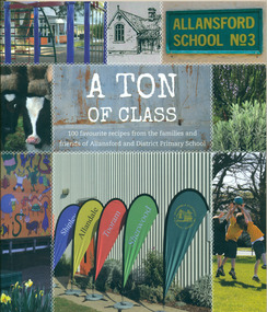
Book, A Ton of Class: 100 favourite recipes from the families and friends of Allansford and District Primary School, 2014
... In an attempt to recoup some of the heavy losses due to the disastrous Bateman fire of 1854 John subdivided a portion of Tooram at the Hopkins River crossing known as Allans ford. A school reserve was included in this subdivision. ...In an attempt to recoup some of the heavy losses due to the disastrous Bateman fire of 1854 John subdivided a portion of Tooram at the Hopkins River crossing known as Allans ford. A school reserve was included in this subdivision. ...This cookery book was produced in 2014 as a school fundraiser. It was purchased at Allansford Cheese World in January 2015 for $15. Allansford school was established as a National School in 1856 on land reserved for the purpose by John McMahon Allan. It comprised two sandstone classrooms -one for boys and one for girls -with an attached pise teacher's residence. In 1872 when the Victorian Education Department was set up existing schools were listed in alphabetical order and given a number. Allansford State School was No.3. The school was enlarged in the late 1800s and again in the early 1920s. In 1994 following the amalgamation of the Allansford, Allans Forest and Naringal schools a new school was built which adjoined the existing buildings. The old buildings were refurbished as administration and staff facilities. John McMahon Allan settled in the area in 1839 with his brother William Osborne Allan. They were the sons of David Allan, Deputy Commissary General during Macquarie's term of government. The brothers divided the station with William retaining the Allandale portion and John naming his portion Tooram. John McMahon Allan was president of the early district Roads Board. In an attempt to recoup some of the heavy losses due to the disastrous Bateman fire of 1854 John subdivided a portion of Tooram at the Hopkins River crossing known as Allans ford. A school reserve was included in this subdivision. Source: McLeod, Graeme & Barbara. Allansford 1855-2006This book has social and historical interest and significance as it is connected to a local school. It provides a snapshot of food and cooking methods in the early 21st cebturyCookery book with full colour cover featuring 8 photographs and drawings of the Allansford Primary School surrounds and pupil activities. The images are 'stitched' together with a white zig-zag diamond pattern as if a quilt. The foldout cover has an image of the school's centenary memorial gates and a brief history of the school. Inside the foldout are images of the pupils in each of the school's four team houses. The foldout back cover has full colour images of pupils performing at the school concert. A white strip noting 'our values' is included on the inside back cover foldout. Soft cover, 112 pages.allansford school, a ton of class, allansford primary school, a ton of class recipe book -
Marysville & District Historical Society
THE TRIANGLE NEWS-VOL 39 NO 26-JULY 13 2012
... ford...church notices...parkinsons victoria ambassadors of hope...marysville golf report...goulburn river...Marysville & District Historical Society 39 Darwin Street Marysville yarra-valley-and-the-dandenong-ranges marysville victoria australia loan subsidies still on offer for marysville & triangle marysville & triangle investment subsidary for affected bushfire areas regional arts fund steel pan bands receiving funding for international festivals what's on when in july the committee of management of the gallipoli park precinct marysville community market creative triangle murrindindi shire council shire tennis club growth support alexandra junior soccer club advertisements vale stephen franzi-ford church notices parkinsons victoria ambassadors of hope marysville golf report goulburn river high country rail trail rising power and gas bills marysville pharmacy marysville medical clinic mayor's chair adventurous cooks marysville community golf & bowls club trivia and pasta intrepid triangle bushwalkers sample wines alexandra library midnight express dance taggerty hall alexandra cinema real estate council's rating review strategy yea council chambers lake mountain alpine resort ann thoma 1995 reflections on history marysville & district historical society national emergency medal nominations marysviile steel band festival 2013 THE TRIANGLE NEWS-VOL 39 NO 26-JULY 13 2012 ...marysville, victoria, australia, loan subsidies still on offer for marysville & triangle, marysville & triangle investment subsidary for affected bushfire areas, regional arts fund, steel pan bands receiving funding for international festivals, what's on when in july, the committee of management of the gallipoli park precinct, marysville community market, creative triangle, murrindindi shire council, shire tennis club growth support, alexandra junior soccer club, advertisements, vale stephen franzi-ford, church notices, parkinsons victoria ambassadors of hope, marysville golf report, goulburn river high country rail trail, rising power and gas bills, marysville pharmacy, marysville medical clinic, mayor's chair, adventurous cooks, marysville community golf & bowls club, trivia and pasta, intrepid triangle bushwalkers, sample wines, alexandra library, midnight express dance, taggerty hall, alexandra cinema, real estate, council's rating review strategy, yea council chambers, lake mountain alpine resort, ann thoma 1995 reflections on history, marysville & district historical society, national emergency medal nominations, marysviile steel band festival 2013 -
 Lara RSL Sub Branch
Photograph, Set 4 photographs. and others for Torquay Light Horse camp, 1940
... They arrived at the Geelong racecourse for watering in the Barwon River and then were ridden across the ford at the breakwater and began their 11 mile trek to Torquay. ...They arrived at the Geelong racecourse for watering in the Barwon River and then were ridden across the ford at the breakwater and began their 11 mile trek to Torquay. ...These images capture for all time Light Horsemen travelling through Geelong on their way to camp at Torquay for the last Group meeting in Australia . information following - details obtained from .........https://torquayhistory.com/light-horse-brigade/ On Australia Day, 1997, Sir John Young unveiled this plaque on Point Danger, Torquay. Torquay history, Light Horse Training Camp, WW2 Plaque at Pt. Danger Note----- (See images to view plaque) The plaque identifies a significant event in Torquay’s history and the sentiments of ‘change’ for the Light Horse Brigade – from horses to machines. In 1940 the four Light Horse Regiments (4th, 8th, 13th and 20th), some 5000 Light Horse and 2000 horses camped and trained at Torquay. Three other regiments, formerly mounted on horses, were also at Torquay ‘mounted’ on privately owned trucks and cars. Division troops included Artillery, Engineers, Signals, Field Ambulance and other branches of the Army necessary to enable a Division to function. It wasn’t just the sheer numbers of men coming to this little town that made the event significant, it was also the fact that the men of the Light Horse were dramatic, almost glamorous figures and it is easy to see their exploits as some splendid adventure. Horses have played a special role in the story of Australia. They were the only means of transport across this huge country, so it was necessary for everyone to have the ability to ride a horse. When war broke out in 1899 between Britain and the Boers of South Africa (“Boer” was Dutch for “farmer”) Australia sent troops to fight. At first Britain was wary of using untried, unprofessional colonial cavalrymen but soon saw that the slouch-hatted Australian “bushmen” were a match for the fast-moving and unconventional mounted commandos of the Boers. The Australians proved themselves to be expert rough-riding horsemen and good shots. Bush life had hardened them to go for long periods with little food and water. They also showed remarkable ability to find their way in a strange country and use its features for cover, in both attack and defence. By 1914, when Australia joined the war against Germany, there were 23 Light Horse regiments of militia volunteers. Many men from these units joined the Light Horse regiments of the Australian Imperial Force (AIF). Men were given remounts (if not using their own horses) – army horses bought by Commonwealth purchasing officers from graziers and breeders. These were called “walers” because they were a New South Wales stockhorse type – strong, great-hearted animals with the strains of the thoroughbred and semi-draught to give them speed, strength and stamina. On 1st November, 1914, Australia’s First Infantry Division and the first four Light Horse regiments sailed for England in a fleet of transport ships. The first of the Light Horse arrived at Gallipoli in May without their horses. Back with their horses after Gallipoli, they were formidable combatants across the Sinai and Palestine. Some British commanders observed that the light horseman moved with a “lazy, slouching gait, like that of a sleepy tiger” but described how the promise of battle “changes that careless gait, into a live athletic swing that takes him over the ground much quicker than other troops”. They had Light Horse, Torquay, training campdeveloped a reputation as formidable infantrymen. The Turks called them “the White Ghurkas” – a reference to their deadly skill with the bayonet. The Arabs called them “The Kings of the Feathers”. The plume had originally been a battle honour of the Queensland Mounted Infantry for their work in the shearer’s strike of 1891. During WW1 it was adopted by almost all the Light Horse Regiments. It was the proud badge of the light horseman. The most famous of their battles was the attack on Beersheba- the charge of the 4th Light Horse Brigade. Mounted infantrymen and their superb walers had carried out one of the most successful cavalry charges in history – against what seemed impossible odds. They surprised the Turks by charging cavalry-style, when they would normally have ridden close to an objective then dismounted to fight. The fall of Beersheba swung the battle tide against the Turks in Palestine; and changed the history of the Middle East. While 19 men from the Surf Coast Shire served with the 4th Light Horse over the course of WW1, only four were involved in the charge of Beersheba- John GAYLARD, Philip QUINN.(Winchelsea); Wallace FINDLAY (Anglesea); Harry TRIGG (Bambra). After the war, Light Horse units played a key role in the Australian Government’s compulsory military training programme. The Citizen Military Forces (C.M.F.) thrived on the glamour of the wartime Light Horse tradition, ignoring the possibility that motor vehicles would soon replace the horses. When training was no longer compulsory, the C.M.F. regiments declined and horses became more of a luxury during the 1930s depression years of poverty and unemployment. Some regiments were motorised. Then, in 1939, Australia joined Britain in another world war. Training was increased for the militia at both home bases and regional training camps. The camp at Torquay in 1940, commanded by Major General Rankin, was at Divisional strength. By the end of the camp some felt that the Division was ready for active service. Gradually, over the next four years, the Australian Light Horse units were mounted on wheels and tracks and the horses were retired. Six men enlisted at the Torquay camp and another 57 men and women enlisted at Torquay for service in WW2. Those who served in the Militia provided valuable Officers and NCOs and men for the armed services during the war. Each infantry division of the 2nd AIF had a Light Horse regiment attached to it. But the day of the Australian mounted soldier hadn’t quite passed. During World War II, Australia’s 6th Cavalry Regiment formed a mounted unit they called “The Kelly Gang” which did valuable scouting work. In New Guinea, a mounted Light Horse Troop did patrol duty and helped carry supplies. Some fully equipped walers were flown into Borneo for reconnaissance in rugged mountain country. But by the end of the war, in 1945, the horse had disappeared from the Australian Army. References: Australian Light Horse Association www.lighthorse.org.au National Australia Archives Australian War Memorial Surf Coast Shire WW1 memorials www.togethertheyserved.com The Light horse- a Cavalry under Canvas Light Horse, Training Camp, Torquay, WW2 Late in 1939 it was decided to set up a Lighthorse training camp in Torquay to train both men and horses for the battles of the Second World War. Horses, men and equipment came on special trains from all over Victoria and NSW, and as you would expect horseman came from areas such as Omeo and Sale, the Wimmera and the Western District. They arrived at the Geelong racecourse for watering in the Barwon River and then were ridden across the ford at the breakwater and began their 11 mile trek to Torquay. Light Horse, Training Camp, Torquay, WW2 Tent city By the end of January 1940 the camp at Torquay accommodated some 5000 men and 2500 horses of the Second Cavalry Division. The rows of horses, tents and huts near Blackgate Road were quite a sight. While the cavalrymen engaged in exercises on the land and on the beaches, many of the troops took over the Torquay School for special training of men and officers. Mr Bob Pettit local farmer and Councillor for the Barrabool Shire, wrote about the Light horse in the Surf Coast Community News in 1985 saying “They used to travel about the district riding four abreast in one long convoy. To my annoyance they went through my property and shut all the gates behind them. I had certain gates open to let stock in to the water holes and it would take me three -quarters of an hour to follow the horsemen up and put all the gates right again” he continued “the men from the Light Horse were here when the fire went through in March 1940. He recalled an incident when early one morning, as some one blew the bugle, a soldier putting a white sheet on the line frightened the horses. They panicked and ran off in all directions. Six went over the cliff near Bird Rock, five were never found, and the rest were gathered up after nearly a fortnight in the bush around Addiscott and Anglesea" Light Horse, Training Camp, Torquay, WW2, Geelong Parade Geelong parade The training camp culminated in a parade through the streets of Geelong on March 12th 1940. The salute was given at the Town Hall and the troops continued on a route to the You Yang’s for a training exercise. Note-----(see media section for photograph) The Camp was abandoned in mid 1940 as it was deemed unsuitable for training during winter and the cost of a permanent camp could not be justified if it could not be used all year. Historic.......Rare,,,Interpretive.Sepia photographs.set of four ....post card size ....Horses &LighthorsemenNo 1, Lighthorsemen Regiment Geelong 1940......No 2 Light Horse at Breakwater Geelong 1938 to 1940....No 3 Light Horse at Breakwater Geelong 1938 to 1940.....No 4 Light Horse crossing Breakwater camped at Geelong Showgrounds. These markings are on reverse of photographs.light horsemengeelong 1940., world war 2 -
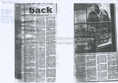 Eltham District Historical Society Inc
Document - Photocopy, Diamond Valley News, Newspaper article: Fred looks back by Linley Hartley, Diamond Valley News, c.1985
... There was no bridge in Fitzsimons Lane but we used to cross the river at a ford, rolling up our trouser legs so they wouldn’t get wet, and carrying our shoes. ...There was no bridge in Fitzsimons Lane but we used to cross the river at a ford, rolling up our trouser legs so they wouldn’t get wet, and carrying our shoes. ...Fred looks back; Report: Linley Hartley, Picture: Ron Grant Teaching himself German again after 70 years is just one of the many tasks Fred Golgerth, of Greensborough, has undertaken and succeeded in during his lifetime. As the two year old tenth child of a German descendent, Fred learnt to speak German from an Aunt. But World War 1 was raging. Fred’s older brother had gone to Europe with the Australian forces, changing his name … to ….. to sound less German. “I used to get my bottom slapped for speaking German at home,” Fred said. Even his name was changed from Otto to the more anglicised Frederick. Fred claims his involvement with Eltham started two years before he was born! His sister, two years older than him, was a babe in arms when his parents bought a piece of grazing property in Mount Pleasant Rd. “It was about 24 acres on a spur of Mt Pleasant,” Fred said. “My parents bought it from Mr and Mrs Hughes. There was a two-room mud hut in wattle and daub that we lived in from time to time. “My parents had a dairy farm and dairy in West Coburg, and they bought the Mt Pleasant land to put the dry stock on. “At one stage my mother got very ill and my older sister took my younger sister and myself to Eltham for four or five months. I went down to Eltham Primary School then.” That wasn’t the only time Fred stayed in Eltham. His sister, Wilhemina, known as Willa, married Jim Watson who had the Eltham hotel for some years from the end of World War 1. Pillar to post living was the way Fred described his youth, when he stayed with one married sister after another. “After a while Will and Jim lived in the big house at the top of Pitt St, next to the Council depot, and the hotel was managed by Fitzsimmons who had a big place near the river down there on Fitzsimons Lane. There was no bridge in Fitzsimons Lane but we used to cross the river at a ford, rolling up our trouser legs so they wouldn’t get wet, and carrying our shoes. I’d o down to visit some friends I had in Templestowe. And sometimes Jim Watson took his horse drawn lorry across the ford on his way to the brewery, instead of going don through Heidelberg.” “The bridge across the Yarra in Fitzsimons was not built until 1961.” Fred Golgerth, was only a teenager when he was rolled off his pushbike under a car on the bend between Mt Pleasant Rd and the Diamond Creek bridge. He was hospitalised in the little hospital on the east side of Eltham village that served the district in those days. He still carries the scars of the burns he received from the exhaust pipe and recent x-rays have revealed several broken vertebrae. At the time of the accident he was treated for a dislocated neck and was in plaster from his hip to the base of his head for about seven months. But nothing daunted Fred. Bouncing back he began work as an apprentice to a motor mechanic in Bell St, Preston, a man who is still living (at 90) in Queensland and who still communicates with Fred frequently. “He was like a father to me,” Fred declared. He was a marine engineer as well, so I …. that as well as blacksmithing. They taught us properly then.” After finishing his apprenticeship, Fred bought himself a 30 hundredweight Fargo truck and began his own contract carting business, doing most of the work for a firm called Carnegie’s and a subsidiary of that, Howard Radio. It was in the office Fred met his wife. “He taught me to drive the truck giving me lessons in my lunch hours up the Bourke St and Flinders St extension,” she said. “After work I’d have a driving lesson and all the girls from the Howard Radio would pile in the back to get a lift to Richmond Station.” In the 1939 bushfires, the Mt Pleasant Rd property was burnt out and the hut raised. Two years later, Fred and Dorothy were married. Fred paid £7.15.0 ($15.50) for the suit in which he was married. Dorothy had pulled out of the Women’s Air Training Corps to be married. Others with whom she trained went to Darwin and were in a convoy that was bombed. Fred went into the garage business in Brighton and continued his cartage business for a while. His company was employed to do all Brown Gouge’s motor repairs and factory maintenance. Because Fred had a certificate to do steam repair work he often got jobs maintaining industrial boilers. While he was in Brighton, Fred bought an eight-seater 1925 Silver Ghost Rolls Royce from Sir Keith Murdoch. When the couple moved to Rosanna in about 1943, it became a delivery van for the dairy they operated. “I thought I’d like to get back into a dairy business” Fred said. “We used to deliver the milk in the Rolls. “But it was hard work. We couldn’t get the labour and we’d drive to the farm and pick up the milk cans, take them back to the dairy, cool the milk, bottle it and deliver it. The inspectors would come regularly and the walls for bacteria.” Fred was exhausted. The couple gave up the dairy and moved to Eltham to live on the old property where a weatherboard house had now been built. It wasn’t a big house and the glassed in Rolls Royce limousine became the daytime nursery for the Golgerth’s second daughter. We’d put her in there to sleep during the day.” “Dorothy Golgerth was known to drive the Rolls at breakneck speed along Mt Pleasant Rd. Fred took some time off work then began driving a little local bus run by the Lyon Brothers before taking a maintenance job at the Athenaeum Club in the city. He’d ride an old Harley-Davidson to the station and travel into the city by train. Later, when the family moved to Pryor St. (their house stood where McEwans car park is now) Fred could walk to and from the station. “There was no resident doctor in the early days of Eltham,” Fred said. “Dr Cordner used to come from Greensborough to a room in the old house next to the old grocery shop on the corner of York St and Main Rd, Eltham (the grocery shop is now the Eltham Feed and Grain Store). The Golgerths lived in Eltham until “Dollar Day” – the day decimal currency became official. They eventually moved to Greensborough, when they have lived since. Fred has had his share of interesting jobs since then, retiring at 65 seven years ago when he was working in the engineering department at Larundel. Recently, two of his older sisters and a brother died, within a month. They were all in their 80s. They all had a profound influence on Fred, especially during his youth. His sharp wit and amusing anecdotes are the richer for his having been the youngest of a family that made the best of every circumstance. And now, as he enjoys his retirement, he is concentrating on relearning the language of his infancy; teaching himself German from tapes and a ‘teach yourself’ manual. He is fiercely proud of his German ancestry and treasures the diary, written in German in Gothic script, kept by his grandparents during their journey to Australia. On the inside in blue pen: "To Sadie, Wal Margaret & Elizabeth with lots & lots of love & best wishes from Mother"marg ball collection, eltham hotel, herbert james watson, otto (fred) golgerth, wilhemina watson (nee golgerth) -
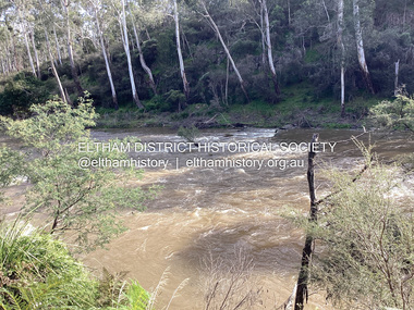 Eltham District Historical Society Inc
Photograph, Fay Bridge, Ancient Eel trap on the Yarra River at Laughing Waters, Eltham - pre-dating European settlement, 6 September 2023
... River near the former Morrison property Killeavey was given a language name in 2015 at the instigation of Wurundjeri Elder, Dave Wandin. Garambi Baan means “laughing waters” in the traditional language, Woi wurrung. The site at Warrandyte was rediscovered by Campbell Beardsell OAM in 2007 and is one of only a few known remaining iuk (eel) traps on Country once found the length of the Birrarung (Yarra) and the Maribyrnong. Original Indigenous aquacultural infrastructure was dismantled, taken away from sites and used to build houses, fords...River near the former Morrison property Killeavey was given a language name in 2015 at the instigation of Wurundjeri Elder, Dave Wandin. Garambi Baan means “laughing waters” in the traditional language, Woi wurrung. The site at Warrandyte was rediscovered by Campbell Beardsell OAM in 2007 and is one of only a few known remaining iuk (eel) traps on Country once found the length of the Birrarung (Yarra) and the Maribyrnong. Original Indigenous aquacultural infrastructure was dismantled, taken away from sites and used to build houses, fords ...Laughing Waters is the name for a stretch of the Yarra Valley Parklands consisting of river flats and hilly riparian bushland. With Birrarung (Yarra River) flowing through, Laughing Waters has been an important gathering place for thousands of years. For the Wurundjeri, ‘Garambi Baan’ (the name for Laughing Waters in Woi wurrung) is an important site for growing and harvesting food. Significantly, Wurundjeri iuk (eel) traps remain at Garambi Baan to this day. The Wurundjeri Woi Wurrung People take their name from the Woi wurrung language word ‘wurun’ meaning the Manna Gum (Eucalyptus viminalis) which is common along ‘Birrarung’ (Yarra River), and ‘djeri’, the grub which is found in or near the tree. Wurundjeri are the ‘Manna Gum People’ and their Ancestors have lived on this land for millennia. The site on the Yarra River near the former Morrison property Killeavey was given a language name in 2015 at the instigation of Wurundjeri Elder, Dave Wandin. Garambi Baan means “laughing waters” in the traditional language, Woi wurrung. The site at Warrandyte was rediscovered by Campbell Beardsell OAM in 2007 and is one of only a few known remaining iuk (eel) traps on Country once found the length of the Birrarung (Yarra) and the Maribyrnong. Original Indigenous aquacultural infrastructure was dismantled, taken away from sites and used to build houses, fords and roads by Europeans. The difficult and restricted access to this site is thought to be one of the reasons for its survival. The iuk trap is located within lands managed by Parks Victoria. The Narrap team in partnership with Parks Victoria and Acacia Land Management have been improving the native vegetation with a program of woody weed removal, exclusion fencing and revegetation. Importantly, the team have restored the trap’s infrastructure and have demonstrated its effectiveness.” References: Wurundjeri Woi Wurrung Cultural Heritage Aboriginal Corporation - Laughing Waters. (2023, September 3). Retrieved from https://inplace.org.au/laughing-waters/ GARAMBI BAAN LAUGHING WATERS RESIDENCY CENTRE 2020 2024 Strategic Plan, Nillumbik Shire Council (2023, September 3). Retrieved from https://www.nillumbik.vic.gov.au/files/assets/public/minutes-and-agendas/2020/09-sep/15-sep-cm/ocm.177-20-attachment-1-laughing-waters-arts-program_1.pdffay bridge collection, eel trap, laughing waters, yarra river, wurundjeri woi wurrung, garambi baan, 2023-09-06 -
 Eltham District Historical Society Inc
Photograph - Digital Photograph, Alan King, Downing-Le Gallienne house, Yarra Braes Road, Eltham, 30 January 2008
... Ford set the boulder steps and made a pool as part of the landscaping he completed. Inside, the mud-bricks are largely whitewashed with pine-lined ceilings and Oregon beams. A winding timber staircase in the front extends behind a glass window from the ground floor to the top. The property, of a little more than 0.5 ha, is bordered by Parks Victoria land, which extends to the Yarra River...Ford set the boulder steps and made a pool as part of the landscaping he completed. Inside, the mud-bricks are largely whitewashed with pine-lined ceilings and Oregon beams. A winding timber staircase in the front extends behind a glass window from the ground floor to the top. The property, of a little more than 0.5 ha, is bordered by Parks Victoria land, which extends to the Yarra River ...The property is a classic example of what made Eltham famous from the late 1940s to the 1960s. Covered under Heritage Overlay, Nillumbik Planning Scheme. Published: Nillumbik Now and Then / Marguerite Marshall 2008; photographs Alan King with Marguerite Marshall.; p149 The first view of the large double-storey house at Yarra Braes Road, Eltham South, is of a jutting roofline over a balcony, reminiscent of a large sailing vessel or galleon – very appropriate, considering the name of one of the first owners, Le Gallienne. The Downing-Le Gallienne property is a classic example of what made Eltham famous from the late 1940s to the 1960s and attracted so many artists and intellectuals to the area. Set in a largely indigenous bush-style garden, the mud-brick and timber house was built by Alistair Knox. It was built for economist Richard Downing, to become a founder of the welfare state in Australia and Chairman of the Australian Broadcasting Commission, and musician and composer Dorian Le Gallienne. Le Gallienne was a pioneering composer of modern music in Victoria before 1945, whose works included the Symphony in E.1 He wrote several pieces of film music for Eltham Films, including The Prize, working with its writer and artistic director Tim Burstall. Le Gallienne was also a music critic for The Argus and later for The Age. In 1967 the music critic Roger Covell argued that Le Gallienne’s Symphony, was ‘still the most accomplished and purposive . . . written by an Australian’. According to Alan Marshall the main inspiration behind the building that evolved from 1948 to 1964 was Le Gallienne. ‘He was able to see value in the simplest things and many who worked there had their eyes opened for the first time to the Eltham environment, to the bush and the trees and the fauna which lived there.’ The garden included no formality, no lawns, nor exotic plants. ‘Natural informal growth came right up to their doors and so did the indigenous birdlife.’ This informal style – consisting of mass and void – was to be developed and popularised by landscaper Gordon Ford from the 1950s. The large mud-brick and timber house, which was built in four stages and has three separate but linked sections, began as a small weekend retreat for the couple. In 1948, Downing and Le Gallienne (Dick and Dor to their friends), asked Knox to build the 36 x18 foot (11mx5.4m) building with a pitched slate roof. It was built on a concrete slab and included a fireplace, which is still in use. The second wing was built in 1954 after Downing had returned from working at the International Labour Office and the couple decided to live there full-time. The third section was built after the death of Le Gallienne in 1963, aged 48. He is buried in the Eltham Cemetery. When Downing married widow, Jean Norman (nee McGregor) and had to accommodate a large family, including her six children and one of their own, the last stage was built by 1964. At that time the house was considered one of the largest mud-brick houses in Victoria. It consists of five living areas, including a small ballroom. Several artists helped Knox build the Downing-Le Gallienne house, which was one of his first of mud-brick. They included painter Clifton Pugh, artist John Howley and actor Wynn Roberts. Ellis Stones had landscaped the first wing and Gordon Ford set the boulder steps and made a pool as part of the landscaping he completed. Inside, the mud-bricks are largely whitewashed with pine-lined ceilings and Oregon beams. A winding timber staircase in the front extends behind a glass window from the ground floor to the top. The property, of a little more than 0.5 ha, is bordered by Parks Victoria land, which extends to the Yarra River.This collection of almost 130 photos about places and people within the Shire of Nillumbik, an urban and rural municipality in Melbourne's north, contributes to an understanding of the history of the Shire. Published in 2008 immediately prior to the Black Saturday bushfires of February 7, 2009, it documents sites that were impacted, and in some cases destroyed by the fires. It includes photographs taken especially for the publication, creating a unique time capsule representing the Shire in the early 21st century. It remains the most recent comprehenesive publication devoted to the Shire's history connecting local residents to the past. nillumbik now and then (marshall-king) collection, dorian le gallienne, downing-le gallienne house, eltham, mudbrick construction, mudbrick houses, richard downing, yarra braes road -
 Eltham District Historical Society Inc
Photograph - Digital Photograph, Jim Connor, River Bend House, 130 Laughing Waters Road, Eltham, 7 September 2013
... Ford, Boomerang House. An unexpected afternoon tea was offered to us by the artists in residence at Birrarung House and we had a brief opportunity to view inside the house. River...Ford, Boomerang House. An unexpected afternoon tea was offered to us by the artists in residence at Birrarung House and we had a brief opportunity to view inside the house. River ...Laughing Waters Walk, 7 Sep 2013 This Society excursion was a follow up to the Laughing Waters Story told to us by Jane Woollard at our Annual General Meeting in March 2013. It involved a walk commencing from the corner of Laughing Waters and Overbank Roads along Laughing Waters Road to its eastern end and returning partly over the same route - a total distance of about 2.5km. On the way we visited the two artist in residence properties, River Bend and Birrarung, to view the houses on them that are associated with Alistair Knox, Gordon Ford and others in the local mud brick and artistic community. We also able to walk around the derelict ruin which was once home to Gordon and Sue Ford, Boomerang House. An unexpected afternoon tea was offered to us by the artists in residence at Birrarung House and we had a brief opportunity to view inside the house. River Bend was designed and built by Alistair Knox for Rosemary and Bill Cuming in 1968. It sits in a deep cutting on a steep slope above the Yarra River and features floor to ceiling windows and glass doors set into mission brown timber frames and walls of reclaimed bricks in pinkish hue. Rosemary laid the brick paving around the house, a copy of the shell paving found in the ancient French town of Colmar, where the family had lived for a period. The kitchen was equipped with a 1960s stove as well as a cast iron wood stove reclaimed from Rosemary's sister's home in Armadale. Max and Tini Huygens, migrants from Holland, purchased the property in 1975 and named it Tilwinda from an Aboriginal word meaning 'hole in a rock'. In late 1981 Tini died after a short illness, but Max continued to live at Tilwinda until he moved to a retirement village in 2000 and the property was sold to Parks Victoria. Renamed River Bend, the property became part of the Laughing Waters Artist in Residency Program in 2008. Nillumbik Shire Council upgraded the property in 2012 with solar panels, a heat pump for hot water and double glazing to improve the comfort of the artists in residence and make the house more energy efficient. For a more in-depth description of the property and biographies of the various artists in residence commencing from 2008 to 2015, see Jane Woollard's book, "Laughing Waters Road; Art, Landscape & Memory in Eltham" published 2016.2013-09-07, activities, artists in residence, eltham district historical society, heritage excursion, jim connor collection, laughing waters road, river bend house -
 Eltham District Historical Society Inc
Photograph - Digital Photograph, Jim Connor, Birrarung House, 195 Laughing Waters Road, Eltham, 7 September 2013
... On the way we visited the two artist in residence properties, River Bend and Birrarung, to view the houses on them that are associated with Alistair Knox, Gordon Ford and others in the local mud brick and artistic community. ...On the way we visited the two artist in residence properties, River Bend and Birrarung, to view the houses on them that are associated with Alistair Knox, Gordon Ford and others in the local mud brick and artistic community. ...Laughing Waters Walk, 7 Sep 2013 This Society excursion was a follow up to the Laughing Waters Story told to us by Jane Woollard at our Annual General Meeting in March 2013. It involved a walk commencing from the corner of Laughing Waters and Overbank Roads along Laughing Waters Road to its eastern end and returning partly over the same route - a total distance of about 2.5km. On the way we visited the two artist in residence properties, River Bend and Birrarung, to view the houses on them that are associated with Alistair Knox, Gordon Ford and others in the local mud brick and artistic community. We also able to walk around the derelict ruin which was once home to Gordon and Sue Ford, Boomerang House. An unexpected afternoon tea was offered to us by the artists in residence at Birrarung House and we had a brief opportunity to view inside the house. Birrarung is situated near the end of Laughing Waters Road. It was built in 1974 by Graeme Rose for Gordon Ford who he had asked to build him a small ‘bach’. Builder Peter Jarvis who did his apprenticeship with Alistair Knox for a couple of years recalled there were no drawings. It evolved as more funds became available. Graeme would source second-hand building materials around which he would shape the house. The fireplace was built with chicken wire over which it was rendered with faro cement. A brick floored glass studio, added later, faces a wall of boulders pressed into a manmade cliff, a large pond the link between the rock wall and glass studio. A waterfall, fed by river water, no longer functions. The property became part of the Laughing Waters Artist in Residency Program with the first artist taking up residency in 2001. For a more in-depth description of the property and biographies of the various artists in residence commencing from 2001 through to 2015, see Jane Woollard's book, "Laughing Waters Road; Art, Landscape & Memory in Eltham" published 2016.2013-09-07, activities, artists in residence, eltham district historical society, heritage excursion, jim connor collection, laughing waters road, birrarung house -
 Eltham District Historical Society Inc
Photograph - Digital Photograph, Jim Connor, Boomerang House, 195 Laughing Waters Road, Eltham, 7 September 2013
... Ford and photographer Sue Winslow were married in 1965. They set up home in an old log cabin on the property Gordon had purchased in 1954 on Laughing Waters Road. Situated between the Yarra River...Ford and photographer Sue Winslow were married in 1965. They set up home in an old log cabin on the property Gordon had purchased in 1954 on Laughing Waters Road. Situated between the Yarra River ...Laughing Waters Walk, 7 Sep 2013 This Society excursion was a follow up to the Laughing Waters Story told to us by Jane Woollard at our Annual General Meeting in March 2013. It involved a walk commencing from the corner of Laughing Waters and Overbank Roads along Laughing Waters Road to its eastern end and returning partly over the same route - a total distance of about 2.5km. On the way we visited the two artist in residence properties, River Bend and Birrarung, to view the houses on them that are associated with Alistair Knox, Gordon Ford and others in the local mud brick and artistic community. We also able to walk around the derelict ruin which was once home to Gordon and Sue Ford, Boomerang House. An unexpected afternoon tea was offered to us by the artists in residence at Birrarung House and we had a brief opportunity to view inside the house. Gordon Ford and photographer Sue Winslow were married in 1965. They set up home in an old log cabin on the property Gordon had purchased in 1954 on Laughing Waters Road. Situated between the Yarra River and Overbank Road, Gordon had built a small mud-brick shack on the river and a pontoon. Over the decades the shack has been locally referred to as “the love shack”, the “rooting shack” or simply “Gordon’s shack”. Gordon and Sue commissioned local builder Graeme Rose to do a wattle and daub renovation and extension to the old log cabin on the north side of Laughing Waters Road. The work had only just been completed in 1965 when a bushfire swept through the area and destroyed the cabin. Gordon and Sue relocated to his property, Fulling, in Pitt Street, Eltham. In 1970 work started on a new house at the Laughing Waters property. Originally known as the Banana House, it is now known as Boomerang. Designed by Alistair Knox, the mud-brick house includes iron window grilles made by Matcham Skipper that puncture the curved mud walls. The grilles were made from ‘off-pressings’ from the Sidchrome tool works in Heidelberg. Gordon, Sue and family moved into the house in 1972. Their marriage fell apart and Sue moved to Sydney with the children around the same time Gordon commenced building Birrarung just below Boomerang on the Laughing Waters Road block. After the Fords moved out, Boomerang it was rented out to various share households of students, musicians, artists and environmentalists for twenty-four years. Gordon Ford sold Birrarung and Boomerang to Melbourne Water in 1999. The Laughing Waters Artist in Residence Program was developed as a partnership between Parks Victoria and Nillumbik Shire Council. Boomerang was deemed unfit for habitation so was used as a day studio only. By 2001 Boomerang was in a poor state of repair and by 2002 the last artist in residence was to use the house as a studio. Nillumbik Shire Council had been granted funds from the Melbourne Community Fund to restore both Boomerang and Birrarung but it was apparent in early 2003 that the funds would be insufficient to restore both houses. Boomerang was infested with termites which presented a risk to any occupants and so the decision was made to close Boomerang and concentrate funding on Birrarung. Boomerang was fenced off for safety and to prevent intrusion and remains ‘caged’ today (2023). However, it is readily apparent the property has been occupied by squatters over the years. By 2023 it was clear that the squatters had abandoned the property and sections of the roof structure have given away in some areas and collapsed internally. For a more in-depth description and history of the property and that of Gordon and Sue Ford, see Jane Woollard's book, "Laughing Waters Road; Art, Landscape & Memory in Eltham" published 2016.2013-09-07, activities, eltham district historical society, heritage excursion, jim connor collection, laughing waters road, boomerang house, gordon ford -
 Eltham District Historical Society Inc
Photograph - Digital Photograph, Jim Connor, Fireplace, Boomerang House, 195 Laughing Waters Road, Eltham, 31 August 2021
... Ford and photographer Sue Winslow were married in 1965. They set up home in an old log cabin on the property Gordon had purchased in 1954 on Laughing Waters Road. Situated between the Yarra River...Ford and photographer Sue Winslow were married in 1965. They set up home in an old log cabin on the property Gordon had purchased in 1954 on Laughing Waters Road. Situated between the Yarra River ...Gordon Ford and photographer Sue Winslow were married in 1965. They set up home in an old log cabin on the property Gordon had purchased in 1954 on Laughing Waters Road. Situated between the Yarra River and Overbank Road, Gordon had built a small mud-brick shack on the river and a pontoon. Over the decades the shack has been locally referred to as “the love shack”, the “rooting shack” or simply “Gordon’s shack”. Gordon and Sue commissioned local builder Graeme Rose to do a wattle and daub renovation and extension to the old log cabin on the north side of Laughing Waters Road. The work had only just been completed in 1965 when a bushfire swept through the area and destroyed the cabin. Gordon and Sue relocated to his property, Fulling, in Pitt Street, Eltham. In 1970 work started on a new house at the Laughing Waters property. Originally known as the Banana House, it is now known as Boomerang. Designed by Alistair Knox, the mud-brick house includes iron window grilles made by Matcham Skipper that puncture the curved mud walls. The grilles were made from ‘off-pressings’ from the Sidchrome tool works in Heidelberg. Gordon, Sue and family moved into the house in 1972. Their marriage fell apart and Sue moved to Sydney with the children around the same time Gordon commenced building Birrarung just below Boomerang on the Laughing Waters Road block. After the Fords moved out, Boomerang it was rented out to various share households of students, musicians, artists and environmentalists for twenty-four years. Gordon Ford sold Birrarung and Boomerang to Melbourne Water in 1999. The Laughing Waters Artist in Residence Program was developed as a partnership between Parks Victoria and Nillumbik Shire Council. Boomerang was deemed unfit for habitation so was used as a day studio only. By 2001 Boomerang was in a poor state of repair and by 2002 the last artist in residence was to use the house as a studio. Nillumbik Shire Council had been granted funds from the Melbourne Community Fund to restore both Boomerang and Birrarung but it was apparent in early 2003 that the funds would be insufficient to restore both houses. Boomerang was infested with termites which presented a risk to any occupants and so the decision was made to close Boomerang and concentrate funding on Birrarung. Boomerang was fenced off for safety and to prevent intrusion and remains ‘caged’ today (2023). However, it is readily apparent the property has been occupied by squatters over the years. By 2023 it was clear that the squatters had abandoned the property and sections of the roof structure have given away in some areas and collapsed internally. For a more in-depth description and history of the property and that of Gordon and Sue Ford, see Jane Woollard's book, "Laughing Waters Road; Art, Landscape & Memory in Eltham" published 2016.jim connor collection, laughing waters road, boomerang house, gordon ford