Showing 136 items matching "forest creek victoria"
-
 Tatura Irrigation & Wartime Camps Museum
Book, The Pennyweight Kids, 1988
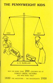
... Forest Creek Victoria...Written to try to discover why more than 200 children died at Forest Creek, Victoria. Stories of their families....Tatura Irrigation & Wartime Camps Museum 49 Hogan Street Tatura the-murray Written to try to discover why more than 200 children died at Forest Creek, Victoria. Stories of their families. Forest Creek Victoria Deaths at Forest Creek Victoria Yellow cover, sketch of scales 1852-1857. ...Written to try to discover why more than 200 children died at Forest Creek, Victoria. Stories of their families.Yellow cover, sketch of scales 1852-1857. Gold mining scene and grieving mother. On back cover sketch of excavation of old burial site. London 1852. Gentleman's Magazine.forest creek victoria, deaths at forest creek victoria -
Clunes Museum
Book, CASTLEMAINE MAIL, THE PENNYWEIGHT KIDS 1852 - 1857, 1988
... ...FOREST CREEK VICTORIA AUSTRALIA...Clunes Museum 36 Fraser Street enter building through Collins Place Clunes goldfields local history book FOREST CREEK VICTORIA AUSTRALIA CHILDREN ON THE GOLDDFIELDS SMALL VOLUME RELATING TO DEATH OF CHILDREN ON THE GOLDFIELDS AT FOREST CREEK, VICTORIA, 1852-1857 HANDWRITTEN IN BLUE BIRO : CLUMES MUSEUM FROM THE AUTHOR, 95 ROWAN WRITTEN IN BLUE BIRO - ENQ. 742522 YELLOW COVER WITH IMAGES DRAWN IN BLACK INK BY THE AUTHOR, OF A SET OF GOLD SCALES, A MAN WASHING GRAVEL THROUGH A CRADLE FOR GOLD AND A WOMENT LOOKING OVER A CHILD'S CRADLE THE PENNYWEIGHT KIDS 1852 - 1857 Book BOOK CASTLEMAINE MAIL A R MCMILLAN ...SMALL VOLUME RELATING TO DEATH OF CHILDREN ON THE GOLDFIELDS AT FOREST CREEK, VICTORIA, 1852-1857YELLOW COVER WITH IMAGES DRAWN IN BLACK INK BY THE AUTHOR, OF A SET OF GOLD SCALES, A MAN WASHING GRAVEL THROUGH A CRADLE FOR GOLD AND A WOMENT LOOKING OVER A CHILD'S CRADLEnon-fictionSMALL VOLUME RELATING TO DEATH OF CHILDREN ON THE GOLDFIELDS AT FOREST CREEK, VICTORIA, 1852-1857local history, book, forest creek victoria australia, children on the golddfields -
 Bendigo Historical Society Inc.
Book - STRAUCH COLLECTION: THE PENNYWEIGHT KIDS
... The Pennyweight Kids 1852 1857, why did more than 200 children die at Forest Creek, Victoria and who were they ? 1830 The Ancestors - The Descendants 1930, soft cover 116 pages with black and white photographs & illustrations....History House 11 Mackenzie Street Bendigo goldfields PLACE Cemetery castlemaine History-Victoria-Castlemaine-Children-Cemetery A R McMillan The Pennyweight Kids 1852 1857, why did more than 200 children die at Forest Creek, Victoria and who were they ? 1830 The Ancestors - The Descendants 1930, soft cover 116 pages with black and white photographs & illustrations. ...The Pennyweight Kids 1852 1857, why did more than 200 children die at Forest Creek, Victoria and who were they ? 1830 The Ancestors - The Descendants 1930, soft cover 116 pages with black and white photographs & illustrations.A R McMillanplace, cemetery, castlemaine, history-victoria-castlemaine-children-cemetery -
 Bendigo Historical Society Inc.
Photograph - FOREST CREEK GOLD MINES CRUSHING BATTERY AT CHEWTON, c.1890
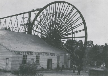
... Black and white photograph. Forest Creek (Victoria) gold reefs crushing works. The Garfield overshot waterwheel which drove the battery at Chewton. ...History House 11 Mackenzie Street Bendigo goldfields BUILDINGS Commercial garfield waterwheel at chewton Bendigo Advertiser Black and white photograph. Forest Creek (Victoria) gold reefs crushing works. The Garfield overshot waterwheel which drove the battery at Chewton. ...Black and white photograph. Forest Creek (Victoria) gold reefs crushing works. The Garfield overshot waterwheel which drove the battery at Chewton. Inscriptions on back: 'MNG 31''Garfield Mine, Chewton, J Ebbett, Manager' ( in top LHC), 'Royal Historical Society of Victoria, Bendigo Branch' (in circular rubber stamp). History of object: Previous ACC. No. 'MNG 31', Ralph Birrell 5.11.1999 'Garfield Waterwheel and Crushing Mill, Chewton:' Gardield overshot waterwheel which drove the Forest Creek Gold Mines crushing battery at Chewton. The foundations of this wheel can still be seen today.Bendigo Advertiserbuildings, commercial, garfield waterwheel at chewton -
 Kiewa Valley Historical Society
Photo: Memorial on the Staircase Spur Track, Mt Bogong
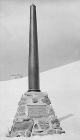
... Victoria. The Staircase Spur track to its top starts at Mountain Creek Road going through forest and continuing above the snow line to grass land. ...Victoria. The Staircase Spur track to its top starts at Mountain Creek Road going through forest and continuing above the snow line to grass land. ...Mt Bogong is the highest mountain in Victoria. The Staircase Spur track to its top starts at Mountain Creek Road going through forest and continuing above the snow line to grass land. The weather can change very quickly with cloud and snow making conditions dangerous. Large sepia photo of the Memorial in snow on the Staircase Spur Track on Mt Bogong. The Memorial has a plaque attached: Sacred to the Memory / of Georgine Gadsden / Edward Neave Welch / John McRae / who perished here during a blizzard / about August 2nd 1943staircase spur memorial, mt bogong -
 Kiewa Valley Historical Society
Book - Non Fiction History, The Kiewa Story, circa 1993
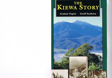
... forests and high plains can viewed as an example (compared to the Tasmanian Hydro schemes) of how future hydro schemes (an inevitable requirement) will proceed. Most rural towns (in the early 1900s) were built by unencumbered rural based citizens, with the exception of Mount Beauty and Falls Creek. These two settlements were brought into life by a State (Victorian) Authority for a specific function and program. They were a gated community, that is, only open to construction workers involved with the hydro scheme. All facilities within these communities were provided by the State Electricity Commission of Victoria ...This book provides in chronological order the development of the Kiewa Hydro-electricity scheme from the first concept (1911) to final construction work (1961). It covers the first attempt to utilise the power of the Victorian Alps water system. It started from a private syndicate and developed to the current State Electricity Commission of Victoria. The incentive for the Hydro scheme was to make money and not as an alternative to the carbon producing coal fired power plants. These coal fired power plants were increasing in numbers to service an ever increasing demand made by population expansion, especially in cities and large rural settlements. This demand spiraled up after World War II when there was a tremendous spike in immigration numbers due to refugees and displaced persons in Europe. The ability to utilise the untapped water provided by the winter snow fields, for a higher yield in electricity, was a powerful incentive to overcome the physical hardships in this remote Alpine region. Future power requirements may initiate the re-installation of the other two power stations(Pretty Valley and Big Hill) covered in original Scheme. This publication not only covers the development of the Kiewa Valley region with respect to population (within a socio-economical framework) but also the subtle but yet strong physical changes of a relatively pristine alpine region. The demands that an ever growing regional population places on the environment is clearly documented in print and black and white photographs. The working and living conditions of those who constructed and gave life to this hydro scheme is well documented in this book. It may be viewed as spartan now but was relevantly good at that moment in time, especially for those workers fleeing a devastated European environment. The successful planning and consideration to minimising any intrusion upon the natural alpine forests and high plains can viewed as an example (compared to the Tasmanian Hydro schemes) of how future hydro schemes (an inevitable requirement) will proceed. Most rural towns (in the early 1900s) were built by unencumbered rural based citizens, with the exception of Mount Beauty and Falls Creek. These two settlements were brought into life by a State (Victorian) Authority for a specific function and program. They were a gated community, that is, only open to construction workers involved with the hydro scheme. All facilities within these communities were provided by the State Electricity Commission of Victoria. The impact on the social, financial and individual independency of the community, by the transition from the S.E.C .environment to one of local government (Shire of Bright), had in some cases a severe impact.This hard covered book has a green cover with pictures on the front and back covers. The front cover has a coloured picture of a snow covered Mount Bogong taken from the opposite mountain range. The valley between both ranges has a whisk of mist over it. At the bottom of this picture are three black and white photographs covering the construction of the Kiewa Hydro - Electricity Scheme. On the back cover is a photograph, (black and white) detailing the Bogong village and Junction dam containing lake Guy. The inside front cover is a black and white photograph which details the construction of the West Kiewa tailrace tunnel during April 1951. The inside back cover is a black and white photograph of the concrete pour at the Clover Dam circa 1952. All photographs and sketches are in black and white. The pages are approximately 160 g/m2 and those which have photographs are on gloss paper.Book spine: "The Kiewa Story Graham Napier Geoff Easdown" alongside this is a white framed circle with white spokes radiating out and underneath in white lettering SECkiewa valley, hydro scheme, victorian alpine region, electricity generators, graham napier, geoff easdown -
 Emerald Museum & Nobelius Heritage Park
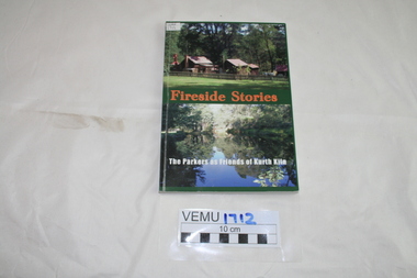
Book, Friends of Kirth Kiln, Fireside Stories, The Parkers as Friends of Kurth Kiln, February 2010
... victoria gembrook Charcoal burner Fireside Stories with Genseric (Bill) Parker and Lorna Parker. Reflections collected by Friends of Kirth Kiln. Green soft cover booklet of 128 pages. The front cover has 2 photos; the top one of the caretakers compound with Forest Commission huts and the bottom photo is of the Lake, taken from the dam on Tomahawk Creek. ...Kith Kiln was the site of a short lived charcoal kiln designed to provide an alternative to petrol during World War 11 when there was a fuel shortage. Local history has been told by Genseric (Bill) Parker and the reflections collected by Friends of Kirth Kiln (under the auspices of Parks Victoria).The booklet is significant because it tells the story of the development of the Kirth Kiln Park in Gembrook, from the Friends perspective.The park is not only historical but is also of great environmental significance and it forms part of community life in the district. Green soft cover booklet of 128 pages. The front cover has 2 photos; the top one of the caretakers compound with Forest Commission huts and the bottom photo is of the Lake, taken from the dam on Tomahawk Creek. The back cover has a diagram of the Kiln logo.Fireside Stories with Genseric (Bill) Parker and Lorna Parker. Reflections collected by Friends of Kirth Kiln.kirth kiln, genseric parker, parks victoria, gembrook, charcoal burner -
Federation University Historical Collection
Document, Zelda Martin, Central Victorian Goldmining towns - Boom Towns or Ghost Towns?, c1996
... Creek...Police court...Carisbrook...dunolly...thompson's foundry...Charles Clacy...Anthony Trollope...Robert Cecil...Mount Alexander...urbanisation...national schools...education...govenrment...industry...railway...transport...settlement...land settlement in central Victoria...Steiglitz...Joseph Brady...The New Australian Mine...Berry Deep Leads...William Guthrie Spence...Creswick State Forest...Victoria,1854. Addresses on behalf of : the people of Bendigo; Members of the Church of England, Bendigo; Members of the Wesleyan Church on the Bendigo Gold Fields; Bendigo Gold District General Hospital; the Bendigo Prospecting Association; Committee of the Bendigo Local Exhibition; Bendigo District Medical Association; Coloured Americans Resident at Bendigo; German Inhabitants of Bendigo; Landowners, Inhabitants, and Miners of Castlemaine; Inhabitants of Forest Creek; Inhabitants of Heathcote and Gold Miners of McIvor; Residents and landholders of the District of Bacchus Marsh; Inhabitants of Kilmore and Vicinity. ...Victoria,1854. Addresses on behalf of : the people of Bendigo; Members of the Church of England, Bendigo; Members of the Wesleyan Church on the Bendigo Gold Fields; Bendigo Gold District General Hospital; the Bendigo Prospecting Association; Committee of the Bendigo Local Exhibition; Bendigo District Medical Association; Coloured Americans Resident at Bendigo; German Inhabitants of Bendigo; Landowners, Inhabitants, and Miners of Castlemaine; Inhabitants of Forest Creek; Inhabitants of Heathcote and Gold Miners of McIvor; Residents and landholders of the District of Bacchus Marsh; Inhabitants of Kilmore and Vicinity. ...Zelda Martin was a PhD candidate at the University of Melbourne.[.1] 4th item in light blue display book titled Research Approach/Overview of Chapters/Confirmation of Canditure/Chapters1,2,3&4 of proposed thesis. *Twenty-seven page article on Victorian goldfields towns titled: Central Victorian Goldmining Towns - Boom Towns or Ghost Towns. The article was written during the author's PhD study. It outlines the context methodology, and resources and the chapters of the proposed thesis: (1) Central Victorian Goldmining Towns - The Context (2) Contemporary Views of the Factors Necessary for Town Growth (3) Outward Manifestations of Town Growth (4) The Trappings of Government (5-9) The Main Towns and Their Hinterland. [.2] 5th item in Light Blue display book as above item. *Chapter 1 of proposed thesis titled 'Pick, Shovel and Tin Dish Mining.' Covers in Section A: Central Victoria - Pre 1851: Aborigines in Central Victoria, Squatters, and Government. Section B: The years 1851-1854: The Early Gold Rushes, Government Reaction, Township Surveys, Legislation, Town Development, Local Government and Early Settlement. [.3] 6th item in Light Blue display book as above item. *2A of proposed thesis titled 'Contemporary Views of the Factors Necessary for Town Growth'. Similar information to Chapter 1 plus extra re towns and maps. Sections: Introduction, Context of Place - Geographical Towns Listed, The Context of Time - Pre1851 Aborigines, Governance of Port Phillip, The Squatters, The Villages of Central Victorian Highlands, Conclusion, Condensed Version of Chapter2B. [.4] 7th item in Light Blue display book as above item. *Chapter2B of proposed thesis. Sections: Area of Research, Schools, Banks, Newspapers, Progress Association, Town Development - Sandhurst (Bendigo), Ballarat, Castlemaine,, Maryborough, Ararat and Stawell. [.5] 8th item in Light Blue display book as above item. *Chapter 3 of proposed thesis titled 'Outward Manifestations of Town Growth'. Sections: Introduction, Contemporary Writing, Educationalists, The Bankers, The Townsfolk, Current Theory, General Theories of Urban Development, and Conclusion. [.6] 9th item in Light Blue display book as above item. *Chapter 4 of proposed thesis titled 'Trappings of Government' Sections: Introduction, Early Government Attitudes to Mining and Town Development, Law and Order, Township Surveys, Legislation, Local Government, Transport and Communication, The People and Lobbyists. [.7] 10th item in Light Blue display book as above item. *'The Rise and Fall of Central Victorian Goldmining Towns'. Includes a map showing main Goldfields, a table showing towns and villages at two points in time - 1857 and 1871; a Bibliography of Primary and Secondary Sources. [.8] Resource No1. Black display book titled Local Towns 1 : Alma: *Brief history *Directory *Maps Amphitheatre / Mountain Hut: *Brief History Post Office Directory Ararat: *Brief History *Post Office Directory 1869 - Alphabetical Listing by Occupation *Ararat - Prominent Citizens of 1858 *Langi-Morgala Museum Avoca: *Brief History *Excerpts from 'Avoca The Early Years', Margery and Betty Beavis; pg1 - Beginnings; pg11 - The Midas Touch; pg25 - Local Gold Escorts; pg27 - A Town is Born; pg51- The Administration of Justice; pg53 - The Ways of the Law; pg61 - News of the Day; pg65 - A Time to Play; pg72 - Land Ownership *Post Office Directory (Bailliere's) 1869 *Tourism Map and Information of area *Historic Avoca - A 5.5km Tour *Avoca & the Pyrenees Region - information pamphlet Ballarat: *Early History of Ballarat - Ballarat Historical Society, Publication No.1: origin of the name; Ballaarat - the Beginning; Fabulous Yields from the Ballaarat Goldfield; *Streetscape Lydiard Street. *Hand drawn map showing Leigh River, Old Portland Bay Road, plaque on road to Colac; etc. *Newspaper article re 'The Theatre Royal' ( which stood in the vicinity of the current Owen Williams store) - 'The News'15/04/1998 *Article - 'Ballarat's Mechanics' Institute Lives On' Ballarat Courier, 14/09/1985 *Article - Standing the Test of Time' The News 17/11/1993 re The Mechanics Institute & picture of the Reading Room *'Ballarat a Study of a City, Phyllis Reichl, pub. Nelson, 1968; no.3 place, time and people field studies series *Investigator Vol.33 No.2, 1998 Geelong Historical Society. Article on pg75 describes Ballarat in 1861 *Folded poster - 'Ballarat 100' a history of telegraph communication, pub. Telecom. Beaufort (Fiery Creek): *Brief history *Post Office Directory [.9] Resource No.2 Black Folder Titled Towns cont.No2 Bendigo (Sandhurst): *'Family & Local History at the Bendigo Library - 1851-2001 150 years of gold'. *Bendigo Government Camp in 1853 illustration; key to sketch and names of Government officers stationed there *Excerpts from 'Bendigo and Vicinity' Adolph Haman *The Bendigo Goldfield Registry - pgs 1-7 Introduction *Excerpt: 'Breaking the Grip' *Excerpt: The Most Go-Ahead Place *Excerpts from 'History of Bendigo' - anti license agitation; laying out of town; proposed railway; gold calls and dividends; the Sandhurst Municipality; journalism *Bibliography Blackwood: *Excerpts from 'Aspects of Early Blackwood - The Goldfield, the Landmarks, the Pioneers' Alan J Buckingham and Margaret F Hitchcock, JG Publishing,1980 Buninyong: *A Brief History *Investigator Vol1 No.2 Feb 1966 Geelong Historical Society. Pg3 - Article re gold escort route - Mt Alexander to Adelaide - (see a simple monument on the Western Highway a few miles out of Horsham. Pg 15 - Ballarat Excursion - re the finding of gold. *Three articles published by Buninyong and District Historical Society Inc: (Magpie Exploration; Finding Gold In The Green Hills; Magpie Exploration; Burnt Bridge to Cargarie to Mt Mercer) *Copies of newspaper articles/items *Buninyong Street Directory Carisbrook: *In the Beginning There Was Carisbrook *The History of the Carisbrook Racecourse Carngham / Snake Valley: *Brief History *Directory Castlemaine: *Directory 1865-1866 - Alphabetical and Street *Poster - Castlemaine A Contemporary Guide "The Great Centre" 1866 - A Contemporary Guide to the Fascinating Past *Pamphlet - Castlemaine District Community Hospital *Map - Castlemaine, Maldon & Surrounding Districts *Map and Information - The Dry Diggings Track - a 55kl walk among historic goldfields relics ( Castlemaine Fryerstown Vaughan Mt Franklin Hepburn Daylesford) *Postcard - Former Court House *Directory 1867 - Alphabetical, Trade [.10] Resource No.3 Grey folder Titled Towns 3 Creswick to Maryborough Creswick: *Brief History *Booklet - "Creswick Cemetery Walk" *Booklet - The Buried Rivers of Gold Heritage Trail Creswick *Creswick Historical Museum Information Sheet *Chronological History of Creswick *Alphabetical Directory of the Borough of Creswick *Creswick's Creek Directory 1856 *Historic Creswick Walking Tour *A Brief Account of the Schools of Creswick - Past and Present *100 Years of Railway Travel in Creswick *The Berry Deep Leads *The Spence Home at Jackass Gully in the Creswick State Forest ( William Guthrie Spence - Pioneer) *The New Australian Mine and the 1882 Disaster *Creswick District News, Issue 7, July August 1999 *The Creswick Miners Walk - Information and Map *Maps Chewton: *Brief History *Directory Clunes: *Brief History *Clunes Street Directory Daylesford: *Brief History *Notable Bushfires in Daylesford District Over More Than a Century - "Black Thursday" 1851; 1862; 1899; the Disastrous Hepburn Fire of 1906; 1939; 1944; 1969. *Post Office Directory -Daylesford and Hepburn Dunolly / Inkerman: *Brief History *Directory *Pamphlet - Goldfields Historical Museum *Pamphlet - Historic Dunolly - Victoria's Best Kept Secret *Map of Gold Workings at Dunolly Area - showing where the main gold rushes occurred *Brief History - Inglewood *Directory - Inglewood - Name Occupation, Dwelling Kingower: *Brief History *Directory - Name / Ocupation / Dwelling Linton / Happy Valley / Piggoreet: *Brief History *Directory - Lintons McIvor: *"A History of the Shire and the Township of Heathcote" by J.O. Randell Majorca: *Brief History *Official Post Office Directory 1869 - Name / Occupation/ Address Maldon (Tarrangower): *Brief History Part 1 *Brief History Part 2 *Post Office Directory *List - Alphabetical Order by Names plus Business and Trade (Tarrangower Times Oct/1858) *List - Alphabetical Order by Trade plus Name and Business *Directory - Name / Occupation / Dwelling Maryborough: *Worsley Cottage - built by Arthur Worsley, a contractor in stonework in 1894 [.11] Resource No. 4 Blue Display Book titled Towns 4 Moliagul to Stawell Moliagul: *Brief History *Moligul Legislative Assembly (Voting?) List - Names and Occupations *Moliagul Victorian Post Office Directory 1868 - Name / Ocupation / Address / Comments *"The Welcome Stranger" gold nugget *The Sunday School *The Welcome Stranger Discovery Walk - information and map Moonambel (Mountain Creek) Redbank *Brief History *List of names extracted from advertisments of the Pioneer and Mountain Creek Advertiser 16/02/1861. *Bailliere's Directory 1869 - Alphabetical List of Name / Occupation / Place St Arnaud: *Brief History Sebastapol: *Brief History *Directory 1869 - Alphabetical by Name; plus occupation and address. Browns and Scarsdale: *Brief History *Browns Street Directory - Name and Occupation Smythesdale: *Brief Description *Smythesdale Street Directory -Name and Occupation Stawell (Pleasant Creek) *Brief History *Victorian Official Post Office Directory - Name /Occupation / Dwelling *Chronology - 1841-1920 *Production of gold statistics - 1879 - 1900 *Big Hill *Extracts from "The Golden Years of Stawell". Chapt 1 - Stawell's Coming Out. Capt. 2 - The Gold Rush. Caapt.3 - Cradle of Democracy. Chapt.4 - The Reefs Becomes Stawell. Chapt. 5 - Rushing In. Chapt.6 - The Pioneers. Chapt 7 - The Decade of Optimism. [.12] Resource No. 5: Blue Display Book titled 'Towns Steiglitz to the The Golden Triangle. Steiglitz: Brief History Victorian Post Office Directory 1869 *Map of Steiglitz *List of maps relevant to Steiglitz history *Information 6 tables of data from "Reports of Mining Surveyors Talbot (Back Creek) Brief History Taradale: Post office Directory 1869 - Name/Occupation/Street. Also list in alphabetical order by Occupation Taradale *Chronological Reference to Taradale Mines *Water - The Coliban System of Waterworks *Joseph Brady *The Syphon Tarnagulla (Sandy Creek) *Brief History *Tarnagulla Businessmen Cameos to give depth to advertisments in 'The Tarnagulla Courier' various issues 1864-1871 *Directory - Name/Occupation /Address *List - Name/Business/Trade Wedderburn (Koorong) *Brief History *List - Name/Occupation The Golden Triangle: *The Early Rushes - Wedderburn / Moliagul / Sandy Creek - Tarnagulla / Jones Creek - Waanyarra / Kingower / Dunolly - Goldsborough / Inglweood *Census of 1857 - Population / Occupations *1858-1871 - A Time of Consolidation- Wedderburn / Moliagul / Sandy Creek- Tarnagulla / Arnold *Census 1871 - Population *Information gleaned from the census data - Demographics / Population / Occupations / marital / Birthplace / Religion / Literacy/ Occupation and Housing Cameos *Graphs - Birthplace of settlers /Male-Female Ratio / Married males / Children under 15 as Percentage of Population / Religion *Census 1857 - Statistical data *Maps *Bibliography [.13] Resource No. 6 - Black Display Book Information and Research in Central Victoria including: *Banking - Research from ANZ Bank Archives *Institutions - also includes articles listed from the Ballarat Times Newspaper *Australian mining History Association - A.M.H.A. Bibliography *Australia's Mining History * Bibliography - Land Surveys Victoria - *1853 Administration (Statistics and Other) includes: schools / ministers of religion / police / military / local administration / licences for sale of spirits / distances between various Victorian gold fields. * Victoria Government Gazette (Copy) - N0. 116, 12/12/1854 includes: Gold Felds Commission of Enquiry & No. 85, 15/09/1854 - Addresses presented to the Lieutenant Governor (Sir Charles Hotham) during his tour through the Gold Fields of Victoria,1854. Addresses on behalf of : the people of Bendigo; Members of the Church of England, Bendigo; Members of the Wesleyan Church on the Bendigo Gold Fields; Bendigo Gold District General Hospital; the Bendigo Prospecting Association; Committee of the Bendigo Local Exhibition; Bendigo District Medical Association; Coloured Americans Resident at Bendigo; German Inhabitants of Bendigo; Landowners, Inhabitants, and Miners of Castlemaine; Inhabitants of Forest Creek; Inhabitants of Heathcote and Gold Miners of McIvor; Residents and landholders of the District of Bacchus Marsh; Inhabitants of Kilmore and Vicinity. *Gold Fields Correspondence 1853: letter from Lieutenant Colonel Valiant, (Officer commanding the Troops in Victoria) to the Lieutenant Governor re threatened disturbance at Sandhurst (Bendigo) regarding the Gold License Fee. * Extracts from a book "Victoria" re Gold Fields Commission of Enquiry involving mainly Ballarat and Castlemaine and a chapter titled 'A Tour to the Victorian Gold-Fields' *Lists of central Victorian newspapers - listed by date published 1851to 1874; by first date available to State Library. *A list of cities and towns showing County, population in 1861 &1871, and municipal status. [.14] Resource no.7. Black display book. *Reference: Papers presented to Parliament Victoria - 1859-1860 4 volumes - relevant sections copied. Contains information on Branches of Government. General / Finance / Gold / Gazette / Commission and Warrant / Statistic. *Gold Fields Act. In accordance with the Act the gold fields are divided into six districts - Ballaarat, Castlemaine , Sandhurst, Avoca, Ararat, and Beechworth.. Official staff in each gold district consists of a Resident Warden, Wardens, Wardens' Clerks, Bailiffs, Chinese Protectors, Chinese Interpreters, and Mining Surveyors. *Gold Receiver *Gaols *Police magistrates and Clerks of Petty Sessions, etc. *Field Branch *Immigration and Emigration Overland - Chinese - 1859 *Population on the Goldfields *The Geological Survey - The Government Geologist is assisited by staff from four branches - the office Branch; the Publishing Branch; the Field Branch and the Museum Branch. *Commission to Enquire Into Sludge dated 10/02/1859 (Some sections copied) - Report to the Honorable Chief Commissioner of Public Works, Melbourne re the mode of carrying the sludge from the puddling mills in Sandhurst without interfering with the drainage of the town and the roads in the neighbourhood. [.15] Resource No.8: Camel display book titled Resource No. 8. Aborigines *Lists of book titles - +"Readings in Victorian prehistory" +"The Aborigines of Port Phillip" +Aboriginal languages and clans" +"A History of the Port Phillip District" +"Langi Ghiran 1: Aboriginal Rock...." +"Koorie History: sources for aboriginal studies in the State Library of Victoria", ed. Tom Griffiths, Melb. Friends of the State Library, 1989 +"The Public Lands of Australia Felix"; settlement and land appraisal in Victoria1834-91 with special reference to the Western Plains", J.M.Powell, Melb. Oxford University Press 1970 +*Bibliography of the Victorian Aborigines' from the earliest manuscripts to 31st December 1970, Massoa, Aldo, Melb. Hawthorn Press, 1971 +"Aborigines in Colonial Victoria, 1836-1886", M.F. Christie, Sydney University Press, 1979 +"Urban and Industrial Australia: readings in Human Geography" ed J.M. Powell, Melb. Sorrett Pub. 1974 *Extracts: -Processes of Pioneer Settlement - The Squatting Occupation of Victoria, 1834-60. J.M. Powell -Areal Variations in the Class Structure of the Central-Place Hierarchy. P. Scott - Volume1 and Volume 2: Notes Relating to the Habits of the Natives of Other Parts of Australia and Tasmania. Compiled from various sources for the Government of Victoria by R Brough Smyth. John Curry, O'Neil, Melb. 1st pub. Melb. 1876. p31-45 - Numbers and Distribution of the Aborigines in Victoria -Victorian Aborigines 1835-1901 - A Resource Guide to the Holdings of the Public Record Office, Victoria; published by the Government Information Centre 1984. *History of the Aboriginal Artefacts Displayed in the Daylesford Museum. F. G. Powell (4 page pamphlet) *Letter to Zelda Martin from Peter Lovett, Cultural Officer, Ballarat & District Aboriginal Co- Operative, 05/02/1997 *Map: Ian Clarke Victorian Tribunal Boundary Map - Clans of Central Victoria. *Victorian Rock Art and Mythology - Article about Mount Langhi Ghiran and myths of the Tjapwarong people. *Two Aboriginal myths relating to the Grampians - 'The Monster Emu' / 'The Aquisition of Fire', by the Aborigines in the Grampians Areas *Article titled (chapter 8) Ballarat - information re camping sites in the region. Lake Wendouree / Lake Burrumbeet (includes a myth) / Mt Bunninyong / Lal Lal / Pitfield / Mount Elephant / Mount Egerton / Meredith / Lake Goldsmith / Lake Learmonth / Ercildoune *Notes on the Aborigines of the Wider Ballarat Region plus European names=Aboriginal names. John Morris 26/07/1995 *Role of Aborigines in Town Development in Central Victoria. Mentions Native Police Force est. in Port Phillip 1842 and Central Board for Aborigines est. 1860 *The Grave of King Billy. (Frank Wilson) Pamphlet. *Camping Places in Central and Northern Victoria. Article re Lake Burrumbeet site. *Programme for the Unveiling of Memorial Cairn for Edward Stone Parker 1802-1865. Note portrait not accurate. Accurate portrait is available in the book "A Successful Failure A Trilogy The Aborigines and Early Settlers", Edgar Morrison, Graffiti Publications, 2002. * Large envelope addressed to Mr G Netherway containing newspaper cuttings regarding the life of Edward Stone Parker, the unveiling of the Memorial Cairn as mentioned above, articles titled 'Episodes from Our Early Days' (Edgar Morrison, Yandoit)- The Black's School, A School At Last and The Final years. Also a typed page titled 'Historical Background to E.S.Parker's Career. Includes an interesting tale titled 'When the cat lay doggo' re laying power leads for the unveiling ceremony at the memorial site. [.16] green display folder titled 'Research Aids' *List of references to Commissioners' & W'ardens' Reports (formerly held at La Trobe Library Archives, now at Public Records Office [PRO]). Indicates town referred to / date of report / name of camp if different to town. * Archive information re Anglican Records *Movement around the Goldfields - Miners and Storekeepers - usefulness of newspapers in providing information - areas covered - Castlemaine, Maldon, Ararat, Stawell, Tarnagulla, Dunolly. *Port Phillip /Victoria Directories 1839/1867 - Chronological list of Directories included in this series. *"Notes on the History of Local Government in Victoria" A.W. Greig Melb. University Press 1925 - Photo-copied extract p5-p40. (Source - Deakin University Library) - Introduction by W.Harrison Moore. Section 1 - Development in New South Wales Before Separation. Section 2 - Development in Victoria After Its Separation from New South Wales. Hand written notations: 'roads, markets, and local government 1855 on' ;'opportunity of squatters in parliament' and 'opportunities of matters in parliament p33' * Notes on the Establishment of Surveyor General's Department 1851and Commissioner of Crown Lands and Survey. * Newspaper articles from The Argus, 1849, re the discovery of gold in the Pyrenees region. * Excerpt - a report on schools - A.B.Orlebar, Inspector; re the need for permanent school buildings rather than tents. *Excerpt from - 'Approaches to Urban History', Sean Glynn: The Case for Caution * Except from - 'The Urban Sprinkle', Weston Bate: Country Towns and Australian Regional History *Reference- 'The History of Land Tenure in the Colony of Victoria', John Quick. References the Haines Land Bill, land tenure and Land Leagues. [.17] Light blue envelope folder titled 'Birtchnell's Ballarat, etc. Directory 1862 *Contains various directories for Smythesdale, Buninyong, Clunes, Brown's and Creswick. [.18] Red envelope folder no.2 titled Victorian Gazetteer *Selected pages from 1869 Victorian Gazetteer on A4 paper (with a handwritten note questioning if some pages are from 1868 Victorian Gazetteer as appears to be different sizes - A3 pages.) Information includes locations and descriptions of towns, hotels, banks, communications and populations. (Does not include names, residences and occupations) [.19] Red Envelope folder titled Bailliere's Official Post Office Directory 1868 (or1869 or a mixture of both?) *Preface *Contains a selection of pages of towns highlighted in yellow in the the index *Work on this directory was commenced in 1867. *Information includes: Municipalities - mayors and councilors; lists of towns naming male inhabitants and their occupations. [.20]Yellow manila folder titled Post Grad Seminar Presentation 1996 *Gives some background to Zelda Martin's proposed thesis and why she chose the topic Gold Mining Towns Boom or Bust [.21] A3 display book - No. 1A * A list of 'Relevant Newspapers collected: The Tarrangower Times and Maldon Advertiser (first published 1858) Includes dates 1858-1867. The Mount Alexander Mail. Includes dates 1854-1866 The Tarnagulla Courier. Includes dates from1864-1871 Dunolly and Burnt Creek Express. Includes dates from 1862-1871 * Selection of newspaper pages from The Mount Alexander Mail 1854 to 1856, mostly showing advertisements for businesses and services provided to that community. [.22] A3 display book - No. 1B * Selection of newspaper pages from The Mount Alexander Mail 1857 to 1866, mostly showing advertisements for businesses and services provided to that community. [.23] A3 display book -No. 2 * Selection of newspaper pages from The Tarnagulla Courier 1864 to 1871, mostly showing advertisements for businesses and services provided to that community. [.24] A3 display book - No. 3 *Selection of newspaper pages from The Tarrangower Times (and Maldon and Newstead) Advertiser 1858 to1867, mostly showing advertisements for businesses and services provided to that community. [.25] A3 display book - No.4 * Selection of newspaper pages from The Dunolly and Burnt Creek Express; and The Dunolly and Betbetshire Express 1862 to 1871, mostly showing advertisements for businesses and services provided for that community. [.26] A3 display book - No.5 Includes: * Bryce Ross's Diggings Directory. Includes instructions for using this directory. This directory was used by "all persons having connexion or desiring to communicate with 'working parties, private friends, or Stores at the Diggings." As a directory for each area wwas completed it was published in each month's issue of Bonwick's "Digger's Magazine." Years c1852/1853. This Directory commences first at the head of Forest Creek. Includes a directory for Bendigo and Ballarat. Of interest at the end of the Bendigo and Ballarat directory is a list of the number of storekeepers, butchers, doctors, smiths, eating houses, lemonade sellers and chapels. * The Castlemaine Directory and Book of General Information Comprehending Glass's Model Calendar for the Two Years 1862 and1863. "zelda martin, victorian goldfield towns, bendigo, castlemaine, ballarat, maldon, stawell, ararat, maryborough, creswick, avoca, heathcote, banks, bank of australasia, union bank of australia, government camp, sandhurst, water supply, tarnagulla, talbot, back creek, mountain creek, police court, carisbrook, dunolly, thompson's foundry, charles clacy, anthony trollope, robert cecil, mount alexander, urbanisation, national schools, education, govenrment, industry, railway, transport, settlement, land settlement in central victoria, steiglitz, joseph brady, the new australian mine, berry deep leads, william guthrie spence, creswick state forest, arthur worsley, worsley cottage, the welcome stranger, moliagul, moonambel, redbank, st arnaud, sebastapol, brown's, scarsdale, clunes, chewton, daylesford, bushfires, inkerman, inglewood, kingower, lintons, happy valley, piggoreet, mcivor, majorca, tarrangower, taradale, the coliban system, the syphon, sandy creek, wedderburn, koorong, arnold, jones creek, waanyarra, the golden triangle, census 1857, blackwood, buninyong, durham lead, magpie, carngham, snake valley, alma, amherst, daisy hill, amphitheatre, mountain hut, beaufort, fiery creek, counties, population, gold fields commission of enquiry1854, william westgarth, gold license fee, lieutenant colonel valiant, administration of the victorian gold fields, commission to enquire into sludge 1859, e.s. parker, edward stone parker, edgar morrison, mount franklin protectorate, dja dja wurrung, memorial cairn, franklinford, mt franklin memorial cairn, jajowurrong, dja dja wurung, tjaowarong, wothowurong, assistant protectors, daylesford museum, buluk, rock art - grampians, aboriginal mythology - grampians, aborigines, first nations people, mount franklin, aboriginal artifacts, lake burrumbeet, native police force, central board of aborigines, yandoit, commissioners' reports, wardens' reports, port phillip/victoria directories 1839-1867, local government - victoria 1853/1854, surveyor general's department - 1850's, victorian schools 1850's, a.b.orlebar, haines land bill, william charles haines, wilson gray, land tenure, land leagues, victorian gazetteer, the tarrangower times and maldon advertiser - 1858-1867, the mount alexander mail 1854-1866, the tarnagulla courier 1864, dunolly and burnt creek express 1862-1871, bryce rose's diggings directory, the castlemaine directory 1862-1863 -
 Orbost & District Historical Society
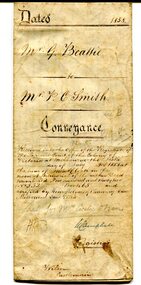
certificate, July 3, 1858
... This is a certificate of indenture, a legal agreement, between George Beattie of Forest Creek, near Castlemaine in the colony of Victoria, and Peter Christian Smith of the same place. ...Orbost & District Historical Society Ruskin Street Orbost gippsland This is a certificate of indenture, a legal agreement, between George Beattie of Forest Creek, near Castlemaine in the colony of Victoria, and Peter Christian Smith of the same place. ...This is a certificate of indenture, a legal agreement, between George Beattie of Forest Creek, near Castlemaine in the colony of Victoria, and Peter Christian Smith of the same place. Both were miners. Beattie was the vendor and Smith paid twenty-five pounds for a land parcel. The contract was witnessed by John Hedderwick, a law clerk in Castlemaine. There is a record in the Mount Alexander Mail, dated Wed. 22 April 1857, of George Beattie purchasing land for three pounds, sixteen and sixpence in Castlemaine and that it was withdrawn. Records also show that a Peter and Thomas Smith farmed in Sandon near Castlemaine.This item is a useful research tool as it a hand-written record of part of the history of the gold fields region of Victoria.A white paper certificate of conveyance with black print and hand-written details from George Beattie to Peter Smith. There is a wax seal on the second page.beattie-george smith-peter-christian castlemaine-certificate-conveyance -
Federation University Historical Collection
Image, Robert Malachy Serjeant
... Once gold was discovered in Victoria, Serjeant made his way to Forest Creek (near Castlemaine) and he and his mate Mr Victor, were the first party to sink through the basalt in search of a deep lead. ...Once gold was discovered in Victoria, Serjeant made his way to Forest Creek (near Castlemaine) and he and his mate Mr Victor, were the first party to sink through the basalt in search of a deep lead. ...ROBERT MALACHY SERJEANT (1828-1902) Robert Malachy Serjeant was born on 21 December 1828 at Callington, Cornwall. He was the son of Philip Davey Serjeant, a surgeon in the Royal Marines, and Eliza Malachy. Philip Serjeant died in 1834. His mother, Eliza, remarried John Burgh in 1836. He died in 1837. In September 1848 Eliza, Robert and his two sisters, Caroline and Susan, departed Plymouth on the William Moneya for Port Adelaide and arrived in January 1849. Once gold was discovered in Victoria, Serjeant made his way to Forest Creek (near Castlemaine) and he and his mate Mr Victor, were the first party to sink through the basalt in search of a deep lead. In 1854 he moved to Ballarat to work as a miner and enjoyed some success. In 1855 he was with a group that discovered a 500 ounce nugget. With his share of the sale he set himself up with the latest mining equipment, as well as beginning a lifelong interest in the share market. He became the Manager of the Chryseis, Isis and Garibaldi claims and then the Manager of the Band and Albion Consol Company. He held the position for thirty years and only resigned when the company amalgamated with the Sir Henry Loch Mine. Robert Malachy Serjeant became interested in Politics. The first election for Parliament Representatives for Ballarat was in 1855. Robert stood for election for the first time in 1859, representing Ballarat West. He was also elected to represent Ballarat West in 1874 and 1880. Robert Serjeant’s community involvement extended to Education. Years of discussion eventually saw the development of the Ballarat School of Mines, the first school of mines in Australia. The inaugural School Council was formed in 1870 with Sir Redmond Barry, the Chief Justice, as President and Robert Malachy Serjeant as a member of the council. He held a position on the council until illness forced him to retire in 1889. He was elected a Life Governor in 1889. He was also a Life Governor of the Ballarat Hospital. Robert Serjeant showed Prince Albert and Prince George (later King George V) around the Band and Albion Mine. At the age of 42, Robert enrolled as a student at the School of Mines in 1871. He obtained a Certificate of Competency in Assaying (including Metallurgy) in 1875. The first certificate in “Geology as Applied to Mining” was awarded to Robert Serjeant in 1876. Robert Serjeant was an active and generous supporter of the School of Mines. As well as being a financial contributor, he lectured and examined in the Principles and Practice of Mining. He was regarded as an authority on alluvial and quartz mining and was a member of the Ballarat Local Court and mining board. In 1977 Robert, Joseph Flude and Henry Caselli donated the patent rights of a novel Pyrites furnace to the school. The R.M. Serjeant Scholarship at the Ballarat School of Mines resulted after a reward was offered for the first to produce the best method of treating auriferous ores – other than the smelting method. The offer was open for two years but not awarded. The money for this was donated by Robert Serjeant to the amount of 256 Pounds. It was then used to fund the School of Mines Scholarship in Engineering (1889). It was first awarded in 1922. Robert Malachy Serjeant died on 25 October 1902 and was buried at the Ballaarat Old Cemetery. (Sometimes Malachy is incorrectly written as Malachi)Two photographic portraits of mine manager Robert Malachy Serjeant. Both portraits were purchased by the donor from the State Library of Victoria. robert malachy serjeant, r.m. sergeant, robert malachi serjeant, band of hope and albion consols -
Federation University Historical Collection
Photograph - Image, Yarrowee Hall, Redan, c1883
...
Once gold was discovered in Victoria, Serjeant made his way to Forest Creek (near Castlemaine) and he and his mate Mr Victor, were the first party to sink through the basalt in search of a deep lead. ...
Once gold was discovered in Victoria, Serjeant made his way to Forest Creek (near Castlemaine) and he and his mate Mr Victor, were the first party to sink through the basalt in search of a deep lead. ...ROBERT MALACHY SERJEANT (1828-1902) Robert Malachy Serjeant was born on 21 December 1828 at Callington, Cornwall. He was the son of Philip Davey Serjeant, a surgeon in the Royal Marines, and Eliza Malachy. Philip Serjeant died in 1834. His mother, Eliza, remarried John Burgh in 1836. He died in 1837. In September 1848 Eliza, Robert and his two sisters, Caroline and Susan, departed Plymouth on the William Moneya for Port Adelaide and arrived in January 1849. Once gold was discovered in Victoria, Serjeant made his way to Forest Creek (near Castlemaine) and he and his mate Mr Victor, were the first party to sink through the basalt in search of a deep lead. In 1854 he moved to Ballarat to work as a miner and enjoyed some success. In 1855 he was with a group that discovered a 500 ounce nugget. With his share of the sale he set himself up with the latest mining equipment, as well as beginning a lifelong interest in the share market. He became the Manager of the Chryseis, Isis and Garibaldi claims and then the Manager of the Band and Albion Consol Company. He held the position for thirty years and only resigned when the company amalgamated with the Sir Henry Loch Mine. Robert Malachy Serjeant became interested in Politics. The first election for Parliament Representatives for Ballarat was in 1855. Robert stood for election for the first time in 1859, representing Ballarat West. He was also elected to represent Ballarat West in 1874 and 1880. Robert Serjeant’s community involvement extended to Education. Years of discussion eventually saw the development of the Ballarat School of Mines, the first school of mines in Australia. The inaugural School Council was formed in 1870 with Sir Redmond Barry, the Chief Justice, as President and Robert Malachy Serjeant as a member of the council. He held a position on the council until illness forced him to retire in 1889. He was elected a Life Governor in 1889. He was also a Life Governor of the Ballarat Hospital. Robert Serjeant showed Prince Albert and Prince George (later King George V) around the Band and Albion Mine. At the age of 42, Robert enrolled as a student at the School of Mines in 1871. He obtained a Certificate of Competency in Assaying (including Metallurgy) in 1875. The first certificate in “Geology as Applied to Mining” was awarded to Robert Serjeant in 1876. Robert Serjeant was an active and generous supporter of the School of Mines. As well as being a financial contributor, he lectured and examined in the Principles and Practice of Mining. He was regarded as an authority on alluvial and quartz mining and was a member of the Ballarat Local Court and mining board. In 1977 Robert, Joseph Flude and Henry Caselli donated the patent rights of a novel Pyrites furnace to the school. The R.M. Serjeant Scholarship at the Ballarat School of Mines resulted after a reward was offered for the first to produce the best method of treating auriferous ores – other than the smelting method. The offer was open for two years but not awarded. The money for this was donated by Robert Serjeant to the amount of 256 Pounds. It was then used to fund the School of Mines Scholarship in Engineering (1889). It was first awarded in 1922. Robert Malachy Serjeant died on 25 October 1902 and was buried at the Ballaarat Old Cemetery. (Sometimes Malachy is incorrectly written as Malachi)An copy of a photo of Yarrowee Hall, the home of of mine manager Robert Malachy Serjeant. robert malachy serjeant, r.m. sergeant, robert malachi serjeant, band of hope and albion consols, yarrowee hall, redan -
 Eltham District Historical Society Inc
Photograph - Digital Photograph, Alan King, Diamond Creek, Barak Bushlands, Eltham, 2008
... Creek Falkiner Street Reserve2 and 35 families joined from the 90-house Estate. Carolyn Mellor, as the Friends’ Land Manager, undertook a four-year horticulture course to guide this massive project for a volunteer organisation. Since 1999, she has been the Friends’ President. In 1999 the Friends urged the Nillumbik Council to undertake a feasibility study into establishing a wetland system and urban forest. Work began in 2002 with Nillumbik Council funding the project, supplemented by government grants. The Friends also received grants from Melbourne Water and Parks Victoria...Creek Falkiner Street Reserve2 and 35 families joined from the 90-house Estate. Carolyn Mellor, as the Friends’ Land Manager, undertook a four-year horticulture course to guide this massive project for a volunteer organisation. Since 1999, she has been the Friends’ President. In 1999 the Friends urged the Nillumbik Council to undertake a feasibility study into establishing a wetland system and urban forest. Work began in 2002 with Nillumbik Council funding the project, supplemented by government grants. The Friends also received grants from Melbourne Water and Parks Victoria ...A habitat corridor and it strengthens the community. Published: Nillumbik Now and Then / Marguerite Marshall 2008; photographs Alan King with Marguerite Marshall.; p185 Barak Bushlands lie west of the Diamond Creek on the corner of Falkiner Street and busy, noisy Main Road. They form part of an important habitat corridor linking the Yarra River to the Kinglake National Park.1 Manna Gums, tawny frogmouths and platypuses are some of the indigenous plants and animals that have made their home there. The bushlands are the result of more than nine years of hard work by the local community with the Nillumbik Council, to transform a degraded flood plain into this refuge of natural beauty. In 1997, shortly after moving into the new Riverside Estate on Falkiner Street, Eltham, several residents noticed the sorry state of the Diamond Creek and surrounding area. Part of it was used as a cow paddock and although small patches of vegetation survived, the area was infested with weeds, rabbits, rubbish and drainage from the housing estate. At various times the 4.4 hectares had been used as a market garden and for shire stock piles. The residents began to restore the area by revegetating land along the Diamond Creek. In 1998 they established the Friends of the Diamond Creek Falkiner Street Reserve2 and 35 families joined from the 90-house Estate. Carolyn Mellor, as the Friends’ Land Manager, undertook a four-year horticulture course to guide this massive project for a volunteer organisation. Since 1999, she has been the Friends’ President. In 1999 the Friends urged the Nillumbik Council to undertake a feasibility study into establishing a wetland system and urban forest. Work began in 2002 with Nillumbik Council funding the project, supplemented by government grants. The Friends also received grants from Melbourne Water and Parks Victoria. Aided by the Friends and other community members, the Council created the Barak Bushlands consisting of a forest, a wetland, a bridge, a path and open space. The beautiful wetland treats most of the estate’s stormwater runoff. Storm water is filtered through plants in the wetland ponds then is released slowly into the billabong, before flowing into the Diamond Creek. The wetland also helps to minimise flooding and the improved water quality provides a flora and fauna habitat. The Friends and other volunteers planted more than 27,000 plants, more than one third of which they grew from seeds they collected at Lower Eltham and Wingrove Parks. Eltham High School students planted thousands of these through a Year Eight program introduced for this purpose. Other groups who assisted were: Green Corps, local Scouts and Guides – 2nd Montmorency, 1st Diamond Creek and 1st Eltham Cub Packs, Eltham College students, Eltham East Primary School, Landcare members, Eltham Lions Club and the Eltham Baptist Church. To maintain enthusiasm for the mammoth task, the Friends and other volunteers ‘adopted’ trees to water and wrote their names on the stakes. In 2004, to recognise the area’s original occupiers, the reserve was named Barak Bushlands. William Barak, who lived from 1824 to 1903, was the last chief of the Yarra Yarra tribe of the Wurundjeri-willam people. Traces of these original inhabitants remain in scar trees (bark sections removed to make a shield or canoe). That same year the Friends’ group was a finalist in the prestigious Federal Government, Banksia Environmental Awards. The Friends have also participated in Clean Up Australia, removing tonnes of rubbish and regularly testing the billabong, wetland and creek, for pollutants. For years the Friends, together with the Australian Platypus Conservancy, have tagged, measured and checked the health of platypuses from the Diamond and Mullum Mullum Creeks. With Latrobe University the Friends have conducted night walks to view owls, possums, bats and sugar gliders. Challenges for the council and the Friends continue with a large rabbit population, some vandalism, weed eradication and maintenance. However, thanks to this community effort, locals can now escape confined urban living on small blocks of land and enjoy the beauty of indigenous plants and animals. Working together has also strengthened the local community,This collection of almost 130 photos about places and people within the Shire of Nillumbik, an urban and rural municipality in Melbourne's north, contributes to an understanding of the history of the Shire. Published in 2008 immediately prior to the Black Saturday bushfires of February 7, 2009, it documents sites that were impacted, and in some cases destroyed by the fires. It includes photographs taken especially for the publication, creating a unique time capsule representing the Shire in the early 21st century. It remains the most recent comprehenesive publication devoted to the Shire's history connecting local residents to the past. nillumbik now and then (marshall-king) collection, barak bushlands, diamond creek (creek), eltham -
 Bendigo Historical Society Inc.
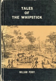
Book - TALES OF THE WHIPSTICK, 1975
... forest. This book contains stories from surrounding areas including Neilborough, Sebastian, Raywood, and the Myers Creek Gold Rushes, Victoria Australia. 250 pages. ...forest. This book contains stories from surrounding areas including Neilborough, Sebastian, Raywood, and the Myers Creek Gold Rushes, Victoria Australia. 250 pages. ...'Tales of the Whipstick'. A history of mining and other activities in the Whipstick forest. This book contains stories from surrounding areas including Neilborough, Sebastian, Raywood, and the Myers Creek Gold Rushes, Victoria Australia. 250 pages. B&W photographs. With Index compiled by Ralph Birrell. Signed by the Author.William Perrybook, bendigo, whipstick -
 Bendigo Historical Society Inc.
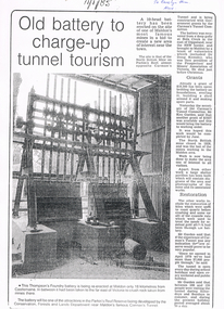
Newspaper - LONG GULLY HISTORY GROUP COLLECTION: 10 HEAD BATTERY
... History House 11 Mackenzie Street Bendigo goldfields BENDIGO History long gully history group The Long Gully History Group - 10 Head Battery Thompson's Foundry Battery Parkin's Reef Reserve Conservation Forests and Lands Department Carman's Tunnel North British Mine Parkins Reef Carman's Tunnel Committee Dr Doug Kemsley Prospectors' and Miners' Association of Victoria Mr Ken Garden Copy of a newspaper article titled Old battery to charge-up tunnel tourism. Date written on the paper is 11/1/85. The Thompson's Foundry Battery was re-erected in the Parkin's Reef Reserve after being used at Bola Creek ...Copy of a newspaper article titled Old battery to charge-up tunnel tourism. Date written on the paper is 11/1/85. The Thompson's Foundry Battery was re-erected in the Parkin's Reef Reserve after being used at Bola Creek near the NSW border. A team of volunteers and a Grant had it moved to Maldon where it was set up and the area made attractive for tourists.bendigo, history, long gully history group, the long gully history group - 10 head battery, thompson's foundry battery, parkin's reef reserve, conservation forests and lands department, carman's tunnel, north british mine, parkins reef, carman's tunnel committee, dr doug kemsley, prospectors' and miners' association of victoria, mr ken garden -
 The Beechworth Burke Museum
Photograph, 1907-8
... El Dorado is located on Reedy Creek and is surrounded by forested country to the north and east. It is 20 km east of Wangaratta in Victoria's regional north-east. ...El Dorado is located on Reedy Creek and is surrounded by forested country to the north and east. It is 20 km east of Wangaratta in Victoria's regional north-east. ...The photo from 1907-8 is a sepia print, depicting a small valley with building at base. There are flumes visible above areas of water, trees on hills and a few small cottages on the hillside. Cock's Pioneer Gold & Tin Sluicing Co NZ No 2 Site. The photo was taken of Matthews Gully looking west. Sluicing was undertaken in the area from 1900 to 1942 with some short breaks between these periods. The image depicts a location mined by Cocks Pioneer Gold and Tin Sluicing Company (as recorded on the annotation on the card mount) The Cocks Pioneer Gold and Tin Mines N.L was one of El Dorado's two largest open cut sluicing mines of the 20th Century. The other was named the Cocks El Dorado Gold Dredging Company. The Cocks Pioneer Mines operated from 1901 until 1941 and found a total of 117,378 ounces of Gold and 1,673 tones of tin concentrates over these years. The Cocks company was formed in 1898 and operated until 1941. Open cut sluicing involved the use of high-powered hoses which used the centrifugal sand pump system (known as hydraulic sluicing) which broke down the soil which was then processed for gold and other precious metals. From 1914 , four years after this image was captured, the company reformed to Cocks Pioneer Gold and Tin Mines NL (previously it was known as Cocks Pioneer Sluicing Co) and undertook large scale sluicing operations until 1929 and then 1934-1941. El Dorado is located on Reedy Creek and is surrounded by forested country to the north and east. It is 20 km east of Wangaratta in Victoria's regional north-east. John Cock was the son of a Cornish minor who arrived in El Dorado in 1858. Cock founded his gold and tin mining company which ran successfully for many years in the El Dorado region. It was an open cut sluicing company because of the abandonment of underground mining after this was deemed too dangerous. In 1935 Cock's El Dorado Company commissioned the floating dredge which is still visible in El Dorado today. The dredge was built by the Thompson engineering works, Castlemaine, and weighed over 2,000 tones and today has a place on the Victorian Registers of historic buildings. Interestingly, the name El Dorado does not derive from the gold in the region, but from the Barambogie pastoral run completed by William Baker in 1840-1841. Gold was discovered in El Dorado 1854 but the gold was too deep for individual prospectors to find, it required the use of heavy machinery.The search for gold is ingrained into the history of Victoria and therefore, images like this one which portray an open cut sluicing site can reveal important information for society and technology for the date when the photograph was taken. This image is of important historical significance for its ability to convey information about sluicing and the methods used to find gold in 1910. It also shows a location where sluicing was undertook which provides insight into the impact of sluicing on the environment at a time when it was done. This image is important for current research into the history of El Dorado, a small regional location near Wangaratta in Victoria's North East. Therefore, this image has the capacity to be beneficial for research into society and the motivations of those living and working in this region during this period and therefore, has social significance. The Beechworth Burke Museum has additional images relating to gold sluicing and El Dorado which can be analysed and studied alongside images like this one.Sepia coloured rectangle photograph printed on gloss photographic paper Reverse: 1997. 2613/ A02613/ No2 site/ Matthews Gully/ Cocks Pioneer G&T. ?? Co NZ/ No2 Site looking West/ 1907-8/ (7)sluicing, hydraulic sluicing, 1907, 1908, mining, cock's pioneer gold & tin sluicing co nz, nz, site no 2, matthews gully, west, valley, building, cottages, hillside, trees, water, gold and tin mine -
 The Beechworth Burke Museum
Photograph, 1910 - 1911
... Victoria, ranking as the second-highest dividend paying mine. The company produced a total of 3,650 kg of gold. El Dorado is located on Reedy Creek and is surrounded by forested country to the north and east. ...Victoria, ranking as the second-highest dividend paying mine. The company produced a total of 3,650 kg of gold. El Dorado is located on Reedy Creek and is surrounded by forested country to the north and east. ...This photograph depicts Cock's Pioneer G & T Sluicing site No. 4 in El Dorado. Looking eastwards, the photo captures a wooden and tin building with various mining equipment strewn in the foreground. Underneath the verandah, figures can be seen. These are believed to be a Mr. Hollister (left), Mrs. Breustedt (4th from left), children Min and Chris Breustedt, and Kate Timmons holding a girl's hand. The Cocks Pioneer Gold and Tin Mines N.L was one of El Dorado's two largest open-cut sluicing mines of the 20th Century. The other was named the Cocks El Dorado Gold Dredging Company. The Cocks Pioneer Mines operated from 1901 until 1941 and found a total of 117,378 ounces of Gold and 1,673 tones of tin concentrates over these years. The Cocks company was formed in 1898 and operated until 1941. Open cut sluicing involved the use of high-powered hoses which used the centrifugal sand pump system (known as hydraulic sluicing) which broke down the soil which was then processed for gold and other precious metals. From 1914, four years after this image was captured, the company reformed to Cocks Pioneer Gold and Tin Mines NL (previously it was known as Cocks Pioneer Sluicing Co) and undertook large-scale sluicing operations until 1929 and then 1934-1941. The Cocks Pioneer was an extremely successful mining company during the 20th century. In the Annual Report of the Secretary for Mines for the year 1915, the Cocks Pioneer was the largest producer of gold and tin collecting 5,535 ozs. of gold and £7,500 of tin. Twenty years later in 1935, Cocks Pioneer was still one of the most profitable mines in Victoria, ranking as the second-highest dividend paying mine. The company produced a total of 3,650 kg of gold. El Dorado is located on Reedy Creek and is surrounded by forested country to the north and east. It is 20 km east of Wangaratta in Victoria's regional northeast. John Cock was the son of a Cornish miner who arrived in El Dorado in 1858. Cock founded his gold and tin mining company which ran successfully for many years in the El Dorado region. It was an open-cut sluicing company because of the abandonment of underground mining after this was deemed too dangerous. In 1935 Cock's El Dorado Company commissioned the floating dredge which is still visible in El Dorado today. The dredge was built by the Thompson engineering works, Castlemaine, and weighed over 2,000 tones and today has a place on the Victorian Registers of historic buildings. Interestingly, the name El Dorado does not derive from the gold in the region, but from the Barambogie pastoral run completed by William Baker in 1840-1841. Gold was discovered in El Dorado in 1854 but the gold was too deep for individual prospectors to find, it required the use of heavy machinery.The search for gold is ingrained into the history of Victoria and therefore, images like this one which portray an open cut sluicing site can reveal important information for society and technology for the date when the photograph was taken. This image is of important historical significance for its ability to convey information about sluicing and the methods used to find gold in 1910. It also shows a location where sluicing was undertook which provides insight into the impact of sluicing on the environment at a time when it was done. This image is important for current research into the history of El Dorado, a small regional location near Wangaratta in Victoria's North East. Therefore, this image has the capacity to be beneficial for research into society and the motivations of those living and working in this region during this period and therefore, has social significance. The Beechworth Burke Museum has additional images relating to gold sluicing and El Dorado which can be analysed and studied alongside images like this one.A black and white copy of a sepia coloured rectangular photograph printed on matte photographic paper mounted on boardObverse: COCKS PIONEER G + T SL CO, N.L. / 1910 - 11 / NO 4 SITE LOOKING EAST / 4 Reverse: 1997.2508 / AUG 29 1909cocks pioneer gold and tin sluicing company, el dorado, mining, sluicing, hydraulic mining, hollister, breustedt, timmons, gold, tin, gold rush, victoria -
 The Beechworth Burke Museum
Photograph, 1910
... El Dorado is located on Reedy Creek and is surrounded by forested country to the north and east. It is 20 km east of Wangaratta in Victoria's regional north-east. ...El Dorado is located on Reedy Creek and is surrounded by forested country to the north and east. It is 20 km east of Wangaratta in Victoria's regional north-east. ...This photograph dating to 1910 depicts an open cut sluicing site located in El Dorado captured looking east up the open cut from the number 3 Barge site. Sluicing was undertaken in the area from 1900 to 1942 with some short breaks between these periods. The image depicts a location mined by Cocks Pioneer Gold and Tin Sluicing Company (as recorded on the annotation on the card mount). It portrays open cut rocks with a crevice in the center of the image where the sluicing was being undertaken. There is a small timber structure on the right of the image which could be an entrance to a mine or supports made of wood to prevent a cave in at the open cut site and above the cut rock there is bush. The timber structure has rail tracks on top of the bridge which could suggest the identification of this structure as a mine entrance. The rail tracks were used for little carts which hauled soil from the mine. The Cocks Pioneer Gold and Tin Mines N.L was one of El Dorado's two largest open cut sluicing mines of the 20th Century. The other was named the Cocks El Dorado Gold Dredging Company. The Cocks Pioneer Mines operated from 1901 until 1941 and found a total of 117,378 ounces of Gold and 1,673 tones of tin concentrates over these years. The Cocks company was formed in 1898 and operated until 1941. Open cut sluicing involved the use of high-powered hoses which used the centrifugal sand pump system (known as hydraulic sluicing) which broke down the soil which was then processed for gold and other precious metals. From 1914 , four years after this image was captured, the company reformed to Cocks Pioneer Gold and Tin Mines NL (previously it was known as Cocks Pioneer Sluicing Co) and undertook large scale sluicing operations until 1929 and then 1934-1941. El Dorado is located on Reedy Creek and is surrounded by forested country to the north and east. It is 20 km east of Wangaratta in Victoria's regional north-east. John Cock was the son of a Cornish minor who arrived in El Dorado in 1858. Cock founded his gold and tin mining company which ran successfully for many years in the El Dorado region. It was an open cut sluicing company because of the abandonment of underground mining after this was deemed too dangerous. In 1935 Cock's El Dorado Company commissioned the floating dredge which is still visible in El Dorado today. The dredge was built by the Thompson engineering works, Castlemaine, and weighed over 2,000 tones and today has a place on the Victorian Registers of historic buildings. Interestingly, the name El Dorado does not derive from the gold in the region, but from the Barambogie pastoral run completed by William Baker in 1840-1841. Gold was discovered in El Dorado 1854 but the gold was too deep for individual prospectors to find, it required the use of heavy machinery.The search for gold is ingrained into the history of Victoria and therefore, images like this one which portray an open cut sluicing site can reveal important information for society and technology for the date when the photograph was taken. This image is of important historical significance for its ability to convey information about sluicing and the methods used to find gold in 1910. It also shows a location where sluicing was undertook which provides insight into the impact of sluicing on the environment at a time when it was done. This image is important for current research into the history of El Dorado, a small regional location near Wangaratta in Victoria's North East. Therefore, this image has the capacity to be beneficial for research into society and the motivations of those living and working in this region during this period and therefore, has social significance. The Beechworth Burke Museum has additional images relating to gold sluicing and El Dorado which can be analysed and studied alongside images like this one.Sepia coloured rectangular photograph printed on gloss photographic paper mounted on board.Obverse: COCKS PIONEER Q + T SL CO, N.L. / 1910 / LOOKING EAST UP OPEN CUT / FROM NO3 BARGE SITE / Reverse: 1997 . 2611 / A02611el dorado, north east gold, sluicing, gold sluicing, hydraulic sluicing, 1910, gold and tin mine, open cut mining, mining, gold mining, north-east victoria, beechworth, burke museum -
 The Beechworth Burke Museum
Animal specimen - Spotted Pardalote, Trustees of the Australian Museum, 1860-1880
... creek banks, the embankments of railway cuttings, and quarries. Its call is characterised by a very clear and repetitive double "ding". The spotted pardalote is common in woodlands and eucalypt forest areas in Australia. This specimen is part of a collection of almost 200 animal specimens that were originally acquired as skins from various institutions across Australia, including the Australian Museum in Sydney and the National Museum of Victoria (known as Museums Victoria since 1983), as well as individuals such as amateur anthropologist Reynell Eveleigh Johns between 1860-1880. ...creek banks, the embankments of railway cuttings, and quarries. Its call is characterised by a very clear and repetitive double "ding". The spotted pardalote is common in woodlands and eucalypt forest areas in Australia. This specimen is part of a collection of almost 200 animal specimens that were originally acquired as skins from various institutions across Australia, including the Australian Museum in Sydney and the National Museum of Victoria (known as Museums Victoria since 1983), as well as individuals such as amateur anthropologist Reynell Eveleigh Johns between 1860-1880. ...The spotted pardalote is the smallest of all Australian birds. It has a tendency to nest in a long horizontal tunnel, often dug into the soil of creek banks, the embankments of railway cuttings, and quarries. Its call is characterised by a very clear and repetitive double "ding". The spotted pardalote is common in woodlands and eucalypt forest areas in Australia. This specimen is part of a collection of almost 200 animal specimens that were originally acquired as skins from various institutions across Australia, including the Australian Museum in Sydney and the National Museum of Victoria (known as Museums Victoria since 1983), as well as individuals such as amateur anthropologist Reynell Eveleigh Johns between 1860-1880. These skins were then mounted by members of the Burke Museum Committee and put-on display in the formal space of the Museum’s original exhibition hall where they continue to be on display. This display of taxidermy mounts initially served to instruct visitors to the Burke Museum of the natural world around them, today it serves as an insight into the collecting habits of the 19th century.This specimen is part of a significant and rare taxidermy mount collection in the Burke Museum. This collection is scientifically and culturally important for reminding us of how science continues to shape our understanding of the modern world. They demonstrate a capacity to hold evidence of how Australia’s fauna history existed in the past and are potentially important for future environmental research. This collection continues to be on display in the Museum and has become a key part to interpreting the collecting habits of the 19th century. One of Australia's smallest native birds, the male spotted pardalotte is covered with small, distinct white spots. Males have a pale eyebrow, a yellow throat and a red rump. Females are similar but have less-distinct markings. 10060 comprises of one male and one female. This specimen stands upon a wooden platform and has an identification tag tied around its legLabel: 14a. / Spotted Diamond Bird / See Catalogue, page 9. /taxidermy mount, cancel, taxidermy, burke museum, beechworth, australian museum, bird, spotted pardalote -
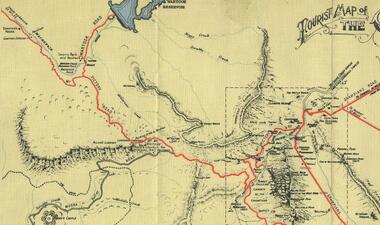 Halls Gap & Grampians Historical Society
Map - Coloured
... Creek Gorge in the late 1850s. Wakeham is credited for the clearing and levelling of the first bridle-path up the gorge. 1870s By the mid 1870s the track had been extended over Valley Gap to the Victoria Forest (the upper region of the Victoria Valley). ...Creek Gorge in the late 1850s. Wakeham is credited for the clearing and levelling of the first bridle-path up the gorge. 1870s By the mid 1870s the track had been extended over Valley Gap to the Victoria Forest (the upper region of the Victoria Valley). ...Background on Bridle Path up Stony Creek Gorge Pre 1840 C. B. Hall, squatter on Mokepilly Run 1841-1842, first European to discover the Fyans Creek valley, the entrance of which became known as Hall's Gap. He later recorded that he followed a number of tracks which he assumed had been made by the Aboriginies and described one as "leading up a wild romantic glen and over on to the source of the Glenelg River". This could well have been the route taken up Stony Creek gorge by the first timber-cutters in this part of the Grampians to the saddle between the Wonderland and Mt. Difficult ranges known as Valley Gap 1850s/60s Timber cutters and shingle splitters were reported to be moving into the eastern side of the Grampians and by the mid 1860s there were a number of families connected to the supplying of timber to Pleasant Creek living in the "Hall's Gap ranges". John Wakeham, the first store owner in Pleasant Creek in 1854, established a timer-mill in upper Stony Creek Gorge in the late 1850s. Wakeham is credited for the clearing and levelling of the first bridle-path up the gorge. 1870s By the mid 1870s the track had been extended over Valley Gap to the Victoria Forest (the upper region of the Victoria Valley). McKeon's bullock team was known to have hauled red gum from the Valley to Stawell in the late 1870s and the 1880s. 1880s In 1887 an article in the Pleasant Creek news describes the Stony Creek Gorge track as "being a ledge alongside the mountain range, formed in the early days with the aid of earth and timber, along which the bullock teams used to travel to Horsham and plains of the Wimmera beyond." 1890s Gold was discovered in the catchment area of Stony Creek and by the end of the 1890s a new track was built from "near the junction of Fyan's and Stony Creeks, up the gorge to the diggings settlement. The mining Department had paid L300 for its construction and, when completed, the track was "three miles and 30 chains in length, the side cuttings at the narrowest part being 10 feet between" and "the watercourses which cross the track at various points" having been "filled up with rocks rolled down the sides of the hills, and consequently there can be no damage caused by bushfires which destroyed the former wooden bridges erected on the old track to Wakeham's saw-mill, the remains of which are still to be seen at the side of the diggings" The article goes on to further describe the track as one which "can with ease travel with a two horse conveyance either up or down" and that the workmen engaged in the construction of the track would be attending "a ball that night at McKeon's farm near the mouth of the gap to celebrate the successful completion of the undertaking". 1900s At what time the bridle path was extended beyond Valley Gap to the Wartook basin on the Mt. Difficult Range has not yet been determined. However, it is known that, by the turn of the century, people were travelling between Halls Gap and the caretakers' residence at Wartook Reservoir along what was now known as the "Bluff Road. Wartook's embankment had been constructed in 1887 and at that time there was already a track from Rosebrook Station homestead (near the present day Wartook Pottery) to the reservoir. Philip Rose owned both Rosebrook and Wartook Stations from the mid 1840s to the late 1850s and had regularly leased the Wartook basin to Cobb & Co. to rest horses there. 1920s Following the war of 1914-1918, tourism really took off in the Grampians, and Halls Gap rapidly grew. People would travel as far as they could on the many tracks then hike to the many lookouts being discovered by local tour guides. This led to the need for access across the range so that horse riders and the increasing number of vehicles could travel between Horsham and Halls Gap. To this end, the Bluff Road was improved and extended on 1929 and at its opening in March, 1930, by Lady Somers it was renamed the Mt. Victory Road.Map of Mt Victory Road and othersaccess routes, mt victory rd, bridle path, roads -
 Halls Gap & Grampians Historical Society
Photograph
... Creek is visible in parts at the foot of the range (middle of Photo). Photo appears to have been taken from Bellfield Pk area. Photo is typical of those taken by Forests Commission of Victoria in the 1960s...Creek is visible in parts at the foot of the range (middle of Photo). Photo appears to have been taken from Bellfield Pk area. Photo is typical of those taken by Forests Commission of Victoria in the 1960s SCENERY Fyans Valley Photo shows a mountain range in the background with a valley. ...Photo depicts Fyans Valley. The road is The Grampians/ Dunkeld Road, leading to Dunkeld towards the right or Halls Gap travelling towards the left. Fyans Creek is visible in parts at the foot of the range (middle of Photo). Photo appears to have been taken from Bellfield Pk area. Photo is typical of those taken by Forests Commission of Victoria in the 1960sPhoto shows a mountain range in the background with a valley. The Valley has a band of a mostly cleared grassy section (middle of photo) with a fairly dense treed area in the foreground. A road and some buildings can be seen where the cleared land meets the treed area.scenery, fyans valley -
 Bendigo Historical Society Inc.
Book - TALES OF THE WHIPSTICK, 1975
... forest. This book contains stories from surrounding areas including Neilborough, Sebastian, Raywood, and the Myers Creek Gold Rushes, Victoria Australia. 250 pages. ...forest. This book contains stories from surrounding areas including Neilborough, Sebastian, Raywood, and the Myers Creek Gold Rushes, Victoria Australia. 250 pages. ...BHS Collection'Tales of the Whipstick'. A history of mining and other activities in the Whipstick forest. This book contains stories from surrounding areas including Neilborough, Sebastian, Raywood, and the Myers Creek Gold Rushes, Victoria Australia. 250 pages. B&W photographs Signed by the Author.William Perrybook, bendigo, whipstick -
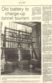 Bendigo Historical Society Inc.
Document - LONG GULLY HISTORY GROUP COLLECTION:OLD BATTERY TO CHARGE-UP TUNNEL TOURISM
... History House 11 Mackenzie Street Bendigo goldfields BHS Collection BENDIGO History long gully history group The Long Gully History Group - Old battery to charge-up tunnel tourism Thompson's Foundry Parkin's Reef Reserve Conservation Forests and lands Department Carman's Tunnel North British Mine Carman's Tunnel Committee Dr Doug Kemsley The Prospectors' and Miners' Association of Victoria Mr Ken Garden Photocopy of a newspaper article titled Old battery to charge-up tunnel tourism. There is a photo of a Thompson's Foundry battery which is being re-erected at the site of the North British mine on Parkin's Reef, near Carman's tunnel. The battery was recovered from a deep gully at Bola Creek ...BHS CollectionPhotocopy of a newspaper article titled Old battery to charge-up tunnel tourism. There is a photo of a Thompson's Foundry battery which is being re-erected at the site of the North British mine on Parkin's Reef, near Carman's tunnel. The battery was recovered from a deep gully at Bola Creek. Other works include restoration of quartz roasting kilns and cyanide vats. Written at the top of the article is a date 11/1/85.bendigo, history, long gully history group, the long gully history group - old battery to charge-up tunnel tourism, thompson's foundry, parkin's reef reserve, conservation forests and lands department, carman's tunnel, north british mine, carman's tunnel committee, dr doug kemsley, the prospectors' and miners' association of victoria, mr ken garden -
 Bendigo Historical Society Inc.
Booklet - From Forest Creek to Eureka, 2023
... 31-page spiral bound booklet by Pat Healy June 2023 'From Forest Creek to Eureka' How the Diggers of the 1850s Gold Rushes drove the developments of Democracy in Victoria. ...History House 11 Mackenzie Street Bendigo goldfields Gold Rush Red Ribbon Agitation Eureka Stockade 31-page spiral bound booklet by Pat Healy June 2023 'From Forest Creek to Eureka' How the Diggers of the 1850s Gold Rushes drove the developments of Democracy in Victoria. ...31-page spiral bound booklet by Pat Healy June 2023 'From Forest Creek to Eureka' How the Diggers of the 1850s Gold Rushes drove the developments of Democracy in Victoria. Includes colour images. Chapters include the Monster Meeting, Red Ribbon Movement in Bendigo, Eureka Stockade in Ballarat Published by Chewton Domain Society 2023gold rush, red ribbon agitation, eureka stockade -
 Bendigo Historical Society Inc.
Painting - S.T GILL GOLDFIELD PRINTS
... Forest Creek to Bendigo. [3] Fryers Creek near Castlemaine. [4] Tin Dish Washing. [5] Diggers Licensing Castlemaine Camps. [6] Eaglehawk Gully Bendigo. Reverse stamped Bendigo Branch Royal Historical Society of Victoria...Forest Creek to Bendigo. [3] Fryers Creek near Castlemaine. [4] Tin Dish Washing. [5] Diggers Licensing Castlemaine Camps. [6] Eaglehawk Gully Bendigo. Reverse stamped Bendigo Branch Royal Historical Society of Victoria ...6 S.T Gill prints titled, [1] 'The Foundation of Eaglehawk in 1852. On the reverse of (1) is a pencil drawing named 'The Road To Allandale, Victor Cobb 1932, [2] Road from Forest Creek to Bendigo. [3] Fryers Creek near Castlemaine. [4] Tin Dish Washing. [5] Diggers Licensing Castlemaine Camps. [6] Eaglehawk Gully Bendigo. Reverse stamped Bendigo Branch Royal Historical Society of Victoria, 1959.bendigo, gold mining, s.t. gill -
 Bendigo Historical Society Inc.
Document - BENDIGO AND DISTRICT IN COLOUR
... Creek... Eaglehawk... Peg Leg... The Garden Gully... New Chum Railway... Great Extended Hustlers...White Death... Chinese... Joss House... Sun Loong Dragon... Victoria Hill... Whipstick Forest...History House 11 Mackenzie Street Bendigo goldfields BENDIGO History gold mining Bendigo Creek Eaglehawk Peg Leg The Garden Gully New Chum Railway Great Extended Hustlers White Death Chinese Joss House Sun Loong Dragon Victoria Hill Whipstick Forest Talking Trams Dia Gum San Village. ...''Bendigo and District in Colour'' Possible full title - see first page. (by Ken and Esther Stepenell). Seven paged very broad coverage of Bendigo's history and attractions. Includes mention of Dai Gum San Village (and proposed site??)Ken and Esther Stepenellbendigo, history, gold mining, bendigo creek, eaglehawk, peg leg, the garden gully, new chum railway, great extended hustlers, white death, chinese, joss house, sun loong dragon, victoria hill, whipstick forest, talking trams, dia gum san village. -
 Bendigo Historical Society Inc.
Book - THE MONSTER MEETING BOOK
... History House 11 Mackenzie Street Bendigo goldfields VICTORIA History monster meeting chewton Jan Wositzky The Monster Meeting Book, how Eureka began with the 1851 Forest Creek monster meeting of diggers, written by Jan'Yarn' Wositzky edited by Patricia Healy published by Chewton Domain Society 2014, in a spring bound binder with 171 pages containing coloured illustrations, photographs and maps. ...The Monster Meeting Book, how Eureka began with the 1851 Forest Creek monster meeting of diggers, written by Jan'Yarn' Wositzky edited by Patricia Healy published by Chewton Domain Society 2014, in a spring bound binder with 171 pages containing coloured illustrations, photographs and maps.Jan Wositzkyvictoria, history, monster meeting chewton -
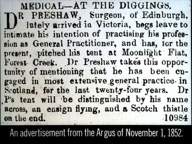 Bendigo Historical Society Inc.
Slide - DIGGERS & MINING. STORES AT THE DIGGINGS, c1852
... Lately arrived in Victoria, beg leave to intimate his intention of practising his profession as General Practitioner, and has, for the present, pitched his tent at Moonlight Flat, Forest Creek, Dr Preshaw takes this opportunity of mentioning that he has been engaged in most extensive general practice, in Scotland, for the last twenty-four years. ...Lately arrived in Victoria, beg leave to intimate his intention of practising his profession as General Practitioner, and has, for the present, pitched his tent at Moonlight Flat, Forest Creek, Dr Preshaw takes this opportunity of mentioning that he has been engaged in most extensive general practice, in Scotland, for the last twenty-four years. ...Diggers & Mining. Stores at the diggings. MEDICAL - AT THE DIGGINGS, Dr Preshaw, Surgeon, of Edinburgh. Lately arrived in Victoria, beg leave to intimate his intention of practising his profession as General Practitioner, and has, for the present, pitched his tent at Moonlight Flat, Forest Creek, Dr Preshaw takes this opportunity of mentioning that he has been engaged in most extensive general practice, in Scotland, for the last twenty-four years. Dr P's tent will be distinguished by his name across, an ensign flying, and a Scotch thistle on the end. 10 984. N ADVERTISMENT FROM THE Argus of November 1, 1852. Markings: 26 994.LIF. 5. Used as a teaching aid.hanimounteducation, tertiary, goldfields -
 Bendigo Historical Society Inc.
Map - PLAN GENERAL SURVEY MALMSBURY PORCUPINE INN, FOREST CREEK TO GOLDEN POINT. ALEXANDRA RANGE 1853
... Forest Creek to Golden Point, shewing (sic) the Alexandrian Range also Sawpit Gully Bendigo and Bullock Creeks. Handwritten note under the title a follows '' Forwarded to the Colonial Secretary with my letter No A 53/105 dated 30th March 1853 for transmission to the Geological Surveyor. R Hoddle Surveyor General. ' Stamped by Department of Mines Victoria...A description of the Map, its history and implications for both historical and future discussions is contained in an Essay 'Mapping Great Changes' : The landscape of central Victoria by Gerry Gill. Map PLAN GENERAL SURVEY MALMSBURY PORCUPINE INN, FOREST CREEK TO GOLDEN POINT. ...Colour Copy of Plan of the General Survey from the Town of Malmsbury to the Porcupine Inn, from the sources of Forest Creek to Golden Point, shewing (sic) the Alexandrian Range also Sawpit Gully Bendigo and Bullock Creeks. Handwritten note under the title a follows '' Forwarded to the Colonial Secretary with my letter No A 53/105 dated 30th March 1853 for transmission to the Geological Surveyor. R Hoddle Surveyor General. ' Stamped by Department of Mines Victoria with record#123 in Top right Hand corner. Also contains a catalogue number 2053/M/2. Part of the Contents of a DVD entitled 'Mapping Great Change' - Archival Maps, produced to support an exhibition in the Post Office Gallery Bendigo. A description of the Map, its history and implications for both historical and future discussions is contained in an Essay 'Mapping Great Changes' : The landscape of central Victoria by Gerry Gill.R. Hoddlemap, bendigo, country lands -
 Bendigo Historical Society Inc.
Document - ROMANCE OF THE GOLDFIELDS
... Forest Creek. Mentions, Messrs. Gibson & Fenton, Mr Robert Ross Haverfield, Kennedy and Farrell, Asquith, Ben Hall, William and Walter Sandbach, Ron O'Donnell, Johnson, Bypass, Latham, Watson, Bell, Mr J B Watson, Mr George Lansell. Also mentions Gold Yields. Mentions Mines - Advance, Great Extended Hustlers, Garden Gully, New Chum, Victoria...Forest Creek Document. 8 page typed document titled 'Romance of the Goldfields'. (2 copies). 'Copy' is typed at the top of document. Mentions the gold rushes of Bendigo and Forest Creek. Mentions, Messrs. Gibson & Fenton, Mr Robert Ross Haverfield, Kennedy and Farrell, Asquith, Ben Hall, William and Walter Sandbach, Ron O'Donnell, Johnson, Bypass, Latham, Watson, Bell, Mr J B Watson, Mr George Lansell. Also mentions Gold Yields. Mentions Mines - Advance, Great Extended Hustlers, Garden Gully, New Chum, Victoria ...Document. 8 page typed document titled 'Romance of the Goldfields'. (2 copies). 'Copy' is typed at the top of document. Mentions the gold rushes of Bendigo and Forest Creek. Mentions, Messrs. Gibson & Fenton, Mr Robert Ross Haverfield, Kennedy and Farrell, Asquith, Ben Hall, William and Walter Sandbach, Ron O'Donnell, Johnson, Bypass, Latham, Watson, Bell, Mr J B Watson, Mr George Lansell. Also mentions Gold Yields. Mentions Mines - Advance, Great Extended Hustlers, Garden Gully, New Chum, Victoria, Kent Mine, Golden Fleece, Richard Heales, Cornish United, Great Extended Hustlers, Tribute Company, Williams United, South New Moon, New Moon, Carlisle Group, Johnson's Reef, North Johnson's, Hercules and '180'. Envelope that this document was in is marked 'Notes re - Romance of Goldfields, Premier Companies, Sebastian Mining Leases, Resources of Bgo Goldfields, Sheepshead Line of Reef'.cottage, miners, romance of the goldfields, bendigo, forest creek -
 Flagstaff Hill Maritime Museum and Village
Craft - Ship Model, Peter Payne, Early 1930s to 1960s
... forest woods used which also included red cedar, silver ash, black bean, Queensland maple and silky oak. It is also believed the model was a design for a clinker-built barge to be built by Peter Payne who operated a boat building works on the Mordialloc Creek, Victoria going out of business in 1973. ...forest woods used which also included red cedar, silver ash, black bean, Queensland maple and silky oak. It is also believed the model was a design for a clinker-built barge to be built by Peter Payne who operated a boat building works on the Mordialloc Creek, Victoria going out of business in 1973. ...Half-hull ship models were an important step in the process of building a vessel. Shipwrights or designers would construct a half-hull scale model of a ship before the vessel was built. They used it to ensure that the dimensions would work together and that the ship look balanced. They would often mount the half hull onto a board in their workshop. The half-hull ship models were also used to show prospective buyers how the design would work and look. Given the plywood construction of the model, it is believed to have been made around the 1930s as plywood construction had started in earnest in Queensland around this time and soon became the centre of the industry because of Queensland's attractive rain forest woods used which also included red cedar, silver ash, black bean, Queensland maple and silky oak. It is also believed the model was a design for a clinker-built barge to be built by Peter Payne who operated a boat building works on the Mordialloc Creek, Victoria going out of business in 1973. Records show Peter Paynes' first craft launched in 1962 and the last in 1973 from Mordialloc Creek works. However, he was one of the most prolific builders from the 1930s and produced many more vessels than the records currently show. There is at this point no further record of the subject model or whether a full version was ever built and for whom is not known at this time.A model that demonstrates the boat-building process is believed to have been made by Peter Payne or someone who worked in his yard. P Payne was a very well-known boating personality, vessel captain and boat builder throughout most of the 20th century. Model barge half hull on wooden of plywood laminated construction. Marked "AUXILIARY BARGE 80'x16'x6' 315 TONS 4" - 1 FOOT" "P and H PAYNE?" "22/E/26" flagstaff hill, warrnambool, flagstaff-hill, flagstaff-hill-maritime-museum, maritime-museum, shipwreck-coast, flagstaff-hill-maritime-village, ship model half hull, ship half model, shipbuilding, shipwright, ship design, peter payne, boat builder victoria, clinker design, barge