Showing 75 items matching "forest walks"
-
 Marysville & District Historical Society
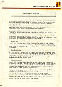
Flyer (Item) - Information Flyer, Forests Commission, Victoria, FOREST WALKS - MARYSVILLE, 1918-1983
... FOREST WALKS - MARYSVILLE......forest walks...An information flyer that was produced as a guide to the forest walks in and near Marysville by the Forests Commission of Victoria. ...An information flyer that was produced as a guide to the forest walks in and near Marysville by the Forests Commission of Victoria....FOREST WALKS - MARYSVILLE Flyer Information Flyer Forests Commission, Victoria ...An information flyer that was produced as a guide to the forest walks in and near Marysville by the Forests Commission of Victoria. The Forests Commission Victoria (FCV) was the main government authority responsible for management and protection of State forests in Victoria, Australia between 1918 and 1983. The Commission was responsible for ″forest policy, prevention and suppression of bushfires, issuing leases and licences, planting and thinning of forests, the development of plantations, reforestation, nurseries, forestry education, the development of commercial timber harvesting and marketing of produce, building and maintaining forest roads, provision of recreation facilities, protection of water, soils and wildlife, forest research and making recommendations on the acquisition or alienation of land for forest purposes″. An extensive network of walking tracks surrounds Marysville and they offer a variety of walks ranging in various levels of difficulty. This information flyer provides information such as the level of difficulty for six suggested walks around Marysville.An information flyer that was produced as a guide to the forest walks in and near Marysville by the Forests Commission of Victoria.marysville, victoria, australia, forest walks, forests commission victoria, beauty spot walk, tree fern gully walk, michaeldene track, keppel track, woods lookout track -
 Marysville & District Historical Society
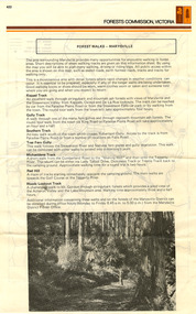
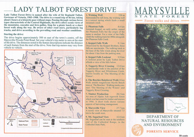
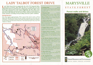
Flyer (item) - Brochure, Department of Natural Resources and Environment-Forest Service, Marysville State Forest-Forest walks and drives-Lady Talbot Forest Drive, Pre 2009
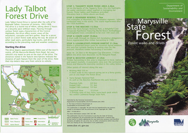
... Marysville State Forest-Forest walks and drives-Lady Talbot Forest Drive...forest drive...lady talbot drive...sir reginald talbot...lady sarah elizabeth talbot...marysville...wishing well...phantom falls...keppel falls walk...Marysville State Forest-Forest walks and drives-Lady Talbot Forest Drive Flyer Brochure Department of Natural Resources and Environment-Forest Service ...A brochure that was produced as a guide to Lady Talbot Forest Drive in Marysville in Victoria.A brochure that was produced as a guide to Lady Talbot Forest Drive in Marysville in Victoria. Lady Talbot Drive a 24 kilometer scenic rainforest car journey which passes a number of walks and waterfalls in the Yarra Ranges National Park. Lady Talbot Drive is named after Lady Sarah Elizabeth, the wife of Sir Reginald Talbot, who was the Governor of Victoria from 25th April, 1904 to 6th July 1908.50 cents Bob McNamara/ Real Estate Agent/ Tourism Info Centre Co-Ordinatorlady talbot forest drive, lady talbot drive, sir reginald talbot, lady sarah elizabeth talbot, marysville, wishing well, phantom falls, keppel falls walk, keppel falls lookout, taggerty river, beeches rainforest walk, logging, mount sugarloaf, victoria -
 Marysville & District Historical Society
Flyer (item) - Brochure, Natural Resources and Evironment, Marysville State Forest-Forest walks and drives-Lady Talbot Forest Drive, Pre 2009
... Marysville State Forest-Forest walks and drives-Lady Talbot Forest Drive...forest drive...lady talbot drive...sir reginald talbot...lady sarah elizabeth talbot...marysville...wishing well...phantom falls...keppel falls walk...Marysville State Forest-Forest walks and drives-Lady Talbot Forest Drive Flyer Brochure Natural Resources and Evironment ...A brochure that was produced as a guide to Lady Talbot Forest Drive in Marysville in Victoria.A brochure that was produced as a guide to Lady Talbot Forest Drive in Marysville in Victoria. Lady Talbot Drive a 24 kilometer scenic rainforest car journey which passes a number of walks and waterfalls in the Yarra Ranges National Park. Lady Talbot Drive is named after Lady Sarah Elizabeth, the wife of Sir Reginald Talbot, who was the Governor of Victoria from 25th April, 1904 to 6th July 1908.lady talbot forest drive, lady talbot drive, sir reginald talbot, lady sarah elizabeth talbot, marysville, wishing well, phantom falls, keppel falls walk, keppel falls lookout, taggerty river, beeches rainforest walk, logging, mount sugarloaf, victoria -
 Marysville & District Historical Society
Flyer (item) - Brochure, Dept. Sustainability & Environment, Marysville State Forest-Forest walks and drives-Lady Talbot Forest Drive, 2003
... Marysville State Forest-Forest walks and drives-Lady Talbot Forest Drive...forest drive...lady talbot drive...sir reginald talbot...lady sarah elizabeth talbot...marysville...wishing well...phantom falls...keppel falls walk...Marysville State Forest-Forest walks and drives-Lady Talbot Forest Drive Flyer Brochure Dept. ...A brochure that was produced as a guide to Lady Talbot Forest Drive in Marysville in Victoria.A brochure that was produced as a guide to Lady Talbot Forest Drive in Marysville in Victoria. Lady Talbot Drive a 24 kilometer scenic rainforest car journey which passes a number of walks and waterfalls in the Yarra Ranges National Park. Lady Talbot Drive is named after Lady Sarah Elizabeth, the wife of Sir Reginald Talbot, who was the Governor of Victoria from 25th April, 1904 to 6th July 1908.ISBN 1 74106 695 6lady talbot forest drive, lady talbot drive, sir reginald talbot, lady sarah elizabeth talbot, marysville, wishing well, phantom falls, keppel falls walk, keppel falls lookout, taggerty river, beeches rainforest walk, logging, mount sugarloaf, victoria, leadbeater's possum, beckter lookout, steavenson falls, isbn 1 74106 695 6 -
 Marysville & District Historical Society
Ephemera (Item) - Information brochure, Department of Sustainability and Environment, Marysville State Forest, 2003
... An information brochure on various forest walks and drives throughout the Marysville State Forest that was published by the Victorian Department of Sustainability and Environment in 2003....An information brochure on various forest walks and drives throughout the Marysville State Forest that was published by the Victorian Department of Sustainability and Environment in 2003....Marysville & District Historical Society 39 Darwin Street Marysville yarra-valley-and-the-dandenong-ranges An information brochure on various forest walks and drives throughout the Marysville State Forest that was published by the Victorian Department of Sustainability and Environment in 2003. ...An information brochure on various forest walks and drives throughout the Marysville State Forest that was published by the Victorian Department of Sustainability and Environment in 2003.An information brochure on various forest walks and drives throughout the Marysville State Forest that was published by the Victorian Department of Sustainability and Environment in 2003.marysville, victoria, australia, information brochure, marysville state forest, lady talbot forest drive, taggerty river picnic area, the beeches, coupe loop, leadbeater's possum, beckter lookout, steavenson falls, marysville visitor information centre, department of sustainability & environmnet, lake mountain, cambarville, yarra ranges national park, cathedral range state park, murrindindi scenic reserve, gilberts gully loop, beauty spot nature trail, trestle track, michaeldene track, keppel lookout, marysville tour -
 Bendigo Military Museum
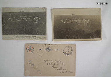
Postcard - POSTCARD - HURDCOTT, AIF CAMP, UK, R. H. Baron, 3. 3/11/1918
... Handwritten in black ink on back: 'This map has been cut in the hill and is only about 10 minutes walk from here, Bob' 3. Handwritten in black ink on front: 'Miss M. Baron, 208 Forest St. ...Handwritten in black ink on back: 'This map has been cut in the hill and is only about 10 minutes walk from here, Bob' 3. Handwritten in black ink on front: 'Miss M. Baron, 208 Forest St. ...Cards relate to R.H. Baron's time at Hurdcott AIF Camp during 1918. Part of the "Robert H. Baron", No. 3596, and Cooper Collection. See Catalogue No. 1981P for details of Baron's service.1. Black and white newspaper clipping pasted onto a piece of cream card. Clipping features a black and white photograph of a map of Australia carved into the side of a hill. Caption in black type below photograph. 2. Black and white postcard style photograph of a map of Australia carved into the side of a hill. 3. Plain cream coloured postcard with YMCA logo and AIF insignia at the top. Handwritten address on front and handwritten letter on back.1. Handwritten in black ink on back: 'This map has been cut in the hill and is only about 10 minutes walk from here, Bob' 3. Handwritten in black ink on front: 'Miss M. Baron, 208 Forest St. Bendigo, Victoria, Australia'. Stamped in black on top R.H.C. of front: 'Postmark - AIF Camp P.O. No.4, 18,' Handwritten in black ink on back: 'Letter to R.H. Baron's sister Myrtle from Hurdcott Camp dated 3.11.18.'robert h. baron, cooper collection, postcards, hurdcott aif camp -
 Federation University Historical Collection
Document, Zelda Martin, Central Victorian Goldmining towns - Boom Towns or Ghost Towns?, c1996
... *Three articles published by Buninyong and District Historical Society Inc: (Magpie Exploration; Finding Gold In The Green Hills; Magpie Exploration; Burnt Bridge to Cargarie to Mt Mercer) *Copies of newspaper articles/items *Buninyong Street Directory Carisbrook: *In the Beginning There Was Carisbrook *The History of the Carisbrook Racecourse Carngham / Snake Valley: *Brief History *Directory Castlemaine: *Directory 1865-1866 - Alphabetical and Street *Poster - Castlemaine A Contemporary Guide "The Great Centre" 1866 - A Contemporary Guide to the Fascinating Past *Pamphlet - Castlemaine District Community Hospital *Map - Castlemaine, Maldon & Surrounding Districts *Map and Information - The Dry Diggings Track - a 55kl walk among historic goldfields relics ( Castlemaine Fryerstown Vaughan Mt Franklin Hepburn Daylesford) *Postcard - Former Court House *Directory 1867 - Alphabetical, Trade [.10] Resource No.3 Grey folder Titled Towns 3 Creswick to Maryborough Creswick: *Brief History *Booklet - "Creswick Cemetery Walk" *Booklet - The Buried Rivers of Gold Heritage Trail Creswick *Creswick Historical Museum Information Sheet *Chronological History of Creswick *Alphabetical Directory of the Borough of Creswick *Creswick's Creek Directory 1856 *Historic Creswick Walking Tour *A Brief Account of the Schools of Creswick - Past and Present *100 Years of Railway Travel in Creswick *The Berry Deep Leads *The Spence Home at Jackass Gully in the Creswick State Forest ( William Guthrie Spence - Pioneer) *The New Australian Mine and the 1882 Disaster *Creswick District News, Issue 7, July August 1999 *The Creswick Miners Walk - Information and Map *Maps Chewton: *Brief History *Directory Clunes: *Brief History *Clunes Street Directory Daylesford: *Brief History *Notable Bushfires in Daylesford District Over More Than a Century - "Black Thursday" 1851; 1862; 1899; the Disastrous Hepburn Fire of 1906; 1939; 1944; 1969. ...*Three articles published by Buninyong and District Historical Society Inc: (Magpie Exploration; Finding Gold In The Green Hills; Magpie Exploration; Burnt Bridge to Cargarie to Mt Mercer) *Copies of newspaper articles/items *Buninyong Street Directory Carisbrook: *In the Beginning There Was Carisbrook *The History of the Carisbrook Racecourse Carngham / Snake Valley: *Brief History *Directory Castlemaine: *Directory 1865-1866 - Alphabetical and Street *Poster - Castlemaine A Contemporary Guide "The Great Centre" 1866 - A Contemporary Guide to the Fascinating Past *Pamphlet - Castlemaine District Community Hospital *Map - Castlemaine, Maldon & Surrounding Districts *Map and Information - The Dry Diggings Track - a 55kl walk among historic goldfields relics ( Castlemaine Fryerstown Vaughan Mt Franklin Hepburn Daylesford) *Postcard - Former Court House *Directory 1867 - Alphabetical, Trade [.10] Resource No.3 Grey folder Titled Towns 3 Creswick to Maryborough Creswick: *Brief History *Booklet - "Creswick Cemetery Walk" *Booklet - The Buried Rivers of Gold Heritage Trail Creswick *Creswick Historical Museum Information Sheet *Chronological History of Creswick *Alphabetical Directory of the Borough of Creswick *Creswick's Creek Directory 1856 *Historic Creswick Walking Tour *A Brief Account of the Schools of Creswick - Past and Present *100 Years of Railway Travel in Creswick *The Berry Deep Leads *The Spence Home at Jackass Gully in the Creswick State Forest ( William Guthrie Spence - Pioneer) *The New Australian Mine and the 1882 Disaster *Creswick District News, Issue 7, July August 1999 *The Creswick Miners Walk - Information and Map *Maps Chewton: *Brief History *Directory Clunes: *Brief History *Clunes Street Directory Daylesford: *Brief History *Notable Bushfires in Daylesford District Over More Than a Century - "Black Thursday" 1851; 1862; 1899; the Disastrous Hepburn Fire of 1906; 1939; 1944; 1969. ...Zelda Martin was a PhD candidate at the University of Melbourne.[.1] 4th item in light blue display book titled Research Approach/Overview of Chapters/Confirmation of Canditure/Chapters1,2,3&4 of proposed thesis. *Twenty-seven page article on Victorian goldfields towns titled: Central Victorian Goldmining Towns - Boom Towns or Ghost Towns. The article was written during the author's PhD study. It outlines the context methodology, and resources and the chapters of the proposed thesis: (1) Central Victorian Goldmining Towns - The Context (2) Contemporary Views of the Factors Necessary for Town Growth (3) Outward Manifestations of Town Growth (4) The Trappings of Government (5-9) The Main Towns and Their Hinterland. [.2] 5th item in Light Blue display book as above item. *Chapter 1 of proposed thesis titled 'Pick, Shovel and Tin Dish Mining.' Covers in Section A: Central Victoria - Pre 1851: Aborigines in Central Victoria, Squatters, and Government. Section B: The years 1851-1854: The Early Gold Rushes, Government Reaction, Township Surveys, Legislation, Town Development, Local Government and Early Settlement. [.3] 6th item in Light Blue display book as above item. *2A of proposed thesis titled 'Contemporary Views of the Factors Necessary for Town Growth'. Similar information to Chapter 1 plus extra re towns and maps. Sections: Introduction, Context of Place - Geographical Towns Listed, The Context of Time - Pre1851 Aborigines, Governance of Port Phillip, The Squatters, The Villages of Central Victorian Highlands, Conclusion, Condensed Version of Chapter2B. [.4] 7th item in Light Blue display book as above item. *Chapter2B of proposed thesis. Sections: Area of Research, Schools, Banks, Newspapers, Progress Association, Town Development - Sandhurst (Bendigo), Ballarat, Castlemaine,, Maryborough, Ararat and Stawell. [.5] 8th item in Light Blue display book as above item. *Chapter 3 of proposed thesis titled 'Outward Manifestations of Town Growth'. Sections: Introduction, Contemporary Writing, Educationalists, The Bankers, The Townsfolk, Current Theory, General Theories of Urban Development, and Conclusion. [.6] 9th item in Light Blue display book as above item. *Chapter 4 of proposed thesis titled 'Trappings of Government' Sections: Introduction, Early Government Attitudes to Mining and Town Development, Law and Order, Township Surveys, Legislation, Local Government, Transport and Communication, The People and Lobbyists. [.7] 10th item in Light Blue display book as above item. *'The Rise and Fall of Central Victorian Goldmining Towns'. Includes a map showing main Goldfields, a table showing towns and villages at two points in time - 1857 and 1871; a Bibliography of Primary and Secondary Sources. [.8] Resource No1. Black display book titled Local Towns 1 : Alma: *Brief history *Directory *Maps Amphitheatre / Mountain Hut: *Brief History Post Office Directory Ararat: *Brief History *Post Office Directory 1869 - Alphabetical Listing by Occupation *Ararat - Prominent Citizens of 1858 *Langi-Morgala Museum Avoca: *Brief History *Excerpts from 'Avoca The Early Years', Margery and Betty Beavis; pg1 - Beginnings; pg11 - The Midas Touch; pg25 - Local Gold Escorts; pg27 - A Town is Born; pg51- The Administration of Justice; pg53 - The Ways of the Law; pg61 - News of the Day; pg65 - A Time to Play; pg72 - Land Ownership *Post Office Directory (Bailliere's) 1869 *Tourism Map and Information of area *Historic Avoca - A 5.5km Tour *Avoca & the Pyrenees Region - information pamphlet Ballarat: *Early History of Ballarat - Ballarat Historical Society, Publication No.1: origin of the name; Ballaarat - the Beginning; Fabulous Yields from the Ballaarat Goldfield; *Streetscape Lydiard Street. *Hand drawn map showing Leigh River, Old Portland Bay Road, plaque on road to Colac; etc. *Newspaper article re 'The Theatre Royal' ( which stood in the vicinity of the current Owen Williams store) - 'The News'15/04/1998 *Article - 'Ballarat's Mechanics' Institute Lives On' Ballarat Courier, 14/09/1985 *Article - Standing the Test of Time' The News 17/11/1993 re The Mechanics Institute & picture of the Reading Room *'Ballarat a Study of a City, Phyllis Reichl, pub. Nelson, 1968; no.3 place, time and people field studies series *Investigator Vol.33 No.2, 1998 Geelong Historical Society. Article on pg75 describes Ballarat in 1861 *Folded poster - 'Ballarat 100' a history of telegraph communication, pub. Telecom. Beaufort (Fiery Creek): *Brief history *Post Office Directory [.9] Resource No.2 Black Folder Titled Towns cont.No2 Bendigo (Sandhurst): *'Family & Local History at the Bendigo Library - 1851-2001 150 years of gold'. *Bendigo Government Camp in 1853 illustration; key to sketch and names of Government officers stationed there *Excerpts from 'Bendigo and Vicinity' Adolph Haman *The Bendigo Goldfield Registry - pgs 1-7 Introduction *Excerpt: 'Breaking the Grip' *Excerpt: The Most Go-Ahead Place *Excerpts from 'History of Bendigo' - anti license agitation; laying out of town; proposed railway; gold calls and dividends; the Sandhurst Municipality; journalism *Bibliography Blackwood: *Excerpts from 'Aspects of Early Blackwood - The Goldfield, the Landmarks, the Pioneers' Alan J Buckingham and Margaret F Hitchcock, JG Publishing,1980 Buninyong: *A Brief History *Investigator Vol1 No.2 Feb 1966 Geelong Historical Society. Pg3 - Article re gold escort route - Mt Alexander to Adelaide - (see a simple monument on the Western Highway a few miles out of Horsham. Pg 15 - Ballarat Excursion - re the finding of gold. *Three articles published by Buninyong and District Historical Society Inc: (Magpie Exploration; Finding Gold In The Green Hills; Magpie Exploration; Burnt Bridge to Cargarie to Mt Mercer) *Copies of newspaper articles/items *Buninyong Street Directory Carisbrook: *In the Beginning There Was Carisbrook *The History of the Carisbrook Racecourse Carngham / Snake Valley: *Brief History *Directory Castlemaine: *Directory 1865-1866 - Alphabetical and Street *Poster - Castlemaine A Contemporary Guide "The Great Centre" 1866 - A Contemporary Guide to the Fascinating Past *Pamphlet - Castlemaine District Community Hospital *Map - Castlemaine, Maldon & Surrounding Districts *Map and Information - The Dry Diggings Track - a 55kl walk among historic goldfields relics ( Castlemaine Fryerstown Vaughan Mt Franklin Hepburn Daylesford) *Postcard - Former Court House *Directory 1867 - Alphabetical, Trade [.10] Resource No.3 Grey folder Titled Towns 3 Creswick to Maryborough Creswick: *Brief History *Booklet - "Creswick Cemetery Walk" *Booklet - The Buried Rivers of Gold Heritage Trail Creswick *Creswick Historical Museum Information Sheet *Chronological History of Creswick *Alphabetical Directory of the Borough of Creswick *Creswick's Creek Directory 1856 *Historic Creswick Walking Tour *A Brief Account of the Schools of Creswick - Past and Present *100 Years of Railway Travel in Creswick *The Berry Deep Leads *The Spence Home at Jackass Gully in the Creswick State Forest ( William Guthrie Spence - Pioneer) *The New Australian Mine and the 1882 Disaster *Creswick District News, Issue 7, July August 1999 *The Creswick Miners Walk - Information and Map *Maps Chewton: *Brief History *Directory Clunes: *Brief History *Clunes Street Directory Daylesford: *Brief History *Notable Bushfires in Daylesford District Over More Than a Century - "Black Thursday" 1851; 1862; 1899; the Disastrous Hepburn Fire of 1906; 1939; 1944; 1969. *Post Office Directory -Daylesford and Hepburn Dunolly / Inkerman: *Brief History *Directory *Pamphlet - Goldfields Historical Museum *Pamphlet - Historic Dunolly - Victoria's Best Kept Secret *Map of Gold Workings at Dunolly Area - showing where the main gold rushes occurred *Brief History - Inglewood *Directory - Inglewood - Name Occupation, Dwelling Kingower: *Brief History *Directory - Name / Ocupation / Dwelling Linton / Happy Valley / Piggoreet: *Brief History *Directory - Lintons McIvor: *"A History of the Shire and the Township of Heathcote" by J.O. Randell Majorca: *Brief History *Official Post Office Directory 1869 - Name / Occupation/ Address Maldon (Tarrangower): *Brief History Part 1 *Brief History Part 2 *Post Office Directory *List - Alphabetical Order by Names plus Business and Trade (Tarrangower Times Oct/1858) *List - Alphabetical Order by Trade plus Name and Business *Directory - Name / Occupation / Dwelling Maryborough: *Worsley Cottage - built by Arthur Worsley, a contractor in stonework in 1894 [.11] Resource No. 4 Blue Display Book titled Towns 4 Moliagul to Stawell Moliagul: *Brief History *Moligul Legislative Assembly (Voting?) List - Names and Occupations *Moliagul Victorian Post Office Directory 1868 - Name / Ocupation / Address / Comments *"The Welcome Stranger" gold nugget *The Sunday School *The Welcome Stranger Discovery Walk - information and map Moonambel (Mountain Creek) Redbank *Brief History *List of names extracted from advertisments of the Pioneer and Mountain Creek Advertiser 16/02/1861. *Bailliere's Directory 1869 - Alphabetical List of Name / Occupation / Place St Arnaud: *Brief History Sebastapol: *Brief History *Directory 1869 - Alphabetical by Name; plus occupation and address. Browns and Scarsdale: *Brief History *Browns Street Directory - Name and Occupation Smythesdale: *Brief Description *Smythesdale Street Directory -Name and Occupation Stawell (Pleasant Creek) *Brief History *Victorian Official Post Office Directory - Name /Occupation / Dwelling *Chronology - 1841-1920 *Production of gold statistics - 1879 - 1900 *Big Hill *Extracts from "The Golden Years of Stawell". Chapt 1 - Stawell's Coming Out. Capt. 2 - The Gold Rush. Caapt.3 - Cradle of Democracy. Chapt.4 - The Reefs Becomes Stawell. Chapt. 5 - Rushing In. Chapt.6 - The Pioneers. Chapt 7 - The Decade of Optimism. [.12] Resource No. 5: Blue Display Book titled 'Towns Steiglitz to the The Golden Triangle. Steiglitz: Brief History Victorian Post Office Directory 1869 *Map of Steiglitz *List of maps relevant to Steiglitz history *Information 6 tables of data from "Reports of Mining Surveyors Talbot (Back Creek) Brief History Taradale: Post office Directory 1869 - Name/Occupation/Street. Also list in alphabetical order by Occupation Taradale *Chronological Reference to Taradale Mines *Water - The Coliban System of Waterworks *Joseph Brady *The Syphon Tarnagulla (Sandy Creek) *Brief History *Tarnagulla Businessmen Cameos to give depth to advertisments in 'The Tarnagulla Courier' various issues 1864-1871 *Directory - Name/Occupation /Address *List - Name/Business/Trade Wedderburn (Koorong) *Brief History *List - Name/Occupation The Golden Triangle: *The Early Rushes - Wedderburn / Moliagul / Sandy Creek - Tarnagulla / Jones Creek - Waanyarra / Kingower / Dunolly - Goldsborough / Inglweood *Census of 1857 - Population / Occupations *1858-1871 - A Time of Consolidation- Wedderburn / Moliagul / Sandy Creek- Tarnagulla / Arnold *Census 1871 - Population *Information gleaned from the census data - Demographics / Population / Occupations / marital / Birthplace / Religion / Literacy/ Occupation and Housing Cameos *Graphs - Birthplace of settlers /Male-Female Ratio / Married males / Children under 15 as Percentage of Population / Religion *Census 1857 - Statistical data *Maps *Bibliography [.13] Resource No. 6 - Black Display Book Information and Research in Central Victoria including: *Banking - Research from ANZ Bank Archives *Institutions - also includes articles listed from the Ballarat Times Newspaper *Australian mining History Association - A.M.H.A. Bibliography *Australia's Mining History * Bibliography - Land Surveys Victoria - *1853 Administration (Statistics and Other) includes: schools / ministers of religion / police / military / local administration / licences for sale of spirits / distances between various Victorian gold fields. * Victoria Government Gazette (Copy) - N0. 116, 12/12/1854 includes: Gold Felds Commission of Enquiry & No. 85, 15/09/1854 - Addresses presented to the Lieutenant Governor (Sir Charles Hotham) during his tour through the Gold Fields of Victoria,1854. Addresses on behalf of : the people of Bendigo; Members of the Church of England, Bendigo; Members of the Wesleyan Church on the Bendigo Gold Fields; Bendigo Gold District General Hospital; the Bendigo Prospecting Association; Committee of the Bendigo Local Exhibition; Bendigo District Medical Association; Coloured Americans Resident at Bendigo; German Inhabitants of Bendigo; Landowners, Inhabitants, and Miners of Castlemaine; Inhabitants of Forest Creek; Inhabitants of Heathcote and Gold Miners of McIvor; Residents and landholders of the District of Bacchus Marsh; Inhabitants of Kilmore and Vicinity. *Gold Fields Correspondence 1853: letter from Lieutenant Colonel Valiant, (Officer commanding the Troops in Victoria) to the Lieutenant Governor re threatened disturbance at Sandhurst (Bendigo) regarding the Gold License Fee. * Extracts from a book "Victoria" re Gold Fields Commission of Enquiry involving mainly Ballarat and Castlemaine and a chapter titled 'A Tour to the Victorian Gold-Fields' *Lists of central Victorian newspapers - listed by date published 1851to 1874; by first date available to State Library. *A list of cities and towns showing County, population in 1861 &1871, and municipal status. [.14] Resource no.7. Black display book. *Reference: Papers presented to Parliament Victoria - 1859-1860 4 volumes - relevant sections copied. Contains information on Branches of Government. General / Finance / Gold / Gazette / Commission and Warrant / Statistic. *Gold Fields Act. In accordance with the Act the gold fields are divided into six districts - Ballaarat, Castlemaine , Sandhurst, Avoca, Ararat, and Beechworth.. Official staff in each gold district consists of a Resident Warden, Wardens, Wardens' Clerks, Bailiffs, Chinese Protectors, Chinese Interpreters, and Mining Surveyors. *Gold Receiver *Gaols *Police magistrates and Clerks of Petty Sessions, etc. *Field Branch *Immigration and Emigration Overland - Chinese - 1859 *Population on the Goldfields *The Geological Survey - The Government Geologist is assisited by staff from four branches - the office Branch; the Publishing Branch; the Field Branch and the Museum Branch. *Commission to Enquire Into Sludge dated 10/02/1859 (Some sections copied) - Report to the Honorable Chief Commissioner of Public Works, Melbourne re the mode of carrying the sludge from the puddling mills in Sandhurst without interfering with the drainage of the town and the roads in the neighbourhood. [.15] Resource No.8: Camel display book titled Resource No. 8. Aborigines *Lists of book titles - +"Readings in Victorian prehistory" +"The Aborigines of Port Phillip" +Aboriginal languages and clans" +"A History of the Port Phillip District" +"Langi Ghiran 1: Aboriginal Rock...." +"Koorie History: sources for aboriginal studies in the State Library of Victoria", ed. Tom Griffiths, Melb. Friends of the State Library, 1989 +"The Public Lands of Australia Felix"; settlement and land appraisal in Victoria1834-91 with special reference to the Western Plains", J.M.Powell, Melb. Oxford University Press 1970 +*Bibliography of the Victorian Aborigines' from the earliest manuscripts to 31st December 1970, Massoa, Aldo, Melb. Hawthorn Press, 1971 +"Aborigines in Colonial Victoria, 1836-1886", M.F. Christie, Sydney University Press, 1979 +"Urban and Industrial Australia: readings in Human Geography" ed J.M. Powell, Melb. Sorrett Pub. 1974 *Extracts: -Processes of Pioneer Settlement - The Squatting Occupation of Victoria, 1834-60. J.M. Powell -Areal Variations in the Class Structure of the Central-Place Hierarchy. P. Scott - Volume1 and Volume 2: Notes Relating to the Habits of the Natives of Other Parts of Australia and Tasmania. Compiled from various sources for the Government of Victoria by R Brough Smyth. John Curry, O'Neil, Melb. 1st pub. Melb. 1876. p31-45 - Numbers and Distribution of the Aborigines in Victoria -Victorian Aborigines 1835-1901 - A Resource Guide to the Holdings of the Public Record Office, Victoria; published by the Government Information Centre 1984. *History of the Aboriginal Artefacts Displayed in the Daylesford Museum. F. G. Powell (4 page pamphlet) *Letter to Zelda Martin from Peter Lovett, Cultural Officer, Ballarat & District Aboriginal Co- Operative, 05/02/1997 *Map: Ian Clarke Victorian Tribunal Boundary Map - Clans of Central Victoria. *Victorian Rock Art and Mythology - Article about Mount Langhi Ghiran and myths of the Tjapwarong people. *Two Aboriginal myths relating to the Grampians - 'The Monster Emu' / 'The Aquisition of Fire', by the Aborigines in the Grampians Areas *Article titled (chapter 8) Ballarat - information re camping sites in the region. Lake Wendouree / Lake Burrumbeet (includes a myth) / Mt Bunninyong / Lal Lal / Pitfield / Mount Elephant / Mount Egerton / Meredith / Lake Goldsmith / Lake Learmonth / Ercildoune *Notes on the Aborigines of the Wider Ballarat Region plus European names=Aboriginal names. John Morris 26/07/1995 *Role of Aborigines in Town Development in Central Victoria. Mentions Native Police Force est. in Port Phillip 1842 and Central Board for Aborigines est. 1860 *The Grave of King Billy. (Frank Wilson) Pamphlet. *Camping Places in Central and Northern Victoria. Article re Lake Burrumbeet site. *Programme for the Unveiling of Memorial Cairn for Edward Stone Parker 1802-1865. Note portrait not accurate. Accurate portrait is available in the book "A Successful Failure A Trilogy The Aborigines and Early Settlers", Edgar Morrison, Graffiti Publications, 2002. * Large envelope addressed to Mr G Netherway containing newspaper cuttings regarding the life of Edward Stone Parker, the unveiling of the Memorial Cairn as mentioned above, articles titled 'Episodes from Our Early Days' (Edgar Morrison, Yandoit)- The Black's School, A School At Last and The Final years. Also a typed page titled 'Historical Background to E.S.Parker's Career. Includes an interesting tale titled 'When the cat lay doggo' re laying power leads for the unveiling ceremony at the memorial site. [.16] green display folder titled 'Research Aids' *List of references to Commissioners' & W'ardens' Reports (formerly held at La Trobe Library Archives, now at Public Records Office [PRO]). Indicates town referred to / date of report / name of camp if different to town. * Archive information re Anglican Records *Movement around the Goldfields - Miners and Storekeepers - usefulness of newspapers in providing information - areas covered - Castlemaine, Maldon, Ararat, Stawell, Tarnagulla, Dunolly. *Port Phillip /Victoria Directories 1839/1867 - Chronological list of Directories included in this series. *"Notes on the History of Local Government in Victoria" A.W. Greig Melb. University Press 1925 - Photo-copied extract p5-p40. (Source - Deakin University Library) - Introduction by W.Harrison Moore. Section 1 - Development in New South Wales Before Separation. Section 2 - Development in Victoria After Its Separation from New South Wales. Hand written notations: 'roads, markets, and local government 1855 on' ;'opportunity of squatters in parliament' and 'opportunities of matters in parliament p33' * Notes on the Establishment of Surveyor General's Department 1851and Commissioner of Crown Lands and Survey. * Newspaper articles from The Argus, 1849, re the discovery of gold in the Pyrenees region. * Excerpt - a report on schools - A.B.Orlebar, Inspector; re the need for permanent school buildings rather than tents. *Excerpt from - 'Approaches to Urban History', Sean Glynn: The Case for Caution * Except from - 'The Urban Sprinkle', Weston Bate: Country Towns and Australian Regional History *Reference- 'The History of Land Tenure in the Colony of Victoria', John Quick. References the Haines Land Bill, land tenure and Land Leagues. [.17] Light blue envelope folder titled 'Birtchnell's Ballarat, etc. Directory 1862 *Contains various directories for Smythesdale, Buninyong, Clunes, Brown's and Creswick. [.18] Red envelope folder no.2 titled Victorian Gazetteer *Selected pages from 1869 Victorian Gazetteer on A4 paper (with a handwritten note questioning if some pages are from 1868 Victorian Gazetteer as appears to be different sizes - A3 pages.) Information includes locations and descriptions of towns, hotels, banks, communications and populations. (Does not include names, residences and occupations) [.19] Red Envelope folder titled Bailliere's Official Post Office Directory 1868 (or1869 or a mixture of both?) *Preface *Contains a selection of pages of towns highlighted in yellow in the the index *Work on this directory was commenced in 1867. *Information includes: Municipalities - mayors and councilors; lists of towns naming male inhabitants and their occupations. [.20]Yellow manila folder titled Post Grad Seminar Presentation 1996 *Gives some background to Zelda Martin's proposed thesis and why she chose the topic Gold Mining Towns Boom or Bust [.21] A3 display book - No. 1A * A list of 'Relevant Newspapers collected: The Tarrangower Times and Maldon Advertiser (first published 1858) Includes dates 1858-1867. The Mount Alexander Mail. Includes dates 1854-1866 The Tarnagulla Courier. Includes dates from1864-1871 Dunolly and Burnt Creek Express. Includes dates from 1862-1871 * Selection of newspaper pages from The Mount Alexander Mail 1854 to 1856, mostly showing advertisements for businesses and services provided to that community. [.22] A3 display book - No. 1B * Selection of newspaper pages from The Mount Alexander Mail 1857 to 1866, mostly showing advertisements for businesses and services provided to that community. [.23] A3 display book -No. 2 * Selection of newspaper pages from The Tarnagulla Courier 1864 to 1871, mostly showing advertisements for businesses and services provided to that community. [.24] A3 display book - No. 3 *Selection of newspaper pages from The Tarrangower Times (and Maldon and Newstead) Advertiser 1858 to1867, mostly showing advertisements for businesses and services provided to that community. [.25] A3 display book - No.4 * Selection of newspaper pages from The Dunolly and Burnt Creek Express; and The Dunolly and Betbetshire Express 1862 to 1871, mostly showing advertisements for businesses and services provided for that community. [.26] A3 display book - No.5 Includes: * Bryce Ross's Diggings Directory. Includes instructions for using this directory. This directory was used by "all persons having connexion or desiring to communicate with 'working parties, private friends, or Stores at the Diggings." As a directory for each area wwas completed it was published in each month's issue of Bonwick's "Digger's Magazine." Years c1852/1853. This Directory commences first at the head of Forest Creek. Includes a directory for Bendigo and Ballarat. Of interest at the end of the Bendigo and Ballarat directory is a list of the number of storekeepers, butchers, doctors, smiths, eating houses, lemonade sellers and chapels. * The Castlemaine Directory and Book of General Information Comprehending Glass's Model Calendar for the Two Years 1862 and1863. "zelda martin, victorian goldfield towns, bendigo, castlemaine, ballarat, maldon, stawell, ararat, maryborough, creswick, avoca, heathcote, banks, bank of australasia, union bank of australia, government camp, sandhurst, water supply, tarnagulla, talbot, back creek, mountain creek, police court, carisbrook, dunolly, thompson's foundry, charles clacy, anthony trollope, robert cecil, mount alexander, urbanisation, national schools, education, govenrment, industry, railway, transport, settlement, land settlement in central victoria, steiglitz, joseph brady, the new australian mine, berry deep leads, william guthrie spence, creswick state forest, arthur worsley, worsley cottage, the welcome stranger, moliagul, moonambel, redbank, st arnaud, sebastapol, brown's, scarsdale, clunes, chewton, daylesford, bushfires, inkerman, inglewood, kingower, lintons, happy valley, piggoreet, mcivor, majorca, tarrangower, taradale, the coliban system, the syphon, sandy creek, wedderburn, koorong, arnold, jones creek, waanyarra, the golden triangle, census 1857, blackwood, buninyong, durham lead, magpie, carngham, snake valley, alma, amherst, daisy hill, amphitheatre, mountain hut, beaufort, fiery creek, counties, population, gold fields commission of enquiry1854, william westgarth, gold license fee, lieutenant colonel valiant, administration of the victorian gold fields, commission to enquire into sludge 1859, e.s. parker, edward stone parker, edgar morrison, mount franklin protectorate, dja dja wurrung, memorial cairn, franklinford, mt franklin memorial cairn, jajowurrong, dja dja wurung, tjaowarong, wothowurong, assistant protectors, daylesford museum, buluk, rock art - grampians, aboriginal mythology - grampians, aborigines, first nations people, mount franklin, aboriginal artifacts, lake burrumbeet, native police force, central board of aborigines, yandoit, commissioners' reports, wardens' reports, port phillip/victoria directories 1839-1867, local government - victoria 1853/1854, surveyor general's department - 1850's, victorian schools 1850's, a.b.orlebar, haines land bill, william charles haines, wilson gray, land tenure, land leagues, victorian gazetteer, the tarrangower times and maldon advertiser - 1858-1867, the mount alexander mail 1854-1866, the tarnagulla courier 1864, dunolly and burnt creek express 1862-1871, bryce rose's diggings directory, the castlemaine directory 1862-1863 -
 Phillip Island and District Historical Society Inc.
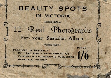
Postcard, Beauty spots in Victoria
... Looking out at Forest caves, 9. Lovers Walk - Cowes, 10. Forest Cave, 11. ...Looking out at Forest caves, 9. Lovers Walk - Cowes, 10. Forest Cave, 11. ...Tourist photographs of Phillip IslandHistoricalSmall black and white photos of scenes of Phillip Island including the jetty, beach, Nobbies and ferries. Enclosed in a beige paper envelope.Beauty spots in Victoria. 12 Real Photographs for your Snapshot Album. Produced in Australia by The Rose Stereograph Co. Price 1/6 1. The Pier, Cowes, 2. Front beach, Cowes, 3. Alvina & Genista at pier, $. Koala in tree, 5. beach near Nobbies, 6. The Nobbies, 7. The Pinnacles, 8. Looking out at Forest caves, 9. Lovers Walk - Cowes, 10. Forest Cave, 11. The road to back beach, 12. The beach & pier, Cowes.the nobbies, ferries, cowes jetty, forrest caves, phillip island, black & white postcard copy, photographs -
 Bendigo Historical Society Inc.
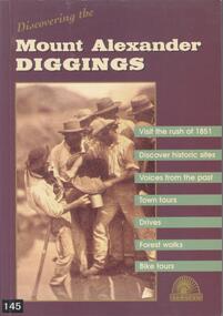
Book - BOOK: DISCOVERING THE MOUNT ALEXANDER DIGGINGS - MOUNT ALEXANDER DIGGINGS COMMITTEE, 1999
... Forest Creek in 1858. The book is a guide to the Mount Alexander goldfields with historical notes, sites to visit, suggested tours, drives and walks. ...Forest Creek in 1858. The book is a guide to the Mount Alexander goldfields with historical notes, sites to visit, suggested tours, drives and walks. ...BHS CollectionSoftcover book with purple cover and a detail from a sepia photograph of miners in Forest Creek in 1858. The book is a guide to the Mount Alexander goldfields with historical notes, sites to visit, suggested tours, drives and walks. The areas covered include Chewton, Castlemaine, Campbells Creek, Vaughan, Fryerstown Newstead and Maldon. Indigenous stories are also included.Mount Alexander Diggins Committeegoldfields, gold mining, mount alexander, castlemaine, campbells creek, maldon, indigenous stories -
 Bendigo Historical Society Inc.
Slide - Peter Ellis Collection, Kaweka Wildflower Reserve, Castlemaine, Lightning Hill Lookout Bendigo, One Tree Hill Lookout Tower Bendigo, Kamarooka Forest Area, c1970-1972
... walk along some of the tracks through the park follow the nature trail bird watch have a picnic at the picnic tables. RUSH Dam is a basic free camping area sits alongside Rush Dam in the Greater Bendigo National Park, featuring a single picnic table and wood fire barbecue. history bendigo peter ellis collection whipstick bendigo Bendigo State Forests kaweka wildflower reserve castlemaine one tree hill lookout bendigo lightning hill lookout bendigo kamarooka rush dam kamarooka Greater Bendigo National Park Peter Ellis Collection: Seventeen slides of Kaweka Wildflower Reserve, Castlemaine, Lightning Hill Lookout Bendigo, One Tree Hill Lookout Tower Bendigo. ...Kaweka Reserve is a a small reserve of approximately 8ha. The land was donated to the Castlemaine City to be a wildflower Reserve. A management committee was formed in 1966. The committee is still managing the park. Vicroads Edition 6: Map 59E2, 628 H4 Location. Turner St, Castlemaine. From the Castlemaine Post Office, drive north (towards Bendigo) and turn right along Turner Street to the park entrance. What to do: walk along some of the tracks through the park follow the nature trail bird watch have a picnic at the picnic tables. RUSH Dam is a basic free camping area sits alongside Rush Dam in the Greater Bendigo National Park, featuring a single picnic table and wood fire barbecue.Peter Ellis Collection: Seventeen slides of Kaweka Wildflower Reserve, Castlemaine, Lightning Hill Lookout Bendigo, One Tree Hill Lookout Tower Bendigo. Also the Rush Dam free camping area at Kamarooka. Also a slide of an unknown group having a meal or day out; perhaps also a working bee. In addition there are two slides of a house - location not specified; and a working bee clearing along a pipeline at Big Hill. Peter was a chemistry lecturer at the Bendigo Institute of technology.history, bendigo, peter ellis collection, whipstick bendigo, bendigo state forests, kaweka wildflower reserve castlemaine, one tree hill lookout bendigo, lightning hill lookout bendigo, kamarooka, rush dam kamarooka, greater bendigo national park -
 Bendigo Historical Society Inc.
Slide - Peter Ellis Collection, the Whipstick and Eucalyptus Oil Production, Solomon Gully Reserve Quarry Hill, Quarry Hill Golf Course Extensions Some history of the Whipstick, 1970-1990
... Forest Note for more information. Today, there are just two eucalypt distilleries operating in Bendigo. Most of the world’s eucalyptus oil is now produced overseas. SOLOMON GULLY CIRCUIT WALK...Forest Note for more information. Today, there are just two eucalypt distilleries operating in Bendigo. Most of the world’s eucalyptus oil is now produced overseas. SOLOMON GULLY CIRCUIT WALK ...When the numerous gold mines declined in production, the eucalyptus oil industry became an important source of work. The first eucalyptus oil producer in Bendigo was a chemist called Richard Sandner who operated a plant and refinery in Bridge Street from 1876. By 1900, many other distillers operated on the northern edge of Bendigo and in the Whipstick. In 1926, the Forest Commision established a eucalyptus distillery at Gunyah in Wellsford State Forest. See the Wellsford Forest Note for more information. Today, there are just two eucalypt distilleries operating in Bendigo. Most of the world’s eucalyptus oil is now produced overseas. SOLOMON GULLY CIRCUIT WALK - Solomon Gully Nature Conservation Reserve. Rangers say this is a great place to see heaps of Bendigo Waxflowers. A 1.5km, unsurfaced track. It is rough and steep in places, but suitable for families. Closed shoes with a good drip are recommend. The track is popular with families and runners. There is parking available off Burnside St (opposite Quarry Hill / Bendigo Lawn Cemetery).Peter Ellis Collection, t16 slides of the Whipstick and Eucalyptus Oil Production, Solomon Gully Reserve Quarry Hill, Quarry Hill Golf Course Extensions Some history of the Whipstick.history, bendigo, peter ellis collection, whipstick bendigo, bendigo state forests, eucalyptus oil, solomon gully reserve quarry hill bendigo, whipstick hotel shamrock, magetti's wallace reef wine hall, whipstick, frederick the great mine sebastian, quarry hill golf course -
 Otway Districts Historical Society
Photograph, Locomotive 8A and its mixed train at Colac Railway Station, c.1920, c.1920
... Otway Districts Historical Society Cliff Young Drive Beech Forest great-ocean-road Station facilities for the travelling public on the narrow gauge line at Colac Railway Station were non-existent for many years. Tickets were purchased from the broad gauge booking office and the travellers then had to walk with their luggage over the rough, potentially ankle-twisting, stone approaches, through the goods yard and wait in the open amongst the mud holes alongside the narrow gauge departure track. ...Station facilities for the travelling public on the narrow gauge line at Colac Railway Station were non-existent for many years. Tickets were purchased from the broad gauge booking office and the travellers then had to walk with their luggage over the rough, potentially ankle-twisting, stone approaches, through the goods yard and wait in the open amongst the mud holes alongside the narrow gauge departure track. In 1922 a footbridge was erected over the broad gauge lines, and a passenger shelter and small goods shed were built on the departure track.B/W. At Colac Railway Station, an locomotive 8A with five NQR wagons, an NM livestock wagon and a NBDBD combined passenger and brake van destined for Beech Forest, with either the driver or the fireman peering out of the engine, three youths standing at the front of the engine, and a group of people, including a woman, standing near the livestock wagon. A multi-storied shed and two houses are in the background. 179mm x 280mm picture.colac; railway; narrow gauge; na locomotive; -
 Otway Districts Historical Society
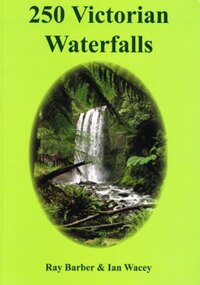
Book, Everbest Printing Company Ltd, 250 Victorian waterfalls, 2011
... Forest, compared to the often snow-covered Piemans Falls crashing down to the bottom of Bryce Gorge. This publication documents many of the more accessible waterfalls of Victoria, some for the first time, and many close to Melbourne. Ideal for bushwalkers, photographers, campers, or those who are interested in a healthy walk...Forest, compared to the often snow-covered Piemans Falls crashing down to the bottom of Bryce Gorge. This publication documents many of the more accessible waterfalls of Victoria, some for the first time, and many close to Melbourne. Ideal for bushwalkers, photographers, campers, or those who are interested in a healthy walk ...Victoria is not noted for its waterfalls but in fact there are many hundreds of beautiful waterfalls scattered throughout the state. Each waterfall is different from the next, some remarkably so. Consider the amazing Hopetoun Falls surrounded by lush rainforest ferns near Beech Forest, compared to the often snow-covered Piemans Falls crashing down to the bottom of Bryce Gorge. This publication documents many of the more accessible waterfalls of Victoria, some for the first time, and many close to Melbourne. Ideal for bushwalkers, photographers, campers, or those who are interested in a healthy walk or looking for somewhere to enjoy a pinic lunch. There is nothing better than doing so at the base of a majestic waterfall with the spray drifing across the rock face and the unique sound of the water tumbling into the drop pool below.250 Victorian waterfalls. Ray Barber. Ian Wacey. 1st ed. Ian Wacey; Eltham North (Vic); 2011. 320 p.; illus., map, references, index. Soft cover. ISBN 978 0 646 54331 4waterfalls; ray barber; ian wacey;, victoria; -
 Otway Districts Historical Society
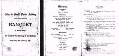
Photograph, Banquet, Opening of Colac-Beech Forest Railway, 1902, 26 Feb 1902
... On a typical Beech Forest wet day the train halted at the bottom of Gardner Hill for the opening party led by the State Governor, Sir George Sydenham Clarke, to walk up to the Ditchley Park Hotel for the official banquet in the adjoining hall. ...On a typical Beech Forest wet day the train halted at the bottom of Gardner Hill for the opening party led by the State Governor, Sir George Sydenham Clarke, to walk up to the Ditchley Park Hotel for the official banquet in the adjoining hall. ...The official opening of the Colac-Beech Forest railway took place on Wednesday, 26th February, 1902. On a typical Beech Forest wet day the train halted at the bottom of Gardner Hill for the opening party led by the State Governor, Sir George Sydenham Clarke, to walk up to the Ditchley Park Hotel for the official banquet in the adjoining hall. The menu of four courses plus coffee was assembed by the caterer, Chas. D. Straker. The toast list was led as usual by a toast to the King, followed by 18 toasts concluded by the Acting Commissioner of Railways.B/W. The menu and toast list at the opening of the Colac-Beech Forest Railway on Wednesday, 26th February, 1902, at Beech Forest. 128mm x 264mm actual -
Bendigo Historical Society Inc.
Document - CAROLS BY CANDLELIGHT, ROSALIND PARK, Dec, 1956
... Walk Delicatessen... Lee Jones & Son... George Miller Manchester House... Mathews Bros. Clothing Manchester... G A Johnson Pty. Ltd.... Fletcher's Royle ... Forest...Advertisements for: Hanro Quality Knitwear, Magnet Motors Jaguar & Simca Cars, J Frank Mamouney Carpets, Everys Book Shop, Ashmans' Mens Wear, Bouchers Boys Store clothing, A G Treloar Jeweler, Allan's Walk Delicatessen small goods, Lee Jones & Son grocers, George Miller Manchester House, Mathews Bros. Clothing Manchester linos curtains, G A Johnson Pty. Ltd., Fletcher's Royle Delicatessen, Forest...Advertisements for: Hanro Magnet Motors J Frank Mamouney Everys Ashmans' Bouchers A G Treloar Allan's Walk Delicatessen Lee Jones & Son George Miller Manchester House Mathews Bros. Clothing Manchester G A Johnson Pty. Ltd. Fletcher's Royle Forest ...Carols by Candlelight, Rosalind Park, Bendigo. Christmas Eve, 1956 at 8pm. Proceeds in aid Bendigo Old Folk's Welfare Society. Arranged by Bendigo and Eaglehawk Methodist Young Fellowship. Souvenir Program: 1/-. Compere - Rev. Trevor Byard, Choir - Methodist, Accompanists - 2 Pianos Miss Glenis Granger & Mr Fred Trewarne, Special Choral Items Leon Kinder, Saxophonist Barbara Mamouney, Contralto Coral Sheill, Soprano Clan McLeod Pipe Band. A special Christmas play by the Bendigo Christian Endeavour Union. Proceeds in aid of Bendigo Old Folks' Welfare Society. Advertisements for: Hanro Quality Knitwear, Magnet Motors Jaguar & Simca Cars, J Frank Mamouney Carpets, Everys Book Shop, Ashmans' Mens Wear, Bouchers Boys Store clothing, A G Treloar Jeweler, Allan's Walk Delicatessen small goods, Lee Jones & Son grocers, George Miller Manchester House, Mathews Bros. Clothing Manchester linos curtains, G A Johnson Pty. Ltd., Fletcher's Royle Delicatessen, Forest St. Fellowship, Bendigo & Eaglehawk Methodist Youth Fellowship.Cambridge Press, Bendigoevent, music, carols by candlelight, carols by candlelight, rosalind park, bendigo 1956. arranged by bendigo and eaglehawk methodist young fellowship. souvenir program: 1/-. compere - rev. trevor byard, choir - methodist, accompanists - 2 pianos miss glenis granger & mr fred trewarne, special choral items leon kinder, saxophonist barbara mamouney, contralto coral sheill, soprano clan mcleod pipe band. a special christmas play by the bendigo christian endeavour union. proceeds bendigo old folks' welfare society. advertisements for: hanro, magnet motors, j frank mamouney, everys, ashmans', bouchers, a g treloar, allan's walk delicatessen, lee jones & son, george miller manchester house, mathews bros. clothing manchester, g a johnson pty. ltd., fletcher's royle , forest st. fellowship, bendigo & eaglehawk methodist youth fellowship. -
 Ringwood and District Historical Society
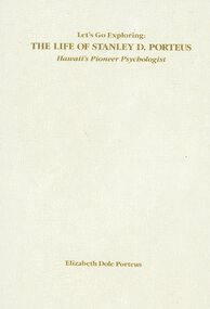
Book, Elizabeth Dole Porteus, Let's Go Exploring: The Life Of Stanley D. Porteus - Hawaii's Pioneer Psychologist, 1991
... He walked about 6 miles from the nearest railway station at Fernbank to find the school surrounded by virgin forest with only one dwelling in sight. ...He walked about 6 miles from the nearest railway station at Fernbank to find the school surrounded by virgin forest with only one dwelling in sight. ...White hard covered book. Biography by daughter-in-law of Stanley Porteus, pioneer of modern psychology and one-time resident of Ringwood, Victoria. SUMMARY NOTES. Stanley David Porteus was born in Box Hill, Victoria, Australia in 1883, the only son of a Methodist minister. Like other now large suburbs of Melbourne such as Canterbury, Mitcham and Ringwood, Box Hill was a mere village. Each was surrounded by bush. He grew up like most Australian boys with a love of sport and, although lightly built, did quite well at Australian Rules football and was above average at cricket. He became a schoolteacher with the Victorian Education Department. Promotion within the department depended on experience gained at teaching in tiny rural schools so he applied for such a position at Glenaladale, on the Dargo Road, some 35 miles north west of Bairnsdale. He walked about 6 miles from the nearest railway station at Fernbank to find the school surrounded by virgin forest with only one dwelling in sight. Attached to the school were lean-to rooms that were to be his residence for the next 2 ½ years. He was fascinated by the nearby Den of Nargun and Bull Creek, which joined the Mitchell River in a deep gorge containing a profusion of rainforest vegetation. While at Glenaladale, he met Frances Evans who became his wife. To seek promotion, he left Glenaladale and taught at Leneva and Benambra. While at the latter school, he learned of a position becoming available as superintendent of special schools in Melbourne. As the available means of transport, coach and horses to Bairnsdale, then by train to Melbourne, would not get him to Melbourne before the close of applications, he borrowed a bicycle and rode through the bush to his in-laws home at Lindenow and thus made it before the deadline. He was successful in his application and it set him on a course that lead to him becoming Australia's first Clinical Psychologist. His work, particularly, the development of the Porteus Maze Test, attracted the attention of American educators and he was offered an appointment for a year at Vineland Training School in New Jersey. On a stopover in Honolulu, he was impressed to the extent that he expressed a desire to work there. Not the least of its attractions was the mix of races that offered opportunities to study psychological differences, if any, between various races. His wish was to be granted unexpectedly as he was, in 1919, invited to Honolulu to set up a Psychological and Psychopathic Clinic at the University of Hawaii. From his home in the hills north of Honolulu, on December 7th 1941, he saw the Japanese attack on Pearl Harbour. He lived there until his death in about 1980. -
 Glenelg Shire Council Cultural Collection
Photograph - Photograph - Montage. Handover Ceremony of Portland Section of Great South West Walk to Department Conservation Forrest and Land, 13/04/1986
... Photographic Montage of handing over of Portland section of Great South West Walk, to the Department Conservation, Forests and Lands....Front: Bottom Right: Sticker, typed Handing over to Depatment,Conservation, Forests and Lands following inaugurul walk on City of Portland Section of the Great South West Walk. ...Photographic Montage of handing over of Portland section of Great South West Walk, to the Department Conservation, Forests and Lands. Photograph Photograph - Montage. ...Glenelg Shire Council RecordsPhotographic Montage of handing over of Portland section of Great South West Walk, to the Department Conservation, Forests and Lands.Front: Bottom Right: Sticker, typed Handing over to Depatment,Conservation, Forests and Lands following inaugurul walk on City of Portland Section of the Great South West Walk. (now a complete circuit) Signature in pen Grahame McDonald 13th April 1986. -
Federation University Historical Collection
Map, Otways Walks and Waterfalls Map, 2013, 06/2013
... Barker Library (top floor) Mount Helen goldfields colac, lorne, apollo bay, beech forest, forrest, barwon downs, deans march, winchelsea, gellibrand, lavers hill, port campbel, princetown, johanna, timboon, cobden, camperdown, swan marsh, simpson, birregurra, beeac, marengo, wye river, kennett river, skenes creek, peterborough< marriners falls, beauchamp falls, hopetoun falls, triplet falls, little aire falls, stevensons falls Tourist map of the Otways showing the townships of Colac, Lorne, Apollo Bay, Beech Forest, Forrest, Barwon Downs, Deans March, Winchelsea, Gellibrand, Lavers Hill, POrt Campbel, Princetown, Johanna, Timboon, Cobden, Camperdown, Swan Marsh, Simpson, Birregurra, Beeac, Marengo, Wye River, Kennett River, Skenes Creek, Peterborough Otways Walks and Waterfalls Map, 2013 Map ...Tourist map of the Otways showing the townships of Colac, Lorne, Apollo Bay, Beech Forest, Forrest, Barwon Downs, Deans March, Winchelsea, Gellibrand, Lavers Hill, POrt Campbel, Princetown, Johanna, Timboon, Cobden, Camperdown, Swan Marsh, Simpson, Birregurra, Beeac, Marengo, Wye River, Kennett River, Skenes Creek, Peterboroughcolac, lorne, apollo bay, beech forest, forrest, barwon downs, deans march, winchelsea, gellibrand, lavers hill, port campbel, princetown, johanna, timboon, cobden, camperdown, swan marsh, simpson, birregurra, beeac, marengo, wye river, kennett river, skenes creek, peterborough< marriners falls, beauchamp falls, hopetoun falls, triplet falls, little aire falls, stevensons falls -
 Mont De Lancey
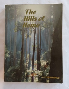
Book, Arthur Paul Wizenreid et al, The Hills of Home: A Bicentennial History of the Shire of Sherbrooke, 1988
... The forest offers popular hiking trails, including the walk to Sherbrooke Falls, and multiple picnic areas like Grants Picnic Ground. ...This 374-page work traces the history of the Shire of Sherbrooke in Victoria, Australia. It covers the region's development from before European colonisation up to the bicentennial year. Sherbrooke Forest is a prominent 800+ hectare section of the Dandenong Ranges National Park, located about 40 km east of Melbourne. Famous for its towering Mountain Ash trees and dense fern gullies, it is a premier location for spotting wild lyrebirds, wallabies, and cockatoos. The forest offers popular hiking trails, including the walk to Sherbrooke Falls, and multiple picnic areas like Grants Picnic Ground.This is a local history of the Shire of Sherbrooke in Victoria, Australia, documenting its development. The cover front has a beautiful green toned scene of the forest trees with the title printed at the top in pale green lettering outlined in black. The author is printed in yellow at the bottom. The title page lists the publishing details with Original pen and ink drawings by Jillienne Winzenried printed at the bottom. There is an Acknowledgements page, Foreword, Contents and Introduction. At the back, Chapter 18 is a Prologue, followed by three Appendices, Endnotes and an Index. Throughout the book are black and white photos as well as coloured ones, maps, illustrations, lists, advertisements. The back cover has a photograph with a black surround depicting a woman seated looking at autumn leaves. Pp. 374 non-fictionThis 374-page work traces the history of the Shire of Sherbrooke in Victoria, Australia. It covers the region's development from before European colonisation up to the bicentennial year. Sherbrooke Forest is a prominent 800+ hectare section of the Dandenong Ranges National Park, located about 40 km east of Melbourne. Famous for its towering Mountain Ash trees and dense fern gullies, it is a premier location for spotting wild lyrebirds, wallabies, and cockatoos. The forest offers popular hiking trails, including the walk to Sherbrooke Falls, and multiple picnic areas like Grants Picnic Ground. australian history, dandenong ranges - history, dandenong ranges - tourism and travel, tourism - victoria, sherbrooke forest - victoria -
 Marysville & District Historical Society
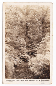
Postcard (item) - Black and white postcard, Rose Stereograph Company, Talbot Drive, Marysville, Vic. No. 5. Beech Grove, 1913-1967
... A black and white photograph which shows the track known as the Beeches Walk winding through a forest of trees and tree ferns.The Rose Series of postcards P. 2310. ...A black and white photograph which shows the track known as the Beeches Walk winding through a forest of trees and tree ferns.The Rose Series of postcards P. 2310. ...A postcard in a series produced by the Rose Stereograph Company in Victoria, Australia as a souvenir of Marysville.A black and white photograph taken along Lady Talbot Drive, Marysville, Victoria, of the area known as the Beech Grove. The Beeches Rainforest Walk is a loop that starts at Taggerty Cascades before winding through Myrtle Beech and Mountain Ash woodland and is one of the many walking tracks in and around Marysville. It is accessible from Lady Talbot Drive which is a 24 kilometer scenic rainforest car journey which passes a number of walks and waterfalls in the Yarra Ranges National Park. Lady Talbot Drive is named after Lady Sarah Elizabeth, the wife of Sir Reginald Talbot, who was the Governor of Victoria from 25th April, 1904 to 6th July 1908. This postcard was produced by the Rose Stereograph Company as a souvenir of Marysville.POST CARD The "Rose" Set/ De Luxe A Real Photograph/ Produced in Australia Published by the Rose Stereograph Co./ Armadale, Victoria. This is just to remind you of/ Marysville - I am spending the/ weekend up here & thoroughly/ enjoying it./ Love to all of you L. McIver All best honey + thanks for/ a lovely day E. + P. F.talbot drive, marysville, victoria, beech grove, p. 2310, rose series postcard, postcard, souvenir, beeches rainforest walk, sarah elizabeth talbot, sir reginald talbot, mountain ash, myrtle beech -
 Marysville & District Historical Society
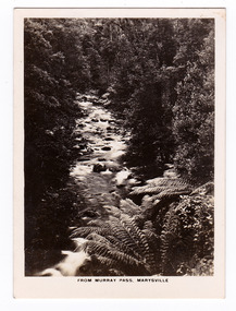
Photograph (item) - Black and white photograph, Rose Stereograph Company, From Murray Pass, Marysville, 1913-1967
... walks and waterfalls in the Yarra Ranges National Park. Lady Talbot Drive is named after Lady Sarah Elizabeth, the wife of Sir Reginald Talbot, who was the Governor of Victoria from 25th April, 1904 to 6th July 1908.The photograph was also used to produce the Rose Series postcard P. 2309. marysville victoria photograph taggerty river murray pass lady talbot forest drive p. 2309 rose series postcard souvenir rose stereograph company sir reginald talbot lady sarah elizabeth talbot An early black and white photograph of the Taggerty River from Murray Pass near Marysville, Victoria. ...An early black and white photograph of the Taggerty River from Murray Pass near Marysville, Victoria.An early black and white photograph of the Taggerty River from Murray Pass near Marysville, Victoria. Murray Pass is off the Lady Talbot Drive. Lady Talbot Drive a 24 kilometer scenic rainforest car journey which passes a number of walks and waterfalls in the Yarra Ranges National Park. Lady Talbot Drive is named after Lady Sarah Elizabeth, the wife of Sir Reginald Talbot, who was the Governor of Victoria from 25th April, 1904 to 6th July 1908.The photograph was also used to produce the Rose Series postcard P. 2309.marysville, victoria, photograph, taggerty river, murray pass, lady talbot forest drive, p. 2309, rose series postcard, souvenir, rose stereograph company, sir reginald talbot, lady sarah elizabeth talbot -
 Marysville & District Historical Society
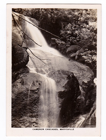
Photograph (item) - Black and white photograph, Rose Stereograph Company, Cameron Cascades, Marysville, 1913-1967
... walks and waterfalls in the Yarra Ranges National Park. Lady Talbot Drive is named after Lady Sarah Elizabeth, the wife of Sir Reginald Talbot, who was the Governor of Victoria from 25th April, 1904 to 6th July 1908. The photograph was also used to produce the Rose Series postcard P. 2313. marysville victoria photograph cameron cascades waterfalls cameron cascades track lady talbot forest drive p. 2313 rose series postcard souvenir rose stereograph company sir reginald talbot lady sarah elizabeth talbot An early black and white photograph of the Cameron Cascades Pass near Marysville, Victoria. ...An early black and white photograph of the Cameron Cascades near Marysville, Victoria.An early black and white photograph of the Cameron Cascades near Marysville, Victoria. The Cameron Cascades are off the Lady Talbot Drive. Lady Talbot Drive a 24 kilometer scenic rainforest car journey which passes a number of walks and waterfalls in the Yarra Ranges National Park. Lady Talbot Drive is named after Lady Sarah Elizabeth, the wife of Sir Reginald Talbot, who was the Governor of Victoria from 25th April, 1904 to 6th July 1908. The photograph was also used to produce the Rose Series postcard P. 2313.marysville, victoria, photograph, cameron cascades, waterfalls, cameron cascades track, lady talbot forest drive, p. 2313, rose series postcard, souvenir, rose stereograph company, sir reginald talbot, lady sarah elizabeth talbot -
 Marysville & District Historical Society
Postcard (item) - Black and white postcard, Rose Stereograph Company, At Murray Pass, Marysville, 1913-1967
... walks and waterfalls in the Yarra Ranges National Park. Lady Talbot Drive is named after Lady Sarah Elizabeth, the wife of Sir Reginald Talbot, who was the Governor of Victoria from 25th April, 1904 to 6th July 1908. This postcard was produced by the Rose Stereograph Company as a souvenir of Marysville. marysville victoria photograph taggerty river murray pass lady talbot forest drive southern cross series 2309 postcard souvenir lady talbot drive sir reginald talbot sarah elizabeth talbot SOUTHERN CROSS SERIES 2309/ COPYRIGHT/ AT MURRAY PASS, MARYSVILLE, VIC. ...A postcard in a series produced by the Rose Stereograph Company in Victoria, Australia as a souvenir of Marysville.An early black and white photograph of the Taggerty River from Murray Pass near Marysville, Victoria. Murray Pass is located on the Lady Talbot Drive. Lady Talbot Drive a 24 kilometer scenic rainforest car journey which passes a number of walks and waterfalls in the Yarra Ranges National Park. Lady Talbot Drive is named after Lady Sarah Elizabeth, the wife of Sir Reginald Talbot, who was the Governor of Victoria from 25th April, 1904 to 6th July 1908. This postcard was produced by the Rose Stereograph Company as a souvenir of Marysville.SOUTHERN CROSS SERIES 2309/ COPYRIGHT/ AT MURRAY PASS, MARYSVILLE, VIC. POST CARD. Correspondence Addressmarysville, victoria, photograph, taggerty river, murray pass, lady talbot forest drive, southern cross series, 2309, postcard, souvenir, lady talbot drive, sir reginald talbot, sarah elizabeth talbot -
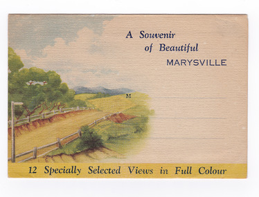
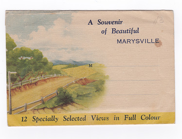 Marysville & District Historical Society
Postcard (item) - Colour photographs, Nucolorvue Productions, A Souvenir of Beautiful Marysville-12 Specially Selected Views in Full Colour, 1950's
... walks amongst the tall/ timber, or through the fern glades. Apart from many excellent walking trips, Marysville district/ offers ample scope for car trips to the nearby Cumberland Forest,/ Buxton, Narbethong, or the Taggerty Valley. ...walks amongst the tall/ timber, or through the fern glades. Apart from many excellent walking trips, Marysville district/ offers ample scope for car trips to the nearby Cumberland Forest,/ Buxton, Narbethong, or the Taggerty Valley. ...An envelope of 12 colour photographs of attractions in and around Marysville in Victoria.An envelope of 12 colour photographs of attractions in and around Marysville in Victoria. These photographs were produced by Nucolorvue Productions in Mentone, Victoria.A Souvenir of Beautiful MARYSVILLE 12 Specially Selected Views in Full Colour Marysville, Victoria, Australia Marysville, 60 miles from Melbourne, is one of nature's/ lovely beauty spots. The invigorating mountain air helps the/ visitor to enjoy the many delightful walks amongst the tall/ timber, or through the fern glades. Apart from many excellent walking trips, Marysville district/ offers ample scope for car trips to the nearby Cumberland Forest,/ Buxton, Narbethong, or the Taggerty Valley. Skiers find Lake Mountain an attraction in the winter, whilst/ the hiker finds ample for his needs in the numerous mountain/ areas. Huge Eucalypt trees, revealing their ramrod straightness up/ to 300 feet in height, are a fitting background to the many/ beautiful creeks and waterfalls. PUBLISHED BY NUCOLORVUE PRODUCTIONS, MENTONE, VICTORIA.nicholl's lookout (image 1), eildon weir (image 2), road to lake mountain (image 3), foot of steavenson falls (image 4), steavenson falls (image 5), bush scene near marysville (image 6), bush track marysville (image 7), bridge and chalet and crossways marysville (image 8), log cabin at marysville (image 9), black spur (image 10), taggerty river (image 11), highest known hardwood tree (image 12), marysville, victoria, nucolorvue productions, postcard, souvenir -
 Marysville & District Historical Society
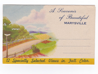
Postcard (item) - Colour photographs, Nucolorvue Productions, A Souvenir of Beautiful Marysville-12 Specially Selected Views in Full Colour, Unknown
... walks amongst the tall/ timber, or through the fern glades. Apart from many excellent walking trips, Marysville district/ offers ample scope for car trips to the nearby Cumberland Forest,/ Buxton, Narbethong, or the Taggerty Valley. ...walks amongst the tall/ timber, or through the fern glades. Apart from many excellent walking trips, Marysville district/ offers ample scope for car trips to the nearby Cumberland Forest,/ Buxton, Narbethong, or the Taggerty Valley. ...An envelope of 12 colour photographs of attractions in and around Marysville in Victoria.An envelope of 12 colour photographs of attractions in and around Marysville in Victoria. These photographs were produced by Nucolorvue Productions in Mentone, Victoria.A Souvenir of Beautiful MARYSVILLE 12 Specially Selected Views in Full Colour Marysville, Victoria, Australia Marysville, 60 miles from Melbourne, is one of nature's/ lovely beauty spots. The invigorating mountain air helps the/ visitor to enjoy the many delightful walks amongst the tall/ timber, or through the fern glades. Apart from many excellent walking trips, Marysville district/ offers ample scope for car trips to the nearby Cumberland Forest,/ Buxton, Narbethong, or the Taggerty Valley. Skiers find Lake Mountain an attraction in the winter, whilst/ the hiker finds ample for his needs in the numerous mountain/ areas. Huge Eucalypt trees, revealing their ramrod straightness up/ to 300 feet in height, are a fitting background to the many/ beautiful creeks and waterfalls. PUBLISHED BY NUCOLORVUE PRODUCTIONS, MENTONE, VICTORIA.nicholl's lookout (image 1), eildon weir (image 2), road to lake mountain (image 3), foot of steavenson falls (image 4), steavenson falls (image 5), bush scene near marysville (image 6), bush track marysville (image 7), bridge and chalet and crossways marysville (image 8), log cabin at marysville (image 9), black spur (image 10), taggerty river (image 11), highest known hardwood tree (image 12), marysville, victoria, nucolorvue productions, postcard, souvenir -
 Marysville & District Historical Society
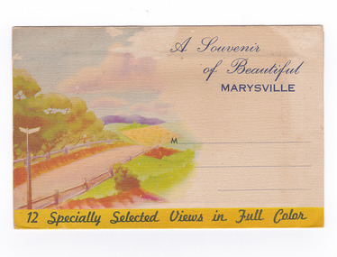
Postcard (item) - Colour photographs, Nucolorvue Productions, A Souvenir of Beautiful Marysville-12 Specially Selected Views in Full Colour, Unknown
... walks amongst the tall/ timber, or through the fern glades. Apart from many excellent walking trips, Marysville district/ offers ample scope for car trips to the nearby Cumberland Forest,/ Buxton, Narbethong, or the Taggerty Valley. ...walks amongst the tall/ timber, or through the fern glades. Apart from many excellent walking trips, Marysville district/ offers ample scope for car trips to the nearby Cumberland Forest,/ Buxton, Narbethong, or the Taggerty Valley. ...An envelope of 12 colour photographs of attractions in and around Marysville in Victoria.An envelope of 12 colour photographs of attractions in and around Marysville in Victoria. These photographs were produced by Nucolorvue Productions in Mentone, Victoria.A Souvenir of Beautiful MARYSVILLE 12 Specially Selected Views in Full Colour Marysville, Victoria, Australia Marysville, 60 miles from Melbourne, is one of nature's/ lovely beauty spots. The invigorating mountain air helps the/ visitor to enjoy the many delightful walks amongst the tall/ timber, or through the fern glades. Apart from many excellent walking trips, Marysville district/ offers ample scope for car trips to the nearby Cumberland Forest,/ Buxton, Narbethong, or the Taggerty Valley. Skiers find Lake Mountain an attraction in the winter, whilst/ the hiker finds ample for his needs in the numerous mountain/ areas. Huge Eucalypt trees, revealing their ramrod straightness up/ to 300 feet in height, are a fitting background to the many/ beautiful creeks and waterfalls. PUBLISHED BY NUCOLORVUE PRODUCTIONS, MENTONE, VICTORIA.nicholl's lookout (image 1), eildon weir (image 2), road to lake mountain (image 3), foot of steavenson falls (image 4), steavenson falls (image 5), bush scene near marysville (image 6), bush track marysville (image 7), bridge and chalet and crossways marysville (image 8), log cabin at marysville (image 9), black spur (image 10), taggerty river (image 11), highest known hardwood tree (image 12), marysville, victoria, nucolorvue productions, postcard, souvenir -
 Marysville & District Historical Society
Postcard (item) - Colour photographs, Nucolorvue Productions, A Souvenir of Beautiful Marysville-12 Specially Selected Views in Full Colour, Unknown
... walks amongst the tall/ timber, or through the fern glades. Apart from many excellent walking trips, Marysville district/ offers ample scope for car trips to the nearby Cumberland Forest,/ Buxton, Narbethong, or the Taggerty Valley. ...walks amongst the tall/ timber, or through the fern glades. Apart from many excellent walking trips, Marysville district/ offers ample scope for car trips to the nearby Cumberland Forest,/ Buxton, Narbethong, or the Taggerty Valley. ...An envelope of 12 colour photographs of attractions in and around Marysville in Victoria.An envelope of 12 colour photographs of attractions in and around Marysville in Victoria. These photographs were produced by Nucolorvue Productions in Mentone, Victoria.A Souvenir of Beautiful MARYSVILLE 12 Specially Selected Views in Full Colour Marysville, Victoria, Australia Marysville, 60 miles from Melbourne, is one of nature's/ lovely beauty spots. The invigorating mountain air helps the/ visitor to enjoy the many delightful walks amongst the tall/ timber, or through the fern glades. Apart from many excellent walking trips, Marysville district/ offers ample scope for car trips to the nearby Cumberland Forest,/ Buxton, Narbethong, or the Taggerty Valley. Skiers find Lake Mountain an attraction in the winter, whilst/ the hiker finds ample for his needs in the numerous mountain/ areas. Huge Eucalypt trees, revealing their ramrod straightness up/ to 300 feet in height, are a fitting background to the many/ beautiful creeks and waterfalls. PUBLISHED BY NUCOLORVUE PRODUCTIONS, MENTONE, VICTORIA.nicholl's lookout (image 1), eildon weir (image 2), road to lake mountain (image 3), foot of steavenson falls (image 4), steavenson falls (image 5), bush scene near marysville (image 6), bush track marysville (image 7), bridge and chalet and crossways marysville (image 8), log cabin at marysville (image 9), black spur (image 10), taggerty river (image 11), highest known hardwood tree (image 12), marysville, victoria, nucolorvue productions, postcard, souvenir -
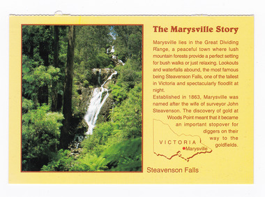 Marysville & District Historical Society
Postcard (item) - Colour postcard, Neil Cutts, The Marysville Story-Steavenson Falls, Pre 2009
... The Marysville Story/ Marysville lies in the Great Dividing/ Range, a peaceful town where lush/ mountain forests provide a perfect setting/ for bush walks or just relaxing. ...Rose Series Postcard No. 3530. marysville steavenson falls victoria postcard souvenir rose stereograph co 3530 john steavenson The Marysville Story/ Marysville lies in the Great Dividing/ Range, a peaceful town where lush/ mountain forests provide a perfect setting/ for bush walks or just relaxing. ...A postcard in a series produced by the Rose Stereograph Company in Victoria, Australia as a souvenir of Marysville.A colour photograph of Steavenson Falls in Marysville, Victoria. The Steavenson Falls is named after the Victorian Assistant Commissioner of Roads and Bridges, John Steavenson, who arrived in Victoria in the early 1860s. At 84 metres high, Steavenson Falls is Victoria's tallest cascading waterfall. The falls are split into roughly five cascades, with the last of these plunging into a small, picturesque rock pool. Rose Series Postcard No. 3530. The Marysville Story/ Marysville lies in the Great Dividing/ Range, a peaceful town where lush/ mountain forests provide a perfect setting/ for bush walks or just relaxing. Lookouts/ and waterfalls abound, the most famous/ being Steavenson Falls, one of the tallest/ in Victoria and spectacularly floodlit at/ night./ Established in 1863, Marysville was/ named after the wife of surveyor John/ Steavenson. The discovery of gold at/ Woods Point meant that it became/ an important stopover for/ diggers on their/ way to the/ goldfields. Steavenson Falls POST CARD The "Rose" Series/ De Luxe Proudly Printed in/ Australia Since 1880 AFFIX/ STAMP/HERE/ Rose Series/ Post Card No./ 3530 ADDRESS/ POSTCODE the MARYSVILLE STORY & Steavenson Falls/ MARYSVILLE, VICTORIA, AUSTRALIA/ Photo Neil Cutts Copyright Rose Stereograph Co., Glen Waverley, Victoria (03) 9560 7772marysville, steavenson falls, victoria, postcard, souvenir, rose stereograph co, 3530, john steavenson -
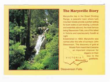 Marysville & District Historical Society
Postcard (item) - Colour postcard, Neil Cutts, The Marysville Story-Steavenson Falls, Pre 2009
... The Marysville Story/ Marysville lies in the Great Dividing/ Range, a peaceful town where lush/ mountain forests provide a perfect setting/ for bush walks or just relaxing. ...The Rose Series postcard No. 3530. marysville steavenson falls victoria postcard souvenir rose stereograph co 3530 john steavenson The Marysville Story/ Marysville lies in the Great Dividing/ Range, a peaceful town where lush/ mountain forests provide a perfect setting/ for bush walks or just relaxing. ...A postcard in a series produced by the Rose Stereograph Company in Victoria, Australia as a souvenir of Marysville.A colour photograph of Steavenson Falls in Marysville, Victoria. The Steavenson Falls is named after the Victorian Assistant Commissioner of Roads and Bridges, John Steavenson, who arrived in Victoria in the early 1860s. At 84 metres high, Steavenson Falls is Victoria's tallest cascading waterfall. The falls are split into roughly five cascades, with the last of these plunging into a small, picturesque rock pool. The Rose Series postcard No. 3530. The Marysville Story/ Marysville lies in the Great Dividing/ Range, a peaceful town where lush/ mountain forests provide a perfect setting/ for bush walks or just relaxing. Lookouts/ and waterfalls abound, the most famous/ being Steavenson Falls, one of the tallest/ in Victoria and spectacularly floodlit at/ night./ Established in 1863, Marysville was/ named after the wife of surveyor John/ Steavenson. The discovery of gold at/ Woods Point meant that it became/ an important stopover for/ diggers on their/ way to the/ goldfields. Steavenson Falls POST CARD The "Rose" Series/ De Luxe Proudly Printed in/ Australia Since 1880 AFFIX/ STAMP/HERE/ Rose Series/ Post Card No./ 3530 ADDRESS/ POSTCODE the MARYSVILLE STORY & Steavenson Falls/ MARYSVILLE, VICTORIA, AUSTRALIA/ Photo Neil Cutts Copyright Rose Stereograph Co., Glen Waverley, Victoria (03) 9560 7772marysville, steavenson falls, victoria, postcard, souvenir, rose stereograph co, 3530, john steavenson