Showing 31 items matching "fyans valley"
-
 Stawell Historical Society Inc
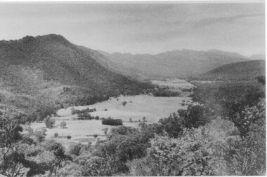
Photograph, Fyans Valley in Halls Gap -- Before lake Belfield was constructed
... Fyans Valley in Halls Gap -- Before lake Belfield was constructed...Fyans Valley. Halls Gap. Before lake Belfield constructed....Stawell Fyans Valley in Halls Gap -- Before lake Belfield was constructed Photograph ...Fyans Valley. Halls Gap. Before lake Belfield constructed.stawell -
 Halls Gap & Grampians Historical Society
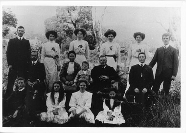
Photograph, C 1910
... George Warren family on their Fyans Valley property George Warren (father) and son Frank seated left died within a week of each other during war at Gallipolli....Photograph of Warren family on property at Fyans Valley ...Halls Gap & Grampians Historical Society Centennial Hall 117-119 Grampians Road Halls Gap grampians George Warren family on their Fyans Valley property George Warren (father) and son Frank seated left died within a week of each other during war at Gallipolli. people warren myrtlebank AGFA This paper manufactured by Kodak Photograph of Warren family on property at Fyans Valley Photograph ...George Warren family on their Fyans Valley property George Warren (father) and son Frank seated left died within a week of each other during war at Gallipolli.Photograph of Warren family on property at Fyans Valley AGFA This paper manufactured by Kodakpeople, warren, myrtlebank -
 Halls Gap & Grampians Historical Society
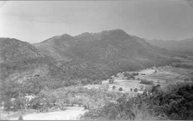
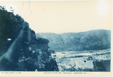
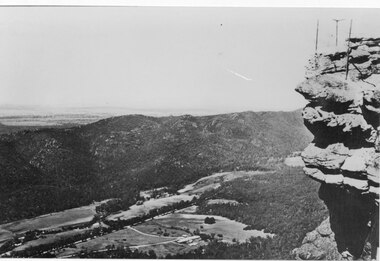
Photograph
... ...Fyans Valley...Photo is of Fyans Valley with Hotel Bellfield in the valley. ...Halls Gap & Grampians Historical Society Centennial Hall 117-119 Grampians Road Halls Gap grampians Photo is of Fyans Valley with Hotel Bellfield in the valley. ...Photo is of Fyans Valley with Hotel Bellfield in the valley. Photo is taken from Bellfield Peak. c1940sA rocky outcrop on far left of photo. a cleared valley with buildings and roads in foreground, flanked by a mountain range.THE ROSE SERIES. P 1695 BELLFIELD PEAK AND "BELLFIELD," GRAMPIANS, VIC scenery, fyans valley -
 Halls Gap & Grampians Historical Society
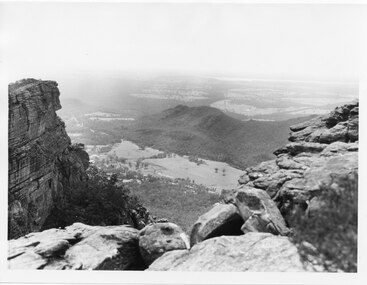
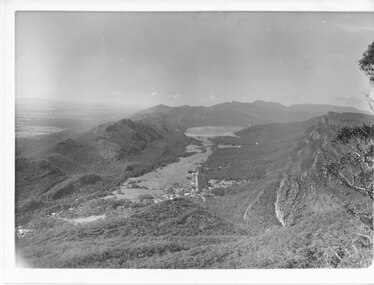
Photograph, C 1960s
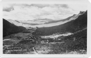
... ...Fyans Valley...The valley is known as Fyans Valley and the township of Halls Gap. Photo is typical of those taken by the Forestry Commission (Vic) during the 1960s....SCENERY Fyans Valley Photo shows two rocky outcrops in the foreground framing a valley in the distance below. ...The valley is known as Fyans Valley and the township of Halls Gap. Photo is typical of those taken by the Forestry Commission (Vic) during the 1960s.Photo shows two rocky outcrops in the foreground framing a valley in the distance below. A partial view of a mountain range flanks the valley. Plains of trees and open fields, and also a lake, can be seen beyond the mountain range. Within the valley in the middle of the photo buildings, roads and cleared land can be seen.scenery, fyans valley -
 Halls Gap & Grampians Historical Society
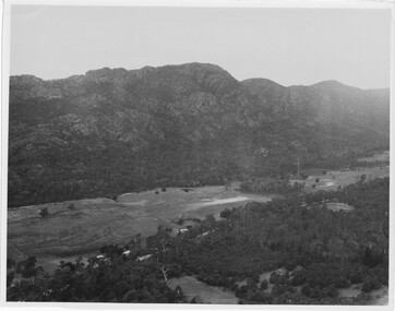
Photograph, C 1940 -50s
... ...Fyans Valley...Valley is now known as Fyans Valley but in the 1840-50s it was called Lady Mary's Vale. ...See p. 111 of 'Victoria's Wonderland' for historical information. SCENERY Fyans Valley A valley with a cleared area stretching along the valley floor. ...Valley is now known as Fyans Valley but in the 1840-50s it was called Lady Mary's Vale. See p. 111 of 'Victoria's Wonderland' for historical information.A valley with a cleared area stretching along the valley floor. A mountain range runs along the left and into the distance of the photograph. a rocky outcrop, bushes and trees appear in the front and right of the photo. c 1940-1950sscenery, fyans valley -
 Halls Gap & Grampians Historical Society
Photograph - B/W, C 1950s (?)
... ...Fyans Valley...Photograph is of Fyans Valley taken from Bellfield Peak. The mountain range across the centre of the scene runs north to south. ...The main road running through the middle of the valley is Grampians Road. SCENERY Fyans Valley A rocky outcrop, far right, with metal fence and posts. ...Photograph is of Fyans Valley taken from Bellfield Peak. The mountain range across the centre of the scene runs north to south. The large dwelling centre-front is Bellfield Hotel, which was destroyed by fire in the 1960s. The main road running through the middle of the valley is Grampians Road.A rocky outcrop, far right, with metal fence and posts. View of a valley with cleared land, roads and buildings in foreground. Further cleared land can be seen beyond a mountain range that is in the centre of the photograph.scenery, fyans valley -
 Halls Gap & Grampians Historical Society
Photograph - B/W
... ...Fyans Valley...Photo has been taken from Boroka Peak/lookout, of the Fyans Valley and the township of Halls Gap. The Grampians/Dunkeld Road can be seen running North/South along the right edge of the valley and Lake Bellfield is the water at the end of the valley. ...Photo is typical of those taken by Forrests Commission at the time SCENERY Fyans Valley no.42 a photo of a valley, mostly cleared, flanked by two mountain ranges. ...Photo has been taken from Boroka Peak/lookout, of the Fyans Valley and the township of Halls Gap. The Grampians/Dunkeld Road can be seen running North/South along the right edge of the valley and Lake Bellfield is the water at the end of the valley. Photo is typical of those taken by Forrests Commission at the timea photo of a valley, mostly cleared, flanked by two mountain ranges. A large body of water can be seen at the far end of the valley (middle of photo). Buildings and roads visible in the valley. Plains can be seen beyond the far mountain range on the left side of the scene.no.42scenery, fyans valley -
 Halls Gap & Grampians Historical Society
Photograph
... ...Fyans Valley...Photo depicts Fyans Valley. The road is The Grampians/ Dunkeld Road, leading to Dunkeld towards the right or Halls Gap travelling towards the left. ...Photo is typical of those taken by Forests Commission of Victoria in the 1960s SCENERY Fyans Valley Photo shows a mountain range in the background with a valley. ...Photo depicts Fyans Valley. The road is The Grampians/ Dunkeld Road, leading to Dunkeld towards the right or Halls Gap travelling towards the left. Fyans Creek is visible in parts at the foot of the range (middle of Photo). Photo appears to have been taken from Bellfield Pk area. Photo is typical of those taken by Forests Commission of Victoria in the 1960sPhoto shows a mountain range in the background with a valley. The Valley has a band of a mostly cleared grassy section (middle of photo) with a fairly dense treed area in the foreground. A road and some buildings can be seen where the cleared land meets the treed area.scenery, fyans valley -
 Halls Gap & Grampians Historical Society
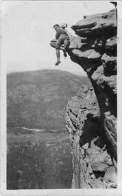
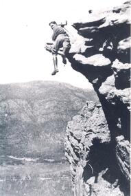
Postcard - Sepia
... Photo shows photographer Gilbert Rogers hanging from rock, overlooking Fyans Valley...Kodak Australia Photo shows photographer Gilbert Rogers hanging from rock, overlooking Fyans Valley Postcard Sepia ...A transparency (slide) copy of this photo is held in the slide box (slide no. 176)Photo shows photographer Gilbert Rogers hanging from rock, overlooking Fyans ValleyPost card, correspondence, address only. Kodak Australiapeople, gilbert rogers, scenery, lookouts -
 Halls Gap & Grampians Historical Society
Postcard - B/W
... ...Fyans Valley...This postcard is one of a series. SCENERY Fyans Valley Depicts as valley with mountains on both sides. ...Photo on card was taken by Gilbert Rogers, a photographer and tour guide during the 1930s. This postcard is one of a series.Depicts as valley with mountains on both sides. Cleared land can be seen on either side of a road which runs through the valley. Buildings are also visible in middle area. View is running south-west.scenery, fyans valley -
 Halls Gap & Grampians Historical Society
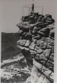
Photograph - Transparency, C 1920s
... William Range is in the background, Fyans Valley/Halls Gap is visible below....William Range is in the background, Fyans Valley/Halls Gap is visible below. Photograph Transparency ...Gilbert Francis Rogers (1884-1950). Born In Gawler,S.A. came to Halls Gap as a photographer. He soon became a guide as well as a photographer, often setting up his camera and then posing in the most unusual positionsMan with wearing boots with photographic equipment set up ,balancing on a ridge of a mountain range. Mt. William Range is in the background, Fyans Valley/Halls Gap is visible below.people, gilbert rogers -
 Halls Gap & Grampians Historical Society
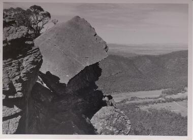
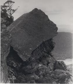
Photograph - B/W, C 1960s
... Photo shows large slab of rock with other rock outcrops. The Fyans Valley is below with the Mt. William range behind it. ...Halls Gap & Grampians Historical Society Centennial Hall 117-119 Grampians Road Halls Gap grampians Slab of rock is known as the The Fallen Giant SCENERY Wonderland Range Photo shows large slab of rock with other rock outcrops. The Fyans Valley is below with the Mt. William range behind it. ...Slab of rock is known as the The Fallen GiantPhoto shows large slab of rock with other rock outcrops. The Fyans Valley is below with the Mt. William range behind it. Roads traverse the valley. Some buildings can be seen.scenery, wonderland range -
 Halls Gap & Grampians Historical Society
Photograph - B/W
... Photo shows large slab of rock with other rock outcrops. The Fyans Valley is below with Mt.William range behind it. ...SCENERY Wonderland Range Photo shows large slab of rock with other rock outcrops. The Fyans Valley is below with Mt.William range behind it. ...Slab of rock is known as ' Fallen Giant'.Photo shows large slab of rock with other rock outcrops. The Fyans Valley is below with Mt.William range behind it. Large rock appears to be in shadow. A lone tree is perched on a rock behind.scenery, wonderland range -
 Halls Gap & Grampians Historical Society
Photograph - B/W, C 1960s
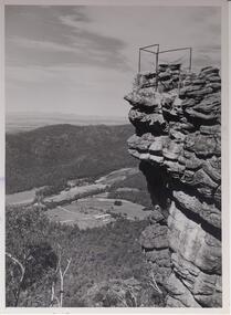
... Valley is the Fyans Valley....Valley is the Fyans Valley. SCENERY Lookouts On back notes "bellfield' but neither Bellfield Peak or Bellfield lookout can be seen. ...Lookout is known as 'The Pinnacle'. Valley is the Fyans Valley.Photo shows rocky outcrop surrounded by a wire fence and overlooking a valley with roads,some cleared areas and buildings. The Mt. William range can be seen middle left in the photo.On back notes "bellfield' but neither Bellfield Peak or Bellfield lookout can be seen.scenery, lookouts -
 Halls Gap & Grampians Historical Society
Photograph - B/W
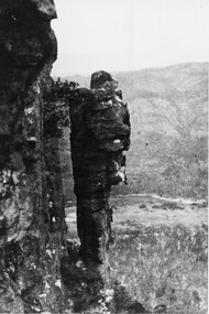
... The valley could be Fyans Valley....The valley could be Fyans Valley. SCENERY Grampians Ranges "the Idol" written on the back in blue pen. ...The pinnacle was called "The Idol". The valley could be Fyans Valley.The photo shows a free-standing pinnacle in front of a cliff edge (on the left). A bush/young tree is growing out from the cliff face near the top of the pinnacle. There is a valley and another range in the background."the Idol" written on the back in blue pen.scenery, grampians ranges -
 Halls Gap & Grampians Historical Society
Photograph - B/W
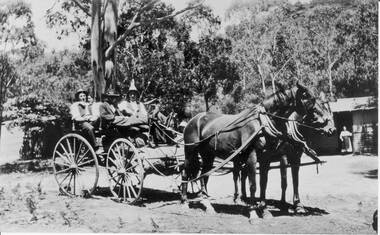
... Cottage could be Gray's cottage, situated in the Fyans valley....Halls Gap & Grampians Historical Society Centennial Hall 117-119 Grampians Road Halls Gap grampians Cottage could be Gray's cottage, situated in the Fyans valley. PEOPLEBUILDINGS Photo showing 2 horses hitched to a carriage in which there are 4 people, a man and a woman in the front and a man and a woman in the back. ...Cottage could be Gray's cottage, situated in the Fyans valley.Photo showing 2 horses hitched to a carriage in which there are 4 people, a man and a woman in the front and a man and a woman in the back. Another woman is standing inthe doorway of a cottage in the background.peoplebuildings -
 Halls Gap & Grampians Historical Society
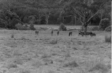
Photograph - Coloured, C 1980s
... Photo is located on Fyans Valley floor below Bellfield dam,...Halls Gap & Grampians Historical Society Centennial Hall 117-119 Grampians Road Halls Gap grampians Photo is located on Fyans Valley floor below Bellfield dam, NATURAL HISTORY Feral animals Fujicolor paper Photo is of nine deer in a grassy paddock with bushland at the rear. ...Photo is located on Fyans Valley floor below Bellfield dam,Photo is of nine deer in a grassy paddock with bushland at the rear. A large gumtree stands middle foreground. A dead gumtree stands in the background,Fujicolor papernatural history, feral animals -
 Halls Gap & Grampians Historical Society
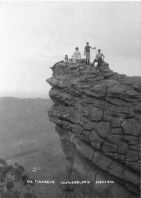
Photograph - B/W
... The valley below is the Fyans Valley....The valley below is the Fyans Valley. SCENERY Wonderland Range The Pinnacle Wonderland Grampians Three men and a woman laying, sitting and standing on top of a high rocky outcrop. ...Photograph is taken at the Pinnacle in the Wonderland Range. The valley below is the Fyans Valley.Three men and a woman laying, sitting and standing on top of a high rocky outcrop. The woman and two men wear hats and the man standing is holding a stick. A mountain range can be seen opposite them with a valley far below, between the two ranges. A group of buildings can be seen in the valley. The style of dress worn by the people suggests early 1900s.The Pinnacle Wonderland Grampiansscenery, wonderland range -
 Halls Gap & Grampians Historical Society
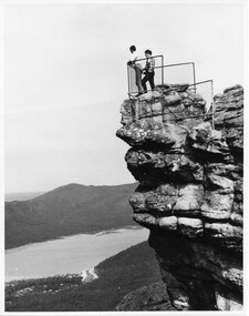
Photograph - B/W
... The two men are standing at The Pinnacle Lookout, overlooking Bellfield Reservoir in the Fyans Valley...Halls Gap & Grampians Historical Society Centennial Hall 117-119 Grampians Road Halls Gap grampians The two men are standing at The Pinnacle Lookout, overlooking Bellfield Reservoir in the Fyans Valley SCENERY Lookouts Two men standing behind cyclone wire three panel fence. ...The two men are standing at The Pinnacle Lookout, overlooking Bellfield Reservoir in the Fyans ValleyTwo men standing behind cyclone wire three panel fence. Man on left is wearing a white shirt and long pants, the other in a checked shirt and long dark pants. They are on top of a large rocky outcrop overlooking a body of water and another mountain range scenery, lookouts -
 Halls Gap & Grampians Historical Society
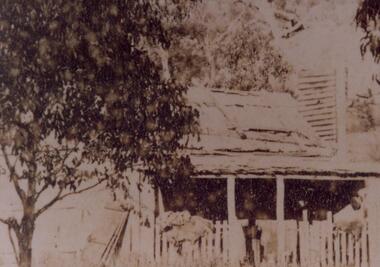
Photograph - Sepia, c 1876
... The cottage was situated below Mackey's Peak in the Fyans Valley. See p.77 Victoria's Wonderland....The cottage was situated below Mackey's Peak in the Fyans Valley. See p.77 Victoria's Wonderland. BUILDINGS Houses Photo shows old house with verandah enclosed with pickets. ...Cottage is said to be that of Foulkes family. The cottage was situated below Mackey's Peak in the Fyans Valley. See p.77 Victoria's Wonderland.Photo shows old house with verandah enclosed with pickets. Two gum trees can be seen either side of houses. Vegetation, either a garden or grass is growing in front of verandah. An old door or doors are leaning against left side of house.buildings, houses -
 Halls Gap & Grampians Historical Society
Photograph - B/W
... The Pinnacle Lookout with Fyans Valley below. Bellfield Hotel is visible in the lower left of the picture, cleared land is apparent in the middle of the picture....Halls Gap & Grampians Historical Society Centennial Hall 117-119 Grampians Road Halls Gap grampians The Pinnacle Lookout with Fyans Valley below. Bellfield Hotel is visible in the lower left of the picture, cleared land is apparent in the middle of the picture. ...The Pinnacle Lookout with Fyans Valley below. Bellfield Hotel is visible in the lower left of the picture, cleared land is apparent in the middle of the picture.Man standing at a lookout on a rocky outcrop overlooking a valley. Guide rails surround part of the outcop. A mountain range is opposite.scenery, lookouts -
 Halls Gap & Grampians Historical Society
Photograph - B/W, C 1876
... It was situated below Mackey's peak in the Fyans Valley. For further information see p. 77 of "Victoria's Wonderland"....It was situated below Mackey's peak in the Fyans Valley. For further information see p. 77 of "Victoria's Wonderland". ...This cottage is said to have belonged to the Foulkes family. It was situated below Mackey's peak in the Fyans Valley. For further information see p. 77 of "Victoria's Wonderland".The photo shows a timber house and outbuilding set among bush below a line of cliffs. There is a spoked wheeled cart standing to the right of the house. The buildings are in the foreground at the lower edge of the photo.buildings, houses -
 Halls Gap & Grampians Historical Society
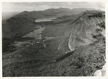
Photograph - B/W
... The photo is of the Fyans Valley, taken from Chatauqua Peak. Lake Bellfield and Mount William can be seen in the background. ...Halls Gap & Grampians Historical Society Centennial Hall 117-119 Grampians Road Halls Gap grampians The photo is of the Fyans Valley, taken from Chatauqua Peak. Lake Bellfield and Mount William can be seen in the background. ...The photo is of the Fyans Valley, taken from Chatauqua Peak. Lake Bellfield and Mount William can be seen in the background. The photo belonged to the Forestry Commission Victoria.A photo of a valley between mountain ranges. A lake can be seen in the background. A road runs through the middle of the valley with houses on both sides."Fyans Vaslley from Chataqua Peak. Incl L. Bellfield & Halls Gap. photo belongs to F.C.V. Stawell. Return to V. Young, Horsham" written on back in green pencil. The "Chatauqua Peak" has been overwritten in black-lead pencil. "LC.71" is also written on the back in black-lead pencil.scenery, grampians ranges -
 Halls Gap & Grampians Historical Society
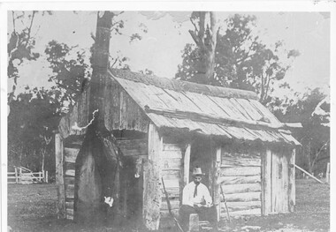
Photograph - B/W, c 1850s
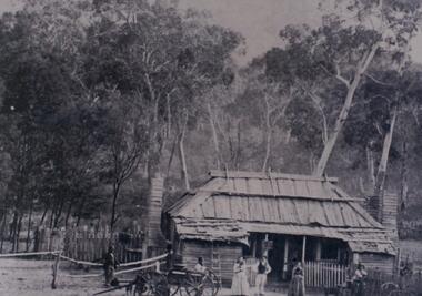
... This windowless bark hut would have been used by stockmen who looked after sheep and cattle in the Fyans Valley. This hut was situated at the site later named the Borough Huts. ...Halls Gap & Grampians Historical Society Centennial Hall 117-119 Grampians Road Halls Gap grampians This windowless bark hut would have been used by stockmen who looked after sheep and cattle in the Fyans Valley. This hut was situated at the site later named the Borough Huts. ...This windowless bark hut would have been used by stockmen who looked after sheep and cattle in the Fyans Valley. This hut was situated at the site later named the Borough Huts. See p8 Bridging the Gap Photo shows a man sitting outside a wooden slab hut. The hut has a tin flashing along top roof line. Man is wearing a hat and tie. A gun is leaning up against wall of hut. A sheep or cattle race can be seen in left corner of photo. buildings, houses -
 Halls Gap & Grampians Historical Society
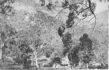
Photograph - B/W, c 1870
... By 1870 they and their young family had settled in the area at the entrance of the Fyans Valley and on the west of Fyans Creek. There they built a home and recognising the needs of passing travellers and timber-getters, they established Delley's Inn, providing food and refreshments to all in need....By 1870 they and their young family had settled in the area at the entrance of the Fyans Valley and on the west of Fyans Creek. There they built a home and recognising the needs of passing travellers and timber-getters, they established Delley's Inn, providing food and refreshments to all in need. ...Jane and Samuel Delley emigrated to Australia in 1857. By 1870 they and their young family had settled in the area at the entrance of the Fyans Valley and on the west of Fyans Creek. There they built a home and recognising the needs of passing travellers and timber-getters, they established Delley's Inn, providing food and refreshments to all in need.Timber dwelling with bark roof and two chimneys, one at either side of the house. In front stand four men and two women with two wagon drays in the foreground. The area is enclosed by picket fencing close to the house and a rough timber fence on the rear of the boundary. Delley's Inn,1870 on reverse in pencilbuildings, houses, accommodation, delley's inn -
 Halls Gap & Grampians Historical Society
Photograph - B/W, C 1880
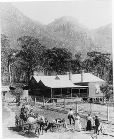
... 1880-1902 Land owned by Robert and Sarah Graham who owned a large portion of land best described as Upper Fyans Valley. At some time after 1880, they sold a parcel of the land under Sundial Peak to David Austin who built a slab hut. ...Halls Gap & Grampians Historical Society Centennial Hall 117-119 Grampians Road Halls Gap grampians 1880-1902 Land owned by Robert and Sarah Graham who owned a large portion of land best described as Upper Fyans Valley. At some time after 1880, they sold a parcel of the land under Sundial Peak to David Austin who built a slab hut. ...1880-1902 Land owned by Robert and Sarah Graham who owned a large portion of land best described as Upper Fyans Valley. At some time after 1880, they sold a parcel of the land under Sundial Peak to David Austin who built a slab hut. C1896, The land was sold to James and Amy Balmain which they named 'Bellfield' Amy was a daughter of John D/Alton who built the Stawell Water Supply System. Balmain purchased the vacant school cottage at Burnt Bridge and moved it to 'Bellfield' Over the next six years the house was enlarged to accommodate their growing family but sold in 1902 following the death of Amy Balmain.House with addition People leaving house by horse and carriage, people standing in groundsState Library Victoria, Rose's Australasian Views Victorian Series photographed and published by George Rose 123 Chapel St., Windsor, Victoriabuildings, houses, bellfield -
 Stawell Historical Society Inc
Photograph, Postcard set c.1940
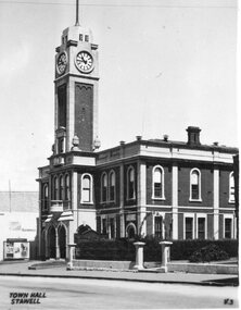
... This is a popular walk in the Wonderland Range. 11 The Whale’s Mouth Wonderland Range Grampians 12 Relph Peak in the Wonderland Range looking down on the Fyans Valley and Halls Gap 13 Bellfield Peak is part of the Wonderland Range overlooking Halls Gap and the Fyans Valley 14 Gateway of the East Winds on the Wonderland Walk 15 Mackenzie Falls on the Mackenzie River and downstream from Wartook Reservoir. ...This is a popular walk in the Wonderland Range. 11 The Whale’s Mouth Wonderland Range Grampians 12 Relph Peak in the Wonderland Range looking down on the Fyans Valley and Halls Gap 13 Bellfield Peak is part of the Wonderland Range overlooking Halls Gap and the Fyans Valley 14 Gateway of the East Winds on the Wonderland Walk 15 Mackenzie Falls on the Mackenzie River and downstream from Wartook Reservoir. ...-1 Stawell Town Hall, with newly constructed clocktower -2 Main Street, Looking west towards the Grampians -3 Stawell from Big Hill, looking west towards the Grampians 4 Cato Lake, looking west towards the railway line. Swimming Club Rooms on the Left, Bandstand on the Right 5 The Gardens Sundial, donated by the family of Edward Simmons who owned the Oriental Gold Mine 6 Central Park Sports Oval looking north to the Grandstand. Cricket match being played. This is the site of the annual running of the Stawell Gift. 7 Pioneers’ Memorial on Big Hill. Built in 1938 and a popular viewing area of Stawell and the Grampians Mountain Range. 8 Sisters Rocks, on London Road and the Western Highway corner. It has been a popular place for graffiti for decades. 9 The Balconies (also known as the “ Jaws of Death ) Mt Victory Grampians. It is near Reids lookout and both have excellent views of the Victoria Valley. 10 The Grand Canyon Grampians. This is a popular walk in the Wonderland Range. 11 The Whale’s Mouth Wonderland Range Grampians 12 Relph Peak in the Wonderland Range looking down on the Fyans Valley and Halls Gap 13 Bellfield Peak is part of the Wonderland Range overlooking Halls Gap and the Fyans Valley 14 Gateway of the East Winds on the Wonderland Walk 15 Mackenzie Falls on the Mackenzie River and downstream from Wartook Reservoir. This is a popular visiting place for tourists. 16 Wartook Reservoir, serving as part of Horsham’s water supply. Black & White Photograph Postcards Setstawell tourism -
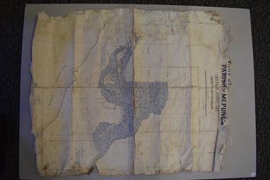
 Halls Gap & Grampians Historical Society
Map - Coloured
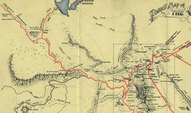
... Hall, squatter on Mokepilly Run 1841-1842, first European to discover the Fyans Creek valley, the entrance of which became known as Hall's Gap. ...Hall, squatter on Mokepilly Run 1841-1842, first European to discover the Fyans Creek valley, the entrance of which became known as Hall's Gap. ...Background on Bridle Path up Stony Creek Gorge Pre 1840 C. B. Hall, squatter on Mokepilly Run 1841-1842, first European to discover the Fyans Creek valley, the entrance of which became known as Hall's Gap. He later recorded that he followed a number of tracks which he assumed had been made by the Aboriginies and described one as "leading up a wild romantic glen and over on to the source of the Glenelg River". This could well have been the route taken up Stony Creek gorge by the first timber-cutters in this part of the Grampians to the saddle between the Wonderland and Mt. Difficult ranges known as Valley Gap 1850s/60s Timber cutters and shingle splitters were reported to be moving into the eastern side of the Grampians and by the mid 1860s there were a number of families connected to the supplying of timber to Pleasant Creek living in the "Hall's Gap ranges". John Wakeham, the first store owner in Pleasant Creek in 1854, established a timer-mill in upper Stony Creek Gorge in the late 1850s. Wakeham is credited for the clearing and levelling of the first bridle-path up the gorge. 1870s By the mid 1870s the track had been extended over Valley Gap to the Victoria Forest (the upper region of the Victoria Valley). McKeon's bullock team was known to have hauled red gum from the Valley to Stawell in the late 1870s and the 1880s. 1880s In 1887 an article in the Pleasant Creek news describes the Stony Creek Gorge track as "being a ledge alongside the mountain range, formed in the early days with the aid of earth and timber, along which the bullock teams used to travel to Horsham and plains of the Wimmera beyond." 1890s Gold was discovered in the catchment area of Stony Creek and by the end of the 1890s a new track was built from "near the junction of Fyan's and Stony Creeks, up the gorge to the diggings settlement. The mining Department had paid L300 for its construction and, when completed, the track was "three miles and 30 chains in length, the side cuttings at the narrowest part being 10 feet between" and "the watercourses which cross the track at various points" having been "filled up with rocks rolled down the sides of the hills, and consequently there can be no damage caused by bushfires which destroyed the former wooden bridges erected on the old track to Wakeham's saw-mill, the remains of which are still to be seen at the side of the diggings" The article goes on to further describe the track as one which "can with ease travel with a two horse conveyance either up or down" and that the workmen engaged in the construction of the track would be attending "a ball that night at McKeon's farm near the mouth of the gap to celebrate the successful completion of the undertaking". 1900s At what time the bridle path was extended beyond Valley Gap to the Wartook basin on the Mt. Difficult Range has not yet been determined. However, it is known that, by the turn of the century, people were travelling between Halls Gap and the caretakers' residence at Wartook Reservoir along what was now known as the "Bluff Road. Wartook's embankment had been constructed in 1887 and at that time there was already a track from Rosebrook Station homestead (near the present day Wartook Pottery) to the reservoir. Philip Rose owned both Rosebrook and Wartook Stations from the mid 1840s to the late 1850s and had regularly leased the Wartook basin to Cobb & Co. to rest horses there. 1920s Following the war of 1914-1918, tourism really took off in the Grampians, and Halls Gap rapidly grew. People would travel as far as they could on the many tracks then hike to the many lookouts being discovered by local tour guides. This led to the need for access across the range so that horse riders and the increasing number of vehicles could travel between Horsham and Halls Gap. To this end, the Bluff Road was improved and extended on 1929 and at its opening in March, 1930, by Lady Somers it was renamed the Mt. Victory Road.Map of Mt Victory Road and othersaccess routes, mt victory rd, bridle path, roads -
 Warrnambool and District Historical Society Inc.
Map - Maps, Soldiers Settlement WW2, Circa 1950
... The maps are as follows: .1 Narrapumelap Estate ( Ripon & Hampden) .2 Narrapumelap Estate Part 2 (Villers & Ripon) .3 Narrapumelap Estate Part 3 ( Villiers & Ripon) .4 Burrumbeet Estate ( Ripon) .5 ' Berrambool' Estate 9 Hampden & Villiers) .6 ' Hopkins Hill' Estate Villiers 4011 acres .7 Caramut North No 2 Estate ( Villiers ) .8 ' Morpor' Estate ( Villiers) 4172 acres .9 ' Morgiana' Estate ( Normandy) 3453 acres .10 ' Chatsworth House' ( Villiers) 9341 Acres .11 ' East Elwood' Estate Villiers 2407 acres .12 Grey's Estate ( Mornington) 1151acres .13 ' Rowes Estate' ( Buln Buln Gippsland 733 acres .14 'Tarrone' Estate No 2 Part map .15 'Chaldon Meade' Estate (Bourke) Bulla 517 acres .16 ' Terranallum South' Estate Hampden 3757 acres .17 ' Brung Brungle' Estate Dundas 695 .18 ' Armidale ' Estate ( Dundas)2108 acres .19 ' Moyne Falls' Estate ( Villiers) 627 acres .20' Yulong' Estate 9 Lowan 6321 acres .21 Murray Valley Irrigation District 9 Moira)113 acres .22 Murray Valley Irrigation District 103 acres .23 ' Mount Fyans' Estate ( Hampden) .24 ' Barwidgee ' Estate ( Villiers) 4277 acres .25 'Pine Hills' Estate 2nd portion ( Lowan) 6190 acres ...As such they have historic and social interest and significance. narrapumelap berrambool hopkins hill caramut north morpor chatsworth house east elwood terrinallum moyne falls tarrone caramut soldiers settlers Burrumbeet morgiana grey's estate mornington chaldon meade brung brungle The maps are as follows: .1 Narrapumelap Estate ( Ripon & Hampden) .2 Narrapumelap Estate Part 2 (Villers & Ripon) .3 Narrapumelap Estate Part 3 ( Villiers & Ripon) .4 Burrumbeet Estate ( Ripon) .5 ' Berrambool' Estate 9 Hampden & Villiers) .6 ' Hopkins Hill' Estate Villiers 4011 acres .7 Caramut North No 2 Estate ( Villiers ) .8 ' Morpor' Estate ( Villiers) 4172 acres .9 ' Morgiana' Estate ( Normandy) 3453 acres .10 ' Chatsworth House' ( Villiers) 9341 Acres .11 ' East Elwood' Estate Villiers 2407 acres .12 Grey's Estate ( Mornington) 1151acres .13 ' Rowes Estate' ( Buln Buln Gippsland 733 acres .14 'Tarrone' Estate No 2 Part map .15 'Chaldon Meade' Estate (Bourke) Bulla 517 acres .16 ' Terranallum South' Estate Hampden 3757 acres .17 ' Brung Brungle' Estate Dundas 695 .18 ' Armidale ' Estate ( Dundas)2108 acres .19 ' Moyne Falls' Estate ( Villiers) 627 acres .20' Yulong' Estate 9 Lowan 6321 acres .21 Murray Valley Irrigation District 9 Moira)113 acres .22 Murray Valley Irrigation District 103 acres .23 ' Mount Fyans' Estate ( Hampden) .24 ' Barwidgee ' Estate ( Villiers) 4277 acres .25 'Pine Hills' Estate 2nd portion ( Lowan) 6190 acres A collection of 25 paper maps which relate to to the soldiers settlement post World War 2. ...The soldiers' settlement scheme operated after the first and second world wars in an effort to more closely settle the land and also give opportunities to returned soldiers. Crown land and other larger estates were acquired for the purpose. Most of these maps relate to the area north of Warrnambool where many of the subdivisions were parts of larger estates.These maps pertaining to the Soldiers' Settlement program, relate to an interesting part of Australian and local history. As such they have historic and social interest and significance.A collection of 25 paper maps which relate to to the soldiers settlement post World War 2. Some have details of the people allocated the land and some smaller maps have the printed details of the applicants requirements.Text is black on white paper which in some cases is quite aged. The maps are as follows: .1 Narrapumelap Estate ( Ripon & Hampden) .2 Narrapumelap Estate Part 2 (Villers & Ripon) .3 Narrapumelap Estate Part 3 ( Villiers & Ripon) .4 Burrumbeet Estate ( Ripon) .5 ' Berrambool' Estate 9 Hampden & Villiers) .6 ' Hopkins Hill' Estate Villiers 4011 acres .7 Caramut North No 2 Estate ( Villiers ) .8 ' Morpor' Estate ( Villiers) 4172 acres .9 ' Morgiana' Estate ( Normandy) 3453 acres .10 ' Chatsworth House' ( Villiers) 9341 Acres .11 ' East Elwood' Estate Villiers 2407 acres .12 Grey's Estate ( Mornington) 1151acres .13 ' Rowes Estate' ( Buln Buln Gippsland 733 acres .14 'Tarrone' Estate No 2 Part map .15 'Chaldon Meade' Estate (Bourke) Bulla 517 acres .16 ' Terranallum South' Estate Hampden 3757 acres .17 ' Brung Brungle' Estate Dundas 695 .18 ' Armidale ' Estate ( Dundas)2108 acres .19 ' Moyne Falls' Estate ( Villiers) 627 acres .20' Yulong' Estate 9 Lowan 6321 acres .21 Murray Valley Irrigation District 9 Moira)113 acres .22 Murray Valley Irrigation District 103 acres .23 ' Mount Fyans' Estate ( Hampden) .24 ' Barwidgee ' Estate ( Villiers) 4277 acres .25 'Pine Hills' Estate 2nd portion ( Lowan) 6190 acres narrapumelap, berrambool, hopkins hill, caramut north, morpor, chatsworth house, east elwood, terrinallum, moyne falls, tarrone, caramut soldiers settlers, burrumbeet, morgiana, grey's estate mornington, chaldon meade, brung brungle -
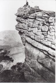 Halls Gap & Grampians Historical Society
Photograph - B/W, C 1930s
... Valley in photo is Fyans. Peak is thought to be Bellfield. ...Halls Gap & Grampians Historical Society Centennial Hall 117-119 Grampians Road Halls Gap grampians Valley in photo is Fyans. Peak is thought to be Bellfield. ...Valley in photo is Fyans. Peak is thought to be Bellfield. Photo shows a man seated on rocky outcrop looking out over a valley. he is wearing a hat and suit coat.scenery, peaks