Showing 45 items matching "gellibrand hill"
-
 Sunbury Family History and Heritage Society Inc.
Photograph, Gellibrand Hill, c1989
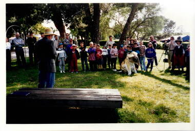
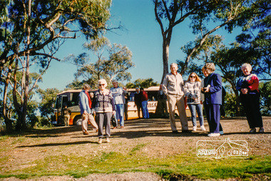
... Gellibrand Hill...Gellibrand Hill...The children from Bulla Primary School were taken on an excursion to Gellibrand Hill Park which is a short distance from the School. ...Gellibrand Hill...There are buildings visible in the background. Gellibrand Hill Photograph Gellibrand Hill ...The children from Bulla Primary School were taken on an excursion to Gellibrand Hill Park which is a short distance from the School. The emphasis on the day's excursion was to identify the native fauna in the park as well as the vegetation.The property was originally settled by the Greene family in 1843. In 1980 the State Government purchased the property and it is now one of the state's parks where the natural vegetation has gradually been restored on the property. A non-digital coloured photograph with a cream border, of a group of adults and children listening to a man who is standing in front of a low seat and talking to them. There are buildings visible in the background. gellibrand hill, bulla primary school, school excursions -
 Sunbury Family History and Heritage Society Inc.
Photograph, Gellibrand Hill, 1987
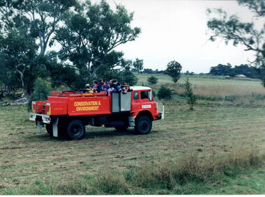
... Gellibrand Hill......Gellibrand Hill...The children from Bulla Primary School were taken for a ride around Gellibrand Hill on the back of a truck used by the park rangers at Gellibrand Hill near Bulla. ...Sunbury Global Learning Centre Macedon Street Sunbury melbourne The children from Bulla Primary School were taken for a ride around Gellibrand Hill on the back of a truck used by the park rangers at Gellibrand Hill near Bulla. ...The children from Bulla Primary School were taken for a ride around Gellibrand Hill on the back of a truck used by the park rangers at Gellibrand Hill near Bulla. The rangers were responsible for maintaining the bushland in the park and the students were at the park doing some tree planting.The excursion was included in then children's science and environmental studies.A non-digital photograph of a group of children in the back of a red conservation and environment truck in a bushland park.tree planting, gellibrand hill, bulla primary school, conservation -
 Sunbury Family History and Heritage Society Inc.
Photograph, Gellibrand Hill, 1987
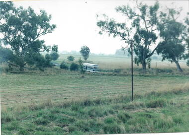
... Gellibrand Hill...Gellibrand Hill...After a day at Gellibrand Hill where the students from Bulla Primary School were engaged in tree-planting and being shown around the park, they were driven back to school in their small school bus during a very sudden rain storm....Gellibrand Hill Photograph Bulla Primary School ...After a day at Gellibrand Hill where the students from Bulla Primary School were engaged in tree-planting and being shown around the park, they were driven back to school in their small school bus during a very sudden rain storm.A non-digital photograph of a small bus driving out of a natural parkland.gellibrand hill, school excursions, bulla primary school -
 Sunbury Family History and Heritage Society Inc.
Photograph, Gellibrand Hill, 1987
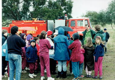
... Gellibrand Hill...Gellibrand Hill...The students from Bulla Primary School were enjoying a tree-planting excursion at Gellibrand Hill and while they were taken for a ride around the park by the park ranger, the entire group were caught in a sudden shower of rain and had to take shelter under a large tarpaulin....Gellibrand Hill Photograph Bulla Primary School ...The students from Bulla Primary School were enjoying a tree-planting excursion at Gellibrand Hill and while they were taken for a ride around the park by the park ranger, the entire group were caught in a sudden shower of rain and had to take shelter under a large tarpaulin.A non-digital coloured photograph of children huddled under a large waterproof sheet to shelter from a sudden shower of rain with the truck which they were all on is parked a short distance from them.gellibrand hill, school excursions, bulla primary school -
 Sunbury Family History and Heritage Society Inc.
Photograph, Gellibrand Hill, 1987
... Gellibrand Hill...Gellibrand Hill...The students from Bulla Primary School were taken on an excursion to Gellibrand Hill, a native parkland near Bulla. They did tree-planting and were taken for a ride around the park in the conservation and environment truck. ...They are in a semi-bushland area. Gellibrand Hill Photograph Bulla Primary School ...The students from Bulla Primary School were taken on an excursion to Gellibrand Hill, a native parkland near Bulla. They did tree-planting and were taken for a ride around the park in the conservation and environment truck. After the ride a park ranger spoke to the group about the park and its importance in the local area.The excursion was included as part of the students science and environmental studies.A non-digital photograph of a group of children gathered around a red truck controlled by the Conservation and Environment personnel while a man explains to the children the importance of the vehicle. They are in a semi-bushland area. gellibrand hill, tree planting, bulla primary school, school excursions -
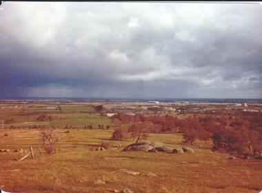
 Hume City Civic Collection
Photograph, early 1980s
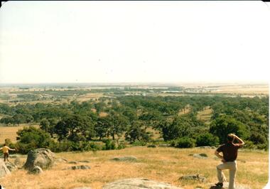
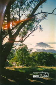
... gellibrand hill...The Tullamarine Airport opened in 1970 and replaced Essendon Airport as Melbourne's main airport terminal. Gellibrand Hill was incorporated with Woodlands Park and became a public reserve during the 1980s....A coloured landscape photograph with rounded corners taken from Gellibrand Hill and overlooking the Tullamarine Airport which is on the RHS of the photograph. ...Hume City Civic Collection 44 Macedon Street Sunbury melbourne The Tullamarine Airport opened in 1970 and replaced Essendon Airport as Melbourne's main airport terminal. Gellibrand Hill was incorporated with Woodlands Park and became a public reserve during the 1980s. gellibrand hill tullamarine airport melbourne skyline george evans collection A coloured landscape photograph with rounded corners taken from Gellibrand Hill and overlooking the Tullamarine Airport which is on the RHS of the photograph. ...The Tullamarine Airport opened in 1970 and replaced Essendon Airport as Melbourne's main airport terminal. Gellibrand Hill was incorporated with Woodlands Park and became a public reserve during the 1980s.A coloured landscape photograph with rounded corners taken from Gellibrand Hill and overlooking the Tullamarine Airport which is on the RHS of the photograph. The Melbourne City skyline can be seen in the distance.gellibrand hill, tullamarine airport, melbourne skyline, george evans collection -
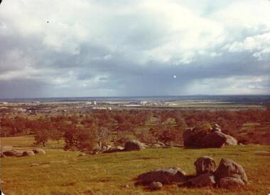
 Hume City Civic Collection
Photograph, September 1994
... ...gellibrand hill...Woodlands Park complex which includes 'Cumberland' and 'Dundonald' ruins and the Gellibrand Hill Quarries was acquired by the Victorian State Government in 1978 and is managed by Parks Victoria....A view looking west towards the outer limits of the Tullamarine Airport taken from Gellibrand Hill. There is a small rocky outcrop in the middle of the photograph and trees are on the RHS of the image. ...Hume City Civic Collection 44 Macedon Street Sunbury melbourne Woodlands Park complex which includes 'Cumberland' and 'Dundonald' ruins and the Gellibrand Hill Quarries was acquired by the Victorian State Government in 1978 and is managed by Parks Victoria. woodlands park gellibrand hill greene william pomeroy anne george evans collection A view looking west towards the outer limits of the Tullamarine Airport taken from Gellibrand Hill. ...Woodlands Park complex which includes 'Cumberland' and 'Dundonald' ruins and the Gellibrand Hill Quarries was acquired by the Victorian State Government in 1978 and is managed by Parks Victoria.A view looking west towards the outer limits of the Tullamarine Airport taken from Gellibrand Hill. There is a small rocky outcrop in the middle of the photograph and trees are on the RHS of the image. Coloured photograph with rounded corners and matt finish.woodlands park, gellibrand hill, greene, william pomeroy, anne, george evans collection -
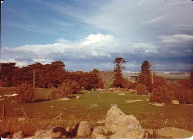 Hume City Civic Collection
Photograph, Sep-94
... ...gellibrand hill...Woodlands Park complex which includes 'Cumberland' and 'Dundonald' ruins and the Gellibrand Hill Quarries was acquired by the Victorian State Government in 1978 and is managed by Parks Victoria....A view taken from Gellibrand Hill looking northwest. The open grassed area in the foreground is dotted with a number of rocky outcrops with conifers and cypress trees in the background. ...Hume City Civic Collection 44 Macedon Street Sunbury melbourne Woodlands Park complex which includes 'Cumberland' and 'Dundonald' ruins and the Gellibrand Hill Quarries was acquired by the Victorian State Government in 1978 and is managed by Parks Victoria. woodlands park gellibrand hill greene william pomeroy anne george evans collection A view taken from Gellibrand Hill looking northwest. ...Woodlands Park complex which includes 'Cumberland' and 'Dundonald' ruins and the Gellibrand Hill Quarries was acquired by the Victorian State Government in 1978 and is managed by Parks Victoria.A view taken from Gellibrand Hill looking northwest. The open grassed area in the foreground is dotted with a number of rocky outcrops with conifers and cypress trees in the background. There are a few buildings in the distance.Coloured photograph with rounded corners and matt finish.woodlands park, gellibrand hill, greene, william pomeroy, anne, george evans collection -
 Hume City Civic Collection
Photograph, Sep-94
... ...gellibrand hill...Woodlands Park complex which includes 'Cumberland' and 'Dundonald' ruins and the Gellibrand Hill Quarries was acquired by the Victorian State Government in 1978 and is managed by Parks Victoria....A view taken from Gellibrand Hill looking towards the recently constructed Tullamarine (Melbourne) Airport. ...Hume City Civic Collection 44 Macedon Street Sunbury melbourne Woodlands Park complex which includes 'Cumberland' and 'Dundonald' ruins and the Gellibrand Hill Quarries was acquired by the Victorian State Government in 1978 and is managed by Parks Victoria. woodlands park gellibrand hill greene william pomeroy anne george evans collection A view taken from Gellibrand Hill looking towards the recently constructed Tullamarine (Melbourne) Airport. ...Woodlands Park complex which includes 'Cumberland' and 'Dundonald' ruins and the Gellibrand Hill Quarries was acquired by the Victorian State Government in 1978 and is managed by Parks Victoria.A view taken from Gellibrand Hill looking towards the recently constructed Tullamarine (Melbourne) Airport. The airport buildings are just beyond an outcrop of trees. Four rocky outcrops are spread around the foreground. Coloured photograph with rounded corners and matt finish.woodlands park, gellibrand hill, greene, william pomeroy, anne, george evans collection -
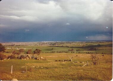 Hume City Civic Collection
Photograph, September 1994
... ...gellibrand hill...Woodlands Park complex which includes 'Cumberland' and 'Dundonald' ruins and the Gellibrand Hill Quarries was acquired by the Victorian State Government in 1978 and is managed by Parks Victoria....A view taken from Gellibrand Hill looking east towards the expanding suburb of Broadmeadows. ...Hume City Civic Collection 44 Macedon Street Sunbury melbourne Woodlands Park complex which includes 'Cumberland' and 'Dundonald' ruins and the Gellibrand Hill Quarries was acquired by the Victorian State Government in 1978 and is managed by Parks Victoria. woodlands park gellibrand hill greene william pomeroy anne george evans collection A view taken from Gellibrand Hill looking east towards the expanding suburb of Broadmeadows. ...Woodlands Park complex which includes 'Cumberland' and 'Dundonald' ruins and the Gellibrand Hill Quarries was acquired by the Victorian State Government in 1978 and is managed by Parks Victoria.A view taken from Gellibrand Hill looking east towards the expanding suburb of Broadmeadows. Apart from a few rocky outcrops and small trees the open grassland slopes away to a small line of conifers. Coloured photograph with rounded corners and matt finish.woodlands park, gellibrand hill, greene, william pomeroy, anne, george evans collection -
 Hume City Civic Collection
Photograph, early 1980s
... gellibrand hill...Gellibrand Hill along with the surrounding 3 properties: Attwood, Cumberland and Woodlands were incorporated into Gellibrand Park during the 1980s. ...A coloured landscape photograph with rounded corners of the Tullamarine Airport taken from Gellibrand Hill. A man with his back to the camera is on the RHS and another person is running down the hill on the LHS. ...Tullamarine became Melbourne's main air terminal in 1970 and replaced Essendon Airport. gellibrand hill tullamarine airport george evans collection A coloured landscape photograph with rounded corners of the Tullamarine Airport taken from Gellibrand Hill. ...Gellibrand Hill along with the surrounding 3 properties: Attwood, Cumberland and Woodlands were incorporated into Gellibrand Park during the 1980s. Tullamarine became Melbourne's main air terminal in 1970 and replaced Essendon Airport.A coloured landscape photograph with rounded corners of the Tullamarine Airport taken from Gellibrand Hill. A man with his back to the camera is on the RHS and another person is running down the hill on the LHS. The area in the middle distance is lightly treed and the airport is in the distance to the right of the photograph.gellibrand hill, tullamarine airport, george evans collection -
 Hume City Civic Collection
Photograph, September 1994
... ...gellibrand hill...Woodlands Park complex which includes 'Cumberland' and 'Dundonald' ruins and the Gellibrand Hill Quarries was acquired by the Victorian State Government in 1978 and is managed by Parks Victoria....A view taken from Gellibrand Hill looking east towards the developing suburb of Greenvale. ...Hume City Civic Collection 44 Macedon Street Sunbury melbourne Woodlands Park complex which includes 'Cumberland' and 'Dundonald' ruins and the Gellibrand Hill Quarries was acquired by the Victorian State Government in 1978 and is managed by Parks Victoria. woodlands park gellibrand hill greene william pomeroy anne george evans collection A view taken from Gellibrand Hill looking east towards the developing suburb of Greenvale. ...Woodlands Park complex which includes 'Cumberland' and 'Dundonald' ruins and the Gellibrand Hill Quarries was acquired by the Victorian State Government in 1978 and is managed by Parks Victoria.A view taken from Gellibrand Hill looking east towards the developing suburb of Greenvale. There are small rocky outcrops in the foreground and a clump of conifers and cypress trees in the middle. The sky is very overcast and a range of mountains can be seen across the skyline. Coloured photograph with rounded corners and matt finish.woodlands park, gellibrand hill, greene, william pomeroy, anne, george evans collection -
 Sunbury Family History and Heritage Society Inc.
Photograph, Rosa McCall, Cumberland Homestead, 1951
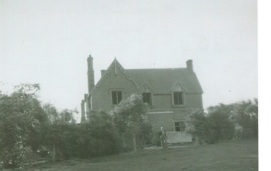
... ...Gellibrand Hill...The homestead in the image is 'Cumberland' which was sited along the Moonee Ponds Creek, near Gellibrand Hill. It was built by Donald Coghill, who acquired the land some time in the 1850s. ...The homestead in the image is 'Cumberland' which was sited along the Moonee Ponds Creek, near Gellibrand Hill. It was built by Donald Coghill, who acquired the land some time in the 1850s. ...The homestead in the image is 'Cumberland' which was sited along the Moonee Ponds Creek, near Gellibrand Hill. It was built by Donald Coghill, who acquired the land some time in the 1850s. During the first half of the twentieth century it was uninhabited until it was finally demolished.'Cumberland' was one of a number of homesteads that were built by European settlers in the Bulla area in the 1850s. A non-digital black and white photograph of a double storey Victorian homestead set in an open area.cumberland homestead, moonee ponds creek, gellibrand hill, donald coghill -
 Sunbury Family History and Heritage Society Inc.
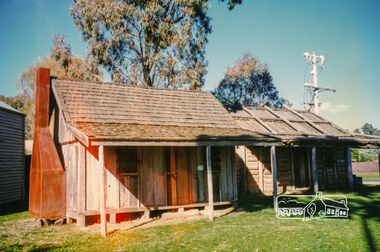
Artwork, other, Ian Symonds, Woodlands Homestead
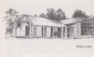
... ...Gellibrand Hill...William Pomeroy Greene, from Scotland settled on land near Gellibrand Hill and Moonee Ponds Creek at Bulla and built his prefabricated homestead own the site....William Pomeroy Greene, from Scotland settled on land near Gellibrand Hill and Moonee Ponds Creek at Bulla and built his prefabricated homestead own the site. ...The sketch of Woodlands Homestead is a reproduction of Ian Symonds original drawing. He was a Sunbury resident and was an active member in the local art group and gallery. He drew many black and white drawings of interesting homesteads and sites in the district. William Pomeroy Greene, from Scotland settled on land near Gellibrand Hill and Moonee Ponds Creek at Bulla and built his prefabricated homestead own the site.The Greene family were one of the early European settlers to settle in Bulla. A photograph of a black and white sketch of a homestead.WOODLANDSwoodlands homestead, gellibrand hill, william pomeroy greene, bulla, moonee ponds creek -
 Federation University Historical Collection
Map, Otways Walks and Waterfalls Map, 2013, 06/2013
... colac, lorne, apollo bay, beech forest, forrest, barwon downs, deans march, winchelsea, gellibrand, lavers hill, port campbel, princetown, johanna, timboon, cobden, camperdown, swan marsh, simpson, birregurra, beeac, marengo, wye river, kennett river, skenes creek, peterborough< marriners falls, beauchamp falls, hopetoun falls, triplet falls, little aire falls, stevensons falls...Tourist map of the Otways showing the townships of Colac, Lorne, Apollo Bay, Beech Forest, Forrest, Barwon Downs, Deans March, Winchelsea, Gellibrand, Lavers Hill, POrt Campbel, Princetown, Johanna, Timboon, Cobden, Camperdown, Swan Marsh, Simpson, Birregurra, Beeac, Marengo, Wye River, Kennett River, Skenes Creek, Peterborough...Barker Library (top floor) Mount Helen goldfields colac, lorne, apollo bay, beech forest, forrest, barwon downs, deans march, winchelsea, gellibrand, lavers hill, port campbel, princetown, johanna, timboon, cobden, camperdown, swan marsh, simpson, birregurra, beeac, marengo, wye river, kennett river, skenes creek, peterborough< marriners falls, beauchamp falls, hopetoun falls, triplet falls, little aire falls, stevensons falls Tourist map of the Otways showing the townships of Colac, Lorne, Apollo Bay, Beech Forest, Forrest, Barwon Downs, Deans March, Winchelsea, Gellibrand, Lavers Hill, POrt Campbel, Princetown, Johanna, Timboon, Cobden, Camperdown, Swan Marsh, Simpson, Birregurra, Beeac, Marengo, Wye River, Kennett River, Skenes Creek, Peterborough Otways Walks and Waterfalls Map, 2013 Map ...Tourist map of the Otways showing the townships of Colac, Lorne, Apollo Bay, Beech Forest, Forrest, Barwon Downs, Deans March, Winchelsea, Gellibrand, Lavers Hill, POrt Campbel, Princetown, Johanna, Timboon, Cobden, Camperdown, Swan Marsh, Simpson, Birregurra, Beeac, Marengo, Wye River, Kennett River, Skenes Creek, Peterboroughcolac, lorne, apollo bay, beech forest, forrest, barwon downs, deans march, winchelsea, gellibrand, lavers hill, port campbel, princetown, johanna, timboon, cobden, camperdown, swan marsh, simpson, birregurra, beeac, marengo, wye river, kennett river, skenes creek, peterborough< marriners falls, beauchamp falls, hopetoun falls, triplet falls, little aire falls, stevensons falls -
 Hume City Civic Collection
Photograph
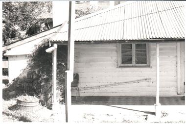
... ...gellibrand hill...In 1978 654 acres of the original property was purchased by the state government and placed under the management of the National Park Service. woodlands homestead greene william pomeroy anne woodlands park gellibrand hill george evans collection A black and white photograph of part of a building showing the verandah with a paved floor. ...Woodlands Homestead was erected by William Greene in 1843 and is one of the state's oldest buildings. Over the years the complex has been renovated and extended. The property has connections with the racing industry over the years along with the neighbouring properties of 'Cumberland' and 'Attwood'. In 1978 654 acres of the original property was purchased by the state government and placed under the management of the National Park Service.A black and white photograph of part of a building showing the verandah with a paved floor. The hipped roof is covered with corrugated iron and the walls are weatherboard. An old steel kitchen chair is on the LHS at the end of the verandah and asparagus fern is growing up over the rear wall.woodlands homestead, greene, william pomeroy, anne, woodlands park, gellibrand hill, george evans collection -
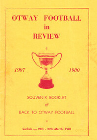 Otway Districts Historical Society
Book, Colac Herald Press, Otway football in review, 1981
... otways; football; history; wyelangta; beech forest; carlisle; lavers hill; gellibrand; johanna;...Otway Districts Historical Society Cliff Young Drive Beech Forest great-ocean-road Souvenir booklet of Back to Otway Football from 1907 until 1980, with an emphasis from 1921 onwards, intends to restore and preserve at least some of the history of Otway football. otways; football; history; wyelangta; beech forest; carlisle; lavers hill; gellibrand; johanna; Otway football in review, 1907-1980. ...Souvenir booklet of Back to Otway Football from 1907 until 1980, with an emphasis from 1921 onwards, intends to restore and preserve at least some of the history of Otway football.Otway football in review, 1907-1980. Mark Kempton (ed.). 1st ed. Colac (Vic); Herald Print; 1981. 48 p.; illus. Soft cover.otways; football; history; wyelangta; beech forest; carlisle; lavers hill; gellibrand; johanna; -
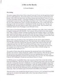 Otway Districts Historical Society
Document, Norman Houghton, A bite on the Beechy. Norman Houghton, c.2011
... beech forest; colac; railways; gellibrand; wyelangta; lavers hill; crowes;...Otway Districts Historical Society Cliff Young Drive Beech Forest great-ocean-road beech forest; colac; railways; gellibrand; wyelangta; lavers hill; crowes; A bite on the Beechy. ...A bite on the Beechy. Norman Houghton. Norman Houghton; Geelong (Vic); c.2011. 7 p.; refs. Paper.beech forest; colac; railways; gellibrand; wyelangta; lavers hill; crowes; -
 Hume City Civic Collection
Photograph, Woodlands Homestead, c1858 - 59
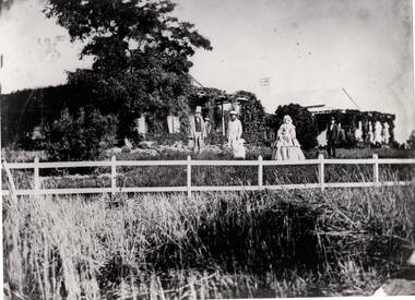
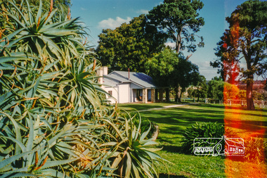
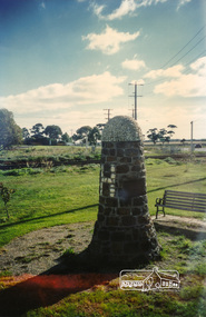
... He acquired the Crown land at Gellibrand Hill in 1843 and built the prefabricated homestead which became known as Woodlands. ...He acquired the Crown land at Gellibrand Hill in 1843 and built the prefabricated homestead which became known as Woodlands. ...The photograph is of the Woodland Homestead at Bulla which was sited along the Moonee Ponds Creek. William Pomroy Greene and his wife Anne, emigrated from Scotland and arrived in the Port Phillip area in December 1842.. He acquired the Crown land at Gellibrand Hill in 1843 and built the prefabricated homestead which became known as Woodlands. The people in the photograph, taken about 1859 - 60, are L- R: Possibly Sir Willian Stawell, ?, little Anne Catherine Greene at 2 years, Rawdon Greene, Mrs. Greene and Smith ( a butler).The Greene family were one of the early European settlers to acquire land in the Bulla Bulla district. The Woodlands property is now a national park and the significant Gellibrand Hill is within the park.A black and white photograph of 3 men, a lady and a child standing in a garden in front of a homestead. A wooden post and rail fence is in the foregroundwoodlands homestead, greene family -
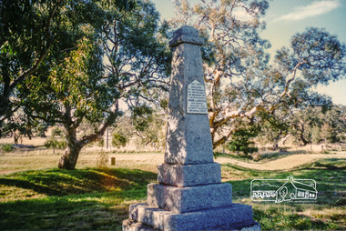 Eltham District Historical Society Inc
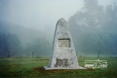
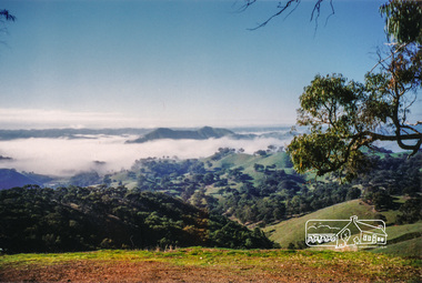
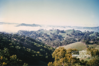
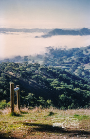
Photograph, Hume and Hovell Monument, Broadford, Autumn Excursion, Hume and Hovell's 1824 expedition, 26 May 1996, 26/05/1996
... After morning tea at Broadford we followed the Sunday Creek valley beside the Hume Freeway, passed the Wallan Wallan Rest Area (more appropriately Hume and Hovell Rest Area) to tum right at Beveridge. In Gellibrand Hill Park, near the headwaters of the Moonee Ponds Creek, we experienced the landscape the first European settlers saw - huge river red gums and rolling pastures. ...After morning tea at Broadford we followed the Sunday Creek valley beside the Hume Freeway, passed the Wallan Wallan Rest Area (more appropriately Hume and Hovell Rest Area) to tum right at Beveridge. In Gellibrand Hill Park, near the headwaters of the Moonee Ponds Creek, we experienced the landscape the first European settlers saw - huge river red gums and rolling pastures. ...[article by Bettina Woodburn in EDHS Newsletter No. 109, July 1996:] ON THE TRAIL OF HUME AND HOVELL - REPORT ON THE AUTUMN EXCURSION - On a green and fresh morning (Sunday 26th May 1996) the Cobb and Co coach (driven by the most obliging Peter Tampion) set off in a north easterly direction from Eltham to connect with Hume and Hovell's route on their 1824 explorations of central Victoria. The Society would follow a series of monuments erected for the 1924 centenary of the expedition from King Parrot Creek (Tuesday 7th December 1824), through Strath Creek, over Sunday Creek (Sunday 12th December 1824) at Broadford, Tullamarine, St Albans, Deer Park, through Werribee, skirting east of the You Yangs to Lara and Avalon Beach. Because their distance-measuring wheel had broken and a one degree mistake was made in calculations, the two leaders of the original group of six convict-companions arrived at Corio Bay, instead of the expected Western Port, discovered earlier by Flinders. From below Mt. Disappointment (Hume and Hovell's difficulties in "scrambling over brush and rock", "leeches in forest, as well as no water", "cutting grass 4-5 ft. high", dreadful scrub", "devil flies") we took an easier route, saw the Strath Creek memorial in ground fog and a wonderful "field of dreams", the Hume-Hovell privately owned cricket ground with its white picket boundary fence. Now, after a steep climb, in sunshine under gums we stretched and viewed magnificent rolling hills and fog-filled valleys - not "smoke from Aborigines' bush fires". After morning tea at Broadford we followed the Sunday Creek valley beside the Hume Freeway, passed the Wallan Wallan Rest Area (more appropriately Hume and Hovell Rest Area) to tum right at Beveridge. In Gellibrand Hill Park, near the headwaters of the Moonee Ponds Creek, we experienced the landscape the first European settlers saw - huge river red gums and rolling pastures. The gardens and sheltered courtyard of the 1840s, timber, brought from .....[?] prefabricated Woodlands Homestead, provided a pleasant lunch stop. We enjoyed a private tour, panoramic views over Melbourne and surroundings and the excitement of arriving and departing aircraft. Our next river crossing was at Werribee, "in a vast treeless plain", then we drove on by-ways no coach had previously travelled, to find "an immense sheet of water" salty Corio Bay, off-course to the west. In late afternoon of a super, calm, late autumn day we headed homewards. Back at Eltham we were rather surprised to find that we had travelled a total of 347 km. Thanks again to Russell Yeoman for his research and organization. What a wonderful day! Colour photographactivities, broadford, hume and hovell, monument -
 Eltham District Historical Society Inc
Photograph, Strath Creek, Autumn Excursion, Hume and Hovell's 1824 expedition, 26 May 1996, 26/05/1996
... After morning tea at Broadford we followed the Sunday Creek valley beside the Hume Freeway, passed the Wallan Wallan Rest Area (more appropriately Hume and Hovell Rest Area) to tum right at Beveridge. In Gellibrand Hill Park, near the headwaters of the Moonee Ponds Creek, we experienced the landscape the first European settlers saw - huge river red gums and rolling pastures. ...After morning tea at Broadford we followed the Sunday Creek valley beside the Hume Freeway, passed the Wallan Wallan Rest Area (more appropriately Hume and Hovell Rest Area) to tum right at Beveridge. In Gellibrand Hill Park, near the headwaters of the Moonee Ponds Creek, we experienced the landscape the first European settlers saw - huge river red gums and rolling pastures. ...[article by Bettina Woodburn in EDHS Newsletter No. 109, July 1996:] ON THE TRAIL OF HUME AND HOVELL - REPORT ON THE AUTUMN EXCURSION - On a green and fresh morning (Sunday 26th May 1996) the Cobb and Co coach (driven by the most obliging Peter Tampion) set off in a north easterly direction from Eltham to connect with Hume and Hovell's route on their 1824 explorations of central Victoria. The Society would follow a series of monuments erected for the 1924 centenary of the expedition from King Parrot Creek (Tuesday 7th December 1824), through Strath Creek, over Sunday Creek (Sunday 12th December 1824) at Broadford, Tullamarine, St Albans, Deer Park, through Werribee, skirting east of the You Yangs to Lara and Avalon Beach. Because their distance-measuring wheel had broken and a one degree mistake was made in calculations, the two leaders of the original group of six convict-companions arrived at Corio Bay, instead of the expected Western Port, discovered earlier by Flinders. From below Mt. Disappointment (Hume and Hovell's difficulties in "scrambling over brush and rock", "leeches in forest, as well as no water", "cutting grass 4-5 ft. high", dreadful scrub", "devil flies") we took an easier route, saw the Strath Creek memorial in ground fog and a wonderful "field of dreams", the Hume-Hovell privately owned cricket ground with its white picket boundary fence. Now, after a steep climb, in sunshine under gums we stretched and viewed magnificent rolling hills and fog-filled valleys - not "smoke from Aborigines' bush fires". After morning tea at Broadford we followed the Sunday Creek valley beside the Hume Freeway, passed the Wallan Wallan Rest Area (more appropriately Hume and Hovell Rest Area) to tum right at Beveridge. In Gellibrand Hill Park, near the headwaters of the Moonee Ponds Creek, we experienced the landscape the first European settlers saw - huge river red gums and rolling pastures. The gardens and sheltered courtyard of the 1840s, timber, brought from .....[?] prefabricated Woodlands Homestead, provided a pleasant lunch stop. We enjoyed a private tour, panoramic views over Melbourne and surroundings and the excitement of arriving and departing aircraft. Our next river crossing was at Werribee, "in a vast treeless plain", then we drove on by-ways no coach had previously travelled, to find "an immense sheet of water" salty Corio Bay, off-course to the west. In late afternoon of a super, calm, late autumn day we headed homewards. Back at Eltham we were rather surprised to find that we had travelled a total of 347 km. Thanks again to Russell Yeoman for his research and organization. What a wonderful day! Colour photographactivities, monument, hume and hovell, murchison valley, strath creek -
 Eltham District Historical Society Inc
Photograph, Murchison Gap viewed from Strath Creek, Autumn Excursion, Hume and Hovell's 1824 expedition, 26 May 1996, 26/05/1996
... After morning tea at Broadford we followed the Sunday Creek valley beside the Hume Freeway, passed the Wallan Wallan Rest Area (more appropriately Hume and Hovell Rest Area) to tum right at Beveridge. In Gellibrand Hill Park, near the headwaters of the Moonee Ponds Creek, we experienced the landscape the first European settlers saw - huge river red gums and rolling pastures. ...After morning tea at Broadford we followed the Sunday Creek valley beside the Hume Freeway, passed the Wallan Wallan Rest Area (more appropriately Hume and Hovell Rest Area) to tum right at Beveridge. In Gellibrand Hill Park, near the headwaters of the Moonee Ponds Creek, we experienced the landscape the first European settlers saw - huge river red gums and rolling pastures. ...[article by Bettina Woodburn in EDHS Newsletter No. 109, July 1996:] ON THE TRAIL OF HUME AND HOVELL - REPORT ON THE AUTUMN EXCURSION - On a green and fresh morning (Sunday 26th May 1996) the Cobb and Co coach (driven by the most obliging Peter Tampion) set off in a north easterly direction from Eltham to connect with Hume and Hovell's route on their 1824 explorations of central Victoria. The Society would follow a series of monuments erected for the 1924 centenary of the expedition from King Parrot Creek (Tuesday 7th December 1824), through Strath Creek, over Sunday Creek (Sunday 12th December 1824) at Broadford, Tullamarine, St Albans, Deer Park, through Werribee, skirting east of the You Yangs to Lara and Avalon Beach. Because their distance-measuring wheel had broken and a one degree mistake was made in calculations, the two leaders of the original group of six convict-companions arrived at Corio Bay, instead of the expected Western Port, discovered earlier by Flinders. From below Mt. Disappointment (Hume and Hovell's difficulties in "scrambling over brush and rock", "leeches in forest, as well as no water", "cutting grass 4-5 ft. high", dreadful scrub", "devil flies") we took an easier route, saw the Strath Creek memorial in ground fog and a wonderful "field of dreams", the Hume-Hovell privately owned cricket ground with its white picket boundary fence. Now, after a steep climb, in sunshine under gums we stretched and viewed magnificent rolling hills and fog-filled valleys - not "smoke from Aborigines' bush fires". After morning tea at Broadford we followed the Sunday Creek valley beside the Hume Freeway, passed the Wallan Wallan Rest Area (more appropriately Hume and Hovell Rest Area) to tum right at Beveridge. In Gellibrand Hill Park, near the headwaters of the Moonee Ponds Creek, we experienced the landscape the first European settlers saw - huge river red gums and rolling pastures. The gardens and sheltered courtyard of the 1840s, timber, brought from .....[?] prefabricated Woodlands Homestead, provided a pleasant lunch stop. We enjoyed a private tour, panoramic views over Melbourne and surroundings and the excitement of arriving and departing aircraft. Our next river crossing was at Werribee, "in a vast treeless plain", then we drove on by-ways no coach had previously travelled, to find "an immense sheet of water" salty Corio Bay, off-course to the west. In late afternoon of a super, calm, late autumn day we headed homewards. Back at Eltham we were rather surprised to find that we had travelled a total of 347 km. Thanks again to Russell Yeoman for his research and organization. What a wonderful day! Colour photographactivities, hume and hovell, murchison valley, murchison gap, strath creek -
 Eltham District Historical Society Inc
Photograph, Autumn Excursion, Hume and Hovell's 1824 expedition, 26 May 1996, 26/05/1996
... After morning tea at Broadford we followed the Sunday Creek valley beside the Hume Freeway, passed the Wallan Wallan Rest Area (more appropriately Hume and Hovell Rest Area) to tum right at Beveridge. In Gellibrand Hill Park, near the headwaters of the Moonee Ponds Creek, we experienced the landscape the first European settlers saw - huge river red gums and rolling pastures. ...After morning tea at Broadford we followed the Sunday Creek valley beside the Hume Freeway, passed the Wallan Wallan Rest Area (more appropriately Hume and Hovell Rest Area) to tum right at Beveridge. In Gellibrand Hill Park, near the headwaters of the Moonee Ponds Creek, we experienced the landscape the first European settlers saw - huge river red gums and rolling pastures. ...[article by Bettina Woodburn in EDHS Newsletter No. 109, July 1996:] ON THE TRAIL OF HUME AND HOVELL - REPORT ON THE AUTUMN EXCURSION - On a green and fresh morning (Sunday 26th May 1996) the Cobb and Co coach (driven by the most obliging Peter Tampion) set off in a north easterly direction from Eltham to connect with Hume and Hovell's route on their 1824 explorations of central Victoria. The Society would follow a series of monuments erected for the 1924 centenary of the expedition from King Parrot Creek (Tuesday 7th December 1824), through Strath Creek, over Sunday Creek (Sunday 12th December 1824) at Broadford, Tullamarine, St Albans, Deer Park, through Werribee, skirting east of the You Yangs to Lara and Avalon Beach. Because their distance-measuring wheel had broken and a one degree mistake was made in calculations, the two leaders of the original group of six convict-companions arrived at Corio Bay, instead of the expected Western Port, discovered earlier by Flinders. From below Mt. Disappointment (Hume and Hovell's difficulties in "scrambling over brush and rock", "leeches in forest, as well as no water", "cutting grass 4-5 ft. high", dreadful scrub", "devil flies") we took an easier route, saw the Strath Creek memorial in ground fog and a wonderful "field of dreams", the Hume-Hovell privately owned cricket ground with its white picket boundary fence. Now, after a steep climb, in sunshine under gums we stretched and viewed magnificent rolling hills and fog-filled valleys - not "smoke from Aborigines' bush fires". After morning tea at Broadford we followed the Sunday Creek valley beside the Hume Freeway, passed the Wallan Wallan Rest Area (more appropriately Hume and Hovell Rest Area) to tum right at Beveridge. In Gellibrand Hill Park, near the headwaters of the Moonee Ponds Creek, we experienced the landscape the first European settlers saw - huge river red gums and rolling pastures. The gardens and sheltered courtyard of the 1840s, timber, brought from .....[?] prefabricated Woodlands Homestead, provided a pleasant lunch stop. We enjoyed a private tour, panoramic views over Melbourne and surroundings and the excitement of arriving and departing aircraft. Our next river crossing was at Werribee, "in a vast treeless plain", then we drove on by-ways no coach had previously travelled, to find "an immense sheet of water" salty Corio Bay, off-course to the west. In late afternoon of a super, calm, late autumn day we headed homewards. Back at Eltham we were rather surprised to find that we had travelled a total of 347 km. Thanks again to Russell Yeoman for his research and organization. What a wonderful day! Colour photographactivities, hume and hovell -
 Eltham District Historical Society Inc
Photograph, Sign to Hume and Hovell Cricket Ground, at Allandale Road, Strath Creek, Autumn Excursion, Hume and Hovell's 1824 expedition, 26 May 1996, 26/05/1996
... After morning tea at Broadford we followed the Sunday Creek valley beside the Hume Freeway, passed the Wallan Wallan Rest Area (more appropriately Hume and Hovell Rest Area) to tum right at Beveridge. In Gellibrand Hill Park, near the headwaters of the Moonee Ponds Creek, we experienced the landscape the first European settlers saw - huge river red gums and rolling pastures. ...After morning tea at Broadford we followed the Sunday Creek valley beside the Hume Freeway, passed the Wallan Wallan Rest Area (more appropriately Hume and Hovell Rest Area) to tum right at Beveridge. In Gellibrand Hill Park, near the headwaters of the Moonee Ponds Creek, we experienced the landscape the first European settlers saw - huge river red gums and rolling pastures. ...[article by Bettina Woodburn in EDHS Newsletter No. 109, July 1996:] ON THE TRAIL OF HUME AND HOVELL - REPORT ON THE AUTUMN EXCURSION - On a green and fresh morning (Sunday 26th May 1996) the Cobb and Co coach (driven by the most obliging Peter Tampion) set off in a north easterly direction from Eltham to connect with Hume and Hovell's route on their 1824 explorations of central Victoria. The Society would follow a series of monuments erected for the 1924 centenary of the expedition from King Parrot Creek (Tuesday 7th December 1824), through Strath Creek, over Sunday Creek (Sunday 12th December 1824) at Broadford, Tullamarine, St Albans, Deer Park, through Werribee, skirting east of the You Yangs to Lara and Avalon Beach. Because their distance-measuring wheel had broken and a one degree mistake was made in calculations, the two leaders of the original group of six convict-companions arrived at Corio Bay, instead of the expected Western Port, discovered earlier by Flinders. From below Mt. Disappointment (Hume and Hovell's difficulties in "scrambling over brush and rock", "leeches in forest, as well as no water", "cutting grass 4-5 ft. high", dreadful scrub", "devil flies") we took an easier route, saw the Strath Creek memorial in ground fog and a wonderful "field of dreams", the Hume-Hovell privately owned cricket ground with its white picket boundary fence. Now, after a steep climb, in sunshine under gums we stretched and viewed magnificent rolling hills and fog-filled valleys - not "smoke from Aborigines' bush fires". After morning tea at Broadford we followed the Sunday Creek valley beside the Hume Freeway, passed the Wallan Wallan Rest Area (more appropriately Hume and Hovell Rest Area) to tum right at Beveridge. In Gellibrand Hill Park, near the headwaters of the Moonee Ponds Creek, we experienced the landscape the first European settlers saw - huge river red gums and rolling pastures. The gardens and sheltered courtyard of the 1840s, timber, brought from .....[?] prefabricated Woodlands Homestead, provided a pleasant lunch stop. We enjoyed a private tour, panoramic views over Melbourne and surroundings and the excitement of arriving and departing aircraft. Our next river crossing was at Werribee, "in a vast treeless plain", then we drove on by-ways no coach had previously travelled, to find "an immense sheet of water" salty Corio Bay, off-course to the west. In late afternoon of a super, calm, late autumn day we headed homewards. Back at Eltham we were rather surprised to find that we had travelled a total of 347 km. Thanks again to Russell Yeoman for his research and organization. What a wonderful day! Colour photographactivities, hume and hovell, allandale road, strath creek -
 Eltham District Historical Society Inc
Photograph, Autumn Excursion, Hume and Hovell's 1824 expedition, 26 May 1996, 26/05/1996
... After morning tea at Broadford we followed the Sunday Creek valley beside the Hume Freeway, passed the Wallan Wallan Rest Area (more appropriately Hume and Hovell Rest Area) to tum right at Beveridge. In Gellibrand Hill Park, near the headwaters of the Moonee Ponds Creek, we experienced the landscape the first European settlers saw - huge river red gums and rolling pastures. ...After morning tea at Broadford we followed the Sunday Creek valley beside the Hume Freeway, passed the Wallan Wallan Rest Area (more appropriately Hume and Hovell Rest Area) to tum right at Beveridge. In Gellibrand Hill Park, near the headwaters of the Moonee Ponds Creek, we experienced the landscape the first European settlers saw - huge river red gums and rolling pastures. ...[article by Bettina Woodburn in EDHS Newsletter No. 109, July 1996:] ON THE TRAIL OF HUME AND HOVELL - REPORT ON THE AUTUMN EXCURSION - On a green and fresh morning (Sunday 26th May 1996) the Cobb and Co coach (driven by the most obliging Peter Tampion) set off in a north easterly direction from Eltham to connect with Hume and Hovell's route on their 1824 explorations of central Victoria. The Society would follow a series of monuments erected for the 1924 centenary of the expedition from King Parrot Creek (Tuesday 7th December 1824), through Strath Creek, over Sunday Creek (Sunday 12th December 1824) at Broadford, Tullamarine, St Albans, Deer Park, through Werribee, skirting east of the You Yangs to Lara and Avalon Beach. Because their distance-measuring wheel had broken and a one degree mistake was made in calculations, the two leaders of the original group of six convict-companions arrived at Corio Bay, instead of the expected Western Port, discovered earlier by Flinders. From below Mt. Disappointment (Hume and Hovell's difficulties in "scrambling over brush and rock", "leeches in forest, as well as no water", "cutting grass 4-5 ft. high", dreadful scrub", "devil flies") we took an easier route, saw the Strath Creek memorial in ground fog and a wonderful "field of dreams", the Hume-Hovell privately owned cricket ground with its white picket boundary fence. Now, after a steep climb, in sunshine under gums we stretched and viewed magnificent rolling hills and fog-filled valleys - not "smoke from Aborigines' bush fires". After morning tea at Broadford we followed the Sunday Creek valley beside the Hume Freeway, passed the Wallan Wallan Rest Area (more appropriately Hume and Hovell Rest Area) to tum right at Beveridge. In Gellibrand Hill Park, near the headwaters of the Moonee Ponds Creek, we experienced the landscape the first European settlers saw - huge river red gums and rolling pastures. The gardens and sheltered courtyard of the 1840s, timber, brought from .....[?] prefabricated Woodlands Homestead, provided a pleasant lunch stop. We enjoyed a private tour, panoramic views over Melbourne and surroundings and the excitement of arriving and departing aircraft. Our next river crossing was at Werribee, "in a vast treeless plain", then we drove on by-ways no coach had previously travelled, to find "an immense sheet of water" salty Corio Bay, off-course to the west. In late afternoon of a super, calm, late autumn day we headed homewards. Back at Eltham we were rather surprised to find that we had travelled a total of 347 km. Thanks again to Russell Yeoman for his research and organization. What a wonderful day! Colour photographactivities, hume and hovell -
 Eltham District Historical Society Inc
Photograph, Autumn Excursion, Hume and Hovell's 1824 expedition, 26 May 1996, 26/05/1996
... After morning tea at Broadford we followed the Sunday Creek valley beside the Hume Freeway, passed the Wallan Wallan Rest Area (more appropriately Hume and Hovell Rest Area) to tum right at Beveridge. In Gellibrand Hill Park, near the headwaters of the Moonee Ponds Creek, we experienced the landscape the first European settlers saw - huge river red gums and rolling pastures. ...After morning tea at Broadford we followed the Sunday Creek valley beside the Hume Freeway, passed the Wallan Wallan Rest Area (more appropriately Hume and Hovell Rest Area) to tum right at Beveridge. In Gellibrand Hill Park, near the headwaters of the Moonee Ponds Creek, we experienced the landscape the first European settlers saw - huge river red gums and rolling pastures. ...[article by Bettina Woodburn in EDHS Newsletter No. 109, July 1996:] ON THE TRAIL OF HUME AND HOVELL - REPORT ON THE AUTUMN EXCURSION - On a green and fresh morning (Sunday 26th May 1996) the Cobb and Co coach (driven by the most obliging Peter Tampion) set off in a north easterly direction from Eltham to connect with Hume and Hovell's route on their 1824 explorations of central Victoria. The Society would follow a series of monuments erected for the 1924 centenary of the expedition from King Parrot Creek (Tuesday 7th December 1824), through Strath Creek, over Sunday Creek (Sunday 12th December 1824) at Broadford, Tullamarine, St Albans, Deer Park, through Werribee, skirting east of the You Yangs to Lara and Avalon Beach. Because their distance-measuring wheel had broken and a one degree mistake was made in calculations, the two leaders of the original group of six convict-companions arrived at Corio Bay, instead of the expected Western Port, discovered earlier by Flinders. From below Mt. Disappointment (Hume and Hovell's difficulties in "scrambling over brush and rock", "leeches in forest, as well as no water", "cutting grass 4-5 ft. high", dreadful scrub", "devil flies") we took an easier route, saw the Strath Creek memorial in ground fog and a wonderful "field of dreams", the Hume-Hovell privately owned cricket ground with its white picket boundary fence. Now, after a steep climb, in sunshine under gums we stretched and viewed magnificent rolling hills and fog-filled valleys - not "smoke from Aborigines' bush fires". After morning tea at Broadford we followed the Sunday Creek valley beside the Hume Freeway, passed the Wallan Wallan Rest Area (more appropriately Hume and Hovell Rest Area) to tum right at Beveridge. In Gellibrand Hill Park, near the headwaters of the Moonee Ponds Creek, we experienced the landscape the first European settlers saw - huge river red gums and rolling pastures. The gardens and sheltered courtyard of the 1840s, timber, brought from .....[?] prefabricated Woodlands Homestead, provided a pleasant lunch stop. We enjoyed a private tour, panoramic views over Melbourne and surroundings and the excitement of arriving and departing aircraft. Our next river crossing was at Werribee, "in a vast treeless plain", then we drove on by-ways no coach had previously travelled, to find "an immense sheet of water" salty Corio Bay, off-course to the west. In late afternoon of a super, calm, late autumn day we headed homewards. Back at Eltham we were rather surprised to find that we had travelled a total of 347 km. Thanks again to Russell Yeoman for his research and organization. What a wonderful day! Colour photographactivities, hume and hovell