Showing 42 items matching "geological formations"
-
 University of Melbourne, Burnley Campus Archives
Booklet - Photocopy, G.B. Pritchard, Old Yarra History as told by the …Geology of Burnley Heyington Tooronga, 1944
... ...geological formations...Describing the geological formations in the Burnley area. (Burnley, Heyington, Tooronga)...g.b. pritchard f.w. cheshire geology of burnley geological formations geology victoria geology near burnley victoria old yarra history Booklet by G.B. ...Booklet by G.B. Pritchard, publ. F.W. Cheshire, Melbourne, 1944,3- 29pp and front cover. Describing the geological formations in the Burnley area. (Burnley, Heyington, Tooronga)g.b. pritchard, f.w. cheshire, geology of burnley, geological formations, geology victoria, geology near burnley victoria, old yarra history -
 Phillip Island and District Historical Society Inc.
Photograph
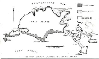
... Photograph of a map of Phillip Island showing a late stage in the geological formation...Phillip Island and District Historical Society Inc. phillip-island-and-the-bass-coast One of a collection of over 400 photographs in an album commenced in 1960 and presented to the Phillip Island & Westernport Historical Society by the Shire of Phillip Island local history photography phillip island black & white photograph phillip island geology map Map of Phillip Island John Jenner Bryant West Photograph of a map of Phillip Island showing a late stage in the geological formation Photograph Bryant West Dr G Baker ...One of a collection of over 400 photographs in an album commenced in 1960 and presented to the Phillip Island & Westernport Historical Society by the Shire of Phillip IslandPhotograph of a map of Phillip Island showing a late stage in the geological formationlocal history, photography, phillip island, black & white photograph, phillip island geology, map, map of phillip island, john jenner, bryant west -
 Bendigo Historical Society Inc.
Document - VICTORIA HILL - KEY TO SIGN POSTS ON AREA MAP
... Sign posts were for mines and their associated equipment and geological formations. Initialled AR. Notes prepared by Albert Richardson....Sign posts were for mines and their associated equipment and geological formations. Initialled AR. Notes prepared by Albert Richardson. ...Photocopied handwritten notes with typed copy of same, on Sign Posts on Victoria Hill.. Sign posts were for mines and their associated equipment and geological formations. Initialled AR. Notes prepared by Albert Richardson.document, victoria hill, key to sign posts on area map, north old chum shaft, ballerstedt's first open cut, rock formatins, lansell's big 180, 20 stampers crushing battery, foundations 'cleopatra needle' type chimney, victoria quartz mine, rae's open cut, quartz roasting, anticlinal arch, primitive tunnels, coloured rock formations, adit, oblique fault, spurry quartz veins, prospecting tunnels, floyd's small crushing battery, gt central victoria (midway) shaft -
Kew Historical Society Inc
Archive (Sub-series) - Subject File, Kew Historical Society, Geology (Kew), 1958
... These include a Parks Victoria brochure on the Geology of Yarra Bend Park and a printout of a web page about the Collingwood Children’s Farm that includes information about the geological formation of the region....These include a Parks Victoria brochure on the Geology of Yarra Bend Park and a printout of a web page about the Collingwood Children’s Farm that includes information about the geological formation of the region. Geology (Kew) Archive Subject File Kew Historical Society ...Various partiesReference, Research, InformationSecondary Values (KHS Imposed Order)Subject file containing some secondary sources. These include a Parks Victoria brochure on the Geology of Yarra Bend Park and a printout of a web page about the Collingwood Children’s Farm that includes information about the geological formation of the region.kew historical society - archives, geology - kew (vic)kew historical society - archives, geology - kew (vic) -
 Bendigo Historical Society Inc.
Document - VICTORIA HILL - QUESTION 5 ON VICTORIA HILL
... Also contains notes on machinery, geological formations and earning from the mines....Also contains notes on machinery, geological formations and earning from the mines. Document VICTORIA HILL - QUESTION 5 ON VICTORIA HILL ...Handwritten notes and carbon copy titled Question 5. Notes refer to Victoria Hill being opened up by Theodore Ballerstedt and his son early in 1854. Theodore Ballerstedt left for Germany having sold his home, crushing battery and mine to Mr. Geo Lansell. He called the mine the '180'. Next mine north to the '180' was the Victoria Quartz. Also contains notes on machinery, geological formations and earning from the mines.document, gold, victoria hill, victoria hill, question 5 on victoria hill, theodore ballerstedt, mr geo lansell, fortuna villa, commonwealth survey regiment, the 180, ballerstedt's original open cut, bendigo south rotary club, john wybrandt, north old chum coy, victoria quartz, victoria reef quartz company, mr william rae, a roberts & sons united ironworks, australian mining standard special edition 1899, bendigo advertiser 10/2/1897, a harkness & coy, bendigo advertiser 30/6/1910 page 5, rae's open cut, e j dunn, bendigo saddle reefs, wittscheibe's 'jeweller's shop', roberts & frost, ashley noy & coy, grant & co, woodward & son, couth allen and co, taylor gould and co, crawshaw & co, roberts & co -
 Federation University Historical Collection
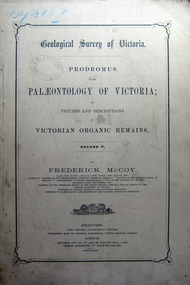
Book, Prodromus of the Palaeontology of Victoria No iv, 1876 (exact)
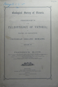
... This publication consists of many Decades which contain "figuers and descriptions of the fossil organic remains to be used for the determination of the geological ages of the different geological formations of the country." (p. 3). Frederick McCoy was born in Dublin, Ireland in 1817. ...Barker Library (top floor) Mount Helen goldfields This publication consists of many Decades which contain "figuers and descriptions of the fossil organic remains to be used for the determination of the geological ages of the different geological formations of the country." (p. 3). Frederick McCoy was born in Dublin, Ireland in 1817. ...This publication consists of many Decades which contain "figuers and descriptions of the fossil organic remains to be used for the determination of the geological ages of the different geological formations of the country." (p. 3). Frederick McCoy was born in Dublin, Ireland in 1817. He was a Professor of Natural Sciences, University of Melbourne 1854-1899. McCoy lectured in geology, zoology, chemistry, mineralogy, geography and botany. In 1858 He became the Director of the National Museum of Victoria and the President of the Royal Society of Victoria in 1864. In 1888, McCoy was awarded FRS for work in Palaeontology in Ireland, England and Australia. He died in his office while correcting examination papers in 1899A Paperback cover book. Decade IV. Title is written in black on front cover and on title page. At head of title: Geological Survey of Victoria. Illustrations, plates in b/w; 32 p. It includes figures and descriptions of Victorian Organic Remains and contents of Decades on the back cover of the book.australia palaeobotany, victoria palaeontology, geological survey of victoria, frederick mccoy, organic remains -
 Federation University Historical Collection
Book, Prodromus of the Palaeontology of Victoria, 1877 (exact)
... This publication consists of many Decades which contain "figuers and descriptions of the fossil organic remains to be used for the determination of the geological ages of the different geological formations of the country." (p. 3). Frederick McCoy was born in Dublin, Ireland in 1817. ...Barker Library (top floor) Mount Helen goldfields This publication consists of many Decades which contain "figuers and descriptions of the fossil organic remains to be used for the determination of the geological ages of the different geological formations of the country." (p. 3). Frederick McCoy was born in Dublin, Ireland in 1817. ...This publication consists of many Decades which contain "figuers and descriptions of the fossil organic remains to be used for the determination of the geological ages of the different geological formations of the country." (p. 3). Frederick McCoy was born in Dublin, Ireland in 1817. He was a Professor of Natural Sciences, University of Melbourne 1854-1899. McCoy lectured in geology, zoology, chemistry, mineralogy, geography and botany. In 1858 He became the Director of the National Museum of Victoria and the President of the Royal Society of Victoria in 1864. In 1888, McCoy was awarded FRS for work in Palaeontology in Ireland, England and Australia. He died in his office while correcting examination papers in 1899.A Paperback cover book. Decade v. Title is written in black on front cover and on title page. At head of title: Geological Survey of Victoria. Illustrations, plates in b/w; 41 p. It includes figures and descriptions of Victorian Organic Remains and contents of Decades on back cover.Stamped Ballarat East Public Library"australia palaeobotany, victoria palaeontology, geological survey of victoria, frederick mccoy, organic remains, ballarat east library, ballarat east public library -
 Federation University Historical Collection
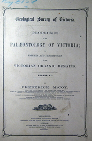
Book, John Ferres, Government Printer, Prodromus of the Palaeontology of Victoria Decade vi, 1878 (exact)
... This publication consists of many Decades which contain "figuers and descriptions of the fossil organic remains to be used for the determination of the geological ages of the different geological formations of the country." (p. 3). Frederick McCoy was born in Dublin, Ireland in 1817. ...Barker Library (top floor) Mount Helen goldfields This publication consists of many Decades which contain "figuers and descriptions of the fossil organic remains to be used for the determination of the geological ages of the different geological formations of the country." (p. 3). Frederick McCoy was born in Dublin, Ireland in 1817. ...This publication consists of many Decades which contain "figuers and descriptions of the fossil organic remains to be used for the determination of the geological ages of the different geological formations of the country." (p. 3). Frederick McCoy was born in Dublin, Ireland in 1817. He was a Professor of Natural Sciences, University of Melbourne 1854-1899. McCoy lectured in geology, zoology, chemistry, mineralogy, geography and botany. In 1858 He became the Director of the National Museum of Victoria and the President of the Royal Society of Victoria in 1864. In 1888, McCoy was awarded FRS for work in Palaeontology in Ireland, England and Australia. He died in his office while correcting examination papers in 1899.A Paperback cover book. Decade VI. Title is written in black on front cover and on title page. At head of title: Geological Survey of Victoria. Illustrations, plates in b/w; 42 p. It includes figures and descriptions of Victorian Organic Remains and contents of Decades at back of the book.australia palaeobotany, victoria palaeontology, geological survey of victoria, frederick mccoy, organic remains, john ferres -
 Sunbury Family History and Heritage Society Inc.
Photograph, Bulla Primary School, Hanging Rock, 1995
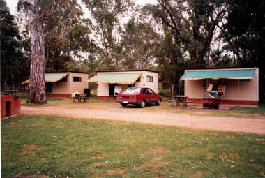
... At this camp the students were shown basic rock climbing skills and explored the rock for its interesting geological formations. Hanging Rock, also known as Mount Diogenes, is the traditional land of the Dja Dja Wurrung, Woi Wurrung and Taungurung people. ...At this camp the students were shown basic rock climbing skills and explored the rock for its interesting geological formations. Hanging Rock, also known as Mount Diogenes, is the traditional land of the Dja Dja Wurrung, Woi Wurrung and Taungurung people. ...In 1995, the upper school students from Bulla Primary School attended a camp at Hanging Rock Reserve which is part of the Macedon Ranges. At this camp the students were shown basic rock climbing skills and explored the rock for its interesting geological formations. Hanging Rock, also known as Mount Diogenes, is the traditional land of the Dja Dja Wurrung, Woi Wurrung and Taungurung people. It is a mamelon formed when magma poured from a vent and congealed. There are interesting rock functions at the site such as the Colonnade, the Eagle and the UFO. The highest point on the rock is 718metres above sea level and 105 meters above the land at its base.Hanging Rock is an important geological and volcanic structure in the Macedon Ranges area and in central Victoria. A non-digital coloured photograph of three holiday cabins and a barbecue in a bushland setting. A red car is parked outside one of the cabins as well as two permanent picnic tables.hanging rock, mount diogenes, mamelons, volcanoes, school camps, bulla primary school -
 Kiewa Valley Historical Society
Sample Tubes
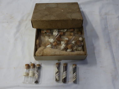
... Part of Geological investigation into the characteristics of the rock formations and ground water....Kiewa Valley Historical Society Mount Beauty Information Centre 31 Bogong High Plains Rd Mt Beauty high-country Part of Geological investigation into the characteristics of the rock formations and ground water. ...Part of Geological investigation into the characteristics of the rock formations and ground water.Water supply and infrastructure requires prior investigation before construction work can commence.Very small glass tubes (about 30) with cork toppers. Each tube is labelled. Resting on wool in a cardboard box with a lid. Stored in an old thick cardboard box with a very faint 'Harrietville ... Samples' on its lid.On the tubes - place and number "Harrietville / samples"geological samples, harrietville water -
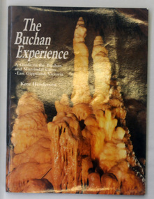 Orbost & District Historical Society
magazine, List Print Nominees, The Buchan Experience, 1985
... geology Buchan Inside on fly is "Mary Gilbert" hand-written in black felt tip. A soft cover, 64 pp stapled magazine with a glossy cover. On the cover is a coloured photograph of limestone stalagmite formations in a cave. ...This magazine is a guide to the Buchan and Murrindal Caves of East Gippsland. From 1985 to 1993 Kent Henderson had published a number of full colour tourist-orientated books about limestone caves. This book is the second in the series. This one and a book on Jenolan Caves, in New South Wales, are the only two still in print.This item is a valuable research tool on the history of Buchan and in particular, The Buchan Caves.A soft cover, 64 pp stapled magazine with a glossy cover. On the cover is a coloured photograph of limestone stalagmite formations in a cave. The magazine contains coloured photographs and historical information about Buchan Caves.Inside on fly is "Mary Gilbert" hand-written in black felt tip.caves-victoria-buchan geology buchan -
 Federation University Historical Collection
Document, SMB: Catalogue of a Collection of Rocks, Minerals, etc, 1883
... Geological Survey of India. One Hundred items are listed. Pages 4 and 5 also show diagrams relating to the land formations and sections. ...Geological Survey of India. One Hundred items are listed. Pages 4 and 5 also show diagrams relating to the land formations and sections. ...This list of rocks, minerals, etc. from Victoria was complied and forwarded by the School of Mines, Ballarat, to the Calcutta International Exhibition. At the end of the exhibition the items were to be presented to the Geological Survey of India. One Hundred items are listed. Pages 4 and 5 also show diagrams relating to the land formations and sections. Places in Victoria are named indicating where items were found. List compiled by Professor Ferdinand Moritz Krause. He joined Ballarat School of Mines in 1880 and lectured in Mineralogy and Geology. He was also the Curator of the Ballarat School of Mines Museum.6 pages, handwrittenSignature of F M Krause Dated 30th August 1883ballarat school of mines, rocks, minerals, calcutta international exhibition, geology survey of india, victoria, professor ferdinand moritz krause, mineralogy, geology, curator, ballarat school of mines museum -
 Federation University Historical Collection
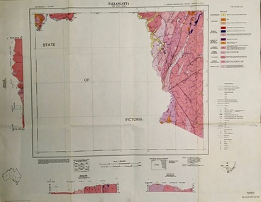
Map - Geological, Tallangatta, New South Wales: 1:250,000 Geological Series, SJ 55-3, 1966, 1966
... Geology. Topographical base compiled from Snowy Mountains Hydro Electrical Authority, Department of Lands, County maps and Snowy Lease Map. Other sheet adjoin this map. There are 13 formation...Geology. Topographical base compiled from Snowy Mountains Hydro Electrical Authority, Department of Lands, County maps and Snowy Lease Map. Other sheet adjoin this map. There are 13 formation ...Compiled by the Geological Survey of N.S.W., Division of Regional Geology. Topographical base compiled from Snowy Mountains Hydro Electrical Authority, Department of Lands, County maps and Snowy Lease Map. Other sheet adjoin this map. There are 13 formation sections grouped into 9 - Quaternary, Tertiary, Middle Devonian, Lower to Middle Devonian, Lower Devonian, Upper Silurian, Silurian, Upper Ordovician and Ordovician.Large coloured map showing geological features, faults, bores, rivers and mineral deposits.Scale of map, longitude and latitude, river names. "Tallangatta 1:250,00" written in black pen.tallangatta, new south wales, geological survey, topographical base, snowy mountains hydro electrical authority, department of lands, snowy lease map, department of mines, quaternary, tertiary, middle devonian, lower to middle devonian, lower devonian, uper siluran, silurian, upper ordovician, ordovician -
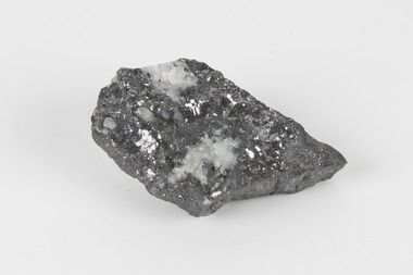
 The Beechworth Burke Museum
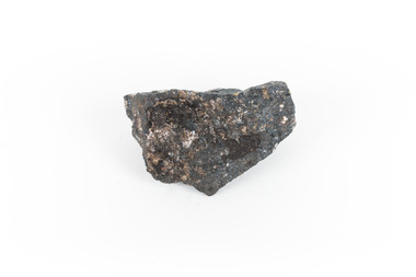
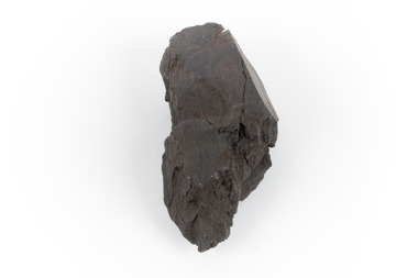
Geological specimen - Ilvaite
... A solid hand-sized ferrous iron analogue mineral with of black with shades of beige Ilvaite is a brittle, opaque rock formation that has acquired its name from Ilva (Latin for Elba) Island, Greece, where Ilvaite is most commonly found. The geological...The geological setting in which Ilvaite occurs is through contact with magnetite, zinc and copper ore deposits, along with contact metamorphic deposits and zeolite zones. llvaite crystallizes in the form of black prismatic crystals and columns . This specimen was retrieved from Broken hill, known as the world's richest and largest zinc-lead ore deposit. Because of Ilvaite's often unaesthetic crystal formations ...Ilvaite has acquired its name from Ilva (Latin for Elba) Island, Greece, where Ilvaite is most commonly found. The geological setting in which Ilvaite occurs is through contact with magnetite, zinc and copper ore deposits, along with contact metamorphic deposits and zeolite zones. llvaite crystallizes in the form of black prismatic crystals and columns . This specimen was retrieved from Broken hill, known as the world's richest and largest zinc-lead ore deposit. Because of Ilvaite's often unaesthetic crystal formations compared to other minerals, Ilvaite is uncommon in most rock collections, particularly specimens that are not well formed, such as this one. Ilvaite is also a member of the Sorosilicate subclass of the silicate minerals, which have an unusual basic unit of Si2O7, making Ilvaite a unique mineral. Given that Ilvaite is not commonly found in Australia, it marks a unique contribution to an Australian collection of minerals. This specimen is part of a larger collection of geological and mineral specimens collected from around Australia (and some parts of the world) and donated to the Burke Museum between 1868-1880. A large percentage of these specimens were collected in Victoria as part of the Geological Survey of Victoria that begun in 1852 (in response to the Gold Rush) to study and map the geology of Victoria. Collecting geological specimens was an important part of mapping and understanding the scientific makeup of the earth. Many of these specimens were sent to research and collecting organisations across Australia, including the Burke Museum, to educate and encourage further study.A solid hand-sized ferrous iron analogue mineral with of black with shades of beige Ilvaite is a brittle, opaque rock formation that has acquired its name from Ilva (Latin for Elba) Island, Greece, where Ilvaite is most commonly found. The geological setting in which Ilvaite occurs is through contact with magnetite, zinc and copper ore deposits, along with contact metamorphic deposits and zeolite zones. llvaite crystallizes in the form of black prismatic crystals and columns rock, mineral, ilvaite, ilvaite specimen -
 The Beechworth Burke Museum
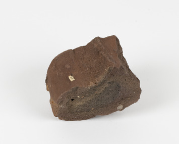
Geological specimen - Brown coal
... Many of these specimens were sent to research and collecting organisations across Australia, including the Burke Museum, to educate and encourage further study. burke museum beechworth indigo shire beechworth museum geological geological specimen mineralogy brown coal brown coal specimen lignite lal lal lal lal coal mine lal lal iron mine ballarat blast furnace A hand-sized light-weight, soft and combustable sedimentary rock specimen, that is dark brown in colour. The specimen has jagged edges, as though parts of the rock have crumbled away. Brown coal, or Lignite, is formed naturally from compressed peat, and is typically found in natural basins. The stages to the formation ...This particular specimen was recovered from the Lal Lal Coal and Iron Mine in Victoria, 19km from Ballarat. Brown Coal was discovered here in 1857, just alongside the Geelong to Ballarat Railway line. This discovery of lignite (brown coal) was the first in Victoria, which would bring important benefits to the region and state, both of which had previously been reliant on coal imports. In the 1860s, iron ore was found just 5km from Lal Lal, and the area was converted into an Iron Ore Mine. The Lal Lal Iron Mining Company took over operations in 1874, who then peaked iron production in 1884. This mine continued operations until June 1884, when the blast furnace was extinguished and never recommenced. The blast furnace at Lal Lal is considered one of the most important and highly significant sites ion early industrial history in Australia, as it is the only remaining best furnace from the nineteenth century in the Southern Hemisphere. The furnace ruins are 17 metres high, and are clearly visible today on Iron Mine Road, Lal Lal, near the Bungal Dam. This specimen of Lignite (brown coal) is significant, as it was mined from the area where brown coal was first discovered in Victoria, leading to an important and controversial future of the mining and use of brown coal in this State. The Victorian Heritage Database has listed the Lal Lal Coal Mine with local significance, with their Statement of Significance stating: "The Lal Lal coal mine is historically significant as the site of the first discovery of lignite (brown coal) in Victoria, and one that promised important benefits to regional and state industries that were reliant on coal imports at the time. The significance of the stie is reduced by the poor state of preservation of the coal mining and processing fabric". This specimen is part of a larger collection of geological and mineral specimens collected from around Australia (and some parts of the world) and donated to the Burke Museum between 1868-1880. A large percentage of these specimens were collected in Victoria as part of the Geological Survey of Victoria that begun in 1852 (in response to the Gold Rush) to study and map the geology of Victoria. Collecting geological specimens was an important part of mapping and understanding the scientific makeup of the earth. Many of these specimens were sent to research and collecting organisations across Australia, including the Burke Museum, to educate and encourage further study.A hand-sized light-weight, soft and combustable sedimentary rock specimen, that is dark brown in colour. The specimen has jagged edges, as though parts of the rock have crumbled away. Brown coal, or Lignite, is formed naturally from compressed peat, and is typically found in natural basins. The stages to the formation of coal ('coalification') begin with plant material and wood, which will decay if it is not subjected to deep burial or heating, and turn into Peat. Peat, when sufficiently compressed naturally, will turn into Brown Coal (Lignite), and finally into Black Coal (sub-bituminous, bituminous and anthracite). Each successive stage has a higher energy content and lower water content. It is brownish-black in colour. Brown Coal has a high moisture content, between 50 and 75 percent, and a low carbon content. Some Brown Coals may be stratified, with layers of plant matter, which means little coalification has occurred beyond the peat natural processing stage. When Brown Coal is submerged in dilute nitric acid or boiling potassium hydroxide solution, it reacts to produce a reddish solution, of which higher-ranked coals do not. When brown coal is pulverised and burned in boilers, the steam is used to drive turbines, which generates electricity. It is the lowest rank of coal, as when burned, it creates a relatively low heat content, which in turn does not create a great output of steam. burke museum, beechworth, indigo shire, beechworth museum, geological, geological specimen, mineralogy, brown coal, brown coal specimen, lignite, lal lal, lal lal coal mine, lal lal iron mine, ballarat, blast furnace -
 The Beechworth Burke Museum
Geological specimen - Ropy Lava
... formations to be created out of the motion. Ropy Lava is a flow that has a hardened crust with molten material underneath, the tension between these states is what creates its characteristic form. The brown/red hue of the stone is an indication of age, as it is oxidised iron deposits. This rock deposit is thought to be sourced from the area by Talbot, in western Victoria. This area has a rich mineral history and experienced the gold rush in the 1850's. The traditional owners of this area are the Dja Dja Wurrung people. This geological ...‘Ropy lava’ is known for its sculptural and layered qualities. It occurs in specific lava flows that are slow moving and slow cooling, allowing for unique formations to be created out of the motion. Ropy Lava is a flow that has a hardened crust with molten material underneath, the tension between these states is what creates its characteristic form. The brown/red hue of the stone is an indication of age, as it is oxidised iron deposits. This rock deposit is thought to be sourced from the area by Talbot, in western Victoria. This area has a rich mineral history and experienced the gold rush in the 1850's. The traditional owners of this area are the Dja Dja Wurrung people.This geological specimen shows the conditions in which the Australian landscape was created as well as provides an indication as to how these events occurred. It is representative of a common natural process that contextualises the formation of Australia with the formation of other landmasses. This specimen is part of a larger collection of geological and mineral specimens collected from around Australia (and some parts of the world) and donated to the Burke Museum between 1868-1880. A large percentage of these specimens were collected in Victoria as part of the Geological Survey of Victoria that begun in 1852 (in response to the Gold Rush) to study and map the geology of Victoria. Collecting geological specimens was an important part of mapping and understanding the scientific makeup of the earth. Many of these specimens were sent to research and collecting organisations across Australia, including the Burke Museum, to educate and encourage further study.Hand sized specimen in brown/red hues42 / victoria, talbot, lava, ropy, ropy lava, mineral, geological specimen, geological, geological heritage, natural stone, natural history -
 The Beechworth Burke Museum
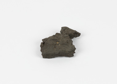
Geological specimen - Brown Coal
... formation the Brown Coal starts as peats, which is an acidic brown deposit resembling soil, and over time when subjected to pressure and heat these peats form the Coal. Brown Coal is the lowest rank of coal as it has a low carbon (energy) content, and a high moisture content. This high moisture content makes Brown Coal unsuitable for overseas exports. This particular specimen was recovered from the Yallourn Mine in Latrobe Valley, Victoria as part of the geological...formation the Brown Coal starts as peats, which is an acidic brown deposit resembling soil, and over time when subjected to pressure and heat these peats form the Coal. Brown Coal is the lowest rank of coal as it has a low carbon (energy) content, and a high moisture content. This high moisture content makes Brown Coal unsuitable for overseas exports. This particular specimen was recovered from the Yallourn Mine in Latrobe Valley, Victoria as part of the geological ...Brown Coal is typically found as rocks. During formation the Brown Coal starts as peats, which is an acidic brown deposit resembling soil, and over time when subjected to pressure and heat these peats form the Coal. Brown Coal is the lowest rank of coal as it has a low carbon (energy) content, and a high moisture content. This high moisture content makes Brown Coal unsuitable for overseas exports. This particular specimen was recovered from the Yallourn Mine in Latrobe Valley, Victoria as part of the geological survey of Victoria being carried out by Alfred Selwyn. Otherwise known as the 'Yallourn Power Station', the Yallourn Mine is Australia's second largest mine. Yallourn Mine was first built in 1920, and since then it has been providing over 1 billion tonnes of Brown Coal to Australia every year. The Yallourn Mine is responsible for 22% of Victoria's electricity and 8% of Australia's electricity. As of 2021 the mine employs around 500 people. Due to ongoing maintenance issues and Australia's move to cleaner energy, the Yallourn Mine intends to shut down permanently as of 2028. Soon after gold was discovered in 1851, Victoria’s Governor La Trobe wrote to the Colonial Office in London, urging ‘the propriety of selecting and appointing as Mineral Surveyor for this Colony a gentleman possessed of the requisite qualifications and acquaintance with geological science and phenomena’. Alfred Selwyn was appointed geological surveyor in Australia in 1852 which began the Geological Survey of Victoria. In 1853-69 the Geological Survey issued under Selwyn's direction sixty-one geological maps and numerous reports; they were of such high standard that a writer in the Quarterly Journal of the Geological Society of London bracketed the survey with that of the United States of America as the best in the world. During his years spent in Australia, Selwyn collected numerous significant geological specimens, examples of which are held in collections such as the Burke Museum.Brown coal is considered to be an essential rock to Australia's energy consumption. Although plentiful in sources, Brown Coal is not able to be exported overseas due to its high moisture content. As Australia moves towards cleaner energy, Brown Coal is going become less used. This specimen is part of a larger collection of geological and mineral specimens collected from around Australia (and some parts of the world) and donated to the Burke Museum between 1868-1880. A large percentage of these specimens were collected in Victoria as part of the Geological Survey of Victoria that begun in 1852 (in response to the Gold Rush) to study and map the geology of Victoria. Collecting geological specimens was an important part of mapping and understanding the scientific makeup of the earth. Many of these specimens were sent to research and collecting organisations across Australia, including the Burke Museum, to educate and encourage further study.A solid hand-sized sedimentary rock that is a dark shade of brown.13 / BROWN COAL / Showing Woody structure / Locality: Yallourn, Vic. | Label probably / correct but / can't find reference / no. 13 to match in / registers. / C Willman / 15/4/21burke museum, beechworth, indigo shire, beechworth museum, geological, geological specimen, mineralogy, yallourn, yallourn mine, victoria, coal, brown coal, brown coal specimen, alfred selwyn, geological survey of victoria, geological survey, yallourn power station -
 The Beechworth Burke Museum
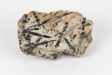
Geological specimen - Tourmaline in Quartz, Unknown
... This item is significant as an example of its type of gemstone and the geological processes leading to its formation. Geological Specimen geology Geology Collection Burke Museum Beechworth indigo shire north-east victoria tourmaline quartz boron crystals minerals gemstones semi-precious black schoalou zchorlau schorl Existing label: Black Schoalou / Tourmaline in / quartz. / Tourmalines XIs have / been fractured and / rehealed with / quartz / C. ...Tourmaline specimens are members of a crystalline silicate mineral group based on boron but influenced by elements including aluminium, iron, magnesium, sodium, lithium, or potassium. Specimens present a wide variety of colours and forms according to the specific mix of these elements. Tourmalines are semi-precious gemstones with many applications, including commercial jewellery production. The word 'tourmaline' derives from the Sinhalese term for the carnelian or red-shaded specimens, "tōramalli". This specimen has been classified by geologists as 'Black Schoalou/Tourmaline in quartz'. Schoalou may equate to a common black-hued type of Tourmaline associated since around 1400 with mines in Saxony, Germany near a village called Schorl (today's Zchorlau). If this specimen is part of the 'Schorl' species of tourmaline it is a member of the most common group of Tourmalines, a divalent sodium ion influenced group accounting for 95% of specimens. On assessment, it was noted that the crossed lines (XIs) of this tourmaline have been fractured and rehealed by the quartz matrix in which the tourmaline rests. This item is significant as an example of its type of gemstone and the geological processes leading to its formation. A solid medium-sized piece of Black Schoalou/Tourmaline in a cream and peach coloured quartz matrix. Existing label: Black Schoalou / Tourmaline in / quartz. / Tourmalines XIs have / been fractured and / rehealed with / quartz / C. Willman / 15/4/21 /geological specimen, geology, geology collection, burke museum, beechworth, indigo shire, north-east victoria, tourmaline, quartz, boron, crystals, minerals, gemstones, semi-precious, black schoalou, zchorlau, schorl -
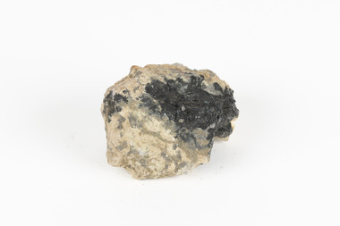
 The Beechworth Burke Museum
Geological specimen - Galena (with quartz), unknown
... Geological Specimen geology Geology Collection Burke Museum Beechworth galena galena quartz quartz Charles Rasp Broken Hill Mining Company BHP group limited BHP Lead Ore lead sulphide Sulphide silver broken hill Existing Label: GALENA / (with quartz) / Locality: Broken Hill / N.S.W 120 x 70 x 29 A flat, hand-sized, grey sulphide specimen that is the natural compound of lead with a quartz formation on the top surface. ...Galena is the natural compound of lead and classed as a sulphide, it crystallises in a cubic pattern and its chemical formula is PbS. Galena is a primary source of both lead and silver. This specimen of Galena comes from Broken Hill. Broken Hill has one of the world’s largest and most significant deposit of ore for the production of lead. Mining of Galena at Broken Hill began with the staking of land by Charles Rasp in 1883. By the following year, in 1884, Rasp and six others had formed Broken Hill Mining Company. Broken Hill Mining Company eventually evolved into BHP group limited and is currently the largest mining company in the world and the largest company in Australia. There is archaeological evidence from artefacts discovered in Turkey that humans have been extracting lead from galena by the process of smelting since at least 6500 BCE. This specimen also has quartz on the top surface which is frequently discovered alongside Galena. This mineral specimen is of historic significance as a sample of Galena extracted from Broken Hill during the 19th century. Mining for Galena in Broken Hill begin in 1883 by Charles Rasp and evolved into the world’s largest mining company – BHP Group Limited. Broken Hill is one of the world’s most significant deposits of ore for the production of lead. This specimen is part of a larger collection of geological and mineral specimens collected from around Australia (and some parts of the world) and donated to the Burke Museum between 1868-1880. A large percentage of these specimens were collected in Victoria as part of the Geological Survey of Victoria that begun in 1852 (in response to the Gold Rush) to study and map the geology of Victoria. Collecting geological specimens was an important part of mapping and understanding the scientific makeup of the earth. Many of these specimens were sent to research and collecting organisations across Australia, including the Burke Museum, to educate and encourage further study.A flat, hand-sized, grey sulphide specimen that is the natural compound of lead with a quartz formation on the top surface. Existing Label: GALENA / (with quartz) / Locality: Broken Hill / N.S.W 120 x 70 x 29geological specimen, geology, geology collection, burke museum, beechworth, galena, galena quartz, quartz, charles rasp, broken hill mining company, bhp group limited, bhp, lead, ore, lead sulphide, sulphide, silver, broken hill -
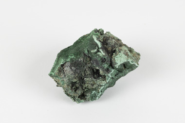 The Beechworth Burke Museum
Geological specimen - Malachite, Unknown
... formation of carbonate minerals can occur. It is a substance that can be found in many different parts of the world including: Australia, USA, Russia and the Democratic Republic of Congo. Malachite has historically been used to produce copper, with mining of the mineral dating back over a period of four thousand years. Due to its beautiful green colourations, it is also commonly used for aesthetic purposes such as in the production of sculptures and jewellery. This particular specimen was collected from the town of Burra, South Australia as part of a geological...formation of carbonate minerals can occur. It is a substance that can be found in many different parts of the world including: Australia, USA, Russia and the Democratic Republic of Congo. Malachite has historically been used to produce copper, with mining of the mineral dating back over a period of four thousand years. Due to its beautiful green colourations, it is also commonly used for aesthetic purposes such as in the production of sculptures and jewellery. This particular specimen was collected from the town of Burra, South Australia as part of a geological ...Malachite is a copper carbonate hydroxide mineral. It has a chemical composition of Cu2(CO3)(OH)2. It often forms within limestone where a subsurface chemical environment favourable for the formation of carbonate minerals can occur. It is a substance that can be found in many different parts of the world including: Australia, USA, Russia and the Democratic Republic of Congo. Malachite has historically been used to produce copper, with mining of the mineral dating back over a period of four thousand years. Due to its beautiful green colourations, it is also commonly used for aesthetic purposes such as in the production of sculptures and jewellery. This particular specimen was collected from the town of Burra, South Australia as part of a geological survey undertaken during the nineteenth century. The locality (located on Ngadjuri Country) has a long history of mining, particularly in copper mining, as the area is rich in copper deposits. The first significant discovery of this was made in Burra (Burra Burra Mine) in 1845 and, at the time, the mine was the largest and richest of its kind in the world, producing nearly five percent of the total world copper output. This specimen is significant as it is considered to be a rare gemstone, as many of the original deposits for the stones are significantly depleted, leaving behind very few sources. This specimen is part of a larger collection of geological and mineral specimens collected from around Australia (and some parts of the world) and donated to the Burke Museum between 1868-1880. A large percentage of these specimens were collected in Victoria as part of the Geological Survey of Victoria that begun in 1852 (in response to the Gold Rush) to study and map the geology of Victoria. Collecting geological specimens was an important part of mapping and understanding the scientific makeup of the earth. Many of these specimens were sent to research and collecting organisations across Australia, including the Burke Museum, to educate and encourage further study.A solid palm-sized copper carbonate hydroxide mineral with patterns of green colourations Existing Label: MALACHITE / Locality: Burra / S. Aust. Other Label: Confirmed / as Malachite / C. Willman / 15/4/1 / + Bill Birch burke museum, beechworth, geological, geological specimen, malachite, gemstone, green gemstone, burra, burra burra mine, burra south australia, carbonate mineral, copper, copper mining, copper mining burra, carbonate hydroxide mineral, copper carbonate, malachite mining, malachite burra, monster mine -
 The Beechworth Burke Museum
Geological specimen - Tourmaline (schorl), Unknown
... They offer insights into the geological processes and mineral formation in the region, contributing to a better understanding of Earth's geological history. burke museum beechworth indigo shire geological geological specimen mineralogy tourmaline TOURMALINE (schorl) / (Silicate of boron and aluminum) A hand-sized solid mineral specimen in shades of brown, green, light grey and dark grey Geological specimen Tourmaline (schorl) ...Tourmaline is a group of minerals belonging to the complex borosilicate mineral class. These minerals are known for their striking and varied colours, making them prized gemstones. Tourmaline crystals can come in various shades, including pink, green, blue, brown, black, and colourless. They are often transparent or translucent. Tourmaline's chemical composition is complex, but it typically includes elements such as aluminium, iron, magnesium, sodium, lithium, and potassium. The specific arrangement of these elements in the crystal lattice gives rise to the different colours and properties of tourmaline specimens. Tourmaline specimens from Beechworth, Victoria, Australia, are a notable part of the region's mineral heritage. These tourmalines are of interest to mineral collectors and enthusiasts. While the tourmaline found in Beechworth is not as well-known as some other tourmaline varieties, it has unique characteristics and a historical context associated with the gold mining areas in Beechworth.The significance of tourmaline in Beechworth, Victoria, Australia, lies in its unique geological and historical context, contributing to both scientific and cultural aspects. The tourmaline mined in Beechworth is a rare and unique variety of tourmaline that is primarily found in the historic gold mining areas surrounding Beechworth. Its occurrence is closely linked to the geological processes that shaped the region during the Gold Rush era. The discovery of tourmaline in Beechworth adds to the rich mineral heritage of the area, which was historically known for gold mining. The specimens serve as a tangible connection to the region's mining history and contribute to preserving its geological legacy. The presence of tourmaline in Beechworth showcases the mineralogical diversity of the area. Tourmaline is known for its wide range of colours and unique properties, making it a valuable subject of study for mineralogists and geologists. Tourmaline specimens from Beechworth have educational significance, providing opportunities for research and study. They offer insights into the geological processes and mineral formation in the region, contributing to a better understanding of Earth's geological history.A hand-sized solid mineral specimen in shades of brown, green, light grey and dark greyTOURMALINE (schorl) / (Silicate of boron and aluminum) burke museum, beechworth, indigo shire, geological, geological specimen, mineralogy, tourmaline -
 Phillip Island and District Historical Society Inc.
Photograph
... Phillip Island and District Historical Society Inc. phillip-island-and-the-bass-coast One of a collection of over 400 photographs in an album commenced in 1960 and presented to the Phillip Island & Westernport Historical Society by the Shire of Phillip Island local history photography basalt jetty surf beach black & white photograph coastline geology rock formations John Jenner Bryant West Photograph of the basalt Jetty and geological feature near Surf Beach Photograph Bryant West ...One of a collection of over 400 photographs in an album commenced in 1960 and presented to the Phillip Island & Westernport Historical Society by the Shire of Phillip IslandPhotograph of the basalt Jetty and geological feature near Surf Beachlocal history, photography, basalt jetty, surf beach, black & white photograph, coastline, geology, rock formations, john jenner, bryant west -
 Bendigo Historical Society Inc.
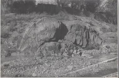
Photograph - Napoleon Anticline, 1935
... geology, an anticline is a type of fold that is an arch-like shape and has its oldest beds at its core, whereas a syncline is the inverse of an anticline. A typical anticline is convex up in which the hinge or crest is the location where the curvature is greatest, and the limbs are the sides of the fold that dip away from the hinge. Significant to mining history of Bendigo. Napoleon Gold Mine anticline Written in pencil on back of photograph : 'Napoleon anticline Golden Square'. Black and white photograph: rock formation ...In structural geology, an anticline is a type of fold that is an arch-like shape and has its oldest beds at its core, whereas a syncline is the inverse of an anticline. A typical anticline is convex up in which the hinge or crest is the location where the curvature is greatest, and the limbs are the sides of the fold that dip away from the hinge.Significant to mining history of Bendigo.Black and white photograph: rock formation, anticline with an archlike shape in centre of image. Written in pencil on back of photograph : 'Napoleon anticline Golden Square'.napoleon gold mine, anticline -
Bendigo Historical Society Inc.
Map - MAP: VIRGINIA MINE GARDEN GULLY LINE OF REEF
... Key shows types of formations - quartz, spurs, sandstone, slate, cleavage, lava. This map forms part of the Geological Survey of Victoria, Structure of Bendigo Goldfield report, No. 47, 1923. ...Geological Survey Office, Bendigo. Map of Virginia Mine on the Garden Gully line of reef, Eaglehawk, transverse section. Shaft, levels and Garden Gully anticlinal axial line drawn. Key shows types of formations ...Map of Virginia Mine on the Garden Gully line of reef, Eaglehawk, transverse section. Shaft, levels and Garden Gully anticlinal axial line drawn. Key shows types of formations - quartz, spurs, sandstone, slate, cleavage, lava. This map forms part of the Geological Survey of Victoria, Structure of Bendigo Goldfield report, No. 47, 1923. H.Herman, late Director of Geological Survey.Geological Survey Victoria, Geological Survey Office, Bendigo.bendigo, gold mining, virgina mine eaglehawk, eaglehawk, bendigo, gold mining, virginia mine, garden gully line of reef. -
 Bendigo Historical Society Inc.
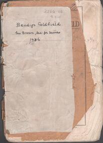
Booklet - Albert Richardson Collection: Bendigo Goldfield, MInes Department, Victoria 1936, 1936
... formation, sill heights and area of claim. Fifty one page booklet. On front page: Bendigo Goldfield, issued by Geo Brown, Secretary for Mines, under the authority of The Hon. E.J. Hogan, M.L.A., Minister of Mines. Mines Department, Melbourne, Victoria, Australia, 1936.Content includes: historical information; recent development and future prospects, geology and lines of reef. ...Albert Richardson was an expert on the history of the Bendigo Goldfield. The Albert Richardson Park at Victoria Hill, is named in his honour. He was a prominent member of the Bendigo Historical Society. Fifty one page booklet. On front page: Bendigo Goldfield, issued by Geo Brown, Secretary for Mines, under the authority of The Hon. E.J. Hogan, M.L.A., Minister of Mines. Mines Department, Melbourne, Victoria, Australia, 1936.Content includes: historical information; recent development and future prospects, geology and lines of reef. Reef lines described are: Tysons, Lightning Hill, Hustlers, Derby, Paddy's Gully, Garden Gully, Deborah, Sheepshead, New Chum, Nell Gwynne, British and Foreign, Napoleon, Lancashire, Carshalton, Thistle, Christmas and Birds. On front cover 'Bendigo Goldfield, Geo Brown, Sec. for Mines, 1936' written in black pen. On first page 'A.Richardson, 29 Harrison Street, Bendigo' The booklet is annotated throughout by Albert Richardson, for example, the mines along the New Chum Line are further described with their date of formation, sill heights and area of claim.albert richardson, gold mining, goldfield, reef lines, 1936, mines department -
 Bendigo Historical Society Inc.
Document - MINING REPORTS - GEOLOGICAL REPORT OF MAIN SECTION OF GOLDFIELD
... Geological report of main section in a length of 5 miles. Report mentions sandstones and slates, with occasional calcareous bands, which show a cyclic arrangement. Also mentioned are different zones of sediments, anticlines, structure of the field and references: Page 1028 Formation of Bendigo Quartz Reefs by F R Stilwell to 1032 and pages 160 to 163 'Ore deposits as Related to Structural Features - A H Newhouse. ...History House 11 Mackenzie Street Bendigo goldfields DOCUMENT Gold mining reports Mining Reports Geological Report of Main Section of Goldfield The Bendigo Goldfields Page 1015 Formation of Bendigo Quartz Reefs by F R Stilwell Page 1028 to 1032 Ore Deposits as Related to Structural Features Pages 160 to 163 A H Newhouse Handwritten notes by Albert Richardson, with typed copy, on a Geological report of main section in a length of 5 miles. ...Handwritten notes by Albert Richardson, with typed copy, on a Geological report of main section in a length of 5 miles. Report mentions sandstones and slates, with occasional calcareous bands, which show a cyclic arrangement. Also mentioned are different zones of sediments, anticlines, structure of the field and references: Page 1028 Formation of Bendigo Quartz Reefs by F R Stilwell to 1032 and pages 160 to 163 'Ore deposits as Related to Structural Features - A H Newhouse. document, gold, mining reports, mining reports, geological report of main section of goldfield, the bendigo goldfields page 1015, formation of bendigo quartz reefs by f r stilwell page 1028 to 1032, ore deposits as related to structural features pages 160 to 163 a h newhouse -
 Bendigo Historical Society Inc.
Document - VICTORIA HILL - SUGGESTED WORDING OF SIGNS FOR VICTORIA HILL
... History House 11 Mackenzie Street Bendigo goldfields DOCUMENT Gold victoria hill Victoria Hill Suggested Wording of Signs for Victoria Hill The North Old Chum Mine Ballerstedt's First Open Cut Lansell's Big 180 Crushing Battery The Victoria Quartz Coloured rock formations Great Central Victoria Wittscheibe's 'Jewellers Shop' Luffsman & Sterry's Claim The Adventure Handwritten carbon copy of suggested wording for signs at Victoria Hill. Mentions mines and open cuts and amounts of gold, and geological ...Handwritten carbon copy of suggested wording for signs at Victoria Hill. Mentions mines and open cuts and amounts of gold, and geological features. Notes prepared by Albert Richardson.document, gold, victoria hill, victoria hill, suggested wording of signs for victoria hill, the north old chum mine, ballerstedt's first open cut, lansell's big 180, crushing battery, the victoria quartz, coloured rock formations, great central victoria, wittscheibe's 'jewellers shop', luffsman & sterry's claim, the adventure -
Glenelg Shire Council Cultural Collection
Photograph - Photograph - Princess Margaret Rose Caves, n.d
... Glenelg Shire Council Cultural Collection History House Cliff Street Portland great-ocean-road Princess Margaret Rose Caves geology tourism Coloured photograph showing stalactite and helictite formations in Princess Margaret Rose Caves. ...Coloured photograph showing stalactite and helictite formations in Princess Margaret Rose Caves.princess margaret rose caves, geology, tourism -
 Greensborough Historical Society
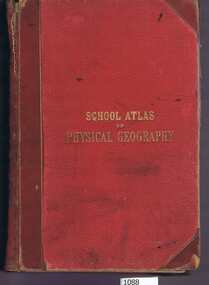
Book, W. & A.K. Johnston, School atlas of physical geography: the elementary facts of geology; hydrography; meteorology and natural history by Alex Keith Johnston, 1871_
... formations. This volume illustrates a 19th century view of physical geography. physical geography school books atlases Inscribed on fly leaf with original owner's name (1890) 51 pages, 20 plates, maps. Red hard cover with title in gold lettering. School atlas of physical geography: the elementary facts of geology ...This atlas of physical geography has 20 plates illustrating maps and various rock formations.This volume illustrates a 19th century view of physical geography.51 pages, 20 plates, maps. Red hard cover with title in gold lettering.Inscribed on fly leaf with original owner's name (1890)physical geography, school books, atlases -
 Federation University Historical Collection
Book, Memoirs of the Geological Survey of Victoria No 14 The Ballarat Goldfields, 1923, 1923
... Contents include topography, physiography, historical, geology, basalt, faults, dykes, minerals leads, alluvial mines, nuggets, structure of Ballarat West goldfields, structure of Ballarat East gold-field, quartz formation, indicators, defunct mines, existing mines, table of deepest shafts. ...Contents include topography, physiography, historical, geology, basalt, faults, dykes, minerals leads, alluvial mines, nuggets, structure of Ballarat West goldfields, structure of Ballarat East gold-field, quartz formation, indicators, defunct mines, existing mines, table of deepest shafts. ...William Baragwanath was educated at the Ballarat School of Mines, obtaining a Geology Certificate in 1911. After further study he went on the become Secretary for Mines, and Chief Mining Surveyor. Baragwanath was a Councillor of the Ballarat School of Mine from 1916 to 1950.Pink covered foolscap book of 257 pages and 32 maps and plans by William Baragwanath. Contents include topography, physiography, historical, geology, basalt, faults, dykes, minerals leads, alluvial mines, nuggets, structure of Ballarat West goldfields, structure of Ballarat East gold-field, quartz formation, indicators, defunct mines, existing mines, table of deepest shafts. Images include: section of the Ballarat Gold-Field, Dead HOrse Flat, lakes formed by Basalt Flows, Gong Gong Creek, Frenchman's Lead, Ballarat West Mines, LEases and positions of shafts (1857), puddling, White Horse Lead, Woah Hawp Canton, Ballarat Township mines, Sebastopol, syncline, Victoria United Line, First Chance Mine, Llanberris No 1 Mine, Saddle Reef, New Normanby Mine, Woah Hawp Canton Mine, South Star Mine, Sebastopol Plateau, south Woah Hawp Mine, Woah No. 2 Minegeology, geological survey no 14, ballarat, baragwanath, william baragwanath