Showing 390 items matching "geology of victoria"
-
 Bendigo Historical Society Inc.
Map - GEOLOGICAL MAP OF BENDIGO GOLD FIELD
... This map forms part of the Geological Survey of Victoria, Structure of Bendigo Goldfield report, No. 47, 1923. ...Geological Survey Victoria...This map forms part of the Geological Survey of Victoria, Structure of Bendigo Goldfield report, No. 47, 1923. ...Map of Bendigo gold field showing anticlines, synclines, shaft, alluvial deposits and contour lines. Map is in two sections. This map forms part of the Geological Survey of Victoria, Structure of Bendigo Goldfield report, No. 47, 1923. H.Herman, late Director of Geological Survey.Geological Survey Victoriabendigo, gold mining, geological map -
Bendigo Historical Society Inc.
Map - BENDIGO GOLD FIELD LONGITUDINAL VERTICAL PROJECTIONS
... This map forms part of the Geological Survey of Victoria, Structure of Bendigo Goldfield report, No. 47, 1923. ...Geological Survey Victoria...This map forms part of the Geological Survey of Victoria, Structure of Bendigo Goldfield report, No. 47, 1923. ...Bendigo gold field map showing vertical projections of portions of three anticlinal axial planes showing stratigraphical zones and caps of known saddle reefs. This map forms part of the Geological Survey of Victoria, Structure of Bendigo Goldfield report, No. 47, 1923. H.Herman, late Director of Geological Survey.Geological Survey Victoriabendigo, gold mining, vertical projections, bendigo, goldfield, gold mining, reef lines, mining companies, geological survey -
Bendigo Historical Society Inc.
Map - BENDIGO GOLD FIELD GEOLOGICAL MAP, 1923
... This map forms part of the Geological Survey of Victoria, Structure of Bendigo Goldfield report, No. 47, 1923. ...Geological Survey Victoria...History House 11 Mackenzie Street Bendigo goldfields BENDIGO Gold mining geological map Geological Survey Victoria Geological map of the Bendigo Gold Field showing stratigraphical zones. ...Geological map of the Bendigo Gold Field showing stratigraphical zones. Map in two sections, colour coded showing anticlines, synclines, shafts, fault lines, fossils. Signed by H. Herman. This map forms part of the Geological Survey of Victoria, Structure of Bendigo Goldfield report, No. 47, 1923. H.Herman, late Director of Geological Survey.Geological Survey Victoriabendigo, gold mining, geological map -
Bendigo Historical Society Inc.
Map - BENDIGO GOLD FIELD GEOLOGICAL MAP
... This map forms part of the Geological Survey of Victoria, Structure of Bendigo Goldfield report, No. 47, 1923. ...Geological Survey Victoria...History House 11 Mackenzie Street Bendigo goldfields BENDIGO Gold mining geological map Geological Survey Victoria Geological map of the Bendigo Gold Field showing stratigraphical zones. ...Geological map of the Bendigo Gold Field showing stratigraphical zones. Map in two sections, colour coded showing anticlines, synclines, shafts, fault lines, fossils. Signed by H. Herman. This map forms part of the Geological Survey of Victoria, Structure of Bendigo Goldfield report, No. 47, 1923. H.Herman, late Director of Geological Survey.Geological Survey Victoriabendigo, gold mining, geological map -
 The Beechworth Burke Museum
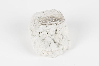
Geological specimen - Kaolin, unknown
... ...geology of victoria...This survey helped map and study the geology of Victoria. In Victoria, Kaolin is particularly used as a filler and coating material in paper manufacture. ...This survey helped map and study the geology of Victoria. In Victoria, Kaolin is particularly used as a filler and coating material in paper manufacture. ...Kaolin is also known as china clay. This specimen came from Dunolly, Victoria and was donated to the Museum in 1868 as part of the Geological Survey of Victoria. This survey helped map and study the geology of Victoria. In Victoria, Kaolin is particularly used as a filler and coating material in paper manufacture. It can also be used in paints, ceramics, rubbers and plastics. There are many kaolin deposits in Victoria but many of these have been mined out and there is not much Kaolin left. Rocks that have a high amount of Kaolinite and it can be formed through the decomposition of other materials. There are two types of Kaolin; hard and soft kaolin. Soft kaolin's are coarse but have a soapy texture. It can also break easily. The hard kaolins have an earthly texture and are finer grained. This means that they are harder to break, unlike the soft kaolin. Hard kaolin's are formed by flocculation in salt water, a process that in basic terms, bonds particles together. Kaolin is a common material in Victoria and that is why it is significant. While this specimen was mined in Dunolly, Victoria Kaolin can also be found Pittong, Pakenham, Bulla, Hallam and Ballarat as well as many other places throughout Victoria. This specimen represents the presence of Kaolin deposits in this region of Australia. It is also significant because Kaolin has many uses and is largely beneficial to many manufacturing processes in Victoria. This specimen is part of a larger collection of geological and mineral specimens collected from around Australia (and some parts of the world) and donated to the Burke Museum between 1868-1880. A large percentage of these specimens were collected in Victoria as part of the Geological Survey of Victoria that begun in 1852 (in response to the Gold Rush) to study and map the geology of Victoria. Collecting geological specimens was an important part of mapping and understanding the scientific makeup of the earth. Many of these specimens were sent to research and collecting organisations across Australia, including the Burke Museum, to educate and encourage further study.Two pieces of Kaolinite mineral with shades of white and graygeological specimen, geology, geology collection, burke museum, beechworth, kaolin, china clay, dunolly, geological survey of victoria, kaolinite, victoria, mining, mining deposits, geology of victoria, australia, filler, coating material, paper manufacture, paint, ceramics, rubbers, plastics, decomposition, materials, soft kaolin, hard kaolin, flocculation, particles, salt water -
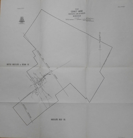
Bendigo Historical Society Inc.
Map - MAP: VIRGINIA MINE GARDEN GULLY LINE OF REEF
... This map forms part of the Geological Survey of Victoria, Structure of Bendigo Goldfield report, No. 47, 1923. ...Geological Survey Victoria, Geological Survey Office, Bendigo....This map forms part of the Geological Survey of Victoria, Structure of Bendigo Goldfield report, No. 47, 1923. ...Map of Virginia Mine on the Garden Gully line of reef, Eaglehawk, transverse section. Shaft, levels and Garden Gully anticlinal axial line drawn. Key shows types of formations - quartz, spurs, sandstone, slate, cleavage, lava. This map forms part of the Geological Survey of Victoria, Structure of Bendigo Goldfield report, No. 47, 1923. H.Herman, late Director of Geological Survey.Geological Survey Victoria, Geological Survey Office, Bendigo.bendigo, gold mining, virgina mine eaglehawk, eaglehawk, bendigo, gold mining, virginia mine, garden gully line of reef. -
Clunes Museum
Book, ROBERT S. BRAIN, BULLETINS OF THE GEOLOGICAL SURVEY OF VICTORIA, 1903
... DEPARTMENT OF MINES, GEOLOGICAL SURVEY OF VICTORIA...BOOK - BULLETINS OF THE GEOLOGICAL SURVEY OF VICTORIA.. NO. 6 THE CLUNES GOLDFIELD BY W M. ...DEPARTMENT OF MINES, GEOLOGICAL SURVEY OF VICTORIA local history mining GEOLOGICAL SURVEY BULLETINS OF THE GEOLOGICAL SURVEY OF VICTORIA, AUSTRALIA. ...BULLETINS OF THE GEOLOGICAL SURVEY OF VICTORIA, AUSTRALIA.BOOK - BULLETINS OF THE GEOLOGICAL SURVEY OF VICTORIA.. NO. 6 THE CLUNES GOLDFIELD BY W M. BRADFORD.non-fictionBULLETINS OF THE GEOLOGICAL SURVEY OF VICTORIA, AUSTRALIA.local history, mining, geological survey -
Bendigo Historical Society Inc.
Document - STRUCTURE OF BENDIGO GOLDFIELD BULLETIN NO. 47
... On front of booklet : 1923 Victoria, Department of Mines, Bulletins of the Geological Survey of Victoria, W. ...Geological Survey of Victoria...On front of booklet : 1923 Victoria, Department of Mines, Bulletins of the Geological Survey of Victoria, W. ...Booklet, 36 pages, that describes the structure of the Bendigo Goldfield. Booklet is enclosed in an envelope. On front of booklet : 1923 Victoria, Department of Mines, Bulletins of the Geological Survey of Victoria, W. Baragwanath, Director. Structure of Bendigo Goldfield, by H. Herman, late Director of Geological Survey. Maps under catalogue number 3769 accompanied the booklet and are listed as 'plates' on the contents page. Plans and Sections to accompany Bulletin No 47, Structure of Bendigo Gold-Field, by H Herman, B.C.E., M.M.E., F.G.S., late Director of Geological Survey.Geological Survey of Victoriabendigo, gold mining, structure of goldfield, bendigo, goldfield, gold mining, geology -
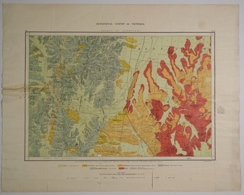
University of Melbourne, Burnley Campus Archives
Map - Geological map, Melbourne and Suburbs, 1959
... geology...Geological Survey of Victoria...Geological map of Melbourne, 1959, modified by officers of the Geological Survey of Victoria, from earlier geological surveys. ...University of Melbourne, Burnley Campus Archives 500 Yarra Boulevard Richmond melbourne Melbourne metropolitan area geology Geological Survey of Victoria Department of Mines Geological map of Melbourne, 1959, modified by officers of the Geological Survey of Victoria, from earlier geological surveys. ...Geological map of Melbourne, 1959, modified by officers of the Geological Survey of Victoria, from earlier geological surveys. Scale 1:31.680melbourne metropolitan area, geology, geological survey of victoria, department of mines -
Bendigo Historical Society Inc.
Map - BENDIGO GOLDFIELD VERTICAL PROJECTIONS
... This map forms part of the Geological Survey of Victoria, Structure of Bendigo Goldfield report, No. 47, 1923. ...Geological Survey of Victoria...This map forms part of the Geological Survey of Victoria, Structure of Bendigo Goldfield report, No. 47, 1923. ...Map of Bendigo Gold Field in two sections showing 'vertical projections along several anticlinal axial planes showing pitch, stratigraphical zones, faultlines, shafts and etc.'. Bulletin No 47 written top left hand side. Lines of reef described: Christmas line Lancashire line Nell Gwynne line New Chum line Hustlers line Garden Gully line Sheepshead line Mines along the reef lines are listed. This map forms part of the Geological Survey of Victoria, Structure of Bendigo Goldfield report, No. 47, 1923. H.Herman, late Director of Geological Survey. On bottom of second section : Prepared in the Geological Survey Office, Bendigo, under the direction of H. Herman, late Director of Geological Survey, from surveys by H.S. Whitelaw, Field Geologist, assisted by E.S. Usher, A.J.J. Moore and R.A. Keble.Geological Survey of Victoriabendigo, gold mining, reef lines -
Bendigo Historical Society Inc.
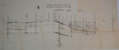
Map - SECTIONS ACROSS BENDIGO GOLDFIELD
... This map forms part of the Geological Survey of Victoria, Structure of Bendigo Goldfield report, No. 47, 1923. ...Geological Survey of Victoria...This map forms part of the Geological Survey of Victoria, Structure of Bendigo Goldfield report, No. 47, 1923. ...Map in three sections showing sections across Bendigo Gold Field, showing anticlines, synclines, faults, stratigraphical zones and mines along the reef lines. Key shows rock types Castlemaine, Bendigo B1, B2, B3 and B4, and Lancefieldian. First part of map shows sections A-A, B-B and C-C. Reef lines drawn with mines listed: Fault line shown are the Carshalton, Stafford, New Chum, Virginia and Clarence. A datum line shows 600 ft above sea level. On bottom of plan: ' Prepared in the Geological Survey Office, Bendigo, under the direction of H. Herman, late Director of Geological Survey, from surveys by H.S. Whitelaw, Field Geologist, assisted by E.S. Usher, A.J.J. Moore and R.A. Keble.' Second section of map shows sections D-D, and E-E. Fault lines listed are the Tambour Major fault, Carshalton fault, Stafford fault, Nell Gwynne fault, New Chum fault, Deborah fault. Third section shows sections F-F and G-G. Fault lines listed are the Bird Reef fault, Kangaroo Gully fault, Langdon fault, Carshalton fault, Nell Gwynne fault, Spring Gully fault, Hustlers fault, Gravel Hill fault, Ordes fault, Thanet fault. This map forms part of the Geological Survey of Victoria, Structure of Bendigo Goldfield report, No. 47, 1923. H.Herman, late Director of Geological Survey.Geological Survey of Victoriabendigo, gold mining, reef line maps -
 Bendigo Historical Society Inc.
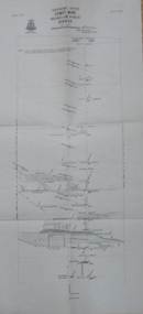
Map - HUSTLERS LINE OF REEFS - LONGITUDINAL SECTION THROUGH THE SADDLE REEFS
... K., United Hustler's & Redan, Old Shaft and Hustler's Consols. Has Geological Survey of Victoria Crest and underneath is: H. ...Geological Survey of Victoria Crest...K., United Hustler's & Redan, Old Shaft and Hustler's Consols. Has Geological Survey of Victoria Crest and underneath is: H. ...Drawing with Longitudinal Section through the Saddle Reefs along portion of Hustler's Line of Reefs, Bendigo. Map shows the depth of the mines, reef numbers and Datum 700 ft above sea level. North and South is also noted on the map. Map signed by H. S, Whitelaw, Underground Survey Office, Bendigo, September 1913. Bulletin No 33, Plate No XXXIV. Bendigo Creek, Ironbark Creek and Long Gully are also noted. Mines are: Fortuna Hustlers, Hustler's Royal Reserve No 2 Main Shaft, Hustler's Royal Reserve No 2 Park Shaft, Royal Hustler's, Imperial Hustler's, Extended Hustler's Freehold, Great Extended Hustler's Tribute (Pups), Old Shaft, Great Extended Hustler's Reef No 2, Great Extended Hustler's Main Shaft, Old Shaft, Hustler's Reef, Hustler's Reef No 1, Comet, K. K., United Hustler's & Redan, Old Shaft and Hustler's Consols. Has Geological Survey of Victoria Crest and underneath is: H. Herman, Director, W. Dickson, Secretary for Mines, The Hon. J Drysdale Brown M L C. Minister of Mines.Geological Survey of Victoria Crestmining, hustler's reef maps, hustlers line of reefs, bendigo creek, royal hustler's, imperial hustler's, extended hustler's freehold, great extended hustler's tribute (pups), great extended hustler's reef no 2, great extended hustler's main shaft, hustler's reef, hustler's reef no 1, united hustler's & redan, old shaft and hustler's consols.h s whitelaw, underground survey office bendigo september 1913 -
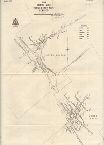
 Bendigo Historical Society Inc.
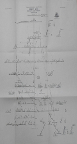
Map - COMET MINE - LONGITUDINAL SECTION COMET MINE
... Geological Survey of Victoria...History House 11 Mackenzie Street Bendigo goldfields MINING Parish Map Hustler's Line of Reef Longitudinal Section of Comet Mine Bulletin No 33 Plate No XXVI H S Whitelaw Geological Survey of Victoria Longitudinal section of the Comet Mine on the Hustler's Line of Reef Bulletin No 33, Plate No XXVI signed by H. ...Longitudinal section of the Comet Mine on the Hustler's Line of Reef Bulletin No 33, Plate No XXVI signed by H. S. Whitelaw, Underground Survey Office Bendigo, September 1913. Map shows datum lines, depths of levels, approximate boundaries and references to other plans. Note - Plates 4, 8, 13, 20, 26 and 31 form a Longitudinal Section from Fortuna Hustler's to Hustler's Consols Mine. Geological Survey of Victoriamining, parish map, hustler's line of reef, longitudinal section of comet mine bulletin no 33 plate no xxvi, h s whitelaw -
 Bendigo Historical Society Inc.
Map - COMET MINE - TRANSVERSE SECTION COMET MINE
... Geological Survey of Victoria...History House 11 Mackenzie Street Bendigo goldfields MINING Hustler's Line of Reefs Transverse Section of Comet Mine Bulletin No 33 Plate No XXV Lightning Hill Line of Reef Geological Survey of Victoria Transverse section of the Comet Mine on the Hustler's Line of Reef Bulletin No 33, Plate No XXV signed by H. ...Transverse section of the Comet Mine on the Hustler's Line of Reef Bulletin No 33, Plate No XXV signed by H. A. Whitdon, Underground Survey Office Bendigo September,1913. Map shows depth of the different levels, the type of stone and shaft about 2020 deep. A number of smaller drawings on the side. Reference explaining the different types of stone, etc. Geological Survey of Victoriamining, hustler's line of reefs, transverse section of comet mine bulletin no 33 plate no xxv, lightning hill line of reef -
 Bendigo Historical Society Inc.
Map - COMET MINE - PLAN OF COMET MINE
... Geological Survey of Victoria...History House 11 Mackenzie Street Bendigo goldfields MINING Parish Map Hustler's Line of Reefs Comet Mine Plan Bulletin No 33 Plate No XXIV Geological Survey of Victoria Plan of the Comet Mine on the Hustler's Line of Reefs Bulletin No 33, Plate No XXIV signed by H S Whitelaw, Underground Survey Office Bendigo, September 1913. ...Plan of the Comet Mine on the Hustler's Line of Reefs Bulletin No 33, Plate No XXIV signed by H S Whitelaw, Underground Survey Office Bendigo, September 1913. Upper and Lower Levels and approximate boundaries shown. Depths shown.Geological Survey of Victoriamining, parish map, hustler's line of reefs, comet mine plan bulletin no 33 plate no xxiv -
 Bendigo Historical Society Inc.
Map - COMET MINE - PLAN OF COMET MINE
... Geological Survey of Victoria...History House 11 Mackenzie Street Bendigo goldfields MINING Hustler's Line of Reefs Comet Line Plan Belletin No 33 Plate No XXIII Lightning Hill Anticline Hustler's Anticline United Hustler's & Redan Co Hustler's Reef Co H S Whitelaw Geological Survey of Victoria Plan of the Comet Mine on the Hustler's Line of Reefs Bulletin No 33, Plate No XXIII. ...Plan of the Comet Mine on the Hustler's Line of Reefs Bulletin No 33, Plate No XXIII. Map shows depths, Lightning Hill Anticline, Hustler's Anticline and approximate Lease Boundary. Signed by H. S. Whitelaw, Underground Survey Office Bendigo, September 1913. United Hustler's & Redan Co and Hustler's Reef Co also named on map. Geological Survey of Victoriamining, hustler's line of reefs, comet line plan belletin no 33 plate no xxiii, lightning hill anticline, hustler's anticline, united hustler's & redan co, hustler's reef co, h s whitelaw -
Stawell Historical Society Inc
Map, Geological Survey of Victoria
... Geological Survey of Victoria...Stawell Historical Society Inc 46 Longfield St Stawell grampians stawell Geological Survey of Victoria Geological Survey of Victoria Map ...Geological Survey of Victoriastawell -
 Bendigo Historical Society Inc.
Map - COUNTY OF GLADSTONE, November 1910
... Map: County of Gladstone, Geological survey of Victoria. Geological map...History House 11 Mackenzie Street Bendigo goldfields MAP Gladstone geological County of Gladstone Geological Map Map: County of Gladstone, Geological survey of Victoria. Geological map Map COUNTY OF GLADSTONE ...Map: County of Gladstone, Geological survey of Victoria. Geological mapmap, gladstone, geological, county of gladstone, geological map -
Clunes Museum
Document - GEOLOGICAL SURVEY, PROFESSOR. J.W.GREGORY, F.R.S, D.SC., DIRECTOR, CIRCA 1903
... BULLETINS OF THE GEOLOGICAL SURVEY OF VICTORIA...Clunes Museum 36 Fraser Street enter building through Collins Place Clunes goldfields NO 6 THE CLUNES GOLD FIELDS local history docoments geological survey mining BULLETINS OF THE GEOLOGICAL SURVEY OF VICTORIA Document GEOLOGICAL SURVEY PROFESSOR. ...NO 6 THE CLUNES GOLD FIELDSBULLETINS OF THE GEOLOGICAL SURVEY OF VICTORIAlocal history, docoments, geological survey, mining -
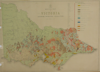 Federation University Historical Collection
Map, Department of Mines - Victoria, Geological Map of Victoria, 1936, 1936
... victoria...geology...Printed colour geological map of Victoria....Barker Library (top floor) Mount Helen goldfields victoria geology map geological map Printed colour geological map of Victoria. ...Printed colour geological map of Victoria.victoria, geology, map, geological map -
Whitehorse Historical Society Inc.
Document, Intrusive rocks of Melbourne, 1976
... Copy of page 373 from 'Geology of Victoria' on intrusive rocks of Melbourne by K.G. ...Copy of page 373 from 'Geology of Victoria' on intrusive rocks of Melbourne by K.G. ...Copy of page 373 from 'Geology of Victoria' on intrusive rocks of Melbourne by K.G. Bowen.Copy of page 373 from 'Geology of Victoria' on intrusive rocks of Melbourne by K.G. Bowen. At Tally Ho there is a circular plug, considered to be quartz diorite.Copy of page 373 from 'Geology of Victoria' on intrusive rocks of Melbourne by K.G. Bowen.mines and mining, geological society of australia -
 Stawell Historical Society Inc
Book, Norman Taylor, Geological Survey of Victoria No3, Geological Survey of Stawell, 1875-1876
... Geological Survey of Victoria No.3 Geological Survey of Stawell Norman Taylor 1875/76...Stawell Historical Society Inc 46 Longfield St Stawell grampians Geological Survey of Stawell 1875/76 by Norman Taylor, Geological Surveyor stawell mining Geological Survey of Victoria No.3 Geological Survey of Stawell Norman Taylor 1875/76 Yellow Card Front and Rear Cover with B/W Picture of mining scene. with black Plastic spine Geological Survey of Victoria No3, Geological Survey of Stawell Book Norman Taylor ...Geological Survey of Stawell 1875/76 by Norman Taylor, Geological SurveyorYellow Card Front and Rear Cover with B/W Picture of mining scene. with black Plastic spineGeological Survey of Victoria No.3 Geological Survey of Stawell Norman Taylor 1875/76stawell mining -
 Federation University Historical Collection
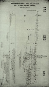
Plan, Underground Survey of Mines, Ballarat East. The Victoria United Company, 1903
... Underground Survey of The Victoria United Company from Geological Survey of Victoria, Memoirs No. 4....Barker Library (top floor) Mount Helen goldfields ballarat east, victoria united company cgt mining geological survey longitudinal section Underground Survey of The Victoria United Company from Geological Survey of Victoria, Memoirs No. 4. ...Underground Survey of The Victoria United Company from Geological Survey of Victoria, Memoirs No. 4.ballarat east, victoria united company, cgt, mining, geological survey, longitudinal section -
 Federation University Historical Collection
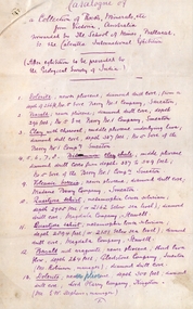
Document, SMB: Catalogue of a Collection of Rocks, Minerals, etc, 1883
... ...geology survey of india...victoria...This list of rocks, minerals, etc. from Victoria was complied and forwarded by the School of Mines, Ballarat, to the Calcutta International Exhibition. At the end of the exhibition the items were to be presented to the Geological Survey of India. ...He was also the Curator of the Ballarat School of Mines Museum. ballarat school of mines rocks minerals calcutta international exhibition geology survey of india victoria professor ferdinand moritz krause mineralogy geology curator ballarat school of mines museum Signature of F M Krause Dated 30th August 1883 6 pages, handwritten SMB: Catalogue of a Collection of Rocks, Minerals, etc. ...This list of rocks, minerals, etc. from Victoria was complied and forwarded by the School of Mines, Ballarat, to the Calcutta International Exhibition. At the end of the exhibition the items were to be presented to the Geological Survey of India. One Hundred items are listed. Pages 4 and 5 also show diagrams relating to the land formations and sections. Places in Victoria are named indicating where items were found. List compiled by Professor Ferdinand Moritz Krause. He joined Ballarat School of Mines in 1880 and lectured in Mineralogy and Geology. He was also the Curator of the Ballarat School of Mines Museum.6 pages, handwrittenSignature of F M Krause Dated 30th August 1883ballarat school of mines, rocks, minerals, calcutta international exhibition, geology survey of india, victoria, professor ferdinand moritz krause, mineralogy, geology, curator, ballarat school of mines museum -
Tarnagulla History Archive
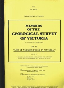
Photocopy of booklet: List of Nuggets Found in Victoria, List of Nuggets Found in Victoria, 1912 (original)
... Photocopy of the publication 'List of Nuggets Found in Victoria ' being No. 12 in the Memoirs of the Geological Society of Victoria....Tarnagulla History Archive Tarnagulla Public Hall 69-71 Commercial Rd Tarnagulla goldfields Murray Comrie Collection. tarnagulla nuggets gold mining prospecting Photocopy of the publication 'List of Nuggets Found in Victoria ' being No. 12 in the Memoirs of the Geological Society of Victoria. ...Murray Comrie Collection. Photocopy of the publication 'List of Nuggets Found in Victoria ' being No. 12 in the Memoirs of the Geological Society of Victoria.tarnagulla, nuggets, gold, mining, prospecting -
 Federation University Historical Collection
Book, Report on the Ballarat East Gold-Field, 1894 and Ballarat East Gold-Field, 1907, 1894
... geology...mining...ballarat east...llanberris...victoria...Gregory Professor of Geology at Glasgow University, Late Director of the geological Survey of Victoria and Professor of Geology at Melbourne University. ...The 1907 Report is number 4 in the Memoirs of the Geological Survey of Victoria. Photographs include Looking South from the Britannia Mullock Heap, View from Sovereign Hill, Golden Point gold discovery site....Gregory Professor of Geology at Glasgow University, Late Director of the geological Survey of Victoria and Professor of Geology at Melbourne University. ...The Ballarat Ironworkers' and Polytechnic Association was at the Ballarat School of Mines. In 1907 J.W. Gregory Professor of Geology at Glasgow University, Late Director of the geological Survey of Victoria and Professor of Geology at Melbourne University. W. Dickson was Secretary for Mines and Donald McLeod was the Minister of Mines. in 1894 Ernest Lidgey was the Assistant Geological Surveyor for the Victorian Department of Mines. A.W. Howitt was Secretary for Mines and Henry Foster was the Minister of Mines. Charcoal hard covered report on the Ballarat East Goldfield. The book combines two reports from the Victorian Department of Mines. The 1894 report is 52 pages and includes images and plans. The 1907 Report is number 4 in the Memoirs of the Geological Survey of Victoria. Photographs include Looking South from the Britannia Mullock Heap, View from Sovereign Hill, Golden Point gold discovery site.Stamped "Ballarat Ironworkers' Association School of Mines" Bookplate of the Ballarat Ironworkers' and Polytechnic Association. Written inside front cover: "S.J. Miller, 115 Ascot Street, Ballarat"ballarat ironworkers' and polytechnic association, ballarat school of mines, ironworkers, geology, mining, ballarat east, llanberris, victoria united mine, normanby, north woah hawp, bookplate, s.j. miller, library plate, golden point, gold discovery at golden point, new normanby mine, william baragwanath, new speedwell, britannia united, llanberris co, sulieman pasha, prince regent, dalzell-cum-prince regent, north prince extended, eastern star, f. gray, victoria united gold mine, sovereign hill mine, prince regent mine, britannia mine -
 Bendigo Historical Society Inc.
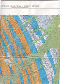
Map - STRUGNELL COLLECTION: GEOLOGICAL SURVEY OF VICTORIA, BENDIGO GOLD FIELD - GOLDEN SQUARE, 1992
... Map, Geological Survey of Victoria, Bendigo Gold Field - Golden Square, Campaspe 10 000/2.2. ...Victoria 10,000. Map STRUGNELL COLLECTION: GEOLOGICAL SURVEY OF VICTORIA, BENDIGO GOLD FIELD - GOLDEN SQUARE. ...Map, Geological Survey of Victoria, Bendigo Gold Field - Golden Square, Campaspe 10 000/2.2. Victoria 10,000.Dept. 0f Manufacturinf & Industry Development.map, bendigo, golden square gold field -
 Bendigo Historical Society Inc.
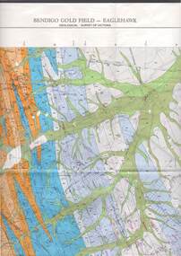
Map - STRUGNELL COLLECTION: GEOLOGICAL SURVEY OF VICTORIA, BENDIGO GOLD FIELD - EAGLEHAWK, 1992
... Map, Geological Survey of Victoria, Bendigo Gold Field - Eaglehawk.Campaspe10 000/2.3; Victoria 1:10,000. ...Map STRUGNELL COLLECTION: GEOLOGICAL SURVEY OF VICTORIA, BENDIGO GOLD FIELD - EAGLEHAWK ...Map, Geological Survey of Victoria, Bendigo Gold Field - Eaglehawk.Campaspe10 000/2.3; Victoria 1:10,000. Index of Shafts.Dept. of Manufacturing & Industry Developmentmap, bendigo, eaglehawk gold field -
 Bendigo Historical Society Inc.
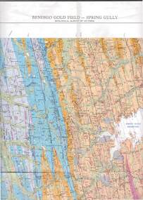
Map - STRUGNELL COLLECTION: GEOLOGICAL SURVEY OF VICTORIA, BENDIGO GOLD FIELD - SPRING GULLY, 1987
... Map, Geological Survey of Victoria, Bendigo Gold Field - Spring Gully, Campaspe 10 000 2/1; Victoria 10,000....Map STRUGNELL COLLECTION: GEOLOGICAL SURVEY OF VICTORIA, BENDIGO GOLD FIELD - SPRING GULLY. ...Map, Geological Survey of Victoria, Bendigo Gold Field - Spring Gully, Campaspe 10 000 2/1; Victoria 10,000.Cept. Of Industry, Technology & Resources.map, bendigo, spring gully gold field -
 Bendigo Historical Society Inc.
Book - MEMOIRS OF THE GEOLOGICAL SURVEY OF VICTORIA NO.12. LIST OF NUGGETS FOUND IN VICTORIA
... Memoirs Of The Geological Survey Of Victoria No.12. List Of Nuggets Found In Victoria. ...Victoria. Issued by Department of Mines, 69 pages in yellow soft cover. Book MEMOIRS OF THE GEOLOGICAL SURVEY OF VICTORIA NO.12. ...Memoirs Of The Geological Survey Of Victoria No.12. List Of Nuggets Found In Victoria. Issued by Department of Mines, 69 pages in yellow soft cover.Department of Minesvictoria, history, mining