Showing 3 items matching "geoscience australia"
-
 Bendigo Military Museum
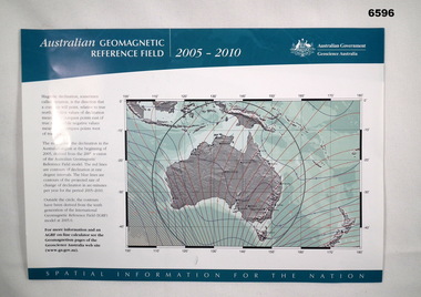
Flyer - Australian Geomagnetic Reference Field 2005-2010, Geoscience Australia, 2005
... ...Geoscience Australia...Geoscience Australia...Royal Australian Survey Corps RASvy Fortuna Army Survey Regiment Army Svy Regt Geoscience Australia Single A4 size sheet printed in colour on both sides Australian Geomagnetic Reference Field 2005-2010 Flyer Australian Geomagnetic Reference Field 2005-2010 Geoscience Australia ...Front side shows a map of australia with red lines of Magnetic Declination and blue lines depicting contours of the projected rate of declination change 2005 - 2010. The reverse side shows a world map with lines of magnetic declination at five-degree intervals. There are also three smaller Australian maps showing contours of "Total Field", "Horizontal Field (H)" and "Vertical Field (V)." Magnetic information was used extensively on the majority of maps produced by the Royal Australian Survey Corps, both topographic and aeronautical.Single A4 size sheet printed in colour on both sidesroyal australian survey corps, rasvy, fortuna, army survey regiment, army svy regt, geoscience australia -
 Bendigo Historical Society Inc.
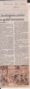
Newspaper - Kangaroo Flat Gold Mine Collection:, Department of Conservation and Environment, May 25/26 2002
... The project will involve 12 earth science agencies including the Victorian Department of Natural Resources and Environment, Geoscience Australia, the Cooperative Research Centre for Landscape, Environments and Mineral Exploration and the CSIRO. ...The project will involve 12 earth science agencies including the Victorian Department of Natural Resources and Environment, Geoscience Australia, the Cooperative Research Centre for Landscape, Environments and Mineral Exploration and the CSIRO. ...Victoria will be sliced in half during the next two years by earth scientists who expect to reveal hidden mineral wealth and better understand land degradation caused by salinity. By using instruments that send vibrations into the earth, geologists will peel back the surface layers to expose a hidden landscape of buried hills, valleys and fossil streams, undiscovered gold and mineral wealth, and giant extinct volcanos. The $3 million project, called the Victorian Geotraverse, will attempt to expose the processes that shaped the state and helped form its mineral wealth. The project will be discussed at a conference, Victoria Undercover, in Benalla this week. Project leader Neil Phillips, chief of CSIRO Exploration and Mining, said the project would attempt to discover where the rest of Victoria's gold deposits might be found and where the next salinity disaster might strike. Using this process they will cut a 500-kilometre swathe through the Grampians, Bendigo, Benalla and Wodonga, curving down to Mallacoota on the far east coast. The project will involve 12 earth science agencies including the Victorian Department of Natural Resources and Environment, Geoscience Australia, the Cooperative Research Centre for Landscape, Environments and Mineral Exploration and the CSIRO. ('Age' newspaper, 28th April, 2002. https://www.theage.com.au/national/going-to-ground-for-state-secrets-20020428-gdu5tz.html Scientists will send shocks through the Victorian earth which will be reflected back and recorded on instruments that will reveal the density of the rocks below.'Australian' newspaper article, 25/26th May, 2002, 'Geologists point to gold bonanza'. Article describes the $5 million Geotraverse research in Victoria, undertaken by CSIRO geologists, that 'estimate the northern plains of Victoria conceal up to 5000 tonnes of gold'. Image on bottom of article, possibly S.T. Gill watercolour, titled 'Victorian miners pan for gold in the mid-1800's'.bendigo mining n.l., bendigo, mining, gold, csiro, geologist, geology, victorian geotraverse project -
 Federation University Historical Collection
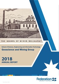
Booklet, Federation University Geoscience and Mining Group Annual Report, 2018, 2018
... australia...school of science and information technology...geoscience...Barker Library (top floor) Mount Helen goldfields federation university australia school of science and information technology geoscience and mining group stephen carey selwyn medal stafford mcknight ausimm manoj khandelwal michael tuck greg you larissa loroznikova ander guinea haydn swan ausimm central victoria regional symposium\rex berthelsen timor-leste study tour nicole cox alfredo piros scholarship fred canavan award national australian mining games ausimm cody holman keith whitehouse aden cross brendan carlisle daiel matthews fosterville central debosrah gold mining site visit weekeroo ballarat east mine, castlemaine goldfields, ballarat rerilya limited, broken hill catalyst metals, bendigo agr geoscience, ballarat evolution mninig, cowal ramuelius resources, mt magnet gold mine, wa downer mining Blue and white soft covered report. ...Blue and white soft covered report. A pdf of this report is available with this record. federation university australia, school of science and information technology, geoscience and mining group, stephen carey, selwyn medal, stafford mcknight, ausimm, manoj khandelwal, michael tuck, greg you, larissa loroznikova, ander guinea, haydn swan, ausimm central victoria regional symposium\rex berthelsen, timor-leste study tour, nicole cox, alfredo piros scholarship, fred canavan award, national australian mining games ausimm, cody holman, keith whitehouse, aden cross, brendan carlisle, daiel matthews, fosterville, central debosrah gold mining site visit, weekeroo, ballarat east mine, castlemaine goldfields, ballarat, rerilya limited, broken hill, catalyst metals, bendigo, agr geoscience, ballarat, evolution mninig, cowal, ramuelius resources, mt magnet gold mine, wa, downer mining