Showing 84 items matching gippsland floods
-
 Orbost & District Historical Society
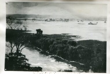
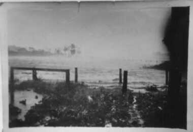
Photograph - Flood, Snowy River, Orbost 1978
... gippsland Flood, Snowy River, Orbost 1978 Photograph A b/w ...The Snowy River can flood over its floodplain at Orbost/Newmerella. There have been wet periods when floods were frequent and covered the floodplain, sometimes causing great disruption to crops and farming, and also to transport. The 1970s was a wet decade with many floods, the largest one in 1971. This photograph was taken in 1978. Evidence of flood on the Snowy River in 1978. A b/w photograph of a flood scene with trees and the river in the front, a river bank, and a vast area of water in the background. This photograph has been pasted onto a rough cardboard backing. Written below the photograph: Orbost 1978floods, snowy river, orbost -
 Orbost & District Historical Society
ginger jar, Pre 1893 floods in Orbost
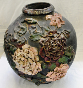
In the early days of Orbost many Chinese were engaged in land clearing or had arrived when gold was discovered in East Gippsland in the 1840's. They lived in camps along the Marlo Road and houses were usually built on stilts. They left after the 1893 floods.This object has aesthetic appeal. It is an object which belonged to the very early settlement days of Orbost.Huge, ornate Chinese ginger jar. Four raised hand- painted pink roses on front. Jar itself is matt black. Looks more like a vase than a ginger jar. Ceramic.Some Chinese writing to left hand side of roses.ceramics, ginger jar, container - domestic, vase -
 Federation University Art Collection
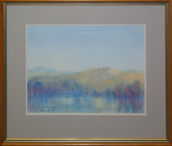
Watercolour on paper, 'Murray River Flood Plain', by David Alexander, 2004
Framed watercolour landscape depicting water in the foreground and mountains in the mid-ground.Signed and dated in ink lower left "DA Alexander '04"art, artist, david alexander, murray river, gippsland campus, landscape, watercolour, churchill -
 Koorie Heritage Trust
Book, Barraclough, Linda et al, A valley of glens : the people and places of the Upper Macalister River, 1988
Contents: Exploration & the Heyfield run; Glenmaggie, Glenfalloch & Glencairn; Gold & the first farms; The town begins; The farms are established; Selection to the limits; Fire, flood, drought, rabbits & other forms of pestilence; The second exploration; The weir is built; A time of change; Today & tomorrow.ix, 177 p. : ill. ; index; footnotes; sources; 25 cm.Contents: Exploration & the Heyfield run; Glenmaggie, Glenfalloch & Glencairn; Gold & the first farms; The town begins; The farms are established; Selection to the limits; Fire, flood, drought, rabbits & other forms of pestilence; The second exploration; The weir is built; A time of change; Today & tomorrow.upper macalister river -- east gippsland-history -
 Gippsland Art Gallery
Painting, Piggott, Owen, Flooding Light, 2008
... Painting Flooding Light Oil on canvas Gippsland artwork permanent ...Donated from the estate of the artist, 2016Oil on canvasgippsland, artwork, permanent collection -
 Inverloch Historical Society
Photograph, 1934 Dec - Pound Creek - tidal floods - pig paddock - side of house - Henderson property
-
 Inverloch Historical Society
000250 - Photograph - 1934 Dec - Pound Creek - tidal floods - pig paddock - Henderson property - E Henderson
-
 Inverloch Historical Society
000251 - Photograph - 1934 - Pound Creek - Henderson property - floods in front of house - E Henderson
-
 Inverloch Historical Society
000253 - Photograph - 1934 - Pound Creek - Henderson property - floods - water coming around pig paddock side of house - E Henderson
-
 Inverloch Historical Society
000241 - Photograph - 1934 - Pound Creek - Henderson property - front fence floods - E Henderson
-
 Inverloch Historical Society
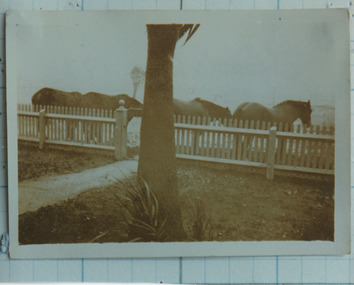
000236 - Photograph - 1934 Dec - Pound Creek - Henderson property - floods at front gate and horses - E Henderson
-
 Inverloch Historical Society
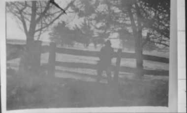
000171 - Photograph - 1934 Dec - Pound Creek - Tidal floods - Nick near stables and Henderson property fence - E Henderson
-
![Junction of the Rivers Yarra and Watt, Near Healesville / [by] Nicholas Caire, circa 1876](https://victoriancollections.net.au/media/collectors/550653872162f11fb04854aa/items/577740e5d0cdd10a5c0de011/item-media/57774153d0cdd10a5c0e0662/item-fit-380x285.jpg) Kew Historical Society Inc
Kew Historical Society IncPhotograph, Anglo-Australasian Photographic Company, Junction of the Rivers Yarra and Watt, Near Healesville, c. 1876
Nicholas Caire was born on Guernsey in the Channel Islands in 1837. He arrived in Adelaide with his parents in about 1860. In 1867, following photographic journeys in Gippsland, he opened a studio in Adelaide. From 1870 to 1876 he lived and worked in Talbot in Central Victoria. In 1876 he purchased T. F. Chuck's studios in the Royal Arcade Melbourne. In 1885, following the introduction of dry plate photography, he began a series of landscape series, which were commercially successful. As a photographer, he travelled extensively through Victoria, photographing places few of his contemporaries had previously seen. He died in 1918. Reference: Jack Cato, 'Caire, Nicholas John (1837–1918)', Australian Dictionary of Biography.An original, rare photograph from the series 'Views of Victoria: General Series' by the photographer, Nicholas Caire (1837-1918). The series of 60 photographs that comprise the series was issued c. 1876 and reinforced a neo-Romantic view of the Australian landscape to which a growing nationalist movement would respond. Nicholas Caire was active as a photographer in Australia from 1858 until his death in 1918. His vision of the Australian bush and pioneer life had a counterpart in the works of Henry Lawson and other nationalist poets, authors and painters.Albumen Silver Photograph, mounted on Board.printed in ink on support l.c.: JUNCTION OF THE RIVERS YARRA AND WATT, NEAR HEALESVILLE. / COPYRIGHT REGISTERED. printed in ink on support reverse c.: VIEWS OF VICTORIA. / (GENERAL SERIES.) / No. 3. / JUNCTION OF THE RIVERS YARRA AND WATT, NEAR HEALESVILLE / The junction is situated about 3 miles from Healesville, and 35 miles from the mouth of the Yarra. The souces / of the Watt are to be found at the head of the Black Spur, and, being fed by a number of creeks and springs, its / waters gain considerable force for several miles before joining those of the Yarra. The "Old Bridge," at the junction, / is the name given to this crossing-place, which has been partly swept away by late floods. The depth of the Yarra here / is from 15 to 20 feet; that of the Watt, about 10 feet. printed in ink on support reverse l.c.l.: J.W. FORBES, Agent, printed in ink on support reverse l.c.: ANGLO-AUSTRALASIAN PHOTOGRAPHIC COMPANY, MELBOURNE. printed in ink on support reverse l.c.r.: 10 Temple Court, Collins Street West.nicholas caire (1837-1918), yarra river, watt river, bridge, wooden bridge, healesville -
![Scene on the River Campaspe / [by] Nicholas Caire, circa 1876](https://victoriancollections.net.au/media/collectors/550653872162f11fb04854aa/items/577b50b0d0cdd10948cb4cf6/item-media/577b51d2d0cdd10948cbedda/item-fit-380x285.jpg) Kew Historical Society Inc
Kew Historical Society IncPhotograph, Anglo-Australasian Photographic Company, Scene on the River Campaspe, c. 1876
Nicholas Caire was born on Guernsey in the Channel Islands in 1837. He arrived in Adelaide with his parents in about 1860. In 1867, following photographic journeys in Gippsland, he opened a studio in Adelaide. From 1870 to 1876 he lived and worked in Talbot in Central Victoria. In 1876 he purchased T. F. Chuck's studios in the Royal Arcade Melbourne. In 1885, following the introduction of dry plate photography, he began a series of landscape series, which were commercially successful. As a photographer, he travelled extensively through Victoria, photographing places few of his contemporaries had previously seen. He died in 1918. Reference: Jack Cato, 'Caire, Nicholas John (1837–1918)', Australian Dictionary of Biography.An original, rare photograph from the series 'Views of Victoria: General Series' by the photographer, Nicholas Caire (1837-1918). The series of 60 photographs that comprise the series was issued c. 1876 and reinforced a neo-Romantic view of the Australian landscape to which a growing nationalist movement would respond. Nicholas Caire was active as a photographer in Australia from 1858 until his death in 1918. His vision of the Australian bush and pioneer life had a counterpart in the works of Henry Lawson and other nationalist poets, authors and painters.Views of Victoria (General Series) No.25 / ‘Scene on the River Campaspe’ / Albumen silver photograph mounted on boardOn Reverse: ‘The River Campaspe flows into the River Murray, near the Town of Echuca. It is a river of considerable size, and is subject to frequent overflowing of its banks, in consequence of the low flat country through which it runs. Our illustration represents the River during one of the periodical floods, its depth being over thirty feet at the time.’nicholas caire (1837-1918), australia - landscape photography -
![The Punt, Echuca / [by] Nicholas Caire, circa 1876](https://victoriancollections.net.au/media/collectors/550653872162f11fb04854aa/items/57825721d0cdd1176ce1789a/item-media/57825765d0cdd1176ce19829/item-fit-380x285.jpg) Kew Historical Society Inc
Kew Historical Society IncPhotograph, Anglo-Australasian Photographic Company, The Punt, Echuca, c. 1876
Nicholas Caire was born on Guernsey in the Channel Islands in 1837. He arrived in Adelaide with his parents in about 1860. In 1867, following photographic journeys in Gippsland, he opened a studio in Adelaide. From 1870 to 1876 he lived and worked in Talbot in Central Victoria. In 1876 he purchased T. F. Chuck's studios in the Royal Arcade Melbourne. In 1885, following the introduction of dry plate photography, he began a series of landscape series, which were commercially successful. As a photographer, he travelled extensively through Victoria, photographing places few of his contemporaries had previously seen. He died in 1918. Reference: Jack Cato, 'Caire, Nicholas John (1837–1918)', Australian Dictionary of Biography.An original, rare photograph from the series 'Views of Victoria: General Series' by the photographer, Nicholas Caire (1837-1918). The series of 60 photographs that comprise the series was issued c. 1876 and reinforced a neo-Romantic view of the Australian landscape to which a growing nationalist movement would respond. Nicholas Caire was active as a photographer in Australia from 1858 until his death in 1918. His vision of the Australian bush and pioneer life had a counterpart in the works of Henry Lawson and other nationalist poets, authors and painters.Views of Victoria (General Series) No.34; ‘The Punt, Echuca’; Albumen silver photograph | Photo on card with Title and Description on reverse | Mounted 24 x 30 cm; Photo 12 x 17 cm.On Reverse: ‘The subject of this illustration is the principal crossing-place on the River Murray at Echuca, as regards the ordinary road traffic from the district of Riverina, New South Wales. After the periodical floods, the Punt is found to be insufficient for the large traffic; but this inconvenience will not be found to occur again to any great extent, as the new Railway Bridge from Moama will considerably lessen the road traffic through the Township of Echuca.’nicholas caire (1837-1918), echuca (vic), landscape photography -
![View on the Upper Buckland River / [by] Nicholas Caire, circa 1876](https://victoriancollections.net.au/media/collectors/550653872162f11fb04854aa/items/57830fc0d0cdd1176c450fda/item-media/57831013d0cdd1176c454bda/item-fit-380x285.jpg) Kew Historical Society Inc
Kew Historical Society IncPhotograph, Anglo-Australasian Photographic Company, View on the Upper Buckland River, c. 1876
Nicholas Caire was born on Guernsey in the Channel Islands in 1837. He arrived in Adelaide with his parents in about 1860. In 1867, following photographic journeys in Gippsland, he opened a studio in Adelaide. From 1870 to 1876 he lived and worked in Talbot in Central Victoria. In 1876 he purchased T. F. Chuck's studios in the Royal Arcade Melbourne. In 1885, following the introduction of dry plate photography, he began a series of landscape series, which were commercially successful. As a photographer, he travelled extensively through Victoria, photographing places few of his contemporaries had previously seen. He died in 1918. Reference: Jack Cato, 'Caire, Nicholas John (1837–1918)', Australian Dictionary of Biography.An original, rare photograph from the series 'Views of Victoria: General Series' by the photographer, Nicholas Caire (1837-1918). The series of 60 photographs that comprise the series was issued c. 1876 and reinforced a neo-Romantic view of the Australian landscape to which a growing nationalist movement would respond. Nicholas Caire was active as a photographer in Australia from 1858 until his death in 1918. His vision of the Australian bush and pioneer life had a counterpart in the works of Henry Lawson and other nationalist poets, authors and painters.‘View on the upper Buckland River’ : Views of Victoria (General Series) No.46 : Albumen silver photograph | Photo on card with Title and Description on reverse | Mounted 24 x 30 cm; Photo 12 x 17 cm.On Reverse: ‘The Buckland River is situated near the western extremity of the Australian Alps, and forms one of the sources of the Ovens River. Its watercourse is very shallow, except in flood time. Our illustration is taken on the upper portion of the River, near Reeve’s dam.’nicholas caire (1837-1918), buckland river (vic), landscape photography - victoria -
 Orbost & District Historical Society
newspaper clippings, February 1971
These articles were compiled by Mary Gilbert who was the first curator of the Orbost Museum and a prominent historian / teacher in Orbost. The 1971 floods at Orbost were the worst on record. At Jarrahmond the river rose to a height of 11 metres and on the flats spread to one and a half kilometres wide. Considerable damage was done to railway infrastructure, roads and farms. More information from the APRIL, 2008 newsletter by John Phillips. (see orbosthistory.com.au)These articles are contemporary records of a significant historical event in Orbost.A manila folder containing black / white newspaper clippings from various publishers. They all relate to the 1971 floods in Orbost. (Details of contents in catalogue 735-900)floods-orbost-1971 -
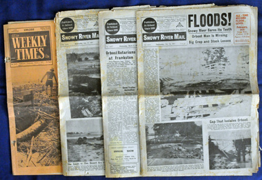
 Orbost & District Historical Society
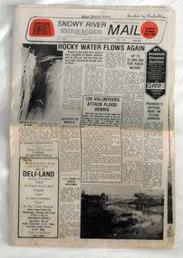
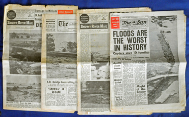
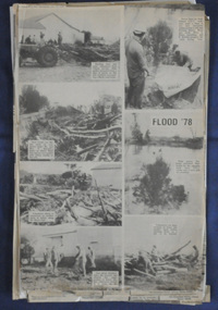
newspaper, Snowy River Mail, June 14 1978
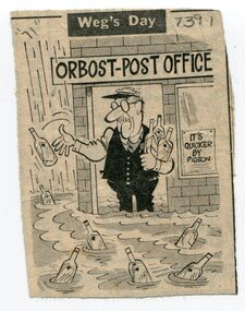
Orbost has been subject to major floods throughout its history, such as those which left the town isolated in 1934, 1952, 1971 and 1978. It is recorded that the Snowy River broke its banks and flooded the flats 104 times between 1884 and 1978. Extensive flooding in Eastern Victoria during June 1978, caused widespread damage to roads, road closures and hazards to traffic, particularly over the Queen's Birthday holiday weekend.Since 1890 the Snowy River Mail has been the local newspaper of the Orbost district.This local paper has been the means by which readers in Orbost were able to learn about newsworthy events and issues in their local community for over a century. This paper is a contemporary record of a significant event in Orbost's history of flooding.A newspaper, Snowy River Mail, which contains black / white photographs of the 1978 floods in Orbost.orbost-floods-1978 -
 Orbost & District Historical Society
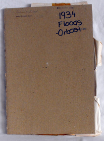
collection of newspaper articles, 1917, 1929, 1934
These articles were collated by Mary Gilbert. Mary Isabelle Gilbert was born in 1905 in Orbost, Australia. She was born to John Gilbert and Annie Cameron Gilbert. She was a teacher historian loved and respected by her family and the wider community.These articles are contemporary records of significant events in the history of Orbost and as such are useful reference tools.A cardboard folder of black and white newspaper cuttings relating to the 1934 floods in Orbost, war photographs and local events and residents. 747.1 is from the February 3, 1934 Weekly Times and is titled, " FLOOD PHOTOS ORBOST". 747.2 is from the Weekly Times, 9 June 1917 and contains war photos and photographs of Orbost - 11 May, 1929.orbost-floods-1934 ww1-photgraphs-orbost-weekly-times -
 Orbost & District Historical Society
display cabinet and tools
This display was put together by the Curlip Committee and used as promotion in the shed during the construction of Curlip 11 A community project, this boat was constructed out of local hardwood timbers utilizing the traditional skills of wooden boat builders and is powered by a steam engine. Paddle Steamer Curlip II is a replica of an historic paddle steamer of the Snowy River, in Far East Gippsland, Victoria. The original Paddle Steamer Curlip was built by Sam Richardson and his sons Mark, Albert and Frank, at their sawmill at Tabbara, a pioneering settlement on the Brodribb River, a tributary of the Snowy River. The keel was laid on 14th October 1889 and PS Curlip was launched in 1890. The name “ Curlip” is derived from the indigenous name for the area where Tabbara is located and includes land to the east of the Snowy and Brodribb Rivers towards Cape Conran. PS Curlip was registered in 1893 and the Passenger Certificate issued on 30th January 1903 to Captain Alan Richardson by the Marine Board of Victoria entitled her to carry 25 passengers and only 10 passengers when engaged in towage service. Two children under 12 years of age to be reckoned as one passenger. PS Curlip towed five barges at a time, traveling upstream as far as Bete Bolong, 20 km upstream of the mouth to collect produce to be transferred to schooners near Marlo. She towed vessels in and out through the Snowy river entrance and was also used for social functions such as Sunday School picnics. She was the main means of transport for imports and exports on the Snowy River for almost 30 years. The Curlip era ended abruptly on Friday 28th February when a flash flood carried her and 2 barges down river and out to sea, where she washed ashore at Marlo and broke up.More than eighty years after the original Paddle Steamer Curlip was wrecked at sea, the Orbost community launched a replica which it hoped would draw tourists to the region. The P.S. Curlip II, is based on drawings of the original Curlip that made its home in the Snowy and Brodribb Rivers of East Gippsland in the 1890s and early 1900s, It took six years of planning and hundreds of hours of volunteer work from the local community.A display cabinet containing tools and sundry items related to the Paddle Steamer Curlip. (More information on individual items in Catalogue 1400-1600)p.s.curlip richardson-samuel boat-building-tools transport -
 Orbost & District Historical Society
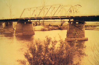
photograph, first half of 20th century prior to 1976
Purchased from Orbost Op shop several years ago. Original owner unknown. This bridge over the Snowy River was opened on July 4 1922. It was constructed in 1922 alongside the previous suspension bridge. Its building was a combined effort of the Victorian Railways and the Country Roads Board at a cost of 35,000 pounds. It was replaced in 1976 by the present bridge after several major floods.This bridge was replaced in 1976 after several major floods.A wooden framed photograph of the second Snowy River bridge at Orbost.photograph snowy-river-bridge -
 Orbost & District Historical Society
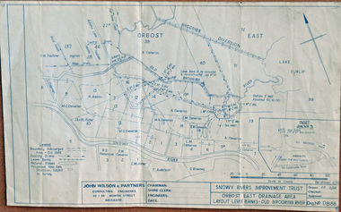
plan, December 1968
Brodribb floodplain regularly inundated in the late 1800s and early 1900s. Works included: clearing the river channel and blocking ‘gulches’. The meander was cut-off in 1931, as part of the Orbost East Drainage Scheme and further developed after 1934 floods and again in the early 1950s when levee banks and a regulator were constructed. (ref. East Gippsland Catchment Management)This is a useful reference tool.A hand-drawn plan of the layout of the levee banks of the Old Brodribb River.brodribb-river map plan-levee-banks -
 Orbost & District Historical Society
plan, before 1948
Drainage infrastructure was developed and maintained in this region by the Snowy River Improvement Trust. The Trust was administered by a local committee and its activities funded by a local rate charged on the farmers and land owners in the Trust’s designated district. The level of the rate charged by the Trust was designed to be proportionate to the benefit derived from the works undertaken. Financial assistance was provided by the State Government from time to time for specific projects such as post flood repairs but not for new capital works. The Trust undertook new drainage and river management works including tree planting, rock beach construction and servicing of the drains and flood gates. The Trust also provided a personal flood warning service to the farmers in its district. The Trust ceased to operate in 1997 with the advent of the East Gippsland Catchment Management Authority. The infrastructure developed by the Trust continues to provide a service to the farmers in the region. (ref. 4 East Gippsland CMA Submission to Inquiry into Flood Mitigation Infrastructure in Victoria) This plan is significant as a historical document. The Snowy River Improvement Trust was vital to the Orbost district because of its ability to apply local knowledge and to engage the local farming community.A large plan of divisions of land for the purpose of levying the Snowy River Improvement District - Bete Bolong, Orbost, Waygara, Newmerella and Orbost East. The properties are coloured according to levy amount. The scale is 1" - 20 chains. snowy-river-improvement-trust -
 Orbost & District Historical Society
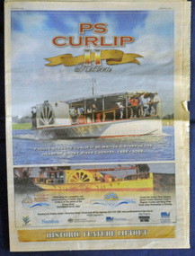
newspaper, PS Curlip, November 2008
This inset was published to commemorate the Curlip Festival on 28/30 November 2008 and the P.S. Curlip 11 launch. The Snowy River Mail is an East Gippsland Newspaper. The original PS Curlip was a paddle steamer built in a Tabbara sawmill in 1889 by Samuel Richardson and his sons. It was operated along the Snowy River in Australia's Gippsland region between 1890 and 1919, before being washed out to sea, and broken on Marlo beach, by a flash flood. The Orbost and district community started a project in 2002 to construct a live steam powered replica, albeit somewhat larger than the original to meet safety regulations and carry additional passengers for commercial reasons, the Paddle Steamer Curlip II with the assistance of grants from the Federal and Victorian State Governments.Construction was started in earnest by shipwright, Bill Jones, in August 2006, and with the assistance of roughly 200 volunteers (a core group of 10 performing the majority of the work), she was finally completed and launched on the Snowy River in late November 2008. The construction of P.S.Curlip 11 was a community project which began as a project to re-engage the timber-working community of Orbost. The construction and launch was a major community event. The local newspaper, The Snowy River Mail, documented its progress on a regular basis.An insert from the Snowy River Mail newspaper dated November 2008. On the front cover is a coloured photograph of the Paddle Steamer Curlip 11. It contains photographs, information on the history of P.S. Curlip and the construction of Curlip 11. There are details of the Curlip Festival and advertisements.newspaper p.s.curlip -
 Orbost & District Historical Society
newspapers, February, March 1971
The 1971 flood was the the worst flood on record. At Jarrahmond it was at least 11 metres and up to one and a half kilometres wide on the flats causing enormous damage to the flood plain. Records say that "The brown floodwater stain in Bass Strait could be seen from passing airliners." Considerable damage was done to railway infrastructure, roads and farms. More information from the APRIL, 2008 newsletter by John Phillips. (see orbosthistory.com.au) These newspapers are contemporary records of a significant local event.Four newspapers relating to the floods in 1971. They contain news articles and photographs of the floods in Orbost in early 1971. 2556.1 is the Weekly Times dated 3.3.1971 and has an orange cover. 2556.2 is a Snowy River Mail dated 17.2.1971. 2556.3 is a Snowy River Mail dated 10.2.1971. 2556.4 is a Snowy River Mail dated 3.3.1971.floods-orbost-1971 snowy-river-mail weekly-times newspapers -
 Orbost & District Historical Society
newspapers, February 1971
The 1971 floods at Orbost were the worst on record. At Jarrahmond the river rose to a height of 11 metres and on the flats spread to one and a half kilometres wide. Considerable damage was done to railway infrastructure, roads and farms. More information from the APRIL, 2008 newsletter by John Phillips. (see orbosthistory.com.au)These newspapers are contemporary records of a significant local event.Four newspapers and a set of clippings from various papers. They contain information and photographs pertaining to the 1971 floods in Orbost. 2557.1 is a Sun News Pictorial dated 8.2.1971. 2557.2 is a Snowy River Mail dated 10.2.1971. 2557.3 is an east Gippsland News dated 12.2.1971. 2557.4 is a Snowy River mail dated 12.2.1971 and 2557.5 is a collection of various clippings.floods-orbost-1971 newspaper snowy-river-mail sun-news-pictorial -
 Orbost & District Historical Society
newspaper clippings, June 1978
Orbost has been subject to major floods throughout its history, such as those which left the town isolated in 1934, 1952, 1971 and 1978. It is recorded that the Snowy River broke its banks and flooded the flats 104 times between 1884 and 1978. Extensive flooding in Eastern Victoria during June 1978, caused widespread damage to roads, road closures and hazards to traffic, particularly over the Queen's Birthday holiday weekend. These newspaper articles are contemporary records of a significant event in Orbost history.A collection of black/white newspaper clippings relating to the 1978 flood in Orbost. Some are original articles. others are photo-copies. They appear to be from the Snowy River Mail newspaper.floods-orbost-1978 newspaper-articles -
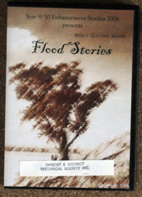 Orbost & District Historical Society
D.V.D, Flood Stories, 2006
... gippsland D.V.D. Flood Stories A D.V.D. in a black plastic case ...In October 2006, Orbost Secondary College 9/10 Enhancement Studies Class worked to preserve the memories of the Orbost community with three short films describing recollections of Orbost floods. There are ten stories including memories of the 1952, 1971 and 1991 floods. They are narrated by various Orbost identities - Anne Bridges; Kay Lynn; Ken Edlington; Margaret Adams; Max Reynols; Shirley Reynolds and Ngaere Donald.Floods have been part of the history of Orbost since settlement. These stories record impressions of local people.A D.V.D. in a black plastic case. On the cover ia a brown sketch of a tree. Above in black print is the title, "Flood Stories" with " Year 9/10 Enhancement Studies 2006 presents" at the top.sticker and stamp - Orbost & District Historical Society -
 Orbost & District Historical Society
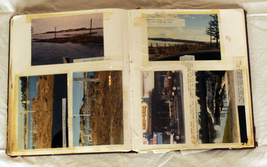
album, Our Natural Disasters Hailstorm 1991 Floods 1934-1998, between 1998 and 2003?
This album was compiled for the use of visitors to the Slab Hut (Orbost Visitor Information Centre).This album is a useful research tool.A photo album with a maroon cover with gold embossing. On the cover is the title Our Natural Disasters. It contains 54 pages of photos of local natural disasters - flood, fire and hail. The photos are taped in.slab-hut orbost-disasters album orbost-floods-fires-hailstorms -
 Orbost & District Historical Society
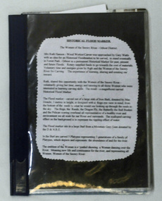
folder, Historical Flood Marker, 1999 - 2001
... gippsland folder Historical Flood Marker A loose leaf folder ...This folder contains a record of the construction of the flood marker in Forest Park, Orbost. It depicts the six highest floods since the first recording. The construction of the marker was commenced in August 1999 and took eighteen months to be completed by nine volunteers under the tutelage of Ruth Hansen.This item is a contemporary record of the construction of an iconic marker in Orbost.A loose leaf folder containing information, records and photographs about the Historic Flood Marker in Forest Park, Orbost. Most photographs and printed text are glued in. There are twelve loose photographs.The front cover and spine are dark blue, the back is a lighter blue and has a bar code and price sticker attached.flood-marker-orbost