Showing 461 items matching gold fields
-
 Chiltern Athenaeum Trust
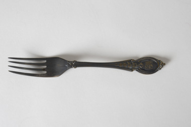
Domestic object - Fork
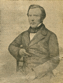
... gold fields... history research regarding life on the Gold Fields in the 1850s... and the surrounding region. w.c. busse chiltern chiltern athenaeum gold fields ...This fork is believed to belong to the household of Chiltern writer and historian, W.C. Busse. It displays a level of tarnish indicating it may be comprised of silver or silver plate. It has no evident hallmark to determine its maker or date of manufacture, but may pre-date World War Two as mass production methods and the growing popularity of stainless steel in cutlery and other tablewares saw a reduced reliance on silver in such goods after this period. The handle of the fork appears to display the initials 'WB', potentially indicating it was made to order. Wilfred Clarence Busse was born in Chiltern in 1898. He went to school at Wesley College in Melbourne, studied law at the University of Melbourne and became a barrister. Additionally, after spending time on a Victorian station in his early twenties, he wrote two historical novels about bush life. His first novel was 'The Blue Beyond: a Romance of the Early Days in South Eastern Australia', written in 1928 and published in 1930. Busse's second novel was titled 'The Golden Plague: A Romance of the Early Fifties'. The judges of the Henry Lawson Society's T.E. Rofe competition to advance Australian literature unanimously awarded it the Gold Medal in 1931 for the best historical novel of 1930. Newspaper articles about the award mention the writer's meticulous documentary and oral history research regarding life on the Gold Fields in the 1850s. It became a best-seller. Busse also wrote a series of articles about local history for "The Federal Standard" newspaper in Chiltern. He was a member of the Chiltern Athenaeum. He died in 1960.This fork is significant for the detail it conveys of ordinary domestic life in the household of a significant Victorian writer with special reference to Chiltern and the surrounding region.Fork with decorative pattern on handle and tarnished patina, design may include owner's or maker's initials. WB w.c. busse, chiltern, chiltern athenaeum, gold fields, indigo shire, gold mining, gold rush, henry lawson society, fork, silverware, cutlery, tableware, 1930s, 1850s, wilfred clarence busse, historical fiction, t.e. rofe, t.e. rofe gold medal, north-east victoria, federal standard, golden plague, blue beyond -
 The Beechworth Burke Museum
Photograph, Unknown
... gold fields... fields gold rush victorian gold rush mining tunnels gold ming ...The A1 Gold Mine is located north of Woods Point, near Jamieson, in the Upper Goulburn region of Victoria. Gold was discovered at the A1 site in 1861 and mining operations began in 1864. The A1 Mine Settlement refers to a small township known variously as Castle Reef, Castle Point, and Raspberry Creek, which developed in the 1860s around mining industry centred on a crushing machine that worked the three gold reefs in the area. Historically, the name "A1"referred to the high quality of gold found in the quartz reefs at depths of at least two thousand feet. Along with the Morning Star mine at Woods Point, the A1 gold mine produced almost sixty percent of Victoria's gold output in the 1950s to 1970s and continued operating until 1992 when it went into administration. Operations at the site were revived in 2016 and the A1 Mine is now considered one of Victoria's premier gold mines. The A1 mine is part of the extensive and prospective Lachlan Fold Belt, a north-west trending belt of tightly folded Early Devonian sedimentary rocks extending from New South Wales to Victoria. Mineralisation is hosted within or immediately adjacent to diorite dykes. Contemporary development of the 'Queens Lode' at the A1 mine signals a move from high-grade, narrow vein airleg mining into larger scale, mechanical mining designed to increase ore production volume. This original, undated photograph of the A1 Mine appears to depict an area or phase of disuse or abandonment. The aged and humble appearance of the cottage suggests association with the historical A1 Mine Settlement, therefore the image may have been taken prior to the 1950s-1970s revival period in which the A1 mine is known to have produced high gold yields. The photograph contributes to our understanding of the A1 Gold Mine's impact on the landscape and the social, environmental impacts of mining on communities and may be compared with others in the Burke Museum's extensive collection of mining photographs to deepen our understanding of mining in the Jamieson area.Black and white rectangular photograph printed on photographic paperReverse: 5577 / A1 Mine / Near Jamieson / Vic. /burke museum, beechworth museum, beechworth, gold fields, gold rush, victorian gold rush, mining tunnels, gold ming history, colonial australia, australian gold rushes, mining technology, beechworth historic district, indigo gold trail, indigo shire, upper goulburn shire, jamieson, woods point-walhalla goldfield, a1 gold mine, victorian high country, modern mining methods, orogenic gold province, gold mineralisation, devonian, dykes -
 The Beechworth Burke Museum
Photograph - Photograph - Reproduction, ca. 1900
... gold fields... museum beechworth museum beechworth gold fields gold rush ...This image shows the approach to Beechworth from the south-west via the Newtown Bridge. Numerous early buildings line the road as it bifurcates to become Ford and High Streets on the ridge above Spring Creek and Newtown Falls. The sloping, rocky terrain and water course along the gorge show evidence of the intense mining activity that occurred at the site. The Ovens Gold Rush at Beechworth started when gold was found at Spring Creek in February 1852, prompting an influx of miners from around the world. The population grew over 20,000 by 1857. While the earliest mining at Beechworth was similar to that in other Victorian goldfields like Ballarat and Bendigo, Beechworth is notable for its use of hydraulic sluicing as a major method of removing wash-dirt. Hydraulic sluicing employs high pressure jets of water to blast away large areas of earth and wash it down to be run through a sluice box. Gold gets caught in the sluice and the remaining slurry is washed away. This method of mining is extremely effective but causes significant environmental impacts and damage to waterways. Large water quantities were required for large-scale sluicing, and the long water races and deep tailraces that were constructed in the Beechworth area in the nineteenth century are nonetheless considered feats of engineering. The site in the photograph is associated with the Rocky Mountain Mining Company who constructed an eight hundred meter tunnel under the township between 1876-1880 to reduce water levels at Spring Creek, which had been subject to diversions since the earliest days of alluvial mining. Over four million ounces of gold (115 tones) were found at Beechworth between 1852 and 1868, and the wealth from the gold rushes built Beechworth and the nationally significant buildings that remain standing today.This image shows the early development of the Beechworth township above Spring Creek, where gold was discovered in 1852. Evidence of hydraulic sluicing, a uniquely predominant method at Beechworth, and water-works engineering are present in the landscape. By the 1870s, alluvial gold deposits were depleted and increasingly complex engineering was required so deeper shafts could reach bedrock. This image is significant for understanding changes to the landscape and the evolution of mining methods and engineering practices related to the extensive construction, manipulation and management of water networks. The shift from smaller scale alluvial mining to larger company dominance in the mining industry has implications for understanding wider social, economic, political and industrial changes in the region of Beechworth and within the context of the Victorian Gold Rush more broadly. A black and white rectangular reproduction photograph printed on photographic paper. burke museum, beechworth museum, beechworth, gold fields, gold rush, victorian gold rush, hydraulic sluicing, rocky mountain mining company, spring creek, netwown falls, mining tunnels, water races, tailraces, colonial australia, australian gold rushes, mining technology, beechworth historic district, indigo gold trail, migration, indigo shire, gold mining, gold mining history -
 The Beechworth Burke Museum
Photograph, c1900
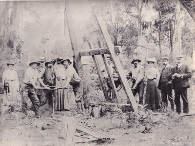
... gold fields... Gold gold fields Gold rush Miners ...A black and white photograph depicting seven men and four women surrounded by tunnel boring machinery. A tunnel boring machine (TBM), also known as a "mole", is a machine used to excavate tunnels with a circular cross section through a variety of soil and rock strata. They may also be used for microtunneling. They can be designed to bore through anything from hard rock to sand. Tunnel boring machines are used as an alternative to drilling and blasting (D&B) methods in rock and conventional "hand mining" in soil. TBMs have the advantages of limiting the disturbance to the surrounding ground and producing a smooth tunnel wall. This significantly reduces the cost of lining the tunnel, and makes them suitable to use in heavily urbanised areas. The major disadvantage is the upfront cost. TBMs are expensive to construct, and can be difficult to transport. The longer the tunnel, the less the relative cost of tunnel boring machines versus drill and blast methods. This is because tunneling with TBMs is much more efficient and results in shortened completion times, assuming they operate successfully. Drilling and blasting however remains the preferred method when working through heavily fractured and sheared rock layers.This photograph is significant as it shows the machinery used and attire worn by men and women during the gold rush era. Black and white rectangular photograph printed on photographic paperburke museum, mining, beechworth, boring machinery, excavate, gold, gold fields, gold rush, miners -
 The Beechworth Burke Museum
Photograph, 1920-1950
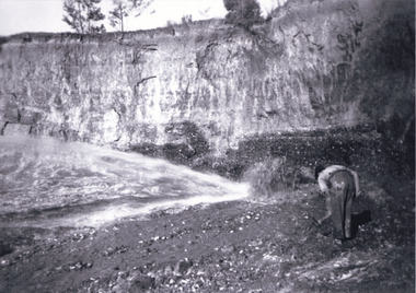
... gold fields... beechworth gold fields gold rush victorian gold rush hydraulic ...This image taken between 1920-1930 depicts open-cut hydraulic sluicing at the Three Mile Mine, located about five kilometres south of Beechworth. Alluvial, or surface, mining began on this site in the 1850s, but was soon replaced by hydraulic sluicing methods. By the start of 1880 it is estimated that nine hundred miles of water races had been cut though soil and rock in the Beechworth district. Hydraulic sluicing employs high pressure jets of water to blast away large areas of earth and wash it down to be run through a sluice box. Gold gets caught in the sluice and the remaining slurry is washed away. Large water quantities were required for hydraulic sluicing, and the long water races and deep tailraces that were constructed were considered great engineering feats. This method of mining is extremely effective, but causes significant environmental damage and impacts to waterways and agricultural operations. Miners at Beechworth built extensive networks of races and dams to secure reliable supplies of water on a scale far greater than elsewhere in Victoria. By the 1880s Beechworth's water barons continued to hold more than half of all the water right licences on issue and undertook sluicing operations on a massive scale. The manipulation of surface and ground water via race networks was well planned and recorded in detail by local mining surveyors. The maps that were created, combined with modern geo-spatial technologies, provide a vital key in understanding the great lengths to which miners went to capture and control critical water resources. Today, Three Mile mine is called Baarmutha. The Three Mile Mine was unproductive until 1865 when John Pund and three other miners secured a fifteen year license and constructed a water race from Upper Nine Mile Creek to Three Mile Creek. In the early twentieth century Pund & Co. averaged over one thousand ounces of gold per year from the mine. After Pund's death in 1915, GSG Amalgamated Co operated the site, continuing sluicing until 1950. This image of hydraulic sluicing methods shows the extent of water-works engineering in the landscape. This photograph has historic and research potential for understanding changes to the landscape, the evolution of mining methods, and the extensive construction, manipulation and management of water networks in the Beechworth district. Black and white rectangular photograph on matte paperReverse: 7597-1 / Sluice Mining / Copied from original on loan from Webb (Qld) / Donated Nov 2009 / Baarmutha Three Mile Mine c1920-1950 / Managed by the Plain Bros then Parkinsons / Current Location is: Beechworth Animal Shelter / used for Baarmuthaburke museum, beechworth museum, beechworth, gold fields, gold rush, victorian gold rush, hydraulic sluicing, spring creek, netwown falls, mining tunnels, water races, tailraces, gold ming history, colonial australia, australian gold rushes, mining technology, beechworth historic district, indigo gold trail, indigo shire, john pund, water manipulation, water engineering, three mile creek, three mile mine, water race, large-scale mining methods, historical mining construction, alluvial mining, mining environmental impacts, baarmutha, water barons -
 Federation University Historical Collection
Map, Creswick Gold Field Map, 1981
... Creswick Gold Field Map...gold fields...Map Map Creswick Gold Field Map Rectangular geological map ...A fragment of the original 1880 map is also held in the collection. See 116Rectangular geological map with brown paper strip on top edge with 4 holes on top edge. Scale is 40 chains to one inch.Geologically and topographically surveyed by Ferdinand M Krause. Lithographed by R. Shepherd. Printed by J. Finnie. Mining Department, Melbourne. Preprinted with additional shaft and lead detail. F. D. Atkinson, Government Printer 1981creswick, krause, surveyor, smeaton, spring hill, tourello, ascot, dean, bullarook, gold fields, gold -
 Marysville & District Historical Society
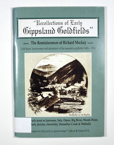
Book - Paperback book, Recollections of Early Gippsland Goldfields-The Reminiscences of Richard Mackay, 2000
... gold fields... gold gold fields gold miner gold mining gold town gippsland ...Recollections by Richard Mackay of the early history of the Gippsland goldfieldsPaperback. Cover is green. Front cover has a sepia photograph of a drawing with the caption 'Walhalla in its heyday. Back cover has a photograph of an old building with a sign on it that says 'Copper Mine Hotel'. There is a man standing in front of the building. In the foreground is a four wheel drive vehicle.Stamp of the Marysville & District Historical Society Inc / P.O. Box 22 / Marysville 3779gold, gold fields, gold miner, gold mining, gold town, gippsland, victoria, australia, history, jamieson, sale, omeo, big river, wood's point, matlock, jericho, aberfeldy, donnelly's creek, walhalla -
 Marysville & District Historical Society
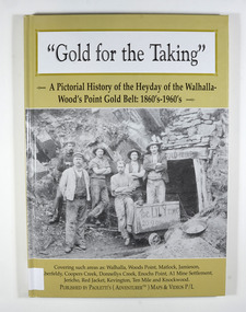
Book - Hardcover book, Gold for the Taking-A Pictorial History of the Heyday of the Walhalla-Wood's Point Gold Belt: 1860's-1960's, 2007
... gold fields... belt in the 1860's-1960's gold gold fields gold mining a1 mine ...A pictorial history of the heyday of the Walhalla-Wood's Point gold belt in the 1860's-1960'sHardcover. The cover is a gold colour. The front cover has a photograph of a group of miners in front of the entry to a mine. On the top entry timber piece is a sign saying "Old Mine". The beginning of the wording is obscured by one of the miners standing in front of the entry. There is also an old mining trolley standing on tracks which lead into the mine.There is also an old gold mining dish sitting on a rock to the left of the entry into the mine.On the back cover is a photograph of Walhalla in modern times as well as a photograph of the publisher of this book. There is also a blurb about the publisher.Stamp of the Marysville & District Historical Society Inc / P.O. Box 22 / Marysville 3779gold, gold fields, gold mining, a1 mine settlement, aberfeldy, beardmore, black river group, coopers creek, donnellys creek, enochs point, fulton creek, gaffneys creek, gooleys creek, jamieson, jordan valley, kevington, knockwood, matlock, ten mile, walhalla, wood's point, history, victoria -
Clunes Museum
Book, MC PHERSON'S PRINTING GROUP, FIELDS OF GOLD - COLLECTED WORDS
... FIELDS OF GOLD - COLLECTED WORDS...FIELDS OF GOLD- COLLECTED WORDS... FIELDS OF GOLD - COLLECTED WORDS A COLLECTION OF STORIES ...A COLLECTION OF STORIES AND VERSES BY CLUNES RESIDENTS, FROM THE VERY YOUNG TO THE ELDERLYA COLLECTION OF STORIES BY CLUNES RESIDENTS COLLECTED BY RHONDA FAWCETT WHICH COVERS MANY SUBJECTS AND EXPERIENCES FROM THE VERY YOUNG TO THE ELDERLY. GIVING A WIDE INSIGHT TO THE LIVES OF PEOPLE LIVING IN A SMALL HISTORIC COUNTRY TOWN. DARK RED COVER WITH GOLD WRITING non-fictionA COLLECTION OF STORIES AND VERSES BY CLUNES RESIDENTS, FROM THE VERY YOUNG TO THE ELDERLYfields of gold- collected words, rhonda fawcett -
Federation University Historical Collection
Journal, Exercise Books used for Newspaper article notes, 1851
... buninyong gold fields... gold fields melbourne morning herald melbourne argus dunlop ...Blue tartan covered book of lined paper with handwritten notes insidebuninyong gold fields, melbourne morning herald, melbourne argus, dunlop and regan, ballarat gold diggings, melbourne news, buninyong -
Federation University Historical Collection
Journal, Donald Douglas Mather, Exercise Books used for Newspaper article notes, 1954
... buninyong gold fields... 1968. buninyong gold fields melbourne morning herald melbourne ...Blue covered embassy exercise book of lined paper with handwritten notes inside and some loose notesHandwritten on front cover. From Donald Douglas Mather Rock St, Ivanhoe, Victoria. Ballaarat of Historical Society, Australian History from 1512 to 1890 to Keith Rash August 1968. buninyong gold fields, melbourne morning herald, melbourne argus, dunlop and regan, ballarat gold diggings, melbourne news, donald douglas mather, keith rash, james jones, gold discovery -
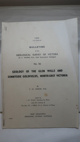 Kiewa Valley Historical Society
Document - Four Geological reports on the North-east Goldfields, Geological Survey of Victoria 1958 Bulletin
... gold fields... Alpine Area. geology in the north-east gold fields goldmines glen ...Geological Surveys of N.E. Goldfields Victoria included mines and tunnels. A resurvey of goldfields was necessary to re-assess economic possibilities using modern techniques and structural interpretation. It included an examination of a considerable surface area with maps and underground workings. Results were correlated and integrated and published by the Mines Department.The mines are in the Bogong Alpine Area.Foolscap printed Victorian Bulletins. Each stapled in the top left corner and each with varying number of pages. Covering 1941-1958 a) Glen Wills and Sunnyside b) Sunnyside Tunnel c) Red Robin d) Maud and Yellow Girl Government Printer, Mines Department, Melbourne, Victoriageology in the north-east, gold fields, goldmines, glen wills -
 The Beechworth Burke Museum
Postcard, George Symons, c.1990
... gold fields... / THE MINEHEAD C. 1872 / The easily gleaned gold of the early fields did... / The easily gleaned gold of the early fields did / not last very long ...The photograph printed on this postcard comes from the collection of the Mitchell Library in Sydney. It is sepia in tone and depicts seven men standing and sitting around a mine shaft in the Beechworth region. The photograph has been dated to approximately 1872. This period in history post-dates the Victorian gold rushes which occurred 1852-1853 in Ballarat, Bendigo and Beechworth. During this period, in the 1870s, the surface alluvial gold had been discovered and removed from location. Therefore, in order to reach the deeper and less accessible alluvial gold, diggers began to dig shafts into the earth. These shafts sunk below the ground level by 20 to 30 feet and required timber structures around the entrance and winches to bring the paydirt to the top. The top of this wooden structure is visible behind the man standing in the upper right of the image. This type of mining was highly dangerous as mines often caved in which injured the minors and often resulted in death. Thus, following this period, in the early 1900s, miners opted instead for hydrolic slucing which cut away the earth without the devastating consequences of a mine cave in. This particular group of miners appear to have been unable to afford a horse (then worth around 50 pounds) which were generally used at mines like this to help pull buckets attached to ropes up and down the mine. Instead, this group brought the buckets up and down by windlass. The windlass was a wooden structure mounted over the mining shaft and fitted with a hand-cranked winch which enabled the bucket attached to the rope to be brought up and down.Gold was first discovered in Beechworth in Spring and Reid's Creek in the summer of 1852-1853. At its popularity, this region had approximately 8000 people on the gold fields searching for gold on the banks of these creeks. These periods did not require the use of heavy machinery or the digging of deep mining shafts like the one depicted in this image. Therefore, this image has important connotations for the technologies associated with mining during the approximated 1870s when gold was harder to access. This is a later period in gold history which does not fit into the "gold rush" period. Instead, it occurred after the surface gold had disappeared and therefore, is essential for researchers who are investigating the mining techniques and structures used to reach the alluvial gold which was located deeper under ground in the 1870s. This period predates the use of big heavy machinery used to mine in the 1900s which include dredges. Images such as this one can also impart essential information as to the wardrobe and fashion of men during this period. It also imparts knowledge about the landscape of Beechworth which is useful for people researching the environment and impact of gold mining in the north-east region of Victoria. In addition, since this image is a postcard reproduction of an early Australian image which may date to approximately 1990 it can impart knowledge as to the interests of people during this time period when there may have been an increase into Australian history.A sepia tone facsimile of an early Australian photograph (circa 1872) printed as a postcard.Obverse: BEECHWORTH / Victoria, Australia / Reverse: GM 2 3275 / CORRESPONDENCE / AUSTRALIAN / YESTERYEAR / CARDS / ADDRESS / Published by George Symons (057) 65 3240 / THE MINEHEAD C. 1872 / The easily gleaned gold of the early fields did / not last very long. In order to reach less / accessible alluvial gold diggers began sinking shafts as much as twenty to thirty feet down / and the mines required timbering and winches / to bring the paydirt to the top. / This syndicate has been unable to afford the / luxury of a horse (about 50 pounds) and so everything / must go up and down by windlass and rawhide / bucket. / Photo: Mitchell Library, Sydney / A sepia tone facsimile of / an early Australian photographmining album, gold mine, beechworth, burke museum, mine shaft, postcard, australian yesteryear cards, george symons, the minehead, gold fields, alluvial gold, early australia, c.1872, 1872, gold diggers, north east victoria -
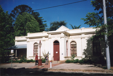 The Beechworth Burke Museum
Photograph, c1999-2000
... victorian gold fields.... Once the government centre for a vast gold fields region ...This photograph taken c1999/2000, depicts the Burke Museum’s granite façade and vestibule entrance. The museum's large red door is closed and there is a white sign is attached to the door. The museum site dates to the 1857 founding of the Beechworth Public Library and Athenaeum by a newly formed Young Men's Association (YMA). In 1863 the museum was dedicated as a memorial to former Beechworth police superintendent (1854-1858) and explorer Robert O’Hara Burke, following Burke’s death from malnutrition on the Burke and Wills expedition in 1861. Funded by the Victorian Government and the Royal Society of Victoria, the officially titled 'Victorian Exploring Expedition' was tasked with being the first European party to traverse Australia from south to north. The Burke Museum holds objects from the famous expedition and explores the multi-layered history of Beechworth and surrounds from the gold rush era to the present.This photograph is historically significant for its depiction of the Burke Museum c1999/2000. The Burke Museum is Australia’s oldest regional museum and part of Beechworth's Historic and Cultural Precinct, one of Australia’s best preserved historic-town sites and a popular tourist destination. Once the government centre for a vast gold fields region, this collection of nationally significant buildings tells the story of how Australia grew and prospered. The frequent use of honey-coloured local granite as a building material, which can be seen in the museum's fabric, gives Beechworth’s historic buildings a distinct and cohesive local character. This photograph captures this distinctive character and may be compared and studied alongside other images of historic buildings in the Burke Museum Photographic Collection.Rectangular colour photograph printed on photographic paper.Reverse: 7031 / Label: Burke Museum / 1999/2000 /burke museum, indigo shire, beechworth athanaeum, beechworth library, beechworth historic building, historic precinct, burke museum exhibition, from the liedertafel to the skating rink, honey-coloured local granite, robert o'hara burke, victorian gold fields, historic towns in victoria, colonial australia, liedertafel, colonial entertainments, beechworth brass band, historic victorian architecture, australia's oldest regional museum, burke and wills expedition, first europeans to cross australia, yound mens associations, beechworth tourism, things to see in beechworth, beechworth historic trail, young men's associations -
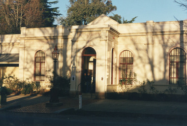 The Beechworth Burke Museum
Photograph, Unknown
... victorian gold fields... centre for a vast gold fields region, this collection ...This undated photograph depicts two people standing in the vestibule entrance at the Burke Museum, Beechworth. The museum site dates to the 1857 founding of the Beechworth Public Library and Athenaeum by a newly formed Young Men's Association (YMA). In 1863 the museum was dedicated as a memorial to former Beechworth police superintendent (1854-1858) and explorer Robert O’Hara Burke, following Burke’s death from malnutrition on the Burke and Wills expedition in 1861. Funded by the Victorian Government and the Royal Society of Victoria, the officially titled 'Victorian Exploring Expedition' was tasked with being the first European party to traverse Australia from south to north. The Burke Museum holds objects from the famous expedition and explores the multi-layered history of Beechworth and surrounds from the gold rush era to the present.This photograph is historically significant for its depiction of the Burke Museum and Loch Street streetscape. The Burke Museum is Australia’s oldest regional museum and part of Beechworth's Historic and Cultural Precinct, one of Australia’s best preserved historic-town sites and a popular tourist destination. Once the government centre for a vast gold fields region, this collection of nationally significant buildings tells the story of how Australia grew and prospered. The frequent use of honey-coloured local granite as a building material, which can be seen in the museum's fabric, gives Beechworth’s historic buildings a distinct and cohesive local character. This photograph may be compared and studied alongside other images of historic buildings in the Burke Museum Photographic Collection.Rectangular colour photograph printed on photographic paper.Reverse: 3440burke museum, beechworth athenaeum, beechworth library, beechworth historic precinct, robert o'hara burke, australia's oldest regional museum, indigo shire, beechworth athanaeum, beechworth historic building, historic precinct, honey-coloured local granite, victorian gold fields, historic towns in victoria, victoria's high country, colonial australia, beechworth tourism, things to see in beechworth, beechworth historic trail, historic victorian architecture, burke and wills expedition, first europeans to cross australia, young men's associations -
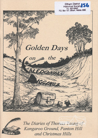 Eltham District Historical Society Inc
Book, Golden Days on the Caledonian Diggings: the diaries of Thomas Young of Kangaroo Ground, Panton Hill and Christmas Hills, compiled by Mick Woiwod, 2005
... caledonian gold fields... goldfields. thomas young caledonian gold fields kangaroo ground ...The original diaries, (1859-1866,1895-1900) of Thomas Young discovered by a Young descendant have been transcribed with the author adding his own research and historical photographs. The diary sheds light on the lives of prospectors who worked the Caledonian goldfields in the 1860s, including St Andrews and Smiths Gully. Thomas Young, migrated from Scotland and moved to the goldfields in 1858. He carted ore by horse and dray from mines around St Andrews to crushers in Panton Hill and Smiths Gully. He later became a baker. He and his wife Bridget had eleven children. He later settled at Christmas Hills establishing the local store and school. See also: "Old Diary Strikes Old" by Natalie Birch, Diamond Valley Leader August 17 2005The diary provides a rare first-hand account of life on the Caledonian goldfields.v. : ill. 69 p 30 cm[written inside front cover] To my very good friend Harry Gilham - Mick Woiwod 25th August 2005thomas young, caledonian gold fields, kangaroo ground, christmas hills, panton hill, smiths gully, st andrews, diary, gold mining -
Koorie Heritage Trust
Book, Bowden, Keith MacRae, Goldrush doctors at Ballaarat, 1977
... Doctors. Victoria. Ballarat. Gold fields.... Victoria. Ballarat. Gold fields 1850-1860. | Physicians -- Ballarat ...An historical account of events and doctors during the goldrush era at Ballarat.xiii, 125 p. : ill. (part col.), map ; 1977An historical account of events and doctors during the goldrush era at Ballarat. doctors. victoria. ballarat. gold fields, 1850-1860. | physicians -- ballarat, victoria -- history. | gold mines and mining -- victoria -- ballarat. -
 Eltham District Historical Society Inc
Folder, Victorian Goldfields Project: Historic gold mining sites in St Andrews mining division, 1999
... caledonian gold fields, caledonina gold field, david... caledonian gold fields, caledonina gold field, david bannear, gold ...Heritage site report and gazetteer by David Bannear, head consultant for archealogy for the Department of Natural Resources and Environment. Includes information on the Warrandyte Goldfield and the Caledonia Goldfield, Queenstown (now known as St Andrews), One Tree Hill, Kingston (now known as Panton Hill), Kangaroo Grounds, You You Hill, Kingstown, South Morang, Nillumbik, (now known as Diamond Creek), Steele's Creek, Yarrambet and Kinglake. Photocopy of map headed: Location of mines and reefs from Geological survey of Victoria, Yan Yean with the Diamond Creek prominant on the map. no date35 page report with map and print out of cover letter (email form) from donorcaledonian gold fields, caledonina gold field, david bannear, gold mining, harry gilham collection, queenstown, st andrews, warrandyte goldfield -
 Ballarat Heritage Services
Photograph - Image - Black and White, John Hodgson, MLC, Leading Member of the Gold Enquiry Committee, 1853
... gold fields commission... Politician gold fields commission john hodgeson ...Image of John Hodgson, a politician an committee member of the Victorian Goldfields Enquiry of 1853.john hodgson mlc, gold inquiry committee, politician, gold fields commission, john hodgeson -
 Wodonga & District Historical Society Inc
Functional object - 'Sessions' Cottage Clock c. early 20th century
... gold fields... wodonga gold rush gold fields beechworth ...This clock was produced by the American Sessions Clock Company. The company was formed in 1903, after William E. Sessions and his nephew Albert L. Sessions bought out the failing clock company of E.N.Welch Manufacturing. The clock belonged to local Wodonga bootmaker Franz Gördes (b.1843) who immigrated to Australia from Germany in 1871. After docking in Melbourne Franz headed for the goldfields in Beechworth, but didn't strike gold. He returned to his trade and opened a boot shop in Wodonga, which burnt to the ground the day before the opening. Undeterred, he rebuilt and operated the business until his death in 1928.This item has a well documented provenance and connection to the local history of Wodonga.An ornate wooden clock with Roman numeral clock face and glass door with a decorative gold transfer. clock, clocks, session clock company, wodonga, gold rush, gold fields, beechworth -
 Federation University Historical Collection
Ephemera, Various papers relating to Richard Squire Mines
... The Southern Extension of Main Ballarat Gold Fields... Ballarat Gold Fields Telegram Received Telegram Mt Mercer Lease ...In 1905 Richard Squire was manager of the West Berry Consols at Allendale, and developed an improved system of mine ventilation, which was supported in "The Age."[4] He was successful in combating and remedying the gas and ventilation troubles of the Deep Mines of Creswick and Allendale Districts after all had failed. MINE MANAGERS’ ASSOCIATION. Ballarat Branch. ... Mr R. B. Squire, manager of the West Berry Consols, at Allendale, submitted a paper detailing what he had done tor the betterment of ventilation in the alluvial mines of Smeaton and Mary borough districts- Members gave Mr Squire every credit for the results that he claimed to have effected; the adoption of his ideas had testified to their value to mine-owners. It was painted out, however, that for want of a thorough debate of the subject with experienced men the author had unwittingly included some general statements that required modifying in some points and extending in others, in justice to other workers among the earlier and the present day managers of mines. It was decided to invite the author to meet a sub-committee on this subject!Various papers relating to Richard Squire Mines including telegrams, reports, receipts, letters and newspaper clippings. .1 Souvenir Telegram .2 Telegram .3 Telegram .4 Telegram .5 Telegram .6 Telegram .7 Telegram .8 Telegram .9 Telegram .10 Telegram .11 Telegram .12 Telegram .13 Telegram .14 Telegram .15 Telegram .16 Newspaper article Mt Mercer Lease 8109, Ballarat .17 Report on the Southern Extension of Main Ballarat Goldfield .18 Letter from Harwood & Pincott Solicitors and Notaries re: Agreement .19 Ballarat Deep Leads Extensions .20 Leigh River Tunnel Syndicate Voucher x 4 .21 Debt Collector Letter .22 HY. W. Pearson Account .23 William Barrett Mining and General Blacksmith Quote and Account .24 Letter from Department of Mines, Melbourne dated 5th December 1934 .25 Letter from Mines Department, Melbourne dated 27th August 1937 .26 Documentsrelating to the purcghase of a wreath for R. Woolley .27 Prospectus of the Southern Leads .28 Propsal prospectus of Leigh River .29 Letter to Tom Squire from his brother Jim .30 Letter to Mr Squire from C Hayes regarding wages owed .31 3 copies of report on mine 8th August 1935 .32 Letter regarding unpaid account .33 Contributary causes of Collapse at Mt Mercer .34 Letter from D. Crawford re payment for timber .35 Letter from John McLeod apologising for not sending cheque .36 Letter from Department of Mines regarding Neil Cameron purchases of portions 64, 65. 66 and 71 .37 3 Letters from Department of Mines granting an extension of time to pay overdue rent. .38 Letter from Department of Mines regarding Mining Lease No. 8217 .39 Letter from Department of Mines regarding Lease Rents .40 Letter from the Department of Mines regarding further boring at Mt Mercer .41 Letter from E.R Hodge requesting that Richard Squire meet with Board members of Glenfine South .42 Letter from G Brown regarding Leases not being paid for .43 Letter from daughter Judy .44 Newspaper article regarding Berry United Deep Leads .45 Envelope addressed to R.T Squire Box 2 Tresco .46 Letter to Richard Squire from A.L. Read Date stamps richard squire, tom squire, jim squire, reports, contributary causes, account, c. hayes, proposal, prospectus, leigh river, southern leads, una cooperative society ltd., wreath, r. woolley, department of mines, e. woodlock, a.l. read, geo brown, hy. w. pearson, william barrett, ballarat deep lead extension, harwood & pincott, edmund woodlock, leigh river tunnel syndicate, federal debt collecting coy, the southern extension of main ballarat gold fields, telegram, received telegram, mt mercer lease, souvenir telegram, mining -
 The Beechworth Burke Museum
Photograph, c1920
... gold fields... rush era had on Australia and the earth. mining gold fields ...This photo shows the large mining cavity with a hydraulic sluicing machine in operation at Baarmutha Three Mile Mine, Beechworth . The Beechworth Mining District was one of six mining districts established by the Governor-in-Council on 4 January 1858 under the provisions of An Act for Amending the Laws Relating to the Goldfields (21 Vic no.32). The District was further divided into seven divisions: Spring Creek, Snake Valley, Three Mile Creek, Buckland, Woolshed, Yackandandah and Omeo. The boundaries of each of these divisions and of the whole district are described in the Governor-in-Council's proclamation printed in the Government Gazette, 5 January 1858, pages 3-5. Hydraulic mining is a form of mining that uses high-pressure jets of water to dislodge rock material or move sediment. In the placer mining of gold or tin, the resulting water-sediment slurry is directed through sluice boxes to remove the gold. It is also used in mining kaolin and coal.This photograph shows the impact the gold rush era had on Australia and the earth.A black and white rectangular photograph printed on photographic paperCopied from original on loan film (WEBB QLD) / Donated 2009 NOV/ Baarmutha Three Mile Mine c1920-1950/ Managed by John Weir Peter Jereen Jack Cox / Owned by Plain Bros then Parkinsons Sluicing.mining, gold fields, beechworth, gold rush, burke museum, photograph, mining cavity, hydraulic mining, hydraulic sluicing, baarmutha -
Eltham District Historical Society Inc
Document - Folder, Ness family
... Caledonian gold fields... gold fields Queenstown now St Andrews Mother Coleman ...James Johnston settled at Kangaroo Ground in 1849. His nephew James Mess joined him and a descendant Robert James Mess changed his surname to Ness. The family became active in all aspects of Kangaroo Ground life. Contents Text (handwritten and transcribed): "The Ness Family, Kangaroo Ground", Joy Ness, 1989. Newspaper article: "True pioneer stock", Diamond Valley News, 2 March 1982. History of the Mess/Ness family Newspaper article: "Ness family are keepers of 140 years of historical knowledge", Diamond Valley News, 4 February 1986. History of Joseph Stephenson and descendants. Newspaper article: "Joy Ness paints native flowers for posterity". Diamond Valley News, 21 October 1986. Life and career of Joy Ness as painter. Newspaper article: "His Cup runneth of with Joy", ?Diamond Valley Leader, 6 December 2000. Bruce and Joy Ness celebrate 60th wedding anniversary. Pencil sketch by Joh Ebeli no date but pre 2004: Portrait of Joy Ness dressed for the Historical Society Parade. Order of Service: Thanksgiving service for the life of Robert Bruce Ness 22 January 1917 / 28 June 2004. Eltham District Historical Society newsletter no date: "Robert Bruce Ness 1917-2004", obituary and extract from Joy Ness's history of the family. Copy of letter from Joh Ebeli to Gwen Orford, no date but ~2004: Describes drawings he made of Robert Bruce Ness when taking part in Diamond Valley Arts Society float and enclosed 3 drawings and a photograph of drawing of the bakers (corner Main Road and York Street Eltham). Eltham District Historical Society newsletter September 2013: "Vale Joy Ness", obituary and extract from Diamond Valley News article of 6 December 2000.Newspaper clippings, A4 photocopies, etcness family kangaroo ground, james johnston, kangaroo ground, pretty hill farm, wellers hotel, betsy sadler, ingleside kangaroo ground, james mess, jane stevenson, ness lane kangaroo ground, view hill kangaroo ground, stte savings bank agency, ruth lettice gosling nee mess, kangaroo ground state school, garden hills kangaroo ground, william mess, joseph mess, isabella mess, james johnson mess, ruth ettie mess, george mess, alexander mess, janes mess, robert david mess, heidelberg agricultural show, diamond creek agricultural show, rober james ness, pearl ness nee mills, william mills, sabina mills, robert bruce ness, beryl ness, vera ness, donald ness, kangaroo ground presbyterian church, kangaroo ground cemetery trust, kangaroo ground tennis club, professor osborne, doctor osborne, joseph stevenson, joy ness, kangaroo ground fire brigade, bruce ness, country fire authority, ship wellington 1837, diamond creek, david christmas, christmas hills, andres harkness, samuel furphy, andrew ross, caledonian gold fields, queenstown now st andrews, mother coleman of kangaroo ground, diamond valley arts society, winifred joy ness, andrew ross museum, eltham art show -
 Ballarat Tramway Museum
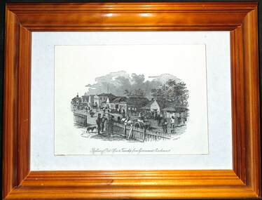
Decorative object - Framed, Samuel Thomas Gill, "Ballarat Post Office & Township from Government Enclosure", 1857
... gold fields... a busy street scene. ballarat post office gold fields Ballarat ...Ballarat's first post office was located in Ballarat East. The print is by S. t. Gill and depicts a busy street scene.Framed drawing - wooden frame with card backing and framing clips and foldout stand.ballarat, post office, gold fields, ballarat east -
Stawell Historical Society Inc
Map, 1878
... Stawell Gold Field 1878... grampians Map Stawell Gold Field 1878 Stawell Mining ...Stawell Gold Field 1878stawell, mining -
Clunes Museum
Book, JOHN TAYLOR & SON, "REPORT OF CLUNES GOLD FIELD"
... "REPORT OF CLUNES GOLD FIELD"... GOLD FIELD... "REPORT OF CLUNES GOLD FIELD" REPORTS BY THE MINING REGISTRARS ...REPORTS BY THE MINING REGISTRARS WITH MAPS OF THE CLUNES GOLD FIELDlocal history, document, book, mining -
Glenelg Shire Council Cultural Collection
Accessory - Badge - Gould League of Bird Lovers, n.d
... Red, black, white and blue enamel on gold field.... of Bird Lovers Accessory Red, black, white and blue enamel on gold ...Displayed at History House. Named to honour the work of John and Elizabeth Gould, ‘The Gould League of Bird Lovers’ (now Gould League) was formed in 1909. Originally set up to prevent bird egg collecting and to educate for the protection of Australian birds, the Gould League has made a significant impact on generations of Australians and their environmental attitudes.Red, black, white and blue enamel on gold field.Front: Gould/League of/Bird Lovers. -
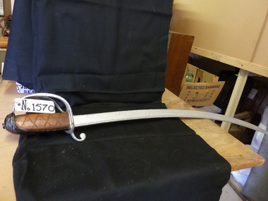 Stawell Historical Society Inc
Memorabilia - Realia, 1855
... Curved Sword. Could be troopers. Found at Deep Lead Gold... at Deep Lead Gold Fields Stawell ...Curved Sword. Could be troopers. Found at Deep Lead Gold Fields stawell -
Federation University Historical Collection
Booklet, Polling Places for the Mining District of Ballaarat Altered , 1860-1861
... Blue foolscap printed order in council under the Gold...-1861 Blue foolscap printed order in council under the Gold ...Blue foolscap printed order in council under the Gold Fields Act.mining, j.h. kay, goldfields act, j.b. humffray, polling places, voting, creswick, buninyong, ballarat, smythe's creek, blackwood, steiglitz -
Federation University Historical Collection
Booklet, Mining Under Wendouree Parade, Ballarat West, 1861
... Blue foolscap printed order in council under the Gold... the Gold Fields Act. mining J.H. Kay Wendouree Parade Goldfields ...Blue foolscap printed order in council under the Gold Fields Act.mining, j.h. kay, wendouree parade, goldfields act, j.b. humffray