Showing 668 items matching "gold field"
-
 Bendigo Regional Archives Centre
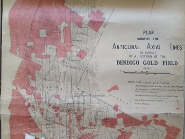
Map (item) - Plan Showing the Anticlinal Axial Lines at Surface of a Portion of the Bendigo Gold Field; E J Dunn, 5/5/1910, 5/5/1910
... Plan Showing the Anticlinal Axial Lines at Surface of a Portion of the Bendigo Gold Field; E J Dunn, 5/5/1910...Plan Showing the Anticlinal Axial Lines at Surface of a Portion of the Bendigo Gold Field; E J Dunn, 5/5/1910...E J Dunn 5/5/1910 Printed map with linen backing Plan Showing the Anticlinal Axial Lines at Surface of a Portion of the Bendigo Gold Field; E J Dunn, 5/5/1910 Map Plan Showing the Anticlinal Axial Lines at Surface of a Portion of the Bendigo Gold Field; E J Dunn, 5/5/1910 Mines Department, Victoria ...E J Dunn 5/5/1910 -
 Bendigo Historical Society Inc.
Map - BENDIGO GOLD FIELD - MAP OF PORTION OF THE BENDIGO GOLD FIELD
... BENDIGO GOLD FIELD - MAP OF PORTION OF THE BENDIGO GOLD FIELD......Bendigo Gold Field...Map showing portion of the Bendigo Gold Field showing Alluvial working, shaft sites , streets and lines of reefs.Department of Mines, Victoria. ...Blue Royal Historical Society of Victoria Bendigo Branch stamp on the back. Map BENDIGO GOLD FIELD - MAP OF PORTION OF THE BENDIGO GOLD FIELD ...Map showing portion of the Bendigo Gold Field showing Alluvial working, shaft sites , streets and lines of reefs.Department of Mines, Victoria. Many mines, lines of reefs and gullies are on the map. Blue Royal Historical Society of Victoria Bendigo Branch stamp on the back.document, bendigo gold field, department of mines, lines of reefs, gullies, mines -
 Bendigo Historical Society Inc.
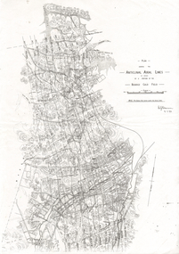
Document - LONG GULLY HISTORY GROUP COLLECTION: ANTICLINAL AXIAL LINES - BENDIGO GOLD FIELD
... LONG GULLY HISTORY GROUP COLLECTION: ANTICLINAL AXIAL LINES - BENDIGO GOLD FIELD...The Long Gully History Group - Anticlinal Axial Lines - Bendigo Gold Field...plan shewing the Anticlinal Axial lines of a portion of the Bendigo gold Field....Document LONG GULLY HISTORY GROUP COLLECTION: ANTICLINAL AXIAL LINES - BENDIGO GOLD FIELD ...plan shewing the Anticlinal Axial lines of a portion of the Bendigo gold Field.bendigo, history, long gully history group, the long gully history group - anticlinal axial lines - bendigo gold field, e j dunn, christmas line, thistle line, carshalton line, napoleon line, nell gwynne line, new chum line, sheepshead line, deborah line, garden gully line, paddy's gully line, derby line, miller's line, hustlers line, lightning line -
 Bendigo Historical Society Inc.
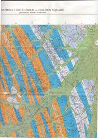
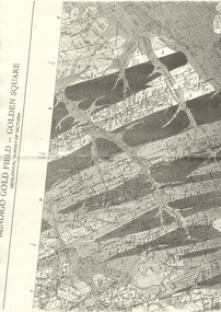
Map - STRUGNELL COLLECTION: GEOLOGICAL SURVEY OF VICTORIA, BENDIGO GOLD FIELD - GOLDEN SQUARE, 1992
... STRUGNELL COLLECTION: GEOLOGICAL SURVEY OF VICTORIA, BENDIGO GOLD FIELD - GOLDEN SQUARE.......golden square gold field...Map, Geological Survey of Victoria, Bendigo Gold Field - Golden Square, Campaspe 10 000/2.2. ...Map, Geological Survey of Victoria, Bendigo Gold Field - Golden Square, Campaspe 10 000/2.2. ...Map, Geological Survey of Victoria, Bendigo Gold Field - Golden Square, Campaspe 10 000/2.2. Victoria 10,000.Dept. 0f Manufacturinf & Industry Development.map, bendigo, golden square gold field -
 Bendigo Historical Society Inc.
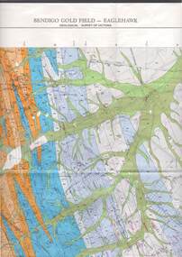
Map - STRUGNELL COLLECTION: GEOLOGICAL SURVEY OF VICTORIA, BENDIGO GOLD FIELD - EAGLEHAWK, 1992
... STRUGNELL COLLECTION: GEOLOGICAL SURVEY OF VICTORIA, BENDIGO GOLD FIELD - EAGLEHAWK......eaglehawk gold field...Map, Geological Survey of Victoria, Bendigo Gold Field - Eaglehawk.Campaspe10 000/2.3; Victoria 1:10,000. ...History House 11 Mackenzie Street Bendigo goldfields MAP Bendigo eaglehawk gold field Dept. of Manufacturing & Industry Development Map, Geological Survey of Victoria, Bendigo Gold Field - Eaglehawk.Campaspe10 000/2.3; Victoria 1:10,000. ...Map, Geological Survey of Victoria, Bendigo Gold Field - Eaglehawk.Campaspe10 000/2.3; Victoria 1:10,000. Index of Shafts.Dept. of Manufacturing & Industry Developmentmap, bendigo, eaglehawk gold field -
 Bendigo Historical Society Inc.
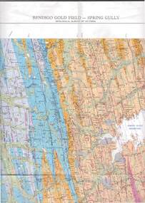
Map - STRUGNELL COLLECTION: GEOLOGICAL SURVEY OF VICTORIA, BENDIGO GOLD FIELD - SPRING GULLY, 1987
... STRUGNELL COLLECTION: GEOLOGICAL SURVEY OF VICTORIA, BENDIGO GOLD FIELD - SPRING GULLY.......spring gully gold field...Map, Geological Survey of Victoria, Bendigo Gold Field - Spring Gully, Campaspe 10 000 2/1; Victoria 10,000....Map STRUGNELL COLLECTION: GEOLOGICAL SURVEY OF VICTORIA, BENDIGO GOLD FIELD - SPRING GULLY. ...Map, Geological Survey of Victoria, Bendigo Gold Field - Spring Gully, Campaspe 10 000 2/1; Victoria 10,000.Cept. Of Industry, Technology & Resources.map, bendigo, spring gully gold field -
 Bendigo Historical Society Inc.
Map - SANDHURST GOLD FIELD SHEET NO. 1, 18th June 1873
... SANDHURST GOLD FIELD SHEET NO. 1......Sandhurst Gold Field...Map: Sandhurst Gold Field sheet No. 1, Showing lands held under lease for Gold Mining ( number 221 in Map Cupboard 1)...History House 11 Mackenzie Street Bendigo goldfields MAP Bendigo mining plan Sandhurst Gold Field Lease for Gold Mining Map: Sandhurst Gold Field sheet No. 1, Showing lands held under lease for Gold Mining ( number 221 in Map Cupboard 1) Map SANDHURST GOLD FIELD SHEET NO. 1 ...Map: Sandhurst Gold Field sheet No. 1, Showing lands held under lease for Gold Mining ( number 221 in Map Cupboard 1)map, bendigo, mining plan, sandhurst gold field, lease for gold mining -
 Bendigo Historical Society Inc.
Map - LONG GULLY HISTORY GROUP COLLECTION: BENDIGO GOLD FIELD - GOLDEN SQUARE GEOLOGICAL SURVEY OF VICTORIA
... LONG GULLY HISTORY GROUP COLLECTION: BENDIGO GOLD FIELD - GOLDEN SQUARE GEOLOGICAL SURVEY OF VICTORIA...The Long Gully History Group - Bendigo Gold Field - Golden Square Geological Survey of Victoria...Part of a map of the Bendigo Gold Field - Golden Square. Geological Survey of Victoria. ...Map LONG GULLY HISTORY GROUP COLLECTION: BENDIGO GOLD FIELD - GOLDEN SQUARE GEOLOGICAL SURVEY OF VICTORIA ...BHS CollectionPart of a map of the Bendigo Gold Field - Golden Square. Geological Survey of Victoria. Shown are reefs, faults and anticlines. Many of the mines are shown on the map. Gullies, hills and streets are also shown.bendigo, history, long gully history group, the long gully history group - bendigo gold field - golden square geological survey of victoria, north bendigo state school reserve, hospital reserve, benevolent asylum reserve, empire hill, richmond hill, raes hill, south end hill, victoria hill, new chum hill, iron bark hill, redan hill, view hill, hustlers hill, camp hill -
 Bendigo Historical Society Inc.
Map - LONG GULLY HISTORY GROUP COLLECTION: GEOLOGICAL MAP - BENDIGO GOLD FIELD
... LONG GULLY HISTORY GROUP COLLECTION: GEOLOGICAL MAP - BENDIGO GOLD FIELD...The Long Gully History Group - Geological map - Bendigo Gold Field...Copy of a Geological Map of the Bendigo Gold Field. Map shows Lines of Reef, Anticlines, Synclines, Shafts, Alluvial Contours Gullies and some street names. ...Map LONG GULLY HISTORY GROUP COLLECTION: GEOLOGICAL MAP - BENDIGO GOLD FIELD ...Copy of a Geological Map of the Bendigo Gold Field. Map shows Lines of Reef, Anticlines, Synclines, Shafts, Alluvial Contours Gullies and some street names. Copy is hard to read. There are two pages.bendigo, history, long gully history group, the long gully history group - geological map - bendigo gold field, mines department, h herman, lightning hill line, hustlers line, derby line, paddy's gully line, garden gully line, deborah line, sheepshead line, new chum line, nell gwynne line, british and foreign line, napoleon line, carshalton line, thistle line, christmas line, lancashire line -
Bendigo Historical Society Inc.
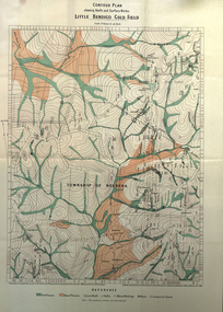
Map - RAYWOOD GOLD FIELD MAP, 1902
... RAYWOOD GOLD FIELD MAP......gold field map...Map. Raywood Gold Field Map. Linen backed map of Raywood and Neilborough Township and surrounds showing the location of varying underground workings. ...MAP gold field map Raywood Gold Field Map Neilborough H S Whitelaw Geological Survey of Victoria Bulletin No 12 Plate 11 Map. ...Map. Raywood Gold Field Map. Linen backed map of Raywood and Neilborough Township and surrounds showing the location of varying underground workings. Surveyed by H S Whitelaw 1/6/02. It shows underground workings from The Perseverance Party and moreshed and Party and underground workings on the Old Pioneer Reef. Mentions the Parish of Yallook, Parish of Neilborough, Yarraberb, Mushroom Flat, Murray Valley Plain, Eaglehawk and Kerang Railway, Green Hill, Doughboy, Redmond's Gully, Pickpocket Lead, Raywood Lead, Inglewood Lead, Shaw's Road, Nuggety Shaft, Barkly Shaft, Maori Bendmap, gold field map, raywood gold field map, neilborough, h s whitelaw, geological survey of victoria bulletin no 12 plate 11 -
 Stawell Historical Society Inc
Book, E.J. Dunn, Department of Mines Geological Survey The Stawell Gold Field - Previously Cat No 3643-1, 1909
... Department of Mines Geological Survey The Stawell Gold Field - Previously Cat No 3643-1... A short Geological analysis of the Stawell Gold Fields...Ron Wood} The Stawell Gold Field By E.J. Dunn F.G.S Replicated from the Records of the Geological Survey of Victoria, Vol III. ...Ron Wood} The Stawell Gold Field By E.J. Dunn F.G.S Replicated from the Records of the Geological Survey of Victoria, Vol III. ...A short Geological analysis of the Stawell Gold FieldsFawn Paper cover with two staples along spine1909 Victoria Department of mines (Geological Survey) {in Ink} Brought at Melbourne Mines Museum, Russell St 7.3.78. Ron Wood} The Stawell Gold Field By E.J. Dunn F.G.S Replicated from the Records of the Geological Survey of Victoria, Vol III. Part 1. By Authority J. Kemp, Government Printer, Melbourne. 7290 -2stawell mining -
 Bendigo Historical Society Inc.
Map - DEPARTMENT OF MINES VICTORIA : PLAN SHOWING PORTION OF THE BENDIGO GOLD FIELD
... DEPARTMENT OF MINES VICTORIA : PLAN SHOWING PORTION OF THE BENDIGO GOLD FIELD......Bendigo Gold Field. Gold Mining. Tyler...Plan showing portion of the Bendigo Gold Field. On the back is written, in ink, J. ...History House 11 Mackenzie Street Bendigo goldfields BENDIGO Gold mining Bendigo Gold Field. Gold Mining. Tyler J. J. Department of Mines Victoria. ...Department of Mines Victoria. Plan showing portion of the Bendigo Gold Field. On the back is written, in ink, J. J. Tyler 1937 Northern Area. (He was a teacher at Bendigo High - see donation notes). Across the bottom of the map is written ' M. Hill cr. Myrtle & Barnard' .The named reef lines have been numbered with ink across the bottom of the map. The gullies have been coloured with green pencil and a red pencil line is drawn through the western side of the map. Additional information: anticlinal axial lines at surface, alluvial workings, shaft sites, area of Main Goldfield, Deepest mine workings, Gold output of field to 1935, and Dividends paid 1870 - 1935.bendigo, gold mining, bendigo gold field. gold mining. tyler, j. j. -
Stawell Historical Society Inc
Map, Stawell Gold Field 1878, 1878
... Stawell Gold Field 1878...Stawell Gold Field 1878...Stawell Historical Society Inc 46 Longfield St Stawell grampians Stawell Mining Stawell Gold Field 1878 Stawell Gold Field 1878 Map ...Stawell Gold Field 1878stawell, mining -
 Federation University Historical Collection
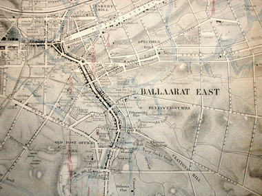
Map, Ballaarat Gold Field, 1861, 1861
... Ballaarat Gold Field, 1861......ballarat gold field 1861...Blue dots indicate gold leads, and red lines indicate auriferous quartz reef and outcrops of quartz veins. Ballaarat Gold Field, 1861 Map Geological Survey of Victoria Robert Davidson Esq C.E. ...A party of surveyors camped by Yuille's Swamp (later Lake Wendouree) and surveyed the countryside for a map to be produced by the Geological Survey of Victoria. In November 2004 the Central Highlands Regional Library presented a special edition of 200 copies of the 1861 map reproduced from a copy in their collection. Original 1861 map of Ballarat showing streets and leads. Blue dots indicate gold leads, and red lines indicate auriferous quartz reef and outcrops of quartz veins."Compiled & Drawn from the Survey of Mining Surveyors Davidson, Fitzpatrick and Cowan & the Plans in the Surveyor General's Office by J. Brahe, 21st October 1861. R. Brough Smyth, Secretary for Mines. The Honourable J.B. Humffray, M.L.A. Commr of Mines.”ballarat, map, ballarat east, lake wendouree, survey, mines, robert davidson, ballarat gold field 1861, yuille's swamp, wendouree swamp, little bendigo diggings, gold leads, old post office hill, specimen hill, bakery hill, black hill, dead horse creek, brown hill, pennyweight hill, clayton hill, soldiers hill, golden point, gum tree flat, white flat, poverty hill, chinese village, robert brough smyth, ballarat map 1861, ballaarat vineyard, dead horse gully, deadhorse creek, invermay, black hill flat, gaelic church, police reserve, magpie range, dalton's flat, caadian lead, rifle butts, powder magazine, bathing house, government camp, gold office, chinese, llanberrris, victoria theatre, charlie napier hotel, united states hotel, grape's hoel, clayton's hill, cattleyard hill, free trade hotel, esmond lead, bakery hill, black hill lead, juvenile reformatory, ballarat orphanage, lady barkly lead, triffet's slaughter yard, little bendigo, melbourne road, t. cowan, thomas cowan -
 Federation University Historical Collection
Map, Ballaarat Gold Field, 1861, 21/10/1861
... Ballaarat Gold Field, 1861......ballaarat gold field 1861...It was compiled and drawn from the surveys of Mining Surveyors Davidson, Fitzpatrick and Cowan. Ballaarat Gold Field, 1861 Map Map ...A party of surveyors camped by Yuille's Swamp (later Lake Wendouree) and surveyed the countryside for a map to be produced by the Geological Survey of Victoria. In November 2004 the Central Highlands Regional Library presented a special edition of 200 copies of the 1861 map reproduced from a copy in their collection. Original geological map of Ballarat showing property, waterways, mines, churches, schools, water races, and garden reserves. It was compiled and drawn from the surveys of Mining Surveyors Davidson, Fitzpatrick and Cowan.Compiled & Drawn from the Survey of Mining Surveyors Davidson, Fitzpatrick and Cowan & the Plans in the Surveyor General's Office by J. Brahe, 21st October 1861. R. Brough Smyth, Secretary for Mines. The Honourable J.B. Humffray, M.L.A. Commr of Mines.ballarat, map, davidson, robert brough-smyth, fitzpatrick, cowan, yuille's swamp, public garden reserve, manure depot, black hill, ballarat east, old post office hill, pennyweight hill, claytons hill, golden point, mining, railway, cricket ground, swamp creek, cemetery, sludge reserve, bakery hill, gaelic church, juvenile reformatory, orphanage, specimen hill, eureka lead, cattle yard hill, dalton's flat, chinese village, poverty hill, railway reserve, little bendigo diggings, pound reserve, allied armies, flour mill, agricultural reserve, marsh, survey reserve, survey corps, white flat, yarrowee, yarrowee creek, brache, j. brache, survey, ballaarat gold field 1861 -
Clunes Museum
Book - ADMINISTRATIVE REPORT, JOHN TAYLOR & SON, REPORT ON THE CLUNES GOLD FIELD STATE OF VICTORIA, AUSTRALIA, 1935
... REPORT ON THE CLUNES GOLD FIELD STATE OF VICTORIA, AUSTRALIA...HARDCOVER BOOK CONTAINING REPORTS BY THE MINING REGISTRARS WITH MAPS OF THE CLUNES GOLD FIELD...IN LEAD PENCIL, HANDWRITTEN: SHIRE OF TALBOT AND CLUNES COLLECTION HARDCOVER BOOK CONTAINING REPORTS BY THE MINING REGISTRARS WITH MAPS OF THE CLUNES GOLD FIELD REPORT ON THE CLUNES GOLD FIELD STATE OF VICTORIA, AUSTRALIA Book ADMINISTRATIVE REPORT JOHN TAYLOR & SON A.P. ...WRITTEN REPORT OF JOHN TAYLOR AND SONS, LONDON OF THE EXAMINATION OF THE PROPOSAL TO REOPEN THE GOLD MINES SITUATED IN THE TOWNSHIP OF CLUNES...HARDCOVER BOOK CONTAINING REPORTS BY THE MINING REGISTRARS WITH MAPS OF THE CLUNES GOLD FIELDWRITTEN REPORT OF JOHN TAYLOR AND SONS, LONDON OF THE EXAMINATION OF THE PROPOSAL TO REOPEN THE GOLD MINES SITUATED IN THE TOWNSHIP OF CLUNES...gold mining, commercial report, clunes mines to reopen, 1935 -
 Federation University Historical Collection
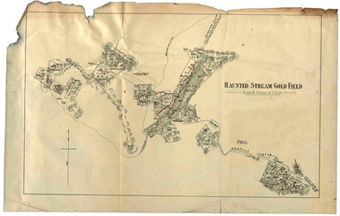
Plan, Haunted Stream Gold Field
... Haunted Stream Gold Field...Plan of the Haunted Stream Gold Field - scale 16 chains to 1 inch...haunted stream plan battery Plan of the Haunted Stream Gold Field - scale 16 chains to 1 inch Haunted Stream Gold Field Plan Plan ...Plan of the Haunted Stream Gold Field - scale 16 chains to 1 inchhaunted stream, plan, battery -
 Bendigo Historical Society Inc.
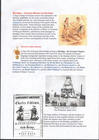
Document - German miners on the Bendigo gold field
... German miners on the Bendigo gold field. ...Two-page document which gives brief details of the German miners on the Bendigo gold field. A4 pages. Typed notes and photographs....Document German miners on the Bendigo gold field. ...Two-page document which gives brief details of the German miners on the Bendigo gold field. A4 pages. Typed notes and photographs.german miners, gold -
Bendigo Historical Society Inc.
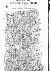
Map - GEOLOGICAL MAP BENDIGO GOLD FIELD
... GEOLOGICAL MAP BENDIGO GOLD FIELD...Geological map Bendigo gold field. Showing anticlines, synclines, shafts, alluvial, contours. ...Two originals plus two laminated copies Map GEOLOGICAL MAP BENDIGO GOLD FIELD ...Geological map Bendigo gold field. Showing anticlines, synclines, shafts, alluvial, contours. Produced by the deprtment of mines. Two originals plus two laminated copies -
 Federation University Historical Collection
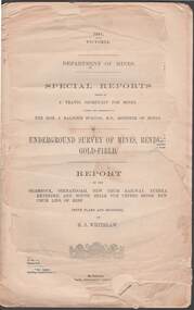
Book, Report on the Little Bendigo or Nerrena Gold-Field, Ballarat, 1901, 1901
... Report on the Little Bendigo or Nerrena Gold-Field, Ballarat, 1901...The book includes a folded, colour contour plan shewing reefs and Surface Works Little Bendigo Gold Field and an Underground Survey of Mines, Metropolitan, Monte Cristo Line...The book includes a folded, colour contour plan shewing reefs and Surface Works Little Bendigo Gold Field and an Underground Survey of Mines, Metropolitan, Monte Cristo Line Report on the Little Bendigo or Nerrena Gold-Field, Ballarat, 1901 Book Robert Brain, Government Printer ...Blue soft covered foolscap book of 4 pages. The book includes a folded, colour contour plan shewing reefs and Surface Works Little Bendigo Gold Field and an Underground Survey of Mines, Metropolitan, Monte Cristo Linelittle bendigo, nerrena, h.s. whitelaw, william baragwanath, geology, monte christo, monte cristo, neerena, nerrina, plans, mining cgt -
Bendigo Historical Society Inc.
Map - GEOLOGICAL MAP OF BENDIGO GOLD FIELD
... GEOLOGICAL MAP OF BENDIGO GOLD FIELD...Map of Bendigo gold field showing anticlines, synclines, shaft, alluvial deposits and contour lines. ...Map GEOLOGICAL MAP OF BENDIGO GOLD FIELD ...Map of Bendigo gold field showing anticlines, synclines, shaft, alluvial deposits and contour lines. Map is in two sections. This map forms part of the Geological Survey of Victoria, Structure of Bendigo Goldfield report, No. 47, 1923. H.Herman, late Director of Geological Survey.Geological Survey Victoriabendigo, gold mining, geological map -
 Bendigo Historical Society Inc.
Document - STRUGNELL COLLECTION: UNDERGROUND SURVEY OF MINES: BENDIGO GOLD-FIELD, 1901
... STRUGNELL COLLECTION: UNDERGROUND SURVEY OF MINES: BENDIGO GOLD-FIELD...Document, Underground Survey of Mines, Bendigo Gold-Field, Department of Mines, Special Reports on the Shamrock, Shenandoah, New Chum Railway, Eureka Extended, and South Belle Vue United Mines, New Chum Line of Reef, by H.S.Whitelaw.dated 1901.Issued by J.Travis , Secretary for Mines...History House 11 Mackenzie Street Bendigo goldfields DOCUMENT underground survey of mines H.S.Whitelaw -Herbert Staney Whitelaw Document, Underground Survey of Mines, Bendigo Gold-Field, Department of Mines, Special Reports on the Shamrock, Shenandoah, New Chum Railway, Eureka Extended, and South Belle Vue United Mines, New Chum Line of Reef, by H.S.Whitelaw.dated 1901.Issued by J.Travis , Secretary for Mines Document STRUGNELL COLLECTION: UNDERGROUND SURVEY OF MINES: BENDIGO GOLD-FIELD ...Document, Underground Survey of Mines, Bendigo Gold-Field, Department of Mines, Special Reports on the Shamrock, Shenandoah, New Chum Railway, Eureka Extended, and South Belle Vue United Mines, New Chum Line of Reef, by H.S.Whitelaw.dated 1901.Issued by J.Travis , Secretary for Minesdocument, underground survey of mines, h.s.whitelaw -herbert staney whitelaw -
Bendigo Historical Society Inc.
Map - BENDIGO GOLD FIELD LONGITUDINAL VERTICAL PROJECTIONS
... BENDIGO GOLD FIELD LONGITUDINAL VERTICAL PROJECTIONS...Bendigo gold field map showing vertical projections of portions of three anticlinal axial planes showing stratigraphical zones and caps of known saddle reefs. ...H.Herman, late Director of Geological Survey. Map BENDIGO GOLD FIELD LONGITUDINAL VERTICAL PROJECTIONS ...Bendigo gold field map showing vertical projections of portions of three anticlinal axial planes showing stratigraphical zones and caps of known saddle reefs. This map forms part of the Geological Survey of Victoria, Structure of Bendigo Goldfield report, No. 47, 1923. H.Herman, late Director of Geological Survey.Geological Survey Victoriabendigo, gold mining, vertical projections, bendigo, goldfield, gold mining, reef lines, mining companies, geological survey -
Bendigo Historical Society Inc.
Map - BENDIGO GOLD FIELD GEOLOGICAL MAP, 1923
... BENDIGO GOLD FIELD GEOLOGICAL MAP...Geological map of the Bendigo Gold Field showing stratigraphical zones. Map in two sections, colour coded showing anticlines, synclines, shafts, fault lines, fossils. ...H.Herman, late Director of Geological Survey. Map BENDIGO GOLD FIELD GEOLOGICAL MAP ...Geological map of the Bendigo Gold Field showing stratigraphical zones. Map in two sections, colour coded showing anticlines, synclines, shafts, fault lines, fossils. Signed by H. Herman. This map forms part of the Geological Survey of Victoria, Structure of Bendigo Goldfield report, No. 47, 1923. H.Herman, late Director of Geological Survey.Geological Survey Victoriabendigo, gold mining, geological map -
Bendigo Historical Society Inc.
Map - BENDIGO GOLD FIELD GEOLOGICAL MAP
... BENDIGO GOLD FIELD GEOLOGICAL MAP...Geological map of the Bendigo Gold Field showing stratigraphical zones. Map in two sections, colour coded showing anticlines, synclines, shafts, fault lines, fossils. ...H.Herman, late Director of Geological Survey. Map BENDIGO GOLD FIELD GEOLOGICAL MAP ...Geological map of the Bendigo Gold Field showing stratigraphical zones. Map in two sections, colour coded showing anticlines, synclines, shafts, fault lines, fossils. Signed by H. Herman. This map forms part of the Geological Survey of Victoria, Structure of Bendigo Goldfield report, No. 47, 1923. H.Herman, late Director of Geological Survey.Geological Survey Victoriabendigo, gold mining, geological map -
 Federation University Historical Collection
Book, Report on the Ballarat East Gold-Field, 1894 and Ballarat East Gold-Field, 1907, 1894
... Report on the Ballarat East Gold-Field, 1894 and Ballarat East Gold-Field, 1907...Report on the Ballarat East Gold-Field, 1894 and Ballarat East Gold-Field, 1907 Book Book Robert Brain, Government Printer Ernest Lidgey J.W. ...The Ballarat Ironworkers' and Polytechnic Association was at the Ballarat School of Mines. In 1907 J.W. Gregory Professor of Geology at Glasgow Univesity, Late Director of the geological Survey of Victoria and Professor of Geology at Melbourne University. W. Dickson was Secretary for Mines and Donald McLeod was the Minister of Mines. in 1894 Ernest Lidgey was the Assistant Geological Surveyor for the Victorian Department of Mines. A.W. Howitt was Secretary for Mines and Henry Foster was the Minister of Mines. Charcoal hard covered report on the Ballarat East Goldfield. The book combines two reports from the Victorian Department of Mines. The 1894 report is 52 pages and includes images and plans. The 1907 Report is number 4 in the Memoirs of the Geological Survey of Victoria. Photographs include Looking South from the Britannia Mullock Heap, View from Sovereign Hill, Golden Point gold discovery site.Stamped "Ballarat Ironworkers' Association School of Mines" Bookplate of the Ballarat Ironworkers' and Polytechnic Association. Written inside front cover: "S.J. Miller, 115 Ascot Street, Ballarat"ballarat ironworkers' and polytechnic association, ballarat school of mines, ironworkers, geology, mining, ballarat east, llanberris, victoria united mine, normanby, north woah hawp, bookplate, s.j. miller, library plate, golden point, gold discovery at golden point, new normanby mine, william baragwanath, new speedwell, britannia united, llanberris co, sulieman pasha, prince regent, dalzell-cum-prince regent, north prince extended, eastern star, f. gray, victoria united gold mine, sovereign hill mine, prince regent mine, britannia mine -
Bendigo Historical Society Inc.
Map - GEOLOGICAL MAP OF BENDIGO GOLD FIELD
... GEOLOGICAL MAP OF BENDIGO GOLD FIELD...On map(a) written in black on top: 'Geological Map, Bendigo Gold Field', Scale of chains, anticlines, synclines, shafts, alluvial and contours marked. ...Map GEOLOGICAL MAP OF BENDIGO GOLD FIELD ...Two framed laminated maps (a,b) of Bendigo goldfield reef lines, map (b) is a continuation of the reef lines in map (a). On map(a) written in black on top: 'Geological Map, Bendigo Gold Field', Scale of chains, anticlines, synclines, shafts, alluvial and contours marked. Map (b) is continuation of (a). Written on the bottom RH corner of map: 'Prepared in 1923 in the Bendigo Office Mines Department under the direction of H. Herman, Director of Geological Surveys, from surveys by H.S. Whitelaw, Fiield Geologist, assisted by E.S. Usher & J. J. Moore. Re-issued in 1936.'H. Herman, Director of Geological Surveys, from surveys by H.S. Whitelaw, Fiield Geologist, assisted by E.S. Usher & J. J. Moore. Re-issued in 1936.'bendigo, mining, geological map. -
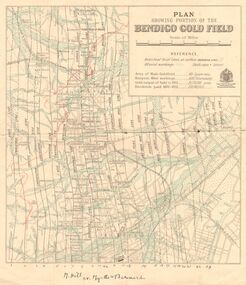
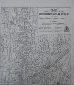 Bendigo Historical Society Inc.
Map - Bendigo Gold Field
... Bendigo Gold Field...Deepest mine working: 4593' (Victoria quartz). Gold output of field to 1935: 20,775,000 ounces. Dividends paid 1870-1935: 10,740,000 pounds....Map Bendigo Gold Field ...Plan showing portion of the Bendigo goldfield. Area of main goldfield: 140 square miles. Deepest mine working: 4593' (Victoria quartz). Gold output of field to 1935: 20,775,000 ounces. Dividends paid 1870-1935: 10,740,000 pounds.map, goldfield, bendigo -
 Ringwood and District Historical Society
Booklet - Newsletter, Warrandyte Historical Society Inc. - Louis John Michel, Discoverer of the First Payable Gold Field in Victoria, 1979
... . - Louis John Michel, Discoverer of the First Payable Gold Field in Victoria.... - Louis John Michel, Discoverer of the First Payable Gold Field in Victoria Booklet Newsletter Evelyn J Cooke ...Letter and article entitled "MICHEL" by Mrs. Evelyn J. Cooke - Article written by his great granddaughter, addressed to Mrs Jo Laurence of the Warrandyte Historical Society. -
 Ringwood and District Historical Society
Booklet - Newsletter, Warrandyte Historical Society Inc. - The First Gold Field in Victoria - How l discovered it, by Louis John Michel, 1896
... Warrandyte Historical Society Inc. - The First Gold Field in Victoria - How l discovered it, by Louis John Michel....Ringwood and District Historical Society 125A Warrandyte Road Ringwood North melbourne Personal recollections of Louis John Michel after the events which he described in The Argus on Saturday 28 December 1895 Warrandyte Historical Society Inc. - The First Gold Field in Victoria - How l discovered it, by Louis John Michel. ...Personal recollections of Louis John Michel after the events which he described in The Argus on Saturday 28 December 1895