Showing 330 items matching "goldfields region"
-
 Federation University Historical Collection
Booklet, Social Fabric - Past to Future: Celebrating 100 years of women's sufferage in the central goldfields region of Victoria 1908 - 2008
... Social Fabric - Past to Future: Celebrating 100 years of women's sufferage in the central goldfields region of Victoria 1908 - 2008...A5 booklet titled Social Fabric - Past to Future: Celebrating 100 years of women's sufferage in the central goldfields region of Victoria wth photograph of two women having a cup of tea on the front cover....Social Fabric - Past to Future: Celebrating 100 years of women's sufferage in the central goldfields region of Victoria 1908 - 2008 Booklet ...A5 booklet titled Social Fabric - Past to Future: Celebrating 100 years of women's sufferage in the central goldfields region of Victoria wth photograph of two women having a cup of tea on the front cover.social fabric - past to future, women's sufferage, elizabeth ann hooke buchan, sarah jane dunstone, helen hunt, bessie lee, cecille bucknall joyce, annie lowe, reverend henry greenwood, george chessell, reverend brian wibberley, james blackburne, helen hart, j.c.f. ulbrich, james hugh gearing, alfred outtrim, eliza hubble, emily h. colman, e.r. edwards, j.b. edwards, annie c. stubbs, harriet a. stubbs, eliz. a stubbs, h. toole, mrs waddell, mary haylock, mary hill -
Federation University Historical Collection
Report, Cindy Ross, An Integrated Tourism Strategy Plan for the Goldfields Region: Community/Industry Research and Analysis, 1994, 03/10/1994
... An Integrated Tourism Strategy Plan for the Goldfields Region: Community/Industry Research and Analysis, 1994...Barker Library (top floor) Mount Helen goldfields victorian tourisim industry tourism victorian goldfields michael pearlman anastasia molloy ballarat bendigo maldon maryborough castlemaine goldfield tourism avoca daylesford Yello report complied by four students of Tourism at the University of Ballarat An Integrated Tourism Strategy Plan for the Goldfields Region: Community/Industry Research and Analysis, 1994 Report Cindy Ross Kylie Clark Debra Lewis Jeanene Simmons ...Yello report complied by four students of Tourism at the University of Ballarat victorian tourisim industry, tourism, victorian goldfields, michael pearlman, anastasia molloy, ballarat, bendigo, maldon, maryborough, castlemaine, goldfield tourism, avoca, daylesford -
Federation University Historical Collection
Report, Integrated Tourism Strategy Plan for the Goldfields Region of Victoria: Volume II: Appendices - Miscellaneous, 10/1995
... Integrated Tourism Strategy Plan for the Goldfields Region of Victoria: Volume II: Appendices - Miscellaneous...Integrated Tourism Strategy Plan for the Goldfields Region of Victoria: Volume II: Appendices - Miscellaneous Report J.T. ...Black plastic ring binding on an A4 report.goldfields of victoria, goldfields tourism, marketing, goldfields campaign, mining tourism, torusim, tourism strategy, ballarat, bendigo, avoca, maryborough, castlemaine, maldon, community survey -
Federation University Historical Collection
Report, Integrated Tourism Strategy Plan for the Goldfields Region of Victoria, 1994
... Integrated Tourism Strategy Plan for the Goldfields Region of Victoria...Integrated Tourism Strategy Plan for the Goldfields Region of Victoria Report Kylie Clark Cindy Ross Debra Lewis Jeanene Simmons ...Black ring binding on an A4 report.goldfields of victoria, goldfields tourism, marketing, goldfields campaign, mining tourism, torusim, tourism strategy, ballarat, bendigo, avoca, maryborough, castlemaine, maldon, community survey, michael pearlman, anastasia molloy, jack harvey, avoca -
Federation University Historical Collection
Report, Emma Nuttall, Goldfields Consultancy Proposal, 2002-5, 1995
... .1) Strategic Plan for Goldfields Region: Consultancy Proposal .2) A Strategic Marketing Plan by four students of Tourism at the University of Ballarat relating to Victoria's Goldfields Region....Barker Library (top floor) Mount Helen goldfields victorian tourisim industry tourism goldfields victorian goldfields .1) Strategic Plan for Goldfields Region: Consultancy Proposal .2) A Strategic Marketing Plan by four students of Tourism at the University of Ballarat relating to Victoria's Goldfields Region. ....1) Strategic Plan for Goldfields Region: Consultancy Proposal .2) A Strategic Marketing Plan by four students of Tourism at the University of Ballarat relating to Victoria's Goldfields Region.victorian tourisim industry, tourism, goldfields, victorian goldfields -
Federation University Historical Collection
Report, Goldfields Consultancy Proposal, c2002
... A report by four students of Tourism at the University of Ballarat relating to Victoria's Goldfields Region....Barker Library (top floor) Mount Helen goldfields victorian tourisim industry tourism goldfields victorian goldfields A report by four students of Tourism at the University of Ballarat relating to Victoria's Goldfields Region. Goldfields Consultancy Proposal Report Mary Hollick Sheridan Bent Elissa McBain Andrea Jewell Lisa Tuckett ...A report by four students of Tourism at the University of Ballarat relating to Victoria's Goldfields Region.victorian tourisim industry, tourism, goldfields, victorian goldfields -
Federation University Historical Collection
Report, Goldfields Consultancy Proposal, 2002-5, c2002
... A strategic Marketing Plan by four students of Tourism at the University of Ballarat relating to Victoria's Goldfields Region....Barker Library (top floor) Mount Helen goldfields victorian tourisim industry tourism goldfields victorian goldfields bendigo ballarat avoca castlemaine maldon maryborough clunes dunolly creswick A strategic Marketing Plan by four students of Tourism at the University of Ballarat relating to Victoria's Goldfields Region. Goldfields Consultancy Proposal, 2002-5 Report ...A strategic Marketing Plan by four students of Tourism at the University of Ballarat relating to Victoria's Goldfields Region.victorian tourisim industry, tourism, goldfields, victorian goldfields, bendigo, ballarat, avoca, castlemaine, maldon, maryborough, clunes, dunolly, creswick -
 Bendigo Historical Society Inc.
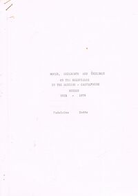
Document - WOMEN, CHILDBIRTH AND CHILDREN ON THE GOLDFIELDS: BENDIGO AND CASTLEMAINE REGION 1851 TO 1876)
... WOMEN, CHILDBIRTH AND CHILDREN ON THE GOLDFIELDS: BENDIGO AND CASTLEMAINE REGION 1851 TO 1876)...''Women, childbirth and children on the Goldfields in the Bendigo-Castlemaine Region 1851-1876)'' author Madeleine Dodds. ...Document WOMEN, CHILDBIRTH AND CHILDREN ON THE GOLDFIELDS: BENDIGO AND CASTLEMAINE REGION 1851 TO 1876) ...''Women, childbirth and children on the Goldfields in the Bendigo-Castlemaine Region 1851-1876)'' author Madeleine Dodds. Two copies a. and b. -one copy is double sided printing; other is single sided. Mention of Boyd and Harris Dispensary; Holloway products; Bendigo Benevolent Asylum; Industrial School; Lying -in Wing; Jabez Hogg Medical Guide; Doctor Jenkins, Dr Richard Tracy, Traces the history of early births and childcare on the goldfields. Bibliography.Madeleine Doddsbendigo, mining, women and children on the goldfields, boyd and harris dispensary, holloway products, dr. jenkins, jabez hogg medical guide, dr richard tracy, bendigo benevolent society. women, childbirth, children. -
Federation University Historical Collection
Book, Wendy Liddell, Her Majesty's Development of Theatre Tourism Packages 1998, 1998
... ...goldfields region...Barker Library (top floor) Mount Helen goldfields This project was completed in two phases: Phase 1 - Segmentation Study Phase 2 - Product Development introduction & objectives methodology analysis & findings/results - phase 1: segmentation study analysis & findings/results - phase 2: product development conclusions & recommendations review & evaluation of the project assessment of the industrial experience & learning experience ballarat mildura tourism victoria roy morgan segments goldfields region craig's royal hotel ballarat fine art gallery her majesty's theatre peter freund janice haynes wendy liddell lynne mclennan peter morey barb dunlop wendy hall colin benjamin julie jewell ian hamilton janet reynolds Her Majesty's Theatre Ballarat theatre entertainment performing arts White soft covered book of 34 pages with 22 appendices. ...This project was completed in two phases: Phase 1 - Segmentation Study Phase 2 - Product DevelopmentWhite soft covered book of 34 pages with 22 appendices. It includes pull out brochures and leaflets.introduction & objectives, methodology, analysis & findings/results - phase 1: segmentation study, analysis & findings/results - phase 2: product development, conclusions & recommendations, review & evaluation of the project, assessment of the industrial experience & learning experience, ballarat, mildura, tourism victoria, roy morgan segments, goldfields region, craig's royal hotel, ballarat fine art gallery, her majesty's theatre, peter freund, janice haynes, wendy liddell, lynne mclennan, peter morey, barb dunlop, wendy hall, colin benjamin, julie jewell, ian hamilton, janet reynolds, her majesty's theatre ballarat, theatre, entertainment, performing arts -
 Victorian Aboriginal Corporation for Languages
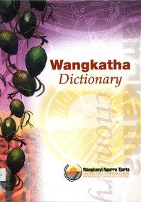
Book, Wangkanyi Ngurra Tjurta Aboriginal Corporation Language Centre, Wangkatha dictionary, 2002
... ...Goldfields region...Victorian Aboriginal Corporation for Languages 33 Saxon Street Brunswick melbourne Ngadju Tjuparn Ngalia Kuwarra Mirning Gubrun Ngaanyatjarra Wangkatha Martu Pitjatjatjarra Wangkatha Western Australia Goldfields region B&w illustrations, maps, word lists Wangkatha-English dictionary with English-Wangkatha finder list; pronunciation guide and some thematic-based wordlists, e.g. body parts. ...Wangkatha-English dictionary with English-Wangkatha finder list; pronunciation guide and some thematic-based wordlists, e.g. body parts.B&w illustrations, maps, word listsngadju, tjuparn, ngalia, kuwarra, mirning, gubrun, ngaanyatjarra, wangkatha, martu, pitjatjatjarra, wangkatha, western australia, goldfields region -
Clunes Museum
Pamphlet - BROCHURE
... COLOURED BROCHURE IN CARDBOARD COVER, PROMOTING THE CENTRAL VICTORIAN GOLDFIELDS TOURIST REGION...Clunes Museum 36 Fraser Street enter building through Collins Place Clunes goldfields BROCHURE PRODUCED BY VICTORIAN TOURISM COMMISSION TO PROMOTE CENTRAL VICTORIAN GOLDFIELDS local history documents pamphlets SEE OVER COLOURED BROCHURE IN CARDBOARD COVER, PROMOTING THE CENTRAL VICTORIAN GOLDFIELDS TOURIST REGION Pamphlet BROCHURE ...BROCHURE PRODUCED BY VICTORIAN TOURISM COMMISSION TO PROMOTE CENTRAL VICTORIAN GOLDFIELDSCOLOURED BROCHURE IN CARDBOARD COVER, PROMOTING THE CENTRAL VICTORIAN GOLDFIELDS TOURIST REGIONSEE OVERlocal history, documents, pamphlets -
 Bendigo Historical Society Inc.
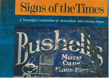
Book - Signs of the Times
... His work reflects a passion for the heritage of the goldfields region. https://artsopen.com.au/wp-content/uploads/2021/11/geoff-hocking-CV-2019.pdf ...His work reflects a passion for the heritage of the goldfields region. https://artsopen.com.au/wp-content/uploads/2021/11/geoff-hocking-CV-2019.pdf Signs Geoff Hocking Photographs Advertising Full title. ...Well-known as an artist, author, historian, illustrator and publisher, Geoff Hocking grew up in the goldfields city of Bendigo and lives today in Castlemaine. His work reflects a passion for the heritage of the goldfields region. https://artsopen.com.au/wp-content/uploads/2021/11/geoff-hocking-CV-2019.pdf Full title. "Signs of the Times. A nostalgic Celebration of Australian Advertising Signs. Written by Geoff Hocking. Published by Five Mile Press in 2007. Hard cover book with dust jacket. Blue and gold colouring. Front cover has a picture of a Bushells sign on a brick wall with a peters Ice cream sign in the corner. Back cover has eight smaller advertising signs. 228 pp. containing advertising signs from across Australia with historical notes and descriptions.signs, geoff hocking, photographs, advertising -
 Bendigo Historical Society Inc.
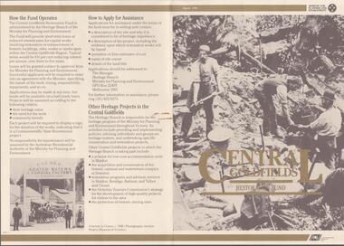
Document - CENTRAL GOLDFIELDS RESTORATION FUND, March 1986
... Includes a map of the central goldfields region, introduction by Jim Kennan (Minister) and 3 photographs. ...Includes a map of the central goldfields region, introduction by Jim Kennan (Minister) and 3 photographs. ...Pamphlet on the Central Goldfields Restoration Fund issued by the Victorian Ministry for Planning and Environment. Includes a map of the central goldfields region, introduction by Jim Kennan (Minister) and 3 photographs. Also a description on how the fund operates and how to apply for assistance. An insert of 2 blank application forms. Photos show , Miners using a sluice at Tarnagulla c.1880. Cnr of Sturt and Lydiard Sts, Ballarat c.1880. E. Eberhard Cordial Factory at Clunes c.1890.Victorian Ministry for Planning and Environmentorganization, government, central goldfields, restoration fund, ministry for planning and environment, j. kennan, tarnagulla, ballarat, clunes. -
 Bendigo Historical Society Inc.
Newspaper - Fortuna Articles - "Steeped in Mystery", Dec 01 2007
... This document explores the myths, legends, and mysterious phenomena of the Goldfields region in Australia, focusing on several recurring themes: Numerous reports of large, exotic cats (such as black panthers and pumas) have been recorded in Victoria, with over 4,500 sightings documented by the Australian Rare Fauna Research Association since 1984.Notable individuals, like John Higgins and Paul Clacher, have provided detailed accounts and physical evidence (e.g., large footprints) supporting the existence of these animals. ...This document explores the myths, legends, and mysterious phenomena of the Goldfields region in Australia, focusing on several recurring themes: Numerous reports of large, exotic cats (such as black panthers and pumas) have been recorded in Victoria, with over 4,500 sightings documented by the Australian Rare Fauna Research Association since 1984.Notable individuals, like John Higgins and Paul Clacher, have provided detailed accounts and physical evidence (e.g., large footprints) supporting the existence of these animals. ...This document explores the myths, legends, and mysterious phenomena of the Goldfields region in Australia, focusing on several recurring themes: Numerous reports of large, exotic cats (such as black panthers and pumas) have been recorded in Victoria, with over 4,500 sightings documented by the Australian Rare Fauna Research Association since 1984.Notable individuals, like John Higgins and Paul Clacher, have provided detailed accounts and physical evidence (e.g., large footprints) supporting the existence of these animals. Theories about their origins include escaped zoo or circus animals, mascots released by American servicemen after WWII, or even the survival of the supposedly extinct Thylacoleo (Marsupial Lion). The Goldfields are reputed to be home to many ghosts, with frequent reports from locations such as Camp Hill Primary School, Castlemaine's Theatre Royal, and especially the historic Fortuna Villa.Accounts from both military personnel and civilians describe unexplained voices, apparitions, and other paranormal events within these historic buildings. Specific stories include encounters with apparitions, mysterious voices, and doors opening on their own, often witnessed by credible sources like army sergeants and captains. The document also references other unexplained phenomena in the region, such as UFO sightings and missing people, contributing to the area's reputation for mystery and intrigue.Fortuna Article - "Steeped in Mystery" Dec 01 2007 by Sarah Harris This item contains the following: 11217.33a Colour Photo of Fortuna, once home to the Lansell family, Fortuna Villa is now occupied by the Department of Imagery and Geospatial Organistion mapping unit, and apparently, some apparitions 11217.33b Colour Photo of Russel Henthorn with his camera and gear he used for a UFO photo in 1983 11217.33c Part of Page 4 - Article "Steeped in Mystery" non-fictionbendigo, fortuna, george lansell, russell henthorn -
 Ballarat Heritage Services
Photograph, Talbot Primative Church, c2014
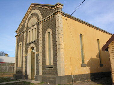
... The bluestone church building, a distinctive example of Romanesque design, now houses a wide array of historical exhibits about the region's goldfields history, including mining relics, photographs, documents, and communications equipment. ...Ballarat Heritage Services PO Box 2209 Bakery Hill Post Office goldfields The Talbot Primitive Methodist refers to a former Primitive Methodist Church in Talbot, Victoria, Australia, that was built in 1870 and is now the home of the Talbot Arts & Historical Museum. The bluestone church building, a distinctive example of Romanesque design, now houses a wide array of historical exhibits about the region's goldfields history, including mining relics, photographs, documents, and communications equipment. ...The Talbot Primitive Methodist refers to a former Primitive Methodist Church in Talbot, Victoria, Australia, that was built in 1870 and is now the home of the Talbot Arts & Historical Museum. The bluestone church building, a distinctive example of Romanesque design, now houses a wide array of historical exhibits about the region's goldfields history, including mining relics, photographs, documents, and communications equipment. The building is recognized for its sophisticated and relatively large Romanesque design, featuring a novel facade combining elements of a Classical temple front and a Roman triumphal arch. FoColour photographs of Talbot Primative Church.talbot, primartive methodist church, talbot museum -
 City of Moorabbin Historical Society (Operating the Box Cottage Museum)
Functional object - Kitchen Equipment, Coolgardie Safe, c1900
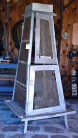
... Coolgardie is in the Eastern Goldfields region of Western Australia. Gold was first discovered there in 1892; the townsite became a municipality in 1894, and by 1898 its population of 15,000 made it the third largest town in Western Australia after Perth and Fremantle. ...Coolgardie is in the Eastern Goldfields region of Western Australia. Gold was first discovered there in 1892; the townsite became a municipality in 1894, and by 1898 its population of 15,000 made it the third largest town in Western Australia after Perth and Fremantle. ...The invention of the Coolgardie Safe is credited to Arthur Patrick McCormick, a contractor in Coolgardie, and later the Mayor of Narrogin. Coolgardie is in the Eastern Goldfields region of Western Australia. Gold was first discovered there in 1892; the townsite became a municipality in 1894, and by 1898 its population of 15,000 made it the third largest town in Western Australia after Perth and Fremantle. In the last decade of the 19th century, Coolgardie was the capital of the West Australian goldfields. Being 180 kilometres from the nearest civilisation, food supplies were initially scarce and expensive. As fresh food was a valuable commodity there was incentive to preserve it, and keep it out of reach of scavengers such as birds, dingos, dogs, ants, and flies. It was in an effort to do this, in the extreme heat of the Australian Interior, that McCormick came up with his design for the Coolgardie Safe. McCormick noticed that a wet bag placed over a bottle cooled its contents. He further noted that if this bottle was placed in a breeze, the bag would dry out more quickly, but the bottle would get colder. What McCormick had discovered was the principle of evaporation: ‘to change any liquid into a gaseous state requires energy. This energy is taken in the form of heat from its surroundings.’ Employing this principle, McCormick made a box for his provisions which he covered with a wet hessian bag. He then placed a tray on top, into which he poured water twice daily. He hung strips of flannel from the tray so that water would drip down onto the hessian bag, keeping it damp. As the water evaporated, the heat dissipated, keeping the food stored inside cool and fresh. The success of McCormick’s invention would not have worked without a steady supply of water. Fresh water was scarce in the eastern goldfields at this time but the demand for water from a steadily growing population encouraged innovation. The solution was to condense salt water. Heating salt water in tanks produced steam that was condensed in tall cylinders, cooled and then collected in catchment trays. By 1898 there were six companies supplying condensed water to the goldfields, the largest company producing 100,000 gallons of water a day. In the early 20th century, Coolgardie Safes were also manufactured commercially. These safes incorporated shelving and a door, had metal or wooden frames and hessian bodies. The feet of the safe were usually placed in a tray of water to keep ants away. (MAV website) The early settlers of Moorabbin Shire depended on this type of Food Safe to protect their food from flies and vermin as they established market gardens in the fertile area around the notorious Elster Creek A metal framed, 4 sided structure standing on 4 legs with 2 hinged doors on one side, a metal tray at base of food safe and a metal cover over top. Ridges on which to rest trays carrying food are inside safe. The Safe is enclosed by fly-wire mesh.'...IN.....GEELONG' A manufacturer's oval metal plate is embossed on one side of Safe but it is illegible.elster creek, moorabbin, brighton, dendy's special survey 1841, market gardens, infant mortality, disease, cemeteries, fruit, vegetables, pioneers, coolgardie safe, mccormick arthur patrick, dendy henry, vaccination, jones martha, jones ethel may -
 Bendigo Historical Society Inc.
Slide - Images by Arthur Pulfer, 1957-1970
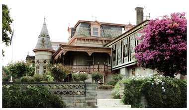
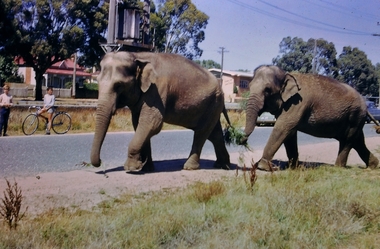
... It is one of the few Streamline Moderne houses in the Central Goldfields region, and was one of the earliest constructed in the Bendigo region. ...It is one of the few Streamline Moderne houses in the Central Goldfields region, and was one of the earliest constructed in the Bendigo region. ...Arthur William Pulfer was born on 18 April 1918, in Bendigo, Victoria, Australia, his father, Harold Victor Pulfer, was 30 and his mother, Elsie Maud Rumball, was 26. He married Norma Stewart in Bendigo, Victoria, Australia. He died on 6 March 2001, in his hometown, at the age of 82, and was buried in the Bendigo Cemetery. ROSEVIEW 407 High Street, Golden Square Bendigo "Roseview" was designed by Godfrey Eathorne and constructed in 1939. It is one of the few Streamline Moderne houses in the Central Goldfields region, and was one of the earliest constructed in the Bendigo region. It is an outstanding example of this style of housing. It resembles an ocean liner, and reflects the emphasis on the streamlining of methods of transportation. It utilizes both flat and curved surfaces and has little external ornamentation. The use of materials such as rounded glass windows and metal window and door frames reflects an innovative approach to construction consistent with the style. "Roseview" was constructed on a large scale, with large and spacious rooms. It reflects the prominent social status and wealth of the original owner, together with the desire for a building in 'the latest' style which was sure to attract attention and prominence in the region. It has been maintained largely in original condition. CARALULUP HOTEL 'The Sun' dated January 17, 1941 on the back. It states that 'The licence of Caralulup Hotel, near Talbot, has been surrendered, thus severing an 80 year association with the district' State Library of Victoria TOLMER GOLD ESCORT ROUTE The gold rush in New South Wales and Victoria left few able miners in South Australia. Bad economic conditions saw more than 15,000 men leave the Kapunda and Burra mines by the end of 1851. Alexander Tolmer, Commissioner of Police in 1852 proposed that the gold won by South Australians should be brought back to South Australia under an escort consisting of only a few men. In March a Gold Escort was on its way back to Adelaide with almost 6,000 ounces of gold for the vaults of the Treasury Building. After this successful trip Tolmer led two other escorts before handing over his duties. A total of eighteen gold escorts were made, the last one during November and December 1853 when Inspector Wyndham was in charge. You’ll find Gold Escort Route Monuments between Meningie, Coonalpyn and Tintinara.Many images from by Arthur Pulfer copied to slides. Twenty Slides of Bendigo: 7795.5a Market Gardens - possibly North Bendigo 7795.5b North Deborah Mine photo taken from Breen Street 1958 7795.5c Laying the track to get the engine into the park, looking down Mitchell Street Bendigo 7795.5d R766 in the Victorian Railways Institute Park Railway Place Bendigo 7795.5e On the Methodist Church Steps Arnold street Bendigo 7795.5f Caralulup Hotel near Talbot Victoria 7795.5g Miner's Hut at Moliagul 7795.5h Tolmer's Gold Route Victoria to South Australia 7795.5i Basket Lunch - White Hills Botanical Gardens - St johns 100 year celebrations 7795.5j White Hills Swimming Pool February 1970 7795.5k White Hills Botanical Gardens Bendigo 7795.5l Bendigo Show Parade 1958 7795.5n Bullens Circus Bendigo February 1966 7795.5o The old Lockup Eaglehawk Bendigo September 1967 7795.5p The old Golden Gully Hotel Diamond Hill Road, Bendigo 7795.5q Roseview Pethards Home 407 High Street Golden Square Bendigo 25th March 1957 7795.5r House - possibly on the Midland Highway Epsom, Bendigo - 8 April 1955 7795.5s The Big Tree Sedgwick Road March 1972 7795.5t Kangaroo Flat Bus Lines mini bus 7795.5m The Arrival of the Cobb and Co Coach in Bendigo September 1963 7795.5n Bullens Circus Bendigo February 1966 - two elephants walking along the Bendigo Creekhistory, bendigo, james lerk collection, golden square high school, dragon loong, white hill botanical gardens, 407 high street bendigo, r766 engine, bullens circus, caralulup, moligual, bendigo show, tolmer's gold route, kangaroo flat bus lines, eaglehawk lockup, arnold street methodist church, elephants, arthur pulfer -
 Bendigo Historical Society Inc.
Newspaper - Fortuna Articles - "Long lives the king", Sept 13 2007
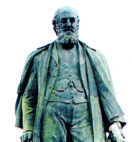
... This document proposes the creation of a documentary about George Lansell, known as the "Quartz King" of Bendigo, highlighting his significant impact on the region's goldfields and community. Suggests strong support for a film documenting George Lansell's life, backed by local council, historical society, and parliamentary representatives. ...This document proposes the creation of a documentary about George Lansell, known as the "Quartz King" of Bendigo, highlighting his significant impact on the region's goldfields and community. Suggests strong support for a film documenting George Lansell's life, backed by local council, historical society, and parliamentary representatives. ...This document proposes the creation of a documentary about George Lansell, known as the "Quartz King" of Bendigo, highlighting his significant impact on the region's goldfields and community. Suggests strong support for a film documenting George Lansell's life, backed by local council, historical society, and parliamentary representatives. Recommends submitting the idea to organizations like Film Australia. Lansell was a prominent mining magnate with private ownership of multiple mines and investments in Australia and abroad. He was known for his immense wealth, generosity, and contributions to Bendigo's prosperity. His mansion, Fortuna, was one of the most lavish in the colony. The Big 180 mine, owned by Lansell, was the deepest in the Southern Hemisphere by 1895 and yielded significant gold output. Lansell and his partners extracted an estimated three million pounds worth of gold from the Big 180. Lansell was celebrated for his philanthropy, supporting public institutions, charities, and miners in need. Upon his death in 1906, he left shares in his mines to employees and set up a trust fund for widows and orphans of Bendigo miners. The document emphasizes the rich historical material available for a documentary, drawing from local archives and historical accounts.Fortuna Article - "Long lives the king" Bendigo Miner 13 Sept 2007 by Max Thomson This item contains the following: 11217.32a Colour Photo of Mining Man Statue: the "Quartz King, Geoge Lansell 11217.32b Part of Page 10 - Article "Long lives the king"non-fictionbendigo, fortuna, george lansell, quartz king, big 180 mine -
 Bendigo Military Museum
Photograph - Defence Co-operation Project Students, School of Military Survey, Bonegilla, VIC, 1990
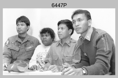
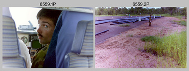
... Bendigo Military Museum 37 - 39 Pall Mall Bendigo goldfields This is a photograph of Defence Co-operation Project (DCP) students from the Pacific region who attended the 1/90 Specialist Carto course held at the School of Military Survey, Bonegilla, Victoria from the 9th of May to the 5th of June 1990. ...This is a photograph of Defence Co-operation Project (DCP) students from the Pacific region who attended the 1/90 Specialist Carto course held at the School of Military Survey, Bonegilla, Victoria from the 9th of May to the 5th of June 1990.This is a photograph of Defence Co-operation Project (DCP) students attending the 1/90 Specialist Carto course held at the School of Military Survey, Bonegilla, Victoria in 1990. The photograph was printed on photographic paper and is part of the Army Survey Regiment’s Collection. The photograph was scanned at 300 dpi. .1) - Photo, black & white, 1990, DCP Students L to R: SGT Ramos – Philippines, Miss Chukeni – Solomon Islands, SGT Laguador – Philippines, CPL Jais – Malaysia. .1P – Students, course title and date annotated on back of photo.royal australian survey corps, rasvy, army survey regiment, army svy regt, school of military survey, fortuna, asr -
 Bendigo Military Museum
Card - CARD, CHRISTMAS
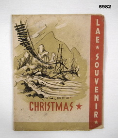
... Bendigo Military Museum 37 - 39 Pall Mall Bendigo goldfields Postcard/Christmas Card used by Servicemen to send home as a souvenir of the region. ...Postcard/Christmas Card used by Servicemen to send home as a souvenir of the region. Item relates back to Cat No 4316.4.Single sheet, fold up Christmas Card from the Island of Lae. Contains various random pictures of Island scenes. Predominately yellow in colour with red writing and red edges on one page. Pictures are all black and white and brown background. Other side is blank.Labelled on front "LAE, SOUVENIR" and "CHRISTMAS".souvenir, christmas card, lae -
 Bendigo Military Museum
Postcard - PHOTOGRAPHIC POSTCARDS WW1, C.WW1
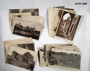
... goldfields Items in the collection relating to C.J.C. McQuie MM, refer Cat No 9680P for his service details. Postcard No's .10) - 15). These are from a Series that have printed text in Red at the top of the images. Postcards .16) - 38). These are from a major Series, all have at the top "Campagne DE 1914 - 1916" and cover bomb damage in many areas across the "Somme" region ...Items in the collection relating to C.J.C. McQuie MM, refer Cat No 9680P for his service details. Postcard No's .10) - 15). These are from a Series that have printed text in Red at the top of the images. Postcards .16) - 38). These are from a major Series, all have at the top "Campagne DE 1914 - 1916" and cover bomb damage in many areas across the "Somme" region..1) Postcard sepia tone of a Chalet in "Ostende". .2) Postcard sepia tone of a Church 1916 "Strazeele". .3) Postcard sepia tone, river scene in "Amiens". .4) - .5) One sepia, one B & W scenes in "Hazebrouck". .6) Postcard B & W, bomb damage "Albert". .7) Postcard B & W, bomb damage "Hazebrouck". .8) - .9) Postcard One B & W one sepia Bomb damage "Dunkerque" .10) - .11) Postcard B & W bomb damage around "Strazeele". .12) Postcard sepia tone, bomb damage "Strazeele". .13) Postcard B & W, bomb damage "Kemmel". .14) Postcard B & W, bomb damage "Merris". .15) Postcard B & W, bomb damage "Messines". .16) - .38) B & W series bomb damage various places. postcards, photos, mcquie -
 Bendigo Military Museum
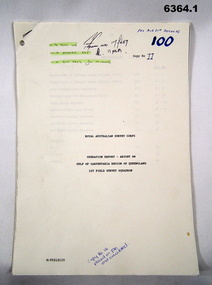
Administrative record - Royal Australian Survey Corps Report on Operation Aright 88 conducted by 1 Field Survey Squadron 1988, 1 Fd Svy Sqn, 9 Feb 1989
... Bendigo Military Museum 37 - 39 Pall Mall Bendigo goldfields Comprehensive Operation Report containing all aspects of OP Aright 88 in the Gulf of Carpentaria region of Queensland. ...Comprehensive Operation Report containing all aspects of OP Aright 88 in the Gulf of Carpentaria region of Queensland. Chapters include: General Information, Operations, Operational Support, Admin and Logistics, Communications, Conclusion and Recommendations. There are four Annexes, Area of Operations, Technical Summary, Nominal Roll, Det 1 Fd Svy Sqn and Air Support Contact Details.Unbound A4 Paper Report held together by a staple top LH corner. Typed pages and diagrams. 6364.1 is copy number 11, 6364.2 is copy number 12 6364.1 is copy number 11, "FOR AIR SURVEY RECORDS" "Tech WO", "Aero Trig", "ADJ", "SGT REES for Records" 6364.2 is copy number 12 "Placed on File and circulated", "Circular Received 15 Feb 1989" on back page. royal australian survey corps, rasvy, fortuna, army survey regiment, army svy regt, asr -
 Bendigo Military Museum
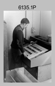
Photograph - Print Troop – Lithographic Squadron – Army Survey Regiment, Fortuna, Bendigo
... goldfields This collection of 23 photos was most likely taken in Lithographic Squadron, Army Survey Regiment, Fortuna, Bendigo, in 1988. In photos .1P and .2P the technician is preparing a Chromalin map proof for supporting information that would be printed on the reverse side of a topographic map. This map was commonly referred to as a ‘snack’ map, with photos of edible indigenous plants and descriptions endemic to that region ...This collection of 23 photos was most likely taken in Lithographic Squadron, Army Survey Regiment, Fortuna, Bendigo, in 1988. In photos .1P and .2P the technician is preparing a Chromalin map proof for supporting information that would be printed on the reverse side of a topographic map. This map was commonly referred to as a ‘snack’ map, with photos of edible indigenous plants and descriptions endemic to that region printed on the reverse side to assist soldiers living off the land in survival situations. The authoritative information was provided by Major Leslie James (Les) Hiddins aka ‘the Bush Tucker Man’ He is a retired Australian Army soldier and war veteran, who is best known for his love and knowledge of the Australian bush. See item 6190.6P for more information on the Chomalin proof production process. In the remaining photos, Print Troop’s technicians were most likely operating the Komoni, Planeta or Ultra-MAN-III offset printing presses, as well as working in the map despatch dock. Although these photos are not annotated most personnel are positively identified. This is a set of 23 photographs of Print Troop personnel and equipment from Lithographic Squadron at the Army Survey Regiment, Fortuna, Bendigo, 1988. The photographs were on 35mm negative film and were scanned at 96 dpi. They are part of the Army Survey Regiment’s Collection. .1) - Photo, black & white, 1988, Chromalin Proof laminating, Terry King. .2) - Photo, black & white, 1988, Chromalin Proof laminating, Terry King. .3) to .6) - Photo, black & white, 1988, Ultra-MAN-III Printing Press, Colin Yeats. .7) - Photo, black & white, 1988, Ultra-MAN-III Printing Press, L to R: Greg Rowe, SPR Mark ‘Dogs’ Doherty. .8) - Photo, black & white, 1988, Ultra-MAN-III Printing Press, SPR Mark ‘Dogs’ Doherty. .9) to .10) - Photo, black & white, 1988, Ultra-MAN-III Printing Press, John Bateman. .11) - Photo, black & white, 1988, Ultra-MAN-III Printing Press. .12) - Photo, black & white, 1988, Map laminator? L to R: SGT Dale Hudson, SGT Gary Kerr. .13) - Photo, black & white, 1988, Newkoni Komori Printing Press, Peter Hamilton. .14) to .17) - Photo, black & white, 1988, Original Heidelberg Printing Press, Peter Hamilton. .18) to .19) - Photo, black & white, 1988, Map Despatch area, SPR Steve Wright. .20) - Photo, black & white, 1988, Map Despatch area, L to R: unidentified, SGT Gary Kerr. .21) - Photo, black & white, 1988, Printing Presses - foreground: Ultra-MAN-III (x2), centre: Newkoni Komori and background: Planeta Polygraph. .22) - Photo, black & white, 1988, Ultra-MAN-III Printing Presses (x2). .23) - Photo, black & white, 1988, L to R: Daryl South, Mark McCulloch.No personnel are identifiedroyal australian survey corps, rasvy, army survey regiment, army svy regt, fortuna, asr, litho, printing -
 Bendigo Military Museum
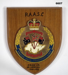
Plaque - PLAQUE, RAASC
... Bendigo Military Museum 37 - 39 Pall Mall Bendigo goldfields ANZUK was a Tripartite Force by Australia, New Zealand and UK to defend Pacific Region. ...ANZUK was a Tripartite Force by Australia, New Zealand and UK to defend Pacific Region. Started 1/11/71 to 31/12/74. Bases out of Singapore. This plaque represented the Base Transport Unit.Brown wooden shield with unit emblem mounted on it. Emblem round with unit name at bottom, Crown at top. Image of Singapore Island in Middle and flags of Australia, NZ and UK coming off island. Island is white, rest mainly gold colour and some navy blue and red on flags.Inscribed with "ANZUK FORCE SINGAPORE" & "ANZUK BASE TRANSPORT UNIT". Handwritten on shield at top " R.A.A.S.C." and at bottom "317633 CPL A. R. CORNELIUS 1970-1972". On back handwritten in texta "317633 CPL A. R. CORNELIUS ANZUK BTN Singapore 70-71-71." passchendaele barracks trust, anzuk -
 Bendigo Military Museum
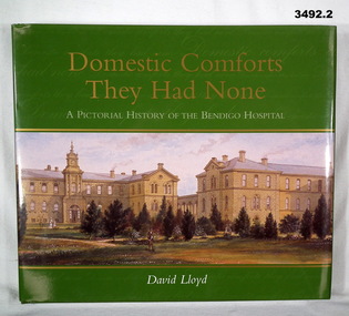
Book - BOOK, HOSPITAL, David Lloyd, Domestic Comforts They Had None, 2003
... Bendigo Military Museum 37 - 39 Pall Mall Bendigo goldfields From forward: A celebration of 150 years of making the people of Sandhurst, Bendigo, the Loddon Mallee Region, etc much healthier. books- military history Bendigo hospital A pictorial history of the Bendigo Hospital. .1) Hard cardboard cover with glossy finish. 232 pages, cut, plain, glossy white. ...From forward: A celebration of 150 years of making the people of Sandhurst, Bendigo, the Loddon Mallee Region, etc much healthier.A pictorial history of the Bendigo Hospital. .1) Hard cardboard cover with glossy finish. 232 pages, cut, plain, glossy white. Illustrated with black / white photos, illustrations & posters. .2) Dust cover with glossy finish. .1) & .2) Gold / white print on front & spine. Covers illustrated in colour of a view of the Bendigo Gold District Hospital - undated, probably 1880's. books- military history, bendigo, hospital -
 Bendigo Military Museum
Postcard - SOUVENIR POSTCARD, C. WW2
... Bendigo Military Museum 37 - 39 Pall Mall Bendigo goldfields The photo is in the region of “Berchtesgadener in Germany”, item was sent around Christmas 1945. ...The photo is in the region of “Berchtesgadener in Germany”, item was sent around Christmas 1945. Part of the collection re Frederick Gardner Davey DFC RAAF. Refer Cat No 3536P for his service records.Post card, rectangular shape, white edge around with a B & W photo of a building in a forested mountain region, in white on the bottom RH corner acknowledgement of the photographer, on the back is a hand written letter in blue ink and space for a stamp.On the rear in blue ink,” Wishing the recipient a happy Christmas and offering a description of the region where the photograph was taken, signed by Alan Fi”postcards, germany, souvenirs -
 Bendigo Military Museum
Map - MAP of IRAQ
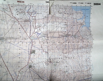
... Bendigo Military Museum 37 - 39 Pall Mall Bendigo goldfields Four topographical maps taped together of Tall Uwaynat and Tall Musa region of Iraq. ...Four topographical maps taped together of Tall Uwaynat and Tall Musa region of Iraq. Item belonging to Mathew Redwood. Refer Cat No 3891 for his service details.White paper, folded, four maps sticky taped togetherOrange fluoro marking out route taken by Australian forces in escort duties.maps, iraq -
 Bendigo Military Museum
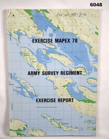
Administrative record - Army Survey Regiment - Exercise Mapex 78, Mar 1979
... goldfields Exercise Report on exercise Mapex 78. The exercise was designed to test the Army Survey Regiment in an intensive production phase of 30 days duration. Royal Australian Survey Corps RASvy Fortuna Army Survey Regiment Army Svy Regt ASR Top right hand corner of front cover "File on 788-2-14" A4 soft covered booklet, printed map of part of the Kimberley region of Western Australia on front and back covers, staple bound Army Survey Regiment - Exercise Mapex 78 Administrative record Army Survey Regiment - Exercise Mapex 78 Army Survey Regiment ...Exercise Report on exercise Mapex 78. The exercise was designed to test the Army Survey Regiment in an intensive production phase of 30 days duration.A4 soft covered booklet, printed map of part of the Kimberley region of Western Australia on front and back covers, staple boundTop right hand corner of front cover "File on 788-2-14"royal australian survey corps, rasvy, fortuna, army survey regiment, army svy regt, asr -
 Victoria Police Museum
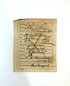
Crime Card, Crime Card Ballarat
... These crime cards are from Ballarat region, 1872. crime criminal record police victoria police goldfields ballarat crime card White paper card, stamped form, filled out in ink. ...Crime cards were used by police to record an offenders personal details, their offense, arrest and release or transfer. These crime cards are from Ballarat region, 1872. White paper card, stamped form, filled out in ink. crime, criminal record, police, victoria police, goldfields, ballarat, crime card -
 Bendigo Military Museum
Photograph - 4th Field Survey Squadron – Operation MIZMAZE 92, Kimberley region, Western Australia, 1992
... Bendigo Military Museum 37 - 39 Pall Mall Bendigo goldfields This is a set of 40 photographs taken in 1992 during 4th Field Survey Squadron’s deployment on Operation MIZMAZE 92 in the Kimberley region of Western Australia from the 13th of May to the 14th of July 1992. ...This is a set of 40 photographs taken in 1992 during 4th Field Survey Squadron’s deployment on Operation MIZMAZE 92 in the Kimberley region of Western Australia from the 13th of May to the 14th of July 1992. The area of operations was Wyndham, Halls Creek and Sandfire Flat. It was a two-part operation involving the field completion of topographic maps and the acquisition of mapping control by GPS field parties utilising Texas Instruments TI4100 Global Positioning System receivers. Survey parties conducted field checking of topographic maps and GPS control acquisition in Perentie 110 Series Survey variant FFR Land Rovers. Three Bell Kiowa LOH helicopters provided by 162 Recce Sqn supported field checking and limited deployment of GPS surveys parties. C-l30 Hercules from 36 Sqn supported deployment and extraction of personnel and equipment to and from from the AO. A Cessna 404 Titan Ambassador from Vee-H Aviation was used as the Wild RC10 camera platform for aerial photography acquisition.This is a set of 40 photographs taken in 1992 during 4th Field Survey Squadron’s deployment on Operation MIZMAZE 92 in the Kimberley region of Western Australia. The colour photographs are on 35mm negative film and are part of the Army Survey Regiment’s Collection. The photographs were scanned at 96 dpi. .1) - Photo, colour, 1992. CAPT Craig Hersant. .2) - Photo, colour, 1992. Unidentified officer/soldier. .3) & .4) - Photo, colour, 1992. Aboriginal rock art - Wandjina Gunduran, Donkey Creek. .5) - Photo, colour, 1992. Aboriginal rock art - Track Wandjinas, Donkey Creek. .6) & .7) - Photo, colour, 1992. CAPT Craig Hersant. .8) - Photo, colour, 1992. Kimberley region topography. CPL Glen Weatherell. .9) - Photo, colour, 1992. Unidentified personnel .10) - Photo, colour, 1992. Supermarket at unknown location. .11) to .13) - Photo, colour, 1992. Caravan park at unknown location. .14) - Photo, colour, 1992. Old bridge at Fitzroy Crosssing. .15) & .16) - Photo, colour, 1992. Survey party in Perentie 110 Series Land Rover. .17) & .18) - Photo, colour, 1992. Kimberley region topography. .19) - Photo, colour, 1992. Kimberley region topography. CPL Glen Weatherell. .20) - Photo, colour, 1992. Kimberley region topography, possibly the Bungle Bungles. .21) - Photo, colour, 1992. Kimberley region topography. SGT Frank Downie. .22) - Photo, colour, 1992. Kimberley region topography: the Bungle Bungles. .23) - Photo, colour, 1992. Kimberley region topography: the Bungle Bungles. .24) - Photo, colour, 1992. Kimberley region topography: the Bungle Bungles. SPR Neil Pedler. .25) & .26) - Photo, colour, 1992. Kimberley region topography: the Bungle Bungles. .27) - Photo, colour, 1992. Kimberley region topography. .28) - Photo, colour, 1992. Survey party with Perentie 110 Series Land Rover. .29) - Photo, colour, 1992. Kimberley region topography. .30) - Photo, colour, 1992. Survey party outside Perentie 110 Series Land Rover. .31) & .32) - Photo, colour, 1992. Survey party operating TI4100 GPS Receiver next to Perentie 110 Series Land Rover. SGT Eddie Jacobs. .33) & .34) - Photo, colour, 1992. Survey party operating TI4100 GPS Receiver next to Perentie 110 Series Land Rover. Unidentified surveyor. .35) - Photo, colour, 1992. Kimberley region topography. Hand water pump at well. .36) - Photo, colour, 1992. Survey party in Perentie 110 Series Land Rover. .37) - Photo, colour, 1992. Kimberley region topography. CPL Glen Weatherell. .38) - Photo, colour, 1992. Kimberley region topography viewed from Bell Kiowa LOH helicopter. .39) & .40) - Photo, colour, 1992. Unidentified surveyor field checking a preliminary map in a Bell Kiowa LOH helicopter..1P to .40P – There are no personnel identified. ‘1992 OP MIZMAZE annotated on negative sleeve.royal australian survey corps, rasvy, 4 fd svy sqn, op mizmaze 92