Showing 51 items matching "granite hill"
-
 Beaufort Historical Society
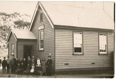
Photograph, Granite Hill School 2226 1914
... Granite Hill School 2226 1914...Granite Hill...Granite Hill School 1914 Teacher Miss Tait...Beaufort Historical Society 9 Livingstone st Beaufort 3373 Granite Hill School 1914 Teacher Miss Tait Granite Hill Granite Hill School Photograph Granite Hill School 2226 1914 Photograph Photograph ...Granite Hill School 1914 Teacher Miss TaitPhotographgranite hill, granite hill school -
 Beaufort Historical Society
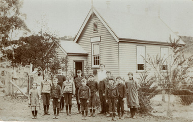
Photograph, Granite Hill School 1911
... Granite Hill School 1911...Granite Hill School...Beaufort Historical Society 9 Livingstone st Beaufort 3373 Granite Hill School Beaufort - History B&W Photograph Granite Hill School 1911 Photograph ...B&W Photographgranite hill school, beaufort - history -
 Bendigo Historical Society Inc.
Newspaper - Bendigo Advertiser Collection: Small Town With Big Hearts Article on Ravenswood, Nov 03 1993
... This item contains the following documents newspaper articles and black and white photos: 8091.605a Part of Page 30, the Bendigo Advertiser Weds Nov 03 1993 8091.605b Part of Page 30, the Bendigo Advertiser Wednesday Nov 03 1993 8091.605c Black and White Photo Man seated on the verandah of The Ravenswood homestead - Contact BHS for Details 8091.605d Black and White Photo of a house with the granite hill country behind - Contact BHS for Details 8091.605e Black and White Photo of the Ravenswood Homestead - Contact BHS for Details 8091.605f Black and White Photo of the Calder Highway at Ravenswood - Contact BHS for Details 8091.605g Black and White Photo of the Calder Highway sign at Ravenswood - Contact BHS for Details 8091.605h Black and White Photo of a Woman and a Man at the Junction Hotel at Ravenswood - Contact BHS for Details...This item contains the following documents newspaper articles and black and white photos: 8091.605a Part of Page 30, the Bendigo Advertiser Weds Nov 03 1993 8091.605b Part of Page 30, the Bendigo Advertiser Wednesday Nov 03 1993 8091.605c Black and White Photo Man seated on the verandah of The Ravenswood homestead - Contact BHS for Details 8091.605d Black and White Photo of a house with the granite hill country behind - Contact BHS for Details 8091.605e Black and White Photo of the Ravenswood Homestead - Contact BHS for Details 8091.605f Black and White Photo of the Calder Highway at Ravenswood - Contact BHS for Details 8091.605g Black and White Photo of the Calder Highway sign at Ravenswood - Contact BHS for Details 8091.605h Black and White Photo of a Woman and a Man at the Junction Hotel at Ravenswood - Contact BHS for Details Newspaper Bendigo Advertiser Collection: Small Town With Big Hearts Article on Ravenswood ...Ravenswood was intended to become a functioning town in the 19th century, with land subdivided into house lots, but this development never materialized. The area was originally part of the Alexander Number Two Run (later renamed Ravenswood Run), established in 1838 and covering 118,000 acres. Major Thomas Mitchell explored the area in 1837, naming its prominent features. The first discovery of gold in the Bendigo creek is credited to the wife of Ravenswood's overseer, Mr. Kennedy, in the early 1850s.This discovery contributed to the development of Bendigo and the surrounding region. The Ravenswood homestead was built in 1857 and is a significant Georgian-style building, more typical of Tasmania or eastern New South Wales.It features well-proportioned outbuildings, servants' quarters, and English-influenced gardens.The homestead currently sits on 400 acres of the original land, surrounded by a picturesque landscape of pastures, ancient gums, boulders, creeks, and gullies. For the past 20 years, the Beilharz family has owned and restored the homestead, transforming it into a serene and well-maintained property.The family's efforts have preserved both the building and its unique atmosphere.Community and ArchitectureUnlike other large homesteads in Victoria's Western District, Ravenswood Homestead was built for style and comfort, not as a working hub; work buildings like shearing sheds were located far from the main house. The homestead is physically and socially separated from the nearby township, lacking the close relationship often seen between English manor houses and their villages. Ravenswood Homestead stands as a historically significant site, notable for its architecture, landscape, and role in the early gold discoveries that shaped the Bendigo region. Ravenswood Pub (Junction Hotel) is located near the Calder Highway, the pub is a well-known spot for travellers and the motorcycle community. Recently rebuilt and managed by Stewart and Debbie Crowther, who previously worked in sales management in Bendigo. The Crowthers transformed the pub into a welcoming, family-oriented venue by removing restrictive rules for children and adding a play area and secure garden. Their approach was motivated by their own experience as parents and the needs of traveling families. The pub enjoys strong support from local residents, in addition to serving travellers. The nearest general store or milk bar is eight kilometers away, so the pub has tried to fill this gap by offering take-away food. The pub's freehold owner (an oil company) plans to build a petrol and convenience store next door, which would address the community's need for local services. There is no set timeline, but locals are optimistic about the positive impact. Ravenswood has lost several key amenities over the years, including its service station, railway station, school, and church. However, there is renewed growth, with new homes being built and anticipation that new businesses will help revitalize the area.Small Towns With Big Hearts Ravenswood. Series of photos and information about Ravenswood. Pictures by Peter Hyett. Written by Wayne Gregson. This item contains the following documents newspaper articles and black and white photos: 8091.605a Part of Page 30, the Bendigo Advertiser Weds Nov 03 1993 8091.605b Part of Page 30, the Bendigo Advertiser Wednesday Nov 03 1993 8091.605c Black and White Photo Man seated on the verandah of The Ravenswood homestead - Contact BHS for Details 8091.605d Black and White Photo of a house with the granite hill country behind - Contact BHS for Details 8091.605e Black and White Photo of the Ravenswood Homestead - Contact BHS for Details 8091.605f Black and White Photo of the Calder Highway at Ravenswood - Contact BHS for Details 8091.605g Black and White Photo of the Calder Highway sign at Ravenswood - Contact BHS for Details 8091.605h Black and White Photo of a Woman and a Man at the Junction Hotel at Ravenswood - Contact BHS for Detailsnewspaper, bendigo advertiser, ravenswood -
Federation University Historical Collection
Book, Northern Territory of South Australia Report Resulting from the Explorations by the Government Geologist, 1906, 1906
... It includes a chapter of Bathurst Island and Melville Island, Primitive Methhods of Chinese Mining, Early Days of Mining in the Northern Territory Images include sandbank at low tide, Douglas River, Granite at Union Hill, Night Cliff, East Point, union hill, zapopan gold mine Brook's Creek, Blow Gold Mine Yam Creek, Daly River Copper Mine, Mount Ellison Copper Mine, Point Charles Lighthouse, Blacks Camp near Point Charles Lighthouse, The Venture Stranded on a Daly River Sandbank, Hyland Bay Natives, Boabab Trees at Blunder Bay, The Wai Hoi, Mouth of Fitzmaurice River, Point Blaze Natives, Fort Hill and Old Gulnare Jetty Port Darwin, Large Anthill, Daly RIver Natives, Wargie Natives, L.C.E. ...It includes a chapter of Bathurst Island and Melville Island, Primitive Methhods of Chinese Mining, Early Days of Mining in the Northern Territory Images include sandbank at low tide, Douglas River, Granite at Union Hill, Night Cliff, East Point, union hill, zapopan gold mine Brook's Creek, Blow Gold Mine Yam Creek, Daly River Copper Mine, Mount Ellison Copper Mine, Point Charles Lighthouse, Blacks Camp near Point Charles Lighthouse, The Venture Stranded on a Daly River Sandbank, Hyland Bay Natives, Boabab Trees at Blunder Bay, The Wai Hoi, Mouth of Fitzmaurice River, Point Blaze Natives, Fort Hill and Old Gulnare Jetty Port Darwin, Large Anthill, Daly RIver Natives, Wargie Natives, L.C.E. ...Pale blue soft covered geological and general report. It includes a chapter of Bathurst Island and Melville Island, Primitive Methhods of Chinese Mining, Early Days of Mining in the Northern Territory Images include sandbank at low tide, Douglas River, Granite at Union Hill, Night Cliff, East Point, union hill, zapopan gold mine Brook's Creek, Blow Gold Mine Yam Creek, Daly River Copper Mine, Mount Ellison Copper Mine, Point Charles Lighthouse, Blacks Camp near Point Charles Lighthouse, The Venture Stranded on a Daly River Sandbank, Hyland Bay Natives, Boabab Trees at Blunder Bay, The Wai Hoi, Mouth of Fitzmaurice River, Point Blaze Natives, Fort Hill and Old Gulnare Jetty Port Darwin, Large Anthill, Daly RIver Natives, Wargie Natives, L.C.E. Gee, H.Y.L. Brown, H. Basedow. F.J. Williamson, Aboriginal crew (Pedro, Peter, Tobatchie, Bubs, Loman), Henry Roberts, Schollert's Grave It also includes a large folder Geological Map of the North-Western District Northern Territory of South Australia. northern territory of south australia, geology, l. o'loughlin, douglas river, bathurst island, melville island, apsley straight, chinese, aboriginal -
 Bendigo Historical Society Inc.
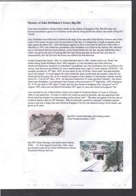
Document - MYSTERY OF JOHN MCMAHON'S GRAVE BIG HILL
... The Mystery of John McMahon's Grave, Big Hill mentions granite stone markers south of the Tunnel. ...History House 11 Mackenzie Street Bendigo goldfields PERSON Individual john mcmahon Mystery of John McMahon's Grave Big Hill John McMahon Big Hill Tunnel Mrs I Marchesi Mr Marchesi Mrs Ivy Irene Marchesi (nee Bone) Sarah McMahon Sarah McEwan (McKeown/McKeon) Ravenswood Station Kangaroo Flat Cemetery Sarah Jane McMahon Frederick Benton PictureAustralia Vic Rail Melbourne to Mount Alexander-Murray Rail Line Stone markers for John McMahon The Mystery of John McMahon's Grave, Big Hill mentions granite stone markers south of the Tunnel. ...The Mystery of John McMahon's Grave, Big Hill mentions granite stone markers south of the Tunnel. Some believed he was buried there, but further research has found he is buried at the Kangaroo Flat Cemetery in the Roman Catholic section, Grave No. 1134 on 20 May, 1874. Also mentioned is his widow was appointed Gate Keeper at Ravenswood on 2 September, 1874. Also mentioned is the death of Frederick Benton, who died on 24 February, 1860 of peritonitis. There is a sepia? Photo taken of the Big Hill Tunnel (Bendigo side looking south) from Picture Australia c. 1875 and a coloured one of the Big Hill Tunnel Bendigo side (photo taken March, 2008). On page 2 are two coloured views at Big Hill for John McMahon, 850 metres south of Big Hill Tunnel entrance, Melbourne side/east of line (photos taken March, 2008).person, individual, john mcmahon, mystery of john mcmahon's grave, big hill, john mcmahon, big hill tunnel, mrs i marchesi, mr marchesi, mrs ivy irene marchesi (nee bone), sarah mcmahon, sarah mcewan (mckeown/mckeon), ravenswood station, kangaroo flat cemetery, sarah jane mcmahon, frederick benton, pictureaustralia, vic rail, melbourne to mount alexander-murray rail line, stone markers for john mcmahon -
 Bendigo Historical Society Inc.
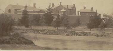
Photograph - BENDIGO GAOL, FROM COMMISSIONER'S GULLY, c.1880
... Another inclusion written in pencil states ' Bendigo Gaol about 1880. Granite from Big Hill was used to construct the cell blocks about 1860. ...Another inclusion written in pencil states ' Bendigo Gaol about 1880. Granite from Big Hill was used to construct the cell blocks about 1860. ...Sepia photograph of the Bendigo Gaol looking across from Barnard Street, Mining dam in foreground. . Conifers along Northern bank of creek with gaol buildings in the background. All buildings are of masonry. Inscriptions: '37' in red ballpoint ink top RH corner. On back of mount: stamped in circle 'Royal Historical Society of Victoria, Bendigo Branch' In blue ballpoint ink above circly '1959' In red ballpoint ink above circle '37'. In blue ballpoint ink in one corner '1880'. Inclusions in storage envelope: Bendigo Gaol, J Lerk, 28/02/2000. The Bendigo Gaol looking across Commissioner's Gully c1880. The grey granite cell blocks contrast with the red brick exterior walls. Photograph courtesy Bendigo Historical Sociery (No. 136, texta on back). Machine printed inclusion worded as above entry. Another inclusion written in pencil states ' Bendigo Gaol about 1880. Granite from Big Hill was used to construct the cell blocks about 1860. Prisioners did not have heating, beds, seats or eating utensils. A public meeting in 1862 called for the debtor's quarters at the gaol to be lit with gas, handsomely furnished throughout and that inmates be provided with a bottle of wine, one bottle of brandy daily and tobacco and pipes availabe at liberty. (from Butcher, 'Annals of Bendigo 1862, Vol. 1, 76B).buildings, government, watch house, sandhurst -
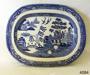 Flagstaff Hill Maritime Museum and Village
Ceramic - Serving Plate, Edward Challinor, Circa1862-1891
... Hill Maritime Museum and Village 89 Merri Street Warrnambool great-ocean-road The pottery was at Fenton, Stoke on Trent, Staffordshire UK and was established in 1825, by C J & GM Mason, they were succeeded by Mr. Samuel Boyle from whom the works passed into the hands of E & C Challinor, formally E Challinor & Co. Of Sandyford and Tunstall. The partners in Sandyford and Tunstall works are recorded as Edward Challinor Jnr and Charles Challinor Jnr and is presumably they are the sons of the partners of the Fenton pottery business. They produced china of white granite ...The pottery was at Fenton, Stoke on Trent, Staffordshire UK and was established in 1825, by C J & GM Mason, they were succeeded by Mr. Samuel Boyle from whom the works passed into the hands of E & C Challinor, formally E Challinor & Co. Of Sandyford and Tunstall. The partners in Sandyford and Tunstall works are recorded as Edward Challinor Jnr and Charles Challinor Jnr and is presumably they are the sons of the partners of the Fenton pottery business. They produced china of white granite, printed sponged common earthenware for the American, Australian, and other foreign and colonial markets. The main goods produced were tea, coffee, breakfast, dinner, and toilet ceramic sets as well as other earthenware goods. Their pottery marks were the Staffordshire rope knot with or without E & C Challinor or just E C. An early piece of earthenware pottery made in England for the Australian colonial market around the mid to late 19th century.Serving plate white body, smooth rim, and blue oriental designRope knot motif printed on back in blue with letters EC warrnambool, shipwrecked-coast, flagstaff-hill, flagstaff-hill-maritime-museum, shipwreck-coast, flagstaff-hill-maritime-village, earthenware, ceramic, willow pattern, serving plate, e & c challinor, potteries -
 Eltham District Historical Society Inc
Photograph - Digital Photograph, Alan King, St Matthew's Church and Hall, Panton Hill, 27 March 2008
... granite Eltham and towered Kangaroo Ground memorials illustrates the lack of affluence in the town and surrounding area. The grouping of church, school, store and post office is typical of country villages throughout Victoria. The Radiata Pine plantings are significant as an intact line of shelterbelt planting typical of the early 20th century. (Bick Study 1992) Covered under Heritage Overlay, Nillumbik Planning Scheme. Published: Nillumbik Now and Then / Marguerite Marshall 2008; photographs Alan King with Marguerite Marshall.; p63 Panton Hill’s...granite Eltham and towered Kangaroo Ground memorials illustrates the lack of affluence in the town and surrounding area. The grouping of church, school, store and post office is typical of country villages throughout Victoria. The Radiata Pine plantings are significant as an intact line of shelterbelt planting typical of the early 20th century. (Bick Study 1992) Covered under Heritage Overlay, Nillumbik Planning Scheme. Published: Nillumbik Now and Then / Marguerite Marshall 2008; photographs Alan King with Marguerite Marshall.; p63 Panton Hill’s ...St. Matthew's Church has historic significance as the town's church and physical and social focus for the community. The standard design buildings are good examples and important streetscape elements. The war memorial cross is the area's monument to the 20th century wars and its modest scale in comparison with the granite Eltham and towered Kangaroo Ground memorials illustrates the lack of affluence in the town and surrounding area. The grouping of church, school, store and post office is typical of country villages throughout Victoria. The Radiata Pine plantings are significant as an intact line of shelterbelt planting typical of the early 20th century. (Bick Study 1992) Covered under Heritage Overlay, Nillumbik Planning Scheme. Published: Nillumbik Now and Then / Marguerite Marshall 2008; photographs Alan King with Marguerite Marshall.; p63 Panton Hill’s first church services were held in a simple building made of paling timber, opposite the Hotel de France. The building was also used for Sunday School, a school and a hall.1 The St Matthew’s Church and hall at the corner of Church Road and Kangaroo Ground-St Andrews Road, were built in the early 20th century in the standard rectangular style of the times. The intact belt of Radiata Pines was common at that time. The war memorial concrete cross is the area’s monument for the 20th century wars. It is much more modest than those in Eltham, and particularly in Kangaroo Ground, demonstrating those townships’ comparative affluence.2 Early settler J Hughes, who donated the land to the Church of England, was the first to be married at St Matthews when he married Rachel Coutie. In later life he became a minister of religion.3 One much-liked preacher was George Hollow, who with his sister playing the harmonium, conducted church services at Panton Hill, St Andrews and Christmas Hills, for many years.This collection of almost 130 photos about places and people within the Shire of Nillumbik, an urban and rural municipality in Melbourne's north, contributes to an understanding of the history of the Shire. Published in 2008 immediately prior to the Black Saturday bushfires of February 7, 2009, it documents sites that were impacted, and in some cases destroyed by the fires. It includes photographs taken especially for the publication, creating a unique time capsule representing the Shire in the early 21st century. It remains the most recent comprehenesive publication devoted to the Shire's history connecting local residents to the past. nillumbik now and then (marshall-king) collection, panton hill, st matthew's church, panton hill war memorial -
 The Beechworth Burke Museum
Geological specimen - Feldspathic Sandstone
... granitic-type, primary crystalline, rocks. If the sandstone is dominantly plagioclase, then it is igneous in origin Sandstone features prominently in public buildings throughout Victoria. Most of the sandstone used as dimension stone in the State came from three sources: the Heatherlie quarry in the Grampians (Silurian), the Bacchus Marsh area (Permian), and the Barrabool Hills near Geelong (Cretaceous)....granitic-type, primary crystalline, rocks. If the sandstone is dominantly plagioclase, then it is igneous in origin Sandstone features prominently in public buildings throughout Victoria. Most of the sandstone used as dimension stone in the State came from three sources: the Heatherlie quarry in the Grampians (Silurian), the Bacchus Marsh area (Permian), and the Barrabool Hills near Geelong (Cretaceous). ...Feldspathic arenites are sandstones that contain less than 90% quartz, and more feldspar than unstable lithic fragments, and minor accessory minerals.Feldspathic sandstones are commonly immature or sub-mature.These sandstones occur in association with cratonic or stable shelf settings. Feldspathic sandstones are derived from granitic-type, primary crystalline, rocks. If the sandstone is dominantly plagioclase, then it is igneous in origin Sandstone features prominently in public buildings throughout Victoria. Most of the sandstone used as dimension stone in the State came from three sources: the Heatherlie quarry in the Grampians (Silurian), the Bacchus Marsh area (Permian), and the Barrabool Hills near Geelong (Cretaceous).Sandstone features prominently in public buildings throughout Victoria, making this specimen special as it shows the materials used by Victorian building companies. Sandstone can also be crushed, crushed stone is used in the construction of roadways and road structures such as bridges, and in buildings, both commercial and residential. This specimen is part of a larger collection of geological and mineral specimens collected from around Australia (and some parts of the world) and donated to the Burke Museum between 1868-1880. A large percentage of these specimens were collected in Victoria as part of the Geological Survey of Victoria that begun in 1852 (in response to the Gold Rush) to study and map the geology of Victoria. Collecting geological specimens was an important part of mapping and understanding the scientific makeup of the earth. Many of these specimens were sent to research and collecting organisations across Australia, including the Burke Museum, to educate and encourage further study. A feldspar-rich sandstone, a sandstone intermediate in composition between an arkosic sandstone and a quartz sandstone, containing 10% to 25% feldspar and less than 20% matrix material of clay, sericite, and chlorite. Feldspathic arenite containing less than 90 percent of the composition of quartz. Feldspar is the main composition. Feldspathic arenite may contain fragments of unstable rock, and a little amount of other minerals such as mica and heavy minerals. Some feldspathic arenite have pink or red color because of the presence of potassium feldspar or iron oxide. There are also colored light gray to white. These sandstones are usually medium to coarse grained and can contain a high percentage of granules with angular until subangular roundness. The content of the matrix can appear as the rest up to more than 15 percent, and sorting of grains can present as moderate to poorly sorted. Feldspathic sandstones are generally immature in textural maturity. Feldspathic arenite can not be judged from the structure of the sediment. Bedding can emerge from the laminate parallel to the crossbed. Fossils may appear in the layer deposited on the sea. Feldspathic arenites usually appear on the craton or the continental shelf, which can be associated with conglomerate, quartz lithic arenite, carbonate rock, or evaporites. This sandstone may also appear on the succession of sedimentary basins deposited on an unstable or deep sea, and moving arc setting. According to Pettijohn (1963) Arkose make up about 15 percent of all sandstones. Some Arkose formed in situ when the granite and related rocks disintegrate and generate granular sediments. Most of the material feldspathic sandstones derived from primary crystalline granitic rocks, such as granite or metasomatic rocks containing abundant potassium feldspar. Mineral contained in sandstones is mostly a form of plagioclase feldspar derived from quartz diorite or volcanic rock. Feldspar contained on this sandstone comes from arid to cool climates when the chemical weathering process is reduced.sandstone, natural stone, feldspathic sandstone, burke museum, geology, geological, geological specimen -
 The Beechworth Burke Museum
Photograph, 1857
... Enriched with gold washed out of the surrounding granite, these alluvial deposits achieved fame from 1852 onwards as the Spring Creek Diggings sprang to life (not realised as geographically important until 1871). In Spring Creek that runs behind the main street of Beechworth, near the foot of Newtown Hill a pint pot of gold was discovered on one of these expeditions in 1852 by prospectors Baker and Strickland and the gold rush town of Spring Creek was formed. ...Enriched with gold washed out of the surrounding granite, these alluvial deposits achieved fame from 1852 onwards as the Spring Creek Diggings sprang to life (not realised as geographically important until 1871). In Spring Creek that runs behind the main street of Beechworth, near the foot of Newtown Hill a pint pot of gold was discovered on one of these expeditions in 1852 by prospectors Baker and Strickland and the gold rush town of Spring Creek was formed. ...This photograph is of old mine workings on the site of the Spring Creek diggings. Spring Creek is a contact zone for granite pluton and siltstones, shales and standstones; which has, over time, encouraged natural springs to form. Enriched with gold washed out of the surrounding granite, these alluvial deposits achieved fame from 1852 onwards as the Spring Creek Diggings sprang to life (not realised as geographically important until 1871). In Spring Creek that runs behind the main street of Beechworth, near the foot of Newtown Hill a pint pot of gold was discovered on one of these expeditions in 1852 by prospectors Baker and Strickland and the gold rush town of Spring Creek was formed. Australian gold rushes have always created a sense of independence and freedom; as do-it-yourself, off-grid, low-tech adventures. People of all backgrounds were drawn to the gold fields by the prospect of riches and adventure, but they also learned self-sufficiency and found freedom of expression. Industry boomed, new practices were adopted and social norms were upended. This image is of historical significance as it informs on the history of Australian gold mining. It represents the innovation that accompanied the mining industry and the importance of gold mining in town building and regional histories. Black and white rectangular photograph on unmounted board.gold mining, spring creek, mining, geography, geology -
 The Beechworth Burke Museum
Photograph, Bayless C. - Manager, 1875
... Hills Hospital was constructed between 1864 and 1867, with buildings created in a number of periods. It formally opened on 24 October 1867 and, along with the Ovens Hospital and the Benevolent Asylum, made Beechworth a prominent social welfare centre in Victoria. Large masses of granite...Hills Hospital was constructed between 1864 and 1867, with buildings created in a number of periods. It formally opened on 24 October 1867 and, along with the Ovens Hospital and the Benevolent Asylum, made Beechworth a prominent social welfare centre in Victoria. Large masses of granite ...In this photo, taken in around 1875, is depicted the exterior of the Beechworth Mental Asylum buildings, with the administration buildings far right of the photo. A sunken boundary wall in the foreground and some people in view, sitting at the pavillion in the centre of the image. The two-storey buildings, designed in Italianate style, and the three-storey towers at the front, influenced by the asylum at Colney Hatch in England. The architecture of the buildings shares key features with other contemporary institutions, like Aradale at Ararat, and its design is attributed to the Public Works Department architect, J.J. Clark, whose name is connected with the construction of many other important public buildings, such as the Asylums at Kew and Ararat, the front block of the Royal Mint, Melbourne and the Melbourne Customs House. The Mayday Hills Hospital was constructed between 1864 and 1867, with buildings created in a number of periods. It formally opened on 24 October 1867 and, along with the Ovens Hospital and the Benevolent Asylum, made Beechworth a prominent social welfare centre in Victoria. Large masses of granite were excavated for its foundation and around 250 workmen were employed for its construction. The building, divided into six sections, was comprised of dormitories, doctors` rooms and plenty ancillary rooms and facilities, such as laundries, reading rooms, a concert hall and cooking areas. The site was chosen for its panoramic view of the countryside, the hilltop atmosphere and the native fauna, all contributing to the cure of patients. The Hospital was originally named the “Ovens Lunatic Asylum” but during the centenary celebrations in 1967 the name was officially changed to “Mayday Hills Hospital”, showing the gradual shift in the perception and understanding of mental health conditions over the last decades. The Hospital lies on the traditional land of the Kulin Nation.This photograph is historically significant as it provides an insight into the location, surroundings and the exterior of the Mayday Hills Hospital at the end of the 19th century. It also contributes to the understanding of the district`s development and its importance to the course of Victoria`s history and is acknowledged as a unique construction, being one of three identified as the largest of their kind.Black and white rectangular photograph printed on matte photographic paper mounted on board.Reverse: 37/ 3443/ Beechworth Asylum about 1875/ American & Australasian/Photographic Company/Victoria Branch./C.Bayless, Manager./ No./beechworth mental asylum, aradale, public works department, j.j. clark, melbourne customs house, colney hatch, italianate style, mayday hills hospital, royal mint, granite, benevolent asylum, dormitories, ovens lunatic asylum, ancillary rooms, centenary celebrations, three-storey towers, countryside, mental health conditions, kulin nation, concert hall -
 The Beechworth Burke Museum
Photograph - Photograph Reproduction, 1998
... granite were excavated for its foundation and around 250 workmen were employed for its construction. The building, divided into six sections, was comprised of dormitories, doctors` rooms and plenty ancillary rooms and facilities, such as laundries, reading rooms, a concert hall and cooking areas. The site was chosen for its panoramic view of the countryside, the hilltop atmosphere and the native fauna, all contributing to the cure of patients. The Hospital was originally named the “Ovens Lunatic Asylum” but, during the centenary celebrations in 1967, the name was officially changed to “Mayday Hills...Mental Hospital Beechworth fern house female nurses Nurses` Home Nurses` Training School nurses` hostel Mayday Hills Hospital Ovens Hospital Colney Hatch two-storey buildings Italianate style Benevolent Asylum Ovens Lunatic Asylum Kulin Nation workmen covered walkway granite hilltop atmosphere mental health Reverse: 3445/ Black and white rectangular photograph printed on paper unframed. ...The photograph, created in 1998, is a copy of the original one, depicting a nurse in uniform at the Mental Hospital in Beechworth, with a fern house behind her. In the background, the two-storey building is in view, along with the covered walkway. The institution had to operate with serious shortage of female nurses for long periods of time. During the 1880s, small houses (cottages) were built to offer accommodation for the nurses living in the hospital and in 1937 began the construction of a nurses` hostel. In 1962 the upper level of the Nurses` Home was converted into a Nurses` Training School. The Mayday Hills Hospital was constructed between 1864 and 1867, with buildings created in a number of periods. It formally opened on 24 October 1867 and, along with the Ovens Hospital and the Benevolent Asylum, made Beechworth a prominent social welfare centre in Victoria. The need for an institution of this kind was arisen due to the increased number of people with mental disturbances (induced by the harsh living conditions on the goldfields) and the remoteness of the district from Melbourne. The two-storey buildings, designed in Italianate style, and the three-storey towers at the front, were influenced by the asylum at Colney Hatch in England. Large masses of granite were excavated for its foundation and around 250 workmen were employed for its construction. The building, divided into six sections, was comprised of dormitories, doctors` rooms and plenty ancillary rooms and facilities, such as laundries, reading rooms, a concert hall and cooking areas. The site was chosen for its panoramic view of the countryside, the hilltop atmosphere and the native fauna, all contributing to the cure of patients. The Hospital was originally named the “Ovens Lunatic Asylum” but, during the centenary celebrations in 1967, the name was officially changed to “Mayday Hills Hospital”, showing the gradual shift in the perception and understanding of mental health conditions over the last decades. The Hospital lies on the traditional land of the Kulin Nation.This photograph is historically significant as it provides an insight into the everyday life of staff living within the walls of the Mayday Hills Hospital. It also offers important information about the location and the exterior of the Hospital and contributes to the understanding of the district`s development and its importance to the course of Victoria`s history.Black and white rectangular photograph printed on paper unframed.Reverse: 3445/mental hospital, beechworth, fern house, female nurses, nurses` home, nurses` training school, nurses` hostel, mayday hills hospital, ovens hospital, colney hatch, two-storey buildings, italianate style, benevolent asylum, ovens lunatic asylum, kulin nation, workmen, covered walkway, granite, hilltop atmosphere, mental health -
 Phillip Island and District Historical Society Inc.
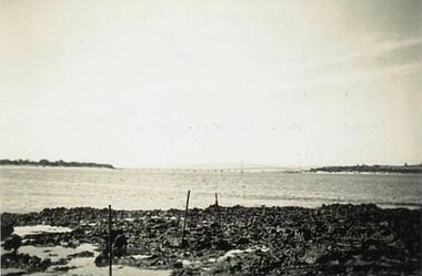
Photographs, 1948
... 221-01 Photograph of Suspension Bridge taken from Quarry area with Bass Hills in the background. 221-02 Copy of a Postcard of the Phillip Island Granite Quarry at Cape Woolamai. ...Phillip Island and District Historical Society Inc. phillip-island-and-the-bass-coast Four photographs donated by Jim Osterlund granite quarry cape woolamai phillip island suspension bridge w kennon jetty cape woolamai c richardson cape woolamai beacon jim osterlund 221-01 Photograph of Suspension Bridge taken from Quarry area with Bass Hills in the background. 221-02 Copy of a Postcard of the Phillip Island Granite Quarry at Cape Woolamai. ...Four photographs donated by Jim Osterlund221-01 Photograph of Suspension Bridge taken from Quarry area with Bass Hills in the background. 221-02 Copy of a Postcard of the Phillip Island Granite Quarry at Cape Woolamai. Rocks in the foreground and jetty with crane on the right. An F & J Postcard. 221-03 Photograph of W Kennon's Jetty at Cape Woolamai with large rocks on the beach in the foreground. 221-04 Photograph of Mr C Richardson standing in front of a beacon at Cape Woolamai.granite quarry cape woolamai, phillip island suspension bridge, w kennon jetty cape woolamai, c richardson, cape woolamai beacon, jim osterlund -
 Eltham District Historical Society Inc
Negative - Photograph, Unveiling of War Memorial Obelisk, corner of Main Road and Bridge Street, Eltham
... "Beneath a lonely pine tree on the hill crest out from Eltham, where the Greensborough Road junctions with the main Melbourne Road, Eltham has erected an everlasting tribute to the memory of the fallen heroes of the district. It is an obelisk of Harcourt granite..."Beneath a lonely pine tree on the hill crest out from Eltham, where the Greensborough Road junctions with the main Melbourne Road, Eltham has erected an everlasting tribute to the memory of the fallen heroes of the district. It is an obelisk of Harcourt granite ...The unveiling of the Eltham Obelisk War Memorial was performed by the Rev. Padre Charles Tregear, assisted by Church of England vicar, Mr Safsford on August 3, 1919. Reproduced page 99 of "Pioneers & Painters." "Beneath a lonely pine tree on the hill crest out from Eltham, where the Greensborough Road junctions with the main Melbourne Road, Eltham has erected an everlasting tribute to the memory of the fallen heroes of the district. It is an obelisk of Harcourt granite in the rough, bearing an appropriate inscription and 27 names—an unpretentious monument by the wayside, which will stand for all time silently expressing the appreciation of the living for the sacrifice of the dead. The obelisk stands 14 feet high. ... Representatives of every house in the town, and many people from the surrounding district, gathered around the obelisk for the opening ceremony. The spring-like sunshine of the afternoon attracted everybody out of doors. There must have been 700 people present when the Lieutenant-Governor, Sir William Irvine, removed the draping of flags and revealed the names on the obelisk, the base of which was surrounded by wreaths and branches of wattle bloom, placed there by parents whose sorrow at the loss of sons was blunted, for the day at least, by feelings of pride. .." Age, Monday 4 August 1919, page 8 This was the memorial's orginal location. It has been relocated numerous times.This photo forms part of a collection of photographs gathered by the Shire of Eltham for their centenary project book,"Pioneers and Painters: 100 years of the Shire of Eltham" by Alan Marshall (1971). The collection of over 500 images is held in partnership between Eltham District Historical Society and Yarra Plenty Regional Library (Eltham Library) and is now formally known as the 'The Shire of Eltham Pioneers Photograph Collection.' It is significant in being the first community sourced collection representing the places and people of the Shire's first one hundred years.Digital image 4 x 5 inch B&W Negsepp, shire of eltham pioneers photograph collection, eltham, main road, bridge street, eltham war memorial, obelisk, obelisk corner -
 Eltham District Historical Society Inc
Negative - Photograph, Unveiling of War Memorial Obelisk, corner of Main Road and Bridge Street, Eltham, 3 Aug. 1919
... "Beneath a lonely pine tree on the hill crest out from Eltham, where the Greensborough Road junctions with the main Melbourne Road, Eltham has erected an everlasting tribute to the memory of the fallen heroes of the district. It is an obelisk of Harcourt granite..."Beneath a lonely pine tree on the hill crest out from Eltham, where the Greensborough Road junctions with the main Melbourne Road, Eltham has erected an everlasting tribute to the memory of the fallen heroes of the district. It is an obelisk of Harcourt granite ...The unveiling of the Eltham Obelisk War Memorial was performed by the Rev. Padre Charles Tregear, assisted by Church of England vicar, Mr Safsford on August 3, 1919. Reproduced page 99 of "Pioneers & Painters." "Beneath a lonely pine tree on the hill crest out from Eltham, where the Greensborough Road junctions with the main Melbourne Road, Eltham has erected an everlasting tribute to the memory of the fallen heroes of the district. It is an obelisk of Harcourt granite in the rough, bearing an appropriate inscription and 27 names—an unpretentious monument by the wayside, which will stand for all time silently expressing the appreciation of the living for the sacrifice of the dead. The obelisk stands 14 feet high. ... Representatives of every house in the town, and many people from the surrounding district, gathered around the obelisk for the opening ceremony. The spring-like sunshine of the afternoon attracted everybody out of doors. There must have been 700 people present when the Lieutenant-Governor, Sir William Irvine, removed the draping of flags and revealed the names on the obelisk, the base of which was surrounded by wreaths and branches of wattle bloom, placed there by parents whose sorrow at the loss of sons was blunted, for the day at least, by feelings of pride. .." Age, Monday 4 August 1919, page 8 This was the memorial's orginal location. It has been relocated numerous times.This photo forms part of a collection of photographs gathered by the Shire of Eltham for their centenary project book,"Pioneers and Painters: 100 years of the Shire of Eltham" by Alan Marshall (1971). The collection of over 500 images is held in partnership between Eltham District Historical Society and Yarra Plenty Regional Library (Eltham Library) and is now formally known as the 'The Shire of Eltham Pioneers Photograph Collection.' It is significant in being the first community sourced collection representing the places and people of the Shire's first one hundred years.Digital image 4 x 5 inch B&W Neg Print 9 x 12.5cmsepp, shire of eltham pioneers photograph collection, eltham, main road, eltham war memorial, bridge street, obelisk, obelisk corner -
 Eltham District Historical Society Inc
Photograph, St Andrews Primary School, Eltham Heritage Tour, 24 May 1992, 24/05/1992
... Hill the soil was not rich and supported only scarce growth. Perfunctory prospecting and mining had taken place in this area, though not with the diligence applied at Research. Again we saw the ingredients of a settlement, this one organised by Government, the Hotel, the Store, the School. Down from Memorial Park the School grounds had original tree planting and the School Bell dedicated to Maud Rattray who died in 1922. There is a new Hall and opposite in the grounds of the Church and Sunday School a modest Memorial Cross of granite...Hill the soil was not rich and supported only scarce growth. Perfunctory prospecting and mining had taken place in this area, though not with the diligence applied at Research. Again we saw the ingredients of a settlement, this one organised by Government, the Hotel, the Store, the School. Down from Memorial Park the School grounds had original tree planting and the School Bell dedicated to Maud Rattray who died in 1922. There is a new Hall and opposite in the grounds of the Church and Sunday School a modest Memorial Cross of granite ...ELTHAM HERITAGE TOUR The Society excursion on 24th May 1992 was arranged by David Bick, leader of the team carrying out the Shire's heritage study. David selected a number of sites or buildings identified in the study, some of them lesser known components of the Shire's heritage. The tour commenced at the Eltham Shire Office at 10.00 am. Travel was by private car and mini-bus with stops at about twelve locations for commentary by David.It included a short walk in Hurstbridge and lunch at Kinglake. Highlights of the tour included: - 10 am Leave from Shire Offices - 3 Important Trees - A Physical Link to Eltham's First Settlers - Toorak Mansion Gates - A Surviving Farm House - An Intact Circa 1900 Main Street - First Settlers - Gold Miners, and Timber-getters - An Early Hotel - A Pioneering Homestead - Changing Eltham Shire - 20th Century - 4 pm Afternoon Tea and Finish Tour Extract from ELTHAM CULTURAL HERITAGE TOUR (Newsletter No. 85, July 1992, by Bettina Woodburn) "At St Andrews we noted the old and new schools, the Anglican Church, the Hall, the Bakery and the pub – still a popular watering and eating place. Climbing towards Panton Hill the soil was not rich and supported only scarce growth. Perfunctory prospecting and mining had taken place in this area, though not with the diligence applied at Research. Again we saw the ingredients of a settlement, this one organised by Government, the Hotel, the Store, the School. Down from Memorial Park the School grounds had original tree planting and the School Bell dedicated to Maud Rattray who died in 1922. There is a new Hall and opposite in the grounds of the Church and Sunday School a modest Memorial Cross of granite with inscriptions and in memory of four 'fallen comrades'. This small section of the main road retained the small village atmosphere; although the population had increased there had been little alteration."Record of the Society's history and activities and highlighting various aspects of the Heritage Study undertaken by David Bick used to create the future heritage overlay for the Shire of Eltham and later Nillumbik Shire.Roll of 35mm colour negative film, 4 stripsKodak Gold 100 5095shire of eltham historical society, activities, heritage tour, st andrews -
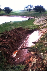 Bendigo Historical Society Inc.
Slide - Dunn's Rock Eppalock, 2012
... Hills Gravel are also found in the area. Another unique geological feature of this area is the Permian Glacial Pavement rocks north and south of Eppalock and glacial sediments (such as “Dunn’s Rock” and “Kellams Rock”). During the ice age (up to 280 million years ago) large glaciers moving over the countryside, scoured out sediments, pulverized bedrock, polished and cut grooves into bedrock in the direction of ice movement. When the ice melted boulders etc where left behind in areas of entirely different rock types, such as a 100 Tonne granite...Hills Gravel are also found in the area. Another unique geological feature of this area is the Permian Glacial Pavement rocks north and south of Eppalock and glacial sediments (such as “Dunn’s Rock” and “Kellams Rock”). During the ice age (up to 280 million years ago) large glaciers moving over the countryside, scoured out sediments, pulverized bedrock, polished and cut grooves into bedrock in the direction of ice movement. When the ice melted boulders etc where left behind in areas of entirely different rock types, such as a 100 Tonne granite ...The low rolling hills of the Kimbolton countryside consist of ancient, hard and fractured Ordovician rock up to 65 million years old, which was originally deposited deep under the sea. Rocks mainly are sandstone, mudstone, black shale and quartz conglomerates. Marine fossils can be found in the area. Around seven million years ago a basalt flow buried the original bedrock along the along the Campaspe River. Ongoing weathering, wind and water movement over the following years has produced younger clay, sand, silt and gravel deposits throughout the area. Patches of White Hills Gravel are also found in the area. Another unique geological feature of this area is the Permian Glacial Pavement rocks north and south of Eppalock and glacial sediments (such as “Dunn’s Rock” and “Kellams Rock”). During the ice age (up to 280 million years ago) large glaciers moving over the countryside, scoured out sediments, pulverized bedrock, polished and cut grooves into bedrock in the direction of ice movement. When the ice melted boulders etc where left behind in areas of entirely different rock types, such as a 100 Tonne granite block known as ‘The Stranger’ near Derrinal. Dunn's Rock (Glaciated Pavement) Eppalock - Photos of the rock and a field group collecting date with Lake Eppalock (Knowsley) in the backgroundhistory, bendigo, dunn's rock eppalock, kimbolton forest, lake eppalock, gately collection -
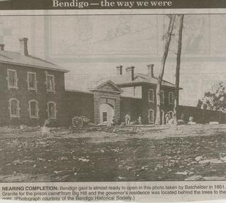 Bendigo Historical Society Inc.
Newspaper - JENNY FOLEY COLLECTION: NEARING COMPLETION
... Bendigo goal is almost ready to open in this photo taken by Batchelder in 1861, Granite for the prison came from Big Hill and the governor's residence was located behind the trees to the right. ...Bendigo goal is almost ready to open in this photo taken by Batchelder in 1861, Granite for the prison came from Big Hill and the governor's residence was located behind the trees to the right. ...BHS CollectionBendigo Advertiser ''The way we were'' from 2000. Bendigo goal is almost ready to open in this photo taken by Batchelder in 1861, Granite for the prison came from Big Hill and the governor's residence was located behind the trees to the right. (Photograph courtesy of the Bendigo Historical Society). The clip is in a folder.newspaper, bendigo advertiser, the way we were -
 Bendigo Historical Society Inc.
Document - ARTICLE: BENDIGO MONUMENT AND HORSE TROUGHS (''FEW LEFT'')
... granite crowned with five lamps and four drinking fountains at the base along with four horse troughs - at the intersection of Bridge St and Pall Mall. (site of present Gold Pioneers statue). Column moved to corner of Williamson and Lyttleton Terrace,initially with troughs and fountain. Position of four troughs is given by author but this has been crossed out subsequently with the note that the troughs are at the Botanical Gardens, White Hills...Hills Vahland William Beebe. Handwritten 2-paged article about a monumental column and horse trough's (''Few Left'') - no author. Originally a 20 foot column of Harcourt granite ...Handwritten 2-paged article about a monumental column and horse trough's (''Few Left'') - no author. Originally a 20 foot column of Harcourt granite crowned with five lamps and four drinking fountains at the base along with four horse troughs - at the intersection of Bridge St and Pall Mall. (site of present Gold Pioneers statue). Column moved to corner of Williamson and Lyttleton Terrace,initially with troughs and fountain. Position of four troughs is given by author but this has been crossed out subsequently with the note that the troughs are at the Botanical Gardens, White Hills. Probably Vahland designed fountain, William Beebe stonemason.bendigo, history, city history, monumental column, horse troughs, bridge street, pall mall, botanical gardens white hills, vahland, william beebe. -
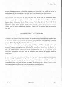 Bendigo Historical Society Inc.
Document - MINING IN BENDIGO COLLECTION: UNEARTHED QUARTZ CRUSHER
... Some years ago, a solid granite stone-crusher was seen at Diamond Hill. It was at the site of the old Diamond Hill Hotel. ...Some years ago, a solid granite stone-crusher was seen at Diamond Hill. It was at the site of the old Diamond Hill Hotel. ...Typed notes mentioning the early pioneers of Bendigo Gold Mining. Some of them are: Messrs Ballerstedt, Wittschiebe, Luffsman, Roeder Lazarus, Kock, Hildebrandt, Bruhn,Miller, Annear, Wells, Rae,Jackson, Woodward, Sterry, Burrowes, Thorp, Heine, Holmes, Gould, Allen, Brooks, Watson and Geo Lansell. In 1911 a quartz crusher was unearthed in McCrae Street during excavations at the site of the new St.Kilian's Girls Club Rooms. It was used by the late Mr. James Irons. It was found at a depth of ten feet. Mr. Angus Kennedy, who believed that he manufactured the plant for Mr. Irons, said Mr. Irons used to crush very rich quartz from the Sheepshead Reef, south of the Big Blue Battery. Some years ago, a solid granite stone-crusher was seen at Diamond Hill. It was at the site of the old Diamond Hill Hotel. The Comet Reef was found by Mr. Driesslau, who found gold in an outcrop when he was shooting parrots. Also mentioned is the tunnel that goes right through Diamond Hill.document, gold, mining in bendigo, mining in bendigo, unearthed quartz crusher, messrs ballerstedt, wittschiebe, luffsman, roeder lazarus, kock, hildebrandt, bruhn, miller, annear, wells, rae, jackson, woodward, sterry, burrowes, thorp, heine, holmes, gould, allen, brooks, watson, geo lansell, bendigo advertiser april 28th 1911, st kilian's girls' club rooms, mr james irons, mr angus kennedy, sheepshead reef, big blue battery, diamond hill hotel, victoria proprietary ltd., comet reef, mr driesslau, diamond hill tunnel -
 Flagstaff Hill Maritime Museum and Village
Photograph
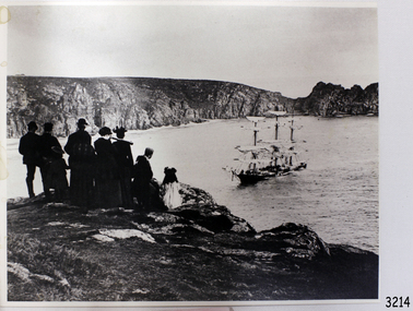
... flagstaff-hill-maritime-village...photograph...granite...Flagstaff Hill Maritime Museum and Village 89 Merri Street Warrnambool great-ocean-road flagstaff hill warrnambool shipwrecked-coast flagstaff-hill flagstaff-hill-maritime-museum maritime-museum shipwreck-coast flagstaff-hill-maritime-village photograph granite state Black and White Photograph sailing ship Granite State -with people watching in foreground. 253 mm x 202 mm. ...Black and White Photograph sailing ship Granite State -with people watching in foreground. 253 mm x 202 mm. SH 105 Ships F - H.flagstaff hill, warrnambool, shipwrecked-coast, flagstaff-hill, flagstaff-hill-maritime-museum, maritime-museum, shipwreck-coast, flagstaff-hill-maritime-village, photograph, granite state -
 Flagstaff Hill Maritime Museum and Village
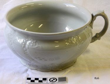
Ceramic - Chamber Pot, 1912
... Flagstaff Hill Maritime Museum and Village 89 Merri Street Warrnambool great-ocean-road In the 19th and early 20th centuries, J. & G. Meakin were important, large-scale producers of good quality, ironstone tableware (‘White Granite’ ware) that met a ready market in the United States, South America, Australia, and other traditional British markets. ...In the 19th and early 20th centuries, J. & G. Meakin were important, large-scale producers of good quality, ironstone tableware (‘White Granite’ ware) that met a ready market in the United States, South America, Australia, and other traditional British markets. By the 1890s the company was one of the world’s largest earthenware manufacturers. Although export teaware and tableware was the factory’s staple commodity, Meakin also manufactured toilet ware, kitchen ware and a wide range of fancy earthenware. The company was amongst the first British pottery firms to experiment with modernist designs associated with the art deco period. The Moderne' range was introduced in 1929 consisting of an angular shape decorated design with geometric patterns and often highlighted with silver or gold. This range remained in production through the 1930s. Post 1945 the company introduced the streamlined Studio shape (1953) and Horizon shape (1955) both heavily influenced by the Russell Wright ‘American Modern’ tableware. In 1964 a new Studio shape was released with tall streamlined coffee pots used as the background for many contemporary patterns now associated with the 1950s and 1960s. Designs by Jessie Tate and Eve Midwinter, some originally found on Midwinter shapes, also appear on 1970s Studio ware. The Studio range was one of Meakin’s most successful and continued in production until the late-1970s. The enormous range of floral, geometric, and abstract designs make Studio Ware collectible in its own right. In the 1970s and 1980s as part of the Wedgwood Group Meakin produced contemporary products under the ‘Bull in a China Shop’ and ‘Creative Tableware’ names. ‘Sol’ (c.1912-1963), ‘Studio’ (1953 on) and ‘Royal Staffordshire’ (post 1968) were important J. & G. Meakin Ltd trade names. Meakin marks are numerous, but all include the J. & G. Meakin name. The significance of this item and pottery generally is that often earthenware is portrayed as being a landmark in the evolution of humanity. This is because these items are the few things from the past that have survived in a tangible form. Pottery is an important functional part of society and it has a critical role to play as it helps archaeologists to date other artefacts of the same time period. Also, the decorations on pottery have told much about the beliefs, lifestyles and lives of the people who bought them and used them. In other words it gives us today a snapshot of society from the past and how people used these items in their daily lives, their likes as well as societal and design trends. Earthenware white glazed ironstoneJ & G Meakin Hanley England stamped to base, with white flora designwarrnambool, flagstaff-hill, flagstaff-hill-maritime-museum, shipwreck-coast, flagstaff-hill-maritime-village, pottery, earthenware, iron stone, alfred meakin, james meakin, george meakin, earthenware manufactures, chamber pot -
 Flagstaff Hill Maritime Museum and Village
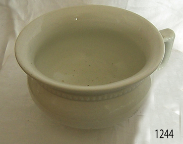
Ceramic - Chamber Pot, J & G Meakin, Early to mid 20th century
... Flagstaff Hill Maritime Museum and Village 89 Merri Street Warrnambool great-ocean-road In the 19th and early 20th centuries, J. & G. Meakin were important, large-scale producers of good quality, ironstone tableware (‘White Granite’ ware) that met a ready market in the United States, South America, Australia, and other traditional British markets. ...In the 19th and early 20th centuries, J. & G. Meakin were important, large-scale producers of good quality, ironstone tableware (‘White Granite’ ware) that met a ready market in the United States, South America, Australia, and other traditional British markets. By the 1890s the company was one of the world’s largest earthenware manufacturers. Although export teaware and tableware was the factory’s staple commodity, Meakin also manufactured toilet ware, kitchenware and a wide range of fancy earthenware. The company was amongst the first British pottery firms to experiment with modernist designs associated with the art deco period. The Moderne' range was introduced in 1929 consisting of an angular shape decorated design with geometric patterns and often highlighted with silver or gold. This range remained in production through the 1930s. Post 1945 the company introduced the streamlined Studio shape (1953) and Horizon shape (1955) both heavily influenced by the Russell Wright ‘American Modern’ tableware. In 1964 a new Studio shape was released with tall streamlined coffee pots used as the background for many contemporary patterns now associated with the 1950s and 1960s. Designs by Jessie Tate and Eve Midwinter, some originally found on Midwinter shapes, also appear on 1970s Studio ware. The Studio range was one of Meakin’s most successful and continued in production until the late-1970s. The enormous range of floral, geometric, and abstract designs make Studio Ware collectible in its own right. In the 1970s and 1980s as part of the Wedgwood Group Meakin produced contemporary products under the 'Bull in a China Shop' and 'Creative Tableware' names. 'Sol' (c.1912-1963), 'Studio' (1953 on) and 'Royal Staffordshire' (post-1968) were important J. & G. Meakin Ltd trade names. Meakin marks are numerous, but all include the J. & G. Meakin name. The significance of this item and pottery generally is that often earthenware is portrayed as being a landmark in the evolution of humanity. This is because these items are the few things from the past that have survived in a tangible form. Pottery is an important functional part of society and it has a critical role to play as it helps archaeologists to date other artefacts of the same time period. Also, the decorations on pottery have told much about the beliefs, lifestyles and lives of the people who bought them and used them. In other words it gives us today a snapshot of society from the past and how people used these items in their daily lives, their likes as well as societal and design trends. Chamber pot ceramic white with handle at side and decoration around top. Unclearwarrnambool, shipwrecked-coast, flagstaff-hill, flagstaff-hill-maritime-museum, shipwreck-coast, flagstaff-hill-maritime-village, champer pot, personal hygiene, personal item, ceramic pot, domestic object -
Federation University Historical Collection
Book, Historic Sites Survey: North Central Study Area, 1979, 1979
... hill...fosterville...coliban water works...green gully...newstead...muckleford forest...costerfield...graytown...bailieston...waranga irrigaiton system...eucalyptus distillery...mia mia bridge...korokubeal township researce...concegella slate quarry...chewton...fryerstown...kingower...timor...talbot...majorca...carisbroook...clunes...st arnaud...taradale...icomos...dunolly...limestone...castlemaine slate quarry...harcourt granite...Barker Library (top floor) Mount Helen goldfields The North Central Study Area included the Shires of Avoca, Bet Bet, east Loddon, Goulburn, Untly, Kara Kara, Korong, Maldon, Marong, Metcalfe, McIvor, Newstead, Strathfieldsaye, Stawell, Talbot, Clunes, Tullaroop and Waranga. castlemaine mount alexander goldfield maldon percydale warrenmang moliagul tarnagulla stuart mill the whipstick whroo rushworth graytown ironbark forest st arnoaud new bendigo landsborough inglewood kurting wedderburn wehla kooroora langham flat mcintyre rheola diamond hill fosterville coliban water works green gully newstead muckleford forest costerfield graytown bailieston waranga irrigaiton system eucalyptus distillery mia mia bridge korokubeal township researce concegella slate quarry chewton fryerstown kingower timor talbot majorca carisbroook clunes st arnaud taradale icomos dunolly limestone castlemaine slate quarry harcourt granite taradale railway viaduct loddon united waterworks trust gouldburn weir carisbrook lock-up history of tree planting in streets history of public reserves r.u. nicholls nurseryman thomas lang francis moss ballarat botanical gardens ballarat school of mines botanical gardens lake wendouree victoria park, ballarat muont holled smith ballaarat old cemetery planting eastern oval ballarat east botanical gardens ballarat east town hall gardens eureka stockade reserve ballarat observatory plantings yarrowee creek plantings yarrowee bluestone channels ballarat woollen mill band and albion mullock heap black hill plantings yarrowee creek channels canadian creek channel specimen vale channel poverty point reserve union jack reserve buninyong imperial mine, buninyong victoria street plantings bridge mall sturt street gardens ballarat avenue of honour plantings white flat oval plantings camp street elms burnt creek 153 page book with white plastic binding. ...The North Central Study Area included the Shires of Avoca, Bet Bet, east Loddon, Goulburn, Untly, Kara Kara, Korong, Maldon, Marong, Metcalfe, McIvor, Newstead, Strathfieldsaye, Stawell, Talbot, Clunes, Tullaroop and Waranga. 153 page book with white plastic binding. It is an historic sites survey for the North Central Study Area commissioned by the Land Conservation Council, the Ministry for COnservation and the Australian Heritage Commission. castlemaine, mount alexander goldfield, maldon, percydale, warrenmang, moliagul, tarnagulla, stuart mill, the whipstick, whroo, rushworth, graytown ironbark forest, st arnoaud, new bendigo, landsborough, inglewood, kurting, wedderburn, wehla, kooroora, langham flat, mcintyre, rheola, diamond hill, fosterville, coliban water works, green gully, newstead, muckleford forest, costerfield, graytown, bailieston, waranga irrigaiton system, eucalyptus distillery, mia mia bridge, korokubeal township researce, concegella slate quarry, chewton, fryerstown, kingower, timor, talbot, majorca, carisbroook, clunes, st arnaud, taradale, icomos, dunolly, limestone, castlemaine slate quarry, harcourt granite, taradale railway viaduct, loddon united waterworks trust, gouldburn weir, carisbrook lock-up, history of tree planting in streets, history of public reserves, r.u. nicholls nurseryman, thomas lang, francis moss, ballarat botanical gardens, ballarat school of mines botanical gardens, lake wendouree, victoria park, ballarat, muont holled smith, ballaarat old cemetery planting, eastern oval, ballarat east botanical gardens, ballarat east town hall gardens, eureka stockade reserve, ballarat observatory plantings, yarrowee creek plantings, yarrowee bluestone channels, ballarat woollen mill, band and albion mullock heap, black hill plantings, yarrowee creek channels, canadian creek channel, specimen vale channel, poverty point reserve, union jack reserve buninyong, imperial mine, buninyong, victoria street plantings, bridge mall, sturt street gardens, ballarat avenue of honour plantings, white flat oval plantings, camp street, elms, burnt creek -
 Bendigo Historical Society Inc.
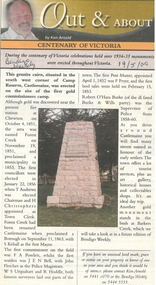
Newspaper - Newspaper articles by Ken Arnold, Out &About, 2000 - 2003
... Granite Rollers 2.6.00 4. Poverty Mine 9.6.00 5. Golden Monument. St Arnaud 16.6.00 6. Turner Statue 7.7.00 7. Gold Monument. High St Golden Square 30.6.00 8. Gold Monument. Howard Square Bendigo 14.7.00 9. Lansell Statue 21.7.00 10. Shelbourne West School 18.8.00 11. Mologa’s State Schools 25.8.00 12. Salinity Stone. Pyramid Hill...Granite Rollers 2.6.00 4. Poverty Mine 9.6.00 5. Golden Monument. St Arnaud 16.6.00 6. Turner Statue 7.7.00 7. Gold Monument. High St Golden Square 30.6.00 8. Gold Monument. Howard Square Bendigo 14.7.00 9. Lansell Statue 21.7.00 10. Shelbourne West School 18.8.00 11. Mologa’s State Schools 25.8.00 12. Salinity Stone. Pyramid Hill ...Ken Arnold is a Bendigo author and publisher.A series of one hundred and thirty-five articles written by Ken Arnold and published in the Bendigo Weekly between 2000 and 2003. Each article has a topic or theme and includes historical information and details. Each article includes a photograph. The articles are stored in a red vinyl covered two ring A5 folder. Index below. Number Article Name Date 1. Centenary of Victoria 19.5.00 2. Storm Water Drain 26.5.00 3. Granite Rollers 2.6.00 4. Poverty Mine 9.6.00 5. Golden Monument. St Arnaud 16.6.00 6. Turner Statue 7.7.00 7. Gold Monument. High St Golden Square 30.6.00 8. Gold Monument. Howard Square Bendigo 14.7.00 9. Lansell Statue 21.7.00 10. Shelbourne West School 18.8.00 11. Mologa’s State Schools 25.8.00 12. Salinity Stone. Pyramid Hill 1.9.00 13. Cairn. Carisbrook 8.9.00 14. Commemorative Markers. Taradale 15.9.00 15. Burke Monument. Castlemaine 22.9.00 16. Cairn. Harcourt area 29.9.00 17. Cairn Marks Gold Route 6.10.00 18. Volcanic Rock Cairn. Woodstock 13.10.00 19. Garfield Water Wheel 20.10.00 20. Anticline. Castlemaine 27.10.00 21. Lawson Bridge 10.11.00 22. Plaque. Sutton Grange area 17.11.00 23. Memorial Cairn. Maryborough 1.12.00 24. Lonely Grave 8.12.00 25. Moonlight Flat Church 5.1.01 26. Historic Church. Near Tullaroop reservoir 12.1.01 27. Granite Statue. Castlemaine 19.1.01 28. Marker. Near Tullaroop reservoir 25.1.01 29. Church Site. Mologa 2.2.01 30. Church Site. Mologa 9.2.01 31. Plaque. Mologa 16.2.01 32. Mincha School 23.2.01 33. Historic Marker. Mincha 2.3.01 34. Expedition Marker. Pyramid Hill 9.3.01 35. Irrigation Marker. Tragowel 16.3.01 36. Mologa School Sites 23.3.01 37. Cairn. Pyramid Hill 30.3.01 38. Plaque. Pyramid Hill 6.4.01 39. Bristol Hill Lookout Tower. Maryborough 12.4.01 40. Eppalock Reservoir 20.4.01 41. Colbinabbin Cairn 27.4.01 42. Mount Macedon Cross 4.5.01 43. Memorial Gateway. Macedon 11.5.01 44. Cairn. Daylesford 18.5.01 45. Grave. Carlsruhe 25.5.01 46. Water Tower. Elmore 1.6.01 47. State School Site. Glenalbyn 8.6.01 48. Cairn. Kanya 15.6.01 49. Lonely Grave. Wedderburn 22.6.01 50. Church Cairn. Glenalbyn 29.6.01 51. Kamarooka School 6.7.01 52. Granite Marker. Moyston 13.7.01 53. Memorial Park. Kerang 20.7.01 54. Water Plaque. Bears Lagoon 27.7.01 55. Cemetery. Bears Lagoon 3.8.01 56. Race Monument 10.8.01 57. Cairn. Pyalong 17.8.01 58. Cairn. In memory of Edward Parker 24.8.01 59. Mt Macedon 31.8.01 60. Mt Macedon Cairn 7.9.01 61. Expedition Pass. Chewton 14.9.01 62. Granite Archway. St Arnaud 21.9.01 63. Stuart Mill School Site 28.9.01 64. School Site. Beazley’s Bridge 5.10.01 65. Fosterville 12.10.01 66. Barnadown 19.10.01 67. Salisbury School Site 26.10.01 68. Cricket History at Wattle Flat 2.11.01 69. School Site. Waterloo Plains 9.11.01 70. Carapooee School Site 11.01 71. Turkish Gun. Maldon 11.01 72. Kooreh 30.11.01 73. Marnoo East School 7.12.01 74. Bulgana Site 14.12.01 75. Emu School 21.12.01 76. Kooroocheang 4.1.02 77. Church Site. Gre Gre North 11.1.02 78. Carmens Tunnel. Maldon 18.1.02 79. Monument. Maldon 25.1.02 80. Woodfull Plaques. Maldon 1.2.02 81. Carapooee. St Peters Anglican Church 8.2.02 82. Cairn. Kingower 15.2.02 83. Cob & Co Stopover. Rheola 22.2.02 84. Flynn Monument 1.3.02 85. The Welcome Stranger. Moliagul 8.3.02 86. Campbell’s Creek Reserve 15.3.02 87. Mine. Fryerstown 22.3.02 88. Escott Grave. Near Chewton 28.3.02 89. School No 808. Kurting area 5.4.02 90. Graves. Bendigo Creek 10.5.02 91. School. Fish Point, Benjeroop North 17.5.02 92. Old Township. Diggora 24.5.02 93. Diggora West (1) 31.5.02 94. Diggora West (2) 7.6.02 95. School No 2735. Gower East 14.6.02 96. Pannoomilloo 21.6.02 97. Kamarooka Settlement 28.6.02 98. Mincha West State School No 1931 5.7.02 99. Bridges. Arnold 12.7.02 100. Woodvale 19.7.02 101. A Famous Son of Raywood. Jack Donaldson 26.7.02 102. Tandarra Area Schools 2.8.02 103. Dingee 9.8.02 104. Avonmore 30.8.02 105. Myola East School 6.9.02 106. Colbinabbin West 13.9.02 107. Colbinabbin West School 20.9.02 108. Runnymede area 27.9.02 109. Wanalta 4.10.02 110. School Sites. Between Wanalta and Carop 11.10.02 111. Burramboot 18.10.02 112. Kangaroo Chair. 25.10.02 113. Mincha South 1.11.02 114. Woodlands Church 8.11.02 115. School site. Sylvaterre 15.11.02 116. Terrick Terrick 22.11.02 117. Leitchville 29.11.02 118. Pennyweight Cemetery. Castlemaine 6.12.02 119. Mincha Area 13.12.02 120. Musk School 20.12.02 121. Dowie Park. Carisbrook 3.1.03 122. Neereman School Site 10.1.03 123. Bald Rock 17.1.03 124. Sylvaterre School Site 24.1.02 125. Carlsruhe 31.1.02 126. Athenaeum. Maldon 7.2.03 127. School. Mincha West 14.2.03 128. Yarraberb 21.2.03 129. Settlement Marker. Ravenswood Estate 28.2.03 130. Comini Reserve. Ravenswood 7.3.03 131. Ironbark and Gold Track. Whroo 14.3.03 132. Burke and Wills Obelisk. Castlemaine 21.3.03 133. James Cook Statue. Myers St Bendigo 28.3.03 134. St Marys Church. Axedale 4 .4.03 135. Butter Factory Site. Warragamba 11.4.03 events, monuments, historical sites, landmarks -
 Sunshine and District Historical Society Incorporated
Archive - City of Sunshine 1984 List Of Factories, K.G. Wilson, L.R. Dryer & R.A. Scaramella, 1984
... Hills & Mason Pty Ltd Hydraulic Equipment & Cylinder Service Pty Ltd Hy-Du-Ex I.C.I. Australia Operations Pty Ltd I.H. Mono & Co. Idea General Engineering Industrial Engineering Invicta Group Industries Pty Ltd K. & B. Windows Pty Ltd K.C. Furniture & Cabinets K.D.S. Manufacturing K.M. Tubular Industries (Aust) Pty Ltd K.P.T. Clothing Manufacturers (K.T.P. Fashions Pty Ltd) Kanga Engineering Pty Ltd Keilor Footwear Pty Ltd Kelgrif Patterns Pty Ltd Klipspringer Pty Ltd Krueger Transports Equipment Pty Ltd Langmar Pty Ltd Layton Granite...Hills & Mason Pty Ltd Hydraulic Equipment & Cylinder Service Pty Ltd Hy-Du-Ex I.C.I. Australia Operations Pty Ltd I.H. Mono & Co. Idea General Engineering Industrial Engineering Invicta Group Industries Pty Ltd K. & B. Windows Pty Ltd K.C. Furniture & Cabinets K.D.S. Manufacturing K.M. Tubular Industries (Aust) Pty Ltd K.P.T. Clothing Manufacturers (K.T.P. Fashions Pty Ltd) Kanga Engineering Pty Ltd Keilor Footwear Pty Ltd Kelgrif Patterns Pty Ltd Klipspringer Pty Ltd Krueger Transports Equipment Pty Ltd Langmar Pty Ltd Layton Granite ...This list of factories in the City of Sunshine is an extract from a report by K.G. Wilson, L.R. Dryer & R.A. Scaramella, prepared for the Melbourne Western Region Commission (WRC). The Melbourne Western Region Commission was a major inter‑municipal planning and advocacy body operating across Melbourne’s western suburbs in the late 1970s and 1980s. It coordinated planning, heritage studies, and regional development across multiple councils. The Commission brought together a broad sweep of western-region councils City of Altona, City of Essendon, City of Footscray, City of Keilor, City of Sunshine, City of Williamstown, Shire of Bacchus Marsh, Shire of Melton & Shire of Werribee. The Melbourne Western Region Commission was one of the most important institutional predecessors to the region’s later heritage, planning, and community‑development frameworks.This report records the business name, type of industry and address of businesses operating in the City of Sunshine in 1984.Factory Name or Occupier A. Korinfsky & Connolly A.J. & J.N. Cook A.R.C. Engineering Pty Ltd Air Refiners Aust Pty Ltd Ajax Pumps Pty Ltd Albion Explosive Factory (Department of Defence) Alliance Printing Co. Pty Ltd Aqua Heat Australia Pty Ltd Aranem Furniture Pty Ltd Arrar Pty Ltd Australain Tube Mills Pty Ltd Australian Quality Closures (Volanda Nominees Pty Ltd) Aztec Sheet Metal Industries Pty Ltd B.G. & J.M. Douglas Nominees Pty Ltd Berkeley Appatel Pty Ltd Berkshire Kitchen Cabinets Pty Ltd Blade Engineering Pty Ltd Boka Engineering Pty Ltd Boneham Engineering Pty Ltd Brand Engineering Toolmaking (Vic) Pty Ltd C.G. Carlton Pty Ltd C.J.T. Niven Pty Ltd C.M.A. Foam Group (Cablemakers Aust Pty Ltd) Campbell & Paterson Engineering Pty Ltd Cargo Newpack Industries City Insulations Pty Ltd Classic Garage Construction Cliff Poole Industries Pty Ltd Collie Cooke Consolidated Conlo Constructions Pty Ltd Connor Shea & Co. Pty Ltd Consolidated Partition Industries Holding Pty Ltd Cosmoplitan Clothing Manfacturers Crea Fashions Pty Ltd Currie Furniture Manufacturing Pty Ltd D. Richardson & Son Ltd Dalco Hardware (Dalco Pty Ltd) Daveyduke Industries (Mimvic Nominees Pty Ltd) Debora Downs Pty Ltd Deer Park Engineering Pty Ltd Deer Park Flyscreens (Azzopardi & Associates Pty Ltd) Dieselflex Pty Ltd Donald Minahan Pty Ltd Drava Continental Butchers & Smallgoods Manufacturer Drilling Equipment (Van Dyke Pty Ltd) Dunham Welding Engineering Pty Ltd E. & F. Industries Pty Ltd E.P. Morrisey & Co. Pty Ltd Elite-Built Holdings Ltd Englehold Engineering Pty Ltd Everlast Steel Products Explosive Factory (Department of Defence Support) Extruded Metals Pty Ltd Exy-Fit Screens F. & D.M. Costa Pty Ltd F. & I. Pfeffer Holdings Pty Ltd F.J. Humphrey Pty Ltd Fallshaw Holdings Pty Ltd Ferrous Forgings Pty Ltd Fleet Engineering Pty Ltd Fletcher Chemical Co. Ltd Franklin Printing & Lithographic Co. Pty Ltd Fraser Cabinets Pty Ltd G. & L. Stone Pty Ltd G.A.M. Engineering Industries Pty Ltd G.P.I. Automotive Products Pty Ltd G.U.D. Manufacturing Co. Pty Ltd G.W. Gregory Engineering (Aust) Pty Ltd General Printing Ink (Aust) Pty Ltd George Press Pty Ltd Griffiths & Beeren Pty Ltd Gubbata Nominess Pty Ltd Harkrome Electroplaters Pty Ltd Hills & Mason Pty Ltd Hydraulic Equipment & Cylinder Service Pty Ltd Hy-Du-Ex I.C.I. Australia Operations Pty Ltd I.H. Mono & Co. Idea General Engineering Industrial Engineering Invicta Group Industries Pty Ltd K. & B. Windows Pty Ltd K.C. Furniture & Cabinets K.D.S. Manufacturing K.M. Tubular Industries (Aust) Pty Ltd K.P.T. Clothing Manufacturers (K.T.P. Fashions Pty Ltd) Kanga Engineering Pty Ltd Keilor Footwear Pty Ltd Kelgrif Patterns Pty Ltd Klipspringer Pty Ltd Krueger Transports Equipment Pty Ltd Langmar Pty Ltd Layton Granite Industries Pty Ltd Lesvos General Products (Gabbia Pty Ltd) Lewis Foundry Lysaght Durham Chemical Company (Austram Corporation Ltd) M.C.I. (Aust) Pty Ltd M.J. Billings M.S.M. Cabinets Pty Ltd Maidstone Cabinet Works Marble Art Company Marib Cutter Sharpening Service Massey-Ferguson (Aust) Ltd McIntyre Steel Industries (Vic) Pty Ltd Midway Press Business Forms Mirna Cabinets Manufacturers Pty Ltd Monsanto Aust Ltd Morgan Cabinets Morris Structural & Engineering Newroll Industries Pty Ltd North Sunshine Cases Novio Insulation (Vic) Pty Ltd Olex Cables (Dunlop Olympic Ltd) Ordnance Factory (Department of Defence Support) P. & S. Siegel Pty Ltd P.S. Fenech Pty Ltd Pacific Carpets Internations Pty Ltd Pattern Productions Pauls Woodworking Pty Ltd Penthouse Furniture Co. Pty Ltd Peter Bouris General Steel Work Pomona Printers Pty Ltd Presstool Manufacturing & Grinding R.E.M. Constructions Pty Ltd R.J. Thompson Nominees Pty Ltd R.M.D. Press Co. Pty Ltd Ralph McMay Ltd Reeco Industries Pty Ltd Regina Terrazzo Tile Robcliff Printing Rockwell Standard of Australia Ltd Saturn Quality Trailers Pty Ltd Sedco Pty Ltd & Sunshine Extrusion Die Co. Pty Ltd Sign City Pty Ltd Smithweld Pty Ltd Smorgan Consolidated Industries Solo Signs Spafco Pty Ltd Stafford Engineering Pty Ltd Star of Paris Pty Ltd Steel Improvement Pty Ltd Sunset Joinery Pty Ltd Sunshine Engineering Pty Ltd Sunshine Group Industries Pty Ltd Sunshine Joinery Pty Ltd Sunshine Metal Polishing Pty Ltd Sunshine Trailers Sunshine Vitreous Enamellers Pty Ltd Sunshine Wrought Iron Super Cartridge Superstyle Tubular Manufacturers Pty Ltd Talkprint Pty Ltd Tenderfoot Shoes Treble Printing Co. Trifoleum Pty Ltd Ultra Scales Pty Ltd United Scales Pty Ltd V.P. Hawthorne Nominees Pty Ltd Vinidex Tubemakers Pty Ltd Vitas Engineering W. & H. General Engineering Pty Ltd W. Pridham (Aust) (Peerless Processing Co Pty Ltd) W.G. Engels Pty Ltd W.L. Allen Foundry Co. Pty Ltd Wakefield Repetition & General Engineers Warren & Brown Co. (Repco Ltd) Westbury Joinery Co. Holdings Pty Ltd Western Containers Pty Ltd & Chanel Press Pty Ltd Westgate Engineering Westside Joinery Pty Ltd (The Bulman Family Trust) Westwork Industries Wiltshire Tools Pty Ltd Worsted Finishers (Aust) Pty Ltd melbourne western region commission -
 Wodonga & District Historical Society Inc
Book - Ghost Towns of the High Country, Luke Steenhuis, 1998
... Towns include Boggy Creek, Brandy Creek, Brocket, Brookville, Buckland, Buckland Upper, Bulgoback, Bulltown, Hogtown, Bullumwaal, Canvastown, Cassilis, Cobbannah, Copenhagen, Dargo High Plains, Dartmouth, Deptford, Gibbo River, Gladstone, Glen Dart, Glen Valley, Glen Wills, Good Luck Creek, Granite Flat, Grant, Hinnomunjie, Howittville, Jeff Davis, Lightning Creek, Louisville, Mayford, Merrijig Creek, Mitchelldale, Mount Elmo, Nugong, Sassafras, Saltpetre, Staleyville, Stirling, Store Creek, Summer Hill, Sunnyside, Tabberabbera, Talbotville, Thiel Town, Tongio West, Waterford, Wentworth River, Winchester, Wombat, Wongungarra, Zulu Creek. ...Stories and information about former towns in and around Victoria's Alpine Region. Towns include Boggy Creek, Brandy Creek, Brocket, Brookville, Buckland, Buckland Upper, Bulgoback, Bulltown, Hogtown, Bullumwaal, Canvastown, Cassilis, Cobbannah, Copenhagen, Dargo High Plains, Dartmouth, Deptford, Gibbo River, Gladstone, Glen Dart, Glen Valley, Glen Wills, Good Luck Creek, Granite Flat, Grant, Hinnomunjie, Howittville, Jeff Davis, Lightning Creek, Louisville, Mayford, Merrijig Creek, Mitchelldale, Mount Elmo, Nugong, Sassafras, Saltpetre, Staleyville, Stirling, Store Creek, Summer Hill, Sunnyside, Tabberabbera, Talbotville, Thiel Town, Tongio West, Waterford, Wentworth River, Winchester, Wombat, Wongungarra, Zulu Creek.non-fictionStories and information about former towns in and around Victoria's Alpine Region. Towns include Boggy Creek, Brandy Creek, Brocket, Brookville, Buckland, Buckland Upper, Bulgoback, Bulltown, Hogtown, Bullumwaal, Canvastown, Cassilis, Cobbannah, Copenhagen, Dargo High Plains, Dartmouth, Deptford, Gibbo River, Gladstone, Glen Dart, Glen Valley, Glen Wills, Good Luck Creek, Granite Flat, Grant, Hinnomunjie, Howittville, Jeff Davis, Lightning Creek, Louisville, Mayford, Merrijig Creek, Mitchelldale, Mount Elmo, Nugong, Sassafras, Saltpetre, Staleyville, Stirling, Store Creek, Summer Hill, Sunnyside, Tabberabbera, Talbotville, Thiel Town, Tongio West, Waterford, Wentworth River, Winchester, Wombat, Wongungarra, Zulu Creek.ghost towns, high country victoria, pioneers, history victoria -
 Wodonga & District Historical Society Inc
Mixed media - John Kenneth Darnton Watson and de Kerilleau Homestead
... The granite foundations of the home were quarried from the hill above the homestead. ...The granite foundations of the home were quarried from the hill above the homestead. ...de Kerilleau was built for William Huon, son of the early pastoralist Paul Huon, in 1870 and named after the family's ancestral estate in France. The original lease of the Wodonga Run was granted to Paul Huon as No. 202 on 7th February 1837, about a year after his cousin Charles Huon had squatted on the land. Kenneth Darnton Watson bought de Kerilleau homestead in 1922 where the Watson family lived for three generations, caring for the land and serving the Wodonga community. Kenneth, his son Ian Darnton Watson and his grandson John Kenneth Darnton Watson all served on the Wodonga Council. The magnificent two storey brick homestead is built on ground above Wodonga Creek. The home of Georgian style consists of eleven rooms and a spacious cellar. At the rear of the main house in a separate single storey building was a large kitchen, pantry and accommodation for a cook and a housemaid. A feature of the homestead is the cast iron lace on the veranda and upper balcony, both supported by caste - iron pillars. The granite foundations of the home were quarried from the hill above the homestead. The enormous Moreton Bay Fig tree which stands to the side of the home was planted when Sir Charles Bowen visited de Kerilleau to mark the opening of the rail line that connects Victoria with New South Wales. Planted in 1873, it is still standing today. This painting was donated to the Wodonga Historical Society by George, Digby & Dugald Watson on behalf of the late John & Chris Watson. John Kenneth Darnton Watson was born on 28 August 1960 in Wodonga. After completing his primary schooling locally, he boarded at Geelong College from 1973. John joined the rowing crews, starting in the 8th VIII crew and reaching the 1st VIII crew in 1978. He received multiple House colours awards for cross country, athletics and rowing and received School colours for rowing. On completion of his schooling, John spent some time jackarooing before studying farm management at Marcus Oldham College in Geelong, Victoria. He then returned home to de Kerilleau, Wodonga to manage the family property. In 1984 John married Christine Honybun, daughter of David Lewis Honybun and Marian Josephine Edkins. John and Christine had three sons. John was community minded and involved in a number of local organisations such as Apex and agricultural societies. He was elected to Wodonga City Council in 1997, serving until 2004. Due to increased pressure on available land to cater for the growth of Wodonga, some of the property was sold and in 2003 John donated 200 ha of Huon Hill ‘s western slopes to the City of Wodonga. After this time, he moved away from farming to become a Hungry Jack's franchisee. In 2009, the hard decision was made to sell de Kerilleau and John and his family moved into Wodonga. After sadly losing Christine to cancer in 2017, John became a member and Deputy Chairperson of the Albury Wodonga Regional Cancer Centre Trust Fund Board and Ambassador for the Sunshine Walk. Tragically after his own cancer battle, John Kenneth Darnton Watson passed away on 24 August 2023, aged 62 years following a life of service to the Wodonga community.This item is significant because it was owned by a prominent Wodonga family and came from a Historic Homestead in WodongaA coloured portrait of John Kenneth Darnton Watson and a painting of de Kerilleau Homestead, the Watson Family home for three generations. The portrait was taken by Peter Charlesworth. The painting is the work of D.K. Ross in 1991.watson family wodonga, de kerilleau homestead, john watson, peter charlesworth -
 Stawell Historical Society Inc
Photograph, Wooden Catholic Church, Reefs Pleasant Creek, built about 1865
... The present St Patricks church is built of granite, quarried in the nearby Black Range with facings of Grampians Freestone and was opened in 1873. Stawell Religion Wooden Church with large bell tower with door at front. The edge slope of Big Hill ...Wooden Catholic Church Reefs built about 1865. Part of a collection of Photographs by Mr. O.G. Armstrong as commissioned by the Shire of Stawell for the Inter-colonial and Paris Exhibition in Melbourne in 1866. This wooden building was built about 1865 on a site held by minors right, near the present Stawell Courthouse. It was situated on a track later to become Patrick St. The present St Patricks church is built of granite, quarried in the nearby Black Range with facings of Grampians Freestone and was opened in 1873. Wooden Church with large bell tower with door at front. The edge slope of Big Hill can be seen at right.stawell religion -
8th/13th Victorian Mounted Rifles Regimental Collection
Document
... Hill. The Light Horse Heritage Troop of 8/13 Victorian Mounted Rifles supported the event. The monument was originally designed to have a 20 metre column to signify the Commonwealth. It was to be erected on a hexagonal base comprising six granite...Hill. The Light Horse Heritage Troop of 8/13 Victorian Mounted Rifles supported the event. The monument was originally designed to have a 20 metre column to signify the Commonwealth. It was to be erected on a hexagonal base comprising six granite ...On Canberra Day held on 12 March 1988, a ceremony is conducted to commemorate the relocation of the Commencement Column Monument (also known as the Commemoration Stone) on Capital Hill. The Light Horse Heritage Troop of 8/13 Victorian Mounted Rifles supported the event. The monument was originally designed to have a 20 metre column to signify the Commonwealth. It was to be erected on a hexagonal base comprising six granite blocks, one from each of the original States of the Commonwealth, on the land axis between Capital Hill and Camp Hill. Whilst the column was never completed, the hexagonal base was constructed and, on 12 March 1913, three foundation stones were laid, by the then Governor-General Lord Denman, the Prime Minister Andrew Fisher, and the Minister of Home Affairs the Hon. King O'Malley, to commemorate the founding and naming of Canberra as the national capital. In 1981 the 63 stones making up the monument were removed from Capital Hill and stored prior to the commencement of excavation work for the new Parliament House. Following a Joint Standing Committee recommendation in 1987, the Commencement Column monument is relocated 'on the land axis immediately north of the parade ground associated with the new Parliament House'. Typed Administrative Instruction for A Squadron 8/13 VMR support to Festival of Canberra 10-13 March 1988. Four pages including nominal roll.Light Horse Troop provided mounted guard for the re-naming of Canberra ceremony and participated in Festival Parade.