Showing 98 items matching "grant taylor"
-
 Australian Queer Archives
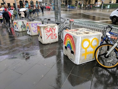
Photograph, Taylor, Grant, 'Marriage equality BollArt', Flinders Street Station, Melbourne, 21 August 2017 (1), Monday, 21 August 2017
... Taylor, Grant...Australian Queer Archives 79-81 Fitzroy Street St Kilda melbourne marriage marriage equality Digital file; JPEG; 4.00 MB 'Marriage equality BollArt', Flinders Street Station, Melbourne, 21 August 2017 (1) Photograph Photograph Taylor, Grant ...Digital file; JPEG; 4.00 MBmarriage, marriage equality -
 Eltham District Historical Society Inc
Document - Property Binder, 906 Main Road, Eltham
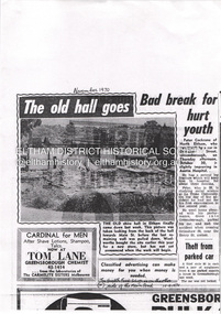
... ...Grant Taylor shop...Newspaper advertisement: Leader Associated Newspapers, Eltham Centenary Supplement, March 30, 1971, Safeway Main Road Eltham Property Shops Businesses Eltham Shire Hall Ashrill Cinema Alistair Knox Eltham arcade Gordon Ford Eltham Village Music Centre Woolworth supermarket Eltham K G McGorlick (Real Estate) Pty Ltd Bimbi Baby Wear Kinderplay Eltham Hardware & Plumbing Supplies Pty Ltd E J Doherty Pty Ltd Cafe de Chine Eltham Hotel Manser Meats Gordon Knight Discounts Bill Penna Pharmacy Eltham Village Radio and TV Gilbertsons Eedens Art Supplies Penguin Dry Cleaners Bend of Isles shop Jeaneration shop Pauls Cycles and Sports Eltham Bread Inn Sussans shop Lenards Hair Care Grant Taylor shop Eltham Village Fruit Barn Madeleine's Cake Ship and Bakery Eltham Gourmet Poultry and Game Ella Bache Eltham Alta Vita Cafe Bar Restaurant Anna Carlucci Brumby's Bakery Eltham Kip McGrath Education Centre Eltham Biba hairdresser Eltham Just Sport Eltham Gifts of Elegance shop Eltham Bronnie Hattam Angela Lampard Bob Bruce Magenta Creative Jewellery Kate Maroney Andrew Rose Fine Fruit of Eltham shop Safeway Supermarket Miscellaneous clippings, notes, photocopies, etc held on the subject property. 906 Main Road, Eltham Document Property Binder ...Newspaper article: unidentified possibly Diamond Valley News, November 1970: The old hall goes, photograph of old shire hall part-demolished. Newspaper article: unidentified possibly Diamond Valley News, November 1970: Bad break for hurt youth, Peter Cockrane injured in car accident. Letter Eltham Film Society to Eltham Historical Society, 18 May 1972: Advising of demolition threat to building housing Ashrill Cinema. Newspaper article: The Valley Voice, 19 October 1978, A birds eye view, Lands Department photograph at 15,500 feet, Alistair Knox quoted re style of Eltham arcade in contrast to shopping centres, advertisements for local businesses. Newspaper advertisement: Diamond Valley News, 27 May 1980, Eltham Village Music Centre. Newspaper article: Diamond Valley News, 10 September 1985, Supermarket is now here, photograph of Main Road looking north from corner Dudley Street. Newspaper article: Diamond Valley News, 10 September 1985, Woolworths Arcade Eltham, 14th birthday Sell-a-bration! photograph of Woolworth site. Photocopy advertising flier Coles Eltham and Arcade shops, 1 December 1999. Newspaper advertisement: Diamond Valley News, 16 November 1994, Application for Planning Permit. Newspaper article: Nillumbik Mail, 26 July 2000, A GST-free shop, Eltham Village Fruit Barn. Newspaper advertisement: Diamond Valley Leader, 22 June 2005, Alta Vita restaurant. Newspaper article: Diamond Valley Leader, 6 July 2005, Skin care for individuals, Ella Bache, Shop 8. Newspaper article: Diamond Valley Leader, 27 July 2005, Great all day food and service, Alta Vita Cafe/Bar/Restaurant, owner Anna Carlucci. Newspaper advertisement: Valley Weekly, 17 August 2005, Brumby's Bakery. Newspaper article: Valley Weekly, 17 August 2005, Plus for rides, Traders charged up to help scooter users, power points will be provided in Eltham shopping district for scooter and electric wheelchair users, photograph of Bronnie Hattam, Angela Lampard and Bob Bruce. Newspaper article: Diamond Valley Leader, 28 March 2007, Fine touch for jewellery, Magenta Creative Jewellery, owners Kate Maroney and Andrew Rose. Newspaper advertisement: Diamond Valley Leader, 30 July 2008, Fine Fruit of Eltham shop. Appointment Card (x3): 2017, no date, 2023, Ella Bache Eltham. Newspaper advertisement: Leader Associated Newspapers, Eltham Centenary Supplement, March 30, 1971, Safewaymain road, eltham, property, shops, businesses, eltham shire hall, ashrill cinema, alistair knox, eltham arcade, gordon ford, eltham village music centre, woolworth supermarket eltham, k g mcgorlick (real estate) pty ltd, bimbi baby wear, kinderplay, eltham hardware & plumbing supplies pty ltd, e j doherty pty ltd, cafe de chine, eltham hotel, manser meats, gordon knight discounts, bill penna pharmacy, eltham village radio and tv, gilbertsons, eedens art supplies, penguin dry cleaners, bend of isles shop, jeaneration shop, pauls cycles and sports, eltham bread inn, sussans shop, lenards hair care, grant taylor shop, eltham village fruit barn, madeleine's cake ship and bakery, eltham gourmet poultry and game, ella bache eltham, alta vita cafe bar restaurant, anna carlucci, brumby's bakery eltham, kip mcgrath education centre eltham, biba hairdresser eltham, just sport eltham, gifts of elegance shop eltham, bronnie hattam, angela lampard, bob bruce, magenta creative jewellery, kate maroney, andrew rose, fine fruit of eltham shop, safeway supermarket -
 Federation University Historical Collection
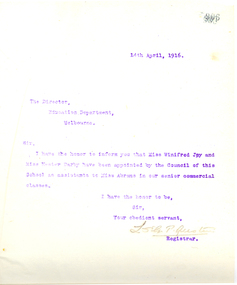
Letter - Letterbook, Ballarat School of Mines Letterbook, 1915 to 1916, 1916
... ...grant taylor...Barker Library (top floor) Mount Helen goldfields The letter book related to outward letters from the Ballarat School of Mines. ballarat school of mines correspondence murphy vaughan victor greenhalgh irvine coulter lancelot austin l.s.g.p. austin adcock james bickett bickett tunbridge tucker desnoy phillips edgar mcconnon revill tinworth r.o. buchanan john dulfer stanley westcott wolfram assay anzac medallion beaufort house ballarat eight hours' anniversary last chance mine evan walker norman carmichael doney thomas doolan harold wakeling bowman james early garry eason abrams bennett duthie harry fern hetherington hutchinson collyeer colom carew-smyth ponsonby carew-smyth donald clark george swinburne bev syliva hestor darby joy winifred barry judd c.c. campbell cathcart centrel gold mining co adcockbawden benevolent asylum ditchburn doctor spring doepel and chandler eureka tile company pitfield edwads pyrites works embling fleay c.e. fenner mount rowan gower greenhalgh c. hosking murtoa c.a. hoadley harold herbert jolly kenny kelsall kerr architect a.m. lilburne lemmon andrew land leipson h.s. lawson a. levy scarsdale gold mines w.k. moss fred martell e.j. mcconnen read murphy h. morris leongatha maurice claude j. middleton j.c. molley e. merlin e.f. pitman p. pringle rumble dr robin edgar richard g. remfry g. robertson james rich a. ross d. l. stirling s. stretch c. skilbeck r. strachan w.k. thomson grant taylor j.h. tundbury v.e. reeves tin mining co. hobart vernon hilda wardle daylesford waller whitloa w. watson b. whitington j.b. robinson k. hamilton photography j.m. sutherland j.h. scullin scholarship w.h. wesley gundagai a.t. o'meara associated smelters port pirrie assayer telegraphy t. williams d.l. stirling edward finnis norman tinworth j.y. mcdonald h.s. summers geology homeward bound bon accord gmc e.t. vane a.d. dunstan maughan cox g.s. richards westcott w.l. carroll turnbull l. vernon s. nightingale cathcart central gold mining company cathcart a.j. moffit v.e. reevesr. mcmillan w. nankervis w.h. clutterbuck j.m. wesley e. dooley olive mckillop dana street primary school shelter shed ballarat junior technical school british nationality and aliens act war relief fund s. hylton bravo queensland molasses co ethel merlin a.e. poulton commercial winifred joy c. adcock lancelot st.g.p. austin herbert p. bennett a. bray fonald clark walter collyer o.f. colom g.e. desnoy f.w.r. doney brian h. duthie a. gordon g.m. hetherington kath hutchinson baryr judd j. kean john y. mcdonald j. murray a.f. phillips c.c. phillips john mck. sutherland bev sylvia r.e. tunbridge miachel vaughan p. vawdey h.j. vernon harold g. wakeling pharmacy board pharmacy r. cutter ballarat technical art school building dalgety & co. h.s.w. lawson a.h. powell australian institute of engineers eight hours' anniversary committee silberberg beckman's thermometer Miss Abrams Business College A bound leatherbound book with marble endpapers. ...The letter book related to outward letters from the Ballarat School of Mines.A bound leatherbound book with marble endpapers. The contents are copies of outward letters from the Ballarat School of Mines from July 1915 to May 1916. Page 807 relates to the Ballarat Eight Hours' Anniversary Committee (J. Kean) Page 906 - Letter from L. Austin (Ballarat School of Mines Registrar) concerning the appointment of Winifred Joy and Hestor Darby as assistants to Miss Abrams to the Ballarat School of Mines Senior Commercial Classes. ballarat school of mines, correspondence, murphy, vaughan, victor greenhalgh, irvine coulter, lancelot austin, l.s.g.p. austin, adcock, james bickett, bickett, tunbridge, tucker, desnoy, phillips, edgar mcconnon, revill tinworth, r.o. buchanan, john dulfer, stanley westcott, wolfram, assay, anzac medallion, beaufort house, ballarat eight hours' anniversary, last chance mine, evan walker, norman carmichael, doney, thomas doolan, harold wakeling, bowman, james early, garry eason, abrams, bennett, duthie, harry fern, hetherington, hutchinson, collyeer, colom, carew-smyth, ponsonby carew-smyth, donald clark, george swinburne, bev syliva, hestor darby, joy winifred, barry judd, c.c. campbell, cathcart centrel gold mining co, adcockbawden, benevolent asylum, ditchburn, doctor spring, doepel and chandler, eureka tile company, pitfield, edwads pyrites works, embling, fleay, c.e. fenner, mount rowan, gower, greenhalgh, c. hosking, murtoa, c.a. hoadley, harold herbert, jolly, kenny, kelsall, kerr, architect, a.m. lilburne, lemmon, andrew land, leipson, h.s. lawson, a. levy, scarsdale gold mines, w.k. moss, fred martell, e.j. mcconnen, read murphy, h. morris, leongatha, maurice claude, j. middleton, j.c. molley, e. merlin, e.f. pitman, p. pringle, rumble, dr robin, edgar richard, g. remfry, g. robertson, james rich, a. ross, d. l. stirling, s. stretch, c. skilbeck, r. strachan, w.k. thomson, grant taylor, j.h. tundbury, v.e. reeves, tin mining co. hobart, vernon, hilda wardle, daylesford, waller, whitloa, w. watson, b. whitington, j.b. robinson, k. hamilton, photography, j.m. sutherland, j.h. scullin, scholarship, w.h. wesley, gundagai, a.t. o'meara, associated smelters port pirrie, assayer, telegraphy, t. williams, d.l. stirling, edward finnis, norman tinworth, j.y. mcdonald, h.s. summers, geology, homeward bound bon accord gmc, e.t. vane, a.d. dunstan, maughan, cox, g.s. richards, westcott, w.l. carroll, turnbull, l. vernon, s. nightingale, cathcart central gold mining company cathcart, a.j. moffit, v.e. reevesr. mcmillan, w. nankervis, w.h. clutterbuck, j.m. wesley, e. dooley, olive mckillop, dana street primary school shelter shed, ballarat junior technical school, british nationality and aliens act, war relief fund, s. hylton bravo, queensland molasses co, ethel merlin, a.e. poulton, commercial, winifred joy, c. adcock, lancelot st.g.p. austin, herbert p. bennett, a. bray, fonald clark, walter collyer, o.f. colom, g.e. desnoy, f.w.r. doney, brian h. duthie, a. gordon, g.m. hetherington, kath hutchinson, baryr judd, j. kean, john y. mcdonald, j. murray, a.f. phillips, c.c. phillips, john mck. sutherland, bev sylvia, r.e. tunbridge, miachel vaughan, p. vawdey, h.j. vernon, harold g. wakeling, pharmacy board, pharmacy, r. cutter, ballarat technical art school building, dalgety & co., h.s.w. lawson, a.h. powell, australian institute of engineers, eight hours' anniversary committee, silberberg, beckman's thermometer, miss abrams business college -
 Blackburn Cricket Club
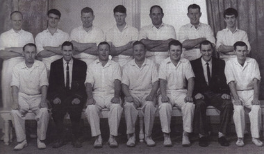
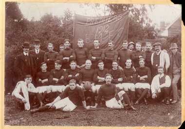
Premiers 1961-62 1st XI A Grade, 1961-62 1st XI A Grade Premiers
... grant...alan taylor...Team Standing (L-R): George Allerton, Keith Sturgeon, George Stone, Brian Pickett, Keith Blackley, Jim Robertson, Peter Grant. Sitting: Alan Taylor, Les Reed (President), Neveille Jacobs (vc), Don Meehan (c), Stuart Walker, Allan Berry (Sec), Ken Henwood....Team Standing (L-R): George Allerton, Keith Sturgeon, George Stone, Brian Pickett, Keith Blackley, Jim Robertson, Peter Grant. Sitting: Alan Taylor, Les Reed (President), Neveille Jacobs (vc), Don Meehan (c), Stuart Walker, Allan Berry (Sec), Ken Henwood. cricket a grade blackburn blackburn cricket club cricket whites 1961-62 a grade premiers george allerton keith sturgeon george stone brian pickett keith blackley jim robertson peter grant alan taylor les reed neveille jacobs don meehan stuart walker allan berry ken henwood Black and white portrait of the cricket team anf officials. 1961-62 1st XI A Grade Premiers Premiers 1961-62 1st XI A Grade ...How many matches did these men play? Away games, home games? Any remarkable runs or scores? How long had each been playing? Were they professionals or amateurs? 1961-62 brought the Blackburn Cricket Club a triple premiership winning the A Grade, C Grade and D Grade flags in addition to the Under 16s. Team Standing (L-R): George Allerton, Keith Sturgeon, George Stone, Brian Pickett, Keith Blackley, Jim Robertson, Peter Grant. Sitting: Alan Taylor, Les Reed (President), Neveille Jacobs (vc), Don Meehan (c), Stuart Walker, Allan Berry (Sec), Ken Henwood.Black and white portrait of the cricket team anf officials. cricket, a grade, blackburn, blackburn cricket club, cricket whites, 1961-62, a grade premiers, george allerton, keith sturgeon, george stone, brian pickett, keith blackley, jim robertson, peter grant, alan taylor, les reed, neveille jacobs, don meehan, stuart walker, allan berry, ken henwood -
 Expression Australia
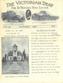
Newsletter, The Victorian Deaf - Nov 1929
... a. c. muir, william p. muir, w. g. marsh, ymca, john muir, armsstrong, abraham, peacock, simpson hill, hoath, thomas purves, j. stephens, a. course, f. crowther, f. garfield, g. sheahan, h.s. tainton, w. wilcox, alice graham, bessie graham, brooke nicholls, j. m. johnston, deaf women's guild, mrs moss, s. moss, t. peters, frewin, thelma stephens, lacrosse, cricket, lodavia nicholson, elsie stephens, o'callaghan, deaf worker's club, geelong, m. gibson, j. boortz, a. taylor, walter grant, byron taylor, g. edwards, reginald gilbert, mrs cross, mrs hartley, john anderson, w. moloney, a. collins, colin johns, ferguson, damman, j. hunt, c. hunt, winn, j. kenworthy, w. mcmillen, g. henry, l. sanders, m. aram, moss, j. hunt, w. rees, d. driscoll, daphne tyzzer, roy martyr, emily anderson, pat cunningham, patrick o'keefe...Expression Australia Level 4 340 Albert Street East Melbourne melbourne Bi-Monthly News Letter - Under the auspices of the Deaf Committee of the Adult Deaf and Dumb Society of Victoria 'The Victorian Deaf' Newsletter is a significant publication as an historical record giving and insight into the people, activities and events of the Deaf Community in Victoria. a. c. muir, william p. muir, w. g. marsh, ymca, john muir, armsstrong, abraham, peacock, simpson hill, hoath, thomas purves, j. stephens, a. course, f. crowther, f. garfield, g. sheahan, h.s. tainton, w. wilcox, alice graham, bessie graham, brooke nicholls, j. m. johnston, deaf women's guild, mrs moss, s. moss, t. peters, frewin, thelma stephens, lacrosse, cricket, lodavia nicholson, elsie stephens, o'callaghan, deaf worker's club, geelong, m. gibson, j. boortz, a. taylor, walter grant, byron taylor, g. edwards, reginald gilbert, mrs cross, mrs hartley, john anderson, w. moloney, a. collins, colin johns, ferguson, damman, j. hunt, c. hunt, winn, j. kenworthy, w. mcmillen, g. henry, l. sanders, m. aram, moss, j. hunt, w. rees, d. driscoll, daphne tyzzer, roy martyr, emily anderson, pat cunningham, patrick o'keefe Vol. 25 No. 2 November 1929; Size 27cmHx21cmW; 15 pages The Victorian Deaf - Nov 1929 Newsletter ...Bi-Monthly News Letter - Under the auspices of the Deaf Committee of the Adult Deaf and Dumb Society of Victoria 'The Victorian Deaf' Newsletter is a significant publication as an historical record giving and insight into the people, activities and events of the Deaf Community in Victoria.Vol. 25 No. 2 November 1929; Size 27cmHx21cmW; 15 pagesa. c. muir, william p. muir, w. g. marsh, ymca, john muir, armsstrong, abraham, peacock, simpson hill, hoath, thomas purves, j. stephens, a. course, f. crowther, f. garfield, g. sheahan, h.s. tainton, w. wilcox, alice graham, bessie graham, brooke nicholls, j. m. johnston, deaf women's guild, mrs moss, s. moss, t. peters, frewin, thelma stephens, lacrosse, cricket, lodavia nicholson, elsie stephens, o'callaghan, deaf worker's club, geelong, m. gibson, j. boortz, a. taylor, walter grant, byron taylor, g. edwards, reginald gilbert, mrs cross, mrs hartley, john anderson, w. moloney, a. collins, colin johns, ferguson, damman, j. hunt, c. hunt, winn, j. kenworthy, w. mcmillen, g. henry, l. sanders, m. aram, moss, j. hunt, w. rees, d. driscoll, daphne tyzzer, roy martyr, emily anderson, pat cunningham, patrick o'keefe -
 Bacchus Marsh & District Historical Society
Photograph, Bacchus Marsh Football Club Premiers, 1912
... The names of the players are not recorded on this photo, but the Express records the names of Marsh, Fairbank, Northcott, Palmer, Roy Simpson, Morris, Tom Grant, Jack Taylor, Bert Jones, Portingale (c.), Densley Bros., Wittick, Harry Grant, Leonard, Odgers, Bodycote....The names of the players are not recorded on this photo, but the Express records the names of Marsh, Fairbank, Northcott, Palmer, Roy Simpson, Morris, Tom Grant, Jack Taylor, Bert Jones, Portingale (c.), Densley Bros., Wittick, Harry Grant, Leonard, Odgers, Bodycote. ...This photo is one of the oldest known photographic records of an Australian Rules football team in the Bacchus Marsh area. Australian Rules football was played in this area as early as the 1870s. An organized competition to play regular matches was formed in the early years of the twentieth century. This photo records the premiership winning team of 1912 in the match played against Melton. The match was reported in the Bacchus Marsh Express of 31 August 1912. The names of the players are not recorded on this photo, but the Express records the names of Marsh, Fairbank, Northcott, Palmer, Roy Simpson, Morris, Tom Grant, Jack Taylor, Bert Jones, Portingale (c.), Densley Bros., Wittick, Harry Grant, Leonard, Odgers, Bodycote.This item has historic and social significance as an image of one of the early sporting teams of Bacchus Marsh and district. It is a typical example of team photographs of this era. It is evidence of the transition of football from a social informal setting to an organised activity and signals the growth of importance of sport, in this case Australian Rules football, as a cultural and social activity central to the Australian ethos.A sepia photograph print mounted on mounting board, showing a group of 27 men arranged in three rows in front of a banner reading PREMIERS 1912 BMFC. Eighteen men are in football guernseys, nine in civilian clothes, three of whom are carrying towels over their shoulders. One player, very likely the captain, is holding a football. The photo is taken in an outdoor setting. On the reverse in pencil: 'Middle row - 5th from left JOHN WITTICK.'bacchus marsh football club, australian rules football -
 Eltham District Historical Society Inc
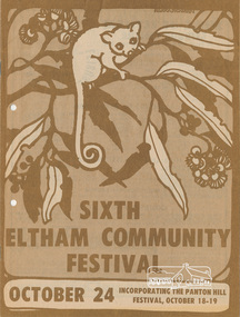
Program, Program of Events, Sixth Eltham Community Festival, October 24, 1980 incorporating the Panton Hill Festival, October 18-19, 1980
... Event program, 81 events, Sat-Sun 18-19 Oct, Wed 22 Oct, Fri 24 Oct-Sun 2 Nov, Tue 4 Nov and Sat 8 Nov and local advertisers Alan Marshall (Pioneers and Painters), Aquapilca, Artist Showcase, Bimbadeen Galley Pty Ltd, Bimbi World, Blondies Fashion Boutique, Briar Hill Timber & Trading, Cheepa Toys, Country Art Store, Debonaire Air Conditioning Pty Ltd, Diamond Valley Drapes, Diamond Valley News, Diamond Valley Photographic Services Pty Ltd, Diamond Valley Windscreens, Don Brown, Eccacentre, Economy Timber & Hardware, Edens Hobbycraft & Art Supplies, Eltham Gallery, Eltham Hardware & Plumbing Supplies Pty Ltd, Eltham Jeanery, Eltham Living and Learning Centre, Eltham Produce Store, Grant Taylor, Grimshaw Motor Cycles, Just Looking Furniture, Kenton Footwear, Lamers Construction Pty Ltd, Leisure Centre, Lovittools, Lower Plenty Sports Centre, Montflora, Montmorency Gospel Chapel, Montmorency Pets, Montsalvat, Para Furnishings, Paul's Sports Store, Pegasus Interiors, Pioneers and Painters, Program, R & S Slocum Floorcovering Pty Ltd, R. & S. ...Event program, 81 events, Sat-Sun 18-19 Oct, Wed 22 Oct, Fri 24 Oct-Sun 2 Nov, Tue 4 Nov and Sat 8 Nov and local advertisers Alan Marshall (Pioneers and Painters), Aquapilca, Artist Showcase, Bimbadeen Galley Pty Ltd, Bimbi World, Blondies Fashion Boutique, Briar Hill Timber & Trading, Cheepa Toys, Country Art Store, Debonaire Air Conditioning Pty Ltd, Diamond Valley Drapes, Diamond Valley News, Diamond Valley Photographic Services Pty Ltd, Diamond Valley Windscreens, Don Brown, Eccacentre, Economy Timber & Hardware, Edens Hobbycraft & Art Supplies, Eltham Gallery, Eltham Hardware & Plumbing Supplies Pty Ltd, Eltham Jeanery, Eltham Living and Learning Centre, Eltham Produce Store, Grant Taylor, Grimshaw Motor Cycles, Just Looking Furniture, Kenton Footwear, Lamers Construction Pty Ltd, Leisure Centre, Lovittools, Lower Plenty Sports Centre, Montflora, Montmorency Gospel Chapel, Montmorency Pets, Montsalvat, Para Furnishings, Paul's Sports Store, Pegasus Interiors, Pioneers and Painters, Program, R & S Slocum Floorcovering Pty Ltd, R. & S. ...Event program, 81 events, Sat-Sun 18-19 Oct, Wed 22 Oct, Fri 24 Oct-Sun 2 Nov, Tue 4 Nov and Sat 8 Nov and local advertisers Alan Marshall (Pioneers and Painters), Aquapilca, Artist Showcase, Bimbadeen Galley Pty Ltd, Bimbi World, Blondies Fashion Boutique, Briar Hill Timber & Trading, Cheepa Toys, Country Art Store, Debonaire Air Conditioning Pty Ltd, Diamond Valley Drapes, Diamond Valley News, Diamond Valley Photographic Services Pty Ltd, Diamond Valley Windscreens, Don Brown, Eccacentre, Economy Timber & Hardware, Edens Hobbycraft & Art Supplies, Eltham Gallery, Eltham Hardware & Plumbing Supplies Pty Ltd, Eltham Jeanery, Eltham Living and Learning Centre, Eltham Produce Store, Grant Taylor, Grimshaw Motor Cycles, Just Looking Furniture, Kenton Footwear, Lamers Construction Pty Ltd, Leisure Centre, Lovittools, Lower Plenty Sports Centre, Montflora, Montmorency Gospel Chapel, Montmorency Pets, Montsalvat, Para Furnishings, Paul's Sports Store, Pegasus Interiors, Pioneers and Painters, Program, R & S Slocum Floorcovering Pty Ltd, R. & S. Trading, R.F. & D.M. Kidd, Sa Boutique, Skybeam Antennas, Studio Papilio, Style Interiors, The Living Water Bookshop, Todaro Coiffure, Valley Tiffany Lighting, W. Hutchison, Were Street Theatre, Zettlock16 pages, stapled, coloured1980, alan marshall, eltham festival, mal harrop, pioneers and painters -
 Bendigo Historical Society Inc.
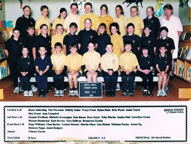
Photograph - GOLDEN SQUARE MAPLE STREET P.S. COLLECTION: PHOTOGRAPH - GRADE 5-6 S 1999
... Taylor... Max Grant...Their names are: 3rd Row L-R: Reece Alderding, Tim Marmion, Felicity Usher, Tracey Priest, Dylan Hunt, Erin Wyatt, Jessie Taylor, Max Grant, Amy Campbell. 2nd Row L-R: Jacquie Fordham, Michele Brannagan, Sam Bacon, Kate Geyer, Toby Martin, Jessica Hall, Llewellyn Green, Miriam Henderson, Kyle Bevans, Tara Sullivan, Broderick Gordes. ...Their names are: 3rd Row L-R: Reece Alderding, Tim Marmion, Felicity Usher, Tracey Priest, Dylan Hunt, Erin Wyatt, Jessie Taylor, Max Grant, Amy Campbell. 2nd Row L-R: Jacquie Fordham, Michele Brannagan, Sam Bacon, Kate Geyer, Toby Martin, Jessica Hall, Llewellyn Green, Miriam Henderson, Kyle Bevans, Tara Sullivan, Broderick Gordes. ...Golden Square Maple Street P.S. Collection - Photograph - Grade 5-6 S 1999 class and their teacher. Their names are: 3rd Row L-R: Reece Alderding, Tim Marmion, Felicity Usher, Tracey Priest, Dylan Hunt, Erin Wyatt, Jessie Taylor, Max Grant, Amy Campbell. 2nd Row L-R: Jacquie Fordham, Michele Brannagan, Sam Bacon, Kate Geyer, Toby Martin, Jessica Hall, Llewellyn Green, Miriam Henderson, Kyle Bevans, Tara Sullivan, Broderick Gordes. Front Row L-R: Hope Williams, Chas Barker, Lindon Stewart, Martin Olsen, Lisa Haines, Nicholas Parker, James Ng, Rebecca Negus, Jessie Rodgers. Absent: Clinton Turner. Teacher: B Savy. Principal: Mr David Robins.Arthur Reed Photoseducation, primary, golden square laurel st p.s., golden square maple street p.s. collection - photograph - grade 5-6 s 1999, reece alderding, tim marmion, felicity usher, tracey priest, dylan hunt, erin wyatt, jessie taylor, max grant, amy campbell, jacquie fordham, michele brannagan, sam bacon, kate geyer, toby martin, jessica hall, llewellyn green, miriam henderson, kyle bevans, tara sullivan, broderick gordes, hope williams, chas barker, lindon stewart, martin olsen, lisa haines, nicholas parker, james ng, rebecca negus, jessie rodgers, clinton turner, b savy, mr david robins, arthur reed photos -
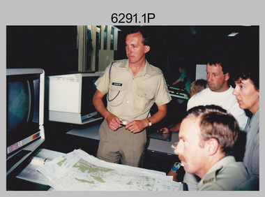
 Bendigo Military Museum
Photograph - Prime Minister’s Visit to the Army Survey Regiment, Fortuna, Bendigo, 1990
... Hawke AC GCL, OC MAJ Neil Taylor, SPR Grant Davis, SSGT Graham Johnson. .17) - Photo, colour, 1990, Cartographic Squadron’s Automap 2 system L to R: SSM WO1 Graham Ragless, OC MAJ Neil Taylor, Prime Minister Hon. ...Hawke AC GCL, OC MAJ Neil Taylor, SPR Grant Davis, SSGT Graham Johnson. .17) - Photo, colour, 1990, Cartographic Squadron’s Automap 2 system L to R: SSM WO1 Graham Ragless, OC MAJ Neil Taylor, Prime Minister Hon. ...These photographs of Prime Minister Hon RJ Hawke’s visit to the Army Survey Regiment were taken at Fortuna, Bendigo in March 1990. This occasion was one of several events held to commemorate the 75th anniversary of the formation of the Royal Australian Survey Corps. The one-hour visit was a rare opportunity for RA Svy to demonstrate to its Prime Minister the unit’s important role as Defence’s map production agency, its technical equipment, and its economic importance to Bendigo. It was also an opportunity to take him through historic Fortuna Villa. This occasion is covered in more detail in page 143 of Valerie Lovejoy’s book 'Mapmakers of Fortuna – A history of the Army Survey Regiment’ ISBN: 0-646-42120-4. Refer to Item 6247.30P for more photos of the Open Day. This set of 34 photographs of Prime Minister Hon RJ Hawke’s visit to the Army Survey Regiment was taken at Fortuna, Bendigo in March 1990. The colour photographs were printed on photographic paper and are part of the Army Survey Regiment’s Collection. The photographs were scanned at 300 dpi. Film negatives are not scanned. .1) - Photo, colour, 1990, L to R: Prime Minister Hon. R.J. Hawke AC GCL greeted by the CO LTCOL Rene van den Tol and the press. In foreground L to R: John Brumby AO, 2IC MAJ Duncan Burns facing away. .2) & .3) - Photo, colour, 1990, Prime Minister Hon. R.J. Hawke AC GCL entering the front steps of Fortuna Villa. L to R: ADJT CAPT Peter Parkes, 2IC MAJ Duncan Burns, Bob Hawke, John Brumby AO (partially obscured), CO LTCOL Rene van den Tol. .4) - Photo, colour, 1990, Prime Minister Hon. R.J. Hawke AC GCL signs the Visitors’ Book in Fortuna Villa’s foyer. L to R: John Brumby AO CO LTCOL Rene van den Tol. .5) - Photo, colour, 1990, The tour of the Army Survey Regiment begins on the rear balcony. L to R: CO LTCOL Rene van den Tol, Prime Minister Hon. R.J. Hawke AC GCL, John Brumby AO, 2IC MAJ Duncan Burns, unidentified. .6) - Photo, colour, 1990, central corridor L to R: 2IC MAJ Duncan Burns, Prime Minister Hon. R.J. Hawke AC GCL, John Brumby AO, CO LTCOL Rene van den Tol. .7) & .8) - Photo, colour, 1990, top of the rear balcony steps L to R: John Brumby AO, Prime Minister Hon. R.J. Hawke AC GCL, CO LTCOL Rene van den Tol, unidentified .9) - Photo, colour, 1990, OC MAJ Peter Clark greets the Prime Minister Hon. R.J. Hawke AC GCL outside Air Survey Squadron. .10) - Photo, colour, 1990, L to R: OC MAJ Neil Taylor and SSM WO1 Graham Ragless greet the Prime Minister Hon. R.J. Hawke AC GCL inside Cartographic Squadron. CO LTCOL Rene van den Tol and John Brumby AO at right. .11) - Photo, colour, 1990, tour of Cartographic Squadron begins L to R: John Brumby AO, CO LTCOL Rene van den Tol, Prime Minister Hon. R.J. Hawke AC GCL OC MAJ Neil Taylor. .12) - Photo, colour, 1990, tour of Cartographic Squadron L to R: SSM WO1 Graham Ragless, OC MAJ Neil Taylor, Prime Minister Hon. R.J. Hawke AC GCL. .13) - Photo, colour, 1990, Cartographic Squadron’s Automap 2 system L to R: 2IC MAJ Duncan Burns, John Brumby AO, CO LTCOL Rene van den Tol, Prime Minister Hon. R.J. Hawke AC GCL, OC MAJ Neil Taylor. .14) - Photo, colour, 1990, Cartographic Squadron’s Automap 2 system L to R: 2IC MAJ Duncan Burns, John Brumby AO, CO LTCOL Rene van den Tol, Prime Minister Hon. R.J. Hawke AC GCL, OC MAJ Neil Taylor, ADJT CAPT Peter Parkes. .15) - Photo, colour, 1990, Cartographic Squadron’s Automap 2 system L to R: OC MAJ Neil Taylor, Prime Minister Hon. R.J. Hawke AC GCL, CO LTCOL Rene van den Tol, John Brumby AO, SPR Stewart Adrain. .16) - Photo, colour, 1990, Cartographic Squadron’s Automap 2 system L to R: ADJT CAPT Peter Parkes, unidentified, John Brumby AO, Prime Minister Hon. R.J. Hawke AC GCL, OC MAJ Neil Taylor, SPR Grant Davis, SSGT Graham Johnson. .17) - Photo, colour, 1990, Cartographic Squadron’s Automap 2 system L to R: SSM WO1 Graham Ragless, OC MAJ Neil Taylor, Prime Minister Hon. R.J. Hawke AC GCL, unidentified, CO LTCOL Rene van den Tol, SSGT Graham Johnson. .18) - Photo, colour, 1990, Cartographic Squadron’s Automap 2 system L to R: OC MAJ Neil Taylor, Prime Minister Hon. R.J. Hawke AC GCL, CO LTCOL Rene van den Tol, ADJT CAPT Peter Parkes. In foreground L to R: CPL Andy Lucas, SPR Geofrey Steegstra, SPR Gordon Santo, SSGT Graham Johnson. .19) - Photo, colour, 1990, Cartographic Squadron’s Automap 2 system L to R: SSM WO1 Graham Ragless, 2IC MAJ Duncan Burns, John Brumby AO, Prime Minister Hon. R.J. Hawke AC GCL, OC MAJ Neil Taylor. .20) - Photo, colour, 1990, Tour group enroute to Lithographc Squadron L to R: John Brumby AO, ADJT CAPT Peter Parkes, Prime Minister Hon. R.J. Hawke AC GCL, unidentified (x2), 2IC MAJ Duncan Burns, CO LTCOL Rene van den Tol. .21) - Photo, colour, 1990, Tour group enters Fortuna’s Stables/Gym. L to R: WO2 George Graham and WO1 Steve Hansen attempt to impress the Prime Minister Hon. R.J. Hawke AC GCL with their sit-ups. .22) - Photo, colour, 1990, Inside Fortuna’s Stables/Gym. L to R: John Brumby AO, Prime Minister Hon. R.J. Hawke AC GCL, CO LTCOL Rene van den Tol, WO2 George Graham, WO1 Steve Hansen perform one more sit-up. .23) - Photo, colour, 1990, L to R: Lithographc Squadron OC MAJ Bob Coote and SSM WO2 Rob Bogumil greet Prime Minister Hon. R.J. Hawke AC GCL. .24) - Photo, colour, 1990, Lithographc Squadron tour begins L to R: John Brumby AO, Prime Minister Hon. R.J. Hawke AC GCL, CO LTCOL Rene van den Tol, 2IC MAJ Duncan Burns, OC MAJ Bob Coote and SSM WO2 Rob Bogumil. .25) - Photo, colour, 1990, Photo Troop tour, L to R: WO2 Bill Jones briefs the Prime Minister Hon. R.J. Hawke AC GCL, CO LTCOL Rene van den Tol, John Brumby AO. .26) - Photo, colour, 1990, Photo Troop, L to R: SSM WO2 Rob Bogumil, WO2 Bill Jones briefs the Prime Minister Hon. R.J. Hawke AC GCL, OC MAJ Bob Coote, John Brumby AO, SPR Darren ‘Barney’ Maher, 2IC MAJ Duncan Burns. .27) - Photo, colour, 1990, Photo Troop tour, L to R: SPR Greg Howell, SPR Andrew Morrison-Evans greet the Prime Minister Hon. R.J. Hawke AC GCL. In background L to R: John Brumby AO, OC MAJ Bob Coote. .28) - Photo, colour, 1990, Photo Troop tour, L to R: SPR Greg Howell, SPR Andrew Morrison-Evans brief the Prime Minister Hon. R.J. Hawke AC GCL, John Brumby AO, OC MAJ Bob Coote. .29) - Photo, colour, 1990, Photo Troop tour, SPR Andrew Morrison-Evans demonstrates the Klimsch Large Format Camera, L to R: OC MAJ Bob Coote, Prime Minister Hon. R.J. Hawke AC GCL, John Brumby AO, CO LTCOL Rene van den Tol, SSM WO2 Rob Bogumil. .30) - Photo, colour, 1990, Photo Troop tour, in front of the Klimsch Large Format Camera, L to R: OC MAJ Bob Coote, Prime Minister Hon. R.J. Hawke AC GCL, John Brumby AO, SSM WO2 Rob Bogumil. .31) - Photo, colour, 1990, Print Troop tour past the Komori printing press L to R: ADJT CAPT Peter Parkes, John Brumby AO, SSM WO2 Rob Bogumil, Prime Minister Hon. R.J. Hawke AC GCL, CO LTCOL Rene van den Tol. .32) - Photo, colour, 1990, Print Troop tour in the despatch area L to R: 2IC MAJ Duncan Burns, Prime Minister Hon. R.J. Hawke AC GCL, John Brumby AO, WO2 Keith Fenton RE, WO2 Steve Egan, LT Marty Lyons, SSGT Jeff Willey. CO LTCOL Rene van den Tol. .33) - Photo, colour, 1990, Print Troop tour in the despatch area L to R: unidentified, John Brumby AO, Prime Minister Hon. R.J. Hawke AC GCL, unidentified, OC MAJ Bob Coote, CO LTCOL Rene van den Tol. .34) - Photo, colour, 1990, the Prime Minister Hon. R.J. Hawke AC GCL departs the Army Survey Regiment L to R: unidentified, CO LTCOL Rene van den Tol, unidentified.There are no annotations.royal australian survey corps, rasvy, army survey regiment, army svy regt, fortuna, asr -
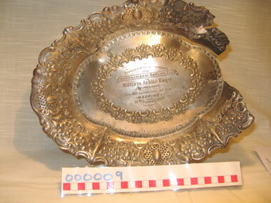 Warrnambool and District Historical Society Inc.
Domestic object - Serving dish, Late 19th century
... Taylor. It was recovered from the fire which destroyed the Hotel Mansions building in Warrnambool in 1929. This building was opened in 1890 as the Grand Ozone Coffee Palace (a temperance hotel). It was at the corner of Koroit and Kepler Streets. In 1891 the Coffee Palace was granted...Taylor. It was recovered from the fire which destroyed the Hotel Mansions building in Warrnambool in 1929. This building was opened in 1890 as the Grand Ozone Coffee Palace (a temperance hotel). It was at the corner of Koroit and Kepler Streets. In 1891 the Coffee Palace was granted ...This plate was presented in 1900 to a Warrnambool lawyer, William Ardlie, on the occasion of his marriage to Maud Taylor. It was recovered from the fire which destroyed the Hotel Mansions building in Warrnambool in 1929. This building was opened in 1890 as the Grand Ozone Coffee Palace (a temperance hotel). It was at the corner of Koroit and Kepler Streets. In 1891 the Coffee Palace was granted a wine licence and in 1895 it was re-named the Ozone Hotel. The building was closed in 1915 and re-opened in 1920 as the Hotel Mansions. In 1923 the Hotel Mansions became a fully-licensed hotel and in 1929 it was destroyed by fire. The present-day Hotel Warrnambool was built on the site. William Ardlie, the son of a pioneer Warrnambool settler, John Ardlie, began practising as a lawyer in Warrnambool in the mid 1860s and dominated the legal scene in Warrnambool, continuing on his practice until he was over 80. He and his second wife, Maud, were occupying an apartment in the Hotel Mansions when it was destroyed by fire and this plate is a relic of the fire. The Warrnambool Bowling Club which presented the plate to William Ardlie, was established early in the 1890s and William Ardlie was an enthusiastic supporter and one-time office bearer.This plate is of great significance as it was one of the few items that still exist that was recovered from the 1929 Hotel Mansions fire and its story contains so much of Warrnambool’s history with its connections to:- 1. The story of the Hotel Mansions, the grandest building ever erected in Warrnambool 2. The story of William Ardlie, a dominant figure in the legal world in Warrnambool for over 60 years 3. The story of the Warrnambool Bowls Club, still existing today. This is a silver plate with an oval base with an inside ring and a rim of scroll patterning. The recessed edges of the plate are highly ornamented with scrolls and flower patterning. Parts of the edge of the plate are missing and jagged as this plate has been in a major fire. On the base of the plate are three silver studs for the plate to rest on a surface. The fourth stud is missing. On the rim of the plate are two small projections, suggesting the plate originally had a handle. On the base of the plate is an inscription.‘Presented by the members of the Warrnambool Bowling Club to William Ardlie Esq.re (ex President) on the occasion of his WEDDING, 10th January 1900.’ grand ozone coffee palace/ozone hotel/ hotel mansions, warrnambool, william ardlie, warrnambool bowls club, history of warrnambool -
 Bendigo Military Museum
Photograph - Army Survey Regiment Open Day at Fortuna, Bendigo, 1990
... Grant Davis, civilian visitors. .2) - Photo, black & white, 1990. Photo Troop, WO2 Keith Fenton RE. UK Exchange. .3) - Photo, black & white, 1990. Aerotrig, SGT Bruce Hammond, civilian visitors. .4) - Photo, black & white, 1990. AUTOMAP 2 L to R: SPR Peter Smyth, LT Steve Hledik, SGT Martin Evans, MAJ Neil Taylor...Grant Davis, civilian visitors. .2) - Photo, black & white, 1990. Photo Troop, WO2 Keith Fenton RE. UK Exchange. .3) - Photo, black & white, 1990. Aerotrig, SGT Bruce Hammond, civilian visitors. .4) - Photo, black & white, 1990. AUTOMAP 2 L to R: SPR Peter Smyth, LT Steve Hledik, SGT Martin Evans, MAJ Neil Taylor ...These six photographs were taken at an Army Survey Regiment Open Day at Fortuna Villa, Bendigo on the 24th of February 1990. This occasion was one of several events held to commemorate the 75th anniversary of the formation of the Royal Australian Survey Corps. Although historical tours of Fortuna occurred on a regular basis, this was the first technical open day since 1972. The Royal Australian Survey Corps recognised that an Open Day was the best way for the local community in Bendigo to gain an insight into the unit’s important role as Defence’s map production agency, its technical equipment, and its economic importance to Bendigo. It also gave them an opportunity to tour through historic Fortuna Villa. This occasion is covered in more detail in page 143 of Valerie Lovejoy’s book 'Mapmakers of Fortuna – A history of the Army Survey Regiment’ ISBN: 0-646-42120-4. Refer to Item 6247.30P for more photos of the Open Day. These six photographs were taken at an Army Survey Regiment Open Day at Fortuna, Bendigo on the 24th of February 1990. The colour and black & white photographs were printed on photographic paper and are part of the Army Survey Regiment’s Collection. The photographs were scanned at 300 dpi. .1) - Photo, colour, 1990, AUTOMAP 2 L to R: SSGT Graham Johnston, SPR Grant Davis, civilian visitors. .2) - Photo, black & white, 1990. Photo Troop, WO2 Keith Fenton RE. UK Exchange. .3) - Photo, black & white, 1990. Aerotrig, SGT Bruce Hammond, civilian visitors. .4) - Photo, black & white, 1990. AUTOMAP 2 L to R: SPR Peter Smyth, LT Steve Hledik, SGT Martin Evans, MAJ Neil Taylor, Civilian visitors. .5) - black & white, Orthophoto Mapping, L to R: civilian visitors, SSGT Peter Imeson, civilian visitor, SGT Bob Garritty. .6) - black & white, Print Troop L to R: civilian visitors, SSGT Ian Nichols, CPL John ‘Flash’ Anderson..1P to .6P – there are no annotations.royal australian survey corps, army svy regt, rasvy, army survey regiment, fortuna, asr -
 Bendigo Military Museum
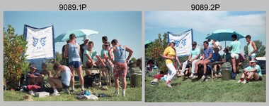
Photograph - Army Survey Regiment Inter-Squadron Athletics Competition - Set 2, Bendigo, 1990
... Background L to R: Paul Richards, Brian Collings, Ian ‘Rock’ Thistleton. .9) & .10) - Photo, colour, 1990, Peter Imerson. .11) - Photo, colour, 1990, Wheelbarrow Race, L to R: Steve Hansen, Noel ‘Nesty’ Coulthard, Stuart Thaxter. .12) - Photo, colour, 1990, Wheelbarrow Race, L to R: Ken ‘Sluggo’ Slater, Ray Redman, Steve Hansen, Noel ‘Nesty’ Coulthard, Stuart Thaxter, Steve Wegener, unidentified, Neil Taylor, Graham Ragless, Gary Warnest, Chris Wynn, Bill Jones, Marty Lyons, Rob Bogumil, Dave McLachlan. .13) - Photo, colour, 1990, Wheelbarrow Race, L to R: Ken ‘Sluggo’ Slater, Steve Hledik, Bob Coote, Steve Hansen, unidentified, Bill Jones, Neil Taylor. .14) - Photo, colour, 1990, Wheelbarrow Race, L to R: Marty Lyons, Rob Bogumil. .15) - Photo, colour, 1990, Wheelbarrow Race, L to R: Neil Taylor, Graham Ragless, Ray Redman, Steve Hansen. .16) - Photo, colour, 1990, Wheelbarrow Race, L to R: Bob Coote, Neil Taylor, Graham Ragless, Gary Warnest, Marty Lyons, Rob Bogumil, Dave McLachlan, Bill Jones. .17) - Photo, colour, 1990, Wheelbarrow Race, L to R: Bob Coote, Bill Jones. .18) - Photo, colour, 1990, Wheelbarrow Race, L to R: Gary Warnest, Terry Lord, Stuart Thaxter, Noel ‘Nesty’ Coulthard. .19) - Photo, colour, 1990, teams prepare for Tunnelball event. Andy Lucas at far right. .20) - Photo, colour, 1990, Carto Sqn Team Banner. At front L to R: unidentified, Steve Wegener. At rear L to R: Jodie Seath, Steve Wainwright. Grant...Background L to R: Paul Richards, Brian Collings, Ian ‘Rock’ Thistleton. .9) & .10) - Photo, colour, 1990, Peter Imerson. .11) - Photo, colour, 1990, Wheelbarrow Race, L to R: Steve Hansen, Noel ‘Nesty’ Coulthard, Stuart Thaxter. .12) - Photo, colour, 1990, Wheelbarrow Race, L to R: Ken ‘Sluggo’ Slater, Ray Redman, Steve Hansen, Noel ‘Nesty’ Coulthard, Stuart Thaxter, Steve Wegener, unidentified, Neil Taylor, Graham Ragless, Gary Warnest, Chris Wynn, Bill Jones, Marty Lyons, Rob Bogumil, Dave McLachlan. .13) - Photo, colour, 1990, Wheelbarrow Race, L to R: Ken ‘Sluggo’ Slater, Steve Hledik, Bob Coote, Steve Hansen, unidentified, Bill Jones, Neil Taylor. .14) - Photo, colour, 1990, Wheelbarrow Race, L to R: Marty Lyons, Rob Bogumil. .15) - Photo, colour, 1990, Wheelbarrow Race, L to R: Neil Taylor, Graham Ragless, Ray Redman, Steve Hansen. .16) - Photo, colour, 1990, Wheelbarrow Race, L to R: Bob Coote, Neil Taylor, Graham Ragless, Gary Warnest, Marty Lyons, Rob Bogumil, Dave McLachlan, Bill Jones. .17) - Photo, colour, 1990, Wheelbarrow Race, L to R: Bob Coote, Bill Jones. .18) - Photo, colour, 1990, Wheelbarrow Race, L to R: Gary Warnest, Terry Lord, Stuart Thaxter, Noel ‘Nesty’ Coulthard. .19) - Photo, colour, 1990, teams prepare for Tunnelball event. Andy Lucas at far right. .20) - Photo, colour, 1990, Carto Sqn Team Banner. At front L to R: unidentified, Steve Wegener. At rear L to R: Jodie Seath, Steve Wainwright. Grant ...This is a set of 30 photographs of an Army Survey Regiment inter-squadron athletics competition held at Epsom, Bendigo in 1990. Personnel from Headquarters, Air Survey, Cartographic and Lithographic Squadrons took part in traditional athletics events, wheelbarrow race, sack race, fireman’s carry and tug-of-war novelty events.’ Air Survey Squadron’s team was bolstered with members from Adelaide’s 4th Field Survey Squadron. Refer to items 9088.32P - Set 1 and 9090.31P -Set 3 for additional photos taken during the Athletics Event.This is a set of 30 photographs of an Army Survey Regiment inter-squadron athletics competition held at Bendigo in 1990. The photographs are on 35mm negative film and were scanned at 2400 dpi. They are part of the Army Survey Regiment’s Collection. .1) - Photo, colour, 1990, Air Survey Squadron HQ, L to R: John Shephard, unidentified, Noel McNamara - obscured, Tony Grivel – facing away, Bruce Hammond, Mark Lander, Andy Love, Chris ‘Charlie’ Brown, Doug Willis – facing away. .2) - Photo, colour, 1990, Air Survey Squadron HQ, L to R: Janette Dury-Lane, Chris ‘Charlie’ Brown, Peter Peterson, Paul Hopes, Mark Lander, Stuart Bowd, Noel Brinsmead. .3) - Photo, colour, 1990, Lithographic Squadron ‘brothers’ L to R: Peter Imerson, Trevor Osborne, Bob Coote, Rhys De Laine. .4) - Photo, colour, 1990, Lithographic Squadron ‘brothers’ L to R: Cameron Kelly, Scott Cameron, Steve Burke, Andrew Morrison-Evans. .5) - Photo, colour, 1990, Relay Race, foreground L to R: Laurie Justin, Peter Imeson. Background L to R: John Reid, Stuart Thaxter, Geoff Webb. .6) - Photo, colour, 1990, Relay Race, L to R: Terry King, Ian Fitzgerald. .7) - Photo, colour, 1990, Relay Race, Bob Coote. .8) - Photo, colour, 1990, officials conferring in foreground L to R: Ian Nelson, Fred Cowie, unidentified. Background L to R: Paul Richards, Brian Collings, Ian ‘Rock’ Thistleton. .9) & .10) - Photo, colour, 1990, Peter Imerson. .11) - Photo, colour, 1990, Wheelbarrow Race, L to R: Steve Hansen, Noel ‘Nesty’ Coulthard, Stuart Thaxter. .12) - Photo, colour, 1990, Wheelbarrow Race, L to R: Ken ‘Sluggo’ Slater, Ray Redman, Steve Hansen, Noel ‘Nesty’ Coulthard, Stuart Thaxter, Steve Wegener, unidentified, Neil Taylor, Graham Ragless, Gary Warnest, Chris Wynn, Bill Jones, Marty Lyons, Rob Bogumil, Dave McLachlan. .13) - Photo, colour, 1990, Wheelbarrow Race, L to R: Ken ‘Sluggo’ Slater, Steve Hledik, Bob Coote, Steve Hansen, unidentified, Bill Jones, Neil Taylor. .14) - Photo, colour, 1990, Wheelbarrow Race, L to R: Marty Lyons, Rob Bogumil. .15) - Photo, colour, 1990, Wheelbarrow Race, L to R: Neil Taylor, Graham Ragless, Ray Redman, Steve Hansen. .16) - Photo, colour, 1990, Wheelbarrow Race, L to R: Bob Coote, Neil Taylor, Graham Ragless, Gary Warnest, Marty Lyons, Rob Bogumil, Dave McLachlan, Bill Jones. .17) - Photo, colour, 1990, Wheelbarrow Race, L to R: Bob Coote, Bill Jones. .18) - Photo, colour, 1990, Wheelbarrow Race, L to R: Gary Warnest, Terry Lord, Stuart Thaxter, Noel ‘Nesty’ Coulthard. .19) - Photo, colour, 1990, teams prepare for Tunnelball event. Andy Lucas at far right. .20) - Photo, colour, 1990, Carto Sqn Team Banner. At front L to R: unidentified, Steve Wegener. At rear L to R: Jodie Seath, Steve Wainwright. Grant Davis at left of umbrella.in background. .21) - Photo, colour, 1990, Tunnelball. Left team L to R: Steve Hansen, unidentified (x4), Paul ‘Fluff’ Cheater, Wayne Rothwell. Centre team L to R: Noel ‘Macca’ McNamara – with medicine ball, Stuart Symonds, Neil ‘Ned’ Kelly, John Shephard, Allan Hancox, Bruce Hammond. Right team: all unidentified. .22) - Photo, colour, 1990, Tunnelball. Left team: Neil ‘Ned’ Kelly. Centre team L to R: unidentified, Peter Dillon, Greg Howell, Peter Breukel, Frank Lenane, Steve Egan, Darren ‘Barney’ Maher. Right team: Barry Hogan. .23) - Photo, colour, 1990, Tunnelball. Left team L to R: Frank Lenane, remainder unidentified. Right team L to R: Grant Davis – with medicine ball, Dan Cirsky, Bob Bright, Barry Hogan, Rick van der Bom. Spectators L to R: unidentified, Kevin ‘Chuck’ Berry, Chris Wynn. .24) - Photo, colour, 1990, Tunnelball, Litho/Air Survey Team front to back: Janet Murray, Paula (Golding) Brinsmead, remainder unidentified. .25) - Photo, colour, 1990, Tunnelball, Litho/Air Survey Team front to back: Janet Murray, Dawn Hoadley, Shona Hastie, Tracy Tillman. .26) - Photo, colour, 1990, Tunnelball, spectators L to R: unidentified, Brendan McKinless, Penny Knott, unidentified. Carto Team L to R: Cam Bramich, Sandy Winn, Jeanette Drury-Lane, Caroline (Wyatt) Evans, Del Madge, remainder unidentified. .27) - Photo, colour, 1990, Tunnelball, spectators L to R: Brendan McKinless Dawn Hoadley. Carto Team L to R: Cam Bramich, Sandy Winn, Jeanette Drury-Lane, remainder unidentified. Sue (Foote) Bourne – with medicine ball. .28) - Photo, colour, 1990, Tunnelball, spectators L to R: unidentified photographer, Brendan McKinless, Carto Team front to back: Raelene (Munting) Brodie, Jeanette Drury-Lane, Sandy Winn, unidentified, Sue (Foote) Bourne, Charmain McKean, Del Madge, Simone Rodgers – with medicine ball. .29) - Photo, colour, 1990, Tunnelball, Carto Team back row L to R: Sandy Winn, Cam Bramich, Jeanette Drury-Lane, Del Madge, Charmain McKean. Front row L to R: Sue (Foote) Bourne, Simone Rodgers – with medicine balls. .30) - Photo, colour, 1990, Women participants back row L to R: Sue (Foote) Bourne, unidentified, Sandy Winn, Nadine (Paul) Read, Simone Rodgers, Craig Kellet – in drag, Del Madge, Janet Murray, Charmain McKean, Caroline (Wyatt) Evans. Cam Bramich, Raelene (Munting) Brodie, Sherri (Dally) Burke. Front row L to R: Shona Hastie, Jo Otto, Paula (Golding) Brinsmead, Jodi Seath, Dawn Hoadley, Tracy Tillman. Penny Knott.No personnel are identified.royal australian survey corps, rasvy, army survey regiment, army svy regt, fortuna -
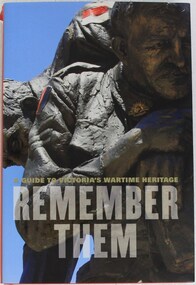 4th/19th Prince of Wales's Light Horse Regiment Unit History Room
Book, A Guide to Victoria's Wartime Heritage. Remember Them, 2009
... This comprehensive survey of Victoria's memorial landscape will be an invaluable starting point for teachers and students who are exploring its impact in their community" John Taylor Chairman, Shrine of Remembrance war memorials victoria history war memorials victoria history ISBN 978 1 74066 840 8 Hardcover book of 308 pages A Guide to Victoria's Wartime Heritage. Remember Them Book Book Hardie Grant ..."Australia's involvement in war and peacekeeping operations has touched almost every town, large and small, in Victoria. This comprehensive survey of Victoria's memorial landscape will be an invaluable starting point for teachers and students who are exploring its impact in their community" John Taylor Chairman, Shrine of RemembranceHardcover book of 308 pagesISBN 978 1 74066 840 8war memorials, victoria, history, war memorials, victoria, history -
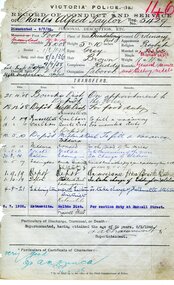 Victoria Police Museum
Record of Conduct and Service (Charles Alfred Taylor)
... Victoria Police service: Joined: 28/10/1908; Granted leave without pay: 5/05/1917; Re-joined: 1/10/1919; Retired: 8/02/1946; Highest rank: Inspector WW1 service: Enlisted: 10 May 1917; Highest rank: Corporal; Regiment: 38th Battalion; Fate: Returned to Australia 4 July 1919; Medals: 1914-1915 Star, British War and Victory medals world war 1, 1914-1918; victoria police; taylor, charles alfred 5429 Official document Record of Conduct and Service (Charles Alfred Taylor) ...When the First World War broke out, Australian men from all backgrounds and professions were called to serve their country. Members of the Victorian Police force were some of the first to answer the call with twenty men joining the first convoy of soldiers who left Australian shores in October 1914. Over the course of four long years, one hundred and thirty-eight Victorian Police enlisted from stations across the state. Of these, twenty-seven lost their lives. Whilst the fate of each man was different, a deep commitment to protecting and serving the public was common to all. Victoria Police service: Joined: 28/10/1908; Granted leave without pay: 5/05/1917; Re-joined: 1/10/1919; Retired: 8/02/1946; Highest rank: Inspector WW1 service: Enlisted: 10 May 1917; Highest rank: Corporal; Regiment: 38th Battalion; Fate: Returned to Australia 4 July 1919; Medals: 1914-1915 Star, British War and Victory medalsOfficial documentworld war 1, 1914-1918; victoria police; taylor, charles alfred 5429 -
 Federation University Historical Collection
Book, information Services Annual Report 2007
... Grant...Carolyn Bray...Sue Taylor...Barker Library (top floor) Mount Helen goldfields University of Ballarat is a predecessor of Federation University University of Ballarat Information Services Annual Report Leeanne Pitman tim o'doherty Daniel Wilson Matthew Elevy Jeremey Egan Hugh Townsend Historical Collection Art Collection Clare Gervasoni John Dixon Greg Eames David Edwards Jason Rankin Leigh Vincent Sue McPhan Peggy Hsu Carmel Grant Carolyn Bray Sue Taylor Jill Nicholls Gaida Stevens Julie Lasinger Tracey Wilson Ian Wright Lloyd Stinton Clair McCready Steve Pallett Kerry Matheson Kerry Wilson Angela Thomas Marilyn Jeffs Anita Gurton Cheryl Claridge Nancy Lange Karen Pruis Annette Bauska Ken Clements Zig Plavina A4 sized book containing the information Services Annual Report 2007. ...University of Ballarat is a predecessor of Federation UniversityA4 sized book containing the information Services Annual Report 2007. Cover has University of Ballarat logo with Maroon, yellow and blue colour patches.university of ballarat, information services, annual report, leeanne pitman, tim o'doherty, daniel wilson, matthew elevy, jeremey egan, hugh townsend, historical collection, art collection, clare gervasoni, john dixon, greg eames, david edwards, jason rankin, leigh vincent, sue mcphan, peggy hsu, carmel grant, carolyn bray, sue taylor, jill nicholls, gaida stevens, julie lasinger, tracey wilson, ian wright, lloyd stinton, clair mccready, steve pallett, kerry matheson, kerry wilson, angela thomas, marilyn jeffs, anita gurton, cheryl claridge, nancy lange, karen pruis, annette bauska, ken clements, zig plavina -
Federation University Historical Collection
Document - Documents, Australian Government Covid-19 Vaccination Booster Dose information, 19/08/2020
... By 18 May, this had increased to 12 cases, and on that day it was revealed that a delivery driver had tested positive, prompting the closing for cleaning of 12 more McDonald's locations: Melton East, Laverton North, Yallambie, Taylors Lakes, Campbellfield, Sunbury, Hoppers Crossing, Riverdale Village, Sandown, Calder Highway Northbound/Outbound, Calder Highway Southbound/Inbound, and BP Rockbank Service Centre Outbound. On 15 May, South Australia became the second jurisdiction, after the ACT, to be free of any active cases, however on 26 May, a woman returning from overseas who was granted exemption into South Australia from her hotel quarantine in Victoria tested positive for COVID-19. ...By 18 May, this had increased to 12 cases, and on that day it was revealed that a delivery driver had tested positive, prompting the closing for cleaning of 12 more McDonald's locations: Melton East, Laverton North, Yallambie, Taylors Lakes, Campbellfield, Sunbury, Hoppers Crossing, Riverdale Village, Sandown, Calder Highway Northbound/Outbound, Calder Highway Southbound/Inbound, and BP Rockbank Service Centre Outbound. On 15 May, South Australia became the second jurisdiction, after the ACT, to be free of any active cases, however on 26 May, a woman returning from overseas who was granted exemption into South Australia from her hotel quarantine in Victoria tested positive for COVID-19. ...On 12 January, the World Health Organization (WHO) confirmed that a novel coronavirus was the cause of a respiratory illness in a cluster of people in Wuhan City, Hubei Province, China, who had initially come to the attention of the WHO on 31 December 2019. On 3 March, the Reserve Bank of Australia became the first central bank to cut interest rates in response to the outbreak. Official interest rates were cut by 0.25% (25 base points) to a record low of 0.5%. On 12 March, the Federal Government announced a A$17.6 billion stimulus package, the first since the 2008 GFC. he package consists of multiple parts, a one-off A$750 payment to around 6.5 million welfare recipients as early as 31 March 2020, small business assistance with 700,000 grants up to $25,000 and a 50% wage subsidy for 120,000 apprenticies or trainees for up to 9 months, 1 billion to support economically impacted sectors, regions and communities, and $700 million to increase tax write off and $3.2 billion to support short-term small and medium-sized business investment. On 16 March, Premier Dan Andrews and Minister for Health Jenny Mikakos declared a state of emergency for Victoria for at least four weeks. On 19 March, the Reserve Bank again cut interest rates by a further 0.25% to 0.25%, the lowest in Australian history. On 22 March, the government announced a second stimulus package of A$66bn, increasing the amount of total financial package offered to A$89bn. This included several new measures like doubling income support for individuals on Jobseeker's allowance, granting A$100,000 to small and medium-sized businesses and A$715 million to Australian airports and airlines. It also allowed individuals affected by the outbreak to access up to A$10,000 of their superannuation during 2019–2020 and also being able to take an additional same amount for the next year. on the same day Victorian Premier Daniel Andrews announced on 22 March that the state will bring the school holiday forwards to 24 March from 27 March. On 30 March, the Australian Federal Government announced a $130 billion "JobKeeper" wage subsidy program offering to pay employers up to $1500 a fortnight per full-time, part-time or casual employee that has worked for that business for over a year. For a business to be eligible, they must have lost 30% of turnover after 1 March of annual revenue up to and including $1 billion. For businesses with a revenue of over $1 billion, turnover must have decreased by 50%. Businesses are then required by law to pay the subsidy to their staff, in lieu of their usual wages. This response came after the enormous job losses seen just a week prior when an estimated 1 million Australians lost their jobs. This massive loss in jobs caused the myGov website to crash and lines out of Centrelink offices to run hundreds of metres long.The program was backdated to 1 March, to aim at reemploying the many people who had just lost their jobs in the weeks before. Businesses would receive the JobKeeper subsidy for six months. On 2 April, the number of cases in Victoria exceeded 1,000, including over 100 healthcare workers. On 5 April, New South Wales Police launched a criminal investigation into whether the operator of Ruby Princess, Carnival Australia, broke the Biosecurity Act 2015 (Cwth) and New South Wales state laws, by deliberately concealing COVID-19 cases. On 6 April, the Department of Health revealed that 2,432 people recovered from the infection as the federal government started reporting recovery statistics. This is more than a third from the official number reported so far, Deputy Chief Medical Officer Professor Paul Kelly stating, "I think it is important. Firstly it really reinforces that message, which is a true one, that most people who get this disease do recover”. The day before, at 3pm, it was announced that 2,315 of the 5,687 confirmed coronavirus cases had recovered. May 2020 - An outbreak in Victoria at a meatworks that was later revealed to be Cedar Meats was announced on 02 May with eight cases. By 8 May, the cluster of cases linked to Cedar Meats in Victoria was 71, consisting of at least 57 workers and 13 close contacts, including a nurse, aged care worker and high school student. The number had increased to 75 by 9 May, 88 by 13 May, and 90 by 14 May. On 9 May, two Victorian cases were announced to be related to McDonald's Fawkner. By 18 May, this had increased to 12 cases, and on that day it was revealed that a delivery driver had tested positive, prompting the closing for cleaning of 12 more McDonald's locations: Melton East, Laverton North, Yallambie, Taylors Lakes, Campbellfield, Sunbury, Hoppers Crossing, Riverdale Village, Sandown, Calder Highway Northbound/Outbound, Calder Highway Southbound/Inbound, and BP Rockbank Service Centre Outbound. On 15 May, South Australia became the second jurisdiction, after the ACT, to be free of any active cases, however on 26 May, a woman returning from overseas who was granted exemption into South Australia from her hotel quarantine in Victoria tested positive for COVID-19. This was the first new case in 19 days for the state.[101] On 4 June, it was announced that the woman had recovered and the state was free of any active cases once again.[102] On 17 May, Victoria announced two further business sites had been shut down due to a suspected case at each. Domino's Pizza in Fairfield has been shut for two weeks, and mattress manufacturer The Comfort Group in Deer Park was closed from Friday 15 May to at least Wednesday 20 May. On 6 June, both New South Wales and Victoria reported no new cases for the previous 24 hours, with only Queensland and Western Australia reporting one new case each, the lowest national total since February. Western Australia also announced two old cases. However, the new case in Queensland was linked to the Rydges on Swanston cluster in Melbourne when a man who travelled from Melbourne to Brisbane on Virgin flight VA313 on 1 June tested positive.An A4 printed document persented to those who received a Covid19 Vaccination boostercovid-19, corona virus, pandemic, social distancing, lock down, vaccine, vaccine booster -
 Federation University Historical Collection
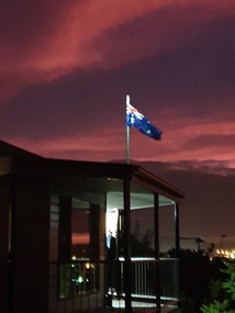
Photograph - Colour, ANZAC Dawn Remembrance During the Covid-19 Pandemic, 2020, 25/04/2020
... By 18 May, this had increased to 12 cases, and on that day it was revealed that a delivery driver had tested positive, prompting the closing for cleaning of 12 more McDonald's locations: Melton East, Laverton North, Yallambie, Taylors Lakes, Campbellfield, Sunbury, Hoppers Crossing, Riverdale Village, Sandown, Calder Highway Northbound/Outbound, Calder Highway Southbound/Inbound, and BP Rockbank Service Centre Outbound. On 15 May, South Australia became the second jurisdiction, after the ACT, to be free of any active cases, however on 26 May, a woman returning from overseas who was granted exemption into South Australia from her hotel quarantine in Victoria tested positive for COVID-19. ...By 18 May, this had increased to 12 cases, and on that day it was revealed that a delivery driver had tested positive, prompting the closing for cleaning of 12 more McDonald's locations: Melton East, Laverton North, Yallambie, Taylors Lakes, Campbellfield, Sunbury, Hoppers Crossing, Riverdale Village, Sandown, Calder Highway Northbound/Outbound, Calder Highway Southbound/Inbound, and BP Rockbank Service Centre Outbound. On 15 May, South Australia became the second jurisdiction, after the ACT, to be free of any active cases, however on 26 May, a woman returning from overseas who was granted exemption into South Australia from her hotel quarantine in Victoria tested positive for COVID-19. ...On 12 January, the World Health Organization (WHO) confirmed that a novel coronavirus was the cause of a respiratory illness in a cluster of people in Wuhan City, Hubei Province, China, who had initially come to the attention of the WHO on 31 December 2019. On 3 March, the Reserve Bank of Australia became the first central bank to cut interest rates in response to the outbreak. Official interest rates were cut by 0.25% (25 base points) to a record low of 0.5%. On 12 March, the Federal Government announced a A$17.6 billion stimulus package, the first since the 2008 GFC. he package consists of multiple parts, a one-off A$750 payment to around 6.5 million welfare recipients as early as 31 March 2020, small business assistance with 700,000 grants up to $25,000 and a 50% wage subsidy for 120,000 apprenticies or trainees for up to 9 months, 1 billion to support economically impacted sectors, regions and communities, and $700 million to increase tax write off and $3.2 billion to support short-term small and medium-sized business investment. On 16 March, Premier Dan Andrews and Minister for Health Jenny Mikakos declared a state of emergency for Victoria for at least four weeks. On 19 March, the Reserve Bank again cut interest rates by a further 0.25% to 0.25%, the lowest in Australian history. On 22 March, the government announced a second stimulus package of A$66bn, increasing the amount of total financial package offered to A$89bn. This included several new measures like doubling income support for individuals on Jobseeker's allowance, granting A$100,000 to small and medium-sized businesses and A$715 million to Australian airports and airlines. It also allowed individuals affected by the outbreak to access up to A$10,000 of their superannuation during 2019–2020 and also being able to take an additional same amount for the next year. on the same day Victorian Premier Daniel Andrews announced on 22 March that the state will bring the school holiday forwards to 24 March from 27 March. On 30 March, the Australian Federal Government announced a $130 billion "JobKeeper" wage subsidy program offering to pay employers up to $1500 a fortnight per full-time, part-time or casual employee that has worked for that business for over a year. For a business to be eligible, they must have lost 30% of turnover after 1 March of annual revenue up to and including $1 billion. For businesses with a revenue of over $1 billion, turnover must have decreased by 50%. Businesses are then required by law to pay the subsidy to their staff, in lieu of their usual wages. This response came after the enormous job losses seen just a week prior when an estimated 1 million Australians lost their jobs. This massive loss in jobs caused the myGov website to crash and lines out of Centrelink offices to run hundreds of metres long.The program was backdated to 1 March, to aim at reemploying the many people who had just lost their jobs in the weeks before. Businesses would receive the JobKeeper subsidy for six months. On 2 April, the number of cases in Victoria exceeded 1,000, including over 100 healthcare workers. On 5 April, New South Wales Police launched a criminal investigation into whether the operator of Ruby Princess, Carnival Australia, broke the Biosecurity Act 2015 (Cwth) and New South Wales state laws, by deliberately concealing COVID-19 cases. On 6 April, the Department of Health revealed that 2,432 people recovered from the infection as the federal government started reporting recovery statistics. This is more than a third from the official number reported so far, Deputy Chief Medical Officer Professor Paul Kelly stating, "I think it is important. Firstly it really reinforces that message, which is a true one, that most people who get this disease do recover”. The day before, at 3pm, it was announced that 2,315 of the 5,687 confirmed coronavirus cases had recovered. May 2020 - An outbreak in Victoria at a meatworks that was later revealed to be Cedar Meats was announced on 02 May with eight cases. By 8 May, the cluster of cases linked to Cedar Meats in Victoria was 71, consisting of at least 57 workers and 13 close contacts, including a nurse, aged care worker and high school student. The number had increased to 75 by 9 May, 88 by 13 May, and 90 by 14 May. On 9 May, two Victorian cases were announced to be related to McDonald's Fawkner. By 18 May, this had increased to 12 cases, and on that day it was revealed that a delivery driver had tested positive, prompting the closing for cleaning of 12 more McDonald's locations: Melton East, Laverton North, Yallambie, Taylors Lakes, Campbellfield, Sunbury, Hoppers Crossing, Riverdale Village, Sandown, Calder Highway Northbound/Outbound, Calder Highway Southbound/Inbound, and BP Rockbank Service Centre Outbound. On 15 May, South Australia became the second jurisdiction, after the ACT, to be free of any active cases, however on 26 May, a woman returning from overseas who was granted exemption into South Australia from her hotel quarantine in Victoria tested positive for COVID-19. This was the first new case in 19 days for the state.[101] On 4 June, it was announced that the woman had recovered and the state was free of any active cases once again.[102] On 17 May, Victoria announced two further business sites had been shut down due to a suspected case at each. Domino's Pizza in Fairfield has been shut for two weeks, and mattress manufacturer The Comfort Group in Deer Park was closed from Friday 15 May to at least Wednesday 20 May. On 6 June, both New South Wales and Victoria reported no new cases for the previous 24 hours, with only Queensland and Western Australia reporting one new case each, the lowest national total since February. Western Australia also announced two old cases. However, the new case in Queensland was linked to the Rydges on Swanston cluster in Melbourne when a man who travelled from Melbourne to Brisbane on Virgin flight VA313 on 1 June tested positive.Colour photographs of an ANZAC dawn remembrance from Armstrong Street South, Ballarat looking East towards Mount Warrenheip. Due to the Covid-19 Pandemic and associated social distancing requirements regular ANZAC Day services and marches could not be held. People were encouraged to remember from their driveways at dawn on 25 April 2020. covid-19, corona virus, pandemic, social distancing, anzac day driveway remembrance, dawn, australian flag, mount warrenheip -
 Federation University Historical Collection
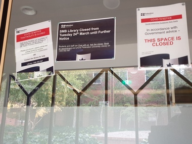
Photograph - Colour, Federation University SMB Campus library Covid 19 Lockdown Notices, 2020, 23/04/2020
... By 18 May, this had increased to 12 cases, and on that day it was revealed that a delivery driver had tested positive, prompting the closing for cleaning of 12 more McDonald's locations: Melton East, Laverton North, Yallambie, Taylors Lakes, Campbellfield, Sunbury, Hoppers Crossing, Riverdale Village, Sandown, Calder Highway Northbound/Outbound, Calder Highway Southbound/Inbound, and BP Rockbank Service Centre Outbound. On 15 May, South Australia became the second jurisdiction, after the ACT, to be free of any active cases, however on 26 May, a woman returning from overseas who was granted exemption into South Australia from her hotel quarantine in Victoria tested positive for COVID-19. ...By 18 May, this had increased to 12 cases, and on that day it was revealed that a delivery driver had tested positive, prompting the closing for cleaning of 12 more McDonald's locations: Melton East, Laverton North, Yallambie, Taylors Lakes, Campbellfield, Sunbury, Hoppers Crossing, Riverdale Village, Sandown, Calder Highway Northbound/Outbound, Calder Highway Southbound/Inbound, and BP Rockbank Service Centre Outbound. On 15 May, South Australia became the second jurisdiction, after the ACT, to be free of any active cases, however on 26 May, a woman returning from overseas who was granted exemption into South Australia from her hotel quarantine in Victoria tested positive for COVID-19. ...On 12 January, the World Health Organization (WHO) confirmed that a novel coronavirus was the cause of a respiratory illness in a cluster of people in Wuhan City, Hubei Province, China, who had initially come to the attention of the WHO on 31 December 2019. On 3 March, the Reserve Bank of Australia became the first central bank to cut interest rates in response to the outbreak. Official interest rates were cut by 0.25% (25 base points) to a record low of 0.5%. On 12 March, the Federal Government announced a A$17.6 billion stimulus package, the first since the 2008 GFC. he package consists of multiple parts, a one-off A$750 payment to around 6.5 million welfare recipients as early as 31 March 2020, small business assistance with 700,000 grants up to $25,000 and a 50% wage subsidy for 120,000 apprenticies or trainees for up to 9 months, 1 billion to support economically impacted sectors, regions and communities, and $700 million to increase tax write off and $3.2 billion to support short-term small and medium-sized business investment. On 16 March, Premier Dan Andrews and Minister for Health Jenny Mikakos declared a state of emergency for Victoria for at least four weeks. On 19 March, the Reserve Bank again cut interest rates by a further 0.25% to 0.25%, the lowest in Australian history. On 22 March, the government announced a second stimulus package of A$66bn, increasing the amount of total financial package offered to A$89bn. This included several new measures like doubling income support for individuals on Jobseeker's allowance, granting A$100,000 to small and medium-sized businesses and A$715 million to Australian airports and airlines. It also allowed individuals affected by the outbreak to access up to A$10,000 of their superannuation during 2019–2020 and also being able to take an additional same amount for the next year. on the same day Victorian Premier Daniel Andrews announced on 22 March that the state will bring the school holiday forwards to 24 March from 27 March. On 30 March, the Australian Federal Government announced a $130 billion "JobKeeper" wage subsidy program offering to pay employers up to $1500 a fortnight per full-time, part-time or casual employee that has worked for that business for over a year. For a business to be eligible, they must have lost 30% of turnover after 1 March of annual revenue up to and including $1 billion. For businesses with a revenue of over $1 billion, turnover must have decreased by 50%. Businesses are then required by law to pay the subsidy to their staff, in lieu of their usual wages. This response came after the enormous job losses seen just a week prior when an estimated 1 million Australians lost their jobs. This massive loss in jobs caused the myGov website to crash and lines out of Centrelink offices to run hundreds of metres long.The program was backdated to 1 March, to aim at reemploying the many people who had just lost their jobs in the weeks before. Businesses would receive the JobKeeper subsidy for six months. On 2 April, the number of cases in Victoria exceeded 1,000, including over 100 healthcare workers. On 5 April, New South Wales Police launched a criminal investigation into whether the operator of Ruby Princess, Carnival Australia, broke the Biosecurity Act 2015 (Cwth) and New South Wales state laws, by deliberately concealing COVID-19 cases. On 6 April, the Department of Health revealed that 2,432 people recovered from the infection as the federal government started reporting recovery statistics. This is more than a third from the official number reported so far, Deputy Chief Medical Officer Professor Paul Kelly stating, "I think it is important. Firstly it really reinforces that message, which is a true one, that most people who get this disease do recover”. The day before, at 3pm, it was announced that 2,315 of the 5,687 confirmed coronavirus cases had recovered. May 2020 - An outbreak in Victoria at a meatworks that was later revealed to be Cedar Meats was announced on 02 May with eight cases. By 8 May, the cluster of cases linked to Cedar Meats in Victoria was 71, consisting of at least 57 workers and 13 close contacts, including a nurse, aged care worker and high school student. The number had increased to 75 by 9 May, 88 by 13 May, and 90 by 14 May. On 9 May, two Victorian cases were announced to be related to McDonald's Fawkner. By 18 May, this had increased to 12 cases, and on that day it was revealed that a delivery driver had tested positive, prompting the closing for cleaning of 12 more McDonald's locations: Melton East, Laverton North, Yallambie, Taylors Lakes, Campbellfield, Sunbury, Hoppers Crossing, Riverdale Village, Sandown, Calder Highway Northbound/Outbound, Calder Highway Southbound/Inbound, and BP Rockbank Service Centre Outbound. On 15 May, South Australia became the second jurisdiction, after the ACT, to be free of any active cases, however on 26 May, a woman returning from overseas who was granted exemption into South Australia from her hotel quarantine in Victoria tested positive for COVID-19. This was the first new case in 19 days for the state.[101] On 4 June, it was announced that the woman had recovered and the state was free of any active cases once again.[102] On 17 May, Victoria announced two further business sites had been shut down due to a suspected case at each. Domino's Pizza in Fairfield has been shut for two weeks, and mattress manufacturer The Comfort Group in Deer Park was closed from Friday 15 May to at least Wednesday 20 May. On 6 June, both New South Wales and Victoria reported no new cases for the previous 24 hours, with only Queensland and Western Australia reporting one new case each, the lowest national total since February. Western Australia also announced two old cases. However, the new case in Queensland was linked to the Rydges on Swanston cluster in Melbourne when a man who travelled from Melbourne to Brisbane on Virgin flight VA313 on 1 June tested positive.Colour photographs of closure signs on the E.J Tippett Library due to the Covid-19 Pandemic and associated lock down and social distancing requirements.covid-19, corona virus, pandemic, social distancing, ballarat school of mines, e.j. tippett library, lock down -
 Federation University Historical Collection
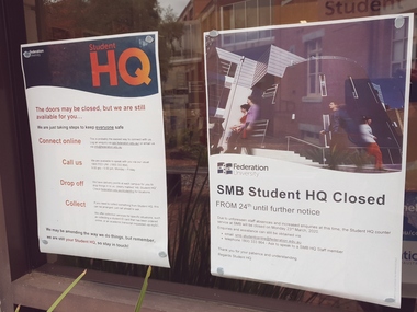
Photograph - Colour, Federation University SMB Campus Student HQ Covid 19 Closure Notices, 2020, 23/04/2020
... By 18 May, this had increased to 12 cases, and on that day it was revealed that a delivery driver had tested positive, prompting the closing for cleaning of 12 more McDonald's locations: Melton East, Laverton North, Yallambie, Taylors Lakes, Campbellfield, Sunbury, Hoppers Crossing, Riverdale Village, Sandown, Calder Highway Northbound/Outbound, Calder Highway Southbound/Inbound, and BP Rockbank Service Centre Outbound. On 15 May, South Australia became the second jurisdiction, after the ACT, to be free of any active cases, however on 26 May, a woman returning from overseas who was granted exemption into South Australia from her hotel quarantine in Victoria tested positive for COVID-19. ...By 18 May, this had increased to 12 cases, and on that day it was revealed that a delivery driver had tested positive, prompting the closing for cleaning of 12 more McDonald's locations: Melton East, Laverton North, Yallambie, Taylors Lakes, Campbellfield, Sunbury, Hoppers Crossing, Riverdale Village, Sandown, Calder Highway Northbound/Outbound, Calder Highway Southbound/Inbound, and BP Rockbank Service Centre Outbound. On 15 May, South Australia became the second jurisdiction, after the ACT, to be free of any active cases, however on 26 May, a woman returning from overseas who was granted exemption into South Australia from her hotel quarantine in Victoria tested positive for COVID-19. ...On 12 January, the World Health Organization (WHO) confirmed that a novel coronavirus was the cause of a respiratory illness in a cluster of people in Wuhan City, Hubei Province, China, who had initially come to the attention of the WHO on 31 December 2019. On 3 March, the Reserve Bank of Australia became the first central bank to cut interest rates in response to the outbreak. Official interest rates were cut by 0.25% (25 base points) to a record low of 0.5%. On 12 March, the Federal Government announced a A$17.6 billion stimulus package, the first since the 2008 GFC. he package consists of multiple parts, a one-off A$750 payment to around 6.5 million welfare recipients as early as 31 March 2020, small business assistance with 700,000 grants up to $25,000 and a 50% wage subsidy for 120,000 apprenticies or trainees for up to 9 months, 1 billion to support economically impacted sectors, regions and communities, and $700 million to increase tax write off and $3.2 billion to support short-term small and medium-sized business investment. On 16 March, Premier Dan Andrews and Minister for Health Jenny Mikakos declared a state of emergency for Victoria for at least four weeks. On 19 March, the Reserve Bank again cut interest rates by a further 0.25% to 0.25%, the lowest in Australian history. On 22 March, the government announced a second stimulus package of A$66bn, increasing the amount of total financial package offered to A$89bn. This included several new measures like doubling income support for individuals on Jobseeker's allowance, granting A$100,000 to small and medium-sized businesses and A$715 million to Australian airports and airlines. It also allowed individuals affected by the outbreak to access up to A$10,000 of their superannuation during 2019–2020 and also being able to take an additional same amount for the next year. on the same day Victorian Premier Daniel Andrews announced on 22 March that the state will bring the school holiday forwards to 24 March from 27 March. On 30 March, the Australian Federal Government announced a $130 billion "JobKeeper" wage subsidy program offering to pay employers up to $1500 a fortnight per full-time, part-time or casual employee that has worked for that business for over a year. For a business to be eligible, they must have lost 30% of turnover after 1 March of annual revenue up to and including $1 billion. For businesses with a revenue of over $1 billion, turnover must have decreased by 50%. Businesses are then required by law to pay the subsidy to their staff, in lieu of their usual wages. This response came after the enormous job losses seen just a week prior when an estimated 1 million Australians lost their jobs. This massive loss in jobs caused the myGov website to crash and lines out of Centrelink offices to run hundreds of metres long.The program was backdated to 1 March, to aim at reemploying the many people who had just lost their jobs in the weeks before. Businesses would receive the JobKeeper subsidy for six months. On 2 April, the number of cases in Victoria exceeded 1,000, including over 100 healthcare workers. On 5 April, New South Wales Police launched a criminal investigation into whether the operator of Ruby Princess, Carnival Australia, broke the Biosecurity Act 2015 (Cwth) and New South Wales state laws, by deliberately concealing COVID-19 cases. On 6 April, the Department of Health revealed that 2,432 people recovered from the infection as the federal government started reporting recovery statistics. This is more than a third from the official number reported so far, Deputy Chief Medical Officer Professor Paul Kelly stating, "I think it is important. Firstly it really reinforces that message, which is a true one, that most people who get this disease do recover”. The day before, at 3pm, it was announced that 2,315 of the 5,687 confirmed coronavirus cases had recovered. May 2020 - An outbreak in Victoria at a meatworks that was later revealed to be Cedar Meats was announced on 02 May with eight cases. By 8 May, the cluster of cases linked to Cedar Meats in Victoria was 71, consisting of at least 57 workers and 13 close contacts, including a nurse, aged care worker and high school student. The number had increased to 75 by 9 May, 88 by 13 May, and 90 by 14 May. On 9 May, two Victorian cases were announced to be related to McDonald's Fawkner. By 18 May, this had increased to 12 cases, and on that day it was revealed that a delivery driver had tested positive, prompting the closing for cleaning of 12 more McDonald's locations: Melton East, Laverton North, Yallambie, Taylors Lakes, Campbellfield, Sunbury, Hoppers Crossing, Riverdale Village, Sandown, Calder Highway Northbound/Outbound, Calder Highway Southbound/Inbound, and BP Rockbank Service Centre Outbound. On 15 May, South Australia became the second jurisdiction, after the ACT, to be free of any active cases, however on 26 May, a woman returning from overseas who was granted exemption into South Australia from her hotel quarantine in Victoria tested positive for COVID-19. This was the first new case in 19 days for the state.[101] On 4 June, it was announced that the woman had recovered and the state was free of any active cases once again.[102] On 17 May, Victoria announced two further business sites had been shut down due to a suspected case at each. Domino's Pizza in Fairfield has been shut for two weeks, and mattress manufacturer The Comfort Group in Deer Park was closed from Friday 15 May to at least Wednesday 20 May. On 6 June, both New South Wales and Victoria reported no new cases for the previous 24 hours, with only Queensland and Western Australia reporting one new case each, the lowest national total since February. Western Australia also announced two old cases. However, the new case in Queensland was linked to the Rydges on Swanston cluster in Melbourne when a man who travelled from Melbourne to Brisbane on Virgin flight VA313 on 1 June tested positive.Colour photographs of closure signs on the E.J Tippett Library due to the Covid-19 Pandemic and associated lock down and social distancing requirements.covid-19, corona virus, pandemic, social distancing, ballarat school of mines, e.j. tippett library, lock down -
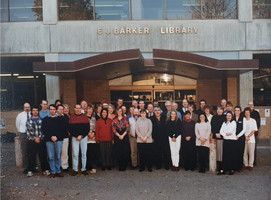 Federation University Historical Collection
Photograph - Photograph - Colour, E.J. Barker Librarians and Staff, c1995, c1995
... taylor...jenny leviston...kerry wilson...jill nicholls...rose counsel...carol wren...jacqui greenbank...noemi mckinnon...carmel grant...Barker Library (top floor) Mount Helen goldfields mt helen library e.j. barker library librarians gerry anderson kevin jewell bill hitchins david edwards alan brady lance duncan lee-anne pitman library suellen crouch debbie ford sue taylor jenny leviston kerry wilson jill nicholls rose counsel carol wren jacqui greenbank noemi mckinnon carmel grant liz hartman natalie radomski jan mccallum helen wiseman lloyd stinton arno besse andrew segrott garry wood ian lovejoy tim o'doherty mike gustus trevor day john stojanovski jeff dowsley herman ? ...Colour photograph of E.J. Barker Librarians and Staff outside the library on Mt Helen campus.mt helen library, e.j. barker library, librarians, gerry anderson, kevin jewell, bill hitchins, david edwards, alan brady, lance duncan, lee-anne pitman, library, suellen crouch, debbie ford, sue taylor, jenny leviston, kerry wilson, jill nicholls, rose counsel, carol wren, jacqui greenbank, noemi mckinnon, carmel grant, liz hartman, natalie radomski, jan mccallum, helen wiseman, lloyd stinton, arno besse, andrew segrott, garry wood, ian lovejoy, tim o'doherty, mike gustus, trevor day, john stojanovski, jeff dowsley, herman ?, andrew shiells, bill casey, jason rankin, chris andrews, jo ford, julie lasinger, narelle lamb, john fogarty -
 Federation University Historical Collection
Photographs - black and white, Ballarat College of Advanced Education: 1st Year Applied Science Students, 1983, 1983
... grant...humphries, robert...hynd,geraldine...jakubans, linda...jarecki, ted...jeffreys, andrew...johns, alvin...kirkpatrick, kaye...laidlaw, gary...lazarus, peter...lean, rohan...long, paul...markby, craig...mcdonald, peter...mceuna, timothy...mcinnes, gregory...mckay, james...nicholson, scott...o'connor, paul...owen, janette...owen, michael...pear, zlatko...picorrillo, john...pilkington, john...potter, steven...prendergast, maurice...roberts, barry...ryan, marie...schwarz, peter...seeary, adrian...shiells, jane...stevenson, michael...tan, simon...taylor...e/f guiseppe flanagan, denise ford, gary foster, gary fowler, anthony fullarton, david gore, brendan gorell, brett gowers, alan grinham, wayne hall, richard harrison, francis hartmann, mark hay, theresa hovard,stephen hoy, terrance hull, grant humphries, robert hynd,geraldine jakubans, linda jarecki, ted jeffreys, andrew johns, alvin kirkpatrick, kaye laidlaw, gary lazarus, peter lean, rohan long, paul markby, craig mcdonald, peter mceuna, timothy mcinnes, gregory mckay, james nicholson, scott o'connor, paul owen, janette owen, michael pear, zlatko picorrillo, john pilkington, john potter, steven prendergast, maurice roberts, barry ryan, marie schwarz, peter seeary, adrian shiells, jane stevenson, michael tan, simon taylor, catherine turkuile, marianne thomas, rosemarie twyford, keith vorstenbosch, mark walker, paul ward, jennifer warner, gary wheeler, stuart winter, anthony wood, mark yee, arthur zentgraf, mark bowie, ? ...Individual images of students in 1st Year Applied Science Course. The names of the student is written under the photo - in alphabetical order. Some spaces have no photo. Some names have been crossed out. In total there are 91 names (55 on one and 36 on the other). Of this number there are only 16 girls in the course for this year.Two beige cards with small black and white photographs - photographer's proofsName of student under photo - alphabetical orderapplied science, 1st year, barker, alison, baxter, mark, beamish, lisa, blake, linda, bodon, stephen, brown, rodney, byron, dean, campbell, noreen, cesnik, frank, clark, geoffrey, clarke, peter, coffey, damien, daniel, michelle, desnoy,gary, de vries, peter, drake, peter, duthie, barry, elkin, gary, ? e/f guiseppe, flanagan, denise, ford, gary, foster, gary, fowler, anthony, fullarton, david, gore, brendan, gorell, brett, gowers, alan, grinham, wayne, hall, richard, harrison, francis, hartmann, mark, hay, theresa, hovard,stephen, hoy, terrance, hull, grant, humphries, robert, hynd,geraldine, jakubans, linda, jarecki, ted, jeffreys, andrew, johns, alvin, kirkpatrick, kaye, laidlaw, gary, lazarus, peter, lean, rohan, long, paul, markby, craig, mcdonald, peter, mceuna, timothy, mcinnes, gregory, mckay, james, nicholson, scott, o'connor, paul, owen, janette, owen, michael, pear, zlatko, picorrillo, john, pilkington, john, potter, steven, prendergast, maurice, roberts, barry, ryan, marie, schwarz, peter, seeary, adrian, shiells, jane, stevenson, michael, tan, simon, taylor, catherine, turkuile, marianne, thomas, rosemarie, twyford, keith, vorstenbosch, mark, walker, paul, ward, jennifer, warner, gary, wheeler, stuart, winter, anthony, wood, mark, yee, arthur, zentgraf, mark, bowie, ?, davies, ronald, mckay, ?, maclean, andrew, cramer, geoff, page, stuart, firth, barry, fry, b, hennesy, tom, hoell, nicholas, evans, michael -
Federation University Historical Collection
Document - Documents, Federation University Notifications Referring to Covid-19, 2020, 06/04/2020
... By 18 May, this had increased to 12 cases, and on that day it was revealed that a delivery driver had tested positive, prompting the closing for cleaning of 12 more McDonald's locations: Melton East, Laverton North, Yallambie, Taylors Lakes, Campbellfield, Sunbury, Hoppers Crossing, Riverdale Village, Sandown, Calder Highway Northbound/Outbound, Calder Highway Southbound/Inbound, and BP Rockbank Service Centre Outbound. On 15 May, South Australia became the second jurisdiction, after the ACT, to be free of any active cases, however on 26 May, a woman returning from overseas who was granted exemption into South Australia from her hotel quarantine in Victoria tested positive for COVID-19. ...By 18 May, this had increased to 12 cases, and on that day it was revealed that a delivery driver had tested positive, prompting the closing for cleaning of 12 more McDonald's locations: Melton East, Laverton North, Yallambie, Taylors Lakes, Campbellfield, Sunbury, Hoppers Crossing, Riverdale Village, Sandown, Calder Highway Northbound/Outbound, Calder Highway Southbound/Inbound, and BP Rockbank Service Centre Outbound. On 15 May, South Australia became the second jurisdiction, after the ACT, to be free of any active cases, however on 26 May, a woman returning from overseas who was granted exemption into South Australia from her hotel quarantine in Victoria tested positive for COVID-19. ...On 12 January, the World Health Organization (WHO) confirmed that a novel coronavirus was the cause of a respiratory illness in a cluster of people in Wuhan City, Hubei Province, China, who had initially come to the attention of the WHO on 31 December 2019. On 3 March, the Reserve Bank of Australia became the first central bank to cut interest rates in response to the outbreak. Official interest rates were cut by 0.25% (25 base points) to a record low of 0.5%. On 12 March, the Federal Government announced a A$17.6 billion stimulus package, the first since the 2008 GFC. he package consists of multiple parts, a one-off A$750 payment to around 6.5 million welfare recipients as early as 31 March 2020, small business assistance with 700,000 grants up to $25,000 and a 50% wage subsidy for 120,000 apprenticies or trainees for up to 9 months, 1 billion to support economically impacted sectors, regions and communities, and $700 million to increase tax write off and $3.2 billion to support short-term small and medium-sized business investment. On 16 March, Premier Dan Andrews and Minister for Health Jenny Mikakos declared a state of emergency for Victoria for at least four weeks. On 19 March, the Reserve Bank again cut interest rates by a further 0.25% to 0.25%, the lowest in Australian history. On 22 March, the government announced a second stimulus package of A$66bn, increasing the amount of total financial package offered to A$89bn. This included several new measures like doubling income support for individuals on Jobseeker's allowance, granting A$100,000 to small and medium-sized businesses and A$715 million to Australian airports and airlines. It also allowed individuals affected by the outbreak to access up to A$10,000 of their superannuation during 2019–2020 and also being able to take an additional same amount for the next year. on the same day Victorian Premier Daniel Andrews announced on 22 March that the state will bring the school holiday forwards to 24 March from 27 March. On 30 March, the Australian Federal Government announced a $130 billion "JobKeeper" wage subsidy program offering to pay employers up to $1500 a fortnight per full-time, part-time or casual employee that has worked for that business for over a year. For a business to be eligible, they must have lost 30% of turnover after 1 March of annual revenue up to and including $1 billion. For businesses with a revenue of over $1 billion, turnover must have decreased by 50%. Businesses are then required by law to pay the subsidy to their staff, in lieu of their usual wages. This response came after the enormous job losses seen just a week prior when an estimated 1 million Australians lost their jobs. This massive loss in jobs caused the myGov website to crash and lines out of Centrelink offices to run hundreds of metres long.The program was backdated to 1 March, to aim at reemploying the many people who had just lost their jobs in the weeks before. Businesses would receive the JobKeeper subsidy for six months. On 2 April, the number of cases in Victoria exceeded 1,000, including over 100 healthcare workers. On 5 April, New South Wales Police launched a criminal investigation into whether the operator of Ruby Princess, Carnival Australia, broke the Biosecurity Act 2015 (Cwth) and New South Wales state laws, by deliberately concealing COVID-19 cases. On 6 April, the Department of Health revealed that 2,432 people recovered from the infection as the federal government started reporting recovery statistics. This is more than a third from the official number reported so far, Deputy Chief Medical Officer Professor Paul Kelly stating, "I think it is important. Firstly it really reinforces that message, which is a true one, that most people who get this disease do recover”. The day before, at 3pm, it was announced that 2,315 of the 5,687 confirmed coronavirus cases had recovered. May 2020 - An outbreak in Victoria at a meatworks that was later revealed to be Cedar Meats was announced on 02 May with eight cases. By 8 May, the cluster of cases linked to Cedar Meats in Victoria was 71, consisting of at least 57 workers and 13 close contacts, including a nurse, aged care worker and high school student. The number had increased to 75 by 9 May, 88 by 13 May, and 90 by 14 May. On 9 May, two Victorian cases were announced to be related to McDonald's Fawkner. By 18 May, this had increased to 12 cases, and on that day it was revealed that a delivery driver had tested positive, prompting the closing for cleaning of 12 more McDonald's locations: Melton East, Laverton North, Yallambie, Taylors Lakes, Campbellfield, Sunbury, Hoppers Crossing, Riverdale Village, Sandown, Calder Highway Northbound/Outbound, Calder Highway Southbound/Inbound, and BP Rockbank Service Centre Outbound. On 15 May, South Australia became the second jurisdiction, after the ACT, to be free of any active cases, however on 26 May, a woman returning from overseas who was granted exemption into South Australia from her hotel quarantine in Victoria tested positive for COVID-19. This was the first new case in 19 days for the state.[101] On 4 June, it was announced that the woman had recovered and the state was free of any active cases once again.[102] On 17 May, Victoria announced two further business sites had been shut down due to a suspected case at each. Domino's Pizza in Fairfield has been shut for two weeks, and mattress manufacturer The Comfort Group in Deer Park was closed from Friday 15 May to at least Wednesday 20 May. On 6 June, both New South Wales and Victoria reported no new cases for the previous 24 hours, with only Queensland and Western Australia reporting one new case each, the lowest national total since February. Western Australia also announced two old cases. However, the new case in Queensland was linked to the Rydges on Swanston cluster in Melbourne when a man who travelled from Melbourne to Brisbane on Virgin flight VA313 on 1 June tested positive.Notifications to staff and students relating to the worldwide Covid-19 Pandemic. * Federation University COVIDSafe Plan prepared by the Transition to Campus Control Group, Version 1.4, 21 July 2020 * Federation University Notifications Referring to Covid-19, 18 August 2020covid-19, corona virus, pandemic, social distancing, lock down, federation university australia, covidsafe plan -
Federation University Historical Collection
Newspaper - newsletter, On Campus, 1996-1997
... grants (Alex Rubinove, Ray Over, Dennis Arne, V. Murthy,) Paul Mensch, Chinese speaking competition, Richard Hutchinson, Mning Week, Lachlan Cameron, Roy Taylor. .3) 3 September 1996 David James, Jack Barker, Gerry Anderson, Maureen Scott, Michael Redden, Dennis Arne, Benjamin Tiley, Kerrie Powell, Stafford McKnight, Susan Stacpole, Ross Ramsay, Annette Chappell-Lawrence, Helen Vendy-Kinloch, Leena McKenzie, Janet Leversha, Elizabeth Hartmann, Marion Gration...grants (Alex Rubinove, Ray Over, Dennis Arne, V. Murthy,) Paul Mensch, Chinese speaking competition, Richard Hutchinson, Mning Week, Lachlan Cameron, Roy Taylor. .3) 3 September 1996 David James, Jack Barker, Gerry Anderson, Maureen Scott, Michael Redden, Dennis Arne, Benjamin Tiley, Kerrie Powell, Stafford McKnight, Susan Stacpole, Ross Ramsay, Annette Chappell-Lawrence, Helen Vendy-Kinloch, Leena McKenzie, Janet Leversha, Elizabeth Hartmann, Marion Gration On Campus Newspaper newsletter ...Twenty-nine newsletters. .1) 03 December 1996 Construction of Univeristy Drive, China Scholarships (Andrew Kuiler, Bronwyn Gibson, Marita Pierce, Veronica Malesic), Ballarat Gooldfields, Rosemary Chang, calligraphy, Pivot naming right, William Pryor, Donald Norris, John Nicholson, Bernie Whitaker, Shakespeare by the Sea, Thomas Woodrow Award, Jean Goh, Sheri Dyson, GPS, Claire Robinson, Daniel Smith, Jenny Trustum, retirement of Patrick Hope, Frank Hurley and Bon Morrell. .2) 14 November 1996 Philip Candy, Stephen Kemmis, ARC grants (Alex Rubinove, Ray Over, Dennis Arne, V. Murthy,) Paul Mensch, Chinese speaking competition, Richard Hutchinson, Mning Week, Lachlan Cameron, Roy Taylor. .3) 3 September 1996 David James, Jack Barker, Gerry Anderson, Maureen Scott, Michael Redden, Dennis Arne, Benjamin Tiley, Kerrie Powell, Stafford McKnight, Susan Stacpole, Ross Ramsay, Annette Chappell-Lawrence, Helen Vendy-Kinloch, Leena McKenzie, Janet Leversha, Elizabeth Hartmann, Marion Grationnon-fictionuniversity of ballarat, newsletter, ferdinand krause, krause medal, henry award -
Federation University Historical Collection
Document, Federation University Coronavirus - Advice for staff and students, 17/05/2021
... By 18 May, this had increased to 12 cases, and on that day it was revealed that a delivery driver had tested positive, prompting the closing for cleaning of 12 more McDonald's locations: Melton East, Laverton North, Yallambie, Taylors Lakes, Campbellfield, Sunbury, Hoppers Crossing, Riverdale Village, Sandown, Calder Highway Northbound/Outbound, Calder Highway Southbound/Inbound, and BP Rockbank Service Centre Outbound. On 15 May, South Australia became the second jurisdiction, after the ACT, to be free of any active cases, however on 26 May, a woman returning from overseas who was granted exemption into South Australia from her hotel quarantine in Victoria tested positive for COVID-19. ...By 18 May, this had increased to 12 cases, and on that day it was revealed that a delivery driver had tested positive, prompting the closing for cleaning of 12 more McDonald's locations: Melton East, Laverton North, Yallambie, Taylors Lakes, Campbellfield, Sunbury, Hoppers Crossing, Riverdale Village, Sandown, Calder Highway Northbound/Outbound, Calder Highway Southbound/Inbound, and BP Rockbank Service Centre Outbound. On 15 May, South Australia became the second jurisdiction, after the ACT, to be free of any active cases, however on 26 May, a woman returning from overseas who was granted exemption into South Australia from her hotel quarantine in Victoria tested positive for COVID-19. ...On 12 January, the World Health Organization (WHO) confirmed that a novel coronavirus was the cause of a respiratory illness in a cluster of people in Wuhan City, Hubei Province, China, who had initially come to the attention of the WHO on 31 December 2019. On 3 March, the Reserve Bank of Australia became the first central bank to cut interest rates in response to the outbreak. Official interest rates were cut by 0.25% (25 base points) to a record low of 0.5%. On 12 March, the Federal Government announced a A$17.6 billion stimulus package, the first since the 2008 GFC. he package consists of multiple parts, a one-off A$750 payment to around 6.5 million welfare recipients as early as 31 March 2020, small business assistance with 700,000 grants up to $25,000 and a 50% wage subsidy for 120,000 apprenticies or trainees for up to 9 months, 1 billion to support economically impacted sectors, regions and communities, and $700 million to increase tax write off and $3.2 billion to support short-term small and medium-sized business investment. On 16 March, Premier Dan Andrews and Minister for Health Jenny Mikakos declared a state of emergency for Victoria for at least four weeks. On 19 March, the Reserve Bank again cut interest rates by a further 0.25% to 0.25%, the lowest in Australian history. On 22 March, the government announced a second stimulus package of A$66bn, increasing the amount of total financial package offered to A$89bn. This included several new measures like doubling income support for individuals on Jobseeker's allowance, granting A$100,000 to small and medium-sized businesses and A$715 million to Australian airports and airlines. It also allowed individuals affected by the outbreak to access up to A$10,000 of their superannuation during 2019–2020 and also being able to take an additional same amount for the next year. on the same day Victorian Premier Daniel Andrews announced on 22 March that the state will bring the school holiday forwards to 24 March from 27 March. On 30 March, the Australian Federal Government announced a $130 billion "JobKeeper" wage subsidy program offering to pay employers up to $1500 a fortnight per full-time, part-time or casual employee that has worked for that business for over a year. For a business to be eligible, they must have lost 30% of turnover after 1 March of annual revenue up to and including $1 billion. For businesses with a revenue of over $1 billion, turnover must have decreased by 50%. Businesses are then required by law to pay the subsidy to their staff, in lieu of their usual wages. This response came after the enormous job losses seen just a week prior when an estimated 1 million Australians lost their jobs. This massive loss in jobs caused the myGov website to crash and lines out of Centrelink offices to run hundreds of metres long.The program was backdated to 1 March, to aim at reemploying the many people who had just lost their jobs in the weeks before. Businesses would receive the JobKeeper subsidy for six months. On 2 April, the number of cases in Victoria exceeded 1,000, including over 100 healthcare workers. On 5 April, New South Wales Police launched a criminal investigation into whether the operator of Ruby Princess, Carnival Australia, broke the Biosecurity Act 2015 (Cwth) and New South Wales state laws, by deliberately concealing COVID-19 cases. On 6 April, the Department of Health revealed that 2,432 people recovered from the infection as the federal government started reporting recovery statistics. This is more than a third from the official number reported so far, Deputy Chief Medical Officer Professor Paul Kelly stating, "I think it is important. Firstly it really reinforces that message, which is a true one, that most people who get this disease do recover”. The day before, at 3pm, it was announced that 2,315 of the 5,687 confirmed coronavirus cases had recovered. May 2020 - An outbreak in Victoria at a meatworks that was later revealed to be Cedar Meats was announced on 02 May with eight cases. By 8 May, the cluster of cases linked to Cedar Meats in Victoria was 71, consisting of at least 57 workers and 13 close contacts, including a nurse, aged care worker and high school student. The number had increased to 75 by 9 May, 88 by 13 May, and 90 by 14 May. On 9 May, two Victorian cases were announced to be related to McDonald's Fawkner. By 18 May, this had increased to 12 cases, and on that day it was revealed that a delivery driver had tested positive, prompting the closing for cleaning of 12 more McDonald's locations: Melton East, Laverton North, Yallambie, Taylors Lakes, Campbellfield, Sunbury, Hoppers Crossing, Riverdale Village, Sandown, Calder Highway Northbound/Outbound, Calder Highway Southbound/Inbound, and BP Rockbank Service Centre Outbound. On 15 May, South Australia became the second jurisdiction, after the ACT, to be free of any active cases, however on 26 May, a woman returning from overseas who was granted exemption into South Australia from her hotel quarantine in Victoria tested positive for COVID-19. This was the first new case in 19 days for the state.[101] On 4 June, it was announced that the woman had recovered and the state was free of any active cases once again.[102] On 17 May, Victoria announced two further business sites had been shut down due to a suspected case at each. Domino's Pizza in Fairfield has been shut for two weeks, and mattress manufacturer The Comfort Group in Deer Park was closed from Friday 15 May to at least Wednesday 20 May. On 6 June, both New South Wales and Victoria reported no new cases for the previous 24 hours, with only Queensland and Western Australia reporting one new case each, the lowest national total since February. Western Australia also announced two old cases. However, the new case in Queensland was linked to the Rydges on Swanston cluster in Melbourne when a man who travelled from Melbourne to Brisbane on Virgin flight VA313 on 1 June tested positive.Printout of a webspage designed to guide staff and students through the COVID-19 pandemic. covid-19, corona virus, pandemic, federation university australia, covidsafe plan, response -
Federation University Historical Collection
Document, Federation University CovidSafe Plan, 17/05/2021
... By 18 May, this had increased to 12 cases, and on that day it was revealed that a delivery driver had tested positive, prompting the closing for cleaning of 12 more McDonald's locations: Melton East, Laverton North, Yallambie, Taylors Lakes, Campbellfield, Sunbury, Hoppers Crossing, Riverdale Village, Sandown, Calder Highway Northbound/Outbound, Calder Highway Southbound/Inbound, and BP Rockbank Service Centre Outbound. On 15 May, South Australia became the second jurisdiction, after the ACT, to be free of any active cases, however on 26 May, a woman returning from overseas who was granted exemption into South Australia from her hotel quarantine in Victoria tested positive for COVID-19. ...By 18 May, this had increased to 12 cases, and on that day it was revealed that a delivery driver had tested positive, prompting the closing for cleaning of 12 more McDonald's locations: Melton East, Laverton North, Yallambie, Taylors Lakes, Campbellfield, Sunbury, Hoppers Crossing, Riverdale Village, Sandown, Calder Highway Northbound/Outbound, Calder Highway Southbound/Inbound, and BP Rockbank Service Centre Outbound. On 15 May, South Australia became the second jurisdiction, after the ACT, to be free of any active cases, however on 26 May, a woman returning from overseas who was granted exemption into South Australia from her hotel quarantine in Victoria tested positive for COVID-19. ...On 12 January, the World Health Organization (WHO) confirmed that a novel coronavirus was the cause of a respiratory illness in a cluster of people in Wuhan City, Hubei Province, China, who had initially come to the attention of the WHO on 31 December 2019. On 3 March, the Reserve Bank of Australia became the first central bank to cut interest rates in response to the outbreak. Official interest rates were cut by 0.25% (25 base points) to a record low of 0.5%. On 12 March, the Federal Government announced a A$17.6 billion stimulus package, the first since the 2008 GFC. he package consists of multiple parts, a one-off A$750 payment to around 6.5 million welfare recipients as early as 31 March 2020, small business assistance with 700,000 grants up to $25,000 and a 50% wage subsidy for 120,000 apprenticies or trainees for up to 9 months, 1 billion to support economically impacted sectors, regions and communities, and $700 million to increase tax write off and $3.2 billion to support short-term small and medium-sized business investment. On 16 March, Premier Dan Andrews and Minister for Health Jenny Mikakos declared a state of emergency for Victoria for at least four weeks. On 19 March, the Reserve Bank again cut interest rates by a further 0.25% to 0.25%, the lowest in Australian history. On 22 March, the government announced a second stimulus package of A$66bn, increasing the amount of total financial package offered to A$89bn. This included several new measures like doubling income support for individuals on Jobseeker's allowance, granting A$100,000 to small and medium-sized businesses and A$715 million to Australian airports and airlines. It also allowed individuals affected by the outbreak to access up to A$10,000 of their superannuation during 2019–2020 and also being able to take an additional same amount for the next year. on the same day Victorian Premier Daniel Andrews announced on 22 March that the state will bring the school holiday forwards to 24 March from 27 March. On 30 March, the Australian Federal Government announced a $130 billion "JobKeeper" wage subsidy program offering to pay employers up to $1500 a fortnight per full-time, part-time or casual employee that has worked for that business for over a year. For a business to be eligible, they must have lost 30% of turnover after 1 March of annual revenue up to and including $1 billion. For businesses with a revenue of over $1 billion, turnover must have decreased by 50%. Businesses are then required by law to pay the subsidy to their staff, in lieu of their usual wages. This response came after the enormous job losses seen just a week prior when an estimated 1 million Australians lost their jobs. This massive loss in jobs caused the myGov website to crash and lines out of Centrelink offices to run hundreds of metres long.The program was backdated to 1 March, to aim at reemploying the many people who had just lost their jobs in the weeks before. Businesses would receive the JobKeeper subsidy for six months. On 2 April, the number of cases in Victoria exceeded 1,000, including over 100 healthcare workers. On 5 April, New South Wales Police launched a criminal investigation into whether the operator of Ruby Princess, Carnival Australia, broke the Biosecurity Act 2015 (Cwth) and New South Wales state laws, by deliberately concealing COVID-19 cases. On 6 April, the Department of Health revealed that 2,432 people recovered from the infection as the federal government started reporting recovery statistics. This is more than a third from the official number reported so far, Deputy Chief Medical Officer Professor Paul Kelly stating, "I think it is important. Firstly it really reinforces that message, which is a true one, that most people who get this disease do recover”. The day before, at 3pm, it was announced that 2,315 of the 5,687 confirmed coronavirus cases had recovered. May 2020 - An outbreak in Victoria at a meatworks that was later revealed to be Cedar Meats was announced on 02 May with eight cases. By 8 May, the cluster of cases linked to Cedar Meats in Victoria was 71, consisting of at least 57 workers and 13 close contacts, including a nurse, aged care worker and high school student. The number had increased to 75 by 9 May, 88 by 13 May, and 90 by 14 May. On 9 May, two Victorian cases were announced to be related to McDonald's Fawkner. By 18 May, this had increased to 12 cases, and on that day it was revealed that a delivery driver had tested positive, prompting the closing for cleaning of 12 more McDonald's locations: Melton East, Laverton North, Yallambie, Taylors Lakes, Campbellfield, Sunbury, Hoppers Crossing, Riverdale Village, Sandown, Calder Highway Northbound/Outbound, Calder Highway Southbound/Inbound, and BP Rockbank Service Centre Outbound. On 15 May, South Australia became the second jurisdiction, after the ACT, to be free of any active cases, however on 26 May, a woman returning from overseas who was granted exemption into South Australia from her hotel quarantine in Victoria tested positive for COVID-19. This was the first new case in 19 days for the state.[101] On 4 June, it was announced that the woman had recovered and the state was free of any active cases once again.[102] On 17 May, Victoria announced two further business sites had been shut down due to a suspected case at each. Domino's Pizza in Fairfield has been shut for two weeks, and mattress manufacturer The Comfort Group in Deer Park was closed from Friday 15 May to at least Wednesday 20 May. On 6 June, both New South Wales and Victoria reported no new cases for the previous 24 hours, with only Queensland and Western Australia reporting one new case each, the lowest national total since February. Western Australia also announced two old cases. However, the new case in Queensland was linked to the Rydges on Swanston cluster in Melbourne when a man who travelled from Melbourne to Brisbane on Virgin flight VA313 on 1 June tested positive.Printout of a webpage designed to guide staff and students through the COVID-19 pandemic. covid-19, corona virus, pandemic, federation university australia, covidsafe plan, response -
Federation University Historical Collection
Document, Federation University Coronavirus Updates, 2020-2021, 17/05/2021
... By 18 May, this had increased to 12 cases, and on that day it was revealed that a delivery driver had tested positive, prompting the closing for cleaning of 12 more McDonald's locations: Melton East, Laverton North, Yallambie, Taylors Lakes, Campbellfield, Sunbury, Hoppers Crossing, Riverdale Village, Sandown, Calder Highway Northbound/Outbound, Calder Highway Southbound/Inbound, and BP Rockbank Service Centre Outbound. On 15 May, South Australia became the second jurisdiction, after the ACT, to be free of any active cases, however on 26 May, a woman returning from overseas who was granted exemption into South Australia from her hotel quarantine in Victoria tested positive for COVID-19. ...By 18 May, this had increased to 12 cases, and on that day it was revealed that a delivery driver had tested positive, prompting the closing for cleaning of 12 more McDonald's locations: Melton East, Laverton North, Yallambie, Taylors Lakes, Campbellfield, Sunbury, Hoppers Crossing, Riverdale Village, Sandown, Calder Highway Northbound/Outbound, Calder Highway Southbound/Inbound, and BP Rockbank Service Centre Outbound. On 15 May, South Australia became the second jurisdiction, after the ACT, to be free of any active cases, however on 26 May, a woman returning from overseas who was granted exemption into South Australia from her hotel quarantine in Victoria tested positive for COVID-19. ...On 12 January, the World Health Organization (WHO) confirmed that a novel coronavirus was the cause of a respiratory illness in a cluster of people in Wuhan City, Hubei Province, China, who had initially come to the attention of the WHO on 31 December 2019. On 3 March, the Reserve Bank of Australia became the first central bank to cut interest rates in response to the outbreak. Official interest rates were cut by 0.25% (25 base points) to a record low of 0.5%. On 12 March, the Federal Government announced a A$17.6 billion stimulus package, the first since the 2008 GFC. he package consists of multiple parts, a one-off A$750 payment to around 6.5 million welfare recipients as early as 31 March 2020, small business assistance with 700,000 grants up to $25,000 and a 50% wage subsidy for 120,000 apprenticies or trainees for up to 9 months, 1 billion to support economically impacted sectors, regions and communities, and $700 million to increase tax write off and $3.2 billion to support short-term small and medium-sized business investment. On 16 March, Premier Dan Andrews and Minister for Health Jenny Mikakos declared a state of emergency for Victoria for at least four weeks. On 19 March, the Reserve Bank again cut interest rates by a further 0.25% to 0.25%, the lowest in Australian history. On 22 March, the government announced a second stimulus package of A$66bn, increasing the amount of total financial package offered to A$89bn. This included several new measures like doubling income support for individuals on Jobseeker's allowance, granting A$100,000 to small and medium-sized businesses and A$715 million to Australian airports and airlines. It also allowed individuals affected by the outbreak to access up to A$10,000 of their superannuation during 2019–2020 and also being able to take an additional same amount for the next year. on the same day Victorian Premier Daniel Andrews announced on 22 March that the state will bring the school holiday forwards to 24 March from 27 March. On 30 March, the Australian Federal Government announced a $130 billion "JobKeeper" wage subsidy program offering to pay employers up to $1500 a fortnight per full-time, part-time or casual employee that has worked for that business for over a year. For a business to be eligible, they must have lost 30% of turnover after 1 March of annual revenue up to and including $1 billion. For businesses with a revenue of over $1 billion, turnover must have decreased by 50%. Businesses are then required by law to pay the subsidy to their staff, in lieu of their usual wages. This response came after the enormous job losses seen just a week prior when an estimated 1 million Australians lost their jobs. This massive loss in jobs caused the myGov website to crash and lines out of Centrelink offices to run hundreds of metres long.The program was backdated to 1 March, to aim at reemploying the many people who had just lost their jobs in the weeks before. Businesses would receive the JobKeeper subsidy for six months. On 2 April, the number of cases in Victoria exceeded 1,000, including over 100 healthcare workers. On 5 April, New South Wales Police launched a criminal investigation into whether the operator of Ruby Princess, Carnival Australia, broke the Biosecurity Act 2015 (Cwth) and New South Wales state laws, by deliberately concealing COVID-19 cases. On 6 April, the Department of Health revealed that 2,432 people recovered from the infection as the federal government started reporting recovery statistics. This is more than a third from the official number reported so far, Deputy Chief Medical Officer Professor Paul Kelly stating, "I think it is important. Firstly it really reinforces that message, which is a true one, that most people who get this disease do recover”. The day before, at 3pm, it was announced that 2,315 of the 5,687 confirmed coronavirus cases had recovered. May 2020 - An outbreak in Victoria at a meatworks that was later revealed to be Cedar Meats was announced on 02 May with eight cases. By 8 May, the cluster of cases linked to Cedar Meats in Victoria was 71, consisting of at least 57 workers and 13 close contacts, including a nurse, aged care worker and high school student. The number had increased to 75 by 9 May, 88 by 13 May, and 90 by 14 May. On 9 May, two Victorian cases were announced to be related to McDonald's Fawkner. By 18 May, this had increased to 12 cases, and on that day it was revealed that a delivery driver had tested positive, prompting the closing for cleaning of 12 more McDonald's locations: Melton East, Laverton North, Yallambie, Taylors Lakes, Campbellfield, Sunbury, Hoppers Crossing, Riverdale Village, Sandown, Calder Highway Northbound/Outbound, Calder Highway Southbound/Inbound, and BP Rockbank Service Centre Outbound. On 15 May, South Australia became the second jurisdiction, after the ACT, to be free of any active cases, however on 26 May, a woman returning from overseas who was granted exemption into South Australia from her hotel quarantine in Victoria tested positive for COVID-19. This was the first new case in 19 days for the state.[101] On 4 June, it was announced that the woman had recovered and the state was free of any active cases once again.[102] On 17 May, Victoria announced two further business sites had been shut down due to a suspected case at each. Domino's Pizza in Fairfield has been shut for two weeks, and mattress manufacturer The Comfort Group in Deer Park was closed from Friday 15 May to at least Wednesday 20 May. On 6 June, both New South Wales and Victoria reported no new cases for the previous 24 hours, with only Queensland and Western Australia reporting one new case each, the lowest national total since February. Western Australia also announced two old cases. However, the new case in Queensland was linked to the Rydges on Swanston cluster in Melbourne when a man who travelled from Melbourne to Brisbane on Virgin flight VA313 on 1 June tested positive.Printout of a number of regular Coronavirus updates that were distributed during the Covid-19 Pandemic. covid-19, corona virus, pandemic, federation university australia, covidsafe plan, response, face masks, blended workfore, lock down, office capacity, gatherings, physical distancing, social distancing, cotact tracing, exams, safe start on campus, transition to campus, employee assistance program -
 Bendigo Military Museum
Photograph - FRAMED PHOTOGRAPH RAAF, 1942 - 1943
... Malcolm John TAYLOR (born Bendigo, enlisted Melbourne) in the RAAF on 19.6.1942 aged 19 years, service No 418772. On 4.3.1943 his records show he was granted his Air Gunners badge, received the rank of Pilot Officer (P/O) on 25.6.1943, posted to No 31 Sqd RAAF (Beaufighters) on 1.10.1943, 4.12.1943 reported missing believed killed on a non operational flight from Aust. ...Bendigo Military Museum 37 - 39 Pall Mall Bendigo goldfields Malcolm John TAYLOR (born Bendigo, enlisted Melbourne) in the RAAF on 19.6.1942 aged 19 years, service No 418772. On 4.3.1943 his records show he was granted his Air Gunners badge, received the rank of Pilot Officer (P/O) on 25.6.1943, posted to No 31 Sqd RAAF (Beaufighters) on 1.10.1943, 4.12.1943 reported missing believed killed on a non operational flight from Aust. ...Malcolm John TAYLOR (born Bendigo, enlisted Melbourne) in the RAAF on 19.6.1942 aged 19 years, service No 418772. On 4.3.1943 his records show he was granted his Air Gunners badge, received the rank of Pilot Officer (P/O) on 25.6.1943, posted to No 31 Sqd RAAF (Beaufighters) on 1.10.1943, 4.12.1943 reported missing believed killed on a non operational flight from Aust. The same day his records show “presumed dead by Air Ministry”. Refer Cat No's 113, 114.2, 115.2. Photo, plain black frame of Malcolm John TAYLOR in uniform, garden in background. photography-photographs, military history, raaf -
Federation University Historical Collection
Book - Book - Scrapbook, Ballarat School of MInes: Scrapbook of Newspaper Cuttings, Book 26, February 1986 to June 1986
... taylor...skill olympics entry...award for rodney smart electrical trades...apprentice bruce miller award for plumbing...peter lange top electrical apprentice...ballarat astronomical society...smb new carpentry centre opens...smb on line with building technology...search for skill olympians...big chance for young apprentices...smb hosting new business course...rodney mayne top plumbing apprentice...women to learn trades...jason o'brien...john patton...andrew glisson...apprentice boilermakers...grant...The papers concerned are The Courier, Ballarat, The Australian, The Age over the period of 22 February 1986 to 7 June 1986. teaching positions advertised pre-employment courses courses available simulators to teach drivers new computer installed at smb kevin howell george couyant kevin jarvis begonia festival features pilot recreation scheme for older adults senior citizens' week at smb computer managed learning system at smb smb extensions ready by september off-campus students david brown wins 3 awards award of merit for geologist phil day smb farm apprentices with john taylor skill olympics entry award for rodney smart electrical trades apprentice bruce miller award for plumbing peter lange top electrical apprentice ballarat astronomical society smb new carpentry centre opens smb on line with building technology search for skill olympians big chance for young apprentices smb hosting new business course rodney mayne top plumbing apprentice women to learn trades jason o'brien john patton andrew glisson apprentice boilermakers grant gilbert best motor mechanic apprentices seek gold at skill olympics ballarat innovation centre's plan observatory display at gold museum nikon school photographic contest melissa bone david noonan john paton Book with beige cover, front, spiral bound. ...Collection of newspaper articles related to Ballarat School Of Mines.They cover activities and advertisements for staff. The papers concerned are The Courier, Ballarat, The Australian, The Age over the period of 22 February 1986 to 7 June 1986.Book with beige cover, front, spiral bound. teaching positions advertised, pre-employment courses, courses available, simulators to teach drivers, new computer installed at smb, kevin howell, george couyant, kevin jarvis, begonia festival features, pilot recreation scheme for older adults, senior citizens' week at smb, computer managed learning system at smb, smb extensions ready by september, off-campus students, david brown wins 3 awards, award of merit for geologist phil day, smb farm apprentices with john taylor, skill olympics entry, award for rodney smart electrical trades, apprentice bruce miller award for plumbing, peter lange top electrical apprentice, ballarat astronomical society, smb new carpentry centre opens, smb on line with building technology, search for skill olympians, big chance for young apprentices, smb hosting new business course, rodney mayne top plumbing apprentice, women to learn trades, jason o'brien, john patton, andrew glisson, apprentice boilermakers, grant gilbert best motor mechanic, apprentices seek gold at skill olympics, ballarat innovation centre's plan, observatory display at gold museum, nikon school photographic contest, melissa bone, david noonan, john paton -
Federation University Historical Collection
Book - Book - Scrapbook, Ballarat School of MInes: Scrapbook of Newspaper Cuttings, Book 32, July 1987 to October 1987
... The papers concerned are The Courier, Ballarat, The Australian, The Age over the period of 22 July to 3 October 1987. teaching positions advertised pre-employment courses courses available smb workshops on welfare industry ballarat mayoe jim reeves presentations to apprentices cut-price cuts to help campus hair-athon ballarat east recreation centre new course for single parents at smb community radio in smb complex jodi jobling fights jobless vicious circle fix it yourself workshop debra medwell awarded real estate scholarship ballarat east free library back in use by smb $1.2 million for building upgrade at smb bcae nursing education apprentices win crop award david loader greg taylor brett gervason mark clementson damian leonard lecturer john taylor grants for education and health increase student places at smb dennis else speaks to u 3 a group silence is not always golden hearing help card hospitality - boom industry illiteracy 'life of deception' flauto dolce recorder ensemble michelle carra hairdressing winner aboriginal women's program self-awareness program jack barker retirement aboriginal studies in primary schools pat watson welding course brendan broadbent farming apprentice new directions at bcae dr john sharpham basic electronics for women at smb Book with green cover, front, spiral bound. ...Collection of newspaper articles related to Ballarat School Of Mines.They cover activities and advertisements for staff. The papers concerned are The Courier, Ballarat, The Australian, The Age over the period of 22 July to 3 October 1987.Book with green cover, front, spiral bound. teaching positions advertised, pre-employment courses, courses available, smb workshops on welfare industry, ballarat mayoe jim reeves, presentations to apprentices, cut-price cuts to help campus, hair-athon, ballarat east recreation centre, new course for single parents at smb, community radio in smb complex, jodi jobling fights jobless vicious circle, fix it yourself workshop, debra medwell awarded real estate scholarship, ballarat east free library back in use by smb, $1.2 million for building upgrade at smb, bcae nursing education, apprentices win crop award, david loader, greg taylor, brett gervason, mark clementson, damian leonard, lecturer john taylor, grants for education and health, increase student places at smb, dennis else speaks to u 3 a group, silence is not always golden, hearing help card, hospitality - boom industry, illiteracy 'life of deception', flauto dolce recorder ensemble, michelle carra hairdressing winner, aboriginal women's program, self-awareness program, jack barker retirement, aboriginal studies in primary schools, pat watson welding course, brendan broadbent farming apprentice, new directions at bcae, dr john sharpham, basic electronics for women at smb -
Federation University Historical Collection
Book - Book - Scrapbook, Ballarat School of MInes: Scrapbook of Newspaper Cuttings, Book 66, November 1994 to December 1994
... The papers concerned are The Courier, Ballarat, The Australian, The Age over the period of 29 November 1994 to 29 December 1994. teaching positions advertised pre-employment courses courses available enrolment for smb courses memorandum creates force elder young chefs on trial nicole cobain aaron taylor francine briody ararat courses increased installation of geoffrey blainey university of ballarat liftout richard mcgarvie installs new chancellor chancellor launches rich history anne beggs sunter smb training of water board staff alice discovers computers at 80 smb presentation of volunteer tutors peg johns joan goldsmith bob carmichael david linder heather bush connie sadler sue rattray george burk john vellenoweth edleen tinker lois morritt completes vce neville love ararat college plan approved grants to build networks mark judd colin tonkin award for excellence ruth kealy wins walker ceramics award koori artists show works fine art gallery rubina burgoyne bill blackall kylie bird ray muir abraham baksh anne beggs sunter uni origins Book with yellow cover, front, spiral bound. ...Collection of newspaper articles related to Ballarat School Of Mines.They cover activities and advertisements for staff. The papers concerned are The Courier, Ballarat, The Australian, The Age over the period of 29 November 1994 to 29 December 1994.Book with yellow cover, front, spiral bound. teaching positions advertised, pre-employment courses, courses available, enrolment for smb courses, memorandum creates force, elder, young chefs on trial, nicole cobain, aaron taylor, francine briody, ararat courses increased, installation of geoffrey blainey, university of ballarat liftout, richard mcgarvie installs new chancellor, chancellor launches rich history, anne beggs sunter, smb training of water board staff, alice discovers computers at 80, smb presentation of volunteer tutors, peg johns, joan goldsmith, bob carmichael, david linder, heather bush, connie sadler, sue rattray, george burk, john vellenoweth, edleen tinker, lois morritt completes vce, neville love, ararat college plan approved, grants to build networks, mark judd, colin tonkin award for excellence, ruth kealy wins walker ceramics award, koori artists show works, fine art gallery, rubina burgoyne, bill blackall, kylie bird, ray muir, abraham baksh, anne beggs sunter uni origins