Showing 38 items matching "grass cutting"
-
 Bendigo Historical Society Inc.
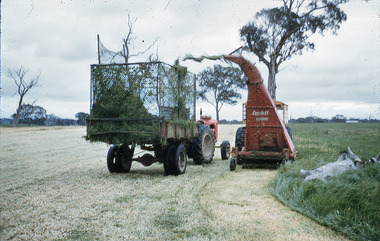
Slide - Mouat Crawford Collection: Farming Life in the Wimmera, 1960s
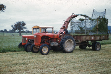
... ...grass cutting...Cutting the grass and loading into truck ready for ensilage....History House 11 Mackenzie Street Bendigo goldfields BHS Collection farming wimmera wheat grass cutting mouat crawford collection Cutting the grass and loading into truck ready for ensilage. ...BHS CollectionCutting the grass and loading into truck ready for ensilage.farming, wimmera, wheat, grass cutting, mouat crawford collection -
 Friends of Ballarat Botanical Gardens History Group
Work on paper - The Northern Gardens and the Cutting of Grass, The Use of the Northern Gardens by the Mental Hospital for Grazing Cattle
... The Northern Gardens and the Cutting of Grass...The Northern Gardens and the Cutting of Grass. The Use of the Northern Gardens by the Mental Hospital for Grazing Cattle....John Garner Collection Ballarat Botanical Gardens Metal Hospital Grass Northern Gardens Gardens Ballarat The Use of the Northern Gardens by the Mental Hospital for Grazing Cattle. Work on paper The Northern Gardens and the Cutting of Grass ...The Northern Gardens and the Cutting of Grass. The Use of the Northern Gardens by the Mental Hospital for Grazing Cattle.john garner collection, ballarat botanical gardens, metal hospital, grass, northern gardens, gardens, ballarat -
Marysville & District Historical Society
THE TRIANGLE NEWS-VOL 1-NO 18-NOVEMBER 19 1976
... ...grass cutting...Marysville & District Historical Society 39 Darwin Street Marysville yarra-valley-and-the-dandenong-ranges marysville victoria australia kayleen ratcliffe in hospital best wishes fire season cricket first aid classes community care centre narbethong primary school buxton primary school wanted grass cutting marysville preschool and infant welfare centre lions christmas cake boots dancing shoes mcleod cabaret tonight father to son bowls alexandra and district arts group new year's eve crossways at the primary school did you know syzygy THE TRIANGLE NEWS-VOL 1-NO 18-NOVEMBER 19 1976 ...marysville, victoria, australia, kayleen ratcliffe in hospital, best wishes, fire season, cricket, first aid classes, community care centre, narbethong primary school, buxton primary school, wanted, grass cutting, marysville preschool and infant welfare centre, lions christmas cake, boots dancing shoes mcleod, cabaret tonight, father to son, bowls, alexandra and district arts group, new year's eve crossways, at the primary school, did you know syzygy -
 Puffing Billy Railway
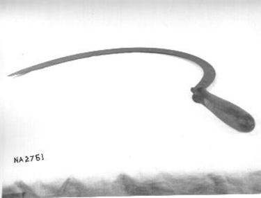
Tool - Sickle, Grass
... ...grass cutting...Historic - Railway Permanent Way and Works - track equipment - Grass Slasher puffing billy extended sickle farm tool reaping hook curved blade grass cutting Wrought iron sickle with extended with wooden handle. ...During early farming in Australia (before motorised whipper snippers) the hand held sickle was used to cut long grass, in this case in or around railway tracks. The inside of the blade's curve was sharp, so that the user can either draw or swing it against the base of the grass, catching the stems in the curve and slicing them at the same time. Historic - Railway Permanent Way and Works - track equipment - Grass SlasherWrought iron sickle with extended with wooden handle.puffing billy, extended sickle, farm tool, reaping hook, curved blade, grass cutting -
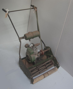 University of Melbourne, Burnley Campus Archives
Tool - Garden maintenance machine, ATCO, Lawn Mower, 1961-1962
... ...grass cutting...University of Melbourne, Burnley Campus Archives 500 Yarra Boulevard Richmond melbourne Used for garden maintenance and for teaching greens maintenance at Burnley College garden maintenance students grass cutting mower lawn mower artifact Machine Reference 1761/2 Made by Charles H. ...Used for garden maintenance and for teaching greens maintenance at Burnley CollegeATCO lightweight petrol lawnmower. 17 inch. With wooden height adjustable forward rollers, rotating metal grass cutter and metal roller. See B91.35.Machine Reference 1761/2 Made by Charles H. Pugh Ltd. Birmingham Englandgarden maintenance, students, grass cutting, mower, lawn mower, artifact -
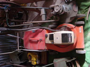 Maldon Vintage Machinery Museum Inc
Motor Mower
... ...grass cutting...Maldon Vintage Machinery Museum Inc Vincents Road Maldon goldfields A rare object, not many were manufactured because of an inherent design fault in positioning the pistons vertically and it was found there was insufficient pressure to deliver oil to the top one. mower grass cutting domestic On engine cowl "500 Twin / 170 cc 2 Stroke". ...A rare object, not many were manufactured because of an inherent design fault in positioning the pistons vertically and it was found there was insufficient pressure to deliver oil to the top one.Victa twin cylinder rotary mower with grass catcher. Rubber tired wheels. Painted orange.On engine cowl "500 Twin / 170 cc 2 Stroke". On base "Victa".mower, grass cutting, domestic -
 Ringwood and District Historical Society
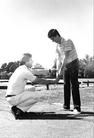
Photograph, Ringwood Golf Club Pro, Peter Harvey, giving a pupil a lesson and photo of four ladies putting out on the 8th green. (undated), unknown
... 2 black and white photographs, one golf pro with pupil and 1 of four ladies on green and man on a grass cutting machine. (undated) +Additional Keywords: Harvey, Peter...Ringwood and District Historical Society 125A Warrandyte Road Ringwood North melbourne Ringwood Golf Club Pro giving a pupil a lesson and photo of four ladies putting out on a green. 2 black and white photographs, one golf pro with pupil and 1 of four ladies on green and man on a grass cutting machine. (undated) +Additional Keywords: Harvey, Peter Ringwood Golf Club Pro, Peter Harvey, giving a pupil a lesson and photo of four ladies putting out on the 8th green. ...Ringwood Golf Club Pro giving a pupil a lesson and photo of four ladies putting out on a green.2 black and white photographs, one golf pro with pupil and 1 of four ladies on green and man on a grass cutting machine. (undated) +Additional Keywords: Harvey, Peter -
 Mt Dandenong & District Historical Society Inc.
Photograph
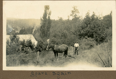
... The photograph shows Ted Child with his working horse Spark cutting grass at his homestead on Childs Road. ...Black and white photograph showing a man with a working horse cutting grass. They are working along a fenceline with a house visible alongside....Farndons Community Hall 42 Falls Road Mt Dandenong yarra-valley-and-the-dandenong-ranges The photograph shows Ted Child with his working horse Spark cutting grass at his homestead on Childs Road. ...The photograph shows Ted Child with his working horse Spark cutting grass at his homestead on Childs Road. The photograph was taken by his daughter Ivy Child. Ivy May Child (1910 – 1989) was the daughter of Arthur Edward (Ted) Child (1878 – 1964) and Ethel May Madden (1888 – 1970). Ted Child was the son of Matthew Francis Child (1839 – 1933) and Martha Jeeves (1857 – 1926). He was the grandson of one of the early pioneers Francis Child. Ivy grew up on the family property on Childs Road and took many photographs. Most of these are glued into her photo album. The album covered the years from c1927 – 1932. Ivy married Henry William Burgess (1906 – 1968) in 1944. The photographs remain in their original state in the album with individual copies made. Black and white photograph showing a man with a working horse cutting grass. They are working along a fenceline with a house visible alongside.Written below photograph in album - Spark againted child, child, horse, ivy child, homestead -
 Bendigo Historical Society Inc.
Slide - Mouat Crawford Collection: Farming Life in the Wimmera, c1960s
... Cutting grass and loading it on truck for ensilage making. ...History House 11 Mackenzie Street Bendigo goldfields farming wimmera mouat crawford collection grass silage Kodak Cutting grass and loading it on truck for ensilage making. ...Cutting grass and loading it on truck for ensilage making. Used as a teaching aid.Kodakfarming, wimmera, mouat crawford collection, grass silage -
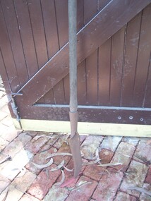
 Kiewa Valley Historical Society
Tool - Sickle
... It is used for harvesting the crops, grass and cutting other vegetative matters. The previous KVHS committee referred to it as a '"Hand Craft Cutter"....It is used for harvesting the crops, grass and cutting other vegetative matters. The previous KVHS committee referred to it as a '"Hand Craft Cutter". ...The sickle was used to cut crops and grass and vegetable matter. It has been in use for a very long time but has probably been superceded by electric tools in developed countries.This sickle was used by a resident of the Kiewa Valley.A curved steel edged blade fixed to a short wooden handle. It is used for harvesting the crops, grass and cutting other vegetative matters. The previous KVHS committee referred to it as a '"Hand Craft Cutter".sickle, farm tool, garden tool -
 Whitehorse Historical Society Inc.
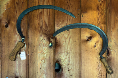
Tool - Sickle
... Wooden handle. Used for cutting grass and hay....Wooden handle. Used for cutting grass and hay. Tool Sickle ...Curved steel blade with serrated edges finishing in a fine tip. Wooden handle. Used for cutting grass and hay.Makers Mark|4rural industry, agriculture -
 City of Moorabbin Historical Society (Operating the Box Cottage Museum)
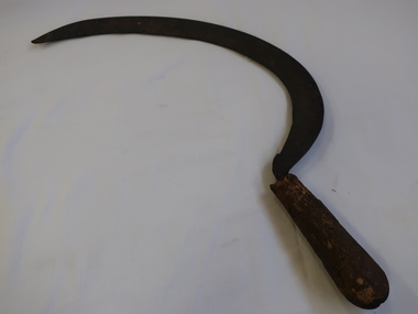
Tools, metal scythe, c1880
... The correct technique has a slicing action on the grass, cutting a narrow strip with each stroke Mowing grass is easier when it is damp, and so hay-making traditionally began at dawn and often stopped early, the heat of the day being spent raking and carting the hay cut on previous days...The correct technique has a slicing action on the grass, cutting a narrow strip with each stroke Mowing grass is easier when it is damp, and so hay-making traditionally began at dawn and often stopped early, the heat of the day being spent raking and carting the hay cut on previous days Early settlers and market gardeners used these scythes as they established their farms in Moorabbin Shire c1880 early settlers pioneers market gardeners moorabbin bentleigh brighton cheltenham tools blacksmiths A large metal scythe with a wooden handle x 2 Tools, metal scythe Unrecorded ...A scythe is an agricultural hand tool for mowing grass or reaping crops. It was largely replaced by horse-drawn and then tractor machinery. A scythe consists of a wooden shaft and a long, curved blade is mounted at the lower end, perpendicular. Scythes always have the blade projecting from the left side when in use. Mowing is done by holding the handle , with the arms straight, the blade parallel to the ground and very close to it, and the body twisted to the right. The body is then twisted steadily to the left, moving the scythe blade along its length in a long arc from right to left, ending in front of the mower, thus depositing the cut grass to the left. Mowing proceeds with a steady rhythm, stopping at frequent intervals to sharpen the blade. The correct technique has a slicing action on the grass, cutting a narrow strip with each stroke Mowing grass is easier when it is damp, and so hay-making traditionally began at dawn and often stopped early, the heat of the day being spent raking and carting the hay cut on previous daysEarly settlers and market gardeners used these scythes as they established their farms in Moorabbin Shire c1880A large metal scythe with a wooden handle x 2early settlers, pioneers, market gardeners, moorabbin, bentleigh, brighton, cheltenham, tools, blacksmiths -
 Ringwood and District Historical Society
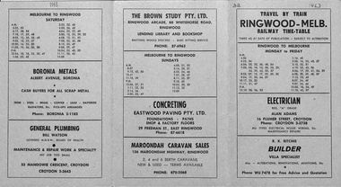
Document, Railway Time Table. Ringwood to Melbourne and Melbourne to Ringwood from 1963
... Tortice of Ringwood), Grass Cutting (C.G. Pattenden of Adelaide St, Ringwood), Motor Mowers Sales and Service (John Salisbury of Ringwood), TV Radio Service (D.G. ...Tortice of Ringwood), Grass Cutting (C.G. Pattenden of Adelaide St, Ringwood), Motor Mowers Sales and Service (John Salisbury of Ringwood), TV Radio Service (D.G. ...Light green coloured tri-fold card with black printing. Ringwood to Melbourne and Melbourne to Ringwood timetables, includes Monday to Friday, a separate Saturday and separate Sunday listings. Most of the front and back of folding card contains advertisements, including Electrician (Alan Adams of Croydon), Builder (R.K. Ritchie - villa specialist), Fuel Merchant (H. Tortice of Ringwood), Grass Cutting (C.G. Pattenden of Adelaide St, Ringwood), Motor Mowers Sales and Service (John Salisbury of Ringwood), TV Radio Service (D.G. Hill of Heathmont), Real Estate Agent (A.T. Miles & Son of Ringwood), Women's, Men's & Children's Wear - (Louis Economy Shop of Ringwood), Painting, Decorating & Paperhanging (D.G Jeffs of Heathmont), Fruiterer and Greengrocer (Vincenzo Condello of Ringwood), Pygmalion Ladies' Accessories (Ringwood Arcade), Boronia Metals (Albert Ave, Boronia), General Plumbing (Bill Watson of Croydon), The Brown Study - Lending Library and Bookshop (Ringwood), Concreting - Eastwood Paving Pty Ltd (East Ringwood), Maroondah Caravan Sales (Ringwood), -
 Federation University Historical Collection
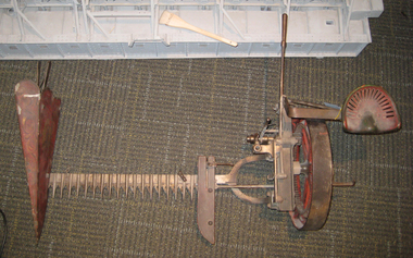
Model, Model of the Munro Reaper, 1887
... Such a machine is now known as a mower for cutting grass for hay, and other grasses for storing as sheaves. ...Such a machine is now known as a mower for cutting grass for hay, and other grasses for storing as sheaves. ...An example of good invention in an era of innovation in Australian manufacture and production. Levers raise the height of the cutter, disengaging the drive from the blades. The moveable blades under the fixed ‘fingers’. An eccentric rod changes circular motion to linear back and forth of the blades. Such a machine is now known as a mower for cutting grass for hay, and other grasses for storing as sheaves. 'Gift for Museum - The School of Mnes committee has accepted the offer from mr H.B. Munro, of Elsternwick, of a model reaping machine made in 1887 when the Munro machinery business was in operation in Alfredton. The model, which has won gold medals at various exhibitions, is to be placed in thr school museum. (Ballarat Courier 22 April 1932) Metal model with red paint detail in sectionsM263ballarat school of mines, ballarat school of mines museum, munro machinery, model, munro reaper -
 Royal Australian and New Zealand College of Obstetricians & Gynaecologists (RANZCOG)
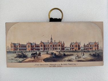
Print - Colour print, Charles Webb, Original design of the Alfred Hospital, c. 1870
... There are two figures in the right foreground cutting grass with scythes. A flock of birds is visible in the sky in the central background, above the main hospital building. ...There are two figures in the right foreground cutting grass with scythes. A flock of birds is visible in the sky in the central background, above the main hospital building. ...This 1870 print displays the original design of The Alfred Hospital by Charles Webb. This design was designed in 'accordance with the principles laid down by Florence Nightingale to maximise ventilation and so minimise infection' (Victorian Heritage Database). The Alfred Hospital was founded in 1869 as a result of the work of various Melbourne doctors who fought a long and internecine battle for an additional general hospital. The Alfred Hospital treated their first patient in 1871. Prahran Council donated a parcel of low-lying land for the provision of a hospital. In 1870, the Melbourne architect, Charles Webb, won the competition to design The Alfred Hospital with his revolutionary design. Webb incorporated the "Nightingale" design - principles by designing large light filled pavilions as wards connected by covered corridors or walkways." (Alfred Health)This print includes small colour print mounted on a wood block. The print depicts a series of five red brick buildings at centre, with a dirt road snaking up from the left foreground to the front of the central building. A man is driving a two-horse buggy along the dirt road towards the buildings. The landscape on either side of the road consists of grassland and low vegetation, as well as four shallow circular pits (two on either side) which contain vegetation. There are two figures in the right foreground cutting grass with scythes. A flock of birds is visible in the sky in the central background, above the main hospital building. There is text printed below the image which reads 'THE ORIGINAL DESIGN OF THE ALFRED HOSPITAL/By C.Webb, Arckitect (sic)'. The back of the wooden block to which the print is affixes is painted black, and a circular hook has been attached to the centre back of the block for hanging of the artwork. The hook is gold coloured and attached using two gold-coloured pins and a small strap. There is handwriting at bottom right of the back of the object reads 'ANN TAVELL'.There is text printed below the image which reads 'THE ORIGINAL DESIGN OF THE ALFRED HOSPITAL/By C.Webb, Arckitect (sic)'. There is handwriting at bottom right of the back of the object reads 'ANN TAVELL'. -
 Eltham District Historical Society Inc
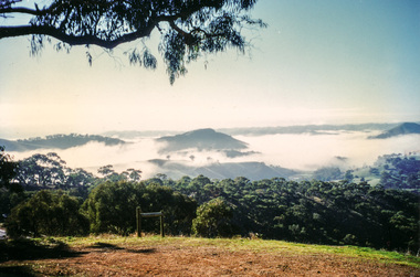
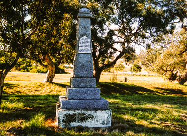
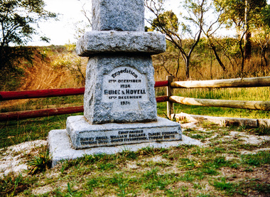
Photograph, Hume and Hovell Monument, Broadford, Autumn Excursion, Hume and Hovell's 1824 expedition, 26 May 1996, 26/05/1996
... Disappointment (Hume and Hovell's difficulties in "scrambling over brush and rock", "leeches in forest, as well as no water", "cutting grass 4-5 ft. high", dreadful scrub", "devil flies") we took an easier route, saw the Strath Creek memorial in ground fog and a wonderful "field of dreams", the Hume-Hovell privately owned cricket ground with its white picket boundary fence. ...Disappointment (Hume and Hovell's difficulties in "scrambling over brush and rock", "leeches in forest, as well as no water", "cutting grass 4-5 ft. high", dreadful scrub", "devil flies") we took an easier route, saw the Strath Creek memorial in ground fog and a wonderful "field of dreams", the Hume-Hovell privately owned cricket ground with its white picket boundary fence. ...[article by Bettina Woodburn in EDHS Newsletter No. 109, July 1996:] ON THE TRAIL OF HUME AND HOVELL - REPORT ON THE AUTUMN EXCURSION - On a green and fresh morning (Sunday 26th May 1996) the Cobb and Co coach (driven by the most obliging Peter Tampion) set off in a north easterly direction from Eltham to connect with Hume and Hovell's route on their 1824 explorations of central Victoria. The Society would follow a series of monuments erected for the 1924 centenary of the expedition from King Parrot Creek (Tuesday 7th December 1824), through Strath Creek, over Sunday Creek (Sunday 12th December 1824) at Broadford, Tullamarine, St Albans, Deer Park, through Werribee, skirting east of the You Yangs to Lara and Avalon Beach. Because their distance-measuring wheel had broken and a one degree mistake was made in calculations, the two leaders of the original group of six convict-companions arrived at Corio Bay, instead of the expected Western Port, discovered earlier by Flinders. From below Mt. Disappointment (Hume and Hovell's difficulties in "scrambling over brush and rock", "leeches in forest, as well as no water", "cutting grass 4-5 ft. high", dreadful scrub", "devil flies") we took an easier route, saw the Strath Creek memorial in ground fog and a wonderful "field of dreams", the Hume-Hovell privately owned cricket ground with its white picket boundary fence. Now, after a steep climb, in sunshine under gums we stretched and viewed magnificent rolling hills and fog-filled valleys - not "smoke from Aborigines' bush fires". After morning tea at Broadford we followed the Sunday Creek valley beside the Hume Freeway, passed the Wallan Wallan Rest Area (more appropriately Hume and Hovell Rest Area) to tum right at Beveridge. In Gellibrand Hill Park, near the headwaters of the Moonee Ponds Creek, we experienced the landscape the first European settlers saw - huge river red gums and rolling pastures. The gardens and sheltered courtyard of the 1840s, timber, brought from .....[?] prefabricated Woodlands Homestead, provided a pleasant lunch stop. We enjoyed a private tour, panoramic views over Melbourne and surroundings and the excitement of arriving and departing aircraft. Our next river crossing was at Werribee, "in a vast treeless plain", then we drove on by-ways no coach had previously travelled, to find "an immense sheet of water" salty Corio Bay, off-course to the west. In late afternoon of a super, calm, late autumn day we headed homewards. Back at Eltham we were rather surprised to find that we had travelled a total of 347 km. Thanks again to Russell Yeoman for his research and organization. What a wonderful day! Colour photographactivities, broadford, hume and hovell, monument -
 Eltham District Historical Society Inc
Photograph, Strath Creek, Autumn Excursion, Hume and Hovell's 1824 expedition, 26 May 1996, 26/05/1996
... Disappointment (Hume and Hovell's difficulties in "scrambling over brush and rock", "leeches in forest, as well as no water", "cutting grass 4-5 ft. high", dreadful scrub", "devil flies") we took an easier route, saw the Strath Creek memorial in ground fog and a wonderful "field of dreams", the Hume-Hovell privately owned cricket ground with its white picket boundary fence. ...Disappointment (Hume and Hovell's difficulties in "scrambling over brush and rock", "leeches in forest, as well as no water", "cutting grass 4-5 ft. high", dreadful scrub", "devil flies") we took an easier route, saw the Strath Creek memorial in ground fog and a wonderful "field of dreams", the Hume-Hovell privately owned cricket ground with its white picket boundary fence. ...[article by Bettina Woodburn in EDHS Newsletter No. 109, July 1996:] ON THE TRAIL OF HUME AND HOVELL - REPORT ON THE AUTUMN EXCURSION - On a green and fresh morning (Sunday 26th May 1996) the Cobb and Co coach (driven by the most obliging Peter Tampion) set off in a north easterly direction from Eltham to connect with Hume and Hovell's route on their 1824 explorations of central Victoria. The Society would follow a series of monuments erected for the 1924 centenary of the expedition from King Parrot Creek (Tuesday 7th December 1824), through Strath Creek, over Sunday Creek (Sunday 12th December 1824) at Broadford, Tullamarine, St Albans, Deer Park, through Werribee, skirting east of the You Yangs to Lara and Avalon Beach. Because their distance-measuring wheel had broken and a one degree mistake was made in calculations, the two leaders of the original group of six convict-companions arrived at Corio Bay, instead of the expected Western Port, discovered earlier by Flinders. From below Mt. Disappointment (Hume and Hovell's difficulties in "scrambling over brush and rock", "leeches in forest, as well as no water", "cutting grass 4-5 ft. high", dreadful scrub", "devil flies") we took an easier route, saw the Strath Creek memorial in ground fog and a wonderful "field of dreams", the Hume-Hovell privately owned cricket ground with its white picket boundary fence. Now, after a steep climb, in sunshine under gums we stretched and viewed magnificent rolling hills and fog-filled valleys - not "smoke from Aborigines' bush fires". After morning tea at Broadford we followed the Sunday Creek valley beside the Hume Freeway, passed the Wallan Wallan Rest Area (more appropriately Hume and Hovell Rest Area) to tum right at Beveridge. In Gellibrand Hill Park, near the headwaters of the Moonee Ponds Creek, we experienced the landscape the first European settlers saw - huge river red gums and rolling pastures. The gardens and sheltered courtyard of the 1840s, timber, brought from .....[?] prefabricated Woodlands Homestead, provided a pleasant lunch stop. We enjoyed a private tour, panoramic views over Melbourne and surroundings and the excitement of arriving and departing aircraft. Our next river crossing was at Werribee, "in a vast treeless plain", then we drove on by-ways no coach had previously travelled, to find "an immense sheet of water" salty Corio Bay, off-course to the west. In late afternoon of a super, calm, late autumn day we headed homewards. Back at Eltham we were rather surprised to find that we had travelled a total of 347 km. Thanks again to Russell Yeoman for his research and organization. What a wonderful day! Colour photographactivities, monument, hume and hovell, murchison valley, strath creek -
 Eltham District Historical Society Inc
Photograph, Murchison Gap viewed from Strath Creek, Autumn Excursion, Hume and Hovell's 1824 expedition, 26 May 1996, 26/05/1996
... Disappointment (Hume and Hovell's difficulties in "scrambling over brush and rock", "leeches in forest, as well as no water", "cutting grass 4-5 ft. high", dreadful scrub", "devil flies") we took an easier route, saw the Strath Creek memorial in ground fog and a wonderful "field of dreams", the Hume-Hovell privately owned cricket ground with its white picket boundary fence. ...Disappointment (Hume and Hovell's difficulties in "scrambling over brush and rock", "leeches in forest, as well as no water", "cutting grass 4-5 ft. high", dreadful scrub", "devil flies") we took an easier route, saw the Strath Creek memorial in ground fog and a wonderful "field of dreams", the Hume-Hovell privately owned cricket ground with its white picket boundary fence. ...[article by Bettina Woodburn in EDHS Newsletter No. 109, July 1996:] ON THE TRAIL OF HUME AND HOVELL - REPORT ON THE AUTUMN EXCURSION - On a green and fresh morning (Sunday 26th May 1996) the Cobb and Co coach (driven by the most obliging Peter Tampion) set off in a north easterly direction from Eltham to connect with Hume and Hovell's route on their 1824 explorations of central Victoria. The Society would follow a series of monuments erected for the 1924 centenary of the expedition from King Parrot Creek (Tuesday 7th December 1824), through Strath Creek, over Sunday Creek (Sunday 12th December 1824) at Broadford, Tullamarine, St Albans, Deer Park, through Werribee, skirting east of the You Yangs to Lara and Avalon Beach. Because their distance-measuring wheel had broken and a one degree mistake was made in calculations, the two leaders of the original group of six convict-companions arrived at Corio Bay, instead of the expected Western Port, discovered earlier by Flinders. From below Mt. Disappointment (Hume and Hovell's difficulties in "scrambling over brush and rock", "leeches in forest, as well as no water", "cutting grass 4-5 ft. high", dreadful scrub", "devil flies") we took an easier route, saw the Strath Creek memorial in ground fog and a wonderful "field of dreams", the Hume-Hovell privately owned cricket ground with its white picket boundary fence. Now, after a steep climb, in sunshine under gums we stretched and viewed magnificent rolling hills and fog-filled valleys - not "smoke from Aborigines' bush fires". After morning tea at Broadford we followed the Sunday Creek valley beside the Hume Freeway, passed the Wallan Wallan Rest Area (more appropriately Hume and Hovell Rest Area) to tum right at Beveridge. In Gellibrand Hill Park, near the headwaters of the Moonee Ponds Creek, we experienced the landscape the first European settlers saw - huge river red gums and rolling pastures. The gardens and sheltered courtyard of the 1840s, timber, brought from .....[?] prefabricated Woodlands Homestead, provided a pleasant lunch stop. We enjoyed a private tour, panoramic views over Melbourne and surroundings and the excitement of arriving and departing aircraft. Our next river crossing was at Werribee, "in a vast treeless plain", then we drove on by-ways no coach had previously travelled, to find "an immense sheet of water" salty Corio Bay, off-course to the west. In late afternoon of a super, calm, late autumn day we headed homewards. Back at Eltham we were rather surprised to find that we had travelled a total of 347 km. Thanks again to Russell Yeoman for his research and organization. What a wonderful day! Colour photographactivities, hume and hovell, murchison valley, murchison gap, strath creek -
 Eltham District Historical Society Inc
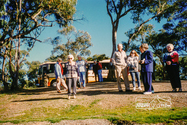
Photograph, Autumn Excursion, Hume and Hovell's 1824 expedition, 26 May 1996, 26/05/1996
... Disappointment (Hume and Hovell's difficulties in "scrambling over brush and rock", "leeches in forest, as well as no water", "cutting grass 4-5 ft. high", dreadful scrub", "devil flies") we took an easier route, saw the Strath Creek memorial in ground fog and a wonderful "field of dreams", the Hume-Hovell privately owned cricket ground with its white picket boundary fence. ...Disappointment (Hume and Hovell's difficulties in "scrambling over brush and rock", "leeches in forest, as well as no water", "cutting grass 4-5 ft. high", dreadful scrub", "devil flies") we took an easier route, saw the Strath Creek memorial in ground fog and a wonderful "field of dreams", the Hume-Hovell privately owned cricket ground with its white picket boundary fence. ...[article by Bettina Woodburn in EDHS Newsletter No. 109, July 1996:] ON THE TRAIL OF HUME AND HOVELL - REPORT ON THE AUTUMN EXCURSION - On a green and fresh morning (Sunday 26th May 1996) the Cobb and Co coach (driven by the most obliging Peter Tampion) set off in a north easterly direction from Eltham to connect with Hume and Hovell's route on their 1824 explorations of central Victoria. The Society would follow a series of monuments erected for the 1924 centenary of the expedition from King Parrot Creek (Tuesday 7th December 1824), through Strath Creek, over Sunday Creek (Sunday 12th December 1824) at Broadford, Tullamarine, St Albans, Deer Park, through Werribee, skirting east of the You Yangs to Lara and Avalon Beach. Because their distance-measuring wheel had broken and a one degree mistake was made in calculations, the two leaders of the original group of six convict-companions arrived at Corio Bay, instead of the expected Western Port, discovered earlier by Flinders. From below Mt. Disappointment (Hume and Hovell's difficulties in "scrambling over brush and rock", "leeches in forest, as well as no water", "cutting grass 4-5 ft. high", dreadful scrub", "devil flies") we took an easier route, saw the Strath Creek memorial in ground fog and a wonderful "field of dreams", the Hume-Hovell privately owned cricket ground with its white picket boundary fence. Now, after a steep climb, in sunshine under gums we stretched and viewed magnificent rolling hills and fog-filled valleys - not "smoke from Aborigines' bush fires". After morning tea at Broadford we followed the Sunday Creek valley beside the Hume Freeway, passed the Wallan Wallan Rest Area (more appropriately Hume and Hovell Rest Area) to tum right at Beveridge. In Gellibrand Hill Park, near the headwaters of the Moonee Ponds Creek, we experienced the landscape the first European settlers saw - huge river red gums and rolling pastures. The gardens and sheltered courtyard of the 1840s, timber, brought from .....[?] prefabricated Woodlands Homestead, provided a pleasant lunch stop. We enjoyed a private tour, panoramic views over Melbourne and surroundings and the excitement of arriving and departing aircraft. Our next river crossing was at Werribee, "in a vast treeless plain", then we drove on by-ways no coach had previously travelled, to find "an immense sheet of water" salty Corio Bay, off-course to the west. In late afternoon of a super, calm, late autumn day we headed homewards. Back at Eltham we were rather surprised to find that we had travelled a total of 347 km. Thanks again to Russell Yeoman for his research and organization. What a wonderful day! Colour photographactivities, hume and hovell -
 Eltham District Historical Society Inc
Photograph, Sign to Hume and Hovell Cricket Ground, at Allandale Road, Strath Creek, Autumn Excursion, Hume and Hovell's 1824 expedition, 26 May 1996, 26/05/1996
... Disappointment (Hume and Hovell's difficulties in "scrambling over brush and rock", "leeches in forest, as well as no water", "cutting grass 4-5 ft. high", dreadful scrub", "devil flies") we took an easier route, saw the Strath Creek memorial in ground fog and a wonderful "field of dreams", the Hume-Hovell privately owned cricket ground with its white picket boundary fence. ...Disappointment (Hume and Hovell's difficulties in "scrambling over brush and rock", "leeches in forest, as well as no water", "cutting grass 4-5 ft. high", dreadful scrub", "devil flies") we took an easier route, saw the Strath Creek memorial in ground fog and a wonderful "field of dreams", the Hume-Hovell privately owned cricket ground with its white picket boundary fence. ...[article by Bettina Woodburn in EDHS Newsletter No. 109, July 1996:] ON THE TRAIL OF HUME AND HOVELL - REPORT ON THE AUTUMN EXCURSION - On a green and fresh morning (Sunday 26th May 1996) the Cobb and Co coach (driven by the most obliging Peter Tampion) set off in a north easterly direction from Eltham to connect with Hume and Hovell's route on their 1824 explorations of central Victoria. The Society would follow a series of monuments erected for the 1924 centenary of the expedition from King Parrot Creek (Tuesday 7th December 1824), through Strath Creek, over Sunday Creek (Sunday 12th December 1824) at Broadford, Tullamarine, St Albans, Deer Park, through Werribee, skirting east of the You Yangs to Lara and Avalon Beach. Because their distance-measuring wheel had broken and a one degree mistake was made in calculations, the two leaders of the original group of six convict-companions arrived at Corio Bay, instead of the expected Western Port, discovered earlier by Flinders. From below Mt. Disappointment (Hume and Hovell's difficulties in "scrambling over brush and rock", "leeches in forest, as well as no water", "cutting grass 4-5 ft. high", dreadful scrub", "devil flies") we took an easier route, saw the Strath Creek memorial in ground fog and a wonderful "field of dreams", the Hume-Hovell privately owned cricket ground with its white picket boundary fence. Now, after a steep climb, in sunshine under gums we stretched and viewed magnificent rolling hills and fog-filled valleys - not "smoke from Aborigines' bush fires". After morning tea at Broadford we followed the Sunday Creek valley beside the Hume Freeway, passed the Wallan Wallan Rest Area (more appropriately Hume and Hovell Rest Area) to tum right at Beveridge. In Gellibrand Hill Park, near the headwaters of the Moonee Ponds Creek, we experienced the landscape the first European settlers saw - huge river red gums and rolling pastures. The gardens and sheltered courtyard of the 1840s, timber, brought from .....[?] prefabricated Woodlands Homestead, provided a pleasant lunch stop. We enjoyed a private tour, panoramic views over Melbourne and surroundings and the excitement of arriving and departing aircraft. Our next river crossing was at Werribee, "in a vast treeless plain", then we drove on by-ways no coach had previously travelled, to find "an immense sheet of water" salty Corio Bay, off-course to the west. In late afternoon of a super, calm, late autumn day we headed homewards. Back at Eltham we were rather surprised to find that we had travelled a total of 347 km. Thanks again to Russell Yeoman for his research and organization. What a wonderful day! Colour photographactivities, hume and hovell, allandale road, strath creek -
 Eltham District Historical Society Inc
Photograph, Autumn Excursion, Hume and Hovell's 1824 expedition, 26 May 1996, 26/05/1996
... Disappointment (Hume and Hovell's difficulties in "scrambling over brush and rock", "leeches in forest, as well as no water", "cutting grass 4-5 ft. high", dreadful scrub", "devil flies") we took an easier route, saw the Strath Creek memorial in ground fog and a wonderful "field of dreams", the Hume-Hovell privately owned cricket ground with its white picket boundary fence. ...Disappointment (Hume and Hovell's difficulties in "scrambling over brush and rock", "leeches in forest, as well as no water", "cutting grass 4-5 ft. high", dreadful scrub", "devil flies") we took an easier route, saw the Strath Creek memorial in ground fog and a wonderful "field of dreams", the Hume-Hovell privately owned cricket ground with its white picket boundary fence. ...[article by Bettina Woodburn in EDHS Newsletter No. 109, July 1996:] ON THE TRAIL OF HUME AND HOVELL - REPORT ON THE AUTUMN EXCURSION - On a green and fresh morning (Sunday 26th May 1996) the Cobb and Co coach (driven by the most obliging Peter Tampion) set off in a north easterly direction from Eltham to connect with Hume and Hovell's route on their 1824 explorations of central Victoria. The Society would follow a series of monuments erected for the 1924 centenary of the expedition from King Parrot Creek (Tuesday 7th December 1824), through Strath Creek, over Sunday Creek (Sunday 12th December 1824) at Broadford, Tullamarine, St Albans, Deer Park, through Werribee, skirting east of the You Yangs to Lara and Avalon Beach. Because their distance-measuring wheel had broken and a one degree mistake was made in calculations, the two leaders of the original group of six convict-companions arrived at Corio Bay, instead of the expected Western Port, discovered earlier by Flinders. From below Mt. Disappointment (Hume and Hovell's difficulties in "scrambling over brush and rock", "leeches in forest, as well as no water", "cutting grass 4-5 ft. high", dreadful scrub", "devil flies") we took an easier route, saw the Strath Creek memorial in ground fog and a wonderful "field of dreams", the Hume-Hovell privately owned cricket ground with its white picket boundary fence. Now, after a steep climb, in sunshine under gums we stretched and viewed magnificent rolling hills and fog-filled valleys - not "smoke from Aborigines' bush fires". After morning tea at Broadford we followed the Sunday Creek valley beside the Hume Freeway, passed the Wallan Wallan Rest Area (more appropriately Hume and Hovell Rest Area) to tum right at Beveridge. In Gellibrand Hill Park, near the headwaters of the Moonee Ponds Creek, we experienced the landscape the first European settlers saw - huge river red gums and rolling pastures. The gardens and sheltered courtyard of the 1840s, timber, brought from .....[?] prefabricated Woodlands Homestead, provided a pleasant lunch stop. We enjoyed a private tour, panoramic views over Melbourne and surroundings and the excitement of arriving and departing aircraft. Our next river crossing was at Werribee, "in a vast treeless plain", then we drove on by-ways no coach had previously travelled, to find "an immense sheet of water" salty Corio Bay, off-course to the west. In late afternoon of a super, calm, late autumn day we headed homewards. Back at Eltham we were rather surprised to find that we had travelled a total of 347 km. Thanks again to Russell Yeoman for his research and organization. What a wonderful day! Colour photographactivities, hume and hovell -
 Eltham District Historical Society Inc
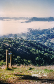
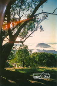
Photograph, Murchison Gap, Autumn Excursion, Hume and Hovell's 1824 expedition, 26 May 1996, 26/05/1996
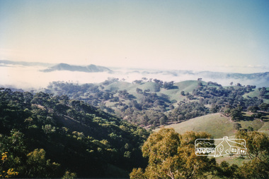
... Disappointment (Hume and Hovell's difficulties in "scrambling over brush and rock", "leeches in forest, as well as no water", "cutting grass 4-5 ft. high", dreadful scrub", "devil flies") we took an easier route, saw the Strath Creek memorial in ground fog and a wonderful "field of dreams", the Hume-Hovell privately owned cricket ground with its white picket boundary fence. ...Disappointment (Hume and Hovell's difficulties in "scrambling over brush and rock", "leeches in forest, as well as no water", "cutting grass 4-5 ft. high", dreadful scrub", "devil flies") we took an easier route, saw the Strath Creek memorial in ground fog and a wonderful "field of dreams", the Hume-Hovell privately owned cricket ground with its white picket boundary fence. ...[article by Bettina Woodburn in EDHS Newsletter No. 109, July 1996:] ON THE TRAIL OF HUME AND HOVELL - REPORT ON THE AUTUMN EXCURSION - On a green and fresh morning (Sunday 26th May 1996) the Cobb and Co coach (driven by the most obliging Peter Tampion) set off in a north easterly direction from Eltham to connect with Hume and Hovell's route on their 1824 explorations of central Victoria. The Society would follow a series of monuments erected for the 1924 centenary of the expedition from King Parrot Creek (Tuesday 7th December 1824), through Strath Creek, over Sunday Creek (Sunday 12th December 1824) at Broadford, Tullamarine, St Albans, Deer Park, through Werribee, skirting east of the You Yangs to Lara and Avalon Beach. Because their distance-measuring wheel had broken and a one degree mistake was made in calculations, the two leaders of the original group of six convict-companions arrived at Corio Bay, instead of the expected Western Port, discovered earlier by Flinders. From below Mt. Disappointment (Hume and Hovell's difficulties in "scrambling over brush and rock", "leeches in forest, as well as no water", "cutting grass 4-5 ft. high", dreadful scrub", "devil flies") we took an easier route, saw the Strath Creek memorial in ground fog and a wonderful "field of dreams", the Hume-Hovell privately owned cricket ground with its white picket boundary fence. Now, after a steep climb, in sunshine under gums we stretched and viewed magnificent rolling hills and fog-filled valleys - not "smoke from Aborigines' bush fires". After morning tea at Broadford we followed the Sunday Creek valley beside the Hume Freeway, passed the Wallan Wallan Rest Area (more appropriately Hume and Hovell Rest Area) to tum right at Beveridge. In Gellibrand Hill Park, near the headwaters of the Moonee Ponds Creek, we experienced the landscape the first European settlers saw - huge river red gums and rolling pastures. The gardens and sheltered courtyard of the 1840s, timber, brought from .....[?] prefabricated Woodlands Homestead, provided a pleasant lunch stop. We enjoyed a private tour, panoramic views over Melbourne and surroundings and the excitement of arriving and departing aircraft. Our next river crossing was at Werribee, "in a vast treeless plain", then we drove on by-ways no coach had previously travelled, to find "an immense sheet of water" salty Corio Bay, off-course to the west. In late afternoon of a super, calm, late autumn day we headed homewards. Back at Eltham we were rather surprised to find that we had travelled a total of 347 km. Thanks again to Russell Yeoman for his research and organization. What a wonderful day! Three colour photographsactivities, murchison gap, murchison valley -
 Eltham District Historical Society Inc
Photograph, Hume and Hovell Monument, Broadford, Autumn Excursion, Hume and Hovell's 1824 expedition, 26 May 1996, 26/05/1996
... Disappointment (Hume and Hovell's difficulties in "scrambling over brush and rock", "leeches in forest, as well as no water", "cutting grass 4-5 ft. high", dreadful scrub", "devil flies") we took an easier route, saw the Strath Creek memorial in ground fog and a wonderful "field of dreams", the Hume-Hovell privately owned cricket ground with its white picket boundary fence. ...Disappointment (Hume and Hovell's difficulties in "scrambling over brush and rock", "leeches in forest, as well as no water", "cutting grass 4-5 ft. high", dreadful scrub", "devil flies") we took an easier route, saw the Strath Creek memorial in ground fog and a wonderful "field of dreams", the Hume-Hovell privately owned cricket ground with its white picket boundary fence. ...[article by Bettina Woodburn in EDHS Newsletter No. 109, July 1996:] ON THE TRAIL OF HUME AND HOVELL - REPORT ON THE AUTUMN EXCURSION - On a green and fresh morning (Sunday 26th May 1996) the Cobb and Co coach (driven by the most obliging Peter Tampion) set off in a north easterly direction from Eltham to connect with Hume and Hovell's route on their 1824 explorations of central Victoria. The Society would follow a series of monuments erected for the 1924 centenary of the expedition from King Parrot Creek (Tuesday 7th December 1824), through Strath Creek, over Sunday Creek (Sunday 12th December 1824) at Broadford, Tullamarine, St Albans, Deer Park, through Werribee, skirting east of the You Yangs to Lara and Avalon Beach. Because their distance-measuring wheel had broken and a one degree mistake was made in calculations, the two leaders of the original group of six convict-companions arrived at Corio Bay, instead of the expected Western Port, discovered earlier by Flinders. From below Mt. Disappointment (Hume and Hovell's difficulties in "scrambling over brush and rock", "leeches in forest, as well as no water", "cutting grass 4-5 ft. high", dreadful scrub", "devil flies") we took an easier route, saw the Strath Creek memorial in ground fog and a wonderful "field of dreams", the Hume-Hovell privately owned cricket ground with its white picket boundary fence. Now, after a steep climb, in sunshine under gums we stretched and viewed magnificent rolling hills and fog-filled valleys - not "smoke from Aborigines' bush fires". After morning tea at Broadford we followed the Sunday Creek valley beside the Hume Freeway, passed the Wallan Wallan Rest Area (more appropriately Hume and Hovell Rest Area) to tum right at Beveridge. In Gellibrand Hill Park, near the headwaters of the Moonee Ponds Creek, we experienced the landscape the first European settlers saw - huge river red gums and rolling pastures. The gardens and sheltered courtyard of the 1840s, timber, brought from .....[?] prefabricated Woodlands Homestead, provided a pleasant lunch stop. We enjoyed a private tour, panoramic views over Melbourne and surroundings and the excitement of arriving and departing aircraft. Our next river crossing was at Werribee, "in a vast treeless plain", then we drove on by-ways no coach had previously travelled, to find "an immense sheet of water" salty Corio Bay, off-course to the west. In late afternoon of a super, calm, late autumn day we headed homewards. Back at Eltham we were rather surprised to find that we had travelled a total of 347 km. Thanks again to Russell Yeoman for his research and organization. What a wonderful day! Colour photographactivities, broadford, hume and hovell, monument -
 Eltham District Historical Society Inc
Photograph, Hume and Hovell Monument, Autumn Excursion, Hume and Hovell's 1824 expedition, 26 May 1996, 26/05/1996
... Disappointment (Hume and Hovell's difficulties in "scrambling over brush and rock", "leeches in forest, as well as no water", "cutting grass 4-5 ft. high", dreadful scrub", "devil flies") we took an easier route, saw the Strath Creek memorial in ground fog and a wonderful "field of dreams", the Hume-Hovell privately owned cricket ground with its white picket boundary fence. ...Disappointment (Hume and Hovell's difficulties in "scrambling over brush and rock", "leeches in forest, as well as no water", "cutting grass 4-5 ft. high", dreadful scrub", "devil flies") we took an easier route, saw the Strath Creek memorial in ground fog and a wonderful "field of dreams", the Hume-Hovell privately owned cricket ground with its white picket boundary fence. ...[article by Bettina Woodburn in EDHS Newsletter No. 109, July 1996:] ON THE TRAIL OF HUME AND HOVELL - REPORT ON THE AUTUMN EXCURSION - On a green and fresh morning (Sunday 26th May 1996) the Cobb and Co coach (driven by the most obliging Peter Tampion) set off in a north easterly direction from Eltham to connect with Hume and Hovell's route on their 1824 explorations of central Victoria. The Society would follow a series of monuments erected for the 1924 centenary of the expedition from King Parrot Creek (Tuesday 7th December 1824), through Strath Creek, over Sunday Creek (Sunday 12th December 1824) at Broadford, Tullamarine, St Albans, Deer Park, through Werribee, skirting east of the You Yangs to Lara and Avalon Beach. Because their distance-measuring wheel had broken and a one degree mistake was made in calculations, the two leaders of the original group of six convict-companions arrived at Corio Bay, instead of the expected Western Port, discovered earlier by Flinders. From below Mt. Disappointment (Hume and Hovell's difficulties in "scrambling over brush and rock", "leeches in forest, as well as no water", "cutting grass 4-5 ft. high", dreadful scrub", "devil flies") we took an easier route, saw the Strath Creek memorial in ground fog and a wonderful "field of dreams", the Hume-Hovell privately owned cricket ground with its white picket boundary fence. Now, after a steep climb, in sunshine under gums we stretched and viewed magnificent rolling hills and fog-filled valleys - not "smoke from Aborigines' bush fires". After morning tea at Broadford we followed the Sunday Creek valley beside the Hume Freeway, passed the Wallan Wallan Rest Area (more appropriately Hume and Hovell Rest Area) to tum right at Beveridge. In Gellibrand Hill Park, near the headwaters of the Moonee Ponds Creek, we experienced the landscape the first European settlers saw - huge river red gums and rolling pastures. The gardens and sheltered courtyard of the 1840s, timber, brought from .....[?] prefabricated Woodlands Homestead, provided a pleasant lunch stop. We enjoyed a private tour, panoramic views over Melbourne and surroundings and the excitement of arriving and departing aircraft. Our next river crossing was at Werribee, "in a vast treeless plain", then we drove on by-ways no coach had previously travelled, to find "an immense sheet of water" salty Corio Bay, off-course to the west. In late afternoon of a super, calm, late autumn day we headed homewards. Back at Eltham we were rather surprised to find that we had travelled a total of 347 km. Thanks again to Russell Yeoman for his research and organization. What a wonderful day! Two colour photographsactivities, hume and hovell, monument -
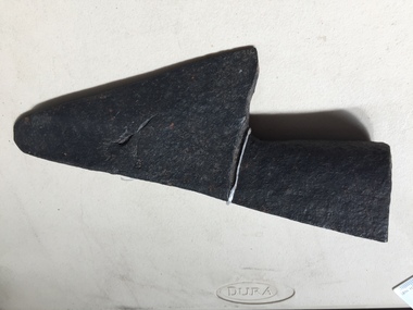 Kiewa Valley Historical Society
Ploughshare
... grass and soil loosening or turning the soil before sowing seed or planting. Ploughs were drawn by oxen and horses. Now drawn by tractors. Farmers in the Kiewa Valley used ploughs before tractors became available. ploughshare agriculture farming crops Formerly KV 060. Made of steel and a component of a plough. It is the cutting ...The ploughshare cuts grass and soil loosening or turning the soil before sowing seed or planting. Ploughs were drawn by oxen and horses. Now drawn by tractors.Farmers in the Kiewa Valley used ploughs before tractors became available.Formerly KV 060. Made of steel and a component of a plough. It is the cutting or leading edge of a mouldboard which closely follows the coulter wen ploughing. Attached picture shows the ploughshare as part of a plough. Ref. Farmyard Relics by Ken Arnold Page 49ploughshare, agriculture, farming crops