Showing 45 items matching "grazing paddock"
-
 University of Melbourne, Burnley Campus Archives
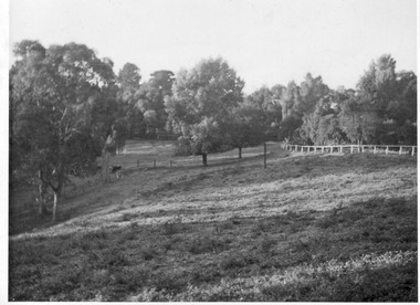
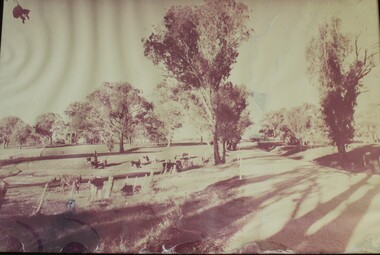
Photograph - Black and white print, E.M. Gibson, Lagoon Paddock, Autumn 1947
... ...grazing paddock...Black and white photograph of the Lagoon Paddock or grazing paddock. Lush pasture and a cow or horse in the distance....phalaris e. m. gibson collection lagoon paddock grazing paddock "Autumn 1947. Sown Phalaris & Sub in Spring of 1946." ...Black and white photograph of the Lagoon Paddock or grazing paddock. Lush pasture and a cow or horse in the distance."Autumn 1947. Sown Phalaris & Sub in Spring of 1946." E M Gibson 2/2phalaris, e. m. gibson collection, lagoon paddock, grazing paddock -
 University of Melbourne, Burnley Campus Archives
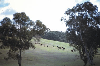
Photograph - Black and white print, E.M. Gibson, Lagoon Paddock, 1948
... ...grazing paddock...Black and white photograph of the view looking towards the Lagoon Paddock (Grazing Paddock) from the Plant Research Laboratory. ...lagoon paddock grazing paddock plant research laboratory e. m. gibson collection 263/7 27 Black and white photograph of the view looking towards the Lagoon Paddock (Grazing Paddock) from the Plant Research Laboratory. ...Black and white photograph of the view looking towards the Lagoon Paddock (Grazing Paddock) from the Plant Research Laboratory. Tree is a Poplar (Cootonwood).263/7 27lagoon paddock, grazing paddock, plant research laboratory, e. m. gibson collection -
 University of Melbourne, Burnley Campus Archives
Photograph - Black and white print, E.M. Gibson, Access Road to P.R.L., Pasture Branch, etc, 1948
... ...grazing paddock...Black and white photograph of the view looking towards the Lagoon Paddock (Grazing Paddock) from the Poultry area. Access roads to the Plant Research Laboratory/Institute, PASTURE bRANCH, ETC....lagoon paddock grazing paddock e. m. gibson collection poultry Ppasture branch plant research laboratory plant research institute 263/2 28 Black and white photograph of the view looking towards the Lagoon Paddock (Grazing Paddock) from the Poultry area. ...Black and white photograph of the view looking towards the Lagoon Paddock (Grazing Paddock) from the Poultry area. Access roads to the Plant Research Laboratory/Institute, PASTURE bRANCH, ETC.263/2 28lagoon paddock, grazing paddock, e. m. gibson collection, poultry, ppasture branch, plant research laboratory, plant research institute -
 Linton and District Historical Society Inc
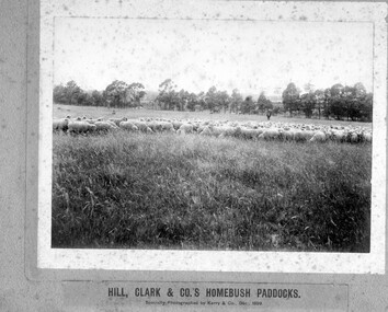
Photograph, Kerry and Co, Sheep farm : Hill, Clarke and Co.'s 'Homebush' paddocks, 1899, 1899
... Sepia photograph of sheep grazing on rural paddocks....'Homebush' Sepia photograph of sheep grazing on rural paddocks. Sheep farm : Hill, Clarke and Co.' ...Sepia photograph of sheep grazing on rural paddocks.rural activity, sheep farming, hill clarke & co., 'homebush' -
 Bendigo Historical Society Inc.
Slide - MALDON & SURROUNDING AREAS, Apr 1968
... Maldon & Surrounding Areas. Cattle grazing in a paddock on a hill....Maldon & Surrounding Areas. Cattle grazing in a paddock on a hill. Slide MALDON & SURROUNDING AREAS. ...Slide. Maldon & Surrounding Areas. Cattle grazing in a paddock on a hill.slide, maldon & surrounding areas., maldon & surrounding areas. -
 University of Melbourne, Burnley Campus Archives
Plan, School of Horticulture - Burnley, 1945
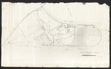
... Includes new building overlaid on Main School Building, experimental plots, orchard, fowl yards, grazing paddocks, fences, drains. B. Photocopies of same plan, enlarged and reduced - one marked "Copy for student project , Oct. 1994"...Includes new building overlaid on Main School Building, experimental plots, orchard, fowl yards, grazing paddocks, fences, drains. B. Photocopies of same plan, enlarged and reduced - one marked "Copy for student project , Oct. 1994" School of Horticulture - Burnley Plan ...A. Plan of School of Horticulture. Burnley Gardens 1945. Shows area from Swan Street - Yarra Boulevard - East Malvern Railway. Includes new building overlaid on Main School Building, experimental plots, orchard, fowl yards, grazing paddocks, fences, drains. B. Photocopies of same plan, enlarged and reduced - one marked "Copy for student project , Oct. 1994" Burnley Gardens 1945, handwritten on reverse.burnley gardens, burnley school of horticulture, buildings, orchard, experimental plots, fowl yards -
 Wodonga & District Historical Society Inc
Photograph - Photo - Felltimber Creek Road, Wodonga, Neil Coles, July 1984
... A large black and white image of cows grazing in a paddock. Image is in a metal and glass frame....It was originally covered in bushland felltimber creek Wodonga 1980s Wodonga scenes A large black and white image of cows grazing in a paddock. Image is in a metal and glass frame. ...Felltimber Creek Road is on the south-eastern edge of West Wodonga. It was originally covered in bushlandA large black and white image of cows grazing in a paddock. Image is in a metal and glass frame.felltimber creek, wodonga 1980s, wodonga scenes -
 Cheese World Museum
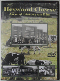
DVD, Heywood Cheese; an oral history on film
... Full colour DVD cover has photograph of Heywood Cheese factory and photographs of girls with calves, milk cans on a truck and workers in the cheese room, superimposed on a photograph of dairy cows grazing in a paddock. The DVD has the photograph of the cows grazing in the paddock....Duration: 70 minutes Full colour DVD cover has photograph of Heywood Cheese factory and photographs of girls with calves, milk cans on a truck and workers in the cheese room, superimposed on a photograph of dairy cows grazing in a paddock. The DVD has the photograph of the cows grazing in the paddock. ...For many years the Heywood Cheese Factory was an important part of life for Heywood and district farming and a vital place of employment for up to 40 men and 10 women. The factory opened in 1939 as a subsidiary of the Portland Butter Factory before becoming a world renowned cheese making enterprise. It was felt important to document its history from the surviving factory workers, including dairy suppliers and milk truck drivers. We hear their stories of the long hours and hard work without penalty rates, travelling unsealed roads and mixed with their humour of the bygone days is an important acknowledgement of that era. [blurb on back cover]This oral history provides significant material relating to the dairy industry in south west Victoria during the mid 20th century. The interviews give first-hand recollections of the interviewees involvement in the industry from a point of view of factory workers, milk pick-up drivers and farmers.Full colour DVD cover has photograph of Heywood Cheese factory and photographs of girls with calves, milk cans on a truck and workers in the cheese room, superimposed on a photograph of dairy cows grazing in a paddock. The DVD has the photograph of the cows grazing in the paddock.Heywood Cheese/An oral history on film (front) For many years Heywood Cheese Factory was ... [see historical information] Edited by Garry Kerr for the Heywood Pioneer Wagon Shed/ Museum History Group who wish to gratefully acknowledge the/ support of the Victorian Government and Public Records Office/ Victoria for making this project possible. Duration: 70 minutesallansford, heywood, cheese factories, cheese manufacturing, dairying, cheese -
 Bendigo Historical Society Inc.
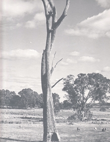
Photograph - AGRICULTURAL SCENE, 1960-70's
... Black and white photo: Landscape view of farming land, with large dead tree in centre foreground. Sheep are grazing in paddocks, stand of eucalypts in background of photo. ...Kennedy Black and white photo: Landscape view of farming land, with large dead tree in centre foreground. Sheep are grazing in paddocks, stand of eucalypts in background of photo. ...Black and white photo: Landscape view of farming land, with large dead tree in centre foreground. Sheep are grazing in paddocks, stand of eucalypts in background of photo. Picture was exhibited in Bendigo Agricultural Show, 1974. Photo is accompanied by First Prize Certificate, Bendigo Show 1974.F. T. Kennedyplace, landscape view, agricultural -
 Lakes Entrance Historical Society
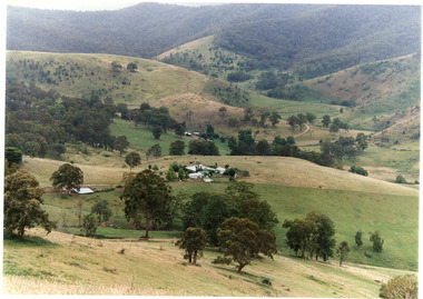
Photograph - Gillingal Station, Tambo Shire, 1994 c
... Colour photograph of Gillingal Station, showing the farm buildings situated on a hillside and surrounded by rising hill country and fertile valleys, cattle grazing in home paddock. Buchan Victoria...Lakes Entrance Historical Society 4 Marine Parade Lakes Entrance gippsland Also second identical copy Agriculture Primary industry Colour photograph of Gillingal Station, showing the farm buildings situated on a hillside and surrounded by rising hill country and fertile valleys, cattle grazing in home paddock. Buchan Victoria Photograph Gillingal Station Tambo Shire ...Also second identical copyColour photograph of Gillingal Station, showing the farm buildings situated on a hillside and surrounded by rising hill country and fertile valleys, cattle grazing in home paddock. Buchan Victoriaagriculture, primary industry -
 Whitehorse Historical Society Inc.
Functional object - Printing block
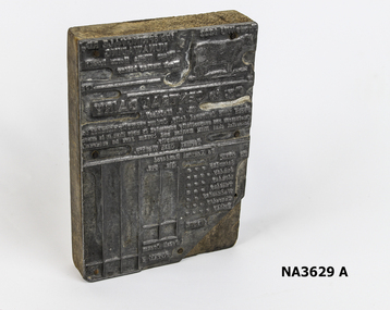
... In note from Lorraine 'G 'who donated items, McGhee's cows grazed in a paddock which is now the site of Nunawading McDonald's. ...Whitehorse Historical Society Inc. 2-10 Deep Creek Road Mitcham melbourne In note from Lorraine 'G 'who donated items, McGhee's cows grazed in a paddock which is now the site of Nunawading McDonald's. ...In note from Lorraine 'G 'who donated items, McGhee's cows grazed in a paddock which is now the site of Nunawading McDonald's. Mrs Nell McGhee had business acumen in the dairy business.Printer's block for account stamp for Central Dairy, 179 Springvale Road, Nunawading for one week's supply of delivered milk and cream. Proprietor, F T McGhee. Also printed account and donor explanatory note.trades, printing, food technology, dairying -
 Bendigo Historical Society Inc.
10 x Invoices from Kennington Dairy, Bendigo, 1940's
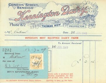
... Letter head at top of each document, with 'Kennington Dairy' in red against dark blue outline of cows grazing in paddock. Thomas Hoy, proprietor, listed on each invoice. ...Letter head at top of each document, with 'Kennington Dairy' in red against dark blue outline of cows grazing in paddock. Thomas Hoy, proprietor, listed on each invoice. ...Kennington Dairy was located in Condon Street east of Albion Street, near the bend in the road. The 1922 Electoral Roll lists Thomas Hoy, Dairy Manager, Condon Street. The 1930 Directory (Victoria) lists Henry W. Hoy and Thomas Hoy of Condon Street, Bendigo. This dairy made the claim that they were the only dairy farm in the state where milk was produced and brine-cooled entirely under vacuum (per print at bottom of invoice).Ten invoices from Kennington Dairy. Five have receipts attached, and five do not. invoices date from 1944 to 1949. Letter head at top of each document, with 'Kennington Dairy' in red against dark blue outline of cows grazing in paddock. Thomas Hoy, proprietor, listed on each invoice. Invoices are either pale green, cream or light blue in color, and printed on thin paper. All invoices made out to Mr Andrew. dairy, bendigo business, hoy, milk -
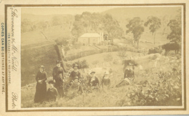 Bacchus Marsh & District Historical Society
Photograph, Cameron family at Glen Head property near Bacchus Marsh 1883
... The image shows a family group, the Cameron family of Bacchus Marsh, standing and sitting in a paddock on their farm. Cows graze in the paddock nearby. ...The image shows a family group, the Cameron family of Bacchus Marsh, standing and sitting in a paddock on their farm. Cows graze in the paddock nearby. ...Malcolm Cameron, came from Scotland to Australia with his wife in 1862. From late 1862 they lived in Bacchus Marsh and remained there for the rest of their lives. After working as a shepherd for sometime Malcolm Cameron was able to acquire land for a farm a few kilometers north west of Bacchus Marsh. The farm was called Glen View but this was later changed to Grand View. It is known to have been a wheat farm, Malcolm Cameron died aged 89 in 1922. His wife died in 1926. Small sepia unframed photograph on card with gold border framing photograph. Housed in the album, 'Photographs of Bacchus Marsh and District in 1883 by Stevenson and McNicoll'. The image shows a family group, the Cameron family of Bacchus Marsh, standing and sitting in a paddock on their farm. Cows graze in the paddock nearby. In the background, in the distance, can be seen the Cameron family home.On the front: Stevenson & McNicoll. Photo. 108 Elizabeth St. Melbourne. COPIES CAN BE OBTAINED AT ANY TIME. On the back: LIGHT & TRUTH inscribed on a banner surmounted by a representation of the rising sun. Copies of this Portrait can be had at any time by sending the Name and Post Office Money Order or Stamps for the amount of order to STEVENSON & McNICOLL LATE BENSON & STEVENSON, Photographers. 108 Elizabeth Street, MELBOURNE. stevenson and mcnicoll 1883 photographs of bacchus marsh and district, farmers, farms, wheat farms, cameron family bacchus marsh -
 Southern Sherbrooke Historical Society Inc.
Photograph, Looking towards Ferntree Gully from Lysterfield
... Three cows are grazing in a large paddock. Houses can be seen in the distance. ...Three cows are grazing in a large paddock. Houses can be seen in the distance. ...Photograph taken possibly from Lysterfield Rd looking towards Ferntree Gully with the Dandenong Ranes in the background. Clusters of letterboxes in foreground then a post and wire fence. Three cows are grazing in a large paddock. Houses can be seen in the distance. There are also marquees, probably at Brenock Park. Photo from Alan Currie collection. Taken c. 1958. -
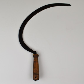 National Wool Museum
Tool - Sickle, Pre. 1988
... Sheep are often pictured grazing in paddocks; however, the grass available in a paddock is often not enough to maintain a sheep’s weight. ...Sheep are often pictured grazing in paddocks; however, the grass available in a paddock is often not enough to maintain a sheep’s weight. ...Feed for sheep farming is crucially important. Whether growing a sheep for breeding, wool or meat, it is vital to ensure that all sheep at whatever stage of life are maintaining or growing in weight. Sheep are often pictured grazing in paddocks; however, the grass available in a paddock is often not enough to maintain a sheep’s weight. In addition, if a sheep eats grass too low in a paddock then corrosion can affect the soil preventing any grass from growing in this location. For these reasons, supplementary feed is introduced to sheep’s diets. In most occasions’ food high in protein such as Lupins is sought. In times such as drought or to makeup a sheep’s roughage; feed such as silage, hay and straw may be required in the feeding of sheep. This is where the sickle is introduced to sheep farming. Although modern-day machines are used to harvest cereals, in times past the sickle was used for harvesting these crops. Once harvested, these crops can be fed to sheep freshly cut or dried. This sickle has been on display for 30 years at the National Wool Museum. It was at the entrance to Gallery One in the “A New Europe” wood hut display case. It was taken off display in 2021 with the “On the Land” redevelopment of this gallery space.Curved Metal serrated blade extending from carved dark wooden handletools of the trade, sheep feed, sheep farming -
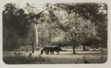 Kew Historical Society Inc
Photograph - Horses grazing near Cockatoo, c.1926
... This photo was taken on a trip between Cockatoo and Gembrook in Victoria and shows two horses grazing in a paddock to the left of an 'exotic' tree in full bloom. ...This photo was taken on a trip between Cockatoo and Gembrook in Victoria and shows two horses grazing in a paddock to the left of an 'exotic' tree in full bloom. ...Henry Beater Christian (1886-1962) , was a descendant of one of the earliest settler families in Kew. Employed at the Kew Asylum as a 'public servant', he was a skilled amateur photographer, photographing numerous scenes in Kew and on his travels around Victoria. The majority of his photographs date from 1916 to 1929. His finest photographs are housed in two photograph albums. Digital copy of a photograph from page 28 of the 47-page photograph album containing 261 gelatinous silver images, loaned by Diane Washfold with permission given to digitise and hold a copy in our collection. John Chapman has written in 'Bushwalking Clubs - A Brief History', about the establishment in Victoria of the first bushwalking club in 1888, and the popularisation of bushwalking during the interwar period. Henry Christian's 'walks' appear to have been undertaken solely or with a companion/s. This photo was taken on a trip between Cockatoo and Gembrook in Victoria and shows two horses grazing in a paddock to the left of an 'exotic' tree in full bloom. "Cockatoo & Gembrook [illegible]henry beater christian (1886-1962), landscape photography, christian-washfold collection, photograph albums, bushwalking, cockatoo, gembrook -
 Eltham District Historical Society Inc
Negative - Photograph, J. P. Lind, Hurst's Bridge, 1885
... Two horses graze in an open paddock in the foreground. A house is situated on a rise behind the bridge on a tree lined hill. ...Two horses graze in an open paddock in the foreground. A house is situated on a rise behind the bridge on a tree lined hill. ...Looking northwest onto the first bridge at Hurstbridge, 1885. Timber bridge amid rural setting. Two horses graze in an open paddock in the foreground. A house is situated on a rise behind the bridge on a tree lined hill. The area of Hurstbridge was originally known as Hurst’s-bridge after the timber bridge built over the Diamond Creek near Hurst’s station in late 1881/early 1882 on the Hurstbridge-Arthurs Creek Road, Hurstbridge. It was built by John McDonald, of Arthur's Creek and was demolished and replaced in 1917 by a reinforced concrete arch bridge designed by John Monash. Cross Reference Photo No.(s): 1012/1013This photo forms part of a collection of photographs gathered by the Shire of Eltham for their centenary project book, "Pioneers and Painters: 100 years of the Shire of Eltham" by Alan Marshall (1971). The collection of over 500 images is held in partnership between Eltham District Historical Society and Yarra Plenty Regional Library (Eltham Library) and is now formally known as 'The Shire of Eltham Pioneers Photograph Collection.' It is significant in being the first community sourced collection representing the places and people of the Shire's first one hundred years.Digital image 4 x 5 inch B&W Negshire of eltham pioneers photograph collection, hurstbridge, bridge, diamond creek (river), diamond creek (creek), hurst's bridge -
 Wodonga & District Historical Society Inc
Artwork, other - Pollard's Creamery, Bonegilla Flats
... The creamery stood until the late 1970s although in a state of ruin and used neaas a scratching post by the cattle which grazed in the surrounding paddock. The creamery included a chimney and fireplace. ...The creamery stood until the late 1970s although in a state of ruin and used neaas a scratching post by the cattle which grazed in the surrounding paddock. The creamery included a chimney and fireplace. ...George Pollard was born in Corfe, Dorsetshire England in 1824. Being dissatisfied as a clay miner, he decided to migrate to Australia. He migrated in 1851 and after a short unsuccessful time on the goldfields in Bendigo, followed by a period in Dederang and farming in Oxley, he selected land on Little River, now know as the Kiewa River in 1868. His property was know as Rosebank and George continued to live there until his death in 1915. In the early 1880s, George Pollard constructed a creamery on his property at Bonegilla Flat. The creamery stood until the late 1970s although in a state of ruin and used neaas a scratching post by the cattle which grazed in the surrounding paddock. The creamery included a chimney and fireplace. This generated warmth so that when large pans of milk were placed near the fire the cram would rise to the top and could easily be separated to produce butter for the growing family. In 1982 Fred Hillier was visiting from Queensland and offered to make the replica of the creamery featured Wodonga & District Historical Society Collection.This item is significant because it represents a creamery owned by an important family in the Bonegilla district.A small model of an old building made from clay. It includes a roof resembling corrugated iron and empty spaces for windows.Underneath Model Bonegilla Creamery 1886 By Fred Hillier 1982pollard family, agricultural buildings -
 Kew Historical Society Inc
Photograph, J F C Farquhar, Studley Park Road, 1891
... Contemporary advertisements for the sale of mansions in Studley Park Road often included fulsome descriptions of their elaborate formal gardens, as well as paddocks for grazing, stabling and dairies. None can be seen here. ...Contemporary advertisements for the sale of mansions in Studley Park Road often included fulsome descriptions of their elaborate formal gardens, as well as paddocks for grazing, stabling and dairies. None can be seen here. ...At the beginning of the 1890s, the Kew businessman and Town Councillor, Henry Kellett, commissioned J.F.C. Farquhar to photograph scenes of Kew. These scenes included panoramas as well as pastoral scenes. The resulting set of twelve photographs was assembled in an album, Kew Where We Live, from which customers could select images for purchase.The preamble to the album describes that the photographs used the ‘argentic bromide’ process, now more commonly known as the gelatine silver process. This form of dry plate photography allowed for the negatives to be kept for weeks before processing, hence its value in landscape photography. The resulting images were considered to be finely grained and everlasting. Evidence of the success of Henry Kellett’s venture can be seen today, in that some of the photographs are held in national collections.It is believed that the Kew Historical Society’s copy of the Kellett album is unique and that the photographs in the book were the first copies taken from the original plates. It is the first and most important series of images produced about Kew. The individual images have proved essential in identifying buildings and places of heritage value in the district.In this view of Studley Park Road, looking northeast to the Junction, the photographer invites the viewer to participate in a point-of-view that emphasises the elevated, tranquil vantage point of the hill in contrast to the bustling commercial area in the distance. The view emphasises the exclusiveness of Studley Park, with its high fences behind which a number of significant Kew mansions were concealed. Contemporary advertisements for the sale of mansions in Studley Park Road often included fulsome descriptions of their elaborate formal gardens, as well as paddocks for grazing, stabling and dairies. None can be seen here. The use of high, protective wooden pickets to surround the newly planted avenue of elms on the south side of the road appears to be typical of the period. Similar examples can be seen in early photographs of Wellington and Princess Streets.The horse and carriage, selected as a central focus of the view, reinforces the residential, exclusive nature of this part of Kew in the early 1890s. Studley Park Roadkew illustrated, kew where we live, photographic books, henry kellett -
 Eltham District Historical Society Inc
Negative - Photograph, Mary Jane Smart (nee Bailey) ouside the Smart family home in Bridge Street, Eltham, c.1915
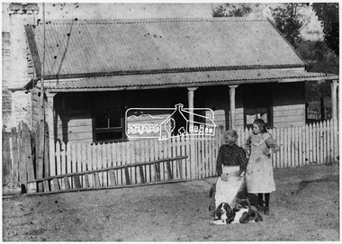
... In a little bush cottage surrounded by tall gum trees, through which appear glimpses of a willow fringed creek, of road ways hedged by masses of snowy flowering hawthorn, of growing crops and vividly green grazing paddocks, lives Mrs. Smart, the lawful wife of the man who is now in the hands of the police of Western Australia on suspicion of having committed a dreadful crime. ...In a little bush cottage surrounded by tall gum trees, through which appear glimpses of a willow fringed creek, of road ways hedged by masses of snowy flowering hawthorn, of growing crops and vividly green grazing paddocks, lives Mrs. Smart, the lawful wife of the man who is now in the hands of the police of Western Australia on suspicion of having committed a dreadful crime. ...Located on the north side of Bridge Street at the intersection with Bolton Street, facing Bolton Street (now part of present day Brisbane Street and occupied by the Kitchen Design Centre). Show's an original early settler's cottage in Bridge Street. The cottage was built by Mrs Mary Jane Smart's parents, Edwin Bailey and Jane (nee Matthews). Mary Jane Smart was born in the cottage. She married an Englishman, Alexander Wilson Smart who disappeared to Western Australia in the early 1900s in search of gold. He ultimately married again in W.A., committing bigamy and then committed murder and was hung in 1911. This photo was taken c.1903 not long before both Mrs Bailey and her grand daughter both passed away. Jane Bailey died 2 Dec. 1904 and Mary Jane Smart and Ruby Jane Bertha Smart died July 1903 are all buried in Eltham Cemetery. SMART'S HOME AT ELTHAM. HIS WIFE AND SONS. In a little bush cottage surrounded by tall gum trees, through which appear glimpses of a willow fringed creek, of road ways hedged by masses of snowy flowering hawthorn, of growing crops and vividly green grazing paddocks, lives Mrs. Smart, the lawful wife of the man who is now in the hands of the police of Western Australia on suspicion of having committed a dreadful crime. Here, about half a mile out of the picturesque village of Eltham, she was born, and has lived her whole life — about 50 years. Smart himself lived here till the time when many years ago, the "lure of gold" got into his blood and he cleared out to Western Australia, to follow the digging rushes, gradually becom ing more and more estranged, till at length all communication ceased and be became lost to his wife and children. "I did not want him to go away," said Mrs. Smart, "because I had heard of so many men who had forgotten their homes in the excite ment of gold seeking, and of many others who died unknown and uncared for. But he would go, and when I saw his mind was set on it I placed no obstacles in his way. My parents built and lived in this cottage, where I was born, and they died in it. When I grew up I met my husband, a young Englishman, and married him. His name is Alexander, not Alfred, and his age is 52. We were very happy here, and although we were not well off we were comfortable, for he was a steady, sober, industrious man and had constant employment. He was just a manual worker, but could turn his hand to anything. We had five children, but one died. Four sons grew up in this little cottage. Thus three generations lived in it, somewhat unusual in an Australian bush home, I think. My eldest son is married and has a family; one is in Western Australia— not with his father— another is away working for him self, and one (indicating a young man by her side) has always stuck to his mother. He is my sole support, and he is as good to me now as his father once was. Yes, his father was a good, home-loving man in our younger days. He was fond of his children and was highly respected in these parts.' "It is fifteen years since my husband went away first. He had then been work ing for the Metropolitan Board of Works, and was engaged in the tunnel under the Yarra near Queen's-bridge when it col-lapsed. After he went to the West he sent me money regularly and wrote constantly. He came home three times — twice for a week or two at a time, the third time, eight years ago, when the Eitham railway was nearing completion. I induced him to stay till the railway opened, and he re-mained with me several months. I tried to get him to leave the West and settle down in his home, but he would not; he seemed restless and anxious to be off. One day when we were in Collingwood together he left me, saying he wanted to see what boats were going West. I implored him not to go away, and he said he would see. However, he returned to me soon after wards and said he had taken his ticket and would go by the next boat, and he went. For a year he wrote at irregular intervals, and then his letters ceased and I heard no more of him. For seven years I have not known whether he was alive or dead. Before that time my two sons in Western Australian used to see him some times, though they did not live with him; they used to tell me in their letters that he was well. It was a hard blow to be forgotten by him, but as my sons grew up I became more reconciled, and now I seem to look back at my life with him as some thing that happened a long time ago and is only a memory. Of his life and doings in Western Australia I know nothing. The last time I heard of him he was working in a foundry at Midland Junction. He was at Cue working on the railway when it opened there, and he caught the fever, but all that time he sent me money. When he returned the first time he took our eldest son with him, and the other boy followed later. They did not stay with him, how ever, and as far as I know they did not know how he lived." 'Mrs. Smart is a quiet, toil worn woman who has the respect of everyone who knows her.Roll of 35mm colour negative film, 3 strips Associated print from negative (Copy of original print)Fuji 100bridge street, cottage, smart home, houses, mary jane smart (nee bailey), smart family home, alexander wilson smart, bigamy, bush cottage, early settlers, eltham, jane bailey (nee matthews), murder, ruby jane bertha smart -
 Eltham District Historical Society Inc
Negative - Photograph, Smart family home in Bridge Street, Eltham, c.1903
... In a little bush cottage surrounded by tall gum trees, through which appear glimpses of a willow fringed creek, of road ways hedged by masses of snowy flowering hawthorn, of growing crops and vividly green grazing paddocks, lives Mrs. Smart, the lawful wife of the man who is now in the hands of the police of Western Australia on suspicion of having committed a dreadful crime. ...In a little bush cottage surrounded by tall gum trees, through which appear glimpses of a willow fringed creek, of road ways hedged by masses of snowy flowering hawthorn, of growing crops and vividly green grazing paddocks, lives Mrs. Smart, the lawful wife of the man who is now in the hands of the police of Western Australia on suspicion of having committed a dreadful crime. ...Believed to be Mrs Jane Bailey (nee Matthews) (d. 1904) and her grand-daughter Ruby Jane Bertha Smart (1890-1903) in front of the Smart family cottage in Bridge Street, Eltham, c.1903 Located on the north side of Bridge Street at the intersection with Bolton Street, facing Bolton Street (now part of present day Brisbane Street and occupied by the Kitchen Design Centre). Ruby Jane Bertha Smart born abt 1890 died in 1903 in Eltham. Her brother Alfred Francis Smart was born abt 1887 and died 1966 in Mont Albert, Vic. (Accessed via Ancestry.com) Show's an original early settler's cottage in Bridge Street. The cottage was built by Mrs Mary Jane Smart's parents, Edwin Bailey and Jane (nee Matthews). Mary Jane Smart was born in the cottage. She married an Englishman, Alexander Wilson Smart who disappeared to Western Australia in the early 1900s in search of gold. He ultimately married again in W.A., committing bigamy and then committed murder and was hung in 1911. This photo was taken c.1903 not long before both Mrs Bailey and her grand daughter both passed away. Jane Bailey died 2 Dec. 1904 and Mary Jane Smart and Ruby Jane Bertha Smart died July 1903 are all buried in Eltham Cemetery. SMART'S HOME AT ELTHAM. HIS WIFE AND SONS. In a little bush cottage surrounded by tall gum trees, through which appear glimpses of a willow fringed creek, of road ways hedged by masses of snowy flowering hawthorn, of growing crops and vividly green grazing paddocks, lives Mrs. Smart, the lawful wife of the man who is now in the hands of the police of Western Australia on suspicion of having committed a dreadful crime. Here, about half a mile out of the picturesque village of Eltham, she was born, and has lived her whole life — about 50 years. Smart himself lived here till the time when many years ago, the "lure of gold" got into his blood and he cleared out to Western Australia, to follow the digging rushes, gradually becom ing more and more estranged, till at length all communication ceased and be became lost to his wife and children. "I did not want him to go away," said Mrs. Smart, "because I had heard of so many men who had forgotten their homes in the excite ment of gold seeking, and of many others who died unknown and uncared for. But he would go, and when I saw his mind was set on it I placed no obstacles in his way. My parents built and lived in this cottage, where I was born, and they died in it. When I grew up I met my husband, a young Englishman, and married him. His name is Alexander, not Alfred, and his age is 52. We were very happy here, and although we were not well off we were comfortable, for he was a steady, sober, industrious man and had constant employment. He was just a manual worker, but could turn his hand to anything. We had five children, but one died. Four sons grew up in this little cottage. Thus three generations lived in it, somewhat unusual in an Australian bush home, I think. My eldest son is married and has a family; one is in Western Australia— not with his father— another is away working for him self, and one (indicating a young man by her side) has always stuck to his mother. He is my sole support, and he is as good to me now as his father once was. Yes, his father was a good, home-loving man in our younger days. He was fond of his children and was highly respected in these parts.' "It is fifteen years since my husband went away first. He had then been work ing for the Metropolitan Board of Works, and was engaged in the tunnel under the Yarra near Queen's-bridge when it col-lapsed. After he went to the West he sent me money regularly and wrote constantly. He came home three times — twice for a week or two at a time, the third time, eight years ago, when the Eitham railway was nearing completion. I induced him to stay till the railway opened, and he re-mained with me several months. I tried to get him to leave the West and settle down in his home, but he would not; he seemed restless and anxious to be off. One day when we were in Collingwood together he left me, saying he wanted to see what boats were going West. I implored him not to go away, and he said he would see. However, he returned to me soon after wards and said he had taken his ticket and would go by the next boat, and he went. For a year he wrote at irregular intervals, and then his letters ceased and I heard no more of him. For seven years I have not known whether he was alive or dead. Before that time my two sons in Western Australian used to see him some times, though they did not live with him; they used to tell me in their letters that he was well. It was a hard blow to be forgotten by him, but as my sons grew up I became more reconciled, and now I seem to look back at my life with him as some thing that happened a long time ago and is only a memory. Of his life and doings in Western Australia I know nothing. The last time I heard of him he was working in a foundry at Midland Junction. He was at Cue working on the railway when it opened there, and he caught the fever, but all that time he sent me money. When he returned the first time he took our eldest son with him, and the other boy followed later. They did not stay with him, how ever, and as far as I know they did not know how he lived." 'Mrs. Smart is a quiet, toil worn woman who has the respect of everyone who knows her.This photo forms part of a collection of photographs gathered by the Shire of Eltham for their centenary project book,"Pioneers and Painters: 100 years of the Shire of Eltham" by Alan Marshall (1971). The collection of over 500 images is held in partnership between Eltham District Historical Society and Yarra Plenty Regional Library (Eltham Library) and is now formally known as the 'The Shire of Eltham Pioneers Photograph Collection.' It is significant in being the first community sourced collection representing the places and people of the Shire's first one hundred years.Digital image 4 x 5 inch B&W Neg Original print 10.5 x 16.5 cmFor postcard print: Inscribed on envelope: "Return to Mrs H. Butherway, 22 Bridge St, Eltham." Also "Photo Mrs Clark Hampton (nee Smart), original Smart's house - Bridge Street, 95 years ago." Also "Right - Mrs Clark's grandmother Mrs J Smart Left - Her daughter Ruby dies soon after photo taken. Brother Alf Smart died about 6 years ago." Inscribed on back of photo "247 Vincent St, Leederville" It is believed that this inscription may be somewhat mixed up.sepp, shire of eltham pioneers photograph collection, eltham, bridge street, alexander wilson smart, bigamy, bush cottage, early settlers, houses, jane bailey (nee matthews), mary jane smart (nee bailey), murder, ruby jane bertha smart, smart family home, smart home -
 Eltham District Historical Society Inc
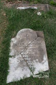
Photograph, Peter Pidgeon, Grave of Peter Lawlor and children, Eltham Cemetery, Victoria, 5 April 2021
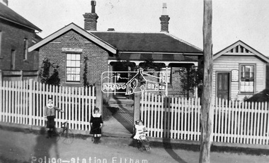
... In 1859 Peter and his wife Kate were able to move into an official police residence at the corner of Maria Street (now Main Road) and Brougham Street, with stables out the back and a large paddock for grazing across the road. Some of their children went to Eltham Primary School. ...In 1859 Peter and his wife Kate were able to move into an official police residence at the corner of Maria Street (now Main Road) and Brougham Street, with stables out the back and a large paddock for grazing across the road. Some of their children went to Eltham Primary School. ...The Victorian gold rush came to Eltham in the early 1850s and with it came a crime wave. Local traders called for police protection. This led to the appointment in 1857 of Irish-born Peter Lawlor as Senior Constable at Eltham. In 1859 Peter and his wife Kate were able to move into an official police residence at the corner of Maria Street (now Main Road) and Brougham Street, with stables out the back and a large paddock for grazing across the road. Some of their children went to Eltham Primary School. That 1859 police residence is now the home of the Eltham District Historical Society. The small wooden building on the very corner is a modern replica of the separate police station/office built around 1885-1900. Cases investigated by Constable Lawlor included murders, stealing (horses, cattle, fowls, watches, linen, clothing), a search for a missing person, and two separate instances of abandoned children seeking help. He was officially commended in 1866 for bringing to justice a man who had indecently assaulted an 11-year old girl. Sadly, there was a similar but unconnected case only a few months later. But events had a lighter side; in 1871 Kate lent her piano to the Snowflakes Christy Minstrels for a Catholic Church fund-raising concert. Peter was transferred to Prahran in 1872. He died in 1876 and is buried in Eltham Cemetery with four of his children. His headstone was stolen some time after May 1990 but was returned anonymously (broken into three pieces) in August 2013. It is resting on his grave but has not been re-erected. The Inscription reads: Peter Lawlor Who died February 12th 1876 Aged 55 years Also his children Michael Margaret Maud and EdithBorn Digitaleltham cemetery, gravestones, edith lawlor, margaret lawlor, maud lawlor, michael lawlor, peter lawlor -
 Eltham District Historical Society Inc
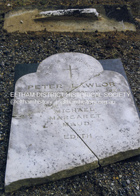
Photograph, Harry Gilham, Grave of Peter Lawlor and children, Eltham Cemetery, Victoria, 2016
... In 1859 Peter and his wife Kate were able to move into an official police residence at the corner of Maria Street (now Main Road) and Brougham Street, with stables out the back and a large paddock for grazing across the road. Some of their children went to Eltham Primary School. ...In 1859 Peter and his wife Kate were able to move into an official police residence at the corner of Maria Street (now Main Road) and Brougham Street, with stables out the back and a large paddock for grazing across the road. Some of their children went to Eltham Primary School. ...Grave of Peter Lawlor, Eltham's 1st policeman. Gravestone was borrowed from the cemetery & returned many years later. This photo was taken shortly after the (broken) stone was returned to Eltham Cemetery after 20 odd years absence. The Victorian gold rush came to Eltham in the early 1850s and with it came a crime wave. Local traders called for police protection. This led to the appointment in 1857 of Irish-born Peter Lawlor as Senior Constable at Eltham. In 1859 Peter and his wife Kate were able to move into an official police residence at the corner of Maria Street (now Main Road) and Brougham Street, with stables out the back and a large paddock for grazing across the road. Some of their children went to Eltham Primary School. That 1859 police residence is now the home of the Eltham District Historical Society. The small wooden building on the very corner is a modern replica of the separate police station/office built around 1885-1900. Cases investigated by Constable Lawlor included murders, stealing (horses, cattle, fowls, watches, linen, clothing), a search for a missing person, and two separate instances of abandoned children seeking help. He was officially commended in 1866 for bringing to justice a man who had indecently assaulted an 11-year old girl. Sadly, there was a similar but unconnected case only a few months later. But events had a lighter side; in 1871 Kate lent her piano to the Snowflakes Christy Minstrels for a Catholic Church fund-raising concert. Peter was transferred to Prahran in 1872. He died in 1876 and is buried in Eltham Cemetery with four of his children. His headstone was stolen some time after May 1990 but was returned anonymously (broken into three pieces) in August 2013. It is resting on his grave but has not been re-erected. The Inscription reads: Peter Lawlor Who died February 12th 1876 Aged 55 years Also his children Michael Margaret Maud and EdithColour print 21 x 15 cmeltham cemetery, gravestones, edith lawlor, margaret lawlor, maud lawlor, michael lawlor, peter lawlor -
 Eltham District Historical Society Inc
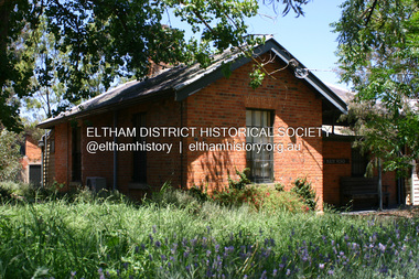
Photograph - Digital Photograph, Alan King, Former Police Residence, 728 Main Road, Eltham, 28 December 2007
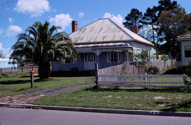
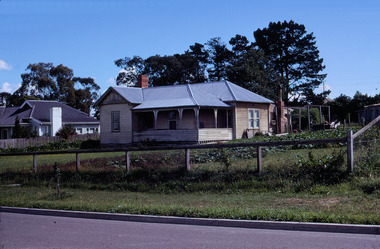
... At times the horse would be grazed on the paddocks across the road. Horseshoes were forged by the blacksmith beside the Courthouse on the high side of “Policeman’s Hill”. ...At times the horse would be grazed on the paddocks across the road. Horseshoes were forged by the blacksmith beside the Courthouse on the high side of “Policeman’s Hill”. ...The institutions of law and order in Colonial Victoria included the police, courts and prisons. The 1852 report of the Snodgrass Select Committee appointed to "identify the policing needs of the colony” noted there existed seven independent police forces that did not co-operate or regularly communicate. Following the committee's report all these police entities were merged into the Victoria Police, founded on 8 January 1853, to implement law and order responsibilities throughout the Colony of Victoria. The Eltham Courthouse (1860) and adjacent Police Residence (1859) formed a justice precinct established in the immediate aftermath of the 1852 police inquiry and the effects of the gold rush. The physical presence of these buildings, in the centre of the early Eltham township, defined centralised control over law and order. In the early days the Police Constable in charge would conduct his duties travelling around the district by horse; a stable was located at the rear of the residence. At times the horse would be grazed on the paddocks across the road. Horseshoes were forged by the blacksmith beside the Courthouse on the high side of “Policeman’s Hill”. Along with the stable, there was a two-cell bluestone lockup where prisoners were held awaiting trial in the adjacent Courthouse. Their meals were usually provided by the policeman’s wife or from the hotel just up the road. With the arrival of the railway in 1902 the town centre gradually shifted towards the railway station. The Police Station and operations were moved into the town centre in 1961 to a renovated house in Pryor Street, which was later replaced by the current Police Station. From 1961-1981 the residence was occupied by the Vermin and Noxious Weeds Destruction Section of the Department of Crown Lands and Survey. Prior to August 1967 the former Police Station was dragged to the rear of Police Residence to make way for the construction of a driveway and access from Main Road. The building was placed on the site of a former Scullery and modified for Lands Department use. In 1981 the Shire of Eltham took over management of the former Police Residence in Eltham. It remained unoccupied for a period whilst its future was discussed in Council. It was then used for a community job creation scheme until 1985. In 1985 the Shire of Eltham Parks and Environment occupied the residence. Council improved the driveway but later added a second rear access from Brougham Street due to the dangerous nature of the Main Road entrance. Additionally, a rear toilet facility between the Police Residence and the relocated former Police Station, which was doubling up as a lunchroom. Council also commenced discussions to re-establish a replica Police Station. Around November 1986 the former Police Station was demolished; believed to have been suffering termite damage. About 1989, after some years of discussion, a replica Police Station was built, based on photographs, to act as a lunchroom and meeting room for the Parks and Environment staff and volunteers doing community service. In 1996 Eltham District Historical Society held discussions with Nillumbik Shire Council commissioners throughout the year regarding a home for the Society. A proposal was put forward by the Society in October to occupy the former Police Residence. In March 1997 Eltham District Historical Society gained access to former Police Residence and on July 12, 1998, moved into its Local History Centre. In July 2018, Eltham District Historical Society gained access to the replica Police Station (which had been used as a music library and storage for the Eltham Concert Band) for use as part of regular heritage tours for schools and community-based groups. Covered under Heritage Overlay, Nillumbik Planning Scheme. Published: Nillumbik Now and Then / Marguerite Marshall 2008; photographs Alan King with Marguerite Marshall.; p65This collection of almost 130 photos about places and people within the Shire of Nillumbik, an urban and rural municipality in Melbourne's north, contributes to an understanding of the history of the Shire. Published in 2008 immediately prior to the Black Saturday bushfires of February 7, 2009, it documents sites that were impacted, and in some cases destroyed by the fires. It includes photographs taken especially for the publication, creating a unique time capsule representing the Shire in the early 21st century. It remains the most recent comprehenesive publication devoted to the Shire's history connecting local residents to the past. nillumbik now and then (marshall-king) collection, eltham, main road, eltham district historical society, eltham justice precinct, little eltham, local history centre, police residence, police station -
 Eltham District Historical Society Inc
Photograph, Tom Prior, Police Station and Residence, Maria Street, Eltham, c.1900
... At times the horse would be grazed on the paddocks across the road. Horseshoes were forged by the blacksmith beside the Courthouse on the high side of “Policeman’s Hill”. ...At times the horse would be grazed on the paddocks across the road. Horseshoes were forged by the blacksmith beside the Courthouse on the high side of “Policeman’s Hill”. ...Situated near the top of what was known as 'Policeman's Hill' according to Miss Ivy Reynolds, neice of the photographer, Tom Prior. From the left, Eltham Court House, Police Residence and Police station on Main Road and corner of Brougham Street. These buildings formed part of Little Eltham and still stand (without the front fence) today though the Police Station was demolished in 1986 due to termite damage. A replica was built circa 1989. The institutions of law and order in Colonial Victoria included the police, courts and prisons. The 1852 report of the Snodgrass Select Committee appointed to "identify the policing needs of the colony” noted there existed seven independent police forces that did not co-operate or regularly communicate. Following the committee's report all these police entities were merged into the Victoria Police, founded on 8 January 1853, to implement law and order responsibilities throughout the Colony of Victoria. The Eltham Courthouse (1860) and adjacent Police Residence (1859) formed a justice precinct established in the immediate aftermath of the 1852 police inquiry and the effects of the gold rush. The physical presence of these buildings, in the centre of the early Eltham township, defined centralised control over law and order. In the early days the Police Constable in charge would conduct his duties travelling around the district by horse; a stable was located at the rear of the residence. At times the horse would be grazed on the paddocks across the road. Horseshoes were forged by the blacksmith beside the Courthouse on the high side of “Policeman’s Hill”. Along with the stable, there was a two-cell bluestone lockup where prisoners were held awaiting trial in the adjacent Courthouse. Their meals were usually provided by the policeman’s wife or from the hotel just up the road. With the arrival of the railway in 1902 the town centre gradually shifted towards the railway station. The Police Station and operations were moved into the town centre in 1961 to a renovated house in Pryor Street, which was later replaced by the current Police Station. From 1961-1981 the residence was occupied by the Vermin and Noxious Weeds Destruction Section of the Department of Crown Lands and Survey. Prior to August 1967 the former Police Station was dragged to the rear of Police Residence to make way for the construction of a driveway and access from Main Road. The building was placed on the site of a former Scullery and modified for Lands Department use. In 1981 the Shire of Eltham took over management of the former Police Residence in Eltham. It remained unoccupied for a period whilst its future was discussed in Council. It was then used for a community job creation scheme until 1985. In 1985 the Shire of Eltham Parks and Environment occupied the residence. Council improved the driveway but later added a second rear access from Brougham Street due to the dangerous nature of the Main Road entrance. Additionally, a rear toilet facility between the Police Residence and the relocated former Police Station, which was doubling up as a lunchroom. Council also commenced discussions to re-establish a replica Police Station. Around November 1986 the former Police Station was demolished; believed to have been suffering termite damage. About 1989, after some years of discussion, a replica Police Station was built, based on photographs, to act as a lunchroom and meeting room for the Parks and Environment staff and volunteers doing community service. In 1996 Eltham District Historical Society held discussions with Nillumbik Shire Council commissioners throughout the year regarding a home for the Society. A proposal was put forward by the Society in October to occupy the former Police Residence. In March 1997 Eltham District Historical Society gained access to former Police Residence and on July 12, 1998, moved into its Local History Centre. In July 2018, Eltham District Historical Society gained access to the replica Police Station (which had been used as a music library and storage for the Eltham Concert Band) for use as part of regular heritage tours for schools and community-based groups.This photo forms part of a collection of photographs gathered by the Shire of Eltham for their centenary project book,"Pioneers and Painters: 100 years of the Shire of Eltham" by Alan Marshall (1971). The collection of over 500 images is held in partnership between Eltham District Historical Society and Yarra Plenty Regional Library (Eltham Library) and is now formally known as 'The Shire of Eltham Pioneers Photograph Collection.' It is significant in being the first community sourced collection representing the places and people of the Shire's first one hundred years. The Reynolds family were early settlers in Research. The Reynolds/ Prior collection of photographs were taken by Tom Prior, the maternal uncle of Ivy Reynolds, around 1900 and the 60 photos in the album give a fine overview of many of the landmarks of Research and Eltham over 100 years ago. lvy lived in the family home for many years at 106 Thompson Cres Research. Ivy's father, Ernst Richard Reynolds and grandfather, Richard Reynolds, lived at the same address. Ivy's father Richard worked for Mr. Trail on his property in Research. Reynolds Road is named after the family. Mr Tom Prior (wife Eva) worked at the Melbourne zoo. He was very innovative and made his own camera, using the black cloth hood to exclude the light. The photographs are a reminder of the rural nature of Research and Eltham and its rich heritage.Digital imagechildren, court house, courthouse, eltham, eltham district historical society, eltham justice precinct, little eltham, local history centre, main road, police residence, police station, reynolds prior collection, sepp, shadow, shire of eltham pioneers photograph collection -
 Ringwood and District Historical Society
Photograph, North side of City Road, Ringwood 1969
... Both paddocks were developed in about 1961/62, and there are about 12 houses there now, plus the Lutheran Church. When we first moved there, there was a horse and a cow grazing in the paddock beside our house. ...Both paddocks were developed in about 1961/62, and there are about 12 houses there now, plus the Lutheran Church. When we first moved there, there was a horse and a cow grazing in the paddock beside our house. ...Written by Michael Anderson on RDHS Facebook on March 2016 CITY ROAD, RINGWOOD 1959 My family moved to City Road in 1959. At that time, it was a narrow rutted dirt road, with a large drain running on the northern side, and a wide nature strip complete with big wattle trees on the southern side, ideal for playing cricket and other games. There was no Salvation Army Citadel, nor was there a Lutheran Church. As you proceed from Wantirna Road towards Jubilee Park, there were no houses on the right hand side at all until you reached our house, 14 City Road, which at the time was Lot 51. On the corner where the Lutheran Church now stands, there was an old rusty farm gate, attached to a very weathered wooden post. This indicated that at some stage, City Road had been a private road. This rusty old gate was never closed, but it was a remnant of bygone days. Ireland St, Regina St, and Greenwood Avenue south of Haig Street were all narrow dirt roads as well. Jubilee Park Oval was fairly new, and there was no grandstand. The players and staff had to make do with a small wooden building that looked like a garden shed. Just beyond the southern end of the oval were growing many wild pumpkins, and I understand that the land had been a rubbish tip in the not so distant past. The park also had a couple of tennis courts. There was no road from Jubilee Park to Reilly St, and Reilly St didn't go all the way through from Wantirna Road to Great Ryrie St. It was broken by a creek. Aquinas College was an orchard. As you proceed up City Road from Wantirna Road, The Salvation Army church is on the left corner. The Hobbs family lived on that corner, in an old house on a block which was bordered by a huge hedge. The house next door in Wantirna Road, which is also Salvation Army land now, was owned by the Bayliss family. Mrs Bayliss was a teacher at Ringwood High. The first house in City Rd proper was at no. 1 to 5. The Roberts family lived there in an old weatherboard house on an acre of land. Mr Roberts was a carpenter who had built our house at No. 14, and he lived there with his wife and two sons, Graeme and Max. Eventually, they wanted more space, so they moved to the acre. Next door to the Roberts was Ted O'Regan at no. 7 to no. 9. He appears to have been a widower, and he lived by himself in an old wooden house which was surrounded by a large veranda on about 2/3 acre. Next door to Ted O'Regan lived his brother Jack O'Regan at no. 11 on about 1/2 acre, with his wife Edna, his son Alan, and his Daughter Judith. Barney Meadows lived on about 1/2 acre at no. 13. Barney was an old widower, and his front garden had a huge palm tree in it. Next to Barney lived the Reeves at no. 15, and finally there was the McDonald family at no. 17, which is on the corner of Regina St. From then on, City Rd, was a bush block down to Greenwood Ave, and the bush continued up Greenwood Ave to the Williams house, one house block from Haig St. On the right hand side of City Road it was all paddock to Ireland St, and another paddock which ended at our house was over the other side of Ireland St. Both paddocks were developed in about 1961/62, and there are about 12 houses there now, plus the Lutheran Church. When we first moved there, there was a horse and a cow grazing in the paddock beside our house. For the first couple of years, there was a huge bonfire in "our" paddock to mark Guy Fawkes day. It was a lot of fun, although I concede that it might have been a tad dangerous, with 3d. bungers and all that! Next door to us at no. 16 was the Goessling family. From now on the house blocks were normal sized. The Goesslings had one baby girl who was about 9 months old when we first moved in, but they ended up with 4 kids, all of whom would be middle aged now. They were observant Lutherans, but they were there before the church. Next door to the Goesslings at no. 18 was the Weir family on the corner of Regina St. On the other side of Regina St. at no. 20 was the Gowland family, and the last house in the street at no. 22 was owned by Arthur Johnston and his family. Arthur was an Ambulance Driver. Of course, many other people moved in and moved out in all those years. There was one particularly bad week for the street in June 1969. My brother Peter was killed in a work accident on Saturday 7th June. The next Wednesday 11th June Ted O'Regan, who lived diagonally opposite us died. Then on the next Saturday the 14th June, Ted Bell, who lived next door to us at no. 12 died from a heart attack at the age of 47. Three deaths in one week was a bit too much. It was eerie! Our old house is still standing, but I doubt for much longer. It was bought by people who wanted to develop it. Their plans were knocked back, so they sold it again. I would bet that in the not too distant future the house will be a piece of history. City Road was a paradise for kids when we moved in. We had lived in the inner suburbs, so the space and freedom were amazing for us "city slickers." I don't know where you could move to now if you wanted to bring up your children in a similar environment. Somehow, I don't think it would be possible. -
 Ringwood and District Historical Society
Photograph, City Road – North Side. Owned by E A (Ted) O’Regan on 23 March 1969
... Both paddocks were developed in about 1961/62, and there are about 12 houses there now, plus the Lutheran Church. When we first moved there, there was a horse and a cow grazing in the paddock beside our house. ...Both paddocks were developed in about 1961/62, and there are about 12 houses there now, plus the Lutheran Church. When we first moved there, there was a horse and a cow grazing in the paddock beside our house. ...Written by Michael Anderson on RDHS Facebook on March 2016 CITY ROAD, RINGWOOD 1959 My family moved to City Road in 1959. At that time, it was a narrow rutted dirt road, with a large drain running on the northern side, and a wide nature strip complete with big wattle trees on the southern side, ideal for playing cricket and other games. There was no Salvation Army Citadel, nor was there a Lutheran Church. As you proceed from Wantirna Road towards Jubilee Park, there were no houses on the right hand side at all until you reached our house, 14 City Road, which at the time was Lot 51. On the corner where the Lutheran Church now stands, there was an old rusty farm gate, attached to a very weathered wooden post. This indicated that at some stage, City Road had been a private road. This rusty old gate was never closed, but it was a remnant of bygone days. Ireland St, Regina St, and Greenwood Avenue south of Haig Street were all narrow dirt roads as well. Jubilee Park Oval was fairly new, and there was no grandstand. The players and staff had to make do with a small wooden building that looked like a garden shed. Just beyond the southern end of the oval were growing many wild pumpkins, and I understand that the land had been a rubbish tip in the not so distant past. The park also had a couple of tennis courts. There was no road from Jubilee Park to Reilly St, and Reilly St didn't go all the way through from Wantirna Road to Great Ryrie St. It was broken by a creek. Aquinas College was an orchard. As you proceed up City Road from Wantirna Road, The Salvation Army church is on the left corner. The Hobbs family lived on that corner, in an old house on a block which was bordered by a huge hedge. The house next door in Wantirna Road, which is also Salvation Army land now, was owned by the Bayliss family. Mrs Bayliss was a teacher at Ringwood High. The first house in City Rd proper was at no. 1 to 5. The Roberts family lived there in an old weatherboard house on an acre of land. Mr Roberts was a carpenter who had built our house at No. 14, and he lived there with his wife and two sons, Graeme and Max. Eventually, they wanted more space, so they moved to the acre. Next door to the Roberts was Ted O'Regan at no. 7 to no. 9. He appears to have been a widower, and he lived by himself in an old wooden house which was surrounded by a large veranda on about 2/3 acre. Next door to Ted O'Regan lived his brother Jack O'Regan at no. 11 on about 1/2 acre, with his wife Edna, his son Alan, and his Daughter Judith. Barney Meadows lived on about 1/2 acre at no. 13. Barney was an old widower, and his front garden had a huge palm tree in it. Next to Barney lived the Reeves at no. 15, and finally there was the McDonald family at no. 17, which is on the corner of Regina St. From then on, City Rd, was a bush block down to Greenwood Ave, and the bush continued up Greenwood Ave to the Williams house, one house block from Haig St. On the right hand side of City Road it was all paddock to Ireland St, and another paddock which ended at our house was over the other side of Ireland St. Both paddocks were developed in about 1961/62, and there are about 12 houses there now, plus the Lutheran Church. When we first moved there, there was a horse and a cow grazing in the paddock beside our house. For the first couple of years, there was a huge bonfire in "our" paddock to mark Guy Fawkes day. It was a lot of fun, although I concede that it might have been a tad dangerous, with 3d. bungers and all that! Next door to us at no. 16 was the Goessling family. From now on the house blocks were normal sized. The Goesslings had one baby girl who was about 9 months old when we first moved in, but they ended up with 4 kids, all of whom would be middle aged now. They were observant Lutherans, but they were there before the church. Next door to the Goesslings at no. 18 was the Weir family on the corner of Regina St. On the other side of Regina St. at no. 20 was the Gowland family, and the last house in the street at no. 22 was owned by Arthur Johnston and his family. Arthur was an Ambulance Driver. Of course, many other people moved in and moved out in all those years. There was one particularly bad week for the street in June 1969. My brother Peter was killed in a work accident on Saturday 7th June. The next Wednesday 11th June Ted O'Regan, who lived diagonally opposite us died. Then on the next Saturday the 14th June, Ted Bell, who lived next door to us at no. 12 died from a heart attack at the age of 47. Three deaths in one week was a bit too much. It was eerie! Our old house is still standing, but I doubt for much longer. It was bought by people who wanted to develop it. Their plans were knocked back, so they sold it again. I would bet that in the not too distant future the house will be a piece of history. City Road was a paradise for kids when we moved in. We had lived in the inner suburbs, so the space and freedom were amazing for us "city slickers." I don't know where you could move to now if you wanted to bring up your children in a similar environment. Somehow, I don't think it would be possible. -
 Kiewa Valley Historical Society
Folder - Kiewa Methodist Church, 1917 to 1962
... It was used by the three Protestant Groups and maintenance was paid for by an annual area collection.The house on the west side was a Presbyterian Manse for many years and the block of ground on the north side was known as the Manse paddock in which the minister grazed his cow and horse." In 1936 there was a fence between the Kiewa Methodist Church was the Presbyterian Church in Kiewa. ...It was used by the three Protestant Groups and maintenance was paid for by an annual area collection.The house on the west side was a Presbyterian Manse for many years and the block of ground on the north side was known as the Manse paddock in which the minister grazed his cow and horse." In 1936 there was a fence between the Kiewa Methodist Church was the Presbyterian Church in Kiewa. ...The copy of a letter written by Harry H. Simmonds of Huon notes that "the church existed in 1905. It was built by Hill and McCormack with timber donated by Mr Ned Dunstan on ground donated by Mr James Thomas probably in the late 1800s. It was possibly called a Methodist Church because the donor of the land was a Methodist. It was used by the three Protestant Groups and maintenance was paid for by an annual area collection.The house on the west side was a Presbyterian Manse for many years and the block of ground on the north side was known as the Manse paddock in which the minister grazed his cow and horse." In 1936 there was a fence between the Kiewa Methodist Church was the Presbyterian Church in Kiewa. Its Certificate of Title is Volume 5134 Folio 1026783 (Sept. 1942.) In 1952, the church was made of wood with an iron roof. In 1954. Request to Yackandandah Shire re a fence from Kiewa Consolidated School entrance to the unused hedge adjacent to the Church. In 1958 there was correspondence re 'the strip of land on each side of the Church.' Churches were an important part of life during the late 19th century and early to mid 20th century and were built in the centre of town as was this one. These papers give an understanding of the work involved in maintaining a church. The letters and 'book' give a lot of names of local families involved with the Methodist Church at Kiewa. Yellow plastic spiral folder with 18 pages enclosed in clear plastic sleeves.Papers enclosed include accounts, payments, tenders and other correspondence relating to the Methodist Church at Kiewa dating from 1932 to 1962. Of particular interest is a black cardboard cover book dated 1917 re collection of donations from listed people. The latest date in the book is 1942.Enclosed in first plastic sleeve is a letter from the donor, Kathie Vines dated 15th July 2013methodist church; kiewa; harry h. simmonds; yackandandah council; -
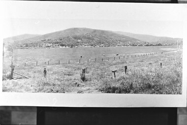
 Kiewa Valley Historical Society
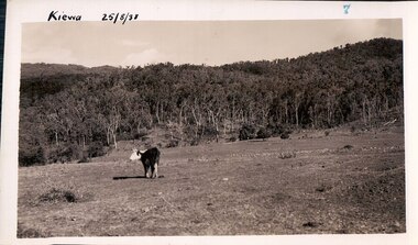
Black and white photograph of farmland, Kiewa, 25/8/38, circa 1938
... Black and white photograph of grazing farmland with one animal standing in the paddock. The area could possibly be where the golf course now stands with the road to the high plains not yet commenced....On the back are the words Velox repeated several times, indicating the type of photographic paper Black and white photograph of grazing farmland with one animal standing in the paddock. The area could possibly be where the golf course now stands with the road to the high plains not yet commenced. ...This photograph was taken in August, 1938, some eight years prior to the establishment of Mt. Beauty a a township. The area was still being used for grazing, and the land was eventually acquired from the local land owners by the State Electricity Commission. The construction of the road, from Tawonga to the High Plains, was commenced in April, 1938 and this photograph was taken August, 1938. This allowed men and heavy equipment to be transported to the work sites for the construction of the Kiewa Hydro Electric Scheme. Prior to this access was by bridle trail, either on horse back or on foot. By 1946 housing construction had commenced for the new town of Mt. Beauty and by 1948 street construction in the southern part of the town was completed as far as Hill Street.This photograph is important as it shows the upper Kiewa Valley as it was before the establishment of the town of Mt. Beauty. The land has been cleared of natural vegetation to allow grazing of cattle. Black and white photograph of grazing farmland with one animal standing in the paddock. The area could possibly be where the golf course now stands with the road to the high plains not yet commenced.Handwritten in the upper left hand corner 'Kiewa 25/8/38'. The number 7 has been stamped in the upper right hand corner. It is part of a set of 8 photographs. On the back are the words Velox repeated several times, indicating the type of photographic papergrazing, kiewa, mt. beauty, secv -
 Federation University Historical Collection
Photograph, James (Jim) Smith of Happy Valley
... grazing and the two houses fell into disrepair. In 1995 George's grandson Ernest (Alf) Alfred Watson visited the site and reported a wrought iron gate at the site and a mulberry tree near the site of his grandmother's family home. Bluestone blocks can still be seen in the paddocks...grazing and the two houses fell into disrepair. In 1995 George's grandson Ernest (Alf) Alfred Watson visited the site and reported a wrought iron gate at the site and a mulberry tree near the site of his grandmother's family home. Bluestone blocks can still be seen in the paddocks ...James (Jim) Smith, (died 03/08/1974, aged 93 years) established an orchard growing snow apples near in Happy Valley after returning from mining activities in South Africa. The orchard was called "Springdallah" and was beside the Linton/Happy Valley Road across from the old Happy Valley railway station. Jim was the son of George Henry Smith (18/12/1840 - 26/11/1903) and Emma Keys Smith born Keys (07/08/1842 - 28/08/1888). George and Emma left Liverpool with other unassisted immigrants on the "Bates Family" ship with baby Clara on 08/06/1863 arriving in Melbourne on 08/06/1863. George and Emma emigrated to Australia on the invitation of Emma's brother Edward Keys who owned a property near the school at Happy Valley on which there were two houses. Teddy offered George and Emma the smaller one to live in. When "Teddy" decided to go into hotel keeping George took over the 200 acres of his property and made it a pleasant orchard and garden called "Cress Green Gardens". George had various secretarial jobs - rate collector; paymaster at the mines; until he became Shire Secretary for the Shire of Grenville, whose centre was Linton and Government Auditor for Western Victoria (1894-1903), the means of transport being horse and buggy. Another son followed his father as Shire Secretary. George and Emma had 14 children, Emma dying giving birth to Emma Keys who lived for 16 months. George later married Annie Bolte with 2 more children being born. Annie later sold the property. The land was used for grazing and the two houses fell into disrepair. In 1995 George's grandson Ernest (Alf) Alfred Watson visited the site and reported a wrought iron gate at the site and a mulberry tree near the site of his grandmother's family home. Bluestone blocks can still be seen in the paddocks from the roadside. The child in the photograph is Phyllis Joy Smith, Jim's eldest daughter. Jim Smith was the brother of Clara Emma Yung nee Smith.Sepia photo of two men and a girl. One of them is Jim Smith who established on orchard at Happy Valley. He also went to South Africa - mining activities. The orchard is now part of Clarkesdale Bird Sanctuary located at 360 Linton-Piggoreet Rd, Linton, Vic. 3360. Verso: Jim Smith South Africa (Mining) Established orchard halfway near Linton and Happy Valley. Clara Emma's brother. jim smith, james smith, clara emma smith, happy valley, yendon, piggoreet, south africa, mining, orchard, edward keys, george henry smith, emma keys smith, clara emma yung, annie bolte, shire of grenville, clarkesdale bird sanctury