Showing 204 items matching "ground water"
-
 Federation University Historical Collection
Book, The Melbourne Technical College Hydraulic Engineering
... ...ground water...Barker Library (top floor) Mount Helen goldfields Hydraulic Engineering melbourne technical college rmit rex hollioake leakage aquaducts dams spillways ground water pumping curvss pipes reservoirs tanks weir channel water supply sewerage sewers sewerage treatment drainage Two volumes of course notes for the course of Hydraulic Engineering at the Melbourne Technical College The Melbourne Technical College Hydraulic Engineering Book ...Two volumes of course notes for the course of Hydraulic Engineering at the Melbourne Technical Collegehydraulic engineering, melbourne technical college, rmit, rex hollioake, leakage, aquaducts, dams, spillways, ground water, pumping, curvss, pipes, reservoirs, tanks, weir, channel, water supply, sewerage, sewers, sewerage treatment, drainage -
 Bendigo Historical Society Inc.
Letter - KANGAROO FLAT GOLD MINE COLLECTION: FILE RECORD RE CENTRAL DEBORAH TOURIST MINE STUDY, 3rd August 1983
... ... ground water...History House 11 Mackenzie Street Bendigo goldfields BENDIGO Gold mining central deborah gold mine Central Deborah Gold Mine dewatering ground water mining Bendigo Mining NL File memo, from D.F. ...File memo, from D.F. Evans, 3 August, 1983 re Central Deborah Tourist Mine Study, discussing the report from John Reynolds now lodged in the Preston Library. Main aspects of concern in report to Bendigo Mining NL are: 1. Proposal to redevelop shaft and establish tourist access 2. Calculation of volume of water in old flooded workings in North Deborah, Deborah, South Deborah and Deborah No. 2 mines 3. Volume of water involved in dewatering Central Deborah to 90m below the surface 4. Long term pumping reate required to control groundwater influx, estimated to be 90,500 gallons/day.bendigo, gold mining, central deborah gold mine, central deborah gold mine, dewatering, ground water, mining, bendigo mining nl -
 Ballarat Tramway Museum
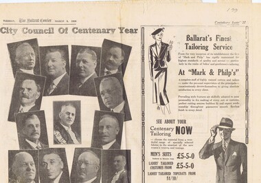
Newspaper, The Courier Ballarat, Courier, 8/3/1938 p21, 22, 29 & 30 - photo of Sturt St, Mar. 1938
... ... Sports Ground... Water...Trams tramways Ballarat Centenary Celebrations Centenary Sports Ground Water Supply Pages 21,22,29 and 30 of the Centenary issue of the Ballarat Courier, 8/3/1938. ...Yields information about Ballarat and its locations or environs late 1938.Pages 21,22,29 and 30 of the Centenary issue of the Ballarat Courier, 8/3/1938. Page 21 "When the World was Wide", photos, Ballaarat City Council of Centenary of settlement in the Ballarat district, year, and Sturt St. from Bridge St., possibly original photo of time. Ads. - Marks & Phillips, - Tailors and C.J.Coles. Page 22 - Towns that have a history - Learmonth, Clunes, Creswick and Buninyong. Photos - Learmonth, Clunes and Forestry school Creswick. Ads - State Savings Bank of Vic, Swanston Used Cars. Page 29 - Ballarat's historic Sports Grounds - origin and development, Eastern Oval incident, listing of nuggets found and quartz specimens. Ads for Prestige stockings, T&G Mutual Life and Fosters Lager. Photo of mine at No. 6 shaft on Band of Hope and Albion Consolidated. Page 30 - articles - Ballarat's sporting origins and swamp to reservoir (water supply). Photos of First England Cricket team to visit Ballarat and aqueduct at Kirks storage basin. Ads for Craig Bros, Pratts cash stores, Haymes paints and Ballarat Block Arcade - shops. Record reviewed and images of some of the pages added 10-9-2013trams, tramways, ballarat centenary celebrations, centenary, sports ground, water supply -
Glenelg Shire Council Cultural Collection
Slide - Slide - Construction Portland/Cashmore Airport, c. 1980
... Large diameter pipe embedded horizontally in ground. Water gushing out end of pipe....Large diameter pipe embedded horizontally in ground. Water gushing out end of pipe. Slide Slide - Construction Portland/Cashmore Airport ...Coloured slide. Large diameter pipe embedded horizontally in ground. Water gushing out end of pipe. -
 Kiewa Valley Historical Society
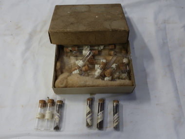
Sample Tubes
... Part of Geological investigation into the characteristics of the rock formations and ground water....Kiewa Valley Historical Society Mount Beauty Information Centre 31 Bogong High Plains Rd Mt Beauty high-country Part of Geological investigation into the characteristics of the rock formations and ground water. Water supply and infrastructure requires prior investigation before construction work can commence. ...Part of Geological investigation into the characteristics of the rock formations and ground water.Water supply and infrastructure requires prior investigation before construction work can commence.Very small glass tubes (about 30) with cork toppers. Each tube is labelled. Resting on wool in a cardboard box with a lid. Stored in an old thick cardboard box with a very faint 'Harrietville ... Samples' on its lid.On the tubes - place and number "Harrietville / samples"geological samples, harrietville water -
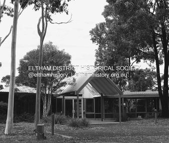
 Eltham District Historical Society Inc
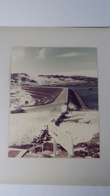
Negative - Photograph, Water treatment plant at Kangaroo Ground end of Maroondah Aqueduct tunnel, 1991
... Water treatment plant at Kangaroo Ground end of Maroondah Aqueduct tunnel...Ground...Maroondah Aqueduct...Water...Eltham District Historical Society Inc 728 Main Rd Eltham melbourne Kangaroo Ground Maroondah Aqueduct Water treatment plant Fuji HG 200 CA-1 Roll of 35mm colour negative film, 9 strips Colour print 10 x 15 cm Water treatment plant at Kangaroo Ground end of Maroondah Aqueduct tunnel Negative Photograph ...Roll of 35mm colour negative film, 9 strips Colour print 10 x 15 cmFuji HG 200 CA-1kangaroo ground, maroondah aqueduct, water treatment plant -
 Eltham District Historical Society Inc
Negative - Photograph, Water treatment plant at Kangaroo Ground end of Maroondah Aqueduct tunnel, 1991
... Water treatment plant at Kangaroo Ground end of Maroondah Aqueduct tunnel...Ground...Maroondah Aqueduct...Water...Eltham District Historical Society Inc 728 Main Rd Eltham melbourne Kangaroo Ground Maroondah Aqueduct Water treatment plant Fuji HG 200 CA-1 Roll of 35mm colour negative film, 9 strips Colour print 10 x 15 cm Water treatment plant at Kangaroo Ground end of Maroondah Aqueduct tunnel Negative Photograph ...Roll of 35mm colour negative film, 9 strips Colour print 10 x 15 cmFuji HG 200 CA-1kangaroo ground, maroondah aqueduct, water treatment plant -
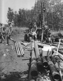 National Vietnam Veterans Museum (NVVM)
Photograph, Gibbons, Denis, Boring For Water
... The Engineers prepared to install sealed water pipes to carry ground water to the base water purification works, already under construction. ...The Engineers prepared to install sealed water pipes to carry ground water to the base water purification works, already under construction. ...Denis Gibbons (1937 – 2011) Trained with the Australian Army, before travelling to Vietnam in January 1966, Denis stayed with the 1st Australian Task Force in Nui Dat working as a photographer. For almost five years Gibbons toured with nine Australian infantry battalions, posting compelling war images from within many combat zones before being flown out in late November 1970 after sustaining injuries. The images held within the National Vietnam Veterans Museum make up the Gibbons Collection.A black and white photograph of the drilling for water at the 1st Australian Task Force Base, Nui Dat, Phouc tuy Province. The Engineers prepared to install sealed water pipes to carry ground water to the base water purification works, already under construction. (Circa November 1966)photograph, 1st atf base, engineers, 17 const sqn, nui dat, phuoc tuy province, gibbons collection catalogue, denis gibbons, photographer, vietnam war -
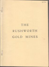 Bendigo Historical Society Inc.
Booklet - Rushworth Gold Mines
... The Rushworth gold rush began in 1853 and ended in 1870 when rising ground water made it unprofitable. The area then turned to the timber industries until the 1940's. ...History House 11 Mackenzie Street Bendigo goldfields The Rushworth gold rush began in 1853 and ended in 1870 when rising ground water made it unprofitable. The area then turned to the timber industries until the 1940's. ...The Rushworth gold rush began in 1853 and ended in 1870 when rising ground water made it unprofitable. The area then turned to the timber industries until the 1940's. It is estimated that the Rushworth goldfields produced approximately 100,000 ounces of gold.51-page soft cover booklet. Pale yellow covers. 'The Rushworth Gold Mines' A descriptive narrative of the Rushworth Gold Mines as prepared by the staff of the 'Rushworth Chronicle' and published in that journal in 1918. Mines are listed by name. rushworth, gold mines -
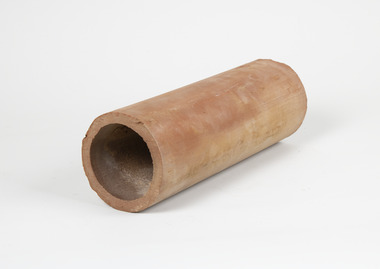 Merbein District Historical Society
Tool - Aggie pipe
... with early in precise furrow irrigation ground water mounds developed on blocks which were detrimental to vine growth Aggie pipes were laid on grade on the clay layer of soil 4 to 5 foot deep or every 4th row of vines (forty four feet apart) to drain the perched water table and the accumulated salts from the vines root zone ...Merbein District Historical Society 36 Box St Merbein the-murray with early in precise furrow irrigation ground water mounds developed on blocks which were detrimental to vine growth Aggie pipes were laid on grade on the clay layer of soil 4 to 5 foot deep or every 4th row of vines (forty four feet apart) to drain the perched water table and the accumulated salts from the vines root zone with early in precise furrow irrigation ground water mounds developed on blocks which were detrimental to vine growth Aggie pipes were laid on grade on the clay layer of soil 4 to 5 foot deep or every 4th row of vines (forty four feet apart) to drain the perched water table and the accumulated salts from the vines root zone horticulture merbein irrigation pipes furrow irrigation Long clay cylinder Tool Aggie pipe ...with early in precise furrow irrigation ground water mounds developed on blocks which were detrimental to vine growth Aggie pipes were laid on grade on the clay layer of soil 4 to 5 foot deep or every 4th row of vines (forty four feet apart) to drain the perched water table and the accumulated salts from the vines root zone with early in precise furrow irrigation ground water mounds developed on blocks which were detrimental to vine growth Aggie pipes were laid on grade on the clay layer of soil 4 to 5 foot deep or every 4th row of vines (forty four feet apart) to drain the perched water table and the accumulated salts from the vines root zone Long clay cylinder horticulture, merbein, irrigation, pipes, furrow irrigation -
 Emerald Museum & Nobelius Heritage Park
Photograph - La Belle Water Trough, 21st Century
... This item is a colour photograph of a concrete water trough, standing on dry flat ground with a fence and then a paved road in the background. .... / The trough legs were buried well into the ground. / Water was pumped from underground by a hand / pump. / © 1930.".... / The trough legs were buried well into the ground. / Water was pumped from underground by a hand / pump. / © 1930." ...The trough pictured was erected outside of Tim Kennedy's La Belle guest house in Emerald, from at least the 1930s. It allowed travellers at the guest house to water their horses, with water pumped from underground with a hand pump. It was likely installed by Charles A'Vard. The photograph itself was produced in the 21st century.Water troughs like the one pictured were once available everywhere; the memory of this one is a memory of the time when much transport still occurred under horsepower.This item is a colour photograph of a concrete water trough, standing on dry flat ground with a fence and then a paved road in the background. The trough stands on six concrete legs, with a metal pipe emerging from the ground to follow the leftmost background leg to a semicircular upper concrete section at the leftmost end of the trough. Some elements of the trough have chipped away but it is mostly intact. The reverse of the printed photograph features regular FujiFilm logos and extensive annotation, handwritten in blue pen.Handwritten, reverse: "Original trough from outside "La Belle" guest / house owned by Tim Kennedy. He was a carrier / he had horses and lorry. / This trough was used by travellers to water their horses. There was also one at / Hermon's Corner Menzies Creek. (Main Rd & / Grantulla Rd.) / Charlie A'Vard worked on installing these for / Ard [?] Franklin who had a plumbers business in / Belgrave. / The trough legs were buried well into the ground. / Water was pumped from underground by a hand / pump. / © 1930."kennedy family, la belle guest house, transport, emerald, 1930s -
 Bendigo Historical Society Inc.
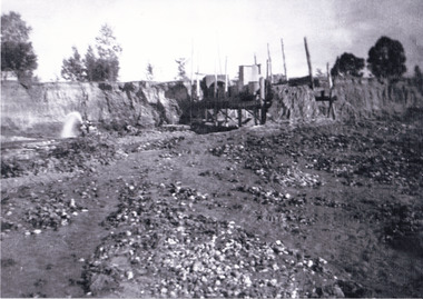
Document - CENTRAL DEBORAH GOLD MINE: TRUSTY TIMES, RISING WATER
... Three page stapled document titled 'Trusty Times' Issue 90, Special Edition July 2012, outlining the issues faced by the Central Deborah Gold Mine with rising ground water and its impact across the broader Bendigo mining area if a solution to the problem is not found. ...History House 11 Mackenzie Street Bendigo goldfields BHS Collection BENDIGO Mining central deborah gold mine Three page stapled document titled 'Trusty Times' Issue 90, Special Edition July 2012, outlining the issues faced by the Central Deborah Gold Mine with rising ground water and its impact across the broader Bendigo mining area if a solution to the problem is not found. ...BHS CollectionThree page stapled document titled 'Trusty Times' Issue 90, Special Edition July 2012, outlining the issues faced by the Central Deborah Gold Mine with rising ground water and its impact across the broader Bendigo mining area if a solution to the problem is not found. Photo on front of 'Trusty Times' shows Damian Drum, Tom Seddon, Peter Walsh and Jeff Rigby. Images on page 3 show the pumping equipment already installed.bendigo, mining, central deborah gold mine -
Port Melbourne Historical & Preservation Society
Photograph - COR/BP tank farm clean-up, Alison Kelly, Aug 1990
... Photos all looking south; views of equipment scooping out hydro-carbons, soil from pit filled with ground water; top to bottom: Williamstown and Webb Dock in background; white Toyota EAY-921 right foreground; close up; close up; Princes Pier in left background...Photos all looking south; views of equipment scooping out hydro-carbons, soil from pit filled with ground water; top to bottom: Williamstown and Webb Dock in background; white Toyota EAY-921 right foreground; close up; close up; Princes Pier in left background Photograph COR/BP tank farm clean-up Alison Kelly ...Shot when Alision Kelly was caretaker at the nearby 'Mission Art Centre' and displayed there and at the Port Melbourne LibraryFour colour photos of bulldozer working on clean up process on site of former COR/BP tank farm - view to south. Archivally mounted on vertical strip of white card and enclosed in mylar. Photos all looking south; views of equipment scooping out hydro-carbons, soil from pit filled with ground water; top to bottom: Williamstown and Webb Dock in background; white Toyota EAY-921 right foreground; close up; close up; Princes Pier in left backgroundInk on back: 'A. Kelly 645 2324'town planning - proposals shelved - bayside, environment, alison kelly -
 Bendigo Historical Society Inc.
Newspaper - Kangaroo Flat Gold Mine Collection: Latrobe University Bendigo
... Important research undertaken more recently at the University includes studies in ground water, palaeo-environmental studies, palaeo-magnetism and rock magnetism. ...Important research undertaken more recently at the University includes studies in ground water, palaeo-environmental studies, palaeo-magnetism and rock magnetism. ...Article, undated, name of paper not given, 'La Trobe to drop earth sciences'. Article discusses the demise of earth science degrees at La Trobe University Bendigo. La Trobe University 'is well known for its research on Australian granites, volcanic and metamorphic rocks'. Important research undertaken more recently at the University includes studies in ground water, palaeo-environmental studies, palaeo-magnetism and rock magnetism. Article on back of clipping 'Sleeping giant gets ready to roll' discusses the development of Newcrest's Mining's 'mothballed' Telfer Gold Mine in W.A.gold mining, bendigo, la trobe university, rock sciences, bachelor of science (rock sciences) -
 Greensborough Historical Society
Slide - Photograph, John Ramsdale, Run off into Plenty River: Slide 64, 1990s
... Photograph shows water over ground. This is run off into the Plenty River...Greensborough Historical Society 34A Glenauburn Road Lower Plenty Lower Plenty melbourne Photograph shows water over ground. This is run off into the Plenty River Part of the John Ramsdale collection of slides and audio visual material. plenty river No caption. ...Photograph shows water over ground. This is run off into the Plenty RiverPart of the John Ramsdale collection of slides and audio visual material.Colour photograph scanned from slide.No caption. Printed maker's mark on slide "Kodak Kodachrome Slide"plenty river -
 Greensborough Historical Society
Slide - Photograph, John Ramsdale, River flood plain looking west: Slide 67, 1990s
... Photograph shows a rural scene with water over ground. This is the Plenty River flood plain looking west, Yan Yean or Mernda...Greensborough Historical Society 34A Glenauburn Road Lower Plenty Lower Plenty melbourne Photograph shows a rural scene with water over ground. This is the Plenty River flood plain looking west, Yan Yean or Mernda Part of the John Ramsdale collection of slides and audio visual material. plenty river yan yean mernda No maker's marks. ...Photograph shows a rural scene with water over ground. This is the Plenty River flood plain looking west, Yan Yean or MerndaPart of the John Ramsdale collection of slides and audio visual material.Colour photograph scanned from slide.No maker's marks. No caption on slide.plenty river, yan yean, mernda -
Glenelg Shire Council Cultural Collection
Photograph - Photograph - Main Breakwater construction, Portland, Dec-96
... Large amounts of water on ground. Piece of equipment in background. ...Large amounts of water on ground. Piece of equipment in background. ...Port of Portland Authority ArchivesBack: Lady Bay Rain Dec 1996port of portland archives, main breakwater, construction, portland, harbour, harbour development -
 The Beechworth Burke Museum
Photograph, 1920-1950
... The manipulation of surface and ground water via race networks was well planned and recorded in detail by local mining surveyors. ...The manipulation of surface and ground water via race networks was well planned and recorded in detail by local mining surveyors. ...This image taken between 1920-1930 depicts open-cut hydraulic sluicing at the Three Mile Mine, located about five kilometres south of Beechworth. Alluvial, or surface, mining began on this site in the 1850s, but was soon replaced by hydraulic sluicing methods. By the start of 1880 it is estimated that nine hundred miles of water races had been cut though soil and rock in the Beechworth district. Hydraulic sluicing employs high pressure jets of water to blast away large areas of earth and wash it down to be run through a sluice box. Gold gets caught in the sluice and the remaining slurry is washed away. Large water quantities were required for hydraulic sluicing, and the long water races and deep tailraces that were constructed were considered great engineering feats. This method of mining is extremely effective, but causes significant environmental damage and impacts to waterways and agricultural operations. Miners at Beechworth built extensive networks of races and dams to secure reliable supplies of water on a scale far greater than elsewhere in Victoria. By the 1880s Beechworth's water barons continued to hold more than half of all the water right licences on issue and undertook sluicing operations on a massive scale. The manipulation of surface and ground water via race networks was well planned and recorded in detail by local mining surveyors. The maps that were created, combined with modern geo-spatial technologies, provide a vital key in understanding the great lengths to which miners went to capture and control critical water resources. Today, Three Mile mine is called Baarmutha. The Three Mile Mine was unproductive until 1865 when John Pund and three other miners secured a fifteen year license and constructed a water race from Upper Nine Mile Creek to Three Mile Creek. In the early twentieth century Pund & Co. averaged over one thousand ounces of gold per year from the mine. After Pund's death in 1915, GSG Amalgamated Co operated the site, continuing sluicing until 1950. This image of hydraulic sluicing methods shows the extent of water-works engineering in the landscape. This photograph has historic and research potential for understanding changes to the landscape, the evolution of mining methods, and the extensive construction, manipulation and management of water networks in the Beechworth district. Black and white rectangular photograph on matte paperReverse: 7597-1 / Sluice Mining / Copied from original on loan from Webb (Qld) / Donated Nov 2009 / Baarmutha Three Mile Mine c1920-1950 / Managed by the Plain Bros then Parkinsons / Current Location is: Beechworth Animal Shelter / used for Baarmuthaburke museum, beechworth museum, beechworth, gold fields, gold rush, victorian gold rush, hydraulic sluicing, spring creek, netwown falls, mining tunnels, water races, tailraces, gold ming history, colonial australia, australian gold rushes, mining technology, beechworth historic district, indigo gold trail, indigo shire, john pund, water manipulation, water engineering, three mile creek, three mile mine, water race, large-scale mining methods, historical mining construction, alluvial mining, mining environmental impacts, baarmutha, water barons -
 Sunshine and District Historical Society Incorporated
Administrative record - City of Sunshine - Commissioner Mr Alexander Alex George Gillon Collection 1976 - 1982 - Notice of ordinary meeting of the council 10th February 1981, City of Sunshine, 4th February 1981
... Albans Road Sunshine Fence Lot 20 Riverview Court Maribyrnong Above ground water tank Lots 2 & 5 Frederick Street Building over Council Property Ravenhall Street Braybrook...Albans Road Sunshine Fence Lot 20 Riverview Court Maribyrnong Above ground water tank Lots 2 & 5 Frederick Street Building over Council Property Ravenhall Street Braybrook Foolscap sized document. ...Olympic Games The Catholic Family Welfare Bureau emergency family accommodation 10 Dodd Street Braybrook Land Transfer Part of Omega Street Discontinued Proposed Land Transfer Former Right of Way off Station Road between Poole Street and Tulloch Street Proposed Land Transfer George Street Maidstone Proposed to Discontinue part of Charlotte Street South of Hall Street Kiosk Sunshine Swimming Pool Demise of Land Howard Kingham Lodge Industrial Tipping Agreements City of South Melbourne Proposed Technical School Keilor More Park Committee of Management Proposed Pavilion Larissa Reserve Cherry Crescent Pre-School / Child Care Centre Maribyrnong Senior Citizens' Club Randall Street Removal of Dwelling from 18 Bennett Street Sunshine West to 32 Dale Avenie Pascoe Vale Health Act Registrations Aycliffe Drive Infant Welfare Centre Billingham Road Bridge over Kororoit Creek Maribyrnong River Valley Flooding Planning Permit Application Radio Mast Beaver Street St. Albans Planning Permit Application Hairdressing Salon 62 Station Place Sunshine Planning Permit Application Service Premises Alterations and extensions 123 Rosamond Road Maidstone Planning Permit Application Detached House Lot 284 Orama Street Deer Park Planning Permit Application Erection of iron fence Lot 664 West Street Sunshine West Planning Permit Application Extension to existing building Lots 44 & 45 and Nos 3 & 5 Richards Street Maidstone Land Use Permit Apartment house and caretaker's residence 16 Ridley Street Albion Planning Permit Application Transport and storage depot 16 Carrington Drive Albion Planning Permit Application Hot Bread Kitchen 9 Commercial Street Maidstone Planning Permit Application Laundrette Lot 1 Main Road West St. Albans Planning Permit Application Warehouse (Cold Store) Lot 2 Emu Road Maidstone Planning Permit Application Extension to garden shop Highpoint West Rosamond Road Maribyrnong Planning Permit Application Access widening Ashley Street Footscray West Planning Permit Application Office alternations Sperry Vickers 169 Rosamond Road Maribyrnong Planning Permit Application Factory renovations Somerville Road South West corner of Tottenham Parade Brooklyn Planning Permit Application Factory Lot 12 McIntyre Road Sunshine North Planning Permit Application Retail plant nursery corner of McIntyre Road and Main Road East and Sunshine Avenue Proposed Telecom Western Radio Telephone Terminal Commonwealth Land Hampstead Road Maidstone Plan of Transfer and Consolidation A. T. Stead Frederick Road and Justin Road Plan of Transfer Lysaght Durham Chemical Company Somerville Road Tottenham Plan of Subdivision ETA Cranwell Street and Lacy Street Braybrook Consolidation of Title Railway Parade Sunshine Traffic Signals Furlong Road and St. Albans Road St. Albans Street Lighting Agreement with City of Footscray for Princess Highway between Tottenham Parade & Holmwood Road and Francis Street & McDonald Road M.M.B.W. Land abutting Collenso Street School Crossing Furlong Road between Austin Street and Browne Avenue St. Albans Trees in Duke Street Sunshine North Closure of Omar Street to through traffic Pennell Reserve roof replacement Building over Easement 6 Busch Street Sunshine North Location of Building Lot 335 Maxweld Street Ardeer Verandah installation Lot 479 Kardina Drive St. Albans Location of Building 26 Harrison Street Deer Park Permission to Erect Building Lot 138 Keynes Court Deer Park Location of Building 9 Dinnell Street Sunshine West Location of Building 9 Walker Place Braybrook Building over Easement 9 Larool Crescent Sunshine West Location of Building Lot 990 Mulhall Drive St. Albans Fire Separation within a Building 22 St. Albans Road Sunshine Fence Lot 20 Riverview Court Maribyrnong Above ground water tank Lots 2 & 5 Frederick Street Building over Council Property Ravenhall Street Braybrookolympic games, catholic family welfare bureau, dodd street, braybrook, omega street, sunshine, station road, poole street, tulloch street, deer park, george street, maidstone, charlotte street, hall street, sunshine west, sunshine swimming pool, kennedy street, howard kingham lodge, darnley street, more park committee of management, more park, esmond street, ardeer, st. albans, cherry crescent, maribyrnong senior citizens' club, randall street, maribyrnong, bennett street, aycliffe drive, billingham road, kororoit creek, maribyrnong river valley, maribyrnong river, beaver street, station place, rosamond road, orama street, west street, richards street, ridley street, albion, carrington drive, commercial street, main road west, emu road, highpoint west, ashley street, footscray west, perry vickers, somerville road, tottenham parade, mcintyre road, sunshine north, main road east, sunshine avenue, hampstead road, frederick road, justin road, tottenham, lysaght durham chemical company, eta, cranwell street, lacy street, railway parade, furlong road, st. albans road, princess highway, collenso street, austin street, browne avenue, duke street, omar street, pennell reserve, burke street, busch street, maxweld street, kardina drive, harrison street, keynes court, dinnell street, walker place, larool crescent, mulhall drive, riverview court, ravenhall street, larissa reserve -
 Sunshine and District Historical Society Incorporated
Administrative record - City of Sunshine - Commissioner Mr Alexander Alex George Gillon Collection 1976 - 1982 - Notice of ordinary meeting of the council 10th February 1981, City of Sunshine, 4th February 1981
... Albans Road Sunshine Fence Lot 20 Riverview Court Maribyrnong Above ground water tank Lots 2 & 5 Frederick Street Building over Council Property Ravenhall Street Braybrook...Albans Road Sunshine Fence Lot 20 Riverview Court Maribyrnong Above ground water tank Lots 2 & 5 Frederick Street Building over Council Property Ravenhall Street Braybrook Foolscap sized document. ...Olympic Games The Catholic Family Welfare Bureau emergency family accommodation 10 Dodd Street Braybrook Land Transfer Part of Omega Street Discontinued proposed Land Transfer Former Right of Way off Station Road between Poole Street and Tulloch Street Proposed Land Transfer George Street Maidstone Proposed to Discontinue part of Charlotte Street South of Hall Street Kiosk Sunshine Swimming Pool Demise of Land Howard Kingham Lodge Industrial Tipping Agreements City of South Melbourne Proposed Technical School Keilor More Park Committee of Management Proposed Pavilion Larissa Reserve Cherry Crescent Pre-School / Child Care Centre Maribyrnong Senior Citizens' Club Randall Street Removal of Dwelling from 18 Bennett Street Sunshine West to 32 Dale Avenie Pascoe Vale Health Act Registrations Aycliffe Drive Infant Welfare Centre Billingham Road Bridge over Kororoit Creek Maribyrnong River Valley Flooding Planning Permit Application Radio Mast Beaver Street St. Albans Planning Permit Application Hairdressing Salon 62 Station Place Sunshine Planning Permit Application Service Premises Alterations and extensions 123 Rosamond Road Maidstone Planning Permit Application Detached House Lot 284 Orama Street Deer Park Planning Permit Application Erection of iron fence Lot 664 West Street Sunshine West Planning Permit Application Extension to existing building Lots 44 & 45 and Nos 3 & 5 Richards Street Maidstone Land Use Permit Apartment house and caretaker's residence 16 Ridley Street Albion Planning Permit Application Transport and storage depot 16 Carrington Drive Albion Planning Permit Application Hot Bread Kitchen 9 Commercial Street Maidstone Planning Permit Application Laundrette Lot 1 Main Road West St. Albans Planning Permit Application Warehouse (Cold Store) Lot 2 Emu Road Maidstone Planning Permit Application Extension to garden shop Highpoint West Rosamond Road Maribyrnong Planning Permit Application Access widening Ashley Street Footscray West Planning Permit Application Office alternations Sperry Vickers 169 Rosamond Road Maribyrnong Planning Permit Application Factory renovations Somerville Road South West corner of Tottenham Parade Brooklyn Planning Permit Application Factory Lot 12 McIntyre Road Sunshine North Planning Permit Application Retail plant nursery corner of McIntyre Road and Main Road East and Sunshine Avenue Proposed Telecom Western Radio Telephone Terminal Commonwealth Land Hampstead Road Maidstone Plan of Transfer and Consolidation A. T. Stead Frederick Road and Justin Road Plan of Transfer Lysaght Durham Chemical Company Somerville Road Tottenham Plan of Subdivision ETA Cranwell Street and Lacy Street Braybrook Consolidation of Title Railway Parade Sunshine Traffic Signals Furlong Road and St. Albans Road St. Albans Street Lighting Agreement with City of Footscray for Princess Highway between Tottenham Parade & Holmwood Road and Francis Street & McDonald Road M.M.B.W. Land abutting Collenso Street School Crossing Furlong Road between Austin Street and Browne Avenue St. Albans Trees in Duke Street Sunshine North Closure of Omar Street to through traffic Pennell Reserve roof replacement Building over Easement 6 Busch Street Sunshine North Location of Building Lot 335 Maxweld Street Ardeer Verandah installation Lot 479 Kardina Drive St. Albans Location of Building 26 Harrison Street Deer Park Permission to Erect Building Lot 138 Keynes Court Deer Park Location of Building 9 Dinnell Street Sunshine West Location of Building 9 Walker Place Braybrook Building over Easement 9 Larool Crescent Sunshine West Location of Building Lot 990 Mulhall Drive St. Albans Fire Separation within a Building 22 St. Albans Road Sunshine Fence Lot 20 Riverview Court Maribyrnong Above ground water tank Lots 2 & 5 Frederick Street Building over Council Property Ravenhall Street Braybrookolympic games, catholic family welfare bureau, dodd street, braybrook, omega street, sunshine, station road, poole street, tulloch street, deer park, george street, maidstone, charlotte street, hall street, sunshine west, sunshine swimming pool, kennedy street, howard kingham lodge, darnley street, more park committee of management, more park, esmond street, ardeer, st. albans, cherry crescent, maribyrnong senior citizens' club, randall street, maribyrnong, bennett street, aycliffe drive, billingham road, kororoit creek, maribyrnong river valley, maribyrnong river, beaver street, station place, rosamond road, orama street, west street, richards street, ridley street, albion, carrington drive, commercial street, main road west, emu road, highpoint west, ashley street, footscray west, perry vickers, somerville road, tottenham parade, mcintyre road, sunshine north, main road east, sunshine avenue, hampstead road, frederick road, justin road, tottenham, lysaght durham chemical company, eta, cranwell street, lacy street, railway parade, furlong road, st. albans road, princess highway, collenso street, austin street, browne avenue, duke street, omar street, pennell reserve, burke street, busch street, maxweld street, kardina drive, harrison street, keynes court, dinnell street, walker place, larool crescent, mulhall drive, riverview court, ravenhall street, larissa reserve -
Moorabbin Air Museum
Document (series) - Nomad Development Material - Collection of Vilem Gottlieb
... 1987 74 A seating plan - probably of section at Avalon 75 Copy of the Department of Defence OFFICIAL SECRECY - Crimes Act 1914 1977 76 Technical Officer (Engineering) Duty Statement 1978 77 Memo: Request to train Fight Test Observers as pilots 1980 78 GAF Letter: GAF Test Pilots 1986 79 Letter to the editor of Aircraft 1984 80 GAF/ASTA Letter to the editor of the Geelong Advertiser 1994 81 Geelong Advertiser Article that relates to #80 1994 82 GAF Memorandum of Insurance 1978 83 GAF Duty Statement - Senior Technical Officer (Engineering) Grade 3 84 GAF Duty Statement - Senior Technical Officer (Engineering) Grade 2 85 Suspension folder Nomad Handwritten Certification report N24A-20 - Ground and flight tests - Water methanol injection system 86 Nomad Flight manual supplement - Trial installation - Option G428 - Water-methanol power augmentation system 1980 87 Nomad More handwritten notes about the water/methanol injection system - N24A 88 Nomad Draft Water.methanol power augmentation system flight test schedule - N22S, N22B 89 Nomad Handwritten notes on the water/methanol system 90 Nomad GAF Nomad Model N - Flight test schedule - Water/methanol power augmentation system 91 Nomad GAF Nomad Model N - Flight test schedule - Water/methanol power augmentation system 92 Article - Light-twin engine-out flying by Dennis Newton- Business and Commercial Aviation - November 1987 1987 93 Nomad Handwritten and photocopies attached re conditions for turbine aircraft and federal aviation regulations part 23 94 Mississippi State University Article: Determining Performance Parameters of General Aviation Aircraft - Mississippi State University 95 Technological University, The Netherlands Article: Determination of performance, stability and control characteristics from measurements in non-steady manoeuvres 96 Department of Mechanical and Aerospace Engineering, North Carolina State University Article: Recent results obtained with a new method for measuring aircraft power and drag in flight 1979 97 Mississippi State University Article: Flight test evaluation of a method to determine the level flight performance of a propellor-driven aircraft 1977 98 NASA Report: Practical aspects of using a maximum likelihood estimation method to extract stability and control derivatives from flight data 1976 99 Two photographs of engines unknown 100 Folder Nomad ASTA Aircraft Flight Manual - Nomad Model N22C 2006 101 Plastic Wrapped paper Nomad ASTA Pilot’s Operating Handbook - Model N22S Searchmaster 1990 102 Stapled book Aeronautical Engineering Report: AF-36 - Flight Test Report 103 Manila Folder Nomad ASTA Documentation relating to Florida Court Case 1989 104 Suspension folder Paperwork on recording the weight of aircraft - including aircraft weighing summaries 105 Manila Folder Nomad Brochure: What Nomad is that? ...1987 74 A seating plan - probably of section at Avalon 75 Copy of the Department of Defence OFFICIAL SECRECY - Crimes Act 1914 1977 76 Technical Officer (Engineering) Duty Statement 1978 77 Memo: Request to train Fight Test Observers as pilots 1980 78 GAF Letter: GAF Test Pilots 1986 79 Letter to the editor of Aircraft 1984 80 GAF/ASTA Letter to the editor of the Geelong Advertiser 1994 81 Geelong Advertiser Article that relates to #80 1994 82 GAF Memorandum of Insurance 1978 83 GAF Duty Statement - Senior Technical Officer (Engineering) Grade 3 84 GAF Duty Statement - Senior Technical Officer (Engineering) Grade 2 85 Suspension folder Nomad Handwritten Certification report N24A-20 - Ground and flight tests - Water methanol injection system 86 Nomad Flight manual supplement - Trial installation - Option G428 - Water-methanol power augmentation system 1980 87 Nomad More handwritten notes about the water/methanol injection system - N24A 88 Nomad Draft Water.methanol power augmentation system flight test schedule - N22S, N22B 89 Nomad Handwritten notes on the water/methanol system 90 Nomad GAF Nomad Model N - Flight test schedule - Water/methanol power augmentation system 91 Nomad GAF Nomad Model N - Flight test schedule - Water/methanol power augmentation system 92 Article - Light-twin engine-out flying by Dennis Newton- Business and Commercial Aviation - November 1987 1987 93 Nomad Handwritten and photocopies attached re conditions for turbine aircraft and federal aviation regulations part 23 94 Mississippi State University Article: Determining Performance Parameters of General Aviation Aircraft - Mississippi State University 95 Technological University, The Netherlands Article: Determination of performance, stability and control characteristics from measurements in non-steady manoeuvres 96 Department of Mechanical and Aerospace Engineering, North Carolina State University Article: Recent results obtained with a new method for measuring aircraft power and drag in flight 1979 97 Mississippi State University Article: Flight test evaluation of a method to determine the level flight performance of a propellor-driven aircraft 1977 98 NASA Report: Practical aspects of using a maximum likelihood estimation method to extract stability and control derivatives from flight data 1976 99 Two photographs of engines unknown 100 Folder Nomad ASTA Aircraft Flight Manual - Nomad Model N22C 2006 101 Plastic Wrapped paper Nomad ASTA Pilot’s Operating Handbook - Model N22S Searchmaster 1990 102 Stapled book Aeronautical Engineering Report: AF-36 - Flight Test Report 103 Manila Folder Nomad ASTA Documentation relating to Florida Court Case 1989 104 Suspension folder Paperwork on recording the weight of aircraft - including aircraft weighing summaries 105 Manila Folder Nomad Brochure: What Nomad is that? ...Donation from Anna Gottlieb -
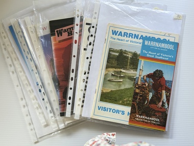 Warrnambool and District Historical Society Inc.
Booklet - Warrnambool Visitor's Handbooks 1979-2024, Collett, Bain and Gaspar, Printers, 1979-2014
... water of Lady Bay in the early morning. The bottom right hand corner has a Tourism Victoria logo. The rear cover has a mainly blue back ground with a pink orange and green colour splats contains words advertising the 2015 Fun 4 Kids Festival ...water of Lady Bay in the early morning. The bottom right hand corner has a Tourism Victoria logo. The rear cover has a mainly blue back ground with a pink orange and green colour splats contains words advertising the 2015 Fun 4 Kids Festival Booklet Warrnambool Visitor's Handbooks 1979-2024 Collett, Bain and Gaspar, Printers Philprint Warrnambool Nu Colorvue Productions Pty. ...This is a collection of eight Warrnambool Visitor handbooks produced between 1979 and 2014 by the City of Warrnambool Tourist Information Centre. They contain maps of Warrnambool, lists of services, accommodation and tourist attractions as well as many advertisements for local businesses.These handbooks give a useful snapshot of businesses and tourist attractions in Warrnambool for each of the years covered. (1979, 1980, 1986, 1990, 1993, 1994, 1995, 2014)[.1a] A 48 page booklet with white pages and blue printing. The front cover has a coloured photograph of Flagstaff Hill with boats on a man made lake in the foreground looking across Lake Pertobe toward South Warrnambool. [.1b] A coloured bifold brochure. The front cover has a fisherman on a cray-boat holding a crayfish in the lower section. The top quarter has a blue back ground with white printing. The rear cover is red and has small photos of the Hopkins River and the Framlingham Forest. [.2] A 48 page booklet with white pages and black printing. The front cover is white with black writing on the left hand side and a colour photograph of the Loch Ard peacock. The Warrnambool Premier Town stylised logo of seven Norfollk pines above blue waves is in the top right hand corner. There is a blank ink Warrnambool Library stamp underneath the logo. The rear cover has photographs of The Twelve Apostles and the Hopkins Falls and the Premier Town Logo [.3] A 40 page booklet with mainly black printing on white paper. There are three fold out maps of Warrnambool and the surrounding district. The glossy cover has a black background with a colour photograph of the Twelve Apostles taken at sunset. The rear cover has three small of Proudfoot's boathouse on the Hopkins River, Flagstaff Hill, and the main beach area. The front cover has black writing inside to peach coloured rectangles. The inside rear cover has a fold out coloured tour map of Western Victoria. [.4] A 40 page booklet printed on glossy white paper with coloured photographs and black and red printing. The front cover has a photograph of The Twelve Apostles surrounded by a white border. There is red writing in the upper border. There is a sandy coloured writing superimposed across the bottom of the photograph and a Victoria's Shipwreck Coast logo in the bottom right hand corner. [.5] A 44 page booklet printed on white paper with black printing. The cream coloured cover has a pale red rectangle with blue writing on the right hand facing edge and includes two stylised Norfolk pines and with waves underneath. There is is an intersecting blue rectangle with cream printing. [.6] A 48 page booklet printed on white paper with black printing. The cover is brown with a cream vertical strip containing black writing on the right hand side. There is a stylised map from Geelong to Mount Gambier showing the Great Ocean Road across the cover. [.7] A 48 page booklet printed on white paper with black print. The glossy colour cover has a photograph of a Southern Right whale fluke. There is white printing on a the blue background of the sky and sea. The bottom left hand side of the front cover has a Tourism Victoria logo made of jigsaw puzzle pieces. The back cover has a stylised coloured map of The Great Ocean Road located in a white rectangle at the top of the page. Within the rectangle is a small map of Australia locating Victoria and the part of Victoria covered by the map. [.8] A 64 page A5 coloured booklet printed on white pages with black print. The white front cover has black and grey print with a colour photograph of two people holding coffee cups watching four race horses being exercised on the beach and in the water of Lady Bay in the early morning. The bottom right hand corner has a Tourism Victoria logo. The rear cover has a mainly blue back ground with a pink orange and green colour splats contains words advertising the 2015 Fun 4 Kids Festival [.1a] Warrnambool The Heart of Victoria's Great Southwest Visitor's Handbook [.1b] Warrnambool City for all seasons; The Heart of Victoria's Great Southwest [.2] Warrnambool visitor's handbook Warrnambool Premier Town 1979-1982 [.3] Warrnambool Handbook Victoria [.4] Warrnambool The Shipwreck Coast [.5] Welcome to Warrnambool Warrnambool Visitors Handbook 1993-1994 [.6] Welcome to Warrnambool Visitors Handbook 1994-95 Rear cover: Warrnambool Centre of Victoria's Shipwreck Coast on Australia's Great Ocean Road [.7] Warrnambool Shipwreck Coast - Great Ocean Road; You'll love every piece of Victoria; Visitors Handbook [.8] Warrnambool Great Ocean Road Official Visitor Guide; It's a wonderful Warrnambool; You'll love every piece of Victoria visitvictoria.com. Rear Cover Live entertainment.Workshops.Creativity.Action 28 June - 5 July 2015 Australia's Best Children's Festival F4K The ultimate winter school holiday adventure Fun 4 kids festival Warrnambool For more information visit Fun4kids.com.au Warrnambool great Ocean Road Victoriawarrnambool, visitor handbooks, tourist information guides, warrnambool maps -
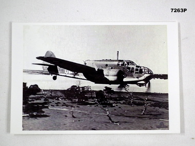 Bendigo Military Museum
Photograph - PHOTOGRAPH of an AIRPLANE, RAAF, c1942
... Under the plane is flat ground with a few gum trees. In the background is a water way of some sort....Under the plane is flat ground with a few gum trees. In the background is a water way of some sort. ...This photo relates to Ronald Leslie Schorey Dickinson RAAF, refer Cat No 7260 for service details. This is a black and white photo of a twin engine Beaufort Bomber in flight. It is flying low to the ground. Under the plane is flat ground with a few gum trees. In the background is a water way of some sort.Written on the back in blue ink is; "Beaufort Bomber being flown at Sale by Flying Officer Peter John Gibbs D.F.C in 1942. When I was at RAAF Laverton as a RAAF Cadet in 1942, F/O Peter Gibbs took me for my first ever flight in a similar plane".ww2, photo, aircraft, beaufort bomber -
 Kiewa Valley Historical Society
Photo - Rocky Valley Dam
... The middle shows the dam with water and its bank. There is snow on the ground....The middle shows the dam with water and its bank. There is snow on the ground. Photo - Rocky Valley Dam ...The State Electricity Commission of Victoria constructed the Kiewa Hydro Electric Scheme on the Bogong High Plains. The scheme consisted of storage dams and pondages, aqueducts, tunnels, pipelines, transmission lines and three power stations.. Rocky Valley dam was the biggest storage and the last to be completed.Rocky Valley dam was the largest storage within the Kiewa Hydro Electric Scheme. Begun in 1954 and completed in 1960. It was linked to McKay Creek Power StationColoured photo attached to cream cardboard. The background shows hills and the foreground a sign "Rocky Valley Dam ..." The middle shows the dam with water and its bank. There is snow on the ground.rocky valley dam, kiewa hydro electric scheme, secv -
 Kiewa Valley Historical Society
Container Tin Cylindrical
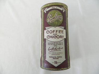
... This empty container of "Sunbeam" Coffee and Chicory finely ground "instant - just add boiling water" beverage was the start of the "fast" breakfast drink. ...This item was produced by a Melbourne Tea, Coffee and Cocoa Merchant importers(1898-1960). It was a time when local production of, coffee had yet not begun. Imports from India and the Asian region had dominance in the market place. The blending of coffee with chicory was a cheaper method of providing a flavour enriched drink which was marketed as "containing not less than 55 parts per cent by weight of coffee" The coffee weighed heavier than the chicory. This was a time before strict accurate consumer information/content became mandatory and legally enforceable.This empty container of "Sunbeam" Coffee and Chicory finely ground "instant - just add boiling water" beverage was the start of the "fast" breakfast drink. The use of grinding the coffee beans and percolation to obtain the final drink was at the start of the rural sector's decreasing the time for casual drinking. The once casual countryside psyche was now (mid to late 1900's) becoming more "on the go".This cylindrical container (coffee and chicory) is constructed from pressed cardboard with both ends enclosed by tin(pressed) lid and bottom. The outside wrapping is promotional and descriptive in the colours of purple background and information label areas with purple lettering on a white and silver background. The cylinder is made from 2 mm pressed cardboard.Main label " No.1" underneath "Sunbeam" underneath "COFFEE and CHICORY" UNDERNEATH "Containing Not Less than %% Parts Per Cent By Weight of Coffee" underneath in Hand Writing" Griffiths Bros Limited", below this "TEA ,COFFEE & COCOA MERCHANTS" Below this" Mellbourne, Sydney, Adelaide" and lastly "net 1lb weight". Alternate side "The Following Well Known Economical & Flavoury Teas" underneath this "Packed Specially For The Trade" underneath "SUNBEAM & VICTORY SIGNAL COCOA" and in smaller print "Absolutely Pure, Made in Australia" underneath Equal To The Best Imported"breakfast containers, food storage, instant coffee, speed breakfasts, domestic -
 Emerald Museum & Nobelius Heritage Park
Tool - Hole Punch - Nursery Tool, c. 1940s-60s
... In the 1940s, the Nobelius nursery began to lift trees from the ground and sell them in pots rather than as bare-rooted plants; at this time, plastic was not yet widely available and many discarded biscuit or fruit tins were reused as pots. Potted trees required regular watering...In the 1940s, the Nobelius nursery began to lift trees from the ground and sell them in pots rather than as bare-rooted plants; at this time, plastic was not yet widely available and many discarded biscuit or fruit tins were reused as pots. Potted trees required regular watering ...We have been unable to find a brand name or identify any identical items online or in other collections, indicating that this may be a custom-made tool designed specifically for use on a nursery - potentially C.A. Nobelius' nursery. It appears to be a foot-pedal operated hole punch, designed to reliably puncture metal pots for orchard trees. In the 1940s, the Nobelius nursery began to lift trees from the ground and sell them in pots rather than as bare-rooted plants; at this time, plastic was not yet widely available and many discarded biscuit or fruit tins were reused as pots. Potted trees required regular watering, and holes in the bottom of the pot for water to run out from; this hole punch may have facilitated an easier potting process until the popularisation of plastic pots in the 1960s.This item was a tool used in nursery practices in the 1940s, potentially including on the Nobelius nursery. Similar items are rare or difficult to find.This item rests on a cross base, with holes in each of the cross arms to allow it to be secured. The lower third of the central shaft is hollow, allowing for a foot pedal to descend through it. The middle third of the shaft is also hollow, with a loose central section affixed to the foot pedal moving up and down within it. In the upper third of the shaft, the hollow outer layer ends, and the mobile inner shaft is wrapped in a spring and affixed to the crossbar at the top of the item. Four small fixed crossbars also emerge from the sides of the middle third, attached to vertical rods through a rotating joint; the vertical rods attach with another rotating joint to pieces emerging through through the upper crossbar surface and ending with sharp points. The base and central shaft was painted yellow, and the upper crossbar head is painted red, though both are heavily faded. Together, these parts form a contraption that, when the foot pedal is pressed down, pulls the head downwards, in the process rotating the pointed pieces inwards to puncture the item placed on the head. When pressure is released, the spring returns the head to its initial position.N/Anursery, tools -
 Bendigo Military Museum
Memorabilia - TAPESTRY, FRAMED, Post WW1
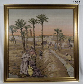
... Egyptian scene tapestry with 3 civilians collecting & using water in foreground, palm trees mid ground, buildings & a number of civilians in background. ...Egyptian scene tapestry with 3 civilians collecting & using water in foreground, palm trees mid ground, buildings & a number of civilians in background. ...Timber frame, gold with black highlights, glass front. Egyptian scene tapestry with 3 civilians collecting & using water in foreground, palm trees mid ground, buildings & a number of civilians in background. Colours - browns, yellows, black, pale blue, white & greens. handcrafts-tapestry, frame accessories, eygpt -
 Eltham District Historical Society Inc
Film - Video (VHS), Nillumbik Shire Council, The Nillumbik Story, 1996
... ground tower...Kinglake...Maroondah Aqueduct...Matcham Skipper...Memorial Park...Ming Mackay (1918-2009)...Montsalvat...Mudbrick houses...Music...musicians...nesting area...Nillumbik Historical Society...Nillumbik Shire...North Warrandyte...Old timer...Orchards...Peter Brock...Plenty River...poets...Population...Recreation...recreational activities...revegetation...Robert Hoddle...Sandy Brock...Shillinglaw Cottage...Shire of Eltham War Memorial...Sigmund Jorgensen...St Andrews Hotel...St Andrews Market...Sugarloaf Reservoir...Templestowe...The Hill...tourism...Viewing platform...Warrandyte...water...Ground. Significant tourism opportunities for the shire with 3 million potential day-trippers in metropolitan Melbourne. Council and community working together to find a way to promote the shires natural and artistic assets. At Arthurs Creek, the Brock family and neighbours working together to take care of their waterway. Peter Brock’s uncle, Sandy Brock talks about environmental management and the Arthurs Creek Landcare group and actions to eradicate blackberry problem. Having previously planted Cypress rows they are replacing them with indigenous species to improve the water...Ground. Significant tourism opportunities for the shire with 3 million potential day-trippers in metropolitan Melbourne. Council and community working together to find a way to promote the shires natural and artistic assets. At Arthurs Creek, the Brock family and neighbours working together to take care of their waterway. Peter Brock’s uncle, Sandy Brock talks about environmental management and the Arthurs Creek Landcare group and actions to eradicate blackberry problem. Having previously planted Cypress rows they are replacing them with indigenous species to improve the water ...PART 1 – NILLUMBIK (00:00-07:17) Opening features various scenes around Nillumbik Shire. For 40,000 years Nillumbik was the home of the Wurundjeri people. Robert Hoddle gave the district its name. Jock Ryan, then president of Nillumbik Historical Society discusses the names Nillumbik and Diamond Creek. In the late 1830s white occupation began with gold found in Warrandyte in 1851 and 12 years later at Diamond Creek -the Diamond Reef which led to the Caledonian gold rush. Jock Ryan discusses the Diamond Creek mine, which was thriving until it burnt out in 1915. Large numbers of workmen moved into area in late 1870s to construct the Maroondah Aqueduct. With growing population of Melbourne, the nearby Yan Yean system had severely disrupted the flow of the Plenty River, forcing the closure of three flour mills there. The aqueduct came to the rescue carrying water 66km from Healesville to Preston. When the Diamond Creek gold mine burnt down the local economy suffered but fruit growing industry had already been established and Diamond Creek became a thriving fruit growing centre. Interview with Jack Powell, a long-time fruiterer at St Andrews market, his family had lived in the area for a hundred years, 3 to 4 generations, “a lot of hard work”. By the time the railway arrived fruit growing was no longer competitive. The railway brought the city closer and day trippers. The Green Wedge separates the shire from the more densely developed neighbours such as Whittlesea, Doncaster, Templestowe, Bulleen and Greensborough. Population at the time (1996) was 19,000 but links to the past remain strong. Mudbrick houses along the Heritage Trail The saving of Shillinglaw Cottage from demolition in 1963 and relocation brick by brick. PART 2 – ENVIRONMENT (07:18-14:44) Peter Brock (with Bev Brock in background) at St Andrews market discusses his childhood growing up in the district and the environment and the values it instilled upon him and his own family. The Brocks have been in the district since the 1860s. Nillumbik Shire responsible for managing three catchment areas; Diamond Creek, Arthurs Creek and Watsons Creek. Follows the course of the Diamond Creek commencing in Kinglake through the district to its confluence with the Yarra River at Eltham at Eltham Lower Park. Highlights Eltham Lower Park community revegetation program and the newly constructed (1996) viewing platform built of new and recycled timbers at the confluence of the Diamond Creek and Yarra River. Also featured are outdoor recreation on the river and at Eltham Lower Park including the Diamond Valley miniature railway. Sugarloaf reservoir and recreational activities and fishing. Aerial view of Memorial Park and Shire of Eltham War Memorial tower at Garden Hill, Kangaroo Ground. Significant tourism opportunities for the shire with 3 million potential day-trippers in metropolitan Melbourne. Council and community working together to find a way to promote the shires natural and artistic assets. At Arthurs Creek, the Brock family and neighbours working together to take care of their waterway. Peter Brock’s uncle, Sandy Brock talks about environmental management and the Arthurs Creek Landcare group and actions to eradicate blackberry problem. Having previously planted Cypress rows they are replacing them with indigenous species to improve the water supply, keeping cattle out of the creek bed to improve the quality downstream flowing into the Yarra. Eltham East Primary School Band playing “All things bright and beautiful” merges into scenes of the bushland sanctuary set aside by the school in 1980 with unidentified teacher discusses the sanctuary and their education program and school children’s comments. Plight of a family of Wedgetail eagles nesting in the path of a developer’s bulldozer at North Warrandyte and actions to save their nesting areas. PART 3 – ARTS (14:45-22:00) Arts and Jazz festival at Montsalvat featuring interviews with Sigmund Jorgensen discussing Montsalvat and its principles. Also Matcham Skipper. Clifton Pugh’s funeral at Montsalvat and his legacy at Dunmoochin near Cottlesbridge with artists in residence, at the time, Chicago artist Charles Reddington who discusses the benefits of the experience. An unidentified female artist also talks about the program and why people are drawn to the area. Unidentified man on street talking about the amount of talent in the area, artists, poets, musicians, authors. Artist Ming Mackay (1918-2009) interviewed talking about the people she mixes with on “the Hill”. Works of local artists are displayed Eltham Library Community Gallery and Wiregrass gallery with a new coffee shop at the Wiregrass making it an even more popular destination. Music at St Andrews Hotel (may be a little bit country) and the Saturday market where likely to hear anything. Sellers and patrons at the market asked about what attracts them to the market and where they came from. Scenes of poets/authors giving readings. CREDITS Music by John Greenfield from the CD Sweet Rain “The Snow Tree”, Uncle Music UNC 2001 Cameras - David Mirabella and Peter Farragher Editor – Olwyn Jones Written and Produced by Jason Cameron A Jason Cameron Proction for Nillumbik ShireProvides a record of the relatively newly created Shire of Nillumbik at the time and the features and attactions of the shire in its people arts, culture and environmentVHS Cassette (five copies) DVD (one copy) Converted to MP4 file format 0:22:00, 1.60GBvideo recording, arthurs creek, arthurs creek landcare group, artists, artists in residence, arts, arts festival, authors, blackberry, brock family, bulldozer, bulleen, bushland sanctuary, caledonian gold rush, charles reddington, clifton pugh, cottlesbridge, cypress rows, developer, diamond creek, diamond creek mine, diamond reef, diamond valley miniature railway, doncaster, dunmoochin, education program, eeps, eltham, eltham east primary school, eltham east primary school band, eltham library community gallery, eltham lower park, environment, fishing, flour mill, fruit growing, fruiterer, garden hill, gold mining, green wedge, greensborough, heritage trail, hurstbridge railway line, jazz festival, jock ryan, kangaroo ground, kangaroo ground tower, kinglake, maroondah aqueduct, matcham skipper, memorial park, ming mackay (1918-2009), montsalvat, mudbrick houses, music, musicians, nesting area, nillumbik historical society, nillumbik shire, north warrandyte, old timer, orchards, peter brock, plenty river, poets, population, recreation, recreational activities, revegetation, robert hoddle, sandy brock, shillinglaw cottage, shire of eltham war memorial, sigmund jorgensen, st andrews hotel, st andrews market, sugarloaf reservoir, templestowe, the hill, tourism, viewing platform, warrandyte, water catchment area, watsons creek, wedgetail eagle, whittlesea, wiregrass gallery, wurundjeri, yarra river, jack powell -
Eltham District Historical Society Inc
Document - Folder, Pelling, Charis
... Ground Victoria...Michael Pelling...Margaret Pelling...Nicholas Pelling...Deborah Pelling...Warrandyte Water...Charis Pelling Whittlesea Show Kangaroo Ground Victoria Michael Pelling Margaret Pelling Nicholas Pelling Deborah Pelling Warrandyte Water Works Trust Eltham Arts Council Eltham Old People's Committee Eltham Art Show Shillinglaw Cottage Preservation Committee Woodlands Kangaroo Ground Victoria Gareth Jones roberts Peter Glass Alkis Astrix Matcham Skipper Mervyn Horton The Flavor of Eltham Bush fire January 1969 The Hall Kangaroo Ground Victoria Professor William Osborne Dr Ethel Osborne William Pelling Alistair Knox Harold Bartlett Gerald Yunken Edwin Oswald Pelling Charis Meta Alexander Pelling Newspaper clippings, A4 photocopies, etc Pelling, Charis Document Folder ...Charis Pelling, daughter of Professor William Osborne and Dr Ethel Osborne, was active in local activities, including being Eltham Shire's first female president and a councillor. Contents Newspaper articles: About Whittlesea Show 1964, Diamond Valley News, 1964 (photocopy). Magazine article: "A woman who gets things done", The Australian Women's Weekly, 26 October 1966. Charis Pelling's life and activities. Note card: Thanks for sympathy following destruction of "Woodlands" and "The Hall" in 8 January 1969 bushfire. Newspaper article: "Quietly proud of her life", Diamond Valley News, 19 June 1984. Charis Pelling's childhood and activities. Note card: Thanks for sympathy following death of Edwin Oswald Pelling. Newspaper notice: Death notice, Charis Meta Aleander Pelling. Order of Service: Celebration of life of Charis Meta Aleander Pelling, 2006. Letter: Eltham District Historical Society to Charis Pelling, 21 June 1995, Invitation to be presented with certificate to her as foundation President of the Society. Note card: Charis Pelling, Thanks for presentation. Newsletter: Eltham District Historical Society, number 172, January 2007. Obituary of Charis Meta Alexander Pelling.Newspaper clippings, A4 photocopies, etccharis pelling, whittlesea show, kangaroo ground victoria, michael pelling, margaret pelling, nicholas pelling, deborah pelling, warrandyte water works trust, eltham arts council, eltham old people's committee, eltham art show, shillinglaw cottage preservation committee, woodlands kangaroo ground victoria, gareth jones roberts, peter glass, alkis astrix, matcham skipper, mervyn horton, the flavor of eltham, bush fire january 1969, the hall kangaroo ground victoria, professor william osborne, dr ethel osborne, william pelling, alistair knox, harold bartlett, gerald yunken, edwin oswald pelling, charis meta alexander pelling -
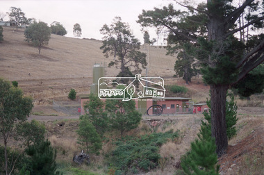
 Eltham District Historical Society Inc
Photograph - Digital Photograph, Alan King, Wycliffe Centre, Graham Road, Kangaroo Ground, 2008
... Ground property, Mrs Elsie Graham, would have been delighted, as she had wanted her land to be used for ‘God’s service’. Mud-brick architect and Christian, Alistair Knox, offered to design the centre at no charge. Despite a drought, straw was donated to make bricks. Many volunteers helped with the building, including church youth groups who made mud-bricks. Volunteers planted thousands of native plants, watered...Ground property, Mrs Elsie Graham, would have been delighted, as she had wanted her land to be used for ‘God’s service’. Mud-brick architect and Christian, Alistair Knox, offered to design the centre at no charge. Despite a drought, straw was donated to make bricks. Many volunteers helped with the building, including church youth groups who made mud-bricks. Volunteers planted thousands of native plants, watered ...Wycliffe translates the Bible for people around the world. Published: Nillumbik Now and Then / Marguerite Marshall 2008; photographs Alan King with Marguerite Marshall.; p171 The peace and beauty of Australia’s Wycliffe Centre reflects what it aims to bring to thousands of people around the world. Kangaroos calmly feed, accompanied by bird song, near the mud-brick buildings set amongst Kangaroo Ground’s rolling hills. On 11 hectares off Graham Road, the centre aims to transform people’s lives by giving groups around the world, with no written language, help with literacy and Bible translation into their own tongue. Associate Director, Harley Beck, says reading the Bible (probably history’s most influential collection of books), in one’s own language, provides a strong moral basis, helping people withstand exploitation and escape poverty. One of Wycliffe’s field partners, SIL (formerly Summer Institute of Linguistics) Papua New Guinea, has won two UNESCO awards, and SIL branches in many other countries have won international and national awards. The translators are modern heroes. They undertake hardships, forsaking for years, sometimes decades, a salary and the soft western lifestyle, to face loneliness and primitive conditions that most of us would not even contemplate. No staff is paid a salary. An example is the first Australian Director and former International President, David Cummings, who for 50 years has depended on donations from supporters and churches. Students of all ages at the EQUIP Training School on the site come from all walks of life. They train in linguistics and learn how to communicate in a way that is sensitive to other cultures. Spiritual resilience is encouraged, enabling people to persist until the job in the field is done, which takes on average ten to 15 years. Courses range from a few weeks to a year. The Wycliffe concept was born in the 1920s when American missionary, Cameron Townsend, found a Spanish Bible was inadequate to evangelise the Cakchiquel people of Guatemala. When a Cakchiquel man challenged: ‘If your God is so great, why doesn’t he speak my language?’ Townsend decided to translate the Bible into all languages! He founded a linguistics training school in 1934, naming it after 14th century theologian John Wycliffe, the first to translate the Bible into English. The first Wycliffe Bible was completed in 1951 in the Mexican San Miguel Mixtec language. In May 2007 after 30 years of work, Wycliffe Australia, with other organisations, completed the first Bible for indigenous people in the Kriol* language, for about 30,000 people in northern Australia. Wycliffe Australia began in 1954 in the Keswick Bookshop basement, Collins Street, Melbourne. As the organisation grew, its quarters became so cramped that Director Cummings at times interviewed potential recruits in his car! The development of the Kangaroo Ground property is a story of faith and generosity. In 1967 Cummings proposed moving to a larger property despite having no funds. Within a month Wycliffe received a $20,000 donation and a gift of land towards a national centre. An earlier owner of the Kangaroo Ground property, Mrs Elsie Graham, would have been delighted, as she had wanted her land to be used for ‘God’s service’. Mud-brick architect and Christian, Alistair Knox, offered to design the centre at no charge. Despite a drought, straw was donated to make bricks. Many volunteers helped with the building, including church youth groups who made mud-bricks. Volunteers planted thousands of native plants, watered by recycled water from the site’s dam. Building began in 1968 and in 1983 the South Pacific SIL School (now EQUIP Training) followed. Wycliffe, the world’s largest linguistic organisation, and other organisations, have translated the Scriptures into more than 2000 languages. But another 2000 languages still lack any portion of the Bible. However translations are now completed more quickly, because of new computer programs and as education spreads, more speakers of the local language can assist. Despite the growth of secularisation, Beck says support for Wycliffe Australia, which has offices in all states and the ACT, is stronger than ever. * Kriol is a Pidgin language, which has become a speech community’s prime language.This collection of almost 130 photos about places and people within the Shire of Nillumbik, an urban and rural municipality in Melbourne's north, contributes to an understanding of the history of the Shire. Published in 2008 immediately prior to the Black Saturday bushfires of February 7, 2009, it documents sites that were impacted, and in some cases destroyed by the fires. It includes photographs taken especially for the publication, creating a unique time capsule representing the Shire in the early 21st century. It remains the most recent comprehenesive publication devoted to the Shire's history connecting local residents to the past. nillumbik now and then (marshall-king) collection, graham road, kangaroo ground, wycliffe centre