Showing 2 items matching "gunter’s chain"
-
Federation University Historical Collection
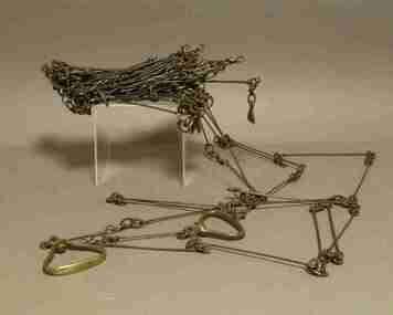
Instrument - Survey Chain, Chesterman, Gunter's Survey Chain
... , with markers at 10 link intervals. gunter's chain survey chain surveyor ...Before metric measurement was introduced land was measured in chains and links. The chain was a precision part of a surveyor's equipment. It required frequent calibration, yet needed to be sturdy enough to be dragged through rough terrain for years. A standard survey chain is 66 feet (or 20.117m) long and made up of 100 links. Each link is 7.92 inches (approximately 201mm) long, measured from the inside of the loop. The handles are for tensioning the chain in use, they are not part of the length of the chain. In pre-metric units, there were 80 chains to 1 mile (equals 1.609km) This surveyor’s chain has an 8-inch link pitch, with markers at 10 link intervals. This metal surveyor’s chain (or Gunter's Chain) has an 8-inch link pitch, with markers at 10 link intervals, and handles at either end. A Surveyor’s Chain was 66 feet long, and made up of 100 links connected by two rings. A link in measurement includes the two rings at each end. gunter's chain, survey chain, surveyor s chain, perch, rood, surveying -
Department of Energy, Environment and Climate Action
Criterion Survey Laser
There had been timber assessments in Victorian State forests since the late 1920’s, coinciding with arrival of the three Norwegian foresters. The program was accelerated during the post-war housing boom. It was driven by the push eastwards away from the Central Highlands to find timber resources after the 1939 bushfire salvage was completed. Spending time in the field with assessment branch was a “rite of passage” for many young forestry graduates leaving Creswick. The work was arduous, and measurements were taken with simple and robust equipment like gunters chains, prismatic compass, Abney levels, barometers and clinometers. Data was recorded by hand onto waterproof paper. The Statewide Forest Resource Inventory (SFRI) project began in 1993 and followed a few years after the release Timber industry Strategy. The aim was to bolster the existing 1:25000 scale mapping and improve the accuracy of the volume and growth estimates for the forest estate. This scary looking gadget looks like a speeding radar used by the cops. The LTI Criterion Survey Laser and Rangefinder was a powerful instrument that could measure and record tree height, diameter at any visible point up the tree. It was used to identify and map tree faults such as branches, scars and knots and to calculate tree taper functions. When used correctly, it has an accuracy of better than 1% for height and diameter. It could also measure survey information such as asmuth, distance and elevation. It was expensive back in the day (more than $20,000) and heavy. This one turned up when the retired foresters were cleaning out Beechworth museum in July 2025. It’s now at Altona and recorded in Victorian Collections Criterion Survey Laser with box and batterysurveying, forest measurement