Showing 28 items matching "highbury road burwood east"
-
 Whitehorse Historical Society Inc.
Map, Springvale Road, 1990
... Road...Vermont South...Burwood Highway...Burwood East...Springvale Road...Burwood East...Highbury...Aerial photograph of cnr Springvale Road and Burwood Highway, south past Highbury Road, west to Middleborough Road and east to Morack Road Vermont South....Whitehorse Historical Society Inc. 2-10 Deep Creek Road Mitcham melbourne Aerial photographs Morack Road Vermont South Burwood Highway Burwood East Springvale Road Burwood East Highbury Road Burwood East Burwood East Vermont South Aerial photograph of cnr Springvale Road and Burwood Highway, south past Highbury Road, west to Middleborough Road and east to Morack Road Vermont South. ...Aerial photograph of cnr Springvale Road and Burwood Highway, south past Highbury Road, west to Middleborough Road and east to Morack Road Vermont South.Aerial photograph of cnr Springvale Road and Burwood Highway, south past Highbury Road, west to Middleborough Road and east to Morack Road Vermont South.Aerial photograph of cnr Springvale Road and Burwood Highway, south past Highbury Road, west to Middleborough Road and east to Morack Road Vermont South.aerial photographs, morack road, vermont south, burwood highway, burwood east, springvale road, burwood east, highbury road, burwood east, burwood east, vermont south -
 Whitehorse Historical Society Inc.
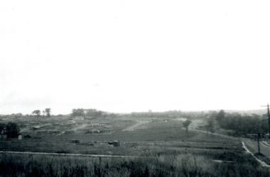
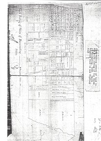
Photograph, Subdivision of Area of Burwood, 1971
... highbury road...burwood east...Whitehorse Historical Society Inc. 2-10 Deep Creek Road Mitcham melbourne highbury road burwood east springvale road burwood highway burwood east Subdivision Black and white photo of Subdivision of Area of Burwood, Springvale and Highbury Roads. ...Black and white photo of Subdivision of Area of Burwood, Springvale and Highbury Roads.highbury road, burwood east, springvale road, burwood highway burwood east, subdivision -
Whitehorse Historical Society Inc.
Legal record - Land Title, Certificate of Title, 23/12/1927 12:00:00 AM
... Middleborough Road Burwood East...Highbury...Whitehorse Historical Society Inc. 2-10 Deep Creek Road Mitcham melbourne Anderson Thomas Gifford Middleborough Road Burwood East Highbury Road Burwood East 3 Acres 2 roods 8 and 7/10th perches, pt. ...3 Acres 2 roods 8 and 7/10th perches, pt. Crown section 108 Parish of Nunawading, owned by Thomas Gifford Anderson. Vol. 5411 fol. 10820053 Acres 2 roods 8 and 7/10th perches, pt. Crown section 108 Parish of Nunawading, owned by Thomas Gifford Anderson. Vol. 5411 fol. 10820053 Acres 2 roods 8 and 7/10th perches, pt. Crown section 108 Parish of Nunawading, owned by Thomas Gifford Anderson. Vol. 5411 fol. 1082005anderson, thomas gifford, middleborough road burwood east, highbury road burwood east -
 Whitehorse Historical Society Inc.
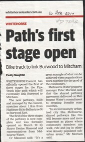
Article, Path's first stage open, 2017
... ...highbury road...burwood east...Whitehorse Historical Society Inc. 2-10 Deep Creek Road Mitcham melbourne bicycle paths highbury road burwood east ballantyne street melbourne water city of whitehorse Whitehorse Council has opened the first of three stages of the Pipe Track bike path which will eventually link Burwood to Mitcham. ...Whitehorse Council has opened the first of three stages of the Pipe Track bike path which will eventually link Burwood to Mitcham.bicycle paths, highbury road, burwood east, ballantyne street, melbourne water, city of whitehorse -
Whitehorse Historical Society Inc.
Map, Springvale Road, 1981
... Burwood East...Springvale Road...Burwood East...Burwood Highway...Burwood East...Sevenoaks Road...Burwood East...Highbury...Whitehorse Historical Society Inc. 2-10 Deep Creek Road Mitcham melbourne Aerial photographs Burwood East Springvale Road Burwood East Burwood Highway Burwood East Sevenoaks Road Burwood East Highbury Road Burwood East Aerial photograph of area including cnr. ...Aerial photograph of area including cnr. Springvale Road and Burwood Highway, south past Highbury Road and west to Sevenoaks Road.Aerial photograph of area including cnr. Springvale Road and Burwood Highway, south past Highbury Road and west to Sevenoaks Road.Aerial photograph of area including cnr. Springvale Road and Burwood Highway, south past Highbury Road and west to Sevenoaks Road.aerial photographs, burwood east, springvale road, burwood east, burwood highway, burwood east, sevenoaks road, burwood east, highbury road, burwood east -
Whitehorse Historical Society Inc.
Map, Springvale Road, 1975
... ...Highbury Road...Burwood East...Aerial photograph of area around cnr. of Springvale Road and Burwood Highway, south past Highbury Road and East in Vermont South....Whitehorse Historical Society Inc. 2-10 Deep Creek Road Mitcham melbourne Aerial photographs Vermont South Highbury Road Burwood East Burwood Highway Burwood East Burwood East Aerial photograph of area around cnr. of Springvale Road and Burwood Highway, south past Highbury Road and East in Vermont South. ...Aerial photograph of area around cnr. of Springvale Road and Burwood Highway, south past Highbury Road and East in Vermont South.Aerial photograph of area around cnr. of Springvale Road and Burwood Highway, south past Highbury Road and East in Vermont South.Aerial photograph of area around cnr. of Springvale Road and Burwood Highway, south past Highbury Road and East in Vermont South.aerial photographs, vermont south, highbury road, burwood east, burwood highway, burwood east, burwood east -
Whitehorse Historical Society Inc.
Legal record - Land Title, Springvale Road, 1960
... Road...Burwood East...Burwood Highway...Burwood East...Highbury...Springvale Road and Burwood Highway, south past Highbury Road and east to Vermont South....Whitehorse Historical Society Inc. 2-10 Deep Creek Road Mitcham melbourne Aerial photographs Springvale Road Burwood East Burwood Highway Burwood East Highbury Road Burwood East Vermont South Aerial photograph of cnr. ...Aerial photograph of cnr. Springvale Road and Burwood Highway, south past Highbury Road and east to Vermont South.Aerial photograph of cnr. Springvale Road and Burwood Highway, south past Highbury Road and east to Vermont South.Aerial photograph of cnr. Springvale Road and Burwood Highway, south past Highbury Road and east to Vermont South.aerial photographs, springvale road, burwood east, burwood highway, burwood east, highbury road, burwood east, vermont south -
Whitehorse Historical Society Inc.
Map, Springvale Road, 1987
... Road...Burwood East...Highbury...Whitehorse Historical Society Inc. 2-10 Deep Creek Road Mitcham melbourne Aerial photographs Blackburn Road Burwood East Highbury Road Burwood East Burwood Highway Burwood East Springvale Road Burwood East Burwood East Aerial photograph of cnr Springvale Road and Burwood Highway, south past Highbury Road and west past Blackburn Road. ...Aerial photograph of cnr Springvale Road and Burwood Highway, south past Highbury Road and west past Blackburn Road.Aerial photograph of cnr Springvale Road and Burwood Highway, south past Highbury Road and west past Blackburn Road.Aerial photograph of cnr Springvale Road and Burwood Highway, south past Highbury Road and west past Blackburn Road.aerial photographs, blackburn road, burwood east, highbury road, burwood east, burwood highway, burwood east, springvale road, burwood east, burwood east -
Whitehorse Historical Society Inc.
Map, Springvale Road, 1968
... ...Highbury Road...Burwood East...Whitehorse Historical Society Inc. 2-10 Deep Creek Road Mitcham melbourne Aerial photographs Highbury Road Burwood East Burwood Highway Burwood East Springvale Road Burwood East Aerial photograph of cnr Springvale Road and Burwood Highway, south past Highbury Road. ...Aerial photograph of cnr Springvale Road and Burwood Highway, south past Highbury Road.Aerial photograph of cnr Springvale Road and Burwood Highway, south past Highbury Road.Aerial photograph of cnr Springvale Road and Burwood Highway, south past Highbury Road.aerial photographs, highbury road, burwood east, burwood highway, burwood east, springvale road, burwood east -
Whitehorse Historical Society Inc.
Map, Highbury Road, c1970
... Highbury Road...Burwood East...Whitehorse Historical Society Inc. 2-10 Deep Creek Road Mitcham melbourne Highbury Road Burwood East Gareth Drive Burwood East Blackburn Road Burwood East Bennett Avenue Burwood East Rae Street Burwood East Joy Street Burwood East Folkestone Road Burwood East Burwood East Primary School No. 454 Aerial Photographs Enlarged aerial photo of Highbury Park area. ...Enlarged aerial photo of Highbury Park area.Enlarged aerial photo of Highbury Park area.Enlarged aerial photo of Highbury Park area.highbury road, burwood east, gareth drive, burwood east, blackburn road, burwood east, bennett avenue, burwood east, rae street, burwood east, joy street, burwood east, folkestone road, burwood east, burwood east primary school no. 454, aerial photographs -
Whitehorse Historical Society Inc.
Document, History of Tally Ho Boys Home, 1972
... Boundary Road Burwood East...Highbury... Highbury Road Burwood East Springvale Road Burwood East Leach Nancy Hinneberg Ernest. ...Three papers on History of Boys Training Farm, Highbury Road, Tally Ho3 papers on History of Boys Training Farm, Highbury Road, Tally Ho, commenced in 1903 by Rev. and Mrs George Cole. The story covers the period from 1903-1930. The farm was built on land bought from Abel Hoadley for 1,000 Pounds near the corner of Springvale Road in Boundary Road (now Highbury Road). 2 letters (16/7/1972 & 28/5/1972) to Nancy Leach from E. Hinneberg, Assistant Superintendent, Tally Ho, about his association with Tally Ho.Three papers on History of Boys Training Farm, Highbury Road, Tally Hoyouth services, tally ho boys home, cole, george, rev., cole, mrs, hoadley, abel, boundary road burwood east, highbury road, burwood east, springvale road, burwood east, leach, nancy, hinneberg, ernest. -
Whitehorse Historical Society Inc.
Article, Tally Ho
... Burwood East...Highbury Road...Whitehorse Historical Society Inc. 2-10 Deep Creek Road Mitcham melbourne Youth Services Tally Ho Boys Home Burwood East Highbury Road Burwood East Springvale Road Burwood East Burwood Road Burwood Tally Ho Youth Services Lingard Ian Three articles about the history and imminent move of Tally Ho Youth Centre. ...Three articles about the history and imminent move of Tally Ho Youth Centre.Three articles about the history and imminent move of Tally Ho Youth Centre.Three articles about the history and imminent move of Tally Ho Youth Centre.youth services, tally ho boys home, burwood east, highbury road, burwood east, springvale road burwood east, burwood road burwood, tally ho youth services, lingard, ian -
 Whitehorse Historical Society Inc.
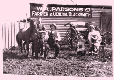
Photograph - B/W photograph - Copy, William Parsons Farrier
... Situated corner Howletts Road (Blackburn Road) and Tally Ho Road (Highbury Road ) East Burwood. The man seated is the neighbor Mr Clarke who owned the nearby hotel....Whitehorse Historical Society Inc. 2-10 Deep Creek Road Mitcham melbourne W A Parsons Blacksmith East Burwood B&W copy showing W Parsons standing, wife Clara and children Joyce and Ray. Situated corner Howletts Road (Blackburn Road) and Tally Ho Road (Highbury Road ) East Burwood. ...B&W copy showing W Parsons standing, wife Clara and children Joyce and Ray. Situated corner Howletts Road (Blackburn Road) and Tally Ho Road (Highbury Road ) East Burwood. The man seated is the neighbor Mr Clarke who owned the nearby hotel.w a parsons, blacksmith, east burwood -
 Whitehorse Historical Society Inc.
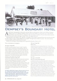
Article, Dempsey's Boundary Hotel, 1873
... An article about Dempsey's Boundary Hotel, NW. cnr Highbury & Middleborough Roads, East Burwood. Licensees Mary Anne & William Dempsey....Road Mitcham melbourne Licensees Mary Anne & William Dempsey. Dempsey William Boundary Hotel Green Mount Dempsey Mary Anne Parish of Nunawading An article about Dempsey's Boundary Hotel, NW. cnr Highbury & Middleborough Roads, East Burwood. ...An article about Dempsey's Boundary Hotel, NW. cnr Highbury & Middleborough Roads, East Burwood.An article about Dempsey's Boundary Hotel, NW. cnr Highbury & Middleborough Roads, East Burwood. Licensees Mary Anne & William Dempsey.An article about Dempsey's Boundary Hotel, NW. cnr Highbury & Middleborough Roads, East Burwood. dempsey william, boundary hotel, green mount, dempsey mary anne, parish of nunawading -
 Whitehorse Historical Society Inc.
Photograph, Whitehorse Historical Society, 2011
... 3 coloured photographs taken at a display of the 150th anniversary of the Burwood East Primary School, corner Blackburn and Highbury Roads, East Burwood....Whitehorse Historical Society Inc. 2-10 Deep Creek Road Mitcham melbourne whitehorse historical society displays 3 coloured photographs taken at a display of the 150th anniversary of the Burwood East Primary School, corner Blackburn and Highbury Roads, East Burwood. ...3 coloured photographs taken at a display of the 150th anniversary of the Burwood East Primary School, corner Blackburn and Highbury Roads, East Burwood.whitehorse historical society, displays -
 Whitehorse Historical Society Inc.
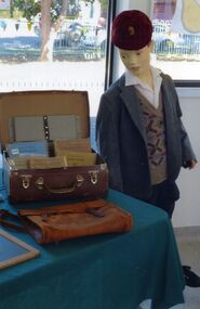
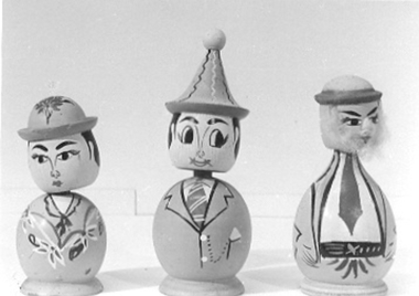
Leisure object - Nodding Dolls x 3
... Found around 1977 at the Highbury Road, Ballyshanassy Reserve in Burwood East....Whitehorse Historical Society Inc. 2-10 Deep Creek Road Mitcham melbourne Found around 1977 at the Highbury Road, Ballyshanassy Reserve in Burwood East. toys general Three round based wooden dolls with spring based heads which allow them to nod. ...Found around 1977 at the Highbury Road, Ballyshanassy Reserve in Burwood East.Three round based wooden dolls with spring based heads which allow them to nod. Painted faces & details on bodies.toys, general -
 Whitehorse Historical Society Inc.
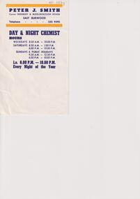
Flyer, Peter J. Smith
... Smith, corner Highbury and Middleborough Roads, East Burwood, Day & Night Chemist hours...Whitehorse Historical Society Inc. 2-10 Deep Creek Road Mitcham melbourne Peter J. Smith, corner Highbury and Middleborough Roads, East Burwood, Day & Night Chemist hours Smith Peter J Pharmacies Peter J. ...Peter J. Smith, Day & Night Chemist hoursA small flyer with blue and yellow coloured printnon-fictionPeter J. Smith, Day & Night Chemist hourssmith peter j, pharmacies -
Whitehorse Historical Society Inc.
Document, The 'Mullens House', n.d
... Mr Mullen's parents lived in Highbury Road, near East Burwood Primary School and were pioneers of East Burwood....Mr Mullen's parents lived in Highbury Road, near East Burwood Primary School and were pioneers of East Burwood. ...Story of the 'Mullens House', originally small dwelling made of hand made bricks by Mrs Mullens' father, Mr Forbes of Glen Waverley. Came from Scotland 93 years ago. As the family increased more rooms were added. Hugh Mullens was a woodcutter and later an orchardist and later still a road contractor. Mrs Tainton, a daughter, still lives in part of the original property. Another daughter, Mrs Stocks who was a widow stayed on with her mother at the old home. It is now the property of Melbourne & Metropolitan Board of Works. Mr & Mrs Hugh Mullen's had 12 children. Mr Mullen's parents lived in Highbury Road, near East Burwood Primary School and were pioneers of East Burwood.hugh, forbes, tainton, r (mrs), stocks, (mrs), melbourne and metropolitan board of works, highbury road, mullen's -
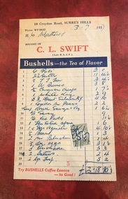
 Surrey Hills Historical Society Collection
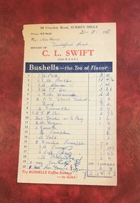
Document - Account, C. L. Swift order docket re Mrs Matthews. 21/8/1957
... Together they ran the grocery store at 10 Croydon Road from 1949 until some time after 1954. In the 1980s they were living in Highbury Road, East Burwood and Clive was working for Unigate (later Bonlac) in a managerial position. ...Together they ran the grocery store at 10 Croydon Road from 1949 until some time after 1954. In the 1980s they were living in Highbury Road, East Burwood and Clive was working for Unigate (later Bonlac) in a managerial position. ...Clive Leslie Swift (RAAF 430415) was born in Elsternwick in 1924 and served in the RAAF in Borneo during WW2. He was mentioned in dispatches. He married Enid (Ina) Mary Smith in 1947. Together they ran the grocery store at 10 Croydon Road from 1949 until some time after 1954. In the 1980s they were living in Highbury Road, East Burwood and Clive was working for Unigate (later Bonlac) in a managerial position. (REF: Oral testimony, Libby Wilson, Canterbury History Group). The shop continued after the Swifts left but was later destroyed by fire. Clive Swift died in March 2014. This and other dockets were tucked into Ruth Matthews' recipe folder. Ruth and Harold Geoffrey (Geoff) Matthews lived at 42 Guildford Road, Surrey Hills. The donor recalled that her paternal grandmother (Ethel May Matthews) also occasionally shopped at the Swifts' shop as it was closer to her home (31 Guildford Road) than either than Griffith’s on Union Road or Thomas’ on Maling Road . Dockets such as these are reflective of shopping in the pre-supermarket era when women generally walked to the local shop or had proprietors or a staff member come to the house to take weekly orders. A pre-printed grocery docket for C. L. Swift (Late R.A.A.F.) on cream (discoloured) paper printed in black, red and blue filled in with 20 hand-written items, their prices and the total of the grocery order. Signed with initials as having been paid. Order was for Mrs Matthews of Guildford Road.On the rear in blue ink an addition in pounds, shillings and pence.clive leslie swift, miss enid (ina) mary smith, mrs enid (ina) mary swift, croydon road, guildford road, grocery store, docket, accounts, bushells tea, mrs ruth matthews, harold geoffrey matthews, 'geoff' matthews -
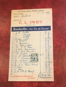
 Surrey Hills Historical Society Collection
Document - Account, C. L. Swift order docket re Mrs Matthews. 21/8/1957
... Together they ran the grocery store at 10 Croydon Road from 1949 until some time after 1954. In the 1980s they were living in Highbury Road, East Burwood and Clive was working for Unigate (later Bonlac) in a managerial position. ...Together they ran the grocery store at 10 Croydon Road from 1949 until some time after 1954. In the 1980s they were living in Highbury Road, East Burwood and Clive was working for Unigate (later Bonlac) in a managerial position. ...Clive Leslie Swift (RAAF 430415) was born in Elsternwick in 1924 and served in the RAAF in Borneo during WW2. He was mentioned in dispatches. He married Enid (Ina) Mary Smith in 1947. Together they ran the grocery store at 10 Croydon Road from 1949 until some time after 1954. In the 1980s they were living in Highbury Road, East Burwood and Clive was working for Unigate (later Bonlac) in a managerial position. (REF: Oral testimony, Libby Wilson, Canterbury History Group). The shop continued after the Swifts left but was later destroyed by fire. Clive Swift died in March 2014. This and other dockets were tucked into Ruth Matthews' recipe folder. Ruth and Harold Geoffrey (Geoff) Matthews lived at 42 Guildford Road, Surrey Hills. The donor recalled that her paternal grandmother (Ethel May Matthews) also occasionally shopped at the Swifts' shop as it was closer to her home (31 Guildford Road) than either than Griffith’s on Union Road or Thomas’ on Maling Road . Dockets such as these are reflective of shopping in the pre-supermarket era when women generally walked to the local shop or had proprietors or a staff member come to the house to take weekly orders. A pre-printed grocery docket for C. L. Swift (Late R.A.A.F.) on cream (slightly discoloured) paper printed in black, red and blue filled in with 19 hand-written items, their prices and the total of the grocery order. A green and cream duty stamp to the value of 3d is attached and over-signed with initials as having been paid. Order was for Mrs Matthews of Guildford Road.clive leslie swift, miss enid (ina) mary smith, mrs enid (ina) mary swift, croydon road, guildford road, grocery store, docket, accounts, bushells tea, mrs ruth matthews, harold geoffrey matthews, 'geoff' matthews -
 Whitehorse Historical Society Inc.
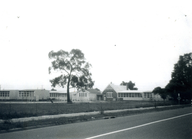
Photograph - B/W photograph, East Burwood State School East Burwood, 1971
... Black and White Photo of East Burwood State School, Corner Highbury and Blackburn Roads....Whitehorse Historical Society Inc. 2-10 Deep Creek Road Mitcham melbourne east burwood state school Schools Black and White Photo of East Burwood State School, Corner Highbury and Blackburn Roads. ...Black and White Photo of East Burwood State School, Corner Highbury and Blackburn Roads.east burwood state school, schools -
Whitehorse Historical Society Inc.
Pamphlet, Parks and reserves, 1/09/1999 12:00:00 AM
... Whitehorse Historical Society Inc. 2-10 Deep Creek Road Mitcham melbourne Parks and reserves Yarran Dheran Wattle Park Mullum Mullum Creek Schwerkolt Cottage Slater Reserve Trove Park Vermont Reserve Wandinong Sanctuary Walker Park Antonio Park Mitcham Bellbird Dell Blackburn Lake Sanctuary Bushy Creek Reserve Cootamundra Walk Burwood East Reserve Campbells Croft Hale Property Halliday Park Highbury Park Joseph Street Reserve Morack Golf Course Reports held in the Local History Collection, Nunawading Library, 3rd edition. ...Reports held in the Local History Collection, Nunawading Library, 3rd edition.Reports held in the Local History Collection, Nunawading Library, 3rd edition.Reports held in the Local History Collection, Nunawading Library, 3rd edition.parks and reserves, yarran dheran, wattle park, mullum mullum creek, schwerkolt cottage, slater reserve, trove park, vermont reserve, wandinong sanctuary, walker park, antonio park, mitcham, bellbird dell, blackburn lake sanctuary, bushy creek reserve, cootamundra walk, burwood east reserve, campbells croft, hale property, halliday park, highbury park, joseph street reserve, morack golf course -
 Whitehorse Historical Society Inc.
Map, Shire of Nunawading 1888
... road...burwood east...highbury...Whitehorse Historical Society Inc. 2-10 Deep Creek Road Mitcham melbourne shire of nunawading. south riding south boundary road burwood east highbury road springvale road mahoneys road forest hill holland road blackburn south burwood highway Plan showing owners of land in the South Riding of the Shire of Nunawading, 1888. ...Plan showing owners of land in the South Riding of the Shire of Nunawading, 1888. South Boundary Road is now Highbury Road.shire of nunawading. south riding, south boundary road, burwood east, highbury road, springvale road, mahoneys road, forest hill, holland road, blackburn south, burwood highway -
 Whitehorse Historical Society Inc.
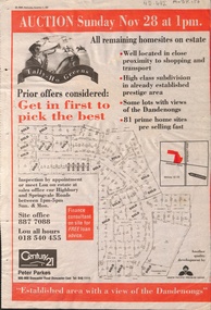
Newspaper - Article, Tally Ho Greens, 17/11/1993
... road...burwood east...highbury...Whitehorse Historical Society Inc. 2-10 Deep Creek Road Mitcham melbourne Bordered by Springvale Road and Highbury Road, 28-11-1993. auctions springvale road burwood east highbury road robinson drive hoadley crescent betts way trainor place sutton court cole close mcclelland way kennard place vision drive Advertisement in the Post for auction of 81 home sites on the Tally Ho Estate. ...Advertisement in the Post for auction of 81 home sites on the Tally Ho Estate.Advertisement in the Post for auction of 81 home sites on the Tally Ho Estate bordered by Springvale Road and Highbury Road, 28-11-1993.Advertisement in the Post for auction of 81 home sites on the Tally Ho Estate. auctions, springvale road, burwood east, highbury road, robinson drive, hoadley crescent, betts way, trainor place, sutton court, cole close, mcclelland way, kennard place, vision drive -
Whitehorse Historical Society Inc.
Map, Aerial photograph, c1950
... Aerial photo of Vermont South and Burwood East, Middleborough Road, Burwood Highway, Springvale Road, Highbury Road and environs....Whitehorse Historical Society Inc. 2-10 Deep Creek Road Mitcham melbourne vermont south burwood east aerial photographs Arial photo of Vermont South and Burwood East, Middleborough Road, Burwood Highway, Springvale Road, Highbury Road and environs. ...Arial photo of Vermont South and Burwood East, Middleborough Road, Burwood Highway, Springvale Road, Highbury Road and environs.Aerial photo of Vermont South and Burwood East, Middleborough Road, Burwood Highway, Springvale Road, Highbury Road and environs.Arial photo of Vermont South and Burwood East, Middleborough Road, Burwood Highway, Springvale Road, Highbury Road and environs.vermont south, burwood east, aerial photographs -
Whitehorse Historical Society Inc.
Document, History of Burwood East State School, 1/03/1969
... Document on Burwood East Primary School, originally a non-vested school, no 184 Harkaway, located at the junction of Highbury and Blackburn Roads whose first building was erected in 1861....Whitehorse Historical Society Inc. 2-10 Deep Creek Road Mitcham melbourne Burwood East Primary School No. 454 Nunawading Common School No 454 Document on Burwood East Primary School, originally a non-vested school, no 184 Harkaway, located at the junction of Highbury and Blackburn Roads whose first building was erected in 1861. ...Document on Burwood East Primary School, originally a non-vested school, no 184 Harkaway, located at the junction of Highbury and Blackburn Roads whose first building was erected in 1861.burwood east primary school no. 454, nunawading common school no 454 -
 Whitehorse Historical Society Inc.
Photograph - B/W Photograph, Burwood East State School No 454
... Road Mitcham melbourne The school was started in 1861 by the Anglican Church and was known as Harkaway. At that time the area was heavily timbered and supported market gardens, orchards and timber cutters. The school became Burwood East in 1902. burwood east state school No:454 This photograph shows the wooden building that was the Burwood State School up until it was moved to the present location on the corner of Highbury and Blackburn Roads. ...The school was started in 1861 by the Anglican Church and was known as Harkaway. At that time the area was heavily timbered and supported market gardens, orchards and timber cutters. The school became Burwood East in 1902.This photograph shows the wooden building that was the Burwood State School up until it was moved to the present location on the corner of Highbury and Blackburn Roads.burwood east state school, no:454