Showing 3396 items matching "highway"
-
 Glen Eira Historical Society
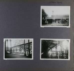
Album - Album page, 31 Nepean Highway, Circa 1972
... 31 Nepean Highway...Page 140 of Photograph Album with three (landscape) photographs of Roseneath on Nepean Highway. ...Handwritten: 31 Nepean Highway [top right] / 140 [bottom right]...31 Nepean Highway, Elsternwick, Melbourne, Victoria, Australia..."Roseneath" compares with "Cumbernauld" (pre 1872) at 504 Hawthorn Road and "Glenmoore" (1870) at 1 St Georges Road. trevor hart verandah chimneys porch decorative brackets single storey cast iron columns return verandah garden nepean highway roseneath italianate 1870's elsternwick cast iron work victorian style polychrome bricks william millar slate roofs brick houses house names Handwritten: 31 Nepean Highway [top right] / 140 [bottom right] Page 140 of Photograph Album with three (landscape) photographs of Roseneath on Nepean Highway. 31 Nepean Highway Album Album page ...This photograph is part of the Caulfield Historical Album 1972. This album was created in approximately 1972 as part of a project by the Caulfield Historical Society to assist in identifying buildings worthy of preservation. The album is related to a Survey the Caulfield Historical Society developed in collaboration with the National Trust of Australia (Victoria) and Caulfield City Council to identify historic buildings within the City of Caulfield that warranted the protection of a National Trust Classification. Principal photographer thought to be Trevor Hart, member of Caulfield Historical Society. Most photographs were taken between 1966-1972 with a small number of photographs being older and from unknown sources. All photographs are black and white except where stated, with 386 photographs over 198 pages. Victorian Heritage Database - HO48 - 31 Nepean Highway Elsternwick https://vhd.heritagecouncil.vic.gov.au/places/35531 (at 15/08/2021) "Roseneath" at 31 Point Nepean Road is a bi-chromatic Italianate villa built for William Millar in 1874. It is aesthetically and historically important. "Roseneath's aesthetic value derives from its survival as a substantially intact bi-chromatic brick villa, distinguished by the symmetrical north and south facing bays and by its spacious grounds. Its historical value rests on its comparatively early date and link with Shire councillor William Millar. The choice of bi-chromatic brick, which was highly fashionable at the time, is also of note. "Roseneath" compares with "Cumbernauld" (pre 1872) at 504 Hawthorn Road and "Glenmoore" (1870) at 1 St Georges Road.Page 140 of Photograph Album with three (landscape) photographs of Roseneath on Nepean Highway. Handwritten: 31 Nepean Highway [top right] / 140 [bottom right]trevor hart, verandah, chimneys, porch, decorative brackets, single storey, cast iron columns, return verandah, garden, nepean highway, roseneath, italianate, 1870's, elsternwick, cast iron work, victorian style, polychrome bricks, william millar, slate roofs, brick houses, house names -
 Charlton Golden Grains Museum Inc
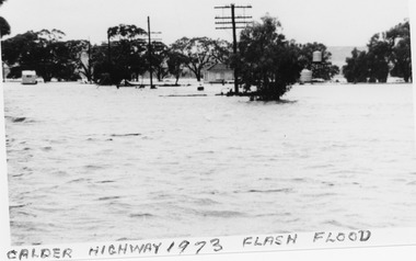
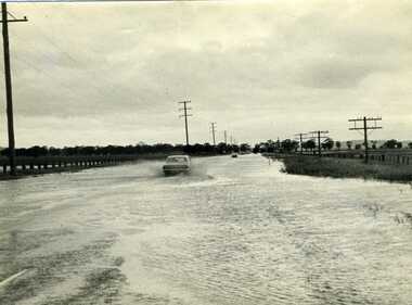
Photograph, B/W photograph 1973 Flash Flood on Calder Highway
... B/W photograph 1973 Flash Flood on Calder Highway...1973 Flash Flood on Calder Highway...Unframed B/W photograph 1973 Flash Flood on Calder Highway...Flood Calder Highway, Flash flood...Charlton Golden Grains Museum Inc 1 High Street Charlton goldfields 1973 Flash Flood on Calder Highway Charlton Calder Highway Floods Flood Calder Highway, Flash flood Unframed B/W photograph 1973 Flash Flood on Calder Highway B/W photograph 1973 Flash Flood on Calder Highway Photograph Photograph ...1973 Flash Flood on Calder HighwayUnframed B/W photograph 1973 Flash Flood on Calder HighwayFlood Calder Highway, Flash floodcharlton, calder highway, floods -
 Whitehorse Historical Society Inc.
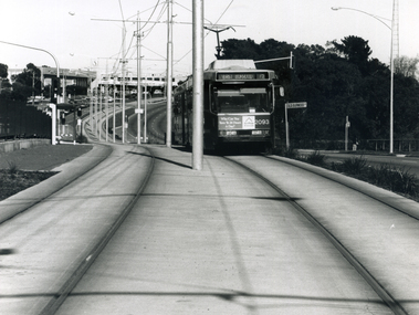
Photograph - B/W Photograph, Tram on Burwood Highway East Burwood, 1994
... Tram on Burwood Highway East Burwood...Black and white photograph of a tram on the Burwood Highway, coming east from the Middleborough intersection and shopping centre. 1994...Burwood Highway near Middleborough Road...Whitehorse Historical Society Inc. 2-10 Deep Creek Road Mitcham melbourne burwood highway blackburn south trams Black and white photograph of a tram on the Burwood Highway, coming east from the Middleborough intersection and shopping centre. 1994 Tram on Burwood Highway East Burwood Photograph B/W Photograph ...Black and white photograph of a tram on the Burwood Highway, coming east from the Middleborough intersection and shopping centre. 1994burwood highway blackburn south, trams -
 Charlton Golden Grains Museum Inc
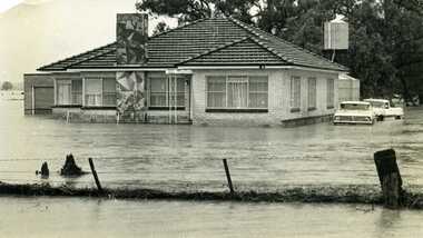
Photograph, Cameron, Ian, 1973 Flood W. Fitzpatrick's House on Calder Highway, Feb 1973
... Fitzpatrick's House on Calder Highway...W Fitzpatrick's house on Calder Highway surrounded by flood water from flooded Yeungroon Creek....Calder Highway, Charlton, Victoria, Australia...Fitzpatrick's House on Calder Highway Photograph Photograph Cameron, Ian Charlton Tribune ...1973 flood. W. Fitzpatrick's house on Calder Hwy, surrounded by flood water from Yeungroon Creek.B/W photograph of 1973 flood. W Fitzpatrick's house on Calder Highway surrounded by flood water from flooded Yeungroon Creek.charlton, calder highway, yeungroon, floods -
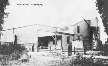 Ringwood and District Historical Society
Photograph, Ringwood Cool Store, corner of Wantirna Road and Maroondah Highway, Ringwood - c.1920s
... Ringwood Cool Store, corner of Wantirna Road and Maroondah Highway, Ringwood - c.1920s....Old Coolstores in Maroondah Highway, corner Wantirna Road...Typed below photograph, "Old Coolstores in Maroondah Highway, corner Wantirna Rd." Written on photograph, "Cool Store, Ringwood"....Old Coolstores in Maroondah Highway, corner Wantirna Road Ringwood Cool Store, corner of Wantirna Road and Maroondah Highway, Ringwood - c.1920s. ...Old Coolstores in Maroondah Highway, corner Wantirna RoadTyped below photograph, "Old Coolstores in Maroondah Highway, corner Wantirna Rd." Written on photograph, "Cool Store, Ringwood".coolstore -
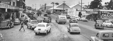 Ringwood and District Historical Society
Photograph, Maroondah Highway West, Ringwood, 1955. Saturday morning shopping in Maroondah Highway
... Maroondah Highway West, Ringwood, 1955. Saturday morning shopping in Maroondah Highway....Black and white photograph of shopping area along Maroondah Highway. Coolstores in background. (2 copies)...Typed below photograph: "Saturday morning shopping in Maroondah Highway looking towards corner of Wantirna Rd. with old coolstores in background. 1955. ...Black and white photograph of shopping area along Maroondah Highway. Coolstores in background. (2 copies) Maroondah Highway West, Ringwood, 1955. ...Black and white photograph of shopping area along Maroondah Highway. Coolstores in background. (2 copies)Typed below photograph: "Saturday morning shopping in Maroondah Highway looking towards corner of Wantirna Rd. with old coolstores in background. 1955. Written on back of loose photograph, "Wantirna Rd. between Ibbotson's and coolstore.coolstore -
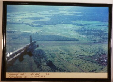 National Vietnam Veterans Museum (NVVM)
Photograph - A Framed Coloured Photograph, 'Highway One' Nui Dat 1970. Photographed by J.C. Mercieca, c.1970
... 'Highway One' Nui Dat 1970. Photographed by J.C. ...A colour photograph in a black frame titled "Highway One" Nui Dat 1970. Below the part of the helicopter that is in the photograph you can see the lush green landscape...."Highway One" Nui Dat 1970 Photographed by J.C. ...Cpl Joseph Charles Mercieca A316866 Royal Australian Air Force No.1 Operational Support Unit Photograph Highway one Nui Dat "Highway One" Nui Dat 1970 Photographed by J.C. ...This photograph was taken by Cpl Joseph Charles Mercieca (A316866) who served with the Royal Australian Air Force. He served in Vietnam with No. 1 Operational Support Unit from July 1969 to July 1970.A colour photograph in a black frame titled "Highway One" Nui Dat 1970. Below the part of the helicopter that is in the photograph you can see the lush green landscape."Highway One" Nui Dat 1970 Photographed by J.C. Merciecacpl joseph charles mercieca, a316866, royal australian air force, no.1 operational support unit, photograph, highway one, nui dat -
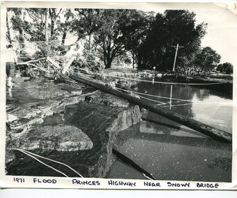 Orbost & District Historical Society
black and white photograph, February 1971
... This photograph was taken near the Snowy River Bridge on the the old Princes Highway in Orbost, near the caravan park. The 1971 flood was the the worst flood on record. ...A black / white photograph of debris, fallen power lines, a tree across the highway and floodwaters across the road....on front at bottom - handwritten in upper case print - " 1971 FLOOD PRINCES HIGHWAY NEAR SNOWY BRIDGE"...Princes Highway, Orbost, e, Victoria, Australia...Orbost & District Historical Society Ruskin Street Orbost gippsland This photograph was taken near the Snowy River Bridge on the the old Princes Highway in Orbost, near the caravan park. The 1971 flood was the the worst flood on record. ...This photograph was taken near the Snowy River Bridge on the the old Princes Highway in Orbost, near the caravan park. The 1971 flood was the the worst flood on record. At Jarrahmond it was at least 11 metres and up to one and a half kilometres wide on the flats causing enormous damage to the flood plain. Records say that "The brown floodwater stain in Bass Strait could be seen from passing airliners." Considerable damage was done to railway infrastructure, roads and farms. More information from the APRIL, 2008 newsletter by John Phillips. (see orbosthistory.com.au)This is pictorial evidence of a significant local event. Floods have been an integral part of Orbost's history for hundreds of years.A black / white photograph of debris, fallen power lines, a tree across the highway and floodwaters across the road.on front at bottom - handwritten in upper case print - " 1971 FLOOD PRINCES HIGHWAY NEAR SNOWY BRIDGE"floods-orbost-1971 -
 Ringwood and District Historical Society
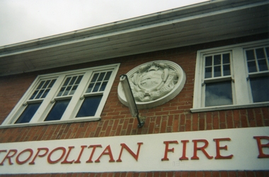
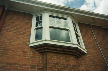
Photographs, Ringwood Fire Station at 255 Maroondah Highway circa 1998
... Ringwood Fire Station at 255 Maroondah Highway circa 1998...This fire station was closed and a new one opened on Maroondah Highway on the site of the old miner's cottage near the corner of the Highway and Mt Dandenong Road....Five coloured photographs of the Ringwood fire station at 255 Maroondah Highway and of the fireman's house when it was sold. ...Ringwood and District Historical Society 125A Warrandyte Road Ringwood North melbourne This fire station was closed and a new one opened on Maroondah Highway on the site of the old miner's cottage near the corner of the Highway and Mt Dandenong Road. ...This fire station was closed and a new one opened on Maroondah Highway on the site of the old miner's cottage near the corner of the Highway and Mt Dandenong Road.Five coloured photographs of the Ringwood fire station at 255 Maroondah Highway and of the fireman's house when it was sold. It later became 'The Fire Station Restaurant.' -
 Ringwood and District Historical Society
Photograph, Ringwood Fire Station at 255 Maroondah Highway circa 1998, Feb-98
... Ringwood Fire Station at 255 Maroondah Highway circa 1998...This fire station was closed and a new one opened on Maroondah Highway on the site of the old miner's cottage near the corner of the Highway and Mt Dandenong Road....Five coloured photographs of the Ringwood fire station at 255 Maroondah Highway and of the fireman's house when it was sold. ...Ringwood and District Historical Society 125A Warrandyte Road Ringwood North melbourne This fire station was closed and a new one opened on Maroondah Highway on the site of the old miner's cottage near the corner of the Highway and Mt Dandenong Road. ...This fire station was closed and a new one opened on Maroondah Highway on the site of the old miner's cottage near the corner of the Highway and Mt Dandenong Road.Five coloured photographs of the Ringwood fire station at 255 Maroondah Highway and of the fireman's house when it was sold. It later became 'The Fire Station Restaurant.' -
 Ringwood and District Historical Society
Photograph, Maroondah Highway Central, Ringwood. Ringwood Town Hall c1930s
... Maroondah Highway Central, Ringwood. Ringwood Town Hall c1930s...2 copies of Black and White Photograph (one large, one small) of Ringwood Town Hall, with bushes in front in centre strip of Maroondah Highway. Similar to VC#796 but possibly later. ...Image of Ringwood Town Hall, with bushes in front in centre strip of Maroondah Highway....Ringwood and District Historical Society 125A Warrandyte Road Ringwood North melbourne Image of Ringwood Town Hall, with bushes in front in centre strip of Maroondah Highway. 2 copies of Black and White Photograph (one large, one small) of Ringwood Town Hall, with bushes in front in centre strip of Maroondah Highway. ...2 copies of Black and White Photograph (one large, one small) of Ringwood Town Hall, with bushes in front in centre strip of Maroondah Highway. Similar to VC#796 but possibly later. Image of Ringwood Town Hall, with bushes in front in centre strip of Maroondah Highway. -
 City of Kingston
Photograph - Digital image, Black and white, Roads - Junction of Nepean Highway and South Road, c. 1950
... Roads - Junction of Nepean Highway and South Road...Junction of Nepean Highway and South Road, Moorabbin - Moorabbin Hotel on right. ...Black and white image of Nepean Highway and South Road junction point of view from Kingston Town Hall...City of Kingston Parkdale Library 96 Parkers Road, Parkdale Parkdale Junction of Nepean Highway and South Road, Moorabbin - Moorabbin Hotel on right. ...Junction of Nepean Highway and South Road, Moorabbin - Moorabbin Hotel on right. Shops in centre demolished for road widening in 1980'sBlack and white image of Nepean Highway and South Road junction point of view from Kingston Town HallPrinted in black text a round white sticker: 234 Handwritten in red ink 80% Yellow post it note written in blue ink: CHAP 7 234 / - Nepean Hwy + South Roadnepean highway, south road, moorabbin, moorabbin hotel -
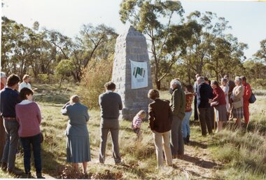 Stawell Historical Society Inc
Photograph, Major Mitchell restored plaque unveiling on the Western Highway
... Major Mitchell restored plaque unveiling on the Western Highway...Unveiling of restored Major Mitchell plaque on Western Highway...Acting Mayor of Stawell: Frank Jeffrey unvieling of the Major Mitchell plaque on the western highway near Stawell 150 years after Major Mitchell had passed this spot....Stawell Historical Society Inc 46 Longfield St Stawell grampians Unveiling of restored Major Mitchell plaque on Western Highway Stawell Acting Mayor of Stawell: Frank Jeffrey unvieling of the Major Mitchell plaque on the western highway near Stawell 150 years after Major Mitchell had passed this spot. ...Unveiling of restored Major Mitchell plaque on Western HighwayActing Mayor of Stawell: Frank Jeffrey unvieling of the Major Mitchell plaque on the western highway near Stawell 150 years after Major Mitchell had passed this spot.stawell -
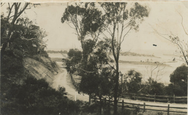 Lakes Entrance Historical Society
Postcard - Princes Highway around Jemmy's Point
... Princes Highway around Jemmy's Point... Princes Highway around Jemmy's Point . Unsealed road and post and rail fence. ...Black and white photograph of Princes Highway around Jemmy's Point . Unsealed road and post and rail fence. ...Bullock Island and the entrance in the distance Princes Highway around Jemmy's Point Postcard Princes Highway around Jemmy's Point ...Princes Highway around Jemmy's Point . Unsealed road and post and rail fence. Bullock Island and the entrance in the distance c1925Black and white photograph of Princes Highway around Jemmy's Point . Unsealed road and post and rail fence. Bullock Island and the entrance in the distance waterways, topography, islands, roads and streets -
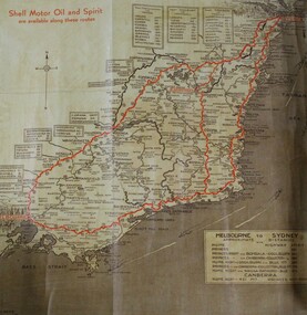 Wodonga & District Historical Society Inc
Map - Hamilton-Smith Collection Highway Map mid 1900s
... Hamilton-Smith Collection Highway Map mid 1900s......highway...A brown and tan highway map with red road markings showing the south east of Australia from Melbourne to Sydney ...It contributes to our understanding of social life in mid-twentieth century Wodonga, as well as providing interpretative capacity for themes including local history and social history. map highway wodonga melbourne sydney travel hamilton-smith hamilton-smith collection driving drive car road A brown and tan highway map with red road markings showing the south east of Australia from Melbourne to Sydney Hamilton-Smith Collection Highway Map mid 1900s Map Hamilton-Smith Collection Highway Map mid 1900s ...The Hamilton-Smith collection was donated by the children of Grace Mary Hamilton-Smith nee Ellwood (1911-2004) and William John (Jack) Hamilton-Smith (1909-1984) who settled in Wodonga in the 1940s. The Ellwood family had lived in north-east Victoria since the late 1800s. Grace’s mother, Rosina Ellwood nee Smale, was the first teacher at Baranduda in 1888, and a foundation member of the C.W.A. Rosina and her husband Mark retired to Wodonga in 1934. Grace and John married at St. David’s Church, Albury in 1941. John was a grazier, and actively involved in Agricultural Societies. The collection contains significant items which reflect the local history of Wodonga, including handmade needlework, books, photographs, a wedding dress, maps, and material relating to the world wars.This item has well documented provenance and a known owner. It forms part of a significant and representative historical collection which reflects the local history of Wodonga. It contributes to our understanding of social life in mid-twentieth century Wodonga, as well as providing interpretative capacity for themes including local history and social history.A brown and tan highway map with red road markings showing the south east of Australia from Melbourne to Sydney map, highway, wodonga, melbourne, sydney, travel, hamilton-smith, hamilton-smith collection, driving, drive, car, road -
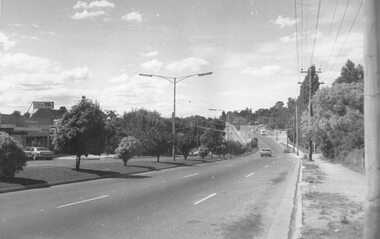 Ringwood and District Historical Society
Photograph, Maroondah Highway East, Ringwood in 1973. Eastward view along Maroondah Highway towards Mount Dandenong Road
... Maroondah Highway East, Ringwood in 1973. Eastward view along Maroondah Highway towards Mount Dandenong Road. ...Typed on back of photograph: "Maroondah Highway by the lake. Looking east towards Mt. ...Ringwood Lake is on the right hand side of the highway. Black and white photograph Maroondah Highway East, Ringwood in 1973. ...Black and white photographTyped on back of photograph: "Maroondah Highway by the lake. Looking east towards Mt. Dandenong Rd. - 1973". Ringwood Lake is on the right hand side of the highway. -
 Charlton Golden Grains Museum Inc
Photograph, Charlton Tribune, B/W photograph of 1971 flood, Nov 1971
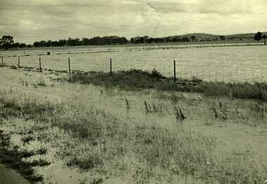
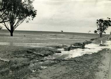
... Paddocks and roadside along Calder Highway....Paddocks and roadside along Calder Highway....Calder Highway, Charlton, Victoria, Australia...Paddocks and roadside along Calder Highway. Charlton Calder Highway Floods Unframed photograph of 1971 flood. ...1971 flood at Charlton. Paddocks and roadside along Calder Highway.Unframed photograph of 1971 flood. Paddocks and roadside along Calder Highway.charlton, calder highway, floods -
 Melton City Libraries
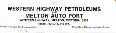
Archive, Western Highway Petroleum, Unknown
... Western Highway Petroleum...Advertisement of Western Highway Petroleum, business previously located on Western Highway, Melton. ...Melton City Libraries 31 McKenzie Street Melton melbourne Local Identities Advertisement of Western Highway Petroleum, business previously located on Western Highway, Melton. ...Advertisement of Western Highway Petroleum, business previously located on Western Highway, Melton. local identities -
 Stawell Historical Society Inc
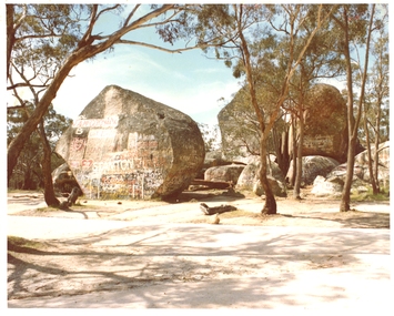
Photograph, Pleasant Creek Special School, Sister Rocks, Western Highway Stawell Nov 1975, Nov 1975
... Sister Rocks, Western Highway Stawell Nov 1975...Western Highway ...Part of socializing students for leaving the training centre. education tourism Western Highway Sister Rocks, Western Highway Stawell Nov 1975 Photograph Pleasant Creek Special School ...Photographs taken by teacher at Pleasant Creek Training Centre to help train students in living skills and becoming familiar with what shops sold. Part of socializing students for leaving the training centre.Western Highway education, tourism -
 Ringwood and District Historical Society
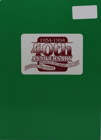
Book, 40th Anniversary - Ringwood Secondary College, Ringwood High School, 1954-1994, 1994
... Highway Press, Knoxfield...Ringwood and District Historical Society 125A Warrandyte Road Ringwood North melbourne Soft covered booklet of photographs and recollections over four decades 1954-1994. 40th Anniversary - Ringwood Secondary College, Ringwood High School, 1954-1994 Book Book Highway Press, Knoxfield ...Soft covered booklet of photographs and recollections over four decades 1954-1994. -
 Ringwood and District Historical Society
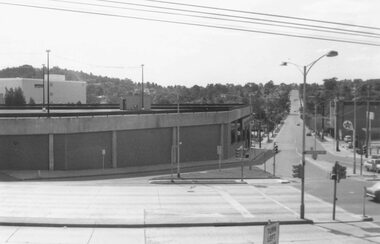
Photograph, Maroondah Highway Central, Ringwood. Carpark on corner of Highway and Warrandyte Road. 1976
... Maroondah Highway Central, Ringwood. Carpark on corner of Highway and Warrandyte Road. 1976....Image shows Warrandyte Road looking north from Maroondah Highway....Ringwood and District Historical Society 125A Warrandyte Road Ringwood North melbourne Image shows Warrandyte Road looking north from Maroondah Highway. Black and white photograph Maroondah Highway Central, Ringwood. ...Black and white photographImage shows Warrandyte Road looking north from Maroondah Highway. -
 Ringwood and District Historical Society
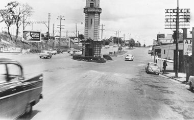
Photograph, Maroondah Highway Central, Ringwood. Clock tower at intersection of Warrandyte Road and Highway, c1960's
... Maroondah Highway Central, Ringwood. Clock tower at intersection of Warrandyte Road and Highway, c1960's.... Image shows Maroondah Highway looking west from Warrandyte Road....Ringwood and District Historical Society 125A Warrandyte Road Ringwood North melbourne Image shows Maroondah Highway looking west from Warrandyte Road. Black and white photograph (2 copies) Maroondah Highway Central, Ringwood. ...Black and white photograph (2 copies) Image shows Maroondah Highway looking west from Warrandyte Road. -
 Melbourne Tram Museum
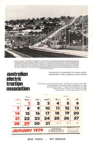
Document - Calendar, AETA 1979 featuring the new Burwood Highway tram line
... AETA 1979 featuring the new Burwood Highway tram line....The MMTB photo features Z25 inbound on Burwood Highway. The caption gives a description of the project....Australian Electric Traction Association (AETA) Calendar for 1979, featuring a photograph of Burwood Highway with Z class tram 25. Gives contact details for the AETA divisions. ...Calendars AETA Z class Burwood Highway new tramway tram 25 Australian Electric Traction Association (AETA) Calendar for 1979, featuring a photograph of Burwood Highway with Z class tram 25. ...The AETA published calendars on an annual basis through to 2005, promoting electric transport in Public Transport. The MMTB photo features Z25 inbound on Burwood Highway. The caption gives a description of the project.Yields information about the AETA promotional activities.Australian Electric Traction Association (AETA) Calendar for 1979, featuring a photograph of Burwood Highway with Z class tram 25. Gives contact details for the AETA divisions. Stapled to the sheet is a 12 sheet preprinted calendar for 1979 with various details of holidays etc. Printed on card with a punched hole on the top edge. calendars, aeta, z class, burwood highway, new tramway, tram 25 -
 Charlton Golden Grains Museum Inc
Photograph, Charlton Tribune, Flood Water damage to McGurk's fence, c. 1980
... Flood 1971, damage to Mc Gurk's fencing on Calder Highway....B/W photo of flood water & damage to McGurk's fence on Calder Highway in 1971 flood....Calder Highway, Charlton, Wimmera Mallee, Victoria, Australia...Charlton Golden Grains Museum Inc 1 High Street Charlton goldfields Flood 1971, damage to Mc Gurk's fencing on Calder Highway. Calder Highway Charlton Floods B/W photo of flood water & damage to McGurk's fence on Calder Highway in 1971 flood. ...Flood 1971, damage to Mc Gurk's fencing on Calder Highway.B/W photo of flood water & damage to McGurk's fence on Calder Highway in 1971 flood.calder highway, charlton, floods -
 Charlton Golden Grains Museum Inc
Photograph, Charlton Tribune, 1973 Flood, Nov 1971
... 1971 flood, Car driving through flood water on Calder Highway, Charlton, Victoria...Car driving through floodwater on Calder Highway....Calder Highway, Charlton, Victoria, Australia...Charlton Golden Grains Museum Inc 1 High Street Charlton goldfields 1971 flood, Car driving through flood water on Calder Highway, Charlton, Victoria Calder Highway Floods B/W photograph of 1971 flood. ...1971 flood, Car driving through flood water on Calder Highway, Charlton, VictoriaB/W photograph of 1971 flood. Car driving through floodwater on Calder Highway.calder highway, floods -
 Ringwood and District Historical Society
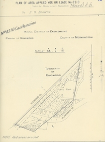
Map, Department of Mines, Plan of area applied for under the mining leases regulations in the township of Ringwood between Maroondah Highway and Mt. Dandenong Road. Mining District of Castlemaine, County of Mornington, Parish of Ringwood T Area 58(A) 2 (R)15(P) Acres, Roods, Perches. 1934, 20-Feb-34
... Plan of area applied for under the mining leases regulations in the township of Ringwood between Maroondah Highway and Mt. Dandenong Road. Mining District of Castlemaine, County of Mornington, Parish of Ringwood T Area 58(A) 2 (R)15(P) Acres, Roods, Perches. 1934...Map of the township of Ringwood with subdivisions between Maroondah Highway and Mt. Dandenong Road. the area applied for on lease No.8210 by E.G.Browne.Mining District of Castlemaine, County of Mornington, Parish of Ringwood T Area 58(A) 2 (R)15(P) Acres, Roods, Perches....Buff coloured sheet foolscap with black printing showing map of the township of Ringwood between Maroondah Highway and Mt. Dandenong Road. Mining District of Castlemaine, County of Mornington, Parish of Ringwood T Area 58(A) 2 (R)15(P) Acres, Roods, Perches +Additional Keywords: Browne E.G....Ringwood and District Historical Society 125A Warrandyte Road Ringwood North melbourne Map of the township of Ringwood with subdivisions between Maroondah Highway and Mt. Dandenong Road. the area applied for on lease No.8210 by E.G.Browne.Mining District of Castlemaine, County of Mornington, Parish of Ringwood T Area 58(A) 2 (R)15(P) Acres, Roods, Perches. ...Map of the township of Ringwood with subdivisions between Maroondah Highway and Mt. Dandenong Road. the area applied for on lease No.8210 by E.G.Browne.Mining District of Castlemaine, County of Mornington, Parish of Ringwood T Area 58(A) 2 (R)15(P) Acres, Roods, Perches.Buff coloured sheet foolscap with black printing showing map of the township of Ringwood between Maroondah Highway and Mt. Dandenong Road. Mining District of Castlemaine, County of Mornington, Parish of Ringwood T Area 58(A) 2 (R)15(P) Acres, Roods, Perches +Additional Keywords: Browne E.G. -
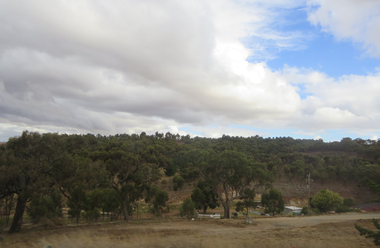
 Ballarat Heritage Services
Photographs - Colour, Clare Gervasoni, Settlement ner the Pentland Hills from the Western Highway, 2019, 31/03/2019
... Settlement ner the Pentland Hills from the Western Highway, 2019...Colour photograph from the Western Highway. ...Ballarat Heritage Services PO Box 2209 Bakery Hill Post Office goldfields pemtland hills Colour photograph from the Western Highway. Settlement ner the Pentland Hills from the Western Highway, 2019 Photographs - Colour Clare Gervasoni ...Colour photograph from the Western Highway. pemtland hills -
 Ballarat Heritage Services
Photographs - Colour, Clare Gervasoni, Parkside Settlement near the Pentland Hills from the Western Highway, 2019, 31/03/2019
... Parkside Settlement near the Pentland Hills from the Western Highway, 2019...Colour photograph from the Western Highway. ...Ballarat Heritage Services PO Box 2209 Bakery Hill Post Office goldfields pentland hills parkside Colour photograph from the Western Highway. Parkside Settlement near the Pentland Hills from the Western Highway, 2019 Photographs - Colour Clare Gervasoni ...Colour photograph from the Western Highway. pentland hills, parkside -
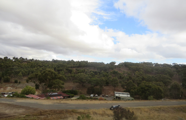 Ballarat Heritage Services
Photographs - Colour, Clare Gervasoni, Parkside Settlement near the Pentland Hills from the Western Highway, 2019, 31/03/2019
... Parkside Settlement near the Pentland Hills from the Western Highway, 2019...Colour photograph from the Western Highway. ...Ballarat Heritage Services PO Box 2209 Bakery Hill Post Office goldfields pentland hills parkside Colour photograph from the Western Highway. Parkside Settlement near the Pentland Hills from the Western Highway, 2019 Photographs - Colour Clare Gervasoni ...Colour photograph from the Western Highway. pentland hills, parkside