Showing 83 items matching "historic walk"
-
 Bendigo Historical Society Inc.
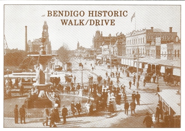
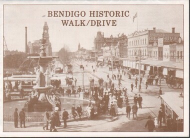
Document - BASIL MILLER COLLECTION: BENDIGO HISTORIC WALK/DRIVE, 1988
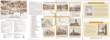
... BASIL MILLER COLLECTION: BENDIGO HISTORIC WALK/DRIVE...Tourist brochure titled, 'Bendigo Historic Walk/Drive, Bendigo and District Tourism Association. ...Document BASIL MILLER COLLECTION: BENDIGO HISTORIC WALK/DRIVE ...Tourist brochure titled, 'Bendigo Historic Walk/Drive, Bendigo and District Tourism Association. Details central business district historic buildings, (Shamrock Hotel, Post Office, etc). List of attractions on rear page.Crown Castleton Publishers, 6 Schumakers Lane, Maiden Gully, Victoria, 3551.person, individual, basil miller -
 Bendigo Historical Society Inc.
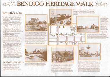
Flyer - Bendigo Historic Walk / Drive
... Bendigo Historic Walk / Drive...1988 Bendigo Historic Walk / Drive pamphlet. A3 quarter folded to show map of Bendigo and walking tour options to visit local buildings. ...Flyer Bendigo Historic Walk / Drive ...1988 Bendigo Historic Walk / Drive pamphlet. A3 quarter folded to show map of Bendigo and walking tour options to visit local buildings. Dual print in two colours (orange and brown) includes several images.walking tour, driving tour -
 Ringwood and District Historical Society
Pamphlet, Maroondah City Council, Ringwood Central - Historic Walk, c. 2000
... Ringwood Central - Historic Walk...Ringwood Central - Historic Walk. White bifold pamphlet with photographs (12) and map. ...Ringwood Central - Historic Walk Pamphlet Maroondah City Council ...Produced by Maroondah City Council, sponsored by the Maroondah Tourism Advisory Board from notes by courtesy of the Ringwood Archives.Ringwood Central - Historic Walk. White bifold pamphlet with photographs (12) and map. Explanatory text; 2 copies. -
 Tarnagulla History Archive
Clippings: Tarnagulla Historic Walk, circa 1960s-1980s
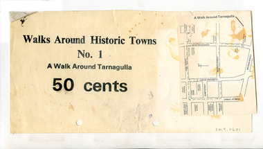
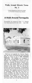
... Clippings: Tarnagulla Historic Walk...One has printed text "Walks Around Historic Towns No.1 A Walk Around Tarnagulla 50 Cents". ...Clippings: Tarnagulla Historic Walk ...Donald Clark Collection.Three paper clippings, stapled together. One has printed text "Walks Around Historic Towns No.1 A Walk Around Tarnagulla 50 Cents". The other two are a photo of the Tarnagulla Wesleyan Church and a map of Tarnagulla marked with highlights.tourism -
Tarnagulla History Archive
Pamphlet - Brochure: Tarnagulla Self-guided Tour, Walk Around Historic Towns: A Walk Around Tarnagulla, 1981
... Walk Around Historic Towns: A Walk Around Tarnagulla...Folded pamphlet entitled 'Walk Around Historic Towns: A Walk Around Tarnagulla'. ...Tarnagulla History Archive Tarnagulla Public Hall 69-71 Commercial Rd Tarnagulla goldfields Folded pamphlet entitled 'Walk Around Historic Towns: A Walk Around Tarnagulla'. ...Folded pamphlet entitled 'Walk Around Historic Towns: A Walk Around Tarnagulla'. Contains text content for a self-guided walking tour of Tarnagulla. -
 Bendigo Historical Society Inc.
Document - BASIL MILLER COLLECTION: BENDIGO HISTORIC WALK/DRIVE
... BASIL MILLER COLLECTION: BENDIGO HISTORIC WALK/DRIVE...Document BASIL MILLER COLLECTION: BENDIGO HISTORIC WALK/DRIVE ...One fold out sheet with a map and descriptions of points of interest at each nominated site.person, individual, basil miller -
Ringwood and District Historical Society
Booklet, Maroondah City Council - Tourism Advisory Board, Ringwood Central Historic Walk
... Ringwood Central Historic Walk...Ringwood and District Historical Society 125A Warrandyte Road Ringwood North melbourne Details of 12 buildings in Ringwood - Walk no 4 (circa1990s) Ringwood Central Historic Walk Booklet Maroondah City Council - Tourism Advisory Board ...Details of 12 buildings in Ringwood - Walk no 4 (circa1990s) -
 Healesville and District Historical Society
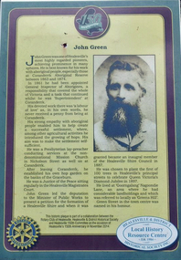
Sign - John Green & Coranderrk, Green Street - Healesville Historic Walk
... Green Street - Healesville Historic Walk...Green Street - Healesville Historic Walk Sign John Green & Coranderrk ...Information sign at corner of Green Street and Maroondah Highway, Healesville.See image. -
 Buninyong & District Historical Society
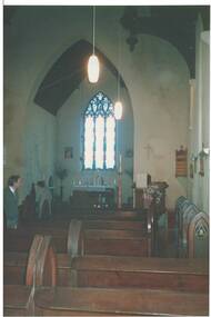
Photograph - Interior of Holy Trinity Church, Buninyong, Colour photograph of the interior of Holy Trinity Church, Buninyong, taken on an Historic Walk in 1988
... Colour photograph of the interior of Holy Trinity Church, Buninyong, taken on an Historic Walk in 1988....Original condition, rather dark and faded Colour photograph of the interior of Holy Trinity Church, Buninyong, taken on an Historic Walk in 1988. Photograph Interior of Holy Trinity Church, Buninyong. ...Original condition, rather dark and fadedchurch interiors., church furniture. -
 Narre Warren and District Family History Group
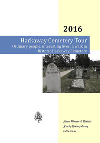
Book, Narre Warren & District Family History Group Inc, Ordinary people, interesting lives : a walk in historic Harkaway Cemetery, 2016
... Ordinary people, interesting lives : a walk in historic Harkaway Cemetery...Harkaway Cemetery A compilation of stories of local people and their families with connections to the Harkaway Cemetery Ordinary people, interesting lives : a walk in historic Harkaway Cemetery Book Narre Warren & District Family History Group Inc. ...A compilation of stories of local people and their families with connections to the Harkaway Cemeterynon-fictionA compilation of stories of local people and their families with connections to the Harkaway Cemeteryharkaway (vic.), harkaway cemetery -
Lakes Entrance Historical Society
Mixed media, Lakes Entrance Regional Historical Society, New Works Heritage Walk 1-12-2000, 2000
... ...Historic walk...Lakes Entrance Historical Society 4 Marine Parade Lakes Entrance gippsland Three events were held in 2000; The New Works Heritage walk, The cottage walk 1/12/2000 and the opening of the LERHS building 30/6/2000 Local History People Buildings Historic walk DVD recording events New Works Heritage Walk 1-12-2000 Mixed media Lakes Entrance Regional Historical Society ...Three events were held in 2000; The New Works Heritage walk, The cottage walk 1/12/2000 and the opening of the LERHS building 30/6/2000DVD recording eventslocal history, people, buildings, historic walk -
 Rutherglen Historical Society
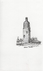
Ink sketch, Pat Robinson, Water Tower, c1990
... Ink sketches of Rutherglen landmarks and old buildings produced by local artist Pat Robinson for planned Historic Walk brochure (not used)...Rutherglen Historical Society Murray Street Rutherglen high-country Ink sketches of Rutherglen landmarks and old buildings produced by local artist Pat Robinson for planned Historic Walk brochure (not used) pat robinson buildings artist water tower wine bottle One of a series of black and white ink sketches, on paper, of Rutherglen landmarks. ...Ink sketches of Rutherglen landmarks and old buildings produced by local artist Pat Robinson for planned Historic Walk brochure (not used)One of a series of black and white ink sketches, on paper, of Rutherglen landmarks. This one showing the water tower with the structure that was added to the top to make it look like a wine bottle. pat robinson, buildings, artist, water tower, wine bottle -
Whitehorse Historical Society Inc.
Article, Cootamundra Walk, 3/08/1993 12:00:00 AM
... Walk...Historic Information...Whitehorse Historical Society Inc. 2-10 Deep Creek Road Mitcham melbourne Cootamundra Walk Historic Information Illustrated article from the Age 3/8/1993 Illustrated article from the Age 3/8/1993 Cootamundra Walk Article Article ...Illustrated article from the Age 3/8/1993Illustrated article from the Age 3/8/1993Illustrated article from the Age 3/8/1993cootamundra walk, historic information -
 Sunbury Family History and Heritage Society Inc.
Photograph, 21st August 1994
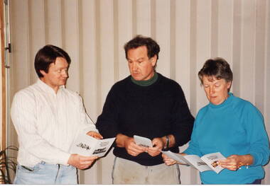
... It was a publication launched on the 21st Au8gust 1994, that highlighted four historic walks around the the old Sunbury township. ...It was a publication launched on the 21st Au8gust 1994, that highlighted four historic walks around the the old Sunbury township. ...The three people from L-R: Graham Gibb, Trevor Dunn and Wendy Sutherland were members of the Sunbury & District Heritage Association and were attending the launch of a booklet that the Association produced. It was a publication launched on the 21st Au8gust 1994, that highlighted four historic walks around the the old Sunbury township. The walks booklet was the first of a number of publications that the Association produced over the years, highlighting Sunbury's history.A non-digital coloured photograph of a lady and two men discussing a pamphlet.graham gibb, trevor dunn, wendy sutherland, sunbury walks, sunbury & district heritage association -
 Sunbury Family History and Heritage Society Inc.
Photograph, 12th August 1994
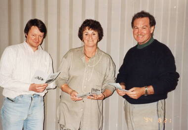
... They were photographed at the launch of publication of the booklet featuring Historic Walks around Sunbury, which the Association had compiled in 1994. ...They were photographed at the launch of publication of the booklet featuring Historic Walks around Sunbury, which the Association had compiled in 1994. ...The three people photographed were committee members of the former Sunbury & District Heritage Association. They are from L-R, Graham Gibb, Treasurer, Veronica Burgess, President and Trevor Dunn, Secretary. They were photographed at the launch of publication of the booklet featuring Historic Walks around Sunbury, which the Association had compiled in 1994. A non-digital coloured photograph of a lady and two men. Each person is holding a small booklet.sunbury & district heritage association, sunbury historic walks, graham gibb, veronica burgess, trevor dunn -
Lakes Entrance Historical Society
Map - New Works Historic Precinct and Lakes Entrance Walk
... New Works Historic Precinct and Lakes Entrance Walk ...Map of Lakes Entrance Walk and New Works Historic Precinct showing the walk and area pictures. 2 pages...Lakes Entrance Historical Society 4 Marine Parade Lakes Entrance gippsland Waterways Map of Lakes Entrance Walk and New Works Historic Precinct showing the walk and area pictures. 2 pages Map New Works Historic Precinct and Lakes Entrance Walk ...Map of Lakes Entrance Walk and New Works Historic Precinct showing the walk and area pictures. 2 pageswaterways -
 Port Melbourne Historical & Preservation Society
Booklet, Commemorating Port's Industrial History and Legacy, Feb 2011
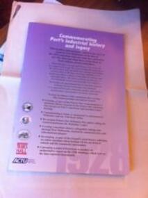
... Back cover has map of "historic watersiders Port Melbourne walk"...Back cover has map of "historic watersiders Port Melbourne walk" Commemorating Port's Industrial History and Legacy Booklet Maritime Union of Australia (MUA) ...Published to commemorate the anniversary of the 1928 waterfont lockout.Booklet with mauve background and black and white and dark red text. Back cover has map of "historic watersiders Port Melbourne walk"built environment, piers and wharves - princes pier, industrial disputes, allan whittaker, piers and wharves - waterside workers, maritime union of australia, mua, hogan's flat, beacon cove, james laurence murphy, george sangster -
 Tarnagulla History Archive
Walks Around Historic Towns, No 1 A Walk Around Tarnagulla, circa 1990s
... Walks Around Historic Towns, No 1 A Walk Around Tarnagulla...A photocopied foldable A4 brochure created to guide a walking tour. Title: Walks Around Historic Towns, No. 1, A Walk Around Tarnagulla. ...Features 13 places of interest around the town. Walks Around Historic Towns, No 1 A Walk Around Tarnagulla ...Donald Clark Collection.A photocopied foldable A4 brochure created to guide a walking tour. Title: Walks Around Historic Towns, No. 1, A Walk Around Tarnagulla. Features 13 places of interest around the town.tourism, local history, walking tours -
 Bendigo Historical Society Inc.
Document - BENDIGO HERITAGE WALK DOCUMENT
... Foldout A3 size tourist document 'Bendigo Heritage Walk' Documents historic buildings along a set heritage walk in the CBD area. ...History House 11 Mackenzie Street Bendigo goldfields BENDIGO Buildings heritage walk Bendigo heritage Foldout A3 size tourist document 'Bendigo Heritage Walk' Documents historic buildings along a set heritage walk in the CBD area. ...Foldout A3 size tourist document 'Bendigo Heritage Walk' Documents historic buildings along a set heritage walk in the CBD area. Destinations include Charing Cross, Dudley House, Hargreaves Mall, Law Courts, Alexandra Fountain, Rosalind park. Each destination has a history of the site described.bendigo, buildings, heritage walk, bendigo, heritage -
 Sunshine and District Historical Society Incorporated
Document - Keilor Parks and Sunshine Bus Tours
... Handwritten report Intro Tour NSLC 9 August 2000|Flyer Growers and Processors Keilor Valley Gardens|Typed report notes for Tour of Keilor 17 January 1996 U3A|Handwritten notes Keilor Tour 9 August 2000|Flyer Brimbank Park|Flyer Park News Horseshoe Bend Farm|Flyer Keilor Heritage Walk|Flyer Menu Keilor Hotel|Flyer Overnewton Castle|Typed Report Overnewton The Age 20 August 1971|Booklet Overnewton 1849 to 1999|Newspaper article July 2000 River water use block|Map of Keilor|Typed report Chronology compiled by Christine Laskowski History of Keilor|Flyer Brimbank Park Guide|Typed report Brimbank Bus Tour Handout 8th Oct 2012|Typed report Keilor Bus Tour 1 Tour Guides notes|Typed report Celebrating Sunshine 150 Heritage Bus Tours 7th and 14th December 2010|Typed detailed notes Bus Tours 7th and 14th December 2010|Typed report Bus Route 7th and 14th December 2010|Typed report Historic Walks 19 March 2011|Typed report Bus Tours 8 October 2012|Extract The Friends of McKay Gardens Oak Tree Walk|Typed report Watershed Region of Werribee River and Tributaries and Surrounding Watersheds|Newspaper article Sunshine Advocate 29 September 1989 Roll back in time|Typed report City of Brimbank Historical Tour Sunshine and Deer Park Section 17 March 1999|Typed report Brimbank History Tour Sunshine to Keilor|Typed report Tour of City of Sunshine|Flyer Heritage Trails Sunshine 150|Typed letter to Norm from Julie|Typed letter to Public Land and Policy Land Stewardship and Biodiversity regarding Submission Riverine Redgum Forests Investigation|Booklet Victorians National Parks Australia|Draft tour of Sunshine Braybrook Deer Park Ardeer Albion Sunshine South|Newspaper article The Advocate 3rd March 2004 - Shock that farm might be closed...Keilor Sunshine Handwritten report Intro Tour NSLC 9 August 2000|Flyer Growers and Processors Keilor Valley Gardens|Typed report notes for Tour of Keilor 17 January 1996 U3A|Handwritten notes Keilor Tour 9 August 2000|Flyer Brimbank Park|Flyer Park News Horseshoe Bend Farm|Flyer Keilor Heritage Walk|Flyer Menu Keilor Hotel|Flyer Overnewton Castle|Typed Report Overnewton The Age 20 August 1971|Booklet Overnewton 1849 to 1999|Newspaper article July 2000 River water use block|Map of Keilor|Typed report Chronology compiled by Christine Laskowski History of Keilor|Flyer Brimbank Park Guide|Typed report Brimbank Bus Tour Handout 8th Oct 2012|Typed report Keilor Bus Tour 1 Tour Guides notes|Typed report Celebrating Sunshine 150 Heritage Bus Tours 7th and 14th December 2010|Typed detailed notes Bus Tours 7th and 14th December 2010|Typed report Bus Route 7th and 14th December 2010|Typed report Historic Walks 19 March 2011|Typed report Bus Tours 8 October 2012|Extract The Friends of McKay Gardens Oak Tree Walk|Typed report Watershed Region of Werribee River and Tributaries and Surrounding Watersheds|Newspaper article Sunshine Advocate 29 September 1989 Roll back in time|Typed report City of Brimbank Historical Tour Sunshine and Deer Park Section 17 March 1999|Typed report Brimbank History Tour Sunshine to Keilor|Typed report Tour of City of Sunshine|Flyer Heritage Trails Sunshine 150|Typed letter to Norm from Julie|Typed letter to Public Land and Policy Land Stewardship and Biodiversity regarding Submission Riverine Redgum Forests Investigation|Booklet Victorians National Parks Australia|Draft tour of Sunshine Braybrook Deer Park Ardeer Albion Sunshine South|Newspaper article The Advocate 3rd March 2004 - Shock that farm might be closed Brimbank Park|Keilor Hotel|History of Keilor|Overnewton Castle|Horseshoe Bend Farm|Keilor Valley Gardens|Brimbank Bus Tour Document Keilor Parks and Sunshine Bus Tours ...Handwritten report Intro Tour NSLC 9 August 2000|Flyer Growers and Processors Keilor Valley Gardens|Typed report notes for Tour of Keilor 17 January 1996 U3A|Handwritten notes Keilor Tour 9 August 2000|Flyer Brimbank Park|Flyer Park News Horseshoe Bend Farm|Flyer Keilor Heritage Walk|Flyer Menu Keilor Hotel|Flyer Overnewton Castle|Typed Report Overnewton The Age 20 August 1971|Booklet Overnewton 1849 to 1999|Newspaper article July 2000 River water use block|Map of Keilor|Typed report Chronology compiled by Christine Laskowski History of Keilor|Flyer Brimbank Park Guide|Typed report Brimbank Bus Tour Handout 8th Oct 2012|Typed report Keilor Bus Tour 1 Tour Guides notes|Typed report Celebrating Sunshine 150 Heritage Bus Tours 7th and 14th December 2010|Typed detailed notes Bus Tours 7th and 14th December 2010|Typed report Bus Route 7th and 14th December 2010|Typed report Historic Walks 19 March 2011|Typed report Bus Tours 8 October 2012|Extract The Friends of McKay Gardens Oak Tree Walk|Typed report Watershed Region of Werribee River and Tributaries and Surrounding Watersheds|Newspaper article Sunshine Advocate 29 September 1989 Roll back in time|Typed report City of Brimbank Historical Tour Sunshine and Deer Park Section 17 March 1999|Typed report Brimbank History Tour Sunshine to Keilor|Typed report Tour of City of Sunshine|Flyer Heritage Trails Sunshine 150|Typed letter to Norm from Julie|Typed letter to Public Land and Policy Land Stewardship and Biodiversity regarding Submission Riverine Redgum Forests Investigation|Booklet Victorians National Parks Australia|Draft tour of Sunshine Braybrook Deer Park Ardeer Albion Sunshine South|Newspaper article The Advocate 3rd March 2004 - Shock that farm might be closedkeilor, sunshine -
Surrey Hills Historical Society Collection
Work on paper - Vertical file, Dairies
... Bowen family information used during a historic walk by N. Hiscox and D. Wisewould, 1988 (1 page). 26. ...Bowen family information used during a historic walk by N. Hiscox and D. Wisewould, 1988 (1 page). 26. ...1. Laurie & Alice Izod, interviewed June 2001 for the Burwood Bulletin; followed up by Jocelyn Hall; her typed notes (1 page). 2. ’70 years of togetherness’, Burwood Bulletin article about Laurie & Alice Izod (undated but from June 2001) (1 page). 3. Copy of certificate given to Vera Breedon, 1.1.1901 – a memento of inauguration of Commonwealth of Australia (1 page). 4. Death: C.H. Breedon, Argus, 15.1.1921 – sourced from Trove (1 page). 5. History of Breedon family and other notes about Surrey Hills from Horace Breedon, 1979, (2 pages). 6. Dairies by Horrie Breedon, 1980 (2 pages). 7. Towt’s dairy : 2 interviews with Jean Rae (nee Towt), one undated, other dated 1991 (2 pages). 8. Notes on the Kilpatrick family from a friend, undated (1 page). 9. Notes on the Kilpatrick family, dairy and house, 1988 (2 pages). 10. Notes on Cash family, undated (1 page). 11. Notes re Kenneally family, undated (1 page). 12. Notes on dairy in Robinson Street, undated (1 page). 13. And 2 generations back . . . . , undated (1 page). 14. Notes from Marie George, undated (1 page). 15. Snapshot of a local business, undated (1 page). 16. Costello family notes, undated (1 page). 17. Costello’s dairy, undated (1 page). 18. Herman Webb – conversation with Alan Holt c. 1986-7 (1 page). 19. Webb’s dairies – handwritten notes, undated (3 pages). 20. Webb’s dairy - typed copy of above notes, 1987 (1 page), and 3 pages of miscellaneous notes. 21. Details re Bignell Lone Pine Dairy photos; summary of interview by Sue Barnett with B., J. & D. Bignell 1997; and additional details 1996; and notes re contemporary photos of Lone Pine 1996-7 (3 pages). 22. 2 shop dockets – Lone Pine Dairy 1997 & 1999. 23. Photo of A.C. Bignell. 24. Bovill’s dairy: from Alan Holt’s records, undated (1 page). 25. Bowen family information used during a historic walk by N. Hiscox and D. Wisewould, 1988 (1 page). 26. Bovill family, undated (1 page). 27. Bowyer and Bovill family notes, May 1991 (3 pages). 28. Dairymen and dairies in Surrey Hills, by Alan Holt, undated (8 pages).Government Gazette specified dairies, 9.1.1948 (1 page). 29. Government Gazette specified dairies, 7.10.1963 (2 pages). -
Federation University Historical Collection
Document, Zelda Martin, Central Victorian Goldmining towns - Boom Towns or Ghost Towns?, c1996
... *Three articles published by Buninyong and District Historical Society Inc: (Magpie Exploration; Finding Gold In The Green Hills; Magpie Exploration; Burnt Bridge to Cargarie to Mt Mercer) *Copies of newspaper articles/items *Buninyong Street Directory Carisbrook: *In the Beginning There Was Carisbrook *The History of the Carisbrook Racecourse Carngham / Snake Valley: *Brief History *Directory Castlemaine: *Directory 1865-1866 - Alphabetical and Street *Poster - Castlemaine A Contemporary Guide "The Great Centre" 1866 - A Contemporary Guide to the Fascinating Past *Pamphlet - Castlemaine District Community Hospital *Map - Castlemaine, Maldon & Surrounding Districts *Map and Information - The Dry Diggings Track - a 55kl walk among historic goldfields relics ( Castlemaine Fryerstown Vaughan Mt Franklin Hepburn Daylesford) *Postcard - Former Court House *Directory 1867 - Alphabetical, Trade [.10] Resource No.3 Grey folder Titled Towns 3 Creswick to Maryborough Creswick: *Brief History *Booklet - "Creswick Cemetery Walk" *Booklet - The Buried Rivers of Gold Heritage Trail Creswick *Creswick Historical Museum Information Sheet *Chronological History of Creswick *Alphabetical Directory of the Borough of Creswick *Creswick's Creek Directory 1856 *Historic Creswick Walking Tour *A Brief Account of the Schools of Creswick - Past and Present *100 Years of Railway Travel in Creswick *The Berry Deep Leads *The Spence Home at Jackass Gully in the Creswick State Forest ( William Guthrie Spence - Pioneer) *The New Australian Mine and the 1882 Disaster *Creswick District News, Issue 7, July August 1999 *The Creswick Miners Walk - Information and Map *Maps Chewton: *Brief History *Directory Clunes: *Brief History *Clunes Street Directory Daylesford: *Brief History *Notable Bushfires in Daylesford District Over More Than a Century - "Black Thursday" 1851; 1862; 1899; the Disastrous Hepburn Fire of 1906; 1939; 1944; 1969. ...*Three articles published by Buninyong and District Historical Society Inc: (Magpie Exploration; Finding Gold In The Green Hills; Magpie Exploration; Burnt Bridge to Cargarie to Mt Mercer) *Copies of newspaper articles/items *Buninyong Street Directory Carisbrook: *In the Beginning There Was Carisbrook *The History of the Carisbrook Racecourse Carngham / Snake Valley: *Brief History *Directory Castlemaine: *Directory 1865-1866 - Alphabetical and Street *Poster - Castlemaine A Contemporary Guide "The Great Centre" 1866 - A Contemporary Guide to the Fascinating Past *Pamphlet - Castlemaine District Community Hospital *Map - Castlemaine, Maldon & Surrounding Districts *Map and Information - The Dry Diggings Track - a 55kl walk among historic goldfields relics ( Castlemaine Fryerstown Vaughan Mt Franklin Hepburn Daylesford) *Postcard - Former Court House *Directory 1867 - Alphabetical, Trade [.10] Resource No.3 Grey folder Titled Towns 3 Creswick to Maryborough Creswick: *Brief History *Booklet - "Creswick Cemetery Walk" *Booklet - The Buried Rivers of Gold Heritage Trail Creswick *Creswick Historical Museum Information Sheet *Chronological History of Creswick *Alphabetical Directory of the Borough of Creswick *Creswick's Creek Directory 1856 *Historic Creswick Walking Tour *A Brief Account of the Schools of Creswick - Past and Present *100 Years of Railway Travel in Creswick *The Berry Deep Leads *The Spence Home at Jackass Gully in the Creswick State Forest ( William Guthrie Spence - Pioneer) *The New Australian Mine and the 1882 Disaster *Creswick District News, Issue 7, July August 1999 *The Creswick Miners Walk - Information and Map *Maps Chewton: *Brief History *Directory Clunes: *Brief History *Clunes Street Directory Daylesford: *Brief History *Notable Bushfires in Daylesford District Over More Than a Century - "Black Thursday" 1851; 1862; 1899; the Disastrous Hepburn Fire of 1906; 1939; 1944; 1969. ...Zelda Martin was a PhD candidate at the University of Melbourne.[.1] 4th item in light blue display book titled Research Approach/Overview of Chapters/Confirmation of Canditure/Chapters1,2,3&4 of proposed thesis. *Twenty-seven page article on Victorian goldfields towns titled: Central Victorian Goldmining Towns - Boom Towns or Ghost Towns. The article was written during the author's PhD study. It outlines the context methodology, and resources and the chapters of the proposed thesis: (1) Central Victorian Goldmining Towns - The Context (2) Contemporary Views of the Factors Necessary for Town Growth (3) Outward Manifestations of Town Growth (4) The Trappings of Government (5-9) The Main Towns and Their Hinterland. [.2] 5th item in Light Blue display book as above item. *Chapter 1 of proposed thesis titled 'Pick, Shovel and Tin Dish Mining.' Covers in Section A: Central Victoria - Pre 1851: Aborigines in Central Victoria, Squatters, and Government. Section B: The years 1851-1854: The Early Gold Rushes, Government Reaction, Township Surveys, Legislation, Town Development, Local Government and Early Settlement. [.3] 6th item in Light Blue display book as above item. *2A of proposed thesis titled 'Contemporary Views of the Factors Necessary for Town Growth'. Similar information to Chapter 1 plus extra re towns and maps. Sections: Introduction, Context of Place - Geographical Towns Listed, The Context of Time - Pre1851 Aborigines, Governance of Port Phillip, The Squatters, The Villages of Central Victorian Highlands, Conclusion, Condensed Version of Chapter2B. [.4] 7th item in Light Blue display book as above item. *Chapter2B of proposed thesis. Sections: Area of Research, Schools, Banks, Newspapers, Progress Association, Town Development - Sandhurst (Bendigo), Ballarat, Castlemaine,, Maryborough, Ararat and Stawell. [.5] 8th item in Light Blue display book as above item. *Chapter 3 of proposed thesis titled 'Outward Manifestations of Town Growth'. Sections: Introduction, Contemporary Writing, Educationalists, The Bankers, The Townsfolk, Current Theory, General Theories of Urban Development, and Conclusion. [.6] 9th item in Light Blue display book as above item. *Chapter 4 of proposed thesis titled 'Trappings of Government' Sections: Introduction, Early Government Attitudes to Mining and Town Development, Law and Order, Township Surveys, Legislation, Local Government, Transport and Communication, The People and Lobbyists. [.7] 10th item in Light Blue display book as above item. *'The Rise and Fall of Central Victorian Goldmining Towns'. Includes a map showing main Goldfields, a table showing towns and villages at two points in time - 1857 and 1871; a Bibliography of Primary and Secondary Sources. [.8] Resource No1. Black display book titled Local Towns 1 : Alma: *Brief history *Directory *Maps Amphitheatre / Mountain Hut: *Brief History Post Office Directory Ararat: *Brief History *Post Office Directory 1869 - Alphabetical Listing by Occupation *Ararat - Prominent Citizens of 1858 *Langi-Morgala Museum Avoca: *Brief History *Excerpts from 'Avoca The Early Years', Margery and Betty Beavis; pg1 - Beginnings; pg11 - The Midas Touch; pg25 - Local Gold Escorts; pg27 - A Town is Born; pg51- The Administration of Justice; pg53 - The Ways of the Law; pg61 - News of the Day; pg65 - A Time to Play; pg72 - Land Ownership *Post Office Directory (Bailliere's) 1869 *Tourism Map and Information of area *Historic Avoca - A 5.5km Tour *Avoca & the Pyrenees Region - information pamphlet Ballarat: *Early History of Ballarat - Ballarat Historical Society, Publication No.1: origin of the name; Ballaarat - the Beginning; Fabulous Yields from the Ballaarat Goldfield; *Streetscape Lydiard Street. *Hand drawn map showing Leigh River, Old Portland Bay Road, plaque on road to Colac; etc. *Newspaper article re 'The Theatre Royal' ( which stood in the vicinity of the current Owen Williams store) - 'The News'15/04/1998 *Article - 'Ballarat's Mechanics' Institute Lives On' Ballarat Courier, 14/09/1985 *Article - Standing the Test of Time' The News 17/11/1993 re The Mechanics Institute & picture of the Reading Room *'Ballarat a Study of a City, Phyllis Reichl, pub. Nelson, 1968; no.3 place, time and people field studies series *Investigator Vol.33 No.2, 1998 Geelong Historical Society. Article on pg75 describes Ballarat in 1861 *Folded poster - 'Ballarat 100' a history of telegraph communication, pub. Telecom. Beaufort (Fiery Creek): *Brief history *Post Office Directory [.9] Resource No.2 Black Folder Titled Towns cont.No2 Bendigo (Sandhurst): *'Family & Local History at the Bendigo Library - 1851-2001 150 years of gold'. *Bendigo Government Camp in 1853 illustration; key to sketch and names of Government officers stationed there *Excerpts from 'Bendigo and Vicinity' Adolph Haman *The Bendigo Goldfield Registry - pgs 1-7 Introduction *Excerpt: 'Breaking the Grip' *Excerpt: The Most Go-Ahead Place *Excerpts from 'History of Bendigo' - anti license agitation; laying out of town; proposed railway; gold calls and dividends; the Sandhurst Municipality; journalism *Bibliography Blackwood: *Excerpts from 'Aspects of Early Blackwood - The Goldfield, the Landmarks, the Pioneers' Alan J Buckingham and Margaret F Hitchcock, JG Publishing,1980 Buninyong: *A Brief History *Investigator Vol1 No.2 Feb 1966 Geelong Historical Society. Pg3 - Article re gold escort route - Mt Alexander to Adelaide - (see a simple monument on the Western Highway a few miles out of Horsham. Pg 15 - Ballarat Excursion - re the finding of gold. *Three articles published by Buninyong and District Historical Society Inc: (Magpie Exploration; Finding Gold In The Green Hills; Magpie Exploration; Burnt Bridge to Cargarie to Mt Mercer) *Copies of newspaper articles/items *Buninyong Street Directory Carisbrook: *In the Beginning There Was Carisbrook *The History of the Carisbrook Racecourse Carngham / Snake Valley: *Brief History *Directory Castlemaine: *Directory 1865-1866 - Alphabetical and Street *Poster - Castlemaine A Contemporary Guide "The Great Centre" 1866 - A Contemporary Guide to the Fascinating Past *Pamphlet - Castlemaine District Community Hospital *Map - Castlemaine, Maldon & Surrounding Districts *Map and Information - The Dry Diggings Track - a 55kl walk among historic goldfields relics ( Castlemaine Fryerstown Vaughan Mt Franklin Hepburn Daylesford) *Postcard - Former Court House *Directory 1867 - Alphabetical, Trade [.10] Resource No.3 Grey folder Titled Towns 3 Creswick to Maryborough Creswick: *Brief History *Booklet - "Creswick Cemetery Walk" *Booklet - The Buried Rivers of Gold Heritage Trail Creswick *Creswick Historical Museum Information Sheet *Chronological History of Creswick *Alphabetical Directory of the Borough of Creswick *Creswick's Creek Directory 1856 *Historic Creswick Walking Tour *A Brief Account of the Schools of Creswick - Past and Present *100 Years of Railway Travel in Creswick *The Berry Deep Leads *The Spence Home at Jackass Gully in the Creswick State Forest ( William Guthrie Spence - Pioneer) *The New Australian Mine and the 1882 Disaster *Creswick District News, Issue 7, July August 1999 *The Creswick Miners Walk - Information and Map *Maps Chewton: *Brief History *Directory Clunes: *Brief History *Clunes Street Directory Daylesford: *Brief History *Notable Bushfires in Daylesford District Over More Than a Century - "Black Thursday" 1851; 1862; 1899; the Disastrous Hepburn Fire of 1906; 1939; 1944; 1969. *Post Office Directory -Daylesford and Hepburn Dunolly / Inkerman: *Brief History *Directory *Pamphlet - Goldfields Historical Museum *Pamphlet - Historic Dunolly - Victoria's Best Kept Secret *Map of Gold Workings at Dunolly Area - showing where the main gold rushes occurred *Brief History - Inglewood *Directory - Inglewood - Name Occupation, Dwelling Kingower: *Brief History *Directory - Name / Ocupation / Dwelling Linton / Happy Valley / Piggoreet: *Brief History *Directory - Lintons McIvor: *"A History of the Shire and the Township of Heathcote" by J.O. Randell Majorca: *Brief History *Official Post Office Directory 1869 - Name / Occupation/ Address Maldon (Tarrangower): *Brief History Part 1 *Brief History Part 2 *Post Office Directory *List - Alphabetical Order by Names plus Business and Trade (Tarrangower Times Oct/1858) *List - Alphabetical Order by Trade plus Name and Business *Directory - Name / Occupation / Dwelling Maryborough: *Worsley Cottage - built by Arthur Worsley, a contractor in stonework in 1894 [.11] Resource No. 4 Blue Display Book titled Towns 4 Moliagul to Stawell Moliagul: *Brief History *Moligul Legislative Assembly (Voting?) List - Names and Occupations *Moliagul Victorian Post Office Directory 1868 - Name / Ocupation / Address / Comments *"The Welcome Stranger" gold nugget *The Sunday School *The Welcome Stranger Discovery Walk - information and map Moonambel (Mountain Creek) Redbank *Brief History *List of names extracted from advertisments of the Pioneer and Mountain Creek Advertiser 16/02/1861. *Bailliere's Directory 1869 - Alphabetical List of Name / Occupation / Place St Arnaud: *Brief History Sebastapol: *Brief History *Directory 1869 - Alphabetical by Name; plus occupation and address. Browns and Scarsdale: *Brief History *Browns Street Directory - Name and Occupation Smythesdale: *Brief Description *Smythesdale Street Directory -Name and Occupation Stawell (Pleasant Creek) *Brief History *Victorian Official Post Office Directory - Name /Occupation / Dwelling *Chronology - 1841-1920 *Production of gold statistics - 1879 - 1900 *Big Hill *Extracts from "The Golden Years of Stawell". Chapt 1 - Stawell's Coming Out. Capt. 2 - The Gold Rush. Caapt.3 - Cradle of Democracy. Chapt.4 - The Reefs Becomes Stawell. Chapt. 5 - Rushing In. Chapt.6 - The Pioneers. Chapt 7 - The Decade of Optimism. [.12] Resource No. 5: Blue Display Book titled 'Towns Steiglitz to the The Golden Triangle. Steiglitz: Brief History Victorian Post Office Directory 1869 *Map of Steiglitz *List of maps relevant to Steiglitz history *Information 6 tables of data from "Reports of Mining Surveyors Talbot (Back Creek) Brief History Taradale: Post office Directory 1869 - Name/Occupation/Street. Also list in alphabetical order by Occupation Taradale *Chronological Reference to Taradale Mines *Water - The Coliban System of Waterworks *Joseph Brady *The Syphon Tarnagulla (Sandy Creek) *Brief History *Tarnagulla Businessmen Cameos to give depth to advertisments in 'The Tarnagulla Courier' various issues 1864-1871 *Directory - Name/Occupation /Address *List - Name/Business/Trade Wedderburn (Koorong) *Brief History *List - Name/Occupation The Golden Triangle: *The Early Rushes - Wedderburn / Moliagul / Sandy Creek - Tarnagulla / Jones Creek - Waanyarra / Kingower / Dunolly - Goldsborough / Inglweood *Census of 1857 - Population / Occupations *1858-1871 - A Time of Consolidation- Wedderburn / Moliagul / Sandy Creek- Tarnagulla / Arnold *Census 1871 - Population *Information gleaned from the census data - Demographics / Population / Occupations / marital / Birthplace / Religion / Literacy/ Occupation and Housing Cameos *Graphs - Birthplace of settlers /Male-Female Ratio / Married males / Children under 15 as Percentage of Population / Religion *Census 1857 - Statistical data *Maps *Bibliography [.13] Resource No. 6 - Black Display Book Information and Research in Central Victoria including: *Banking - Research from ANZ Bank Archives *Institutions - also includes articles listed from the Ballarat Times Newspaper *Australian mining History Association - A.M.H.A. Bibliography *Australia's Mining History * Bibliography - Land Surveys Victoria - *1853 Administration (Statistics and Other) includes: schools / ministers of religion / police / military / local administration / licences for sale of spirits / distances between various Victorian gold fields. * Victoria Government Gazette (Copy) - N0. 116, 12/12/1854 includes: Gold Felds Commission of Enquiry & No. 85, 15/09/1854 - Addresses presented to the Lieutenant Governor (Sir Charles Hotham) during his tour through the Gold Fields of Victoria,1854. Addresses on behalf of : the people of Bendigo; Members of the Church of England, Bendigo; Members of the Wesleyan Church on the Bendigo Gold Fields; Bendigo Gold District General Hospital; the Bendigo Prospecting Association; Committee of the Bendigo Local Exhibition; Bendigo District Medical Association; Coloured Americans Resident at Bendigo; German Inhabitants of Bendigo; Landowners, Inhabitants, and Miners of Castlemaine; Inhabitants of Forest Creek; Inhabitants of Heathcote and Gold Miners of McIvor; Residents and landholders of the District of Bacchus Marsh; Inhabitants of Kilmore and Vicinity. *Gold Fields Correspondence 1853: letter from Lieutenant Colonel Valiant, (Officer commanding the Troops in Victoria) to the Lieutenant Governor re threatened disturbance at Sandhurst (Bendigo) regarding the Gold License Fee. * Extracts from a book "Victoria" re Gold Fields Commission of Enquiry involving mainly Ballarat and Castlemaine and a chapter titled 'A Tour to the Victorian Gold-Fields' *Lists of central Victorian newspapers - listed by date published 1851to 1874; by first date available to State Library. *A list of cities and towns showing County, population in 1861 &1871, and municipal status. [.14] Resource no.7. Black display book. *Reference: Papers presented to Parliament Victoria - 1859-1860 4 volumes - relevant sections copied. Contains information on Branches of Government. General / Finance / Gold / Gazette / Commission and Warrant / Statistic. *Gold Fields Act. In accordance with the Act the gold fields are divided into six districts - Ballaarat, Castlemaine , Sandhurst, Avoca, Ararat, and Beechworth.. Official staff in each gold district consists of a Resident Warden, Wardens, Wardens' Clerks, Bailiffs, Chinese Protectors, Chinese Interpreters, and Mining Surveyors. *Gold Receiver *Gaols *Police magistrates and Clerks of Petty Sessions, etc. *Field Branch *Immigration and Emigration Overland - Chinese - 1859 *Population on the Goldfields *The Geological Survey - The Government Geologist is assisited by staff from four branches - the office Branch; the Publishing Branch; the Field Branch and the Museum Branch. *Commission to Enquire Into Sludge dated 10/02/1859 (Some sections copied) - Report to the Honorable Chief Commissioner of Public Works, Melbourne re the mode of carrying the sludge from the puddling mills in Sandhurst without interfering with the drainage of the town and the roads in the neighbourhood. [.15] Resource No.8: Camel display book titled Resource No. 8. Aborigines *Lists of book titles - +"Readings in Victorian prehistory" +"The Aborigines of Port Phillip" +Aboriginal languages and clans" +"A History of the Port Phillip District" +"Langi Ghiran 1: Aboriginal Rock...." +"Koorie History: sources for aboriginal studies in the State Library of Victoria", ed. Tom Griffiths, Melb. Friends of the State Library, 1989 +"The Public Lands of Australia Felix"; settlement and land appraisal in Victoria1834-91 with special reference to the Western Plains", J.M.Powell, Melb. Oxford University Press 1970 +*Bibliography of the Victorian Aborigines' from the earliest manuscripts to 31st December 1970, Massoa, Aldo, Melb. Hawthorn Press, 1971 +"Aborigines in Colonial Victoria, 1836-1886", M.F. Christie, Sydney University Press, 1979 +"Urban and Industrial Australia: readings in Human Geography" ed J.M. Powell, Melb. Sorrett Pub. 1974 *Extracts: -Processes of Pioneer Settlement - The Squatting Occupation of Victoria, 1834-60. J.M. Powell -Areal Variations in the Class Structure of the Central-Place Hierarchy. P. Scott - Volume1 and Volume 2: Notes Relating to the Habits of the Natives of Other Parts of Australia and Tasmania. Compiled from various sources for the Government of Victoria by R Brough Smyth. John Curry, O'Neil, Melb. 1st pub. Melb. 1876. p31-45 - Numbers and Distribution of the Aborigines in Victoria -Victorian Aborigines 1835-1901 - A Resource Guide to the Holdings of the Public Record Office, Victoria; published by the Government Information Centre 1984. *History of the Aboriginal Artefacts Displayed in the Daylesford Museum. F. G. Powell (4 page pamphlet) *Letter to Zelda Martin from Peter Lovett, Cultural Officer, Ballarat & District Aboriginal Co- Operative, 05/02/1997 *Map: Ian Clarke Victorian Tribunal Boundary Map - Clans of Central Victoria. *Victorian Rock Art and Mythology - Article about Mount Langhi Ghiran and myths of the Tjapwarong people. *Two Aboriginal myths relating to the Grampians - 'The Monster Emu' / 'The Aquisition of Fire', by the Aborigines in the Grampians Areas *Article titled (chapter 8) Ballarat - information re camping sites in the region. Lake Wendouree / Lake Burrumbeet (includes a myth) / Mt Bunninyong / Lal Lal / Pitfield / Mount Elephant / Mount Egerton / Meredith / Lake Goldsmith / Lake Learmonth / Ercildoune *Notes on the Aborigines of the Wider Ballarat Region plus European names=Aboriginal names. John Morris 26/07/1995 *Role of Aborigines in Town Development in Central Victoria. Mentions Native Police Force est. in Port Phillip 1842 and Central Board for Aborigines est. 1860 *The Grave of King Billy. (Frank Wilson) Pamphlet. *Camping Places in Central and Northern Victoria. Article re Lake Burrumbeet site. *Programme for the Unveiling of Memorial Cairn for Edward Stone Parker 1802-1865. Note portrait not accurate. Accurate portrait is available in the book "A Successful Failure A Trilogy The Aborigines and Early Settlers", Edgar Morrison, Graffiti Publications, 2002. * Large envelope addressed to Mr G Netherway containing newspaper cuttings regarding the life of Edward Stone Parker, the unveiling of the Memorial Cairn as mentioned above, articles titled 'Episodes from Our Early Days' (Edgar Morrison, Yandoit)- The Black's School, A School At Last and The Final years. Also a typed page titled 'Historical Background to E.S.Parker's Career. Includes an interesting tale titled 'When the cat lay doggo' re laying power leads for the unveiling ceremony at the memorial site. [.16] green display folder titled 'Research Aids' *List of references to Commissioners' & W'ardens' Reports (formerly held at La Trobe Library Archives, now at Public Records Office [PRO]). Indicates town referred to / date of report / name of camp if different to town. * Archive information re Anglican Records *Movement around the Goldfields - Miners and Storekeepers - usefulness of newspapers in providing information - areas covered - Castlemaine, Maldon, Ararat, Stawell, Tarnagulla, Dunolly. *Port Phillip /Victoria Directories 1839/1867 - Chronological list of Directories included in this series. *"Notes on the History of Local Government in Victoria" A.W. Greig Melb. University Press 1925 - Photo-copied extract p5-p40. (Source - Deakin University Library) - Introduction by W.Harrison Moore. Section 1 - Development in New South Wales Before Separation. Section 2 - Development in Victoria After Its Separation from New South Wales. Hand written notations: 'roads, markets, and local government 1855 on' ;'opportunity of squatters in parliament' and 'opportunities of matters in parliament p33' * Notes on the Establishment of Surveyor General's Department 1851and Commissioner of Crown Lands and Survey. * Newspaper articles from The Argus, 1849, re the discovery of gold in the Pyrenees region. * Excerpt - a report on schools - A.B.Orlebar, Inspector; re the need for permanent school buildings rather than tents. *Excerpt from - 'Approaches to Urban History', Sean Glynn: The Case for Caution * Except from - 'The Urban Sprinkle', Weston Bate: Country Towns and Australian Regional History *Reference- 'The History of Land Tenure in the Colony of Victoria', John Quick. References the Haines Land Bill, land tenure and Land Leagues. [.17] Light blue envelope folder titled 'Birtchnell's Ballarat, etc. Directory 1862 *Contains various directories for Smythesdale, Buninyong, Clunes, Brown's and Creswick. [.18] Red envelope folder no.2 titled Victorian Gazetteer *Selected pages from 1869 Victorian Gazetteer on A4 paper (with a handwritten note questioning if some pages are from 1868 Victorian Gazetteer as appears to be different sizes - A3 pages.) Information includes locations and descriptions of towns, hotels, banks, communications and populations. (Does not include names, residences and occupations) [.19] Red Envelope folder titled Bailliere's Official Post Office Directory 1868 (or1869 or a mixture of both?) *Preface *Contains a selection of pages of towns highlighted in yellow in the the index *Work on this directory was commenced in 1867. *Information includes: Municipalities - mayors and councilors; lists of towns naming male inhabitants and their occupations. [.20]Yellow manila folder titled Post Grad Seminar Presentation 1996 *Gives some background to Zelda Martin's proposed thesis and why she chose the topic Gold Mining Towns Boom or Bust [.21] A3 display book - No. 1A * A list of 'Relevant Newspapers collected: The Tarrangower Times and Maldon Advertiser (first published 1858) Includes dates 1858-1867. The Mount Alexander Mail. Includes dates 1854-1866 The Tarnagulla Courier. Includes dates from1864-1871 Dunolly and Burnt Creek Express. Includes dates from 1862-1871 * Selection of newspaper pages from The Mount Alexander Mail 1854 to 1856, mostly showing advertisements for businesses and services provided to that community. [.22] A3 display book - No. 1B * Selection of newspaper pages from The Mount Alexander Mail 1857 to 1866, mostly showing advertisements for businesses and services provided to that community. [.23] A3 display book -No. 2 * Selection of newspaper pages from The Tarnagulla Courier 1864 to 1871, mostly showing advertisements for businesses and services provided to that community. [.24] A3 display book - No. 3 *Selection of newspaper pages from The Tarrangower Times (and Maldon and Newstead) Advertiser 1858 to1867, mostly showing advertisements for businesses and services provided to that community. [.25] A3 display book - No.4 * Selection of newspaper pages from The Dunolly and Burnt Creek Express; and The Dunolly and Betbetshire Express 1862 to 1871, mostly showing advertisements for businesses and services provided for that community. [.26] A3 display book - No.5 Includes: * Bryce Ross's Diggings Directory. Includes instructions for using this directory. This directory was used by "all persons having connexion or desiring to communicate with 'working parties, private friends, or Stores at the Diggings." As a directory for each area wwas completed it was published in each month's issue of Bonwick's "Digger's Magazine." Years c1852/1853. This Directory commences first at the head of Forest Creek. Includes a directory for Bendigo and Ballarat. Of interest at the end of the Bendigo and Ballarat directory is a list of the number of storekeepers, butchers, doctors, smiths, eating houses, lemonade sellers and chapels. * The Castlemaine Directory and Book of General Information Comprehending Glass's Model Calendar for the Two Years 1862 and1863. "zelda martin, victorian goldfield towns, bendigo, castlemaine, ballarat, maldon, stawell, ararat, maryborough, creswick, avoca, heathcote, banks, bank of australasia, union bank of australia, government camp, sandhurst, water supply, tarnagulla, talbot, back creek, mountain creek, police court, carisbrook, dunolly, thompson's foundry, charles clacy, anthony trollope, robert cecil, mount alexander, urbanisation, national schools, education, govenrment, industry, railway, transport, settlement, land settlement in central victoria, steiglitz, joseph brady, the new australian mine, berry deep leads, william guthrie spence, creswick state forest, arthur worsley, worsley cottage, the welcome stranger, moliagul, moonambel, redbank, st arnaud, sebastapol, brown's, scarsdale, clunes, chewton, daylesford, bushfires, inkerman, inglewood, kingower, lintons, happy valley, piggoreet, mcivor, majorca, tarrangower, taradale, the coliban system, the syphon, sandy creek, wedderburn, koorong, arnold, jones creek, waanyarra, the golden triangle, census 1857, blackwood, buninyong, durham lead, magpie, carngham, snake valley, alma, amherst, daisy hill, amphitheatre, mountain hut, beaufort, fiery creek, counties, population, gold fields commission of enquiry1854, william westgarth, gold license fee, lieutenant colonel valiant, administration of the victorian gold fields, commission to enquire into sludge 1859, e.s. parker, edward stone parker, edgar morrison, mount franklin protectorate, dja dja wurrung, memorial cairn, franklinford, mt franklin memorial cairn, jajowurrong, dja dja wurung, tjaowarong, wothowurong, assistant protectors, daylesford museum, buluk, rock art - grampians, aboriginal mythology - grampians, aborigines, first nations people, mount franklin, aboriginal artifacts, lake burrumbeet, native police force, central board of aborigines, yandoit, commissioners' reports, wardens' reports, port phillip/victoria directories 1839-1867, local government - victoria 1853/1854, surveyor general's department - 1850's, victorian schools 1850's, a.b.orlebar, haines land bill, william charles haines, wilson gray, land tenure, land leagues, victorian gazetteer, the tarrangower times and maldon advertiser - 1858-1867, the mount alexander mail 1854-1866, the tarnagulla courier 1864, dunolly and burnt creek express 1862-1871, bryce rose's diggings directory, the castlemaine directory 1862-1863 -
 Warrnambool and District Historical Society Inc.
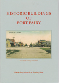
Booklet, Port Fairy Historical Society, Historic Buildings of Port Fairy, 2012
... This booklet is useful for those seeking quick information on the historic buildings in Port Fairy and for those wanting to undertake a walk around the town’s historic spots. ...Port Fairy, a small town in Western Victoria established in 1836, has an exceptional collection of public buildings and dwellings dating from the 1840s. This booklet gives short descriptions of 58 of these historic buildings, many with accompanying photographs. These include many buildings in Gipps and Sackville Streets, the Powder Magazine, some hotels, the Drill Hall, Dublin House, the Port Fairy Cemetery and several schools and churches. This booklet is useful for those seeking quick information on the historic buildings in Port Fairy and for those wanting to undertake a walk around the town’s historic spots. TryBooking will show you the full breakdown on the Booking Payment Report and the Event Revenue Itemised Report so you can clearly see the ticket sales, credit card processing fee and the funds that are yours. Front cover: ‘Historic Buildings of Port Fairy, Port Fairy Historical Society Inc.’ Photograph on front cover: ‘Sackville Str. Port Fairy’, ‘Sackville St. looking south 1910’ Back cover map: ‘Port Fairy Historic Buildings’ warrnambool, port fairy, western victoria, historic buildings -
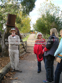
 Eltham District Historical Society Inc
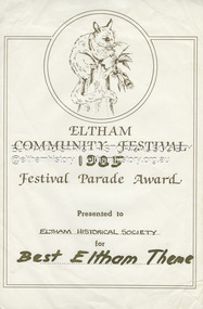
Document - Award Certificate, Eltham Community Festival, Festival Parade Award Presented to Eltham Historical Society for Best Eltham Theme, 1985
... General historic theme As per previous years, the Society participated in the Festival Parade with a float to ride on or walk beside. ...General historic theme As per previous years, the Society participated in the Festival Parade with a float to ride on or walk beside. ...1985: 8-10 November. General historic theme As per previous years, the Society participated in the Festival Parade with a float to ride on or walk beside. Members of the Victorian Folk Music Club again accompanied us. The Parade started at 12 noon, members assembling prior in Cecil Street at about 11.30 dressed in appropriate period costume.award, eltham community festival, eltham festival, festival parade award, grand parade, shire of eltham historical society, 1985 -
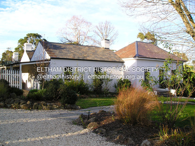
 Eltham District Historical Society Inc
Photograph, Fay Bridge, EDHS Heritage Excursion, Edendale Farm, 5 May 2018
... The historic homestead has undergone a significant restoration and there is on-going development of the site consistent with its community education purpose. The house and the gateway sculpture “The Fences Act” are covered by a Heritage Overlay in the Nillumbik Planning Scheme. Our May excursion will comprise a walk...The historic homestead has undergone a significant restoration and there is on-going development of the site consistent with its community education purpose. The house and the gateway sculpture “The Fences Act” are covered by a Heritage Overlay in the Nillumbik Planning Scheme. Our May excursion will comprise a walk ...May Excursion – Edendale Environs Edendale Community Environment Farm in Gastons Road, Eltham now operates as Nillumbik Council’s environmental centre. The historic homestead has undergone a significant restoration and there is on-going development of the site consistent with its community education purpose. The house and the gateway sculpture “The Fences Act” are covered by a Heritage Overlay in the Nillumbik Planning Scheme. Our May excursion will comprise a walk through the farm property and will radiate to other nearby places of historic interest. These will include the site of the Eltham North Adventure Playground to discuss its history and destruction by fire (see page 1 article). Also nearby is Colemans Corner where the early road system has undergone some unusual changes. If time permits we may visit some other nearby places of interest. - EDHS Newsletter No. 239 April 2018fay bridge collection, 2018-05-05, edendale community farm, edendale farm, eltham district historical society, heritage excursion, activities -
 Eltham District Historical Society Inc
Photograph, Fay Bridge, Rosehill Homestead, EDHS Heritage Excursion, 6 July 2019
... The walk also includes parts of the historic Cleveland Estate and the homestead “Rosehill” established by pioneer farmer Henry Stooke. ...The walk also includes parts of the historic Cleveland Estate and the homestead “Rosehill” established by pioneer farmer Henry Stooke. ...July Excursion July 6, 2019 - Exploring Lower Plenty The predominant feature of this walk in the Bonds Road area, Lower Plenty is the large number of magnificent old River Red Gums that line the route. These trees are of the spreading woodland form of this species indicating that they must have been originally growing in a reasonably open setting. The walk also includes parts of the historic Cleveland Estate and the homestead “Rosehill” established by pioneer farmer Henry Stooke. This area was the site of the first recorded European settlement in what was to become the Shire of Eltham when the Willis brothers arrived in the late 1830s. From the southern part of Cleveland Avenue there are extensive views across and along the Yarra Valley. An article on the history of this area was contained in Newsletter edition 201, November 2011. The walk will start at the at the corner of Bonds and Stawell Roads, Lower Plenty - EDHS Newsletter No. 246 June 2019fay bridge collection, 2019-07-06, blackburn bricks, eltham district historical society, heritage excursion, rosehill homestead, lower plenty -
Glen Eira Historical Society
Article - Rosstown Railway
... Concluding with information on the location of the Trail and the expected time required to walk the entire track included in the review is a map of the Rail Trail, which marks significant sites along the trail with historic pictures. 2/A newspaper article from THE AGE, dated Tuesday 21/10/1980 and written by Iola Matthews, reporting on the circumstances that led to the publication of the book RETURN TO ROSSTOWN written by Des Jowett and Ian Weickhardt. ...Concluding with information on the location of the Trail and the expected time required to walk the entire track included in the review is a map of the Rail Trail, which marks significant sites along the trail with historic pictures. 2/A newspaper article from THE AGE, dated Tuesday 21/10/1980 and written by Iola Matthews, reporting on the circumstances that led to the publication of the book RETURN TO ROSSTOWN written by Des Jowett and Ian Weickhardt. ...This file contains three items: 1/A review of the ROSSTOWN RAIL TRAIL from LIVING IN GLEN EIRA, vol. 11, 2004, Issue 4, no. 25, date and author unknown. The review explains the purpose of the Rail Trail with a brief narrative of the history behind Rosstown Sugar Mill Railway line. Concluding with information on the location of the Trail and the expected time required to walk the entire track included in the review is a map of the Rail Trail, which marks significant sites along the trail with historic pictures. 2/A newspaper article from THE AGE, dated Tuesday 21/10/1980 and written by Iola Matthews, reporting on the circumstances that led to the publication of the book RETURN TO ROSSTOWN written by Des Jowett and Ian Weickhardt. The article begins with a brief biography of the authors before moving into details of the book’s content, providing a further biography of W. Murray Ross which includes information on his financial ventures – particularly the Rosstown Rail – his marriage and children. The article includes a black and white photograph of Weickhardt and Jowett walking along the route of the railway line, an illustration of the Rosstown sugar works and a map of the area surrounding the site of the mill. 3/Three photocopies of a black and white illustration of the Rosstown sugar works from the east, undated and artist unknown.rosstown rail trail, rosstown, ross william, ross w. murray, ross murray, sugar beet mills, mills, elsternwick, land transport, railways, railway lines, railway routes, carnegie neville street, carnegie miller street, factories, market gardens, horticulture, peat, soils, land forms, topography, geology, civic issues, cone sugar industry, elsternwick plaza, elsternwick, glenhuntly road, parks and reserves, ee gunn reserve, caulfield racecourse, sportsgrounds, caulfield, carnegie, riddell parade, clarence street, aileen avenue, princes park, dover street, marara road, oakleigh road, rosanna street, murrumbeena crescent, north road, kooyong road, hawthorn road, booran road, koornang road, poath road, warragul road, railway platforms, railway buildings, bambra road, swamps, landforms, landfill, council landfill, railway bridges, bridges, railway underpasses, sporting clubs, tennis clubs, bowls clubs, rosstown railway, rosanna street reserve, maps, railway maps, living in glen eira, weickhardt ian, jowett des, caulfield south, curraweena road, oakleigh, caulfield technical school, return to rosstown, beet sugar industry, crops, land booms, land development and subdivisions, bent thomas, fink benjamin, sugar works, rosstown hotel, oamdenong road, rosstown dry cleaners, shops, rosstown road, rosstown plate, people by circumstance, migrants, accountants, occupations, professionals, the grange, real estate, grange road, financial agents, judges, rosstown estate, financial trouble, rabbit preserving, breweries, political debates, political issues, political electorates, politics, political science, debt, financial loans, court procedures, court cases, legal events and activities, malleson and riggall, widowers, seabeach railway, economics, economic deadline, depression 1890s, economic crash, mortgages, divorce, social problems, poverty, ross claude, ross roderick, world war 1914-1918, wars, military history, servicemen, australian flying corps, engineers, caulfield council, swagmen, homelessness, glenhuntly road, glenhuntly road tram, woornack road, leila road, wild cherry road, melten avenue, illustrations, steam trains, trains, horse and cart, horse-drawn transport, railway stations -
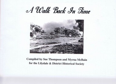 Greensborough Historical Society
Booklet, Sue Thompson et al, A walk back in time, 1990s
... Greensborough Historical Society 34A Glenauburn Road Lower Plenty Lower Plenty melbourne A compilation of 38 historic places in the Lilydale district. historic buildings pioneer walks Lilydale (Vic.) Photos and text from a self-guided walk around Lilydale. 43 p., illus., map. ...Photos and text from a self-guided walk around Lilydale.43 p., illus., map.non-fictionPhotos and text from a self-guided walk around Lilydale.historic buildings, pioneer walks, lilydale (vic.) -
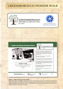 Greensborough Historical Society
Booklet, Greensborough Historical Society Inc, Greensborough Pioneer Walk, 2021
... Greensborough Historical Society 34A Glenauburn Road Lower Plenty Lower Plenty melbourne A guide to the historic photographs which have been mounted on 12 plaques in Greensborough Town Centre. greensborough pioneer walks greensborough historical society 8 p., photographs, captions and map Greensborough Pioneer Walk Booklet Booklet Greensborough Historical Society Inc. ...A guide to the historic photographs which have been mounted on 12 plaques in Greensborough Town Centre. 8 p., photographs, captions and mapgreensborough, pioneer walks, greensborough historical society -
Port Melbourne Historical & Preservation Society
Pamphlet - Historic Housing Schemes of Garden City 1994, Pat Grainger, Walks around Vintage Port No.5, Nov 1995
... Port Melbourne Historical and Preservation Society publication, "Walks around Vintage Port", No.5 Historic Housing Schemes of Garden City 1994 Edition...Garden City Built Environment City Engineers G B LEITH Fred COOK Port Melbourne Historical and Preservation Society publication, "Walks around Vintage Port", No.5 Historic Housing Schemes of Garden City 1994 Edition Walks around Vintage Port No.5 Pamphlet Historic Housing Schemes of Garden City 1994 Pat Grainger Port Melbourne Historical and Preservation Society (PMHPS) Snap Printing ...Tourism pamphlet produced in time for the visit of the Replica Endeavour to Station Pier, Nov/Dec 1994.Port Melbourne Historical and Preservation Society publication, "Walks around Vintage Port", No.5 Historic Housing Schemes of Garden City 1994 Editiongarden city, built environment, city engineers, g b leith, fred cook