Showing 72 items matching "horne street"
-
 Sunbury Family History and Heritage Society Inc.
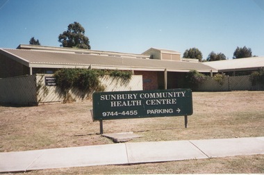
Photograph, Elwyn Davis, Former Sunbury Community Health Centre, March 2002
... ...Horne Street...The first Sunbury Community Health Centre was built on the corner of Horne Street and Gap Road in a temporary building. ...Cnr. Horne Street and Gap Road, Sunbury, Victoria, Australia...The first Sunbury Community Health Centre was built on the corner of Horne Street and Gap Road in a temporary building. ...The first Sunbury Community Health Centre was built on the corner of Horne Street and Gap Road in a temporary building. As result of further funding in 1974, a permanent building was erected and opened in 1981 and operated from that site until 2000 when it was relocated into a larger and more modern building on the former Sunbury Primary School site in Macedon Street to accommodate Sunbury's expanding population and needs.It now operates under the name of Sunbury and Cobaw Community Health Centre. The old building was demolished and replaced with a fast-food outlet.A non-digital coloured photograph of the Sunbury Community Health Centre showing the notice board displayed in the front giving phone details and parking area.sunbury community health centre, health centres, gap road, horne street -
 Glen Eira Historical Society
Article - BROTHELS
... ... Horne Street...Horne Street, Elsternwick, Victoria, Australia...Elsternwick Daily Planet Brothels Small Chris Estate Agents Horne Street Swimming pool Laundries Ross David ‘Bordello’ Metropolis City –Promotions Pty Ltd Eros Foundation Adult Entertainment Industry Association Article BROTHELS ...This file contains 3 items: 1/Newspaper article from The Age, 28/03/1990, asking for tenders for the business and freehold of the Daily Planet in Horne St Elsternwick. 2/Photocopied article from Herald Sun 18/09/1991, detailing some of the incentive schemes on offer for staff at the Daily Planet. Includes photograph of pool. 3/Article and photograph, The Age 12/09/1993 on Daily Planet open day for the general public.elsternwick, daily planet, brothels, small chris, estate agents, horne street, swimming pool, laundries, ross david, ‘bordello’, metropolis city –promotions pty ltd, eros foundation, adult entertainment industry association -
 Glen Eira Historical Society
Photograph - Beddoe Family & Store
... ... Horne Street...Corner Glen Huntly Road and Horne Street, Elsternwick, Victoria, Australia...Photograph taken 18/04/1916 All photos have unattributed, undated notes on reverse Beddoe Robert Henry Beddoe Ella Mary Beddoe Charles Crichton Beddoe Tysae Beddoe Archibald Beddoe FG Merchants Wood carters Glenhuntly road Elsternwick Wall Geo Photographers Beddoe wood yard Horne Street Carriers Coles store Young Charles Beddoe Francis George Photograph Beddoe Family & Store ...Three black & white photos of: Robert Henry Beddoe & family RH&FG Beddoe business premises and Beddoe wood yard on corner Horne St & Glenhuntly Rd Elsternwick. Photograph taken 18/04/1916 All photos have unattributed, undated notes on reversebeddoe robert henry, beddoe ella mary, beddoe charles crichton, beddoe tysae, beddoe archibald, beddoe fg, merchants, wood carters, glenhuntly road, elsternwick, wall geo, photographers, beddoe wood yard, horne street, carriers, coles store, young charles, beddoe francis george -
 Sunbury Family History and Heritage Society Inc.
Photograph, 13 April 2000
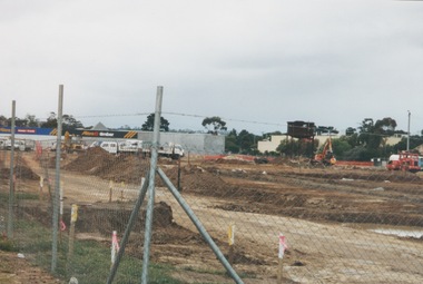
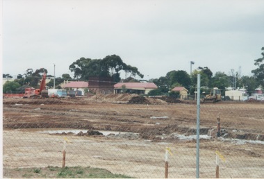
... ...Horne Street...Horne Street, Sunbury, Victoria, Australia...Sunbury railway station Horne Street A non-digital coloured photograph of a fenced off area undergoing development with earthmoving equipment and trucks in operation and some commercial buildings visible in the middle distance. ...In 2000 work commenced on the further development of railway land on the west side of Sunbury station for the construction of commercial and entertainment facilities. Prior to this time the land had been undeveloped and was often used to accommodate visiting circus troupes. Cereal storage silos also occupied this area for some time. The development of this area has been a reflection of the rapid expansion of settlement within Sunbury and surrounding areas that occurred during the latter years of the twentieth century.A non-digital coloured photograph of a fenced off area undergoing development with earthmoving equipment and trucks in operation and some commercial buildings visible in the middle distance.sunbury railway station, horne street -
 Sunbury Family History and Heritage Society Inc.
Photograph, c1999
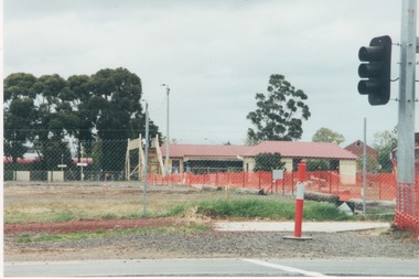
... The open area in the foreground was part of railway land on the west side of Sunbury Station along Horne Street. The initial preparations to develop the area into a commercial and entertainment precinct were just commencing. ...Horne Street, Sunbury, Victoria, Australia...Sunbury Global Learning Centre Macedon Street Sunbury melbourne The open area in the foreground was part of railway land on the west side of Sunbury Station along Horne Street. The initial preparations to develop the area into a commercial and entertainment precinct were just commencing. ...The open area in the foreground was part of railway land on the west side of Sunbury Station along Horne Street. The initial preparations to develop the area into a commercial and entertainment precinct were just commencing. The development that took place on this site was indicative of the growth that was taking place in Sunbury in the early 2000sA non-digital coloured photograph of an open area fenced off with temporary netting in preparation for construction work. A set of traffic lights are on the RHS of the photograph and a building is in the middle distance.sunbury railway station -
 Hume City Civic Collection
Photograph, Early 1980's
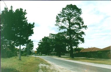
... ...horne street...A coloured photograph of Cornish Street, looking west taken from Horne Street, with an avenue of pine trees on either side of the road. ...Hume City Civic Collection 44 Macedon Street Sunbury melbourne cornish street horne street mt. holden george evans collection A coloured photograph of Cornish Street, looking west taken from Horne Street, with an avenue of pine trees on either side of the road. ...A coloured photograph of Cornish Street, looking west taken from Horne Street, with an avenue of pine trees on either side of the road. There is a roundabout at the first intersection and Mt. Holden can be seen in the distance.cornish street, horne street, mt. holden, george evans collection -
 Hume City Civic Collection
Photograph, Early 1990's
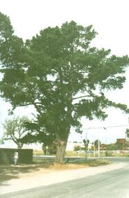
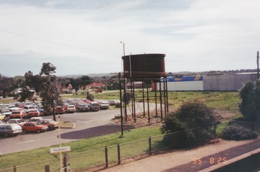
... ...horne street...A coloured photograph showing part of the T intersection at Cornish and Horne Streets. A large pine tree is growing at the corner immediately in front of a pedestrian crossing. ...The open land on the west side of the line was used by rail communters as a car park. cornish street horne street water towers coles supermarket sunbury railway station george evans collection A coloured photograph showing part of the T intersection at Cornish and Horne Streets. ...The photograph was taken after Coles Supermarket and Sunbury Shopping Square were constructed on the railway land on the east side of the line in 1989, but before the Safeway-Woolworths complex was built in 2000 on the west side of the railway line. The open land on the west side of the line was used by rail communters as a car park.A coloured photograph showing part of the T intersection at Cornish and Horne Streets. A large pine tree is growing at the corner immediately in front of a pedestrian crossing. The railway car park, metal water tower and Coles Supermarket are in the background. A boy is walking along the footpath.cornish street, horne street, water towers, coles supermarket, sunbury railway station, george evans collection -
 Sunbury Family History and Heritage Society Inc.
Photograph, Marilyn Bray, 5th November 2000
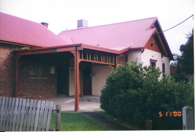
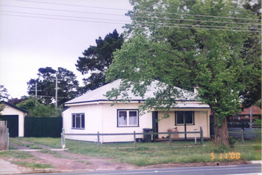
... ...Horne Street...Over the years, this building, at the corner of Neill and Horne Streets, has had a number of uses. The original weatherboard structure was a farmhouse before the surrounding farmland was subdivided. ...Over the years, this building, at the corner of Neill and Horne Streets, has had a number of uses. The original weatherboard structure was a farmhouse before the surrounding farmland was subdivided. ...Over the years, this building, at the corner of Neill and Horne Streets, has had a number of uses. The original weatherboard structure was a farmhouse before the surrounding farmland was subdivided. It then became a private house. In the 1990s the brick section was added and the building was an x- ray centre. Some time after 2010 it was demolished, along with a number of other adjacent cottages in Horne Street, to make way for a drive-in commercial centre.A non-digital coloured photograph of a partial view of a sizeable house that has been built in stages with the remains of an unpainted wooden picket fence in the front and low growing shrubs in the garden. One section of the building is a brick structure with a pitched red corrugated iron/colourbond roof and the second section is built from cream painted weatherboards. A metal porch connects the two sections and a low ramp leads to the front door.neill street, horne street, housing, medical centres, sunbury -
 Sunbury Family History and Heritage Society Inc.
Photograph, Rosa McCall, 2000
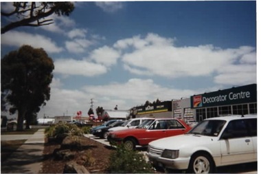
... Horne Street...The commercial development was built along Horne Street between Mitchells Lane and Neill Street in 2000 on land that had been open space. ...The commercial development was built along Horne Street between Mitchells Lane and Neill Street in 2000 on land that had been open space. ...The commercial development was built along Horne Street between Mitchells Lane and Neill Street in 2000 on land that had been open space. This development was one of many that reflected the growth of Sunbury from a country town to an outer suburb of Melbourne.A non-digital coloured photograph of a commercial centre with cars parked in the designated area in front of the businesses. Along the roadside and bordering the footpath are large gum trees. horne street, neill street, mitchells lane, pasley street, sunbury, commercial development -
 Sunbury Family History and Heritage Society Inc.
Photograph, Rosa McCall, 2001
... ...Horne Street...The photograph was taken looking towards Jacksons Hill at the T intersection of Mitchells Lane and when Vineyard Road becomes Horne Street, before there was a lot of commercial development at that intersection and on Jacksons Hill....Jacksons Hill Mitchells Lane Vineyard Road. Horne Street Sunbury A coloured photograph of an intersection where a small car is waiting to go ahead. ...The photograph was taken looking towards Jacksons Hill at the T intersection of Mitchells Lane and when Vineyard Road becomes Horne Street, before there was a lot of commercial development at that intersection and on Jacksons Hill.A coloured photograph of an intersection where a small car is waiting to go ahead. Some cars are parked in an allotment outside building on the opposite side of the road.jacksons hill, mitchells lane, vineyard road., horne street, sunbury -
 Sunbury Family History and Heritage Society Inc.
Photograph, Marilyn Bray, 5th November 2000
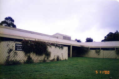
... ...Horne Street...The Horne Street building was sold to developers and a fast-food outlet now occupies the site....The Horne Street building was sold to developers and a fast-food outlet now occupies the site. ...The Shire of Bulla received a grant of $88,000 from the Federal Government on 14th March 1974. A public meeting was called to discuss how the funds would be used. After much discussion it was decided to establish a Community Health Centre for Sunbury and surrounding areas. In 1975, a new building opened on the corner of Gap Road and Horne Street. In 2000 as the health needs of the area increased the Community Health Centre relocated to a more modern building on the former Sunbury Primary School site in Macedon Street. The Horne Street building was sold to developers and a fast-food outlet now occupies the site.Over the years the Sunbury Community Health Centre has provided many important health related services for the community.A non-digital coloured photograph of an L shaped building with a low pitched roof and a trellis covering the front view of the building. A notice board attached to the trellis gives the details of a podiatry practice.sunbury community health centre, sunbury cobaw health centre, health centres, horne street, gap road, sunbury -
 Sunbury Family History and Heritage Society Inc.
Photograph, Marilyn Bray, 5th November 2000
... Horne Street...This is one of a number of cottages that were in Horne Street, Sunbury and have been demolished to make way for commercial development. ...This is one of a number of cottages that were in Horne Street, Sunbury and have been demolished to make way for commercial development. ...This is one of a number of cottages that were in Horne Street, Sunbury and have been demolished to make way for commercial development. It was built at no.30 at the corner of Horne and Cornish Streets some time in the 1930s. Originally it was a house for railway employees working at Sunbury. In later years it was a private house. It was demolished in the early 2010s. A car wash facility now stands on the site.A non-digital coloured photograph of a double fronted fibrocement house with a corrugated iron roof and navy blue trim around the sash windows and the guttering. A partial view of a garage is on the LHS and a large elm tree is growing on the front nature strip.horne street, cornish street, sunbury, railway houses -
 Sunbury Family History and Heritage Society Inc.
Photograph, Marilyn Bray, 5th November 2000
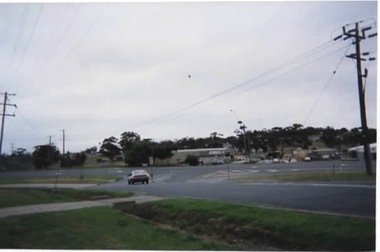
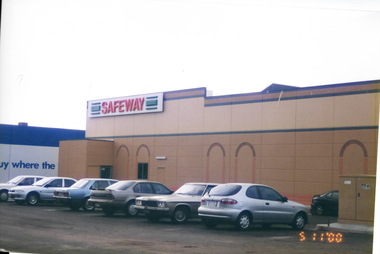
... ...Horne Street...In the early 1990s, open land which was situated on the west side of Sunbury Railway Station and fronting on to Horne Street, underwent development with Big W and Safeway stores, a theatre complex, car park and other businesses built on the site....In the early 1990s, open land which was situated on the west side of Sunbury Railway Station and fronting on to Horne Street, underwent development with Big W and Safeway stores, a theatre complex, car park and other businesses built on the site. ...In the early 1990s, open land which was situated on the west side of Sunbury Railway Station and fronting on to Horne Street, underwent development with Big W and Safeway stores, a theatre complex, car park and other businesses built on the site.For many years the open land on the west side of Sunbury Railway Station was the venue for travelling circus groups. A wheat silo, which local cereal crop farmers used to store their wheat, occupied some of the land.A non-digital coloured photograph of the rear view of a Safeway store and 7 cars in the adjoining carpark.sunbury railway station, commercial development, horne street, sunbury -
 Sunbury Family History and Heritage Society Inc.
Photograph, 25th
... ...horne street...The photograph of Sunbury was taken from the pedestrian bridge at the railway station and is looking NW to Horne Street and beyond. The water tower in the foreground was used to pump water into the steam train engines. ...Sunbury Sunbury railway station horne street A non - digital coloured photograph of an elevated view of Sunbury with a metal water tower in the foreground and a car park with commercial buildings in the middle distance. ...The photograph of Sunbury was taken from the pedestrian bridge at the railway station and is looking NW to Horne Street and beyond. The water tower in the foreground was used to pump water into the steam train engines. The commercial development on the site was built shortly before this photograph was taken.A non - digital coloured photograph of an elevated view of Sunbury with a metal water tower in the foreground and a car park with commercial buildings in the middle distance.sunbury, sunbury railway station, horne street -
 Sunbury Family History and Heritage Society Inc.
Photograph
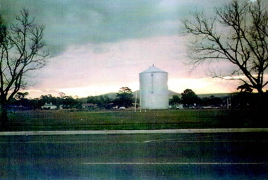
... ...Horne Street...The photograph was taken in Evans Street looking across to Horne Street and the hill in the distance is Mount Holden. ...The photograph was taken in Evans Street looking across to Horne Street and the hill in the distance is Mount Holden. ...For a few years a wheat silo was erected on railway land on the west side of the Sunbury line. The photograph was taken in Evans Street looking across to Horne Street and the hill in the distance is Mount Holden. Just beyond the two elm trees was the former sports ground, that was used before the Clarke Oval was built. Local farmers used the silo to store their grain before it was transported to other destinations either by rail or road. The silo was dismantled in the 1980s to make way for commercial development on the site. Cereal growing was one of the agricultural pursuits practised in the area around Sunbury until the land was sold and developed for housing. A scanned coloured photograph of a wheat silo erected in an open area with some cottages and a bare hillside visible in the background. Two bare elm trees are in the foreground.wheat silos, sunbury railway line, horne street, evans street -
Hume City Civic Collection
Photograph, Joyce Jones, 30th May 1995
... Horne Street, Sunbury, Victoria, Australia ...Joyce Jones is the lady in the photograph, who was a resident of the Westmeadows Caravan Park. While being photographed she made the following statements about her life - "I own my caravan, I'm independent." Other of her quotes included " A tit for tat, a deener in your pocket and a bit of dodger and you're not doing too badly."This image is one of a collection of photographs of elderly residents within the former Shire of Bulla who used to attend a regular social function run by the Sunbury Community Health Centre.A sepia photograph of a lady seated at a table in a caravan.sunbury community health centre, shire of bulla, joyce jones -
 Sunbury Family History and Heritage Society Inc.
Photograph, 2000
... Horne Street, Sunbury, Victoria, Australia ...Excavation work began to remove the grasslands and trees on the railway land on the west side of the Sunbury Station to make way for commercial development on that side of the line.A non-digital coloured photograph of excavation work in operation on land which has cyclone fencing around its perimeter. There are buildings in the middle distance beyond the work site.sunbury railway station -
Glen Eira Historical Society
Document - Wallace, John Alston
... ... Horne Street...Wallace Theresa Wallace Mrs Monahan Theresa Quat Quatta Glenhuntly Road Staniland Grove Elsternwick Gold Mining Mines and Mining House Names Mansions Members of Parliament Selwyn Street Horne Street Dickens Street Officials Millar. M Pugh Alfred Glen Eira Road Architectural Features Caulfield Rate Books Davies J.H. ...This file contains four items. Short hand-written notes on Hon. J. Alsten Wallace’s business activities, including a note on his marriage to the second daughter of Thomas Monahan taken from Cooper’s St Kilda Typed notes with hand-written annotations on QUAT QUATTA, the house bought by John Alston Wallace c. 1875-6. The document details the interior and exterior of the house, and mentions renovations and its use for wedding receptions. Also noted is information on Wallace’s place of birth, migration, marriage, number of children and the date of his wife’s death, taken from the Australian Representative Men Vol. 1. A hand-written list of John Alston Wallace’s properties, author and date unknown Hand-written listing and directory notes regarding John Alston Wallace’s properties, taken from MEMOIRS OF A STOCKMAN by Harry Peck. Date and author unknown.wallace john alston, wallace john, wallace j. alston, wallace j.a., wallace theresa, wallace mrs, monahan theresa, quat quatta, glenhuntly road, staniland grove, elsternwick, gold mining, mines and mining, house names, mansions, members of parliament, selwyn street, horne street, dickens street, officials, millar. m, pugh alfred, glen eira road, architectural features, caulfield rate books, davies j.h., riddell mrs c., lawford c.c., young geo, pasco crawford, elsternwick railway station -
Glen Eira Historical Society
Document - Reeves, Walter
... ... Horne Street...Automobile Hebenstreit Mr Shoobra Road Butcher Glenhuntly Road Henderson H Mr Davis Charles Hardware store Beddoe Frank Horne Street Shops Renown Theatre Phoebe Theatre Theatres LePage Phoebe LePage Jack Taylor ‘Squizzie’ Echuca Terrace Edward Street Hawthorn Road Revees Walter Dunn Bros Cycle shop Cox Bros Supermarkets Apps (Undertakers) Elsternwick Men’s Club Elsternwick Trades Club Johnston T. ...2 items, which may be related, about old Elsternwick: 1/A roneod copy of Recollections of Walter Reeves: gives notes on local identities, their business’, Caulfield State School, places of interest and events that took place in the area; undated and apparently summarised by an un-named other person from Mr Reeves' recollections. 2/A hand written list taken from Rate Books 1864 of areas in dispute, including nine names of residents, between Caulfield and St Kilda, date and author unknown. No direct connection to Walter Reeves apparent but they are taped together.automobile, hebenstreit mr, shoobra road, butcher, glenhuntly road, henderson h mr, davis charles, hardware store, beddoe frank, horne street, shops, renown theatre, phoebe theatre, theatres, lepage phoebe, lepage jack, taylor ‘squizzie’, echuca terrace, edward street, hawthorn road, revees walter, dunn bros, cycle shop, cox bros, supermarkets, apps (undertakers), elsternwick men’s club, elsternwick trades club, johnston t., hayter george (painter and decorator), sargood frederick, cabmen, cabs, ‘ripponlea’, wilson dick, blacksmiths, orrong road, moran and cato, repco, downshire road, bullock (grocer), grocers, taylor’s liquor and wine saloon, bottleshops, biddle misses, schools, bliss mr, station master, elsternwick, bensonino mr, newsagents, caulfield, gas supply, point nepean road, rowney dick, trams, riddell’s paddock, football golf links, riddell john carre, rowan road, sports grounds, melville’s supermarket -
Glen Eira Historical Society
Article - McMillan Street, 14, Elsternwick
... ... Horne Street...Point Nepean Road Horne Street Jones Ernest Agg Cyril Noel Anthony Sherbrooke Flats Article McMillan Street, 14, Elsternwick ...Two items in this file. Three real estate advertisements in The Leader Newspaper dated 07/09/2002, 04/11/2000 and 14/07/2003 for flats 27, 21, and 19. Additional research by Joan Moore 09/10/2012 from Sands and McDougall’s Directories on property previously called Sherbrooke.sherbrooke, house names, apartments, mcmillan street, elsternwick, bell j. mrs., point nepean road, horne street, jones ernest, agg cyril, noel anthony, sherbrooke flats -
Glen Eira Historical Society
Plan - Nettalie
... ... Horne Street...Caulfield Caulfield North Elsternwick St Kilda East Parish of Prahran Parish of Moorabbin Caulfield Road District Melbourne and Brighton Railway Rosstown Railway Elsternwick Railway Station Caulfield Railway Station Rosstown Railway Station Murrumbeena Railway Station Baptist Church Paddy’s Swamp reserve Cemetery Reserve Leman Swamp Reserve Caulfield Racecourse Reserve Brighton Cemetery The Vine Caulfield Hotel The Tam O’Shanter Hotel Melbourne Hunt Hotel Royal Hotel Hotham Street Horne Street Nepean Highway North Road Orrong Road Dandenong Road Princes Highway Kooyong Road Alma Road Inkerman Road Balaclava Road Glen Eira Road Glen Huntly Road Hawthorn Road Cemetery Road Bambra Road Redan Road Kambrook Road Neerim Road Booran Road Racecourse Road Grange Road Koornang Road Murrumbeena Road Crosbie Road Kangaroo Road Poath Road Ford W Lempriere Cople J Riddell J C Manifold J Testar T Billing R H Semple Blundell Shaw A Butchart G Stephen J W Stephen G Sir Hart J Duncan G Blackie R Stephen F McCombie T Woollaston H Higgins J Lloyd J C Daish J McLeod J Hughes D Wilson A Jamieson G Webb G H Renwick S Pennington H Dunn J Kirkpatrick W Ricketson W Toad A Sayce J Watts T Widgery Store Guess J Anketell J Clack J Sissen W Clayton G Dickson D Bevan J Hart T Anderson J Hart Mrs Webb H Masters S Waghorn J Hemming C Hiam C Farquhar W Newing T Payne T Cooper R Snipe S Chambers J Forster W Summers R Harriman B Warrick O’Connell Long J Peck R Cochrane C Murray Ross W Evans C Kennedy J Maclean N Forster Lyall W Dean J Newton H Looker W Baker C Johnston Crosbie J Kerr Jones Parr Nelson C Montgomery L Parsons W James J C Sibon C Smith Sydney W Plans Maps Land subdivisions Land use Settlements Roads and streets Hotels Churches Police stations Post offices Land surveys Railway stations Railways Schoolhouses Commerce Clergy residences Official buildings Local government Road districts Plan Nettalie ...An A4 photocopy of the 'Plan of the Caulfield Road District' dated 1867. This plan shows the location of the properties owned by A Shaw and Blundell on Balaclava and Orrong Roads where Nettalie is situated. The plan includes all the landowners listed where their property was, the street names and other landmarks of 1867 including railways, hotels and reserves.caulfield, caulfield north, elsternwick, st kilda east, parish of prahran, parish of moorabbin, caulfield road district, melbourne and brighton railway, rosstown railway, elsternwick railway station, caulfield railway station, rosstown railway station, murrumbeena railway station, baptist church, paddy’s swamp reserve, cemetery reserve, leman swamp reserve, caulfield racecourse reserve, brighton cemetery, the vine caulfield hotel, the tam o’shanter hotel, melbourne hunt hotel, royal hotel, hotham street, horne street, nepean highway, north road, orrong road, dandenong road, princes highway, kooyong road, alma road, inkerman road, balaclava road, glen eira road, glen huntly road, hawthorn road, cemetery road, bambra road, redan road, kambrook road, neerim road, booran road, racecourse road, grange road, koornang road, murrumbeena road, crosbie road, kangaroo road, poath road, ford w, lempriere, cople j, riddell j c, manifold j, testar t, billing r h, semple, blundell, shaw a, butchart g, stephen j w, stephen g sir, hart j, duncan g, blackie r, stephen f, mccombie t, woollaston h, higgins j, lloyd j c, daish j, mcleod j, hughes d, wilson a, jamieson g, webb g h, renwick s, pennington h, dunn j, kirkpatrick w, ricketson w, toad a, sayce j, watts t, widgery, store, guess j, anketell j, clack j, sissen w, clayton g, dickson d, bevan j, hart t, anderson j, hart mrs, webb h, masters s, waghorn j, hemming c, hiam c, farquhar w, newing t, payne t, cooper r, snipe s, chambers j, forster w, summers r, harriman b, warrick, o’connell, long j, peck r, cochrane c, murray ross w, evans c, kennedy j, maclean n, forster, lyall w, dean j, newton h, looker w, baker c, johnston, crosbie j, kerr, jones, parr, nelson c, montgomery l, parsons w, james j c, sibon c, smith sydney w, plans, maps, land subdivisions, land use, settlements, roads and streets, hotels, churches, police stations, post offices, land surveys, railway stations, railways, schoolhouses, commerce, clergy residences, official buildings, local government, road districts -
 Sunbury Family History and Heritage Society Inc.
Photograph, 17 December 1985
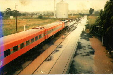
... ...horne street...The photograph is looking to the north of the station and takes in the historic Macedon Street bridge and the open ground with the storage silo on the west side of the railway line. sunbury railway station storage silos horne street A non-digital coloured photograph of a former V Line train stopped at a station where the railway line has been flooded. ...On 17th December 1985 record torrential rain fell in Sunbury, which flooded the main Melbourne Bendigo rail line and disrupted traffic. The photograph is looking to the north of the station and takes in the historic Macedon Street bridge and the open ground with the storage silo on the west side of the railway line. A non-digital coloured photograph of a former V Line train stopped at a station where the railway line has been flooded. A storage silo occupies vacant ground adjacent to the railway line.sunbury railway station, storage silos, horne street -
 Sunbury Family History and Heritage Society Inc.
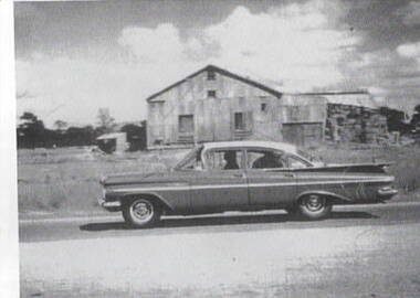
Photograph, Hay shed, c1960s
... ...Horne Street...Street. Retail shops including Harris Scarf now occupy the site. The pine trees in the background were along Horne Street.The hay was stored in this building before being transported....Hay Shed Railways Sunbury Station Evans Street Horne Street A scanned print of an old black and white photograph of a corrugated shed with hay bales stacked at the rear of the building. ...The hay shed was sited on railway land fronting onto Evans Street and near Station Street. Retail shops including Harris Scarf now occupy the site. The pine trees in the background were along Horne Street.The hay was stored in this building before being transported.Cereal growing was one of the agricultural activities carried out in the Sunbury area.A scanned print of an old black and white photograph of a corrugated shed with hay bales stacked at the rear of the building. A 1960s sedan car is parked in front of the building and there is a smaller shed in the background.hay shed, railways, sunbury station, evans street, horne street -
 Sunbury Family History and Heritage Society Inc.
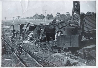
Photograph, Train crash
... The tree-lined street in the background is Horne Street....The tree-lined street in the background is Horne Street. Train crash Photograph ...The train crash pictured in the photograph occurred at Sunbury between the station and the Station Street level crossing on 6th February 1952 at around 10pm. The goods train, pulled by a green locomotive, ran into the back of another stationary goods train on the rail line. The guard, A.C Read, in the stationary goods train was killed. P. J. McWhirter, the guard in the other train was injured.Over the years there have been a number of train smashes in the vicinity of Sunbury Station. The rail service runs from the river town of Echuca and then on to Bendigo and Melbourne. Since its inception in 1861, a lot of rail traffic both passenger and freight has been transported along this rail line.A non-digital black and white photograph of a train accident involving a goods train with some of the carriages smashed and lying on their sides. A level crossing is a short distance from the crash and open land on either side of the rail tracks is in the distance. Nine men are working at the scene of the crash. The tree-lined street in the background is Horne Street.train smashes, goods freight, sunbury railway line, sunbury station -
 Hume City Civic Collection
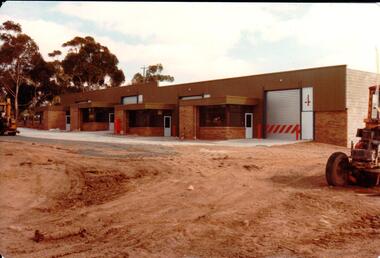
Photograph, 1/12/1982
... The railway land between Horne Street and the railway line was developed for commercial and industrial purposes during the late 1970s and early 1980s. ...Hume City Civic Collection 44 Macedon Street Sunbury melbourne The railway land between Horne Street and the railway line was developed for commercial and industrial purposes during the late 1970s and early 1980s. ...The railway land between Horne Street and the railway line was developed for commercial and industrial purposes during the late 1970s and early 1980s. The former Shire of Bulla developed much of this area and leased the space to private companies.A coloured photograph with rounded corners of 4 brick factory units. There is a large digger on the RHS. The area in front of the units has been paved but the remaining area is unsealed.factories, industrial estates, shire of bulla, george evans collection -
 Sunbury Family History and Heritage Society Inc.
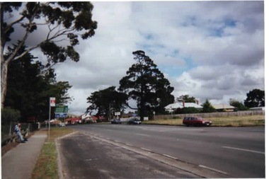
Photograph, Rosa McCall, Gap Road, Sunbury, 2000
... The photograph is of Gap Road just west of Horne Street in Sunbury. The open ground on the RHS is on the corner of Pasley Street and was taken before the adjoining blue stone cottage was demolished. ...The photograph is of Gap Road just west of Horne Street in Sunbury. The open ground on the RHS is on the corner of Pasley Street and was taken before the adjoining blue stone cottage was demolished. ...The photograph is of Gap Road just west of Horne Street in Sunbury. The open ground on the RHS is on the corner of Pasley Street and was taken before the adjoining blue stone cottage was demolished. In 2020 the cottage was demolished and a large medical centre, complete with car parking was built on the property.Gap Road is one of Sunbury's main roads and is the quickest route to take from the town to the Calder Highway and on to Bendigo.A non-digital coloured photograph of a main road with a bus stop in the foreground and some open ground on the RHS of the image. gap road, pasley street, medical centre, sunbury -
 Hume City Civic Collection
Photograph, Rail accident, 1952
... The tree lined street in the background is Horne Street....The tree lined street in the background is Horne Street. This smash was one of a number that have happened along the Sunbury rail line and in the vicinity of Sunbury Station over the years. ...The train smash occurred in Sunbury between the Station Street level rail crossing and Sunbury Station on February 6th 1952 at around 10pm. The goods train was being pulled by the green locomotive, which was used to take the Jubilee train throughout Victoria in 1951, to acknowledge 125 of European settlement in Victoria, ran into the back of another stationary goods train on the rail line. The guard, A.C Read, in the stationary goods train was killed. P J Mcwhirter, the guard in the other train was injured. The tree lined street in the background is Horne Street.This smash was one of a number that have happened along the Sunbury rail line and in the vicinity of Sunbury Station over the years.A black and white photograph with a white border of a train smash which wrecked a steam engine and carriages. Workmen are on the tracks surveying the wreckage. A rail crossing is in the background.jubilee train, train crashes, station street, sunbury railway station, a c read, p j mcwhirter -
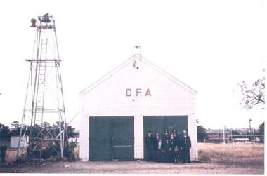 Hume City Civic Collection
Photograph, Early 1970s
... The butter factory in Horne Street is on the RHS and the former public tennis courts are on the LHS of the photograph....The butter factory in Horne Street is on the RHS and the former public tennis courts are on the LHS of the photograph. country fire authority fire fighters sunbury fire station butter factory tennis courts george evans collection A coloured photograph of the CFA firemen standing outside the former CFA building. ...The old Sunbury CFA station was situated in Evans Street where part of the Sunbury Shopping Square has been built. It was opened on that site in 1914. In 1969 a newer fire station was built in Evans Street on the opposite side of the road and closer to Macedon Street. From 1969 until 1978 the old fire station became a scout hall. In the early 2000s two new fire stations were built away from the main shopping area. One was built in Jackson Street, opposite the Ball Court Hotel and the other one was built on the corner of Gap Road and Elizabeth Drive. By locating them out of the immediate shopping centre which had become quite busy, it meant that access in and out of the new stations was quicker. The butter factory in Horne Street is on the RHS and the former public tennis courts are on the LHS of the photograph.A coloured photograph of the CFA firemen standing outside the former CFA building. The bell tower is on the LHS of the building.country fire authority, fire fighters, sunbury fire station, butter factory, tennis courts, george evans collection -
 Warrnambool and District Historical Society Inc.
Film - DVD, Newell Barrett, Tower Hill, W. H Barrett, 2012
... Warrnambool and District Historical Society Inc. 2 Gilles Street (south of Merri St) Warrnambool great-ocean-road William Horne Barrett was the great uncle of the donor and maker of the DVD, Newell Barrett. ...William Horne Barrett was the great uncle of the donor and maker of the DVD, Newell Barrett. The DVD contains photographs of Barrett’s enlistment and embarkation for England and the photographs are accompanied by a commentary and text. Sergeant William Barrett enlisted in the 39th Battalion, C Company in 1916, and, although he came from Ballarat, his name is on the Warrnambool War Memorial as a local enlistment. His mother was Mary Ann Horne and the Hornes were farmers in the Allansford/Nullawarre area. Barrett was killed in action in October 1917 at Broodseinde, Belgium. He was buried near the trench he was occupying and today has no known grave. This DVD is of some significance as it contains information on a World War One soldier who was connected to the Warrnambool area through his mother, a member of the Horne family who were farmers in the Allansford/Nullawarre area. It will be useful for researchers.This is a DVD-R disc of the enlistments and embarkation details of William Horne Barrett (World War One). The running time is 56 minutes. The cover has two photographs of the Canberra Australian War Memorial in muted colour and an inset photograph of William Barrett. Front Cover: ‘William Horne Barrett, died 4th October 1917, Battle of Broodseinde, Belgium, Visit to the War Memorial, May 23rd to 24th 2012, Part One, Enlistment to England’. world war one, horne family, william horne barrett -
 Warrnambool and District Historical Society Inc.
Document - Ledger, Cash Book, Circa 1917
... Warrnambool and District Historical Society Inc. 2 Gilles Street (south of Merri St) Warrnambool great-ocean-road This cash book contains entries relating to the farrier business of W M McCullough in Fairy St Warrnambool. It lists names and numbers of shoes replaced. It dates from January 1917 to march 1919 and contains many local names such as Sheldrick, Selby, Skuse, Horne ...This cash book contains entries relating to the farrier business of W M McCullough in Fairy St Warrnambool. It lists names and numbers of shoes replaced. It dates from January 1917 to march 1919 and contains many local names such as Sheldrick, Selby, Skuse, Horne and Saltau, to name a few.Listing many local people and being associated with a local business, it has social and historical significance. Green cloth covered card cover with maroon binding. Blue, maroon and white patterned inside covers. White paper label edged in floral design, pasted to front cover. 92 pages double numbered to page opening. Hand written entries to page 32 warrnambool farriers, w mccullough warrnambool, farriers of warrnambool, 1915 farriers