Showing 771 items matching "houses - kew - kew east"
-
 Kew Historical Society Inc
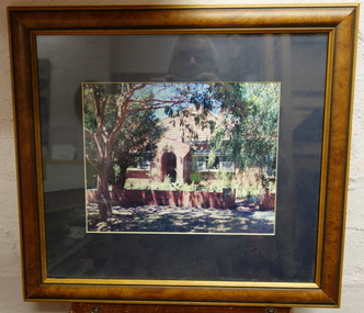
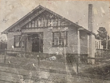
Photograph - Framed Photograph, Red Brick House
... houses - kew - kew east...Framed and glazed small photograph of a red brick house in Kew or Kew East...Kew Historical Society Inc Kew Court House 188 High Street Kew melbourne Unidentified house. KHS welcomes viewers to identify the location houses - kew - kew east Nil Framed and glazed small photograph of a red brick house in Kew or Kew East Red Brick House Photograph Framed Photograph ...Unidentified house. KHS welcomes viewers to identify the locationFramed and glazed small photograph of a red brick house in Kew or Kew EastNilhouses - kew - kew east -
 City of Melbourne Libraries
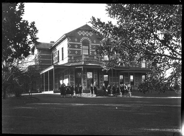
Photograph, Bull, Hugh Jones, 1897-1993, Ruyton Girls School 1933
... East Melbourne melbourne Published: Age (Melbourne, Vic.: 1854- ), 4 August 1933, page 3 Published title: GIRLS’ SCHOOLS – MODEL YACHTING - FOOTBALL Published caption: The headmistress, Miss H. Daniell, and girls at Ruyton, Selbourne Road, Kew, snapped after school hours. Trove article identifier: http://nla.gov.au/nla.news-article204381763 Research by Project Volunteer, Louise McKenzie: Rather than the people, this charming building takes the eye! Originally named “Tarring”, it was built in 1872 by Mr Henry Henty and his wife Mrs Marion Anne Henty (nee McKellar) for their family. Located at 82 Selbourne Road, Kew, it is described by Melbourne’s Open House ...Published: Age (Melbourne, Vic.: 1854- ), 4 August 1933, page 3 Published title: GIRLS’ SCHOOLS – MODEL YACHTING - FOOTBALL Published caption: The headmistress, Miss H. Daniell, and girls at Ruyton, Selbourne Road, Kew, snapped after school hours. Trove article identifier: http://nla.gov.au/nla.news-article204381763 Research by Project Volunteer, Louise McKenzie: Rather than the people, this charming building takes the eye! Originally named “Tarring”, it was built in 1872 by Mr Henry Henty and his wife Mrs Marion Anne Henty (nee McKellar) for their family. Located at 82 Selbourne Road, Kew, it is described by Melbourne’s Open House organisation as “… a two-storey, polychrome brick mansion built for them by prominent Melbourne architect Albert Purchas. The house and nearly four acres of grounds served as their family home until the death of Marian Henty in 1919. “ (See below for further information on Albert Purchas.) In 1920 it was sold to Ruyton Girls School. Ruyton was established in 1878 by its first principal, Charlotte Anderson (1838-1906), who named it in honour of the parish in Shropshire, England, Ruyton-XI-Towns, where her great-great-grandfather David Evans had been vicar. Its motto is Recte et Fideliter, meaning "Upright and Faithful", which is also the name of the school song. The original school, one of Victoria’s oldest independent schools for girls, was located at the home of Mrs Anderson at 63 High Street South, Kew. In 1882 she moved the school to Edgecombe in Studley Park Road. Mrs Anderson retired due to ill health and sold the school to her friend Miss Eliza Bromby. One of Ruyton's four Houses, Anderson, is named for Charlotte Anderson. When Ruyton Girls School was moved to the site in 1920 it established the building as a Boarding House, and renamed the building “Henty House” in honour of its original owners. Today the school remains an all girls’ school, and pays tribute to its founder and the historic significance of Henty House and its magnificent Moreton Bay Fig tree, which still stands today. The building retains many original, Victorian-era features, while also showing the layers of change, made over the decades in order to meet the evolving needs of one of Melbourne’s leading schools. The headmistress mentioned in the caption for MCK016 is Miss Hilda Daniell, shown standing in front of Henty House in the midst of a group of Ruyton girls in their school uniforms, some holding hockey sticks. Miss Daniell was the longest serving Principal of Ruyton 1913-1952. She was originally a student in 1893, then joined the teaching staff in 1898. It was under her leadership that the School purchased and moved to “Tarring”. The boarding house included a flat for Hilda to live onsite. An article in the Ruyton Heritage Collection – Bedford Series, dated 21 May 2021 cites that Miss Daniell “was affectionately known as “Dream” by Ruytonians of her era” apparently due to a tendency to quiet reflection. The article continues, “After her retirement in 1952 Miss Daniell was awarded an Order of the British Empire for her many services to education, an award she received from the hands of the Queen during the 1954 Royal Tour. Also in 1952, the Kew Council honoured her by renaming Brougham Place as ‘Daniell Place’.” Arthur Purchas, architect: The architect responsible for the design of “Tarring”. Arthur Purchas, was extremely active and highly regarded at this time. Born in Wales in 1825, he emigrated to Melbourne in 1851 and soon established a private practice as a surveyor and architect, with offices variously in Little Collins, Queen Street, Chancery Lane, and finally 462 Little Collins Street. Wikipedia notes in an early reference to Purchas that “An early story is that one of his first jobs, when he would have been about 25 years old, was a position under Surveyor-General Robert Hoddle, and disagreeing with him over the line for St Kilda Road, appealed to Governor La Trobe, and successfully got the road diverted around the hill which eventually became the site of the Shrine of Remembrance. There may not be much truth to this, since by 1851 St Kilda Road was already a well worn track running around the hill, the top of which La Trobe had reserved for a Government House in 1840.” The timing of Purchas’s arrival in Melbourne was perfect. The Victorian gold rush of the 1850’s generated enormous wealth in Melbourne, and a building boom followed. The Wikipedia entry continues … that alone, or with his brother in law Charles R Swyer, “Purchas is said to have designed over 140 houses, offices, churches, banks and cemetery buildings in Victoria in his long career. Berkely Hall, St Kilda dating from 1854 is one of his first buildings, and still exists, though the original house is obscured by an early C20th verandah. Another notable early design was the head office of the Melbourne Savings Bank, built on the corner Flinders Lane and Market Street in 1857-58, in an elaborately detailed Renaissance Revival style. His churches were mostly Gothic Revival, built for the Anglican Church, along with some parsonages, while most of the bank buildings were Renaissance Revival designs for the Bank of Australasia. He also designed city buildings in the 1860s and 70s, such as the Mutual Insurance Co, Northern Insurance Co, and the first premises for George & George, destroyed by fire in 1889. One of his most outstanding designs is St George's Presbyterian Church in Chapel Street, St Kilda (1877–80), in a striking polychrome brick Gothic Revival style, unusually carried on through to the interior. Purchas produced one of the few published maps and compilations of the early pastoral settlers runs in Victoria in 1853. In the same year he designed the layout of the Melbourne General Cemetery, the first 'garden' cemetery in Victoria, a curvilinear layout with extensive plantings, as well as the gate lodge and gates (the gates lodge were demolished and the gates relocated to their present position in the 1930s). He was a long time member of the Cemetery Trust, serving as secretary from 1876-1886. He was also Chairman of the Boroondara General Cemetery Board of Trustees 1867 to 1909, and designed many aspects of the cemetery, including the landscape, the cast iron entrance gates (1889), the rotunda (1890) and the surrounding brick wall (1895–6). Purchas was a keen inventor having applied for a patent for an invention for lighting a railway carriage with gas in 1861, and won a competition for a model farm complex, in 1862. This unusual design had the dairy either underground or half underground, to keep it cool, with a 'dry lining' around the outside of the sunken portions. In 1883, with fellow architect Alfred Smith, he took out a patent for fire-proof floors, arches, staircases and other parts of buildings.” Purchas died in his home in Kew in 1909 and, not surprisingly, was buried at Boroondara Cemetery. Henty family history in Australia: Henry Henty (b.1833-d.1912) was a successful businessman, and briefly a MLA for the seat of Grenville, Victoria in 1866. He was one of three sons of James Henty, and nephew of Edward Henty who is considered to be the first permanent European colonist to take up residence in Victoria. The Australian Dictionary of Biography provides a riveting overview of the complex and enthusiastic activities of the Henty family, and its entanglement in the development of mercantile life in WA, Tasmania, SA and Victoria from 1828 onwards. The family had a focussed commitment to creating thriving businesses in Australia, despite being regularly thwarted by legislative pushbacks and law changes, instigated in Britain as the Australian colony developed. Areas of greatest influence were merino sheep, beef and horse breeding, whaling, farm establishment, membership of the legal and political fraternities, sporting prowess, and board directorships in banking and railways. The Dictionary of Biography summarises: “As settlers the Henty men were notable not merely for being the first to settle in Victoria but also for their number and quality: a father and seven educated sons experienced in farming and trading, occupations of prime importance to a new colony, and importers of unusually substantial capital in money, skilled workers and thoroughbred stock.” As well as Tarring, the Henty family Melbourne residences included Findon (in Kew, overlooking Studley Park), Offington (St Kilda Road overlooking Albert Park) and Field Place (Henty Court, Kew), and descriptions of the houses in Wikipedia –Melbourne Architecture 1870s - reflect the development of Melbourne society. References RUYTON (1934, December 15). The Argus (Melbourne, Vic. : 1848 - 1957), p. 18. Retrieved March 12, 2025, from http://nla.gov.au/nla.news-article11001092 https://en.wikipedia.org/wiki/Ruyton_Girls%27_School#:~:text=Ruyton%20Girls'%20School%2C%20commonly%20referred,of%20Melbourne%2C%20Victoria%2C%20Australia. https://www.ruyton.vic.edu.au/our-school#:~:text=With%20an%20international%20reputation%20as,opportunity%20and%20challenge%20for%20girls. https://victoriancollections.net.au/items/5bea06b121ea690bf4eb08ed https://www.ruyton.vic.edu.au/our-school/campus-and-facilities Biography of Edward Henty and family: https://adb.anu.edu.au/biography/henty-edward-2247 Article on Offington House: http://nla.gov.au/nla.news-article196554993 Article on Field Place House : https://vhd.heritagecouncil.vic.gov.au/places/64881 Article on Findon: https://www.facebook.com/KewHistoryGroup/posts/in-the-book-jubilee-history-of-kew-1803-1910-by-fga-barnard-there-is-a-photo-of-/4389837914376555/ Charlotte Anderson/Ruyton: https://victoriancollections.net.au/items/5be4b8c821ea6a039c7a13e3 https://victoriancollections.net.au/items/6179e90da912eb195970bdf8 https://victoriancollections.net.au/items/5bea06b121ea690bf4eb08ed https://victoriancollections.net.au/items/65d3e05c5b5e5c61346420a2 Photo of Charlotte Anderson: https://viewer.slv.vic.gov.au/?entity=IE1515776&mode=browse Photo of Charlotte Anderson: https://victoriancollections.net.au/items/6179e90da912eb195970bdf8 https://victoriancollections.net.au/items/5be4b8c821ea6a039c7a13e3 Wikipedia: Architecture of Melbourne: https://en.wikipedia.org/wiki/Architecture_of_Melbourne Open House Melbourne: Henty House: https://www.universe.com/events/henty-house-ruyton-girls-school-tickets-Z45LYH Albert Purchas: https://en.wikipedia.org/wiki/Albert_Purchas Leader (Melbourne, Vic. : 1862 - 1918, 1935), Saturday 3 June 1876, page 9 – Article on Offington http://www.ohta.org.au/organs/organs/BoxHillUC.html Melb Architecture 1870s - Wikipedia Victorian Collections: Letters of Hilda Daniell https://victoriancollections.net.au/items/65d3e05c5b5e5c61346420a2 Photographer notations on slide: "Ruyton Girls School 1933".schools, 1930-1939, architecture, victorian architecture, trees, architects -
 Ruyton Girls' School
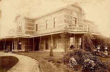
Photograph, [Miss Beatrice Henty in the Garden of Tarring], 1904
... Kew) in 1920. ‘Tarring’ was renamed ‘Henty House’ by Ruyton Girls' School in honour of its original owners. Ruyton Girls' School was founded in 1878, Miss Beatrice Henty attended the School before 1888. The photograph is dated c.1904. ruyton girls' school kew beatrice henty henry henty marion henty tarring henty house selbourne road beatrice blandy Kew (Vic) 1900s 1904 Sepia toned photograph Miss Beatrice Henty in the garden of her family home Tarring, Selbourne Road, Kew. The north east ...Beatrice Charlotte Henty was born 25 December 1867, married Graham Frederick Blandy in 1927 and died on 5 March 1950 in Toorak. She did not have any children. Miss Beatrice Henty was the daughter of Henry and Marion Henty. Mr Henry Henty and his wife Mrs Marion Anne Henty (nee McKellar) had ‘Tarring’, Kew built for their family in 1872, and resided there until the death of Marion Henty in 1919. ‘Tarring’ was then sold to Ruyton Girls’ School, and the School moved to the site, (now 12 Selbourne Rd, Kew) in 1920. ‘Tarring’ was renamed ‘Henty House’ by Ruyton Girls' School in honour of its original owners. Ruyton Girls' School was founded in 1878, Miss Beatrice Henty attended the School before 1888. The photograph is dated c.1904. Sepia toned photograph Miss Beatrice Henty in the garden of her family home Tarring, Selbourne Road, Kew. The north east and south facades of the two story brick house are visible in the photo. Beatrice Henty is standing in the garden wearing a long gown and a large hat. A gravel path curves across the lower left corner of the photograph. The photograph is mounted on card.ruyton girls' school, kew, beatrice henty, henry henty, marion henty, tarring, henty house, selbourne road, beatrice blandy, kew (vic), 1900s, 1904 -
 Kew Historical Society Inc
Photograph - Victorian Villa, High Street, c.1922
... houses - maxton - high street - kew (vic.) violet farm estate subdivisions - kew (vic.) Photographer's name on photograph, lower right, and stamp on mount lower right: "A. Aberline, Glenferrie". An old inscription on this photograph identifies it as ‘an elegant timber villa in High Street. It occupied part of Lot 91, bought by Edward Glyn in the land sale of 16th October 1851, and run as a flower farm’. The subdivision called the ‘Flower Farm Estate’ in East ...Subdivision plans are historically important documents used as evidence of the growth of suburbs in Australia. They frequently provide information about when the land was sold on which a built structure was subsequently constructed as well as evidence relating to surveyors and real estate and financial agents. The numerous subdivision plans in the Kew Historical Society's collection represent working documents, ranging from the initial sketches made in planning a subdivision to printed plans on which auctioneers or agents listed the prices for which individual lots were sold. In a number of cases, the reverse of a subdivision plan in the collection includes a photograph of a house that was also for sale by the agent. These photographs provide significant heritage information relating house design and decoration, fencing and household gardens.An old inscription on this photograph identifies it as ‘an elegant timber villa in High Street. It occupied part of Lot 91, bought by Edward Glyn in the land sale of 16th October 1851, and run as a flower farm’. The subdivision called the ‘Flower Farm Estate’ in East Kew occurred in 1922. [The subdivision plan is on the reverse of this photo.] The Estate included 61 lots on either side of Boorool Road between High Street and Harp Road. In the MMBW Detail Plan 2017 of 1926, a number of these new villas had already been built. Matching houses with MMBW maps can always be a challenge, however if this house was near the corner of Boorool Road and High Street, it seems to fit the profile of a house called ‘Maxton’ (demolished).Photographer's name on photograph, lower right, and stamp on mount lower right: "A. Aberline, Glenferrie".houses - maxton - high street - kew (vic.), violet farm estate, subdivisions - kew (vic.) -
 Kew Historical Society Inc
Photograph - 8 roomed DF Brick Villa, Kew, J E Barnes, c.1920
... house: "Kew, 3 minutes from tram, 8 roomed DF Brick Villa, tile roof including two attics, sleepout, bathroom, heater, E Light, Entrance Hall, double doors, leadlights, laundry, garden, lawns, land 75 x 170, 1975 pounds". Also photographers inscription on mount, lower left: J. E. Barnes / Photo / Phone 1966 Haw. KEW. A photograph, mounted on board of a double fronted Federation-era brick villa in Kew, photographed for a local real estate agent and financier by J. E. Barnes of Kew. On the reverse of the photograph is a subdivision plan for the Normanby Estate, East ...Subdivision plans are historically important documents used as evidence of the growth of suburbs in Australia. They frequently provide information about when the land was sold on which a built structure was subsequently constructed as well as evidence relating to surveyors and real estate and financial agents. The numerous subdivision plans in the Kew Historical Society's collection represent working documents, ranging from the initial sketches made in planning a subdivision to printed plans on which auctioneers or agents listed the prices for which individual lots were sold. In a number of cases, the reverse of a subdivision plan in the collection includes a photograph of a house that was also for sale by the agent. These photographs provide significant heritage information relating house design and decoration, fencing and household gardens. The photograph is of additional aesthetic significance as it was photographed by J. E. Barnes. Josiah Earl Barnes is a nationally significant photographer. He was also the most important photographer to have worked in Kew. He was active as a photographer in the district from c.1906 until his death in 1921. Best known as 'the Embarkation Photographer' (see the Australian War Memorial collection), J. Earl Barnes was also the official photographer employed by the Borough (and later Town, then City) of Kew. He clearly also completed commercial jobs for local businesses, as is the case in this photograph of a house for a local real estate and financial agent.A photograph, mounted on board of a double fronted Federation-era brick villa in Kew, photographed for a local real estate agent and financier by J. E. Barnes of Kew. On the reverse of the photograph is a subdivision plan for the Normanby Estate, East Kew - 2016.0039.1. As can be seen from the image, there is a large tear on the surface of the photograph.The brown card on which the photograph is mounted includes the following handwritten description, which may aid the identification of the house: "Kew, 3 minutes from tram, 8 roomed DF Brick Villa, tile roof including two attics, sleepout, bathroom, heater, E Light, Entrance Hall, double doors, leadlights, laundry, garden, lawns, land 75 x 170, 1975 pounds". Also photographers inscription on mount, lower left: J. E. Barnes / Photo / Phone 1966 Haw. KEW.j. e. barnes, josiah earl barnes, j. earl banes - photographer, architecture - federation style, houses - kew, real estate photographs -
 Kew Historical Society Inc
Photograph - Brick and Stucco Bungalow, J E Barnes, c.1920
... Kew photographer, Josiah Earl Barnes. The photo is of a weatherboard or brick rendered bungalow with a twisted wire fence. Given Barnes' status a a Kew photographer, the house is probably locate din Kew or East Kew. ...houses - kew, bungalows - kew real estate photographs j.e. barnes -- photographer Handwritten, mostly illegible description by selling agent on mount surround: " .... in Diningroom, Drawing Rooms, ... Photographers details printed on mount: "J. E. Barnes / Photo / Phone 1966 Haw KEW" Real estate photograph for a local agent by the Kew photographer, Josiah Earl Barnes. The photo is of a weatherboard or brick rendered bungalow with a twisted wire fence. Given Barnes' status a a Kew photographer, the house is probably locate din Kew or East ...The Kew Historical Society's map collection includes a substantial number of real estate subdivision plans, mainly of Kew but also of surrounding suburbs in Melbourne. Most of the subdivision plans date from the 1920s and 1930s when the districts old homes and local farmland were being split up to accommodate residential growth in the postwar period. These early plans were assembled by a local firm, Jas R Mather & McMillan, which had an office in Cotham Road. Many of the plans, and sometimes photos, were annotated by the agents.Subdivision plans are historically important documents used as evidence for the growth of suburbs in Australia. They frequently provide information about when the land was sold as well as evidence relating to surveyors and real estate and financial agents. The numerous subdivision plans in the Kew Historical Society's collection represent working documents, ranging from the initial sketches made in planning a subdivision to printed plans on which auctioneers or agents listed the prices for which individual lots were sold. In a number of cases, the reverse of a subdivision plan in the collection includes a photograph of a house that was also for sale by the agent. These photographs provide significant heritage information relating house design and decoration, fencing and household gardens.The photograph may also be aesthetically significant depending o the importance of the photographic atelier.Real estate photograph for a local agent by the Kew photographer, Josiah Earl Barnes. The photo is of a weatherboard or brick rendered bungalow with a twisted wire fence. Given Barnes' status a a Kew photographer, the house is probably locate din Kew or East Kew. Unfortunately the handwritten information on the mount bordering the photo is damaged and cannot be read. The bungalow has a gabled, tiled roof with terra cotta finials at the front of both gables. The house has a central doorway, framed by a pseudo portico supported by four wooden columns. On each side of the doorway, at the front, there are paired sash windows, which, like the half-timbered gable, are picked out in a darker colour.Handwritten, mostly illegible description by selling agent on mount surround: " .... in Diningroom, Drawing Rooms, ... Photographers details printed on mount: "J. E. Barnes / Photo / Phone 1966 Haw KEW"houses - kew, bungalows - kew, real estate photographs, j.e. barnes -- photographer -
 Kew Historical Society Inc
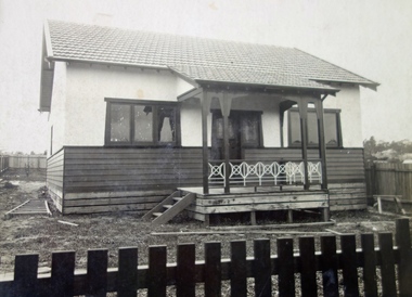
Photograph - Cottage, probably East Kew, A. Aberline, 1920s
... house, which was advertised for sale, has not to date been identified. The real estate photograph is mounted on the reverse of a subdivision plan for the Harvest Home Estate, Kew East. Photograph Cottage, probably East Kew ...The Kew Historical Society's map collection includes a substantial number of real estate subdivision plans, mainly of Kew but also of surrounding suburbs in Melbourne. Most of the subdivision plans date from the 1920s and 1930s when the districts old homes and local farmland were being split up to accommodate residential growth in the postwar period. These early plans were assembled by a local firm, Jas R Mather & McMillan, which had an office in Cotham Road. Many of the plans, and sometimes photos, were annotated by the agents.Subdivision plans are historically important documents used as evidence for the growth of suburbs in Australia. They frequently provide information about when the land was sold as well as evidence relating to surveyors and real estate and financial agents. The numerous subdivision plans in the Kew Historical Society's collection represent working documents, ranging from the initial sketches made in planning a subdivision to printed plans on which auctioneers or agents listed the prices for which individual lots were sold. In a number of cases, the reverse of a subdivision plan in the collection includes a photograph of a house that was also for sale by the agent. These photographs provide significant heritage information relating house design and decoration, fencing and household gardens.The photograph may also be aesthetically significant depending on the importance of the photographic atelier.An elevated, modest weatherboard house, photographed towards the end of the construction phase. The lower section of the weatherboards are exposed and stained. The upper section is rendered with rough-cast. The tiled roof has a single gable that extends over the centrally placed front porch. On the porch, the door and single sidelight are filled with coloured leadlight whereas the casement windows in the front rooms contain plain glass. The leadlight and the wrought iron of the verandah are the only decorative elements of the utilitarian design. The location of the house, which was advertised for sale, has not to date been identified. The real estate photograph is mounted on the reverse of a subdivision plan for the Harvest Home Estate, Kew East.Photographer's stamp, lower right on mount: "A. Aberline, Glenferrie"houses - kew, bungalows - kew, real estate photographs -
 Kew Historical Society Inc
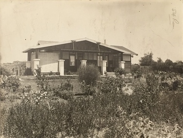
Photograph - Bungalow, probably East Kew, 1920s
... house, which was advertised for sale, has to date not been identified. The real estate photo is on the reverse of a plan for the Myrtle Hill Subdivision, Kew. Photograph Bungalow, probably East Kew ...The Kew Historical Society's map collection includes a substantial number of real estate subdivision plans, mainly of Kew but also of surrounding suburbs in Melbourne. Most of the subdivision plans date from the 1920s and 1930s when the districts old homes and local farmland were being split up to accommodate residential growth in the postwar period. These early plans were assembled by a local firm, Jas R Mather & McMillan, which had an office in Cotham Road. Many of the plans, and sometimes photos, were annotated by the agents.Subdivision plans are historically important documents used as evidence for the growth of suburbs in Australia. They frequently provide information about when the land was sold as well as evidence relating to surveyors and real estate and financial agents. The numerous subdivision plans in the Kew Historical Society's collection represent working documents, ranging from the initial sketches made in planning a subdivision to printed plans on which auctioneers or agents listed the prices for which individual lots were sold. In a number of cases, the reverse of a subdivision plan in the collection includes a photograph of a house that was also for sale by the agent. These photographs provide significant heritage information relating house design and decoration, fencing and household gardens.The photograph may also be aesthetically significant depending on the importance of the photographic atelier.An unusual bungalow that does not conform to a particular architectural style but which contains eclectic elements of the style of varying periods. The most striking element of the design is the cantilevered veranda that is supported by heavy chains that are attached to the central gable. This deep gable extends across most of the façade, forming an extensive veranda. Parts of this are infilled with screens. Seven wooden posts, whose lower halves are encased in rendered brick pillars, support this gabled veranda. The roof would appear to be covered with corrugated iron. The location of the house, which was advertised for sale, has to date not been identified. The real estate photo is on the reverse of a plan for the Myrtle Hill Subdivision, Kew.bungalows - kew, architecture - 1920s, real estate photographs -
 Kew Historical Society Inc
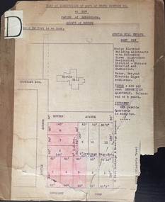
Plan - Subdivision Plan, J R Mathers & McMillan, Myrtle Hill Estate, East Kew, circa 1949, c.1949
... These photographs provide significant heritage information relating house design and decoration, fencing and household gardens.The photograph may also be aesthetically significant depending on the importance of the photographic atelier. The full (typed) title of this subdivision plan is :"Plan of SUBDIVISION of part of CROWN PORTION 83. / at KEW / PARISH OF BOROONDARA. / COUNTY OF BOURKE". / "MYRTLE HILL ESTATE / EAST KEW" In addition to the Title and subtitle, the plan also lists the advantages of the subdivision. ...The Kew Historical Society's map collection includes a substantial number of real estate subdivision plans, mainly of Kew but also of surrounding suburbs in Melbourne. Most of the subdivision plans date from the 1920s and 1930s when the districts old homes and local farmland were being split up to accommodate residential growth in the postwar period. These early plans were assembled by a local firm, Jas R Mather & McMillan, which had an office in Cotham Road. Many of the plans, and sometimes photos, were annotated by the agents.Subdivision plans are historically important documents used as evidence for the growth of suburbs in Australia. They frequently provide information about when the land was sold as well as evidence relating to surveyors and real estate and financial agents. The numerous subdivision plans in the Kew Historical Society's collection represent working documents, ranging from the initial sketches made in planning a subdivision to printed plans on which auctioneers or agents listed the prices for which individual lots were sold. In a number of cases, the reverse of a subdivision plan in the collection includes a photograph of a house that was also for sale by the agent. These photographs provide significant heritage information relating house design and decoration, fencing and household gardens.The photograph may also be aesthetically significant depending on the importance of the photographic atelier.Myrtle Hill, at 14 Vista Avenue, Kew, is of local historical and architectural significance as a good example of a large and imposing single-storey Italianate house of the early 1870s surviving in Kew. Originally sited on a large allotment overlooking Normanby Road, the setting of the house has been dramatically altered through extensive subdivision and development. The subdivision plan of the ‘Myrtle Hill Estate’ indicates that in one such subdivision, 11 allotments were created fronting Bowyer Avenue, Myrtle Avenue, and Normanby Road. The outline and building profile of Myrtle Hill is shown on the west side of Bowyer Avenue.The full (typed) title of this subdivision plan is :"Plan of SUBDIVISION of part of CROWN PORTION 83. / at KEW / PARISH OF BOROONDARA. / COUNTY OF BOURKE". / "MYRTLE HILL ESTATE / EAST KEW" In addition to the Title and subtitle, the plan also lists the advantages of the subdivision. -
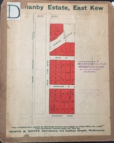 Kew Historical Society Inc
Plan - Subdivision Plan, J R Mathers & McMillan, Normanby Estate, c.1913
... These photographs provide significant heritage information relating house design and decoration, fencing and household gardens.The photograph may also be aesthetically significant depending on the importance of the photographic atelier. weir street - kew, wharton street - kew, normanby road - kew, cotham road - kew, municipal gardens - kew, park hill parkhill road - kew, braemar - kew subdivision plans - kew "D" in top left corner. Stamped auctioneers contact details: "Jas. R. Mathers & Son & McMillan / Auctioneer & Land Salesmen, / 271 Collins Street / Melbourne" and Jas. R. Mathers / Estate & Financial Agent / Cotham Road / Kew". The Normanby Estate, which was adjacent to Normanby Road, Kew East ...The Kew Historical Society's map collection includes a substantial number of real estate subdivision plans, mainly of Kew but also of surrounding suburbs in Melbourne. Most of the subdivision plans date from the 1920s and 1930s when the districts old homes and local farmland were being split up to accommodate residential growth in the postwar period. These early plans were assembled by a local firm, Jas R Mather & McMillan, which had an office in Cotham Road. Many of the plans, and sometimes photos, were annotated by the agents.Subdivision plans are historically important documents used as evidence for the growth of suburbs in Australia. They frequently provide information about when the land was sold as well as evidence relating to surveyors and real estate and financial agents. The numerous subdivision plans in the Kew Historical Society's collection represent working documents, ranging from the initial sketches made in planning a subdivision to printed plans on which auctioneers or agents listed the prices for which individual lots were sold. In a number of cases, the reverse of a subdivision plan in the collection includes a photograph of a house that was also for sale by the agent. These photographs provide significant heritage information relating house design and decoration, fencing and household gardens.The photograph may also be aesthetically significant depending on the importance of the photographic atelier.The Normanby Estate, which was adjacent to Normanby Road, Kew East, included thirty-one lots for sale. Streets on the subdivision plan include Adeney Avenue, Park Hill Road, Normanby Road, Weir Street and Wharton Street. Cotham Road and its tramway are shown nearby. The plan is interesting as it shows Wharton Street, named after the architect and town planner George Wharton, who was the first chairman of the Municipality of Kew. The street was to later be renamed Cecil Street. Also shown are proposed ‘Municipal Gardens’ where Parkhill Drive is now located."D" in top left corner. Stamped auctioneers contact details: "Jas. R. Mathers & Son & McMillan / Auctioneer & Land Salesmen, / 271 Collins Street / Melbourne" and Jas. R. Mathers / Estate & Financial Agent / Cotham Road / Kew".weir street - kew, wharton street - kew, normanby road - kew, cotham road - kew, municipal gardens - kew, park hill parkhill road - kew, braemar - kew, subdivision plans - kew -
 Kew Historical Society Inc
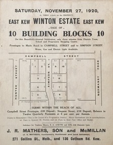
Plan - Subdivision Plan, Winton Estate, East Kew : Sale of 10 Building Blocks, 1920
... Kew Historical Society's collection represent working documents, ranging from the initial sketches made in planning a subdivision to printed plans on which auctioneers or agents listed the prices for which individual lots were sold. In a number of cases, the reverse of a subdivision plan in the collection includes a photograph of a house that was also for sale by the agent. These photographs provide significant heritage information relating house design and decoration, fencing and household gardens.The photograph may also be aesthetically significant depending on the importance of the photographic atelier. campbell street, simpson street, hunter street, normanby road - kew subdivision plans - east kew subdivision plans - kew Subdivision plan for the so-called Winton Estate in East Kew. ...The Kew Historical Society's map collection includes a substantial number of real estate subdivision plans, mainly of Kew but also of surrounding suburbs in Melbourne. Most of the subdivision plans date from the 1920s and 1930s when the districts old homes and local farmland were being split up to accommodate residential growth in the postwar period. These early plans were assembled by a local firm, Jas R Mather & McMillan, which had an office in Cotham Road. Many of the plans, and sometimes photos, were annotated by the agents.Subdivision plans are historically important documents used as evidence for the growth of suburbs in Australia. They frequently provide information about when the land was sold as well as evidence relating to surveyors and real estate and financial agents. The numerous subdivision plans in the Kew Historical Society's collection represent working documents, ranging from the initial sketches made in planning a subdivision to printed plans on which auctioneers or agents listed the prices for which individual lots were sold. In a number of cases, the reverse of a subdivision plan in the collection includes a photograph of a house that was also for sale by the agent. These photographs provide significant heritage information relating house design and decoration, fencing and household gardens.The photograph may also be aesthetically significant depending on the importance of the photographic atelier.Subdivision plan for the so-called Winton Estate in East Kew. The Estate comprised 10 lots facing Simpson Street and Campbell Street. The estate was auctioned by Jas. R. Mathers, Son and McMillan. campbell street, simpson street, hunter street, normanby road - kew, subdivision plans - east kew, subdivision plans - kew -
 Kew Historical Society Inc
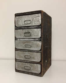
Furniture - Toolbox constructed from recycled materials
... Kew Historical Society Inc Kew Court House 188 High Street Kew melbourne Toolbox, made by Salvation Army Brigadier Warren Trestrail (1895-1971), during the Great Depression from recycled kerosene tins and packing boxes. It proved to be a useful piece of furniture as the family moved around Australia during various postings within the Australian States and Territories. In World War II, Warren Trestrail embarked with the first convoy of soldiers from Australia to the Middle East ...Toolbox, made by Salvation Army Brigadier Warren Trestrail (1895-1971), during the Great Depression from recycled kerosene tins and packing boxes. It proved to be a useful piece of furniture as the family moved around Australia during various postings within the Australian States and Territories. In World War II, Warren Trestrail embarked with the first convoy of soldiers from Australia to the Middle East and served as Salvation Army welfare officer through the Libyan campaign, at Tobruk, and in Greece. In 1942, it was announced that Salvation Army war services at Darwin would be placed under his direction. He had previously been in charge of South Australian war activities. The item was donated to the Society in 2001 by Sadie Trestrail, who had been a teacher at Kew East Primary School for many years. It is a fine example of vernacular furniture made of recycled materials .Depression-era toolbox constructed from recycled kerosene tins and parts of wooden packing boxes. The five tin drawers are made of sections of kerosene tins with handles soldered to the centre of each new drawer. A number of drawers have separators constructed of tin or aluminium. The wooden planks encasing the the drawers are covered with a degraded shellac coating. An analysis of the interior indicates that the brand names of the original parts are largely extant. furniture - recycled - depession era - 1930s, great depression - 1930s - australia, warren trestrail, salvation army, vernacular furniture -
 Kew Historical Society Inc
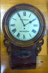
Functional object, H Newman, Boxed Wall Clock, 19th Century
... Kew Jeweller and watchmaker. East side between Denmark Street and Cotham Road. roy cronin - watchmaker - jeweller - kew (vic) h newman - melbourne (vic) - collins street - jeweller - clockmaker Wood, enamel, brass and glass wall clock, the movement made by H Newman of Collins Street, Melbourne. A small label on the interior records the name R. Cronin, 156 High St, Kew, 1/7/20. It is unclear whether Cronin, a watchmaker and jeweller may have repaired or sold the clock. The clock (broken) is housed ...DEATH OF MR. H. NEWMAN. Widespread regret will be felt at the announcement of the death of Mr Henry Newman, an old colonist and a member of firm of Newman and Sons Proprietary Limited, jewellers, which occurred at his residence, "Sadova," William street, on Saturday, at the age of 89 years. Mr Newman who was born at Riga, in Russia, went to England when a lad, became naturalised, and emigrated to Victoria 61 years ago. He tried his fortune at Ballarat but soon afterwards returned to Melbourne, and began business as a jeweller, on a site in Collins street that is now occupied by Scott's Hotel. A few years later Mr Newman went back to England, where he was married. On his return to Victoria again he resumed his jewellery business in Elizabeth street opposite the General Post-office. An interesting fact in connection with his business is that his first journeyman watchmaker was Mr. Thomas Gaunt, the founder of the firm of Messrs. T. Gaunt & Co. Five years ago Mr. Newman retired from the business, which has since been carried on by his two elder sons. Although he took no active part in public affairs, Mr Newman was held in high regard on account of his business integrity, sterling personal worth. and the unostentatious way in which he did good. His vitality, even in his later years, was wonderful. On four occasions he met with accidents, having been twice knocked down by motorcars and twice by trams, without having sustained injury. A widow and grown up family of four sons and four daughters survive him. The Age Monday 27 October 1913, page 9. Roy Cronin 156 High Street Kew Jeweller and watchmaker. East side between Denmark Street and Cotham Road. Wood, enamel, brass and glass wall clock, the movement made by H Newman of Collins Street, Melbourne. A small label on the interior records the name R. Cronin, 156 High St, Kew, 1/7/20. It is unclear whether Cronin, a watchmaker and jeweller may have repaired or sold the clock. The clock (broken) is housed in a steel box.roy cronin - watchmaker - jeweller - kew (vic), h newman - melbourne (vic) - collins street - jeweller - clockmaker -
 Kew Historical Society Inc
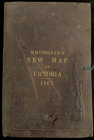
Map, Whitehead's Map of Victoria, With Alphabetical Key, 1869, 1869
... Kew Historical Society Inc Kew Court House 188 High Street Kew melbourne When E. Whitehead's New Map of Victoria was released in 1869, an advertisement in the Bendigo Advertiser (16 July 1869) noted that: "This beautifully engraved Map has been revised and brought down to the present time; and, with the Alphabetical Key, is the most complete and the cheapest Map ever published; Price, 6d plain; 1s colored; 2s 6d in case; on linen, post free, 2d extra. E.. WHITEHEAD and CO, Publishers, 67 Collins-street east ...When E. Whitehead's New Map of Victoria was released in 1869, an advertisement in the Bendigo Advertiser (16 July 1869) noted that: "This beautifully engraved Map has been revised and brought down to the present time; and, with the Alphabetical Key, is the most complete and the cheapest Map ever published; Price, 6d plain; 1s colored; 2s 6d in case; on linen, post free, 2d extra. E.. WHITEHEAD and CO, Publishers, 67 Collins-street east." The following year, 1870, Whitehead's promoted the edition in the Portland Guardian and Normanby General Advertiser (3 January 1870), advising that: "WHITEHEAD'S NEW MAP OF VICTORIA, 1869 ... is corrected to the latest date, and around is arranged an Alphabetical Key, with Post Towns and Money Order Olffices marked. The Map being divided into squares and numbered, by reference to the Key any place can be found immediately. Price Is beautifully colored, or mounted on linen in case, 2s 6d. Post free, 2d extra, in Victoria. B. Whitehead and C0., Puolishers, 67 Collins-street East, Melbourne". In the same edition of the Portland Advertiser, they also promoted their business generally, saying: "E WHITEHEAD and Co., Stationers, Engravers, Lithographers, 67 Collins street East, execute every description of Lithographic PRINTING, BILL-HEADS. NOTE Headings. Business Dies Engraved and Embossed on Envelopes &c. ARMS, MONOGRAMS, AND CRESTS Engraved and Embossed in Colour, superior to any other house in the Colony. Specimens, post free, 2d. Lithographers, &c, to H.R.H. the Duke of Edinburgh, and Die-inkers and Embossers to His Excellency Sir J. H. T. Manners-Sutton, K C.B. Orders executed for the Trade". Whitehead’s New Map of Victoria 1869 is is an important record of region created towards the end of the Victorian Gold Rush (1851-1869). In addition to its historical significance, this is a rare map, of which the only known copies in Australian public collections are those held at the National Library of Australia, the State Library of Victoria, State Library of New South Wales and the University of Queensland Library.Map of Victoria with gold mining areas, notes on topography, transport routes. Relief shown by hachures. List of towns with distance from Melbourne in map margin. [Melbourne] : Printed & Published by ... E Whitehead & Co ... 67 Collins Street East, 1869 1 map : col., mounted on linen ; 38.4 x 55.4 cm, folded to 18 x 12 cm.Cover "WHITEHEAD'S NEW MAP OF VICTORIA 1869"maps - victoria - 1860s, e whitehead's new map of victoria 1869, whitehead's map of victoria with alphabetical key 1869, cartography, gold rush -
 Kew Historical Society Inc
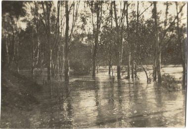
Photograph, Marnie McLeod, Floods of the River Yarra at Kew, 1916
... houses he owns off Young-street have been flooded out. Having been warned in time, the tenants removed their furniture hefore the water came down to Mr. Laver's residence, where they themselves have been given accommodation in the meantime. All the river flats in East Kew are under water. One or two low-lying houses have been flooded. Chipperfield's boat shed at Willsmere is nearly covered, and some Chinese gardens in the vicinity are several feet under water." This, and the other three photographs donated of floods in Kew ...The donation was accompanied by the following letter from the donor: "Hi. I found these in with family photos. Taken by family as Mamie McLeod was living in Fellows Street, Kew, so would be near there. Retain (or discard) as you see fit." [Donor's name and address withheld from public view]. To gain an insight into the flood levels at Kew, it is worth reading newspaper accounts of the event. The Age published an article - Valuable Gardens Destroyed at Kew - on 25 September 1916: "VALUABLE GARDENS DESTROYED AT KEW. From the heights of Studley Park, Kew, a splendid view of the flood waters can be obtained, and yesterday afternoon, despite continuous rain, crowds of citizens assembled there to witness the spectacle. There is a vast stretch of water some 300 or 400 yards broad, above the foot bridge connecting Gipps-street, Collingwood, and Studley Park. The river is only about 3 feet from the top of the embankment connecting with the ramp of the bridge on the Studiey Park side. When the upper llood waters come down it is almost a certainty that tne embankment will be submerged and the bridge rendered impassible. Below the bridge the waters again stretch out, and have submerged all the low-lying land on the Collingwood side and invaded the back premises ot the Kodak Co., Phoenix Biscuit Factory, a tannery adjoining thereto, the Shamrock Brewery, and Chinese gardens in the vicinity. At Walmer-street-bridge, at the end of Studley Park, the low-lying land on the Kew side is covered with water to the depth of many feet. Tlie land in question is owned in a great part by Mr Frank Lavers who haa gone in for intense culture on a pretty liberal scale on both the slopes of the hill and on the river flat. On the latter he is cultivating many acres of asparagus, and has at a considerable cost spent three years in preparing the ground and installing an irrigation system, reticulated from the Yan Yean water supply. This year the asparagus was put down, and the plants were in a promising condition. Tlie flood waters are now flowing fast over the land. The crop is ruined, and three years' work and expenditure destroyed. Mr. Laver's private residence fortunately is high above flood level, but two houses he owns off Young-street have been flooded out. Having been warned in time, the tenants removed their furniture hefore the water came down to Mr. Laver's residence, where they themselves have been given accommodation in the meantime. All the river flats in East Kew are under water. One or two low-lying houses have been flooded. Chipperfield's boat shed at Willsmere is nearly covered, and some Chinese gardens in the vicinity are several feet under water."This, and the other three photographs donated of floods in Kew are believed to be the earliest in the collection. Together with our original MMBW River Yarra map showing flood levels, these items, when compared allow researchers to gain a visual perspective of the extent of the flood in 1916. Black and white photograph of flooded trees in Kew with rising dry ground in distance.Inscription on reverse in pencil: "Flood River Yarra Kew Vic"river yarra, kew, floods 1916 -
 Kew Historical Society Inc
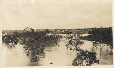
Photograph, Marnie McLeod, Floods on the River Yarra at Kew, 1916
... houses he owns off Young-street have been flooded out. Having been warned in time, the tenants removed their furniture hefore the water came down to Mr. Laver's residence, where they themselves have been given accommodation in the meantime. All the river flats in East Kew are under water. One or two low-lying houses have been flooded. Chipperfield's boat shed at Willsmere is nearly covered, and some Chinese gardens in the vicinity are several feet under water." This, and the other three photographs donated of floods in Kew ...The donation was accompanied by the following letter from the donor: "Hi. I found these in with family photos. Taken by family as Mamie McLeod was living in Fellows Street, Kew, so would be near there. Retain (or discard) as you see fit." [Donor's name and address withheld from public view]. To gain an insight into the flood levels at Kew, it is worth reading newspaper accounts of the event. The Age published an article - Valuable Gardens Destroyed at Kew - on 25 September 1916: "VALUABLE GARDENS DESTROYED AT KEW. From the heights of Studley Park, Kew, a splendid view of the flood waters can be obtained, and yesterday afternoon, despite continuous rain, crowds of citizens assembled there to witness the spectacle. There is a vast stretch of water some 300 or 400 yards broad, above the foot bridge connecting Gipps-street, Collingwood, and Studley Park. The river is only about 3 feet from the top of the embankment connecting with the ramp of the bridge on the Studiey Park side. When the upper llood waters come down it is almost a certainty that tne embankment will be submerged and the bridge rendered impassible. Below the bridge the waters again stretch out, and have submerged all the low-lying land on the Collingwood side and invaded the back premises ot the Kodak Co., Phoenix Biscuit Factory, a tannery adjoining thereto, the Shamrock Brewery, and Chinese gardens in the vicinity. At Walmer-street-bridge, at the end of Studley Park, the low-lying land on the Kew side is covered with water to the depth of many feet. Tlie land in question is owned in a great part by Mr Frank Lavers who haa gone in for intense culture on a pretty liberal scale on both the slopes of the hill and on the river flat. On the latter he is cultivating many acres of asparagus, and has at a considerable cost spent three years in preparing the ground and installing an irrigation system, reticulated from the Yan Yean water supply. This year the asparagus was put down, and the plants were in a promising condition. Tlie flood waters are now flowing fast over the land. The crop is ruined, and three years' work and expenditure destroyed. Mr. Laver's private residence fortunately is high above flood level, but two houses he owns off Young-street have been flooded out. Having been warned in time, the tenants removed their furniture hefore the water came down to Mr. Laver's residence, where they themselves have been given accommodation in the meantime. All the river flats in East Kew are under water. One or two low-lying houses have been flooded. Chipperfield's boat shed at Willsmere is nearly covered, and some Chinese gardens in the vicinity are several feet under water."This, and the other three photographs donated of floods in Kew are believed to be the earliest in the collection. Together with our original MMBW River Yarra map showing flood levels, these items, when compared allow researchers to gain a visual perspective of the extent of the flood in 1916. Panoramic view, believed to be looking north towards Fairfield from the Zig-Zag Bridge on the River Yarra. The inscription on the reverese identifies it as taken before 1920.Inscription on reverse in ink "(pre 1920) Flood from Zig-zag bridge Yarra River, Kew Vic."river yarra, kew, floods 1916, zig-zag bridge -
 Kew Historical Society Inc
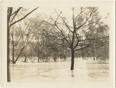
Photograph, Marnie McLeod, Flood, River Yarra, Kew, 1916
... houses he owns off Young-street have been flooded out. Having been warned in time, the tenants removed their furniture hefore the water came down to Mr. Laver's residence, where they themselves have been given accommodation in the meantime. All the river flats in East Kew are under water. One or two low-lying houses have been flooded. Chipperfield's boat shed at Willsmere is nearly covered, and some Chinese gardens in the vicinity are several feet under water." This, and the other three photographs donated of floods in Kew ...The donation was accompanied by the following letter from the donor: "Hi. I found these in with family photos. Taken by family as Mamie McLeod was living in Fellows Street, Kew, so would be near there. Retain (or discard) as you see fit." [Donor's name and address withheld from public view]. To gain an insight into the flood levels at Kew, it is worth reading newspaper accounts of the event. The Age published an article - Valuable Gardens Destroyed at Kew - on 25 September 1916: "VALUABLE GARDENS DESTROYED AT KEW. From the heights of Studley Park, Kew, a splendid view of the flood waters can be obtained, and yesterday afternoon, despite continuous rain, crowds of citizens assembled there to witness the spectacle. There is a vast stretch of water some 300 or 400 yards broad, above the foot bridge connecting Gipps-street, Collingwood, and Studley Park. The river is only about 3 feet from the top of the embankment connecting with the ramp of the bridge on the Studiey Park side. When the upper llood waters come down it is almost a certainty that tne embankment will be submerged and the bridge rendered impassible. Below the bridge the waters again stretch out, and have submerged all the low-lying land on the Collingwood side and invaded the back premises ot the Kodak Co., Phoenix Biscuit Factory, a tannery adjoining thereto, the Shamrock Brewery, and Chinese gardens in the vicinity. At Walmer-street-bridge, at the end of Studley Park, the low-lying land on the Kew side is covered with water to the depth of many feet. Tlie land in question is owned in a great part by Mr Frank Lavers who haa gone in for intense culture on a pretty liberal scale on both the slopes of the hill and on the river flat. On the latter he is cultivating many acres of asparagus, and has at a considerable cost spent three years in preparing the ground and installing an irrigation system, reticulated from the Yan Yean water supply. This year the asparagus was put down, and the plants were in a promising condition. Tlie flood waters are now flowing fast over the land. The crop is ruined, and three years' work and expenditure destroyed. Mr. Laver's private residence fortunately is high above flood level, but two houses he owns off Young-street have been flooded out. Having been warned in time, the tenants removed their furniture hefore the water came down to Mr. Laver's residence, where they themselves have been given accommodation in the meantime. All the river flats in East Kew are under water. One or two low-lying houses have been flooded. Chipperfield's boat shed at Willsmere is nearly covered, and some Chinese gardens in the vicinity are several feet under water."This, and the other three photographs donated of floods in Kew are believed to be the earliest in the collection. Together with our original MMBW River Yarra map showing flood levels, these items, when compared allow researchers to gain a visual perspective of the extent of the flood in 1916. Small black and white photograph of flooded trees in Kew.Inscription on reverse in ink "Flood R. Yarra Kew Vicriver yarra, kew, floods 1916 -
 Kew Historical Society Inc
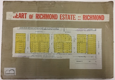
Plan - Subdivision Plan, J R Mathers & McMillan, Heart of Richmond Estate : Richmond, 1928
... Kew Historical Society Inc Kew Court House 188 High Street Kew melbourne "In 1928 the land on the east side of Johnson Street was subdivided in 60 lots for the ‘Heart of Richmond Estate’. ..."In 1928 the land on the east side of Johnson Street was subdivided in 60 lots for the ‘Heart of Richmond Estate’. The houses in the subdivision, along the east side of Johnson Street, and in the newly created Hollick, Cole and Kennedy streets were constructed from 1928 to 1937." (Source: City of Yarra Heritage Gaps Review One 2013)Portion of subdivision plan pasted on to cardboard. Area includes Johnson Street, Victoria Street, Kennedy Street, Cole Street, Hollick Street, Bennett StreetTitle Certificate Vol.2381, Folio 476130 Phillips, Fox & Masel, 440 Little Collins Street, Melbourne (Local estate agent: Jas. R. Mathers & McMIllan, 136 Cotham Road, Kew)subdivision plans - richmond (vic.), heart of richmond estate -
 Kew Historical Society Inc
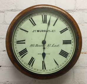
Functional object, Jas Murray & Co, Wall Clock & Key, 1860s
... Kew Historical Society Inc Kew Court House 188 High Street Kew melbourne The clock was purchased from Jas Murray & Co. of 107 Bourke Street East, Melbourne by Francis Barnard. ...The clock was purchased from Jas Murray & Co. of 107 Bourke Street East, Melbourne by Francis Barnard. James Murray & Co were well known clock and watchmakers operating from premises in London with branches in Calcutta and Melbourne. They were watchmakers and jewellers in Melbourne from 1860 to 1888. Francis Barnard established Barnard’s Pharmacy on the corner of Bulleen Road (later renamed High Street) and Cotham Road in 1857. In the early 1860s, after purchasing the clock, he placed it in his pharmacy where it could be seen by passers by. When he relocated across the road to 49 Bulleen Road (now 167 High St.) in 1880 he took the clock to the new premises. He maintained the accuracy of the clock so that local residents consulted it for the correct time, even after the Post Office building with its clock tower was opened in 1888. When Francis Barnard retired, his son took over the pharmacy. In 1925, the Barnard Pharmacy was sold to David Paton. The Paton’s were at first puzzled why people constantly peered in the door until they realised that the timepiece was the drawcard. When David Paton died in 1941, his widow sold the pharmacy but took the clock with her to her new florist shop at 145 High Street. When Mrs Paton retired in 1953, she took the clock to her home in Boronia. In 1973 her daughter donated the clock to the Kew Historical Society.Significant locally to Kew as an example of a timepiece that was used by the local community during the 19th century to tell the time.Barnard’s clock is a typical wall clock of the nineteenth century, variants of which could be seen in shops, offices, public buildings and stations. It has a mahogany case with a moulded wooden bezel encasing a hinged brass bezel housing the glass face which protects the dial and hands when working. The clock face has an off-white hand painted tin dial with black painted Roman numerals. The hands are black painted metal; the hour hand has a wide spade shaped point whilst the minute hand is much thinner. ‘Jas Murray & Co’ is painted above the centre, with ‘107 Bourke Street East’ and ‘Melbourne’ below, with the key hole in between. The clock movement is a fuse chain attached to a brass mainspring barrel which powers the pendulum for eight days. This is housed within a rectangular wooden casing with a convex curved base housing a hinged door giving access to the pendulum which is attached to the back of the clock by four wooden pegs.Jas Murray & Co / 107 Bourke St East / Melbournefrancis barnard, f g a barnard, high street - kew (vic), pharmacies - kew (vic), clocks, paton's pharmacy --- kew (vic.), bulleen road -- kew (vic.) -
 Kew Historical Society Inc
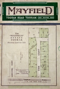
Plan - Subdivision Plan, Mayfield Estate, 1927
... Kew Historical Society Inc Kew Court House 188 High Street Kew melbourne A number of the plans in the Kew Historical Society’s collection can also be found in other collections, such as those of the State Library of Victoria. A number are however unique to the collection. The Kew Historical Society collection includes almost 100 subdivision plans pertaining to suburbs of the City of Melbourne. Most of these are of Kew, Kew East ...A number of the plans in the Kew Historical Society’s collection can also be found in other collections, such as those of the State Library of Victoria. A number are however unique to the collection.The Kew Historical Society collection includes almost 100 subdivision plans pertaining to suburbs of the City of Melbourne. Most of these are of Kew, Kew East or Studley Park, although a smaller number are plans of Camberwell, Deepdene, Balwyn and Hawthorn. It is believed that the majority of the plans were gifted to the Society by persons connected with the real estate firm - J. R. Mathers and McMillan, 136 Cotham Road, Kew. The Plans in the collection are rarely in pristine form, being working plans on which the agent would write notes and record lots sold and the prices of these. The subdivision plans are historically significant examples of the growth of urban Melbourne from the beginning of the 20th Century up until the 1980s. A number of the plans are double-sided and often include a photograph on the reverse. A number of the latter are by noted photographers such as J.E. Barnes.The Mayfield Estate subdivision included 14 allotments surrounding Evan Court (now Evans Court) in Toorak. The subdivision adjoined Toorak Road east of Kooyong Road and alerted prospective buyers to how the Toorak Road tram would take them directly to the city. This emphasis on existing transport routes was a feature of subdivisions during a period when car ownership was the preserve of the wealthy. An existing brick villa (‘Mayfield’) is noted as already constructed on lot 13. The subdivision also notes that the lots adjoin land owned by Sir Edward Miller. Today Evans Court extends beyond this subdivision through to Moonga Road.subdivision plans - toorak, mayfield estate, sir edward miller -
 Kew Historical Society Inc
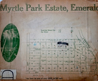
Plan - Subdivision Plan, Myrtle Park Estate, Emerald, 1915
... Kew Historical Society Inc Kew Court House 188 High Street Kew melbourne subdivision plans - emerald myrtle park estate Torley Road -- Emerald (Vic.) This subdivision plan for the ‘Myrtle Park Estate’ relates to land sales in Emerald, Victoria, rather than to the subdivision of the same name in East Kew (1913-16). ...This subdivision plan for the ‘Myrtle Park Estate’ relates to land sales in Emerald, Victoria, rather than to the subdivision of the same name in East Kew (1913-16). The subdivision in Emerald included 32 one-acre lots facing Torley Road, Government Road (now Rawhiti and Wong Hee Roads) Beaconsfield Road (now Old Beaconsfield Road). On the plan, an unnamed creek flows through allotments 8-12 on the east side of the Estate. The photograph of a waterfall and the advertised price of Day Return and Weekend Return Fares provide an indication of who the prospective purchasers were likely to be.subdivision plans - emerald, myrtle park estate, torley road -- emerald (vic.) -
 Kew Historical Society Inc
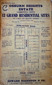
Plan - Subdivision Plan, Osburn Heights Estate, 1938
... Kew Historical Society Inc Kew Court House 188 High Street Kew melbourne subdivision plans - camberwell north osburn heights estate Edward Haughton & Co, in promoting the Osburn Heights Estate in what is now Balwyn North, attempted to capitalize on the subdivision’s proximity to East Kew. ...Edward Haughton & Co, in promoting the Osburn Heights Estate in what is now Balwyn North, attempted to capitalize on the subdivision’s proximity to East Kew. One section of the plan is includes the text: ‘The New Suburb: Camberwell North or East Kew (the names are synonymous)’. The Osburn Heights subdivision was part of a series of subdivisions running between Doncaster Road and Maud Street, including the ‘Pointed Firs Estate’ (MAP.0010). This subdivision included 13 ‘grand residential sites’ for sale in Doncaster Road, Maud Street and Osburn Avenue.subdivision plans - camberwell north, osburn heights estate -
 Kew Historical Society Inc
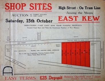
Plan - Subdivision Plan, Shop Sites, East Kew, c.1927
... Kew Historical Society's collection represent working documents, ranging from the initial sketches made in planning a subdivision to printed plans on which auctioneers or agents listed the prices for which individual lots were sold. In a number of cases, the reverse of a subdivision plan in the collection includes a photograph of a house that was also for sale by the agent. These photographs provide significant heritage information relating house design and decoration, fencing and household gardens. subdivision plans - east kew high street - east kew ...Subdivision plans are historically important documents used as evidence of the growth of suburbs in Australia. They frequently provide information about when the land was sold on which a built structure was subsequently constructed as well as evidence relating to surveyors and real estate and financial agents. The numerous subdivision plans in the Kew Historical Society's collection represent working documents, ranging from the initial sketches made in planning a subdivision to printed plans on which auctioneers or agents listed the prices for which individual lots were sold. In a number of cases, the reverse of a subdivision plan in the collection includes a photograph of a house that was also for sale by the agent. These photographs provide significant heritage information relating house design and decoration, fencing and household gardens.This is one of a small number of subdivision plans for commercial property in the collection. The subdivision proposed to create six shop sites in High Street between the Harp of Erin and Station Street. The plan shows this stretch of High Street, East Kew already lined with shops that include the hotel on the corner, the new State Savings Bank, a dentist’s surgery and Lambert’s Store. The High Street Tram was to reach Burke Road in 1925, so the proposed subdivision must postdate that event, and the opening of the Bank in 1926.subdivision plans - east kew, high street - east kew -
 Kew Historical Society Inc
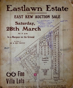
Plan - Subdivision Plan, Eastlawn Estate, 1914
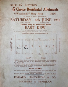
... Kew Historical Society's collection represent working documents, ranging from the initial sketches made in planning a subdivision to printed plans on which auctioneers or agents listed the prices for which individual lots were sold. In a number of cases, the reverse of a subdivision plan in the collection includes a photograph of a house that was also for sale by the agent. These photographs provide significant heritage information relating house design and decoration, fencing and household gardens. subdivision plans - east kew eastlawn estate The ‘Eastlawn Estate’ was surveyed and ready for auction in March 1914, three months before the outbreak of World War I. Sixty-six allotments, created on the ‘order of Mr & Miss Preston’ surrounded the mansion of Woodlands in Harp Road. Woodlands formed part of the Estate, being advertised as lot 1. The allotments faced High, Station and Wright Streets, Harp and Normanby Roads, and Woodlands Avenue. Pru Sanderson in the Kew ...Subdivision plans are historically important documents used as evidence of the growth of suburbs in Australia. They frequently provide information about when the land was sold on which a built structure was subsequently constructed as well as evidence relating to surveyors and real estate and financial agents. The numerous subdivision plans in the Kew Historical Society's collection represent working documents, ranging from the initial sketches made in planning a subdivision to printed plans on which auctioneers or agents listed the prices for which individual lots were sold. In a number of cases, the reverse of a subdivision plan in the collection includes a photograph of a house that was also for sale by the agent. These photographs provide significant heritage information relating house design and decoration, fencing and household gardens.The ‘Eastlawn Estate’ was surveyed and ready for auction in March 1914, three months before the outbreak of World War I. Sixty-six allotments, created on the ‘order of Mr & Miss Preston’ surrounded the mansion of Woodlands in Harp Road. Woodlands formed part of the Estate, being advertised as lot 1. The allotments faced High, Station and Wright Streets, Harp and Normanby Roads, and Woodlands Avenue. Pru Sanderson in the Kew Conservation Study (Vol.2, 1988) wrote that the Eastlawn Estate ‘covered the western half of the failed Harp of Erin Estate’. Contemporary advertisements promoted the Eastlawn Estate as: ‘There will be no more convenient district nor pleasant Suburb than East Kew for the busy business man. When the Electric Tram is laid, he will be able to journey quickly and pleasantly direct from Collins Street to his home in the Eastlawn Estate in about 20 minutes’. The actual plans of subdivision were included in advertisements in The Argus and in the local newspapers.subdivision plans - east kew, eastlawn estate -
 Kew Historical Society Inc
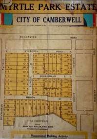
Plan - Subdivision Plan, Myrtle Park Estate, City of Camberwell, 1916
... Kew Historical Society Inc Kew Court House 188 High Street Kew melbourne The Kew Historical Society collection includes almost 100 subdivision plans pertaining to suburbs of the City of Melbourne. Most of these are of Kew, Kew East ...The Kew Historical Society collection includes almost 100 subdivision plans pertaining to suburbs of the City of Melbourne. Most of these are of Kew, Kew East or Studley Park, although a smaller number are plans of Camberwell, Deepdene, Balwyn and Hawthorn. It is believed that the majority of the plans were gifted to the Society by persons connected with the real estate firm - J. R. Mathers and McMillan, 136 Cotham Road, Kew. The Plans in the collection are rarely in pristine form, being working plans on which the agent would write notes and record lots sold and the prices of these. The subdivision plans are historically significant examples of the growth of urban Melbourne from the beginning of the 20th Century up until the 1980s. A number of the plans are double-sided and often include a photograph on the reverse. A number of the latter are by noted photographers such as J.E. Barnes.The ‘Myrtle Park Estate’ was a subdivision bounded by Victoria Road (now Lansdowne Street), Buchanan Avenue and Dight Avenue. Other streets that were created by the subdivision included Eurolie Street, Boorahman Street and Moody Street (now Sylvan Street). The Estate took its name from Myrtle Park (later changed to Macleay Park), which had been created in 1923 by Camberwell Council. The Park adjoined the southeast corner of the new subdivision. The Estate included 74 regular allotments characterised by narrow frontages and long blocks. Confusion may have greeted prospective purchasers as the Estate was advertised in the daily newspapers as being in East Kew, rather than in Camberwell, where it was at that stage located.subdivision plans - balwyn, myrtle park estate - camberwell [surrey hills] -
 Kew Historical Society Inc
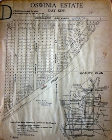
Plan - Subdivision Plan, Oswinia Estate, East Kew, c.1925
... Kew Historical Society's collection represent working documents, ranging from the initial sketches made in planning a subdivision to printed plans on which auctioneers or agents listed the prices for which individual lots were sold. In a number of cases, the reverse of a subdivision plan in the collection includes a photograph of a house that was also for sale by the agent. These photographs provide significant heritage information relating house design and decoration, fencing and household gardens. subdivision plans - east kew oswinia estate high street, glass street, namur street, government boulevard - kilby road, irymple street, oswin street The ‘Oswinia Estate’ subdivision in East Kew was planned and auctioned in the first half of the 1920s. 169 allotments were created in the triangular section of land bordered by High Street, Burke Road and the Government Boulevard (later Kilby Road). ...Prue Sanderson, in her groundbreaking ‘City of Kew Urban Conservation Study : Volume 2 - Development History’ (1988), summarised the periods of urban development and subdivisions of land in Kew. The periods that she identified included 1845-1880, 1880-1893, 1893-1921, 1921-1933, 1933-1943, and Post-War Development. These periods were selected as they represented periods of rapid growth or decline in urban development. An obvious starting point for Sanderson’s groupings involved population growth and the associated economic cycles. These cycles also highlighted urban expansion onto land that was predominantly rural, although in other cases it represented the decline and breakup of large estates. A number of the plans in the Kew Historical Society’s collection can also be found in other collections, such as those of the State Library of Victoria and the Boroondara Library Service. A number are however unique to the collection.Subdivision plans are historically important documents used as evidence of the growth of suburbs in Australia. They frequently provide information about when the land was sold on which a built structure was subsequently constructed as well as evidence relating to surveyors and real estate and financial agents. The numerous subdivision plans in the Kew Historical Society's collection represent working documents, ranging from the initial sketches made in planning a subdivision to printed plans on which auctioneers or agents listed the prices for which individual lots were sold. In a number of cases, the reverse of a subdivision plan in the collection includes a photograph of a house that was also for sale by the agent. These photographs provide significant heritage information relating house design and decoration, fencing and household gardens.The ‘Oswinia Estate’ subdivision in East Kew was planned and auctioned in the first half of the 1920s. 169 allotments were created in the triangular section of land bordered by High Street, Burke Road and the Government Boulevard (later Kilby Road). The only piece of land excluded was that where the previous Kew Pound had been located at the east tip of the triangle. Allotments were created fronting Glass, High, Namur, Oswin Streets, Irymple Avenue, and the Government Boulevard. The name for the Estate was derived from Oswin’s farm, which had been one of the largest landholdings in East Kew. The selling agents annotated the plan in our collection with crosses indicating those lots that had been sold. The inset locality plan is particularly interesting as it shows the route and stations of the Outer Circle Railway. When the subdivision plan was created, it included the proposed bridge over the Yarra at Burke Road. The bridge was to be officially opened in 1926.subdivision plans - east kew, oswinia estate, high street, glass street, namur street, government boulevard - kilby road, irymple street, oswin street -
 Kew Historical Society Inc
Plan - Subdivision Plan, Central Park Estate, Deepdene - Camberwell, 1923
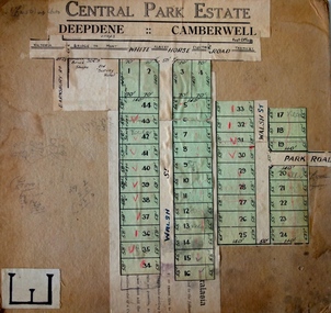
... Kew Historical Society Inc Kew Court House 188 High Street Kew melbourne The Kew Historical Society collection includes almost 100 subdivision plans pertaining to suburbs of the City of Melbourne. Most of these are of Kew, Kew East ...The Kew Historical Society collection includes almost 100 subdivision plans pertaining to suburbs of the City of Melbourne. Most of these are of Kew, Kew East or Studley Park, although a smaller number are plans of Camberwell, Deepdene, Balwyn and Hawthorn. It is believed that the majority of the plans were gifted to the Society by persons connected with the real estate firm - J. R. Mathers and McMillan, 136 Cotham Road, Kew. The Plans in the collection are rarely in pristine form, being working plans on which the agent would write notes and record lots sold and the prices of these. The subdivision plans are historically significant examples of the growth of urban Melbourne from the beginning of the 20th Century up until the 1980s. A number of the plans are double-sided and often include a photograph on the reverse. A number of the latter are by noted photographers such as J.E. Barnes.An agent’s board on which parts of an advertisement for the Central Park Estate have been pasted. [The State Library of Victoria holds a complete plan]. Whereas the original plan included black and white photographs and effusive prose about the virtues of the Estate, the item in our collection includes only the actual blocks. The agent has annotated particular blocks to indicate that they have been sold.subdivision plans - deepdene - camberwell, central park estate -
 Kew Historical Society Inc
Plan - Subdivision Plan, 6 Choice Residential Allotments: East Kew, 1932
... Kew Historical Society's collection represent working documents, ranging from the initial sketches made in planning a subdivision to printed plans on which auctioneers or agents listed the prices for which individual lots were sold. In a number of cases, the reverse of a subdivision plan in the collection includes a photograph of a house that was also for sale by the agent. These photographs provide significant heritage information relating house design and decoration, fencing and household gardens. subdivision plans - kew woodlands estate The mansion Woodlands in Harp Road, East Kew ...Prue Sanderson, in her groundbreaking ‘City of Kew Urban Conservation Study : Volume 2 - Development History’ (1988), summarised the periods of urban development and subdivisions of land in Kew. The periods that she identified included 1845-1880, 1880-1893, 1893-1921, 1921-1933, 1933-1943, and Post-War Development. These periods were selected as they represented periods of rapid growth or decline in urban development. An obvious starting point for Sanderson’s groupings involved population growth and the associated economic cycles. These cycles also highlighted urban expansion onto land that was predominantly rural, although in other cases it represented the decline and breakup of large estates. A number of the plans in the Kew Historical Society’s collection can also be found in other collections, such as those of the State Library of Victoria and the Boroondara Library Service. A number are however unique to the collection.Subdivision plans are historically important documents used as evidence of the growth of suburbs in Australia. They frequently provide information about when the land was sold on which a built structure was subsequently constructed as well as evidence relating to surveyors and real estate and financial agents. The numerous subdivision plans in the Kew Historical Society's collection represent working documents, ranging from the initial sketches made in planning a subdivision to printed plans on which auctioneers or agents listed the prices for which individual lots were sold. In a number of cases, the reverse of a subdivision plan in the collection includes a photograph of a house that was also for sale by the agent. These photographs provide significant heritage information relating house design and decoration, fencing and household gardens.The mansion Woodlands in Harp Road, East Kew suffered the death of a thousand cuts. In its case, the cuts were subdivisions. Previous subdivisions of the mansion and its grounds were given titles such as ‘The Eastlawn Estate’ (MAP.0055), whereas at the end, the subdivision called it as it was, naming itself the ‘final section of the Woodlands Estate’ when it was put up for auction in 1932. The emphasis in the promotion of the subdivision was that it provided purchasers with splendid opportunities ‘to build modern homes in select, well established modern surroundings’. As with other subdivisions in the interwar period, transport links were emphasised. The six residential lots cut Woodlands off from Harp Road. When the vendor, Louisa Rachel Preston Hill, was to die at Woodlands in 1937 aged 86 her address was given as Normanby Road.subdivision plans - kew, woodlands estate -
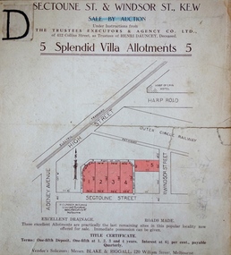 Kew Historical Society Inc
Plan, J R Mathers & McMillan, 5 Splendid vVlla Allotments,: Segtoune St. & Windsor St., Kew, 1928
... house design and decoration, fencing and household gardens. subdivision plans - kew segtoune street -- kew (vic.) windsor street -- kew (vic.) In 1928, five residential allotments bordering Segtoune and Windsor Streets were advertised for sale as part of a subdivision. Four of the blocks faced Segtoune Avenue. The auctioneers proclaimed the advantages of the sites: ‘Situate one minute from the High Street Electric Tram, which now runs direct to Spencer Street via Bridge Road and Flinders Street. Opposite the East ...Prue Sanderson, in her groundbreaking ‘City of Kew Urban Conservation Study : Volume 2 - Development History’ (1988), summarised the periods of urban development and subdivisions of land in Kew. The periods that she identified included 1845-1880, 1880-1893, 1893-1921, 1921-1933, 1933-1943, and Post-War Development. These periods were selected as they represented periods of rapid growth or decline in urban development. An obvious starting point for Sanderson’s groupings involved population growth and the associated economic cycles. These cycles also highlighted urban expansion onto land that was predominantly rural, although in other cases it represented the decline and breakup of large estates. A number of the plans in the Kew Historical Society’s collection can also be found in other collections, such as those of the State Library of Victoria and the Boroondara Library Service. A number are however unique to the collection.Subdivision plans are historically important documents used as evidence of the growth of suburbs in Australia. They frequently provide information about when the land was sold on which a built structure was subsequently constructed as well as evidence relating to surveyors and real estate and financial agents. The numerous subdivision plans in the Kew Historical Society's collection represent working documents, ranging from the initial sketches made in planning a subdivision to printed plans on which auctioneers or agents listed the prices for which individual lots were sold. In a number of cases, the reverse of a subdivision plan in the collection includes a photograph of a house that was also for sale by the agent. These photographs provide significant heritage information relating house design and decoration, fencing and household gardens.In 1928, five residential allotments bordering Segtoune and Windsor Streets were advertised for sale as part of a subdivision. Four of the blocks faced Segtoune Avenue. The auctioneers proclaimed the advantages of the sites: ‘Situate one minute from the High Street Electric Tram, which now runs direct to Spencer Street via Bridge Road and Flinders Street. Opposite the East Kew Railway Station (Outer Circle Line), which may be reopened In connection with the new Line from Kew to Doncaster; Adjacent lo the Kew Recreation Reserve, Sports Oval, and Swimming Bath; Half Minute from the Shopping Centre of East Kew, Accessible to the State School and Other Educational Centres’. The Harp of Erin Hotel and the route of the Outer Circle Railway line are marked on the plan. The Recreation Reserve and Sport Oval refer to Victoria Park. The Swimming Baths were located on the site of the current Kew Recreation Centre.subdivision plans - kew, segtoune street -- kew (vic.), windsor street -- kew (vic.) -
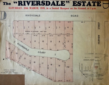 Kew Historical Society Inc
Plan - Subdivision Plan, Riversdale Estate, 1939
... Kew Historical Society Inc Kew Court House 188 High Street Kew melbourne The Kew Historical Society collection includes almost 100 subdivision plans pertaining to suburbs of the City of Melbourne. Most of these are of Kew, Kew East ...The Kew Historical Society collection includes almost 100 subdivision plans pertaining to suburbs of the City of Melbourne. Most of these are of Kew, Kew East or Studley Park, although a smaller number are plans of Camberwell, Deepdene, Balwyn and Hawthorn. It is believed that the majority of the plans were gifted to the Society by persons connected with the real estate firm - J. R. Mathers and McMillan, 136 Cotham Road, Kew. The Plans in the collection are rarely in pristine form, being working plans on which the agent would write notes and record lots sold and the prices of these. The subdivision plans are historically significant examples of the growth of urban Melbourne from the beginning of the 20th Century up until the 1980s. A number of the plans are double-sided and often include a photograph on the reverse. A number of the latter are by noted photographers such as J.E. Barnes.The Riversdale Estate in Hawthorn created a subdivision of 20 allotments bordering on Riversdale Road and Riversdale Court (which was created by the subdivision). The Locality Plan at right lists the major public buildings in the area: Burnely Horticultural Gardens, Hawthorn Tram Depot and Railway Station, Scotch College and the River Yarra and The Boulevard.subdivision plans - hawthorn, riversdale estate