Showing 5106 items matching "housing development"
-
 Sunshine and District Historical Society Incorporated
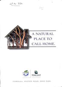
Pamphlet - Cairnlee Housing Development "A Natural Place to Call Home", Urban land corporation, 2001
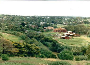
... Cairnlee Housing Development "A Natural Place to Call Home"...Ilustrated brochure on new housing development, Cairnle , on the site of former Albion explosives factory...Cairnlee Ilustrated brochure on new housing development, Cairnle , on the site of former Albion explosives factory Pamphlet Cairnlee Housing Development "A Natural Place to Call Home" Urban land corporation ...cairnlee -
 Port Melbourne Historical & Preservation Society
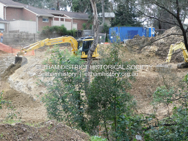
Photograph - Becton housing development, Gasworks, corner Graham and Pickles Streets, Ron Laing, 2000
... Becton housing development, Gasworks, corner Graham and Pickles Streets...A set of 14 colour photographs covering the construction of the Becton housing development on the old Port Melbourne Gasworks site, corner Graham and Pickles Streets 2000...Donated to the PMH&PS by the photographer. built environment ron laing A set of 14 colour photographs covering the construction of the Becton housing development on the old Port Melbourne Gasworks site, corner Graham and Pickles Streets 2000 Photograph Becton housing development, Gasworks, corner Graham and Pickles Streets Ron Laing ...Part of Ron Laing's collection of photographs recording Port Melbourne over a thirteen year period. Donated to the PMH&PS by the photographer.A set of 14 colour photographs covering the construction of the Becton housing development on the old Port Melbourne Gasworks site, corner Graham and Pickles Streets 2000built environment, ron laing -
Port Melbourne Historical & Preservation Society
Plan - CD-ROM, State Savings Bank, Montague Housing Development
... CD-ROM, State Savings Bank, Montague Housing Development...COPYRIGHT PUBLIC RECORDS OFFICE Set of plans and documents relating to the State Savings bank, Montague Housing Development, in Gladstone St, Montague. This was an initiative of South Melbourne City Council to replace slum housing in Montague, 1935-40 .01 - The DVD which contains all the information....Plan CD-ROM, State Savings Bank, Montague Housing Development ...COPYRIGHT PUBLIC RECORDS OFFICE Set of plans and documents relating to the State Savings bank, Montague Housing Development, in Gladstone St, Montague. This was an initiative of South Melbourne City Council to replace slum housing in Montague, 1935-40 .01 - The DVD which contains all the information.built environment - domestic, state savings bank of victoria -
Port Melbourne Historical & Preservation Society
Plan - Montague Housing Development
... Montague Housing Development...COPYRIGHT PUBLIC RECORDS OFFICE Set of plans and documents relating to the State Savings bank, Montague Housing Development, in Gladstone St, Montague. This was an initiative of South Melbourne City Council to replace slum housing in Montague, 1935-40 .02 - 41 A4 pages including index, copies (some laminated)...Port Melbourne Historical & Preservation Society Port Melbourne Town Hall 333 Bay Street Port Melbourne melbourne built environment - domestic state savings bank of victoria COPYRIGHT PUBLIC RECORDS OFFICE Set of plans and documents relating to the State Savings bank, Montague Housing Development, in Gladstone St, Montague. This was an initiative of South Melbourne City Council to replace slum housing in Montague, 1935-40 .02 - 41 A4 pages including index, copies (some laminated) Plan Montague Housing Development ...COPYRIGHT PUBLIC RECORDS OFFICE Set of plans and documents relating to the State Savings bank, Montague Housing Development, in Gladstone St, Montague. This was an initiative of South Melbourne City Council to replace slum housing in Montague, 1935-40 .02 - 41 A4 pages including index, copies (some laminated)built environment - domestic, state savings bank of victoria -
Port Melbourne Historical & Preservation Society
Plan - Montague Housing Development
... Montague Housing Development...COPYRIGHT PUBLIC RECORDS OFFICE Set of plans and documents relating to the State Savings bank, Montague Housing Development, in Gladstone St, Montague. This was an initiative of South Melbourne City Council to replace slum housing in Montague, 1935-40 .03 - 40 pages; .04 - 7 pages of A2 copies (some laminated)...Original source Public Records Office Built Environment - Domestic State Savings Bank of Victoria COPYRIGHT PUBLIC RECORDS OFFICE Set of plans and documents relating to the State Savings bank, Montague Housing Development, in Gladstone St, Montague. This was an initiative of South Melbourne City Council to replace slum housing in Montague, 1935-40 .03 - 40 pages; .04 - 7 pages of A2 copies (some laminated) Plan Montague Housing Development ...Provided to PMHPS by Steve Tserkezidis and follows on from his earlier materials on the Port Melbourne State Bank houses. See item 2824. Original source Public Records OfficeCOPYRIGHT PUBLIC RECORDS OFFICE Set of plans and documents relating to the State Savings bank, Montague Housing Development, in Gladstone St, Montague. This was an initiative of South Melbourne City Council to replace slum housing in Montague, 1935-40 .03 - 40 pages; .04 - 7 pages of A2 copies (some laminated)built environment - domestic, state savings bank of victoria -
 Eltham District Historical Society Inc
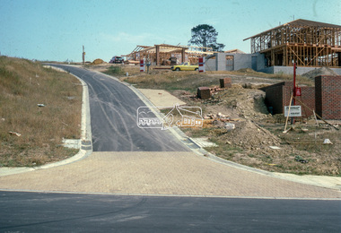
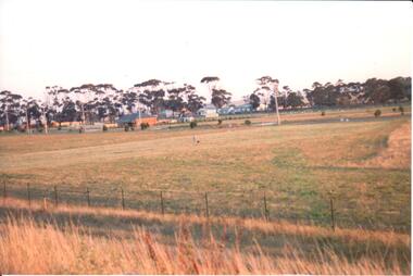
Slide - Photograph, Road infrastucture, new housing development, most likely Templestowe, c.Mar. 1985
... Road infrastucture, new housing development, most likely Templestowe...In this case, the street is most likely a private street scheme in a new housing development in what is present-day Manningham City Council. ...In this case, the street is most likely a private street scheme in a new housing development in what is present-day Manningham City Council. ...Eltham Shire Council officers would benchmark road infrastructure in surrounding local government areas. In this case, the street is most likely a private street scheme in a new housing development in what is present-day Manningham City Council. Areas of interest in the phioto are the roll over concrete kerbs, brick paving at road entrace and drainage.35mm colour positive transparency (1 of 15) Mount - Kodak Kodachrome Cardinfrastructure, roads, city of manningham, footpaths and gutters, housing estates, unidentified, templestowe -
 Hume City Civic Collection
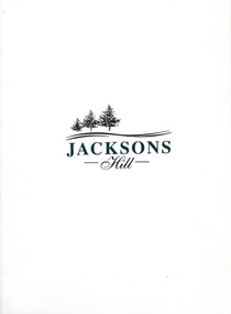
Document, Jacksons Hill, 21st June 1996
... ...Housing Development...Since then the Urban Land Authority was appointed to draw up plans for housing and recreational development....A white cardboard folder containing 7 sheets of plans outlining the proposed housing development of Jacksons Hill in Sunbury....Jackson's Hill Sunbury Asylum Caloola Urban Land Authority Roslyn Kalbrunner Housing Development A white cardboard folder containing 7 sheets of plans outlining the proposed housing development of Jacksons Hill in Sunbury. ...Jacksons Hill was the former site of the Sunbury Asylum ( Caloola), which closed down in 1992. Since then the Urban Land Authority was appointed to draw up plans for housing and recreational development.The former Sunbury Asylum played an important part in Sunbury's development for over 120 years.A white cardboard folder containing 7 sheets of plans outlining the proposed housing development of Jacksons Hill in Sunbury.jackson's hill, sunbury asylum, caloola, urban land authority, roslyn kalbrunner, housing development -
Port Melbourne Historical & Preservation Society
Drawing - Artist's impression of proposed Car Court Housing Group development, 1994
... Artist's impression of proposed Car Court Housing Group development...Housing Group...Bayside Development...A photocopy of an artist's impression of the Car Court Housing Group as proposed for the Beacon Cove Bayside development. The drawing was prepared by Mirvac for the Office of Major Projects by the firm of Henry Pollock and Associates....Drawing Artist's impression of proposed Car Court Housing Group development ...A photocopy of an artist's impression of the Car Court Housing Group as proposed for the Beacon Cove Bayside development. The drawing was prepared by Mirvac for the Office of Major Projects by the firm of Henry Pollock and Associates.port melbourne foreshore, built environment - domestic, beacon cove, car court housing group, bayside development -
 Sunshine and District Historical Society Incorporated
Archive - Housing & Local Development Articles, Various, 1989 -1999
... Housing & Local Development Articles...Local development and housing issues articles. Part of E. ...Archive Housing & Local Development Articles Various ...See itemshouse -
Port Melbourne Historical & Preservation Society
Audio - PMHPS Meeting, Steve Tserkizidis, Hosuing in Garden City, John Kirby, 27 Jan 2014
... ...Montague Housing development...Steve Tserkizidis talks about housing development in Garden City and Victorian Public Recoprds Office. ...Steve Tserkizidis talks about housing development in Garden City and Victorian Public Recoprds Office. ...PMHPS meeting on 27.01.2014. Steve Tserkizidis talks about housing development in Garden City and Victorian Public Recoprds Office. Duration 01:02:50 (includes meeting preliminaries) .02 - CD of abovebuilt environment - domestic, garden city estate development, public records office victoria, dunston housing estate, state savings bank of victoria, montague housing development -
 Sunshine and District Historical Society Incorporated
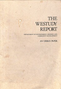
Booklet - The Westudy Report - An Urban Paper, Australian Government Publising Service Canberra, 1975
... The Westudy Report - An Urban Paper A report to the Minister for Enviroment, Housing and Community Development on the information and library needs of the citizens of the Western Region of Melbourne prepared jointly by the Library Council of Voctoria and the Victorian Counicl of Sociel Service...Department of Enviroment, Housing and Community Development...See preliminary release of The Westudy Report (Cat No 3266) Weststudy The Westudy Report - An Urban Paper A report to the Minister for Enviroment, Housing and Community Development on the information and library needs of the citizens of the Western Region of Melbourne prepared jointly by the Library Council of Voctoria and the Victorian Counicl of Sociel Service Soft covered report in a book format The Westudy Report - An Urban Paper Booklet The Westudy Report - An Urban Paper Australian Government Publising Service Canberra Department of Enviroment, Housing and Community Development ...Soft covered report in a book formatweststudy -
 Hume City Civic Collection
Photograph, early 1990s
... It was a large housing development built close to Sunbury township....A coloured photograph of a new housing development taken in Anderson Road looking west towards Elizabeth Drive and the leisure centre. ...It was a large housing development built close to Sunbury township. housing developments anderson road george evans collection A coloured photograph of a new housing development taken in Anderson Road looking west towards Elizabeth Drive and the leisure centre. ...The series of 5 photographs feature different views of the Woodlands housing development which opened up land bounded by Gap and Anderson Roads, Cornish Street and Elizabeth Drive in the early 1990s. It was a large housing development built close to Sunbury township.A coloured photograph of a new housing development taken in Anderson Road looking west towards Elizabeth Drive and the leisure centre. Some housing construction is in the middle distance.housing developments, anderson road, george evans collection -
 Hume City Civic Collection
Photograph
... Housing development spread to the banks of the Jacksons Creek at the east end of the town in the late 1970s....A coloured landscape photograph overlooking the Jacksons Creek and Sunbury township and showing housing development which is taking place on the horse shore bend also known as blueberry island on the opposite creek bank....Hume City Civic Collection 44 Macedon Street Sunbury melbourne Housing development spread to the banks of the Jacksons Creek at the east end of the town in the late 1970s. jacksons creek blueberry island george evans collection A coloured landscape photograph overlooking the Jacksons Creek and Sunbury township and showing housing development which is taking place on the horse shore bend also known as blueberry island on the opposite creek bank. ...Housing development spread to the banks of the Jacksons Creek at the east end of the town in the late 1970s.A coloured landscape photograph overlooking the Jacksons Creek and Sunbury township and showing housing development which is taking place on the horse shore bend also known as blueberry island on the opposite creek bank.jacksons creek, blueberry island, george evans collection -
 Hume City Civic Collection
Photograph, early 1990s
... It was a large housing development built close to Sunbury township....A view of the northern boundary of the Woodlands housing development in Anderson Road. A paling fence divides the estate from the 'Malley' factory, now 'Storage King' which is on the corner of Cornish Street and Anderson Road. ...It was a large housing development built close to Sunbury township. housing developments anderson road george evans collection A view of the northern boundary of the Woodlands housing development in Anderson Road. ...The series of 5 photographs feature different views of the Woodlands housing development which opened up land bounded by Gap and Anderson Roads, Cornish Street and Elizabeth Drive in the early 1990s. It was a large housing development built close to Sunbury township.A view of the northern boundary of the Woodlands housing development in Anderson Road. A paling fence divides the estate from the 'Malley' factory, now 'Storage King' which is on the corner of Cornish Street and Anderson Road. A 'For Sale' sign is in the foreground and a partly built house is in the middle distance.housing developments, anderson road, george evans collection -
 Hume City Civic Collection
Photograph, early 1990s
... It was a large housing development built close to Sunbury township....A coloured photograph of one of the last housing developments which took place in the old township area. ...It was a large housing development built close to Sunbury township. housing developments anderson road george evans collection A coloured photograph of one of the last housing developments which took place in the old township area. ...The series of 5 photographs feature different views of the Woodlands Housing Development which opened up land bounded by Gap and Anderson Roads, Cornish Street and Elizabeth Drive in the early 1990s. It was a large housing development built close to Sunbury township.A coloured photograph of one of the last housing developments which took place in the old township area. It is a photograph taken at the north end of Anderson Road looking towards Gap Road. One house has been built and there are a number of 'For Sale' signs of blocks fronting Anderson Road. Guttering and driveways have been formed on one side of the road.housing developments, anderson road, george evans collection -
 Sunshine and District Historical Society Incorporated
Photograph - Black Powder Mill Photograph, C2009
... Colour photograph of the Black Powder Mill with new housing developments in the far background...Black Powder Mill from Tom Rigg 11/6/2004 Colour photograph of the Black Powder Mill with new housing developments in the far background Photograph Black Powder Mill Photograph ...Black Powder Mill from Tom Rigg 11/6/2004 -
 Hume City Civic Collection
Photograph, Unknown
... Some housing development is evident amongst the gum trees which are across the middle distance....Hume City Civic Collection 44 Macedon Street Sunbury melbourne housing developments george evans collection A coloured photograph of a new housing development. ...A coloured photograph of a new housing development. There is a low metal and wire fence across the foreground and an open area immediately beyond the fence. Some housing development is evident amongst the gum trees which are across the middle distance.housing developments, george evans collection -
 Eltham District Historical Society Inc
Photograph (Item) - Print, Jocelyn Zepter-Trevor, Their Driveway, 1988
... ...Housing development...It is a time capsule of life in the 1980s of this urban and rural municipality in Melbourne's north. shire of eltham archives Bicentennial Project Eltham Eltham Community Photographic Survey Eltham Photographic Survey Exhibition Series 34 Series 35 Film - Agfa XR 100 i Housing development Housing estate Jocelyn Zepter-Trevor Real Estate Development Scan - 35mm negative Front: Entrant No. and name on printed label Rear: Entrant No., name and address on printed label; also 'Series 34' and the 'Item No.' in pencil Colour print 20.5 x 25.5 cm mounted on card 25.4 x 30.4 cm Also corresponding negative (Series 35) Digital image scanned from negative (Series 35) Their Driveway Photograph Print Jocelyn Zepter-Trevor ...Jocelyn Zepter-Trevor 1988 Entrant No. 69 Ref: Series 34, Item 24 SHIRE OF ELTHAM COMMUNITY PHOTOGRAPHIC SURVEY Photography is an artform which many of us practice, sometimes purely for artistic pursuit, sometimes to record the people and events in our lives. In 1988, as part of a local Bicentennial project, the Shire of Eltham conducted the Eltham Community Photographic Survey. Up to 100 entries were to be selected by a panel of photographers for entry into the Eltham Photographic Survey Exhibition. Entries had to be submitted by May 13, 1988. Entrants whose images were selected for the exhibition were contacted and requested to further submit an entry form providing entrant’s name, area of residence, age, and proposed captions. These details were then used to produce labels for the exhibition mounts. Where negatives had not been supplied, these were requested to support the display of printed enlargements mounted on 10” x 8” cardboard. The mounted prints were made available post exhibition for sale at $8.50 each for colour prints and $7.00 for B&W prints. Residents in the Shire were invited to collect a free roll of film and take a photograph of what they either liked or did not like about the area. A total of 160 entrants submitted multiple entries for the exhibition. Of those selected for exhibition, entrants ranged in age from 9 to 70 years. All custom colour and black and white printing for the exhibition was completed by Wattle Studios of Eltham. The Eltham Photographic Survey was jointly auspiced by the Shire of Eltham and Wattle Studios, of 953 Main Road, Eltham. The project was greatly assisted by: • David McRitchie, Media Studies Lecturer Victoria College, Rusden Campus. • Ian and Annette Toohill of Wattle Studios • Tracy Naughton, Eltham Community Arts Officer • Neville Emerson Pty. Ltd. • Superior Press, Eltham • Kodak Australasia Pty. Ltd. • Agfa Gevaert Ltd. • Townsend Colourtech Pty. Ltd. • The Australian Bicentennial Authority • Eleanor Bowers, Secretary, Eltham Arts Council The exhibition was placed on display in the Woolworths Arcade, Eltham between Monday June 6th and Saturday June 11, 1988. It was also intended to hold the exhibition at a venue in the Shire’s North Riding from Monday, June 20 to Friday June 24. It was then displayed at the Were Street Theatre, Montmorency from Friday, June 24 to Thursday, July 7. Series 34: Eltham Community Photographic Survey 1988 - Prints & Documentation Series consists of 117 photographs of Shire scenes taken by members of the community. Items I - 41 are larger photographs mounted on card, which were exhibited. Items 42 - 117 are unmounted copies, alternative takes and other entries. Corresponding negatives contained in Series 35: Eltham Community Photographic Survey 1988 – Negatives which consists of 267 colour and B&W negatives and one colour slide of Shire scenes taken by members of the community. The negatives are arranged by the entrant number of the photographer. The Eltham Community Photographic Survey collection is significant to the local community as it was curated by the local community - ordinary people of all ages - representing what they liked and did not like in the area where they lived. It represents an unfiltered representation of the Shire of Eltham as it was in 1988. It also represents one of many projects as part of the national programme of events and celebrations to commemorate the bicentenary. It is a time capsule of life in the 1980s of this urban and rural municipality in Melbourne's north. Front: Entrant No. and name on printed label Rear: Entrant No., name and address on printed label; also 'Series 34' and the 'Item No.' in pencilshire of eltham archives, bicentennial project, eltham, eltham community photographic survey, eltham photographic survey exhibition, series 34, series 35, film - agfa xr 100 i, housing development, housing estate, jocelyn zepter-trevor, real estate development, scan - 35mm negative -
 Port Melbourne Historical & Preservation Society
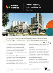
Flyer, Barak Beacon Fact Sheet, 20 November 2023
... A fact sheet developed by Homes Victoria with information regarding the proposed Barak Beacon housing development. ...Built Environment - Public Housing HomesVictoria Barak Beacon A fact sheet developed by Homes Victoria with information regarding the proposed Barak Beacon housing development. Barak Beacon Fact Sheet Flyer ...A fact sheet developed by Homes Victoria with information regarding the proposed Barak Beacon housing development. built environment - public housing, homesvictoria, barak beacon -
Port Melbourne Historical & Preservation Society
Flyer, Barak Beacon Fact Sheet, 20 November 2023
... A fact sheet developed by Homes Victoria with information regarding the proposed Barak Beacon housing development. ...Built Environment - Public Housing HomesVictoria Barak Beacon A fact sheet developed by Homes Victoria with information regarding the proposed Barak Beacon housing development. Barak Beacon Fact Sheet Flyer ...A fact sheet developed by Homes Victoria with information regarding the proposed Barak Beacon housing development. built environment - public housing, homesvictoria, barak beacon -
 Eltham District Historical Society Inc
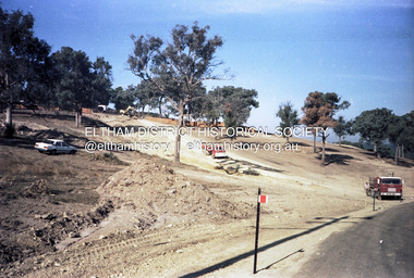
Photograph, Daryl Morrow, Redevelopment of former site of Hassall's Roadside Gallery, Main Road, Eltham, 10 July 2023
... ...Housing development...Daryl Morrow Collection Eltham Heights Luxury Living hassalls roadside gallery Housing development Real Estate Development Research Creek 2023-07-10 7 images - born digital Redevelopment of former site of Hassall's Roadside Gallery, Main Road, Eltham Photograph Photograph Daryl Morrow ...This historic site of Australia’s first open-air gallery is being redeveloped in 2023 for multi-housing fronting the Research Creek. In 1955, Ian and Joan Hassall moved to Eltham. They took a property on the corner of Zig Zag Road and Main Road, Eltham, north of the township (later known as 1215 Main Road). In July 1962, they opened their open-air gallery. Hassall’s Roadside Galley, “…cradled in the fold of hills to the north of Eltham” inspired by Ian’s own experience of exhibitions along the Embankment in London. The property included remnants of a stone quarry, paintings were hung on screens and removed at night. Various pedestals, that looked like giant mushrooms displayed sculpture, pottery, and jewellery. It had a small natural amphitheatre at the foot of a little sandstone cliff that fall away to the bed of a stream. To enter the gallery, a visitor crossed a small freestone bridge of oriental design, built by Hassall from local stone. The bridge spanned the stream flowing beneath great willow trees. Near the entrance wooden figures were displayed formed from pieces of local wood, said to speak to Ian Hassall’s sense of fun. Hassall’s Gallery was the first gallery of its kind in Australia. Ian became a full-time artist and when it first opened, he exhibited paintings he had made while touring the outback with writer and fellow Eltham resident Alan Marshall. He also exhibited other Australian artists over time including locals Lindsay Edward and Peter Glass.daryl morrow collection, eltham heights luxury living, hassalls roadside gallery, housing development, real estate development, research creek, 2023-07-10 -
 Eltham District Historical Society Inc
Photograph, Daryl Morrow, Redevelopment of former site of Hassall's Roadside Gallery, Main Road, Eltham, 13 July 2023
... ...Housing development...Daryl Morrow Collection Eltham Heights Luxury Living hassalls roadside gallery Housing development Real Estate Development Research Creek 2023-07-13 4 images - born digital Redevelopment of former site of Hassall's Roadside Gallery, Main Road, Eltham Photograph Photograph Daryl Morrow ...This historic site of Australia’s first open-air gallery is being redeveloped in 2023 for multi-housing fronting the Research Creek. In 1955, Ian and Joan Hassall moved to Eltham. They took a property on the corner of Zig Zag Road and Main Road, Eltham, north of the township (later known as 1215 Main Road). In July 1962, they opened their open-air gallery. Hassall’s Roadside Galley, “…cradled in the fold of hills to the north of Eltham” inspired by Ian’s own experience of exhibitions along the Embankment in London. The property included remnants of a stone quarry, paintings were hung on screens and removed at night. Various pedestals, that looked like giant mushrooms displayed sculpture, pottery, and jewellery. It had a small natural amphitheatre at the foot of a little sandstone cliff that fall away to the bed of a stream. To enter the gallery, a visitor crossed a small freestone bridge of oriental design, built by Hassall from local stone. The bridge spanned the stream flowing beneath great willow trees. Near the entrance wooden figures were displayed formed from pieces of local wood, said to speak to Ian Hassall’s sense of fun. Hassall’s Gallery was the first gallery of its kind in Australia. Ian became a full-time artist and when it first opened, he exhibited paintings he had made while touring the outback with writer and fellow Eltham resident Alan Marshall. He also exhibited other Australian artists over time including locals Lindsay Edward and Peter Glass.daryl morrow collection, eltham heights luxury living, hassalls roadside gallery, housing development, real estate development, research creek, 2023-07-13 -
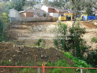
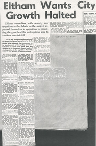 Eltham District Historical Society Inc
Document - Newspaper article, Diamond Valley News, Eltham Wants City Growth Halted, 31 Mar 1960
... ...Housing development...Eltham District Historical Society Inc 728 Main Rd Eltham melbourne Eltham Council objects to unrestricted growth of Melbourne Metropolitan area Eltham Housing development Melbourne Metropolitan area Urban Growth A3 photocopy Eltham Wants City Growth Halted Document Newspaper article Diamond Valley News ...Eltham Council objects to unrestricted growth of Melbourne Metropolitan areaeltham, housing development, melbourne metropolitan area, urban growth -
Whitehorse Historical Society Inc.
Document, Viewings, 1998
... 'Viewings', Melbourne Edition One 1998, by Australand, detailing housing developments in Blackburn South, 'Illowra Views', and other areas....Whitehorse Historical Society Inc. 2-10 Deep Creek Road Mitcham melbourne fulton road blackburn south illowra walk illowra views australand land subdivision centre road vermont arlington heights estate heatherdale road rowan street arlington walk 'Viewings', Melbourne Edition One 1998, by Australand, detailing housing developments in Blackburn South, 'Illowra Views', and other areas. ...'Viewings', Melbourne Edition One 1998, by Australand, detailing housing developments in Blackburn South, 'Illowra Views', and other areas.fulton road, blackburn south, illowra walk, illowra views, australand, land subdivision, centre road, vermont, arlington heights estate, heatherdale road, rowan street, arlington walk -
Port Melbourne Historical & Preservation Society
Flyer - Barak Beacon Information Sheet, 20 November 2023
... Homes Victoria information sheet naming Building Communities as their project partner in the development of the proposed Barak Beacon housing development. ...Built Environment - Public Housing HomesVictoria Barak Beacon 20/11/23 Homes Victoria information sheet naming Building Communities as their project partner in the development of the proposed Barak Beacon housing development. ...Homes Victoria information sheet naming Building Communities as their project partner in the development of the proposed Barak Beacon housing development. 20/11/23built environment - public housing, homesvictoria, barak beacon -
Canterbury History Group
Article, Change the rules - Save the neighbourhood, 1/08/1999 12:00:00 AM
... Article from the Boroondara Bulletin, August 1999, on new housing developments the City of Borondara believes are threatening the character of our neighbourhoods...Canterbury History Group 190A Canterbury Road Canterbury melbourne Canterbury City of Boroondara Good Design Code Town Planning Houses Article from the Boroondara Bulletin, August 1999, on new housing developments the City of Borondara believes are threatening the character of our neighbourhoods Change the rules - Save the neighbourhood Article ...Article from the Boroondara Bulletin, August 1999, on new housing developments the City of Borondara believes are threatening the character of our neighbourhoodscanterbury, city of boroondara, good design code, town planning, houses -
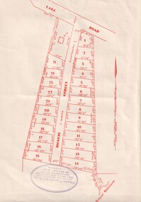 Whitehorse Historical Society Inc.
Document, Dickens Street, Blackburn
... Auction of housing development in Dickens Street, Blackburn, comprising 25 sites, leading off Lake Road. ...Whitehorse Historical Society Inc. 2-10 Deep Creek Road Mitcham melbourne Consult also ND3749 which sates the existence of gold mining in the area until 1880. dickens street blackburn frank fisher co. lake road Auction of housing development in Dickens Street, Blackburn, comprising 25 sites, leading off Lake Road. ...Auction of housing development in Dickens Street, Blackburn, comprising 25 sites, leading off Lake Road. Agent Frank Fisher & Co.dickens street, blackburn, frank fisher co., lake road -
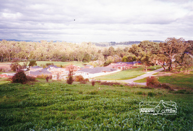 Eltham District Historical Society Inc
Photograph, View from Porter Street, Eltham to south east, c.1994, 1994c
... Colour photograph of view southeast from Porter Street, Eltham c.1994 showing new housing development on Riverview Estate formerly Fabbro farm....Eltham District Historical Society Inc 728 Main Rd Eltham melbourne porter street eltham riverview estate m fabbro Colour photograph of view southeast from Porter Street, Eltham c.1994 showing new housing development on Riverview Estate formerly Fabbro farm. ...Colour photograph of view southeast from Porter Street, Eltham c.1994 showing new housing development on Riverview Estate formerly Fabbro farm.porter street, eltham, riverview estate, m fabbro -
 Ballarat Heritage Services
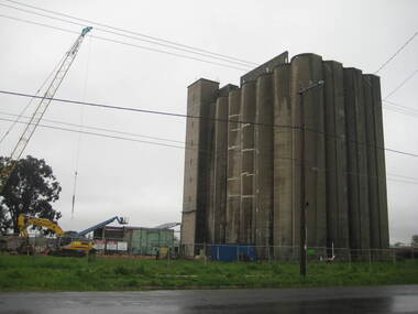
Photograph - Photograph - Colour, Lisa Gervasoni, Joe White Maltings Silos Under Demolition, 2010, 15/10/2010
... Joe White Maltings Silos in Gregory Street Ballarat under demolition, to make way for a housing development. The silos were built on the banks of Lake Wendouree. ...(Ballarat Courier, 03 August 2010) joe white maltings silo eleveno pty ltd lake wendouree demolition gregory street ballarat wendouree parade architecture Joe White Maltings Silos in Gregory Street Ballarat under demolition, to make way for a housing development. The silos were built on the banks of Lake Wendouree. ..."A plan to turn the Gregory Street silos into apartments is no more.Developers Eleveno Pty Ltd have abandoned plans to transform the Lake Wendouree silos into a giant apartment complex, despite previously being given the green light from the Victorian Civil and Administrative Tribunal.Director Richard Sykes yesterday confirmed the silos would be demolished."The plans are not proceeding. The plan now is to create residential houses," he said.The planning permit for an 18-lot subdivision was approved by Ballarat City Council on July 22, despite objections lodged against the application.Mr Sykes said it wasn't feasible to turn the silos into 27 units and there were many factors behind the decision."They're being demolished for various reasons, there were just better solutions," he said.Bold plans to transform the former Joe White Maltings silos into apartments were first submitted to Ballarat City Council in January 2007.However, developers took the proposal to VCAT in September 2008 after council failed to make a decision in the required 60-day timeframe.A hearing was held in early 2009 and the development was approved in March last year.Mr Sykes said it was found that the building would most likely be out of place in the region."We found the market didn't really want that sort of development," he said."They're probably more suited for inner-city development, rather than regional areas."Mr Sykes did not put a price on either the proposed development or the demolition, but said it would "cost a fair amount of money".He said once the demolition permit has been passed, works were expected to begin in November." (Ballarat Courier, 03 August 2010)Joe White Maltings Silos in Gregory Street Ballarat under demolition, to make way for a housing development. The silos were built on the banks of Lake Wendouree. joe white maltings, silo, eleveno pty ltd, lake wendouree, demolition, gregory street ballarat, wendouree parade, architecture -
 Ringwood and District Historical Society
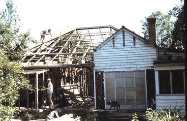
Photograph, Frazer's orchard 'Alkoomi' North Ringwood - Farm house demolition c1971
... Jennings for housing development. Circa 1971...Jennings for housing development. Circa 1971 Frazer's orchard 'Alkoomi' North Ringwood - Farm house demolition c1971 Photograph ...Harold Frazer’s “Alkoomi” orchard farm house, Oban Rd Nth Ringwood, undergoing demolition after land was sold to A.V. Jennings for housing development. Circa 1971