Showing 9 items matching "hughes avenue"
-
 Port Fairy Historical Society Museum and Archives
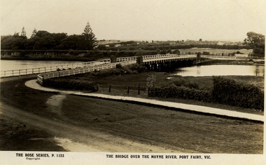
Postcard, The Rose Series / The Rose Stereographs, The Bridge over Moyne River, Port Fairy Vic
... ...hughes avenue...Black and white Photograph of the Moyne river road bridge with the botanical gardens in the left background and some huts built possibly on Hughes Avenue...Port Fairy Historical Society Museum and Archives 30 Gipps Street Port Fairy great-ocean-road moyne bridge hughes avenue gipps street river dunes botanical gardens The Rose Series P.1123 copyright.- The Bridge over the Moyne River Port Fairy Vic. ...Black and white Photograph of the Moyne river road bridge with the botanical gardens in the left background and some huts built possibly on Hughes AvenueThe Rose Series P.1123 copyright.- The Bridge over the Moyne River Port Fairy Vic.moyne bridge, hughes avenue, gipps street, river, dunes, botanical gardens -
 Port Fairy Historical Society Museum and Archives
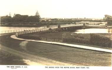
Postcard, The Rose Series / The Rose Stereographs, The Bridge over Moyne River, Port Fairy Vic
... Black and white Photograph of the bridge over the Moyne river with the Botanical Gardens on the left in the background and also some huts on Hughes Avenue in the background...Black and white Photograph of the bridge over the Moyne river with the Botanical Gardens on the left in the background and also some huts on Hughes Avenue in the background The Bridge over Moyne River, Port Fairy Vic. ...Black and white Photograph of the bridge over the Moyne river with the Botanical Gardens on the left in the background and also some huts on Hughes Avenue in the backgroundThe Rose Series P. 1123 copyright- The Bridge over the Moyne River Port Fairy Vic.moyne bridge circa 1930, moyne river, bridge, river, botanical gardens -
 City of Kingston
Photograph - Colour, Circa 1993
... The Golf Links Court residential development located off Hughes Avenue is a large vacant block....The Golf Links Court residential development located off Hughes Avenue is a large vacant block. Photograph Colour ...Edithvale is a suburb in the City of Kingston. It is located between Aspendale and Chelsea on the Port Phillip Bay and built within remnant areas of the Carrum Carrum swamp. The foreshore precinct comprises a wide sandy beach, with low sand dunes and numerous historic boat sheds. The suburb consists of older style dwellings and former holiday houses, combined with mid-century housing and newer homes. The large blocks are increasingly subdivided and the existing dwellings demolished to accommodate units and townhouses, thus changing the landscape of the area and reducing the tree canopy.The beachside suburb of Edithvale was previously part of the extensive Carrum Carrum Swamp. The area was once a source of fish and eels for the Mayone-Bulluk clan of the Bunurong people. Over time the area was drained and predominantly devoted to dairy farming and holiday houses. The farms were gradually sold and subdivided with a large number of homes built after World War II and in the 1960s. Edithvale is mainly residential with a shopping strip along Nepean Highway but little significant industry was ever established in the area apart from a plaster works and confectionary factory, both now closed.Aerial colour photograph of Edithvale as viewed from Alexandra Avenue in the north to Ella Grove Chelsea/Edithvale in the south. The area is built-up with residential housing and facilities including Edithvale Primary School, numerous churches and the Edithvale Railway station. Large sections depict the remnant Carrum Carrum swamp. Edithvale Common and the former "Duck Inn" (Melbourne Water/Friends of Edithvale Seaford Wetlands) can be seen. Edithvale Recreational reserve, the velodrome and Edithvale Public Golf Course are prominent. The image shows vacant land in the area now known as Aspendale Gardens and the newer residential section of Chelsea Heights is not developed. A bike path has been established to cover the secondary drain. The Golf Links Court residential development located off Hughes Avenue is a large vacant block.Yellow circular adhesive sticker on plastic Black ink (marker): * (asterisk) Black type on white adhesive sticker: P000108edithvale, aspendale, chelsea, carrum carrum swamp -
City of Kingston
Photograph - Colour, 6 March 1993
... The Golf Links Court residential development located off Hughes Avenue is a large vacant block....The Golf Links Court residential development located off Hughes Avenue is a large vacant block. Photograph Colour ...Edithvale is a suburb in the City of Kingston. It is located between Aspendale and Chelsea on the Port Phillip Bay and built within remnant areas of the Carrum Carrum swamp. The foreshore precinct comprises a wide sandy beach, with low sand dunes and numerous historic boat sheds. The suburb consists of older style dwellings and former holiday houses, combined with mid-century housing and newer homes. The large blocks are increasingly subdivided and the existing dwellings demolished to accommodate units and townhouses, thus changing the landscape of the area and reducing the tree canopy.The beachside suburb of Edithvale was previously part of the extensive Carrum Carrum Swamp. The area was once a source of fish and eels for the Mayone-Bulluk clan of the Bunurong people. Over time the area was drained and predominantly devoted to dairy farming and holiday houses. The farms were gradually sold and subdivided with a large number of homes built after World War II and in the 1960s. Edithvale is mainly residential with a shopping strip along Nepean Highway but little significant industry was ever established in the area apart from a plaster works and confectionary factory, both now closed.Laminated aerial colour photograph of Edithvale as viewed from Alexandra Avenue in the north to Ella Grove Chelsea/Edithvale in the south. regents Park Aspendale can be seen in the top left. The area is built-up with residential housing and facilities including Edithvale Primary School, numerous churches and the Edithvale Railway station. Large sections depict the remnant Carrum Carrum swamp. Edithvale Common and the former "Duck Inn" (Melbourne Water/Friends of Edithvale Seaford Wetlands) can be seen. Edithvale Recreational reserve, the valodrome and Edithvale Public Golf Course are prominent. The image shows vacant land in the area now known as Aspendale Gardens and the newer residential section of Chelsea Heights is not developed. A bike path has been established to cover the secondary drain. The Golf Links Court residential development located off Hughes Avenue is a large vacant block.Black type on white adhesive label: 6-3-93 Black type on white adhesive label: 25/9211, 6/3/93, 11.20 am Black type on white adhesive label: 9211 Yellow circular adhesive sticker Black pencil: 9211 6-3-93 arrow pointing Nedthvale, carrum carrum swamp, aspendale, chelsea -
 Eltham District Historical Society Inc
Album - Document, J.A. McDonald, Report to Works Committee: Garbage Disposal, Eltham and Montmorency Ridings, c. 1956
... Avenue...Report...Road construction...Shire Engineer...Skyline Theatre...Tips...W.U. Hughes...McDonald Montmorency Park Panorama Avenue Report Road construction Shire Engineer Skyline Theatre Tips W.U. Hughes Works Committee: Garbage Disposal Six typed foolscap pages Inserted in an album of 78 foolscap pages containing a sequence of photos, adhered via glue or sticky tape, with typed or handwritten headings and captions in pencil. ...Reference report associated with photos: EDHS_05569-30-4 Box Hill Tip EDHS_05569-30-6 Camberwell Tip EDHS_05569-30-7 Camberwell Tip EDHS_05569-30-8 Camberwell TipRecord of various Shire of Eltham infrastructure works undertaken during the period of 1952-1962 involving bridge and road reconstruction projects, sometimes with Eltham Shire Council Project Reference numbers quoted. It was during this period that a number of significant improvements were made to roads and new bridges constructed within the shire that remain in place as of present day (2022). In many situations, the photos provide a tangible visible record of infrastructure that existed throughout the early days of the Shire. The album was put together by or under the direction of the Shire Engineer, J.A. McDonald.infrastructure, shire of eltham, benchmark studies, box hill state school, box hill teachers college, box hill tip, andrew park, camberwell city council tip, eltham lower park, eltham tip, health inspector, heidelberg city tip, j.a. mcdonald, montmorency park, panorama avenue, report, road construction, shire engineer, skyline theatre, tips, w.u. hughes, works committee: garbage disposal -
Glen Eira Historical Society
Letter - HUNT, WILLIAM HOGARTH
... Hughes Body works... Chemists... Davidson’s... Glenhuntly Printing... Hay and corn stores... Railway Gates... ANZ Bank... Fox Mr... Martin Jack... Fox Mrs... Clothing Stores... Steam rollers... Radio and TV Shop... Beasley J... Delicatessen/ham and beef shop... Butchers... Schurme’s Private Hospital... Gellatley George... Tailors... Commonwealth Banks... Watson Grove... Banks... Preston Peter... E.J. & H. Amos... Hardware stores... Estate Agents... Glenhuntly Picture Theatre... Whittle Mr... Theatres... Newsagency... Cooper and Cooke... Station Street... F.J. Long and Co... Jennings A.V... Timber yards... Builders... ‘The Estate’... Hillcrest Estate... Grange Road... Marara Road... Rosedale Avenue...Personal memories Hunt William Hogarth Glenhuntly Grange Road Trams Plumber Stone Mary Ann Neerim Road Wanalta Road Schurme Mrs Private Hospital Hospitals Watson Grove Hunt Jessie Hunt Alfred Hunt Charles Smith Mr Fisher Mr Smith Mrs Jockeys Dore George ‘Willis’ Builders House names Mernda Roseberry Grove El Nido Neerim Road Glenhuntly Post Office Mrs Fielder’s sweetshop Mrs Beer’s sweet shop Paddocks Confectionery Fielder Fred Maroona Road Murrumbeena Grocers Callister Dave Carnegie State School Hay and corn store James Street Woodyard Hillards chemist Hughes Body works Chemists Davidson’s Glenhuntly Printing Hay and corn stores Railway Gates ANZ Bank Fox Mr Martin Jack Fox Mrs Clothing Stores Steam rollers Radio and TV Shop Beasley J Delicatessen/ham and beef shop Butchers Schurme’s Private Hospital Gellatley George Tailors Commonwealth Banks Watson Grove Banks Preston Peter E.J. & H. Amos Hardware stores Estate Agents Glenhuntly Picture Theatre Whittle Mr Theatres Newsagency Cooper and Cooke Station Street F.J. Long and Co Jennings A.V Timber yards Builders ‘The Estate’ Hillcrest Estate Grange Road Marara Road Rosedale Avenue ...Two sets of this man's handwritten memories: 1/Five pages of handwritten personal memories, written by William Hogarth Hunt 13/07/1977. He outlines his family, their travels and settlement in 1908 at Glenhuntly: a detailed account of residents, shop owners, land sales and identities, Murray Ross, Mr Burr of Burr’s Gun Oil and Mr Zarman. Also details Glenhuntly Methodist Church, football, athletics, Glenhuntly Aerodrome and an extensive list of local residents and their stories. 2/Two pages of handwritten personal memories, written by William Hogarth Hunt 02/09/1977. A detailed account of residents, shop owners, identities, athletes, local policemen and their stories in the Glen Huntly area.personal memories, hunt william hogarth, glenhuntly, grange road, trams, plumber, stone mary ann, neerim road, wanalta road, schurme mrs, private hospital, hospitals, watson grove, hunt jessie, hunt alfred, hunt charles, smith mr, fisher mr, smith mrs, jockeys, dore george, ‘willis’, builders, house names, mernda, roseberry grove, el nido, neerim road, glenhuntly post office, mrs fielder’s sweetshop, mrs beer’s sweet shop, paddocks, confectionery, fielder fred, maroona road, murrumbeena, grocers, callister dave, carnegie state school, hay and corn store, james street, woodyard, hillards chemist, hughes body works, chemists, davidson’s, glenhuntly printing, hay and corn stores, railway gates, anz bank, fox mr, martin jack, fox mrs, clothing stores, steam rollers, radio and tv shop, beasley j, delicatessen/ham and beef shop, butchers, schurme’s private hospital, gellatley george, tailors, commonwealth banks, watson grove, banks, preston peter, e.j. & h. amos, hardware stores, estate agents, glenhuntly picture theatre, whittle mr, theatres, newsagency, cooper and cooke, station street, f.j. long and co, jennings a.v, timber yards, builders, ‘the estate’, hillcrest estate, grange road, marara road, rosedale avenue, hobart jack, mackie road, confectionery stores, ross murray, glenhuntly athletic club, godfrey evelyn, athletics clubs, railways, glenhuntly junior football club, elsternwick, princess park, carnegie oval, booran road, koornang park, ormond oval – ee. gunn reserve, glenhuntly oval, oakleigh road, victorian amateur turf club, koornang road, glenhuntly aerodrome, neville street, glenhuntly state school, rosslyn street, geary mr, lauriston tennis courts, bakers, carnegie r.s.l., east bentleigh, bowling clubs, tucker road, tennis clubs, centre road, murrumbeena road, larman mr, hollway street, nurseries, parker street, lyle marshall, burr mr, solicitors, builders, bones nursery, ‘burr’s gunoil’, glenhuntly methodist church, carnegie, smith alf, ezard family, clemens family, noy family, noy clarrie, dickie family, storey family, storey george, davis family, joss house, chinese community, wattle avenue, grange road, glenhuntly amateur football club, football clubs, glenhuntly athletic club, athletic clubs, glen huntly junior football club, carnegie oval, koornang park, glenhuntly oval, victorian amateur turf club, glenhuntly aerodome, glenhuntly state school, geary mr., bakers, east bentleigh, tucker road, centre road, larman mr, nurseries, lyle marshall, solicitors, bones nursery, carnegie, "the estate", royal avenue, mckay avenue, dumsday bertha miss, love family, gilmour family, waratah ave, sinclair mr, tuckpointers, bricks, donegan mr, plumbers, frazer mr, frazer and jenkinson printers, frazer arthur, ezard manufacturing, jewellers, private hospital, maroona road, o'carroll mr, beattie mr, horse trainer, morton tom, lord harry, estate agents, ormond, councillors, taylor mr, builders, gibson family, westley alf, o'carroll j (jack) d, glenhuntly athletics club, athletes, jack page's bakery and cake shop, nay clarrie, hunt william h., hunt alf, page jack, armstrong jack, manchester grove, morgan advertising, cusdin sid, farrier, glenhuntly cricket club, caulfield racecourse, neerim road, hoffman's plumbing, emma street, st. agnes school, st. agnes church hall, jenkin 'boss' mr, teachers, hawthorn miss, quinn miss, chitty charlie, chitty's timber, crystal palace picture theatre, theatres, marsh bill, hardware shops, watson arthur w, j.s. kidd and company, marshes hardware, kidd's hardware, bruce ivy, 'belgrave', house names, belgrave road, dandenong road, hunter 'pud', police officers, hunt jess, kangaroo road, murrumbeena, glen huntly -
 City of Ballarat
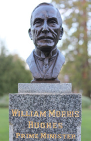
Artwork, other - Public Artwork, Wallace Anderson, William Morris Hughes (Prime Ministers' Walk) by Wallace Anderson, c1940
... Hughes’ record term from 1915 to 1923. A long standing parliamentarian of 51 years and 7 months continuous service as a member of Australia’s House of Representatives – from the 1st parliament in 1901 to the 20th in 1952. The Prime Ministers Avenue...Hughes’ record term from 1915 to 1923. A long standing parliamentarian of 51 years and 7 months continuous service as a member of Australia’s House of Representatives – from the 1st parliament in 1901 to the 20th in 1952. The Prime Ministers Avenue ...William Morris Hughes, Australia’s 7th and longest serving Prime Minister until 1957 when Robert Menzies overtook Hughes’ record term from 1915 to 1923. A long standing parliamentarian of 51 years and 7 months continuous service as a member of Australia’s House of Representatives – from the 1st parliament in 1901 to the 20th in 1952. The Prime Ministers Avenue is a collection of bronze bust portraits of the Prime Ministers of Australia, located at the Ballarat Botanical Gardens in Ballarat, Victoria. The Prime Ministers' portraits are commissioned after the incumbent term of each Prime Minister by the City of Ballarat. The City of Ballarat has taken responsibility for commissioning the busts after funds set aside by politician Richard Armstrong Crouch were exhausted in 2014. Crouch originally donate money to pay for six busts, the first of which was unveiled in 1940. The collection of prime ministers' busts are unique in Australia, representing the only sculptural portrait collection of all past Australian Prime Ministers. The different styles used reflect the unique artistic practices of the selected artists; textures, sizes and features and proportions are used by the artists to interpret the characteristics of each of the subjects.The artwork is of historic and aesthetic significance to the people of Ballarat Bronze bust cast on granite plinthWilliam Morris Hughes Prime Minister 1915-23prime minister, australian pm, william morris hughes, parliament -
 Kew Historical Society Inc
Album - Scrapbook, Eva Grant, Historic Buildings, Kew, 1958-78, 1970s
... hughes' house - 167 cotham road...congregational church - walpole street - kew...country roads board - denmark street - kew...dorothy rogers reserve - studley park road - kew...field place - 3 henty court - kew (vic)...ellsmere (also ellesmere/ellsmore) - princess street - kew...fernhurst - 13 fernhurst grove - kew (vic)...kew civic centre - civic drive - kew (vic)...kew junction - kew (vic)...kew railway station - denmark street - kew (vic)...recreation hall - wellington street - kew...neama - hall - studley park road - kew (vic)...southesk - ordsall - cotham road- kew (vic)...st anthony's home for babies - madford - 43 wellington street (vic)...studley house - nolan avenue...Buildings included in the scrapbook include: Billy Hughes' house - 167 Cotham Road Congregational Church - Walpole Street (c.1978) Country Roads Board - Denmark Street (1960) Dorothy Rogers Reserve - Studley Park Road Ellsmere (also Ellesmere/Ellsmore) - Princess Street Field Place - 3 Henty Court Fernhurst - 13 Fernhurst Grove Kew Civic Centre (1959) Kew Junction (1958) Kew Railway Station (1902, 1959) Kew Recreation Hall - Wellington Street (1960) Neama (Hall) - Studley Park Road Southesk (formerly Ordsall) - Cotham Road (c.1960) St Anthony's Home for Babies (formerly Madford) - 43 Wellington Street (c.1976) Studley House - Nolan Avenue...Buildings included in the scrapbook include: Billy Hughes' house - 167 Cotham Road Congregational Church - Walpole Street (c.1978) Country Roads Board - Denmark Street (1960) Dorothy Rogers Reserve - Studley Park Road Ellsmere (also Ellesmere/Ellsmore) - Princess Street Field Place - 3 Henty Court Fernhurst - 13 Fernhurst Grove Kew Civic Centre (1959) Kew Junction (1958) Kew Railway Station (1902, 1959) Kew Recreation Hall - Wellington Street (1960) Neama (Hall) - Studley Park Road Southesk (formerly Ordsall) - Cotham Road (c.1960) St Anthony's Home for Babies (formerly Madford) - 43 Wellington Street (c.1976) Studley House - Nolan Avenue The scrapbook contains historically significant, rare and sometimes unique images of significant heritage buildings in Kew, including their erection and demolition. eva grant billy hughes' house - 167 cotham road congregational church - walpole street - kew country roads board - denmark street - kew dorothy rogers reserve - studley park road - kew field place - 3 henty court - kew (vic) ellsmere (also ellesmere/ellsmore) - princess street - kew fernhurst - 13 fernhurst grove - kew (vic) kew civic centre - civic drive - kew (vic) kew junction - kew (vic) kew railway station - denmark street - kew (vic) recreation hall - wellington street - kew neama - hall - studley park road - kew (vic) southesk - ordsall - cotham road- kew (vic) st anthony's home for babies - madford - 43 wellington street (vic) studley house - nolan avenue - kew (vic) Includes letter from donor 11-page scrapbook of photographs and newspaper clippings with annotations by Eva Grant, a past member of the Kew Historical Society. ...One of three scrapbooks of photographs and newspaper cuttings taken and or collected by Eva Grant, a past member of the Kew Historical Society, which were donated by her niece, Julie Thomson. The albums include many photographs of Kew from the 1950s to the 1970s. Buildings included in the scrapbook include: Billy Hughes' house - 167 Cotham Road Congregational Church - Walpole Street (c.1978) Country Roads Board - Denmark Street (1960) Dorothy Rogers Reserve - Studley Park Road Ellsmere (also Ellesmere/Ellsmore) - Princess Street Field Place - 3 Henty Court Fernhurst - 13 Fernhurst Grove Kew Civic Centre (1959) Kew Junction (1958) Kew Railway Station (1902, 1959) Kew Recreation Hall - Wellington Street (1960) Neama (Hall) - Studley Park Road Southesk (formerly Ordsall) - Cotham Road (c.1960) St Anthony's Home for Babies (formerly Madford) - 43 Wellington Street (c.1976) Studley House - Nolan AvenueThe scrapbook contains historically significant, rare and sometimes unique images of significant heritage buildings in Kew, including their erection and demolition. 11-page scrapbook of photographs and newspaper clippings with annotations by Eva Grant, a past member of the Kew Historical Society. The pages of the album can be viewed in the image carousel above. Based on the text and known dates of demolition of a number of the buildings, the scrapbook was assembled over a twenty year period between c.1958-c.1978.Includes letter from donoreva grant, billy hughes' house - 167 cotham road, congregational church - walpole street - kew, country roads board - denmark street - kew, dorothy rogers reserve - studley park road - kew, field place - 3 henty court - kew (vic), ellsmere (also ellesmere/ellsmore) - princess street - kew, fernhurst - 13 fernhurst grove - kew (vic), kew civic centre - civic drive - kew (vic), kew junction - kew (vic), kew railway station - denmark street - kew (vic), recreation hall - wellington street - kew, neama - hall - studley park road - kew (vic), southesk - ordsall - cotham road- kew (vic), st anthony's home for babies - madford - 43 wellington street (vic), studley house - nolan avenue - kew (vic) -
 Mt Dandenong & District Historical Society Inc.
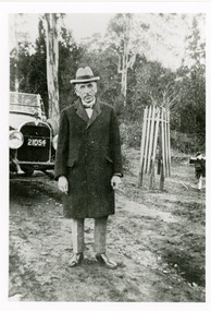
Photograph, Billy Hughes at Sassafras
... The Prince of Wales made an unofficial visit in 1920 and stayed with Billy Hughes in his holiday home. The Prince of Wales planted a tree in Anzac Avenue that had been officially opened on April 14th, 1920 by Captain Stanley Melbourne Bruce, who became Prime Minister after Billy Hughes....The Prince of Wales made an unofficial visit in 1920 and stayed with Billy Hughes in his holiday home. The Prince of Wales planted a tree in Anzac Avenue that had been officially opened on April 14th, 1920 by Captain Stanley Melbourne Bruce, who became Prime Minister after Billy Hughes. billy hughes w m hughes sassafras prime minister Black and white photograph showing well dressed man standing in front of a car . ...Copy of a photograph of Mr W M (Billy) Hughes, the Australian Prime Minister from 1915 to 1923 in the Main Street of Sassafras. Billy Hughes had a holiday house called Ty-Coed in Clarkmont Road. The Prince of Wales made an unofficial visit in 1920 and stayed with Billy Hughes in his holiday home. The Prince of Wales planted a tree in Anzac Avenue that had been officially opened on April 14th, 1920 by Captain Stanley Melbourne Bruce, who became Prime Minister after Billy Hughes.Black and white photograph showing well dressed man standing in front of a car .billy hughes, w m hughes, sassafras, prime minister