Showing 17 items matching "hume highway victoria"
-
 Wodonga & District Historical Society Inc
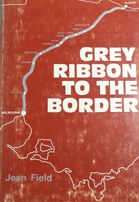
Book - Grey Ribbon to the Border, Jean Field, 1973
... ...hume highway victoria...Wodonga & District Historical Society Inc Hut 97, Bonegilla Migrant Experience, 132 Bonegilla Road Bonegilla the-murray victoria. countryside adjacent to the hume highway. description and travel victoria hume highway victoria A detailed description of towns and area adjacent to the Hume Highway between Melbourne, Victoria and Albury, NSW Grey Ribbon to the Border Book Grey Ribbon to the Border Jean Field ...A detailed description of towns and area adjacent to the Hume Highway between Melbourne, Victoria and Albury, NSWnon-fictionA detailed description of towns and area adjacent to the Hume Highway between Melbourne, Victoria and Albury, NSWvictoria. countryside adjacent to the hume highway., description and travel victoria, hume highway victoria -
 Whitehorse Historical Society Inc.
Book, Grey ribbon to the border, 1973
... hume highway...victoria...Whitehorse Historical Society Inc. 2-10 Deep Creek Road Mitcham melbourne hume highway victoria History of the Hume Highway History of the Hume Highway Grey ribbon to the border Book Book ...History of the Hume HighwayHistory of the Hume HighwayHistory of the Hume Highwayhume highway, victoria -
 Wodonga & District Historical Society Inc
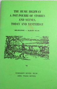
Book - The Hume Highway: A Potpourri of Stories and Scenes Today and Yesterday, Rosemary Boyes, 1978
... hume highway...travel victoria...Wodonga & District Historical Society Inc Hut 97, Bonegilla Migrant Experience, 132 Bonegilla Road Bonegilla the-murray albury melbourne hume highway travel victoria anecdotes and pioneer stories A collection of anecdotes from travel along the Hume Highway from Melbourne, Victoria to Albury, NSW. ...A collection of anecdotes from travel along the Hume Highway from Melbourne, Victoria to Albury, NSW.non-fictionA collection of anecdotes from travel along the Hume Highway from Melbourne, Victoria to Albury, NSW.albury, melbourne, hume highway, travel victoria, anecdotes and pioneer stories -
 Greensborough Historical Society
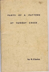
Booklet, Ruth Clarke, Parts of a pattern at Sunday Creek, 1971
... Historical notes on the community of Sunday Creek, south of Broadford off the Hume Highway in Victoria...Greensborough Historical Society 34A Glenauburn Road Lower Plenty Lower Plenty melbourne Historical notes on the community of Sunday Creek, south of Broadford off the Hume Highway in Victoria sunday creek victoria broadford 45 p., black and white illustrations Parts of a pattern at Sunday Creek Booklet Booklet Ruth Clarke Ajax Printing & Duplicating Pty Ltd ...Historical notes on the community of Sunday Creek, south of Broadford off the Hume Highway in Victoria45 p., black and white illustrationssunday creek, victoria, broadford -
 Orbost & District Historical Society
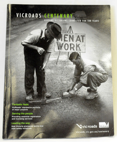
book, Vic Roads Centenary 1913 -2013, 2013
... Written by current and former VicRoads’ employees, the publication details the organisation’s portfolio of major projects, which includes the Great Ocean Road, Hume Highway and Eastern Freeway. Other sections report on Victoria’s world-first road safety initiatives, VicRoads’ use of technology and sustainability measures. ...Written by current and former VicRoads’ employees, the publication details the organisation’s portfolio of major projects, which includes the Great Ocean Road, Hume Highway and Eastern Freeway. Other sections report on Victoria’s world-first road safety initiatives, VicRoads’ use of technology and sustainability measures. ...The publication, VicRoads Centenary: Keeping Victorians Connected for 100 Years, looks at the people and projects that define VicRoads’ history. Written by current and former VicRoads’ employees, the publication details the organisation’s portfolio of major projects, which includes the Great Ocean Road, Hume Highway and Eastern Freeway. Other sections report on Victoria’s world-first road safety initiatives, VicRoads’ use of technology and sustainability measures. (ref VicRoads) This item is one of several books donated by David Jellie at a presentation to Orbost Historical Society. He was a contributor to the book and was the engineer for the Snowy River Bridge (Princes Highway) at Orbost 1974-1976.This book is a useful reference tool on the history of road construction in Victoria including East Gippsland.A thick, bound paperback book, titled "VicRoads Centenary Keeping Victorians Connected for 100 Years". On the front cover is a black/white photograph of two men working on a road. One has a pick. The book contains the history of VicRoads, photographs, maps and advertisements. Some are b/w. Others are coloured.vicroads book roads snowy-river-bridge jellie-david -
 Greensborough Historical Society
Map, Australia. Department of Minerals and Energy, Melbourne, topographic map, 1970_
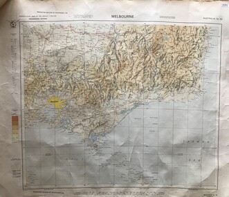
... Victoria with Melbourne as the centre. Provisional edition showing contours in feet. International map of the world [scale] 1:1,000,000. Prepared by the Department of Minerals and Energy, Canberra in 1970. A pre-metric map, shows the Hume Highway ...A topographic map of Victoria with Melbourne as the centre. Provisional edition showing contours in feet. International map of the world [scale] 1:1,000,000. Prepared by the Department of Minerals and Energy, Canberra in 1970.A pre-metric map, shows the Hume Highway travelling through towns such as Seymour and Benalla, now by-passed by the Hume Freeway.Map, printed in colour on one side.victoria - maps -
 Broadmeadows Historical Society & Museum
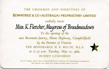
Ephemera - Invitation, Rowntree & Co. (Australia) Proprietary Limited, Invitation to opening of new Rowntree factory, Campbellfield, 1964
... Fletcher, Mayoress of Broadmeadows / To the opening of the / new Rowntree factory, Hume Highway, Campbellfield / by the Premier of Victoria / THE HONORABLE H. ...Victoria / THE HONORABLE H. E. BOLTE, M.L.A. / at 11.15 a.m. Tuesday, May 12, 1964. / BUFFET LUNCHEON” (lower margin): “R.S.V.P. Monday, April 27, Mrs. D. Youel, Rowntree & Co. (Aust) Pty. Ltd., Hume Highway ...The invitation documents the opening of Rowntree & Co. (Australia)’s Campbellfield factory in 1964, officiated by the Premier of Victoria. It demonstrates post‑war industrial expansion in Melbourne’s northern suburbs and highlights civic–corporate relationships through the invitation of the local Mayoress.This item has local historic significance for Broadmeadows and Campbellfield, providing primary evidence of major industrial development and civic engagement in Victoria during the 1960s.Rectangular printed card with rounded corners. Cream/light buff cardstock. Recto printed in gold and black ink; verso blank except for later applied catalogue label.Recto (centre): “THE CHAIRMAN AND DIRECTORS OF / ROWNTREE & CO (AUSTRALIA) PROPRIETARY LIMITED / cordially invite / Miss K. Fletcher, Mayoress of Broadmeadows / To the opening of the / new Rowntree factory, Hume Highway, Campbellfield / by the Premier of Victoria / THE HONORABLE H. E. BOLTE, M.L.A. / at 11.15 a.m. Tuesday, May 12, 1964. / BUFFET LUNCHEON” (lower margin): “R.S.V.P. Monday, April 27, Mrs. D. Youel, Rowntree & Co. (Aust) Pty. Ltd., Hume Highway, Campbellfield. / This Invitation is your Entree Card. Would you kindly present it on arrival.” Recto (right): Gold star motif Verso (upper right): “WI 4054” (typed label)industrial development, campbellfield (vic.), broadmeadows (vic.), corporate events, manufacturing history, local government representation -
Broadmeadows Historical Society & Museum
Photograph - Aerial Photograph
... The photograph is historically significant as it reflects the broader patterns of post-2000 suburban growth in Victoria, driven by population pressures, housing demand, and strategic planning initiatives. It provides insight into land use changes, transport connectivity (notably the Hume Highway and Craigieburn railway line), and the emergence of community hubs such as Craigieburn Central. ...Craigieburn is a rapidly growing suburb located approximately 25 km north of Melbourne’s CBD. Historically, it was a rural area with agricultural roots, but since the late 20th century, it has undergone significant urban development. The transformation accelerated in the 1990s and 2000s, with large-scale residential subdivisions, infrastructure projects, and commercial developments reshaping the landscape. Key historical milestones include: Early Settlement: Originally inhabited by the Wurundjeri people of the Kulin Nation. European Settlement: Began in the mid-1800s, primarily for farming and grazing. Urban Expansion: Post-1970s, Craigieburn saw increasing suburban development, especially after the extension of rail and road infrastructure. Recent Growth: From the 2000s onward, Craigieburn became one of Melbourne’s fastest-growing suburbs, with new estates, schools, and shopping centres.This large colour aerial photograph of Craigieburn holds significant value as a visual record of the suburb’s transformation from a semi-rural landscape to a dynamic urban centre in Melbourne’s northern growth corridor. Captured during a period of rapid development, the image documents the spatial evolution of Craigieburn, including residential expansion, infrastructure projects, and the integration of green spaces and commercial zones. The photograph is historically significant as it reflects the broader patterns of post-2000 suburban growth in Victoria, driven by population pressures, housing demand, and strategic planning initiatives. It provides insight into land use changes, transport connectivity (notably the Hume Highway and Craigieburn railway line), and the emergence of community hubs such as Craigieburn Central. From a cultural heritage perspective, the image contributes to understanding the lived environment of diverse communities who have settled in Craigieburn, including its role in accommodating Melbourne’s multicultural population. It also serves as a reference point for future urban planning, environmental monitoring, and historical comparison. The photograph is an important archival asset for researchers, planners, and local historians, offering a detailed snapshot of a pivotal moment in Craigieburn’s development trajectory.Colour aerial photograph of Craigieburnaerial photograph, craigieburn -
 Hume City Civic Collection
Photograph, c 1993
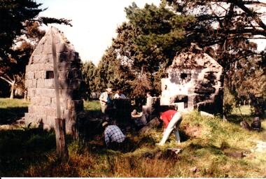
... Hume City Civic Collection 44 Macedon Street Sunbury melbourne Aitkens Gap Police Lock up was originally constructed at The Gap which was south of the junction of Gap Road (Sunbury Road) and Calder Highway (Victoria St/Mt. ...Aitkens Gap Police Lock up was originally constructed at The Gap which was south of the junction of Gap Road (Sunbury Road) and Calder Highway (Victoria St/Mt. Alexander Road). It was part of a police complex which was a changeover station for the gaol escort. The goal was relocated and rebuilt in the police station grounds in Sunbury in 1993.A coloured photograph of five men working on the removal of Aitkens Gap Gaol from its original site. Two end walls of the gaol are standing and the work is being done on the front and back of the building. Conifers and cypress trees are growing around the site.peter free, aitkens gap gaol, police historical association, sunbury police station, george evans collection -
 Wodonga & District Historical Society Inc
Booklet - Sarah Coventry Affinity Range Catalogue 1982
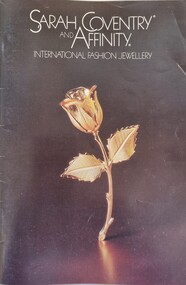
... Victoria, as well as national and international significance from the perspective of social and economic developments for women after World War II. The direct selling party-plan business model Sarah Coventry was based on is also considered the first of its kind for jewellery. Sarah Coventry Sarah Coventry Wodonga Sarah Coventry Affinity A coloured catalogue promoting the Affinity Jewellery line released in 1982. The back cover features a fundraising campaign for the Guide Dog Association. Business contact details on the back cover use the company name "Sar*Gem Pty Ltd", Hume Highway ...Historical information Sarah Coventry Pty. Ltd. was a North American jewellery company that was established in 1949 by the Stuart family as part of Emmons Jewelry, Inc. It began operations in England and Australia in 1968, and in Australia it moved from Carlton in Melbourne to Wodonga in 1969. The premises were originally on High Street in Wodonga, but a new warehouse was built in Melbourne Road later in 1969. It was a direct selling jewellery business using a party-plan model similar to Tupperware and Avon. The sales reps or 'Hostesses' were provided with jewellery samples in demonstration kits, which they displayed at jewellery parties in their homes. The designs for jewellery such as brooches, necklaces, earrings, chokers and bracelets were purchased from freelance designers and jewellery manufacturers rather than in-house designers. In 1979 Sarah Coventry Pty. Ltd. in Wodonga was bought by three Australian businessmen, including Wodonga local Jim Sawyer, and continued to sell jewellery under the name "Sar*gem Pty. Ltd”, for several more years in the 1980s, along with a new range of fashion jewellery, Affinity. This catalogue was produced by Sar*gem Pty Ltd in 1982As part of the Sarah Coventry collection, the catalogue has local significance connected to the decentralised commercial development of regional centres such as Wodonga in NE Victoria, as well as national and international significance from the perspective of social and economic developments for women after World War II. The direct selling party-plan business model Sarah Coventry was based on is also considered the first of its kind for jewellery. A coloured catalogue promoting the Affinity Jewellery line released in 1982. The back cover features a fundraising campaign for the Guide Dog Association. Business contact details on the back cover use the company name "Sar*Gem Pty Ltd", Hume Highway Wodonga.sarah coventry, sarah coventry wodonga, sarah coventry affinity -
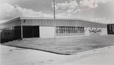 Wodonga & District Historical Society Inc
Photograph - The Sarah Coventry Pty. Ltd. building in Wodonga, Victoria, c. 1969
... Victoria. It was built in 1969 at Sarah Coventry Park, Hume Highway, Wodonga....Victoria. It was built in 1969 at Sarah Coventry Park, Hume Highway, Wodonga. ...Sarah Coventry Pty. Ltd. was a North American jewellery company that was established in 1949 by the Stuart family as part of Emmons Jewelry, Inc. It began operations in England and Australia in 1968, and in Australia it moved from Carlton in Melbourne to Wodonga in 1969. The premises were originally on High Street in Wodonga, but a new warehouse was built in Melbourne Road later in 1969. It was a direct selling jewellery business using a party-plan model similar to Tupperware and Avon. The sales reps or 'Hostesses' were provided with jewellery samples in demonstration kits, which they displayed at jewellery parties in their homes. The designs for jewellery such as brooches, necklaces, earrings, chokers and bracelets were purchased from freelance designers and jewellery manufacturers rather than in-house designers. In 1979 Sarah Coventry Pty. Ltd. in Wodonga was bought by three Australian businessmen, including Wodonga local Jim Sawyer, and continued to sell jewellery under the name "Sargem Pty. Ltd”, for several more years in the 1980s. The black and white photograph of the 1969 Sarah Coventry Pty. Ltd. warehouse in Wodonga has local significance as part of the decentralised commercial development of regional centres such as Wodonga in NE Victoria. As part of the Sarah Coventry collection, the photograph has national and international significance from the perspective of social and economic developments for women after World War II. The direct selling party-plan business model it was based on is also considered the first of its kind for jewellery.Black and white photographic print of the outside of the Sarah Coventry Pty. Ltd. building in Wodonga, Victoria. It was built in 1969 at Sarah Coventry Park, Hume Highway, Wodonga.The name "Sarah Coventry" is on the front wall of the building in the photo.sarah coventry, jewellery, wodonga, costume jewellery, vintage fashion jewellery -
 Wodonga & District Historical Society Inc
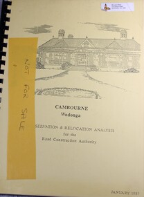
Booklet - Cambourne Wodonga : Conservation & Relocation Analysis for the Road Construction Authority, John & Thurley O'Conner, 1987
... Hume Highway. Cambourne Wodonga : Conservation & Relocation Analysis for the Road Construction Authority Booklet Cambourne Wodonga : Conservation & Relocation Analysis for the Road Construction Authority John & Thurley O'Conner Victoria Road Construction Authority ...Research paper into the viability of relocating Cambourne Homestead in 2006 in order to make way for the widening and upgrade of the Hume Highway.non-fictionResearch paper into the viability of relocating Cambourne Homestead in 2006 in order to make way for the widening and upgrade of the Hume Highway. cambourne homestead wodonga, heritage building wodonga, carkeek family, potter family, building relocation -
 Wodonga & District Historical Society Inc
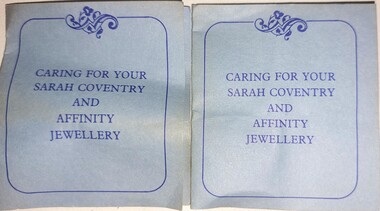
Booklet - Caring for your Sarah Coventry and Affinity Jewellery
... Victoria, as well as national and international significance from the perspective of social and economic developments for women after World War II. The direct selling party-plan business model Sarah Coventry was based on is also considered the first of its kind for jewellery. Sarah Coventry costume jewellery Industry Wodonga On Front cover: CARING FOR YOUR SARAH COVENTRY AND AFFINITY JEWELLERY On back cover: Sargem Pty. Ltd. / Hume Highway ...Sarah Coventry Pty. Ltd. was a North American jewellery company that was established in 1949 by the Stuart family as part of Emmons Jewelry, Inc. It began operations in England and Australia in 1968, and in Australia it moved from Carlton in Melbourne to Wodonga in 1969. The premises were originally on High Street in Wodonga, but a new warehouse was built in Melbourne Road later in 1969. It was a direct selling jewellery business using a party-plan model similar to Tupperware and Avon. The sales reps or 'Hostesses' were provided with jewellery samples in demonstration kits, which they displayed at jewellery parties in their homes. The designs for jewellery such as brooches, necklaces, earrings, chokers and bracelets were purchased from freelance designers and jewellery manufacturers rather than in-house designers. In 1979 Sarah Coventry Pty. Ltd. in Wodonga was bought by three Australian businessmen, including Wodonga local Jim Sawyer, and continued to sell jewellery under the name "Sargem Pty. Ltd”, for several more years in the 1980s.As part of the Sarah Coventry collection, the necklace has local significance with the decentralised commercial development of regional centres such as Wodonga in NE Victoria, as well as national and international significance from the perspective of social and economic developments for women after World War II. The direct selling party-plan business model Sarah Coventry was based on is also considered the first of its kind for jewellery.A small leaflet printed on blue paper in blue ink explaining instructions for caring for items from the Sarah Coventry rangeOn Front cover: CARING FOR YOUR SARAH COVENTRY AND AFFINITY JEWELLERY On back cover: Sargem Pty. Ltd. / Hume Highway/ WODONGA VIC, 3690 / Copyright 1979 Inside: detailed cleaning instructionsarah coventry, costume jewellery, industry wodonga -
 Wodonga & District Historical Society Inc
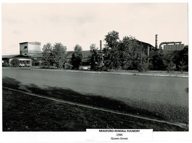
Photograph - Bradford Kendall, Wodonga
... Wodonga was ideally placed as a change point between the different rail gauges of Victoria and New South Wales, close to the Hume Highway and the Snowy Mountain Scheme. ...Wodonga was ideally placed as a change point between the different rail gauges of Victoria and New South Wales, close to the Hume Highway and the Snowy Mountain Scheme. ...Bradford Kendall was established in 1922 by Lesley Bradford and Jim Kendall, investing their winnings on a race horse. They both previously worked at the BHP Steel Works. They gained contracts with the railways and mining industry. During World War II they also manufactured armaments. During the boom of the 1950s they established several foundries in South Australia, Western Australia, Queensland and Victoria. Bradford Kendall Ltd Wodonga foundry was established in 1954. It melted down old railway wheels, rails and redundant machinery to produce a range of low-alloy steel products, especially for earth-moving vehicles, railways, oil rigs and sugar factories. Wodonga was ideally placed as a change point between the different rail gauges of Victoria and New South Wales, close to the Hume Highway and the Snowy Mountain Scheme. The first sod for the site was turned on 2nd June 1954 and the first melt and pour of molten metal at Wodonga took place on 7th July 1954. Bradford Kendall Plant No.5 in Wodonga became one of the most profitable foundries in the Bradford Kendall group. Bill Black became the first plant Manager, a position he held for 30 years. Another long term employee was Pat Gooding who began work at a 15 year old and retired for the position of Bradken foundry Manufacturing Manager 51 years later. In the early 1980s, Australian National Industries Ltd bought Bradford Kendall and other heavy engineering companies. The Wodonga foundry with its (then) 170 or so staff became part of Bradken Consolidated along with nine other foundries in Australia and New Zealand. In 1989, Kerry Packer’s Consolidated Press Holdings Ltd took control of ANI. In January 1999, Smorgon Steel Group acquired ANI, which included the Bradken business. The company changed hands again in 2001 when Smorgon Steel Group sold Bradken to Castle Harlan Australian Mezzanine Partners (CHAMP). In 2016 negotiations began for Bradken to be taken over by Hitachi Construction for A$689 million. In April 2017 Bradken became a wholly owned subsidiary of Hitachi Construction Machinery Co. Limited.A collection of black and white images and advertising for Bradford Kendall (Bradken) Wodonga.bradford kendall, wodonga industries, wodonga businesses -
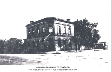 Wodonga & District Historical Society Inc
Photograph - Commercial Bank of Sydney, High Street, Wodonga, 1876 - 2025
... Victoria, at Wodonga. The site secured for the bank was at the corner of South and Sydney streets, and immediately opposite the new Post and Telegraph Offices. The original bank was demolished in the 1950s and a new bank was built on the site. The new building was constructed with innovative foundations designed to prevent damage from vibrations caused by heavy transport vehicles along High Street which was then part of the Hume Highway. ...Victoria, at Wodonga. The site secured for the bank was at the corner of South and Sydney streets, and immediately opposite the new Post and Telegraph Offices. The original bank was demolished in the 1950s and a new bank was built on the site. The new building was constructed with innovative foundations designed to prevent damage from vibrations caused by heavy transport vehicles along High Street which was then part of the Hume Highway. ...The Bank of Victoria was established in Wodonga during 1873. This two storey bank was constructed on the site in 1876. It later became the Commercial Banking Company of Sydney. In 1876 the Albury Banner and Wodonga Express reported that Mr. Nation had gained the contract for the erection of a new building for the Bank of Victoria, at Wodonga. The site secured for the bank was at the corner of South and Sydney streets, and immediately opposite the new Post and Telegraph Offices. The original bank was demolished in the 1950s and a new bank was built on the site. The new building was constructed with innovative foundations designed to prevent damage from vibrations caused by heavy transport vehicles along High Street which was then part of the Hume Highway. A contemporary newspaper article provides detail of the new bank. The well-lit building with open banking offices was designed by Melbourne architects, Turner and Stephenson, and combined a bright and attractive appearance with a stream-lined working layout. Alderson Swythyn Blackett-Smith, the manager of bank at time of move to new premises stated that the growth of the district and the bank’s business had made the old premises unsatisfactory due to insufficient space. The Commercial Banking Company of Sydney (CBC) merged with the National Bank of Australasia in 1982 to form the National Australia Bank and the second bank was closed. The building has since operated as several retail (including video hire and framing shop), commercial and community functions. It is currently (2025) used by the Wodonga Indie School.These images are significant because they document the development of an important financial institution established in Wodonga in the late 19th century.A series of images showing the evolution of the Commercial Banking Company of Sydney building in Wodonga from its construction in 1876 to the development of the site in 2025.commercial banking company of sydney, banking wodonga, wodonga financial institutions -
 Wodonga & District Historical Society Inc
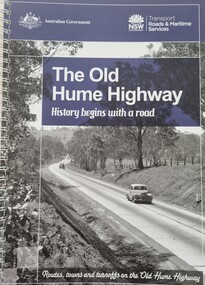
Book - The Old Hume Highway - History begins with a Road, 2014
... Hume Highway was also rerouted in Albury to avoid the town centre. Many major bypasses and duplications in New South Wales were completed throughout the 1980s and 1990s. In 1994 the last section of the Hume Highway in Victoria ...The Hume Highway was officially named in 1928, when both the New South Wales and Victorian governments agreed to give the unified inland route between Sydney and Melbourne the name, honouring explorer Hamilton Hume who, with William Hovell, first found the overland path in 1824. Much of the original highway followed their overland route wherever the landscape allowed. The road connected many small communities and rural properties, although in many parts was narrow and unsurfaced. Over the following years alterations and some deviations occurred with changing transport needs and heavier traffic loads. One of these deviations was completed in 1933 at Table Top north of Albury between Ettamogah and Mullengandra due to the construction of the Hume Weir which flooded the existing highway. Gradually sections of the road were converted to a dual carriageway. In 1961 the first modern freeway-standard, four-lane section was completed in Victoria at Craigieburn. The Hume Highway was also rerouted in Albury to avoid the town centre. Many major bypasses and duplications in New South Wales were completed throughout the 1980s and 1990s. In 1994 the last section of the Hume Highway in Victoria was duplicated with the completion of the Wangaratta bypass. The Albury-Wodonga bypass was opened in 2007 and in 2013 the final section, the Holbrook Bypass in NSW, was opened to traffic on August 7, completing the full Sydney-Melbourne dual carriageway link. In the course of this gigantic engineering achievement, many small, historic towns throughout Victoria and New South Wales were bypassed and often forgotten by passing commuters in a rush to reach their destination. This publication includes maps and information about the sites and landmarks in these towns. It encourages travellers to venture of the modern highway and rediscover the Old Hume Highway and the stories it holds about out past.A spiral bound volume of 122 pages including maps, photographs and illustrations prepared as a travel guide to the Old Hume Highway. It includes a Foreword by Peter FitzSimons.The Hume Highway was officially named in 1928, when both the New South Wales and Victorian governments agreed to give the unified inland route between Sydney and Melbourne the name, honouring explorer Hamilton Hume who, with William Hovell, first found the overland path in 1824. Much of the original highway followed their overland route wherever the landscape allowed. The road connected many small communities and rural properties, although in many parts was narrow and unsurfaced. Over the following years alterations and some deviations occurred with changing transport needs and heavier traffic loads. One of these deviations was completed in 1933 at Table Top north of Albury between Ettamogah and Mullengandra due to the construction of the Hume Weir which flooded the existing highway. Gradually sections of the road were converted to a dual carriageway. In 1961 the first modern freeway-standard, four-lane section was completed in Victoria at Craigieburn. The Hume Highway was also rerouted in Albury to avoid the town centre. Many major bypasses and duplications in New South Wales were completed throughout the 1980s and 1990s. In 1994 the last section of the Hume Highway in Victoria was duplicated with the completion of the Wangaratta bypass. The Albury-Wodonga bypass was opened in 2007 and in 2013 the final section, the Holbrook Bypass in NSW, was opened to traffic on August 7, completing the full Sydney-Melbourne dual carriageway link. In the course of this gigantic engineering achievement, many small, historic towns throughout Victoria and New South Wales were bypassed and often forgotten by passing commuters in a rush to reach their destination. This publication includes maps and information about the sites and landmarks in these towns. It encourages travellers to venture of the modern highway and rediscover the Old Hume Highway and the stories it holds about out past.old hume highway, hume highway, travel guide hume highway, \ -
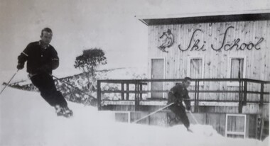 Falls Creek Historical Society
Photograph - Bernhardt Plohberger and Felix Soratroi near Falls Creek Ski School
... After leaving Falls Creek, Bernie and Trudi moved to Canberra where Bernie took work on civil engineering projects such as the coal loader in Wollongong, the Vietnam memorial in Canberra, highway work on the Hume and Sugarloaf Dam in Victoria. Bernie Plohberger died on 18 May 2020. ...After leaving Falls Creek, Bernie and Trudi moved to Canberra where Bernie took work on civil engineering projects such as the coal loader in Wollongong, the Vietnam memorial in Canberra, highway work on the Hume and Sugarloaf Dam in Victoria. Bernie Plohberger died on 18 May 2020. ...Bernard Plohberger was one of the early ski instructors at Falls Creek. He was born in Austria on 14 January 1930. He was a ski instructor before he left Austria in 1955. He spent the winter of 1956 working as a ski instructor and during the summer Bernie worked as a chainman for the SEC Surveyor. He built the Ski School at Falls Creek in 1957 as well as the Frying Pan Inn. In 1960 the Frying Pan Inn was taken over by Bill Bridgford who had helped to finance its construction. Bernie married his wife Trudi in 1958 and their son Gerhard was born at the ski school in 1959, the first child born at Falls Creek. Both Trudi and Bernie worked for Bob Hymans for a period at Grand Coeur Chalet. After leaving Falls Creek, Bernie and Trudi moved to Canberra where Bernie took work on civil engineering projects such as the coal loader in Wollongong, the Vietnam memorial in Canberra, highway work on the Hume and Sugarloaf Dam in Victoria. Bernie Plohberger died on 18 May 2020. Felix Soratroi was also an Austrian Ski Instructor who was encouraged by Bernie to move to Falls Creek and work at the Ski School.This item is significant because it depicts early Ski Instructors at Falls Creek Ski School.A black and white image of two skiers near the Falls Creek Ski School.bernard plohberger, frying pan inn, falls creek ski school, felix soratroi