Showing 28 items matching "indigenous reserves"
-
 Victorian Aboriginal Corporation for Languages
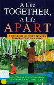
Book, Bain Attwood et al, A life together, a life apart : a history of relations between Europeans and Aborigines, 1994
... ...Indigenous reserves...Victorian Aboriginal Corporation for Languages 33 Saxon Street Brunswick melbourne Sevington Cummeragunja Moonahcullah Victorian history New South Wales history race relations racism government relations Indigenous reserves oral histories B&w photographs A history of several Aboriginal reserves, containing long transcribed narratives from those who lived there as well as letters and general information about Aboriginal-white relations in the early 20th century. ...A history of several Aboriginal reserves, containing long transcribed narratives from those who lived there as well as letters and general information about Aboriginal-white relations in the early 20th century.B&w photographssevington, cummeragunja, moonahcullah, victorian history, new south wales history, race relations, racism, government relations, indigenous reserves, oral histories -
 Eltham District Historical Society Inc
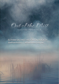
Book, Jenny Brown et al, Out of the Mist; Osborne Peninsula, 2024
... ...indigenous history...Koornong Reserve...Contents: Welcome: The landform: The River: Aboriginal occupation: The Miners: North Warrandyte :The Subdivision: The Lowes: The Osbornes: The Last Osborne: The Elders: The Relics: Dray Track: Water Wheel"Kauri Plaque: River track: Pines: Windmill Creek Bridge: The Koornong School: The Houses" Man Cave: MidCentury Classic: Enduring Original" Masterwork: The Muddies: The State Park: The Saving of Koornong Reserve: The Landcare Story: Flora and Fauna: The Vulnerable, Endangered and threatened: Birds: Mammals: "Waring" the wombat: Reptiles: Fish: Invertebrates: Flora: Fire. Published by the North Warrandyte (Osborne Peninsula) Landcare Group. Includes photos from EDHS collection. yarra river Birrarung Dray track Fauna geology houses indigenous ...The Osborne Peninsula on the Yarra River at Warrandyte accommodates a limited number of properties and residents (70 households). The area is rich in geology and ecology, and an unusually rich endowment of human, built and creative history. Contents: Welcome: The landform: The River: Aboriginal occupation: The Miners: North Warrandyte :The Subdivision: The Lowes: The Osbornes: The Last Osborne: The Elders: The Relics: Dray Track: Water Wheel"Kauri Plaque: River track: Pines: Windmill Creek Bridge: The Koornong School: The Houses" Man Cave: MidCentury Classic: Enduring Original" Masterwork: The Muddies: The State Park: The Saving of Koornong Reserve: The Landcare Story: Flora and Fauna: The Vulnerable, Endangered and threatened: Birds: Mammals: "Waring" the wombat: Reptiles: Fish: Invertebrates: Flora: Fire. Published by the North Warrandyte (Osborne Peninsula) Landcare Group. Includes photos from EDHS collection.64 p. : ill., map ; 29.7 x 21 cm. (2 copies)yarra river, birrarung, dray track, fauna, geology, houses, indigenous history, koornong reserve, koornong school, lowe family, mining, mudbrick houses, north warrandyte, osborne family, warrandyte state park, water wheel, north warrandyte (osborne peninsula) landcare group, osborne peninsula -
 Eltham District Historical Society Inc
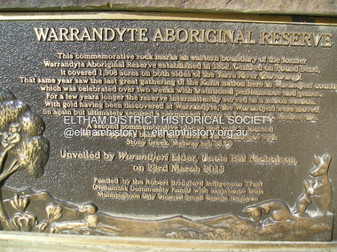
Photograph, Fay Bridge, Eastern boundary of former Warrandyte Aboriginal Reserve, North Warrandyte, 7 November 2016
... Trust (Nillumbik Community Fund) with assistance from Manningham City Council Small Grants Program Ref: Monument Autralia https://monumentaustralia.org.au/themes/culture/indigenous/display/99680-warrandyte-aboriginal-reserve-...reserve intermittently served as a ration station.With gold having been discovered at Warrandyte, the Wurundjeri were moved on again but ultimately secured a permanent home at Coranderrk, Healesville. A second commemorative plaque and rock is located on the opposite bank of the Yarra and its confluence with Stony Creek. Melway ref : 23 C 9 Unveiled by Wurundjeri Elder, Uncle Bill Nicholson on 23rd March 2013 Funded by the Robert Bridgford Indigenous ...Two bronze commemorative plaques on rocks, unveiled by Wurundjeri Tribe Council Elders, mark two eastern boundaries of the former Warrandyte Aboriginal Reserve on the north and south sides of the Yarra. This project was initiated by Nillumbik Reconciliation Group in close association with Reconciliation Manningham and the Wurundjeri Tribe Council, as a means of commemorating the last great corroboree of the Kulin Nation which was held at Pound Bend in March 1852. This plaque is on the Nillumbuk side of the Yarra, accessed via The Boulevard, North Warrandyte. The plaque is set on a rock approximately 50 metres before the turning circle at the end of The Boulevard. Plaque : Warrandyte Aboriginal Reserve This commemorative rock marks an eastern boundary of the former Warrandyte Aboriginal Reserve established in 1852. Centred on Pound Bend, it covered 1,908 acres on both sides of the Yarra River (Birrarung). That same year saw the last great gathering of the Kulin nation here in Wurundjeri country which was celebrated over two weeks with traditional performance and games. For a few years longer the reserve intermittently served as a ration station.With gold having been discovered at Warrandyte, the Wurundjeri were moved on again but ultimately secured a permanent home at Coranderrk, Healesville. A second commemorative plaque and rock is located on the opposite bank of the Yarra and its confluence with Stony Creek. Melway ref : 23 C 9 Unveiled by Wurundjeri Elder, Uncle Bill Nicholson on 23rd March 2013 Funded by the Robert Bridgford Indigenous Trust (Nillumbik Community Fund) with assistance from Manningham City Council Small Grants Program Ref: Monument Autralia https://monumentaustralia.org.au/themes/culture/indigenous/display/99680-warrandyte-aboriginal-reserve-fay bridge collection, 2016-11-07, aboriginal reserve, north warrandyte, plaques, warrandyte aboriginal reserve -
 Eltham District Historical Society Inc
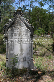
Photograph - Digital Photograph, Alan King, Queenstown Cemetery, Smiths Gully Road, St Andrews, 28 December 2007
... The box/stringybark woodland in the 1.7 hectare Cemetery Reserve is regrowth from then and the indigenous and heritage vegetation is protected. ...The box/stringybark woodland in the 1.7 hectare Cemetery Reserve is regrowth from then and the indigenous and heritage vegetation is protected. ...The discovery of gold in Smyth's Creek in 1854 and subsequent gold rush to the Caledonia diggings led to the establishment of Queenstown (present day St Andrews). The first recorded burial was July 31st, 1861 and it was officially declared a Cemetery Reserve in 1866. Many graves are unmarked and unrecorded including many Chinese and other itinerant miners. The cemetery was closed for new burials in 1851. The last recorded burial was in 1981 in an existing family grave. In Loving memory of David Band Died 30th Decr. 1862, aged 51 years. John Cork Knell Died 11th April 1867, aged 42 years. Eliza Smith Died 20th Jany. 1874, aged 3 1/2 years. William Band Died 20th Feby. 1883, aged 51 years. Published: Nillumbik Now and Then / Marguerite Marshall 2008; photographs Alan King with Marguerite Marshall.; p73 The discovery of gold at Smyth’s Creek* in 1854 brought 3000 people to the area in search of their fortunes.1 However in the harsh conditions many miners and their families died young, and were buried in unmarked graves. Their stories died with them but by 1861, the first burial was recorded at the Queenstown Cemetery – that of William Dalrymple aged 65 – although the cemetery was only officially declared a reserve in 1866. Even before this in 1856, a double burial had been recorded for the twin baby daughters of George Harrison at Market Square, the miners’ settlement – presumably where the cemetery is today. In 1951 the Queenstown Cemetery at 70 Smiths Gully Road, Smiths Gully, closed for burials. However the last burial in a family plot, that of Grace Evelyn Smith, occurred in 1981. Today only 55 headstones remain, but more than 380 burials are recorded. Remnant bushland dominates the cemetery where many graves are merely mounds and others have been damaged by vandalism and the neglect of time. Bushfire in 1962 destroyed the picket fencing, grave markers and cypress boundary planted in the early 1900s. The box/stringybark woodland in the 1.7 hectare Cemetery Reserve is regrowth from then and the indigenous and heritage vegetation is protected. Thanks to the volunteer Cemetery Trust and Friends & Relations of Queenstown Cemetery, the cemetery is maintained, stories recorded and the burial index corrected and expanded.2 Close by the cemetery on the site of today’s Peter Franke Picnic and Nature Reserve stood Market Square, the Caledonia Diggings village of tents and stores, the forerunner of Queenstown, now St Andrews. Many of the Caledonia Diggings miners were Chinese, many of whom, with itinerant prospectors, were buried in unmarked graves. Histories are being recorded of other immigrants, mainly English and German, who settled after the gold rush, some of whose descendants fought and died in the two world wars. Names on many headstones are also recorded on the district’s roads, reserves and war memorials such as Motschall, Joyce, Howard and Coutie. The oldest surviving tombstone is that of Scot, David Band who died in 1862 at 51 years. His oldest daughter Elizabeth, with husband John Knell, owned the Queenstown Hotel and the post office. Child-rearing in a colonial gold town was often tragically difficult, as demonstrated in the first 20 years, when 41% of the 34 burials recorded were children. Settlers endured harsh conditions graphically illustrated with the deaths of Annie Joyce at 30 years and of her family. Annie was married to gold miner Walter Joyce. Their third child Walter, born in 1886, died in March 1887. Eight months later Annie died of breast cancer. Walter died in 1909, aged 53, of miner’s phthisic caused by stone dust destroying his lungs. It was so hard to make a living that burials were usually held from 2.30 pm to allow mourners to work a day before paying their last respects.3 Most burials before 1890 were recorded as Anglicans, as the only church on the Caledonia Diggings was the Church of St Andrew, until 1897, when the Primitive Methodist Church came to Panton Hill. Generally miners came to better themselves, but some, like Grace Hopkinson (nee Milward), born in England in 1828, came from a well-off and educated family. According to family legend Grace emigrated with husband William, to live in a tent, but had kept her personally embossed sterling silver cutlery service. Amid the tough environment were some successes like that reported in The Evelyn Observer April/May 1901 of miner William Hopkinson who was buried at the cemetery in 1912 aged 81. The Observer stated that Hopkinson ‘recently dropped across another find in his claim at One Tree Hill’. The lump of gold found this time weighed more than half a kilo. Mr Hopkinson referred to it as ‘another little speck’. *Today’s Smiths GullyThis collection of almost 130 photos about places and people within the Shire of Nillumbik, an urban and rural municipality in Melbourne's north, contributes to an understanding of the history of the Shire. Published in 2008 immediately prior to the Black Saturday bushfires of February 7, 2009, it documents sites that were impacted, and in some cases destroyed by the fires. It includes photographs taken especially for the publication, creating a unique time capsule representing the Shire in the early 21st century. It remains the most recent comprehenesive publication devoted to the Shire's history connecting local residents to the past. nillumbik now and then (marshall-king) collection, david band, eliza smith, gravestones, john cork knell, queenstown cemetery, smiths gully road, st andrews, william band -
 Eltham District Historical Society Inc
Photograph - Digital Photograph, Alan King, Edendale Farm Homestead, 29 January 2008
... Edendale is also home to the Environmental Works staff who manage reserves and roadsides and support Nillumbik Friends environmental groups. The Friends propagate plants at the nursery, which grows indigenous plants and sells these to the public.3 The centre demonstrates the sustainable living the farm teaches, with features like solar hot water and drive lighting and for the fireplace, logs of recycled cardboard. ...Edendale is also home to the Environmental Works staff who manage reserves and roadsides and support Nillumbik Friends environmental groups. The Friends propagate plants at the nursery, which grows indigenous plants and sells these to the public.3 The centre demonstrates the sustainable living the farm teaches, with features like solar hot water and drive lighting and for the fireplace, logs of recycled cardboard. ...Edendale Farm is Nillumbik Shire Council's environment centre situated in Gastons Road, Eltham between the railway and the Diamond Creek. The homestead on the property was built in 1896 and is of historical significance, being the subject of a Heritage Overlay under the Nillumbik Planning Scheme. The Edendale property was originally part of an extensive land purchase in 1852 from the Crown by pioneer Eltham farmer Henry Stooke. He initially purchased 51 acres and later expanded his holdings by purchasing another three adjacent Crown allotments extending northerly from Josiah Holloway's Little Eltham subdivision. Despite clearing the land, Stooke did not build on this property, choosing to live on his property "Rosehill" at Lower Plenty. In 1896 Thomas Cool, Club Manager of the Victoria Coffee Palace in Melbourne purchased 7 acres of the original Stooke land and built the house now known as Edendale. Cool did not farm the land, instead using it as a gentleman’s residence, retiring to Eltham at weekends. In 1918 he purchased an additional 7 acres but in 1919 he sold the property. Later owners included J.W. Cox, the Gaston family and D. Mummery. In the 1980s the Eltham Shire Council purchased the site for use as a Council depot, but this use did not proceed. Subsequently, it was used as the Council pound. The Edendale Farm Pet Education and Retention Centre was established in the summer of 1988/1989 and was set up to replace the existing dog kennels with a high standard pet retention centre. The design style of the building was established to compliment the features of the existing house. It was equipped with 10 retention pens, a veterinary room and a pet education area where school children and other interested parties learnt about pet care procedures. It was later developed into a community farm and was run by an advisory committee and in 2000 it became an Environment Centre. In early 2006 an advisory committee was established for the development of a master plan for future development at Edendale Farm. The committee included Russell Yeoman, a former long-time shire planner and founding member of the Eltham District Historical Society. At the time of filming the Master Plan and future for Edendale was about continuing to develop Edendale as a centre of environment learning and looking at expanding displays and school program, running a lot more of life-long learning and workshops around sustainable living. Covered under Heritage Overlay, Nillumbik Planning Scheme. Published: Nillumbik Now and Then / Marguerite Marshall 2008; photographs Alan King with Marguerite Marshall.; p101 A sharp turn from busy Wattletree Road by the railway line, brings a surprise. Only 1.4 km from Eltham’s centre, sheep feed, blissfully unaware of the hectic suburban activity so close by. At the entrance to the 5.6ha Edendale Farm is another surprise. A work of art that looks like huge tree trunks transformed into bowler and top-hatted men. The Fences Act 1968 by Tony Trembath with Mark Cain and John Doyle, 1996, is classified by the National Trust of Australia as having Regional Significance. The title refers to a government act on disputes between neighbors over the placement of fences and boundaries. This takes a ‘wry swipe’ at a community divided by trivial squabbles. It also celebrates making do with limited resources.1 Further along on the left, the office wall is decorated with a massive Eltham Copper Butterfly, designed by Robert Tickner and made by school children with used plastic bottles and other waste material. Nillumbik Council runs Edendale as an Environmental Education Centre, to help preserve and enhance the local environment. As early as 1988 the former Eltham Shire Council realised Edendale’s importance in meeting people’s needs, particularly of children, to enjoy farmland. The centre, with the Eltham North Reserve to the north - including remnant bushland and open parkland - makes up the major part of the public open space for this area. The council considers this area will become increasingly important to the local community for recreational use.2 Educational programs aim to encourage community involvement to ensure the long-term rehabilitation and protection of natural bushland areas. Edendale is used by people of all ages - from school children to adults - for environmental programs and workshops, as well as for recreation, to enjoy the domestic animals and to picnic. Edendale is also home to the Environmental Works staff who manage reserves and roadsides and support Nillumbik Friends environmental groups. The Friends propagate plants at the nursery, which grows indigenous plants and sells these to the public.3 The centre demonstrates the sustainable living the farm teaches, with features like solar hot water and drive lighting and for the fireplace, logs of recycled cardboard. Edendale has had a varied history as a dog pound and even as a retreat for Thomas Cool, Club Manager of the Victoria Coffee Palace in Melbourne. His single-storey weatherboard house built in 1896, which still stands, was grander than most homes in Eltham. Although such buildings were common in many other parts of Melbourne, Eltham’s poverty and remoteness did not encourage such construction. The Victorian rectangular-shaped house, with a corrugated iron roof and veranda, has elegant large rooms, leadlight windows, ceiling roses, two bay windows and ornately carved wooden fireplace surrounds. Cool bought seven acres (2.8ha) from pioneer Eltham farmer Henry Stooke’s 200 acre (81ha) farm, which he had bought from the Crown in 1852. In 1918 Cool bought an extra seven acres (2.8ha) but in 1919 sold the estate to farmer John Cox. In 1933 Cox sold Edendale to Mrs Elizabeth Gaston, after whom the road leading to the centre was named. The property was owned by several Gaston family members, who called it Edendale, then by a police constable, Douglas Mummery, until the Shire of Eltham bought it in 1970. Oddly Edendale was known as Mummery’s for almost 20 years, although Mummery owned it only for a short time.4 The shire used Edendale as a dog pound until amalgamation with other municipalities in 1996. The pound then moved to the Yan Yean Road, Plenty site, which had been used by the former Diamond Valley Shire Council. To the west and north the centre is bounded by Diamond Creek and on the east by the Melbourne-Hurstbridge railway line. Part of the Research creek forms the centre’s southern boundary.This collection of almost 130 photos about places and people within the Shire of Nillumbik, an urban and rural municipality in Melbourne's north, contributes to an understanding of the history of the Shire. Published in 2008 immediately prior to the Black Saturday bushfires of February 7, 2009, it documents sites that were impacted, and in some cases destroyed by the fires. It includes photographs taken especially for the publication, creating a unique time capsule representing the Shire in the early 21st century. It remains the most recent comprehenesive publication devoted to the Shire's history connecting local residents to the past. nillumbik now and then (marshall-king) collection, edendale farm -
 Glen Eira Historical Society
Article - Glen Eira Parks and Gardens
... This file contains four items. 1/ An article in the Glen Eira News reporting on a new park with indigenous planting and an interpretive walk being developed to link Duncan McKinnon Reserve and Packer Park in Murrumbeena, dated September 2000. 2/ An article from the Glen Eira Leader on the converting of sports grounds from cool season to warm season grasses, as well as the installation of subsurface drip irrigation at Princes Park, Caulfield South, dated March 2012. 3/ An article from the Caulfield/Port Phillip leader reporting Caulfield RSL military historian Carl Johnson’s appeal to have a “lone pine” in Caulfield Park designated as a war memorial, dated 11/9/2012 4/ An article from the Glen Eira/Port Phillip Leader reporting on the Friends of Caulfield Park organising the first band stand concert in over twenty years with the City of Glen Eira Band, dated 6/11/2012...Glen Eira Historical Society 965 Glen Huntly Rd Caulfield VIC 3162 melbourne This file contains four items. 1/ An article in the Glen Eira News reporting on a new park with indigenous planting and an interpretive walk being developed to link Duncan McKinnon Reserve and Packer Park in Murrumbeena, dated September 2000. 2/ An article from the Glen Eira Leader on the converting of sports grounds from cool season to warm season grasses, as well as the installation of subsurface drip irrigation at Princes Park, Caulfield South, dated March 2012. 3/ An article from the Caulfield/Port Phillip leader reporting Caulfield RSL military historian Carl Johnson’s appeal to have a “lone pine” in Caulfield Park designated as a war memorial, dated 11/9/2012 4/ An article from the Glen Eira/Port Phillip Leader reporting on the Friends of Caulfield Park organising the first band stand concert in over twenty years with the City of Glen Eira Band, dated 6/11/2012 Glen Eira Council Hawthorn Rd Caulfield Glen Eira Rd Caulfield Glen Eira Caulfield Parks Reserves Leila Rd Caulfield Glen Eira City Council Landscaping Memorial Park Kooyong Rd Caulfield North Caulfield Recreation Tennis Club Murrumbeena Rd Caulfield Churchill Green housing estate North Rd Caulfield Boake Street Caulfield Exservices organisation RSL Clubs Sporting Clubs Recreations Sportsgrounds Clubs Tennis Clubs Associations Leisure Cultural Events Cultural Activities Sports Establishments Recreations Establishments Irrigation Water Conservation Conservation of Natural Resources Water Supply Ovals Playing fields Tennis Courts Murrumbeena Park School Concerts Musical Activities Musical Events Glen Eira Artists society DiMarco Lisa St. ...This file contains four items. 1/ An article in the Glen Eira News reporting on a new park with indigenous planting and an interpretive walk being developed to link Duncan McKinnon Reserve and Packer Park in Murrumbeena, dated September 2000. 2/ An article from the Glen Eira Leader on the converting of sports grounds from cool season to warm season grasses, as well as the installation of subsurface drip irrigation at Princes Park, Caulfield South, dated March 2012. 3/ An article from the Caulfield/Port Phillip leader reporting Caulfield RSL military historian Carl Johnson’s appeal to have a “lone pine” in Caulfield Park designated as a war memorial, dated 11/9/2012 4/ An article from the Glen Eira/Port Phillip Leader reporting on the Friends of Caulfield Park organising the first band stand concert in over twenty years with the City of Glen Eira Band, dated 6/11/2012glen eira council, hawthorn rd caulfield, glen eira rd caulfield, glen eira, caulfield, parks, reserves, leila rd caulfield, glen eira city council, landscaping, memorial park, kooyong rd caulfield north, caulfield recreation tennis club, murrumbeena rd caulfield, churchill green housing estate, north rd caulfield, boake street caulfield, exservices organisation, rsl clubs, sporting clubs, recreations, sportsgrounds, clubs, tennis clubs, associations, leisure, cultural events, cultural activities, sports establishments, recreations establishments, irrigation, water conservation, conservation of natural resources, water supply, ovals, playing fields, tennis courts, murrumbeena park, school concerts, musical activities, musical events, glen eira artists society, dimarco lisa, st. aloysius college, band rotundas, entertainment structures, musical ensembles, city of glen eira band, bands, the friends of caulfield park, gallipoli lone pine, princes park, packer park, duncan mckinnon reserve, king george reserve, caulfield park, glenhuntly park, glen huntly park, bentleigh reserve, victory park, schools, education establishments, recycling, water disposal, cultural structures, cultural establishments, caulfield rsl, johnson carl, war memorials, monuments, memorials, avenue of honour, “lone pine”, glen eira leader, glen eira news, caulfield/port phillip leader, glen eira leader -
 Eltham District Historical Society Inc
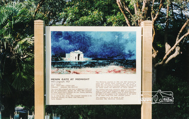
Photograph, Information Panel: Will Longstaff's "Menin Gate at Midnight"
... In April 2002, illustrative panels were set in place at Kangaroo Ground War Memorial Park designed to inform visitors about significant aspects of the reserve and its tower. One of these deals with its indigenous story, another portrays its original 1920 memorial, a third has upon it Will Longstaff’s famous war painting, “Midnight at Menin Gate.” ...Eltham District Historical Society Inc 728 Main Rd Eltham melbourne In April 2002, illustrative panels were set in place at Kangaroo Ground War Memorial Park designed to inform visitors about significant aspects of the reserve and its tower. One of these deals with its indigenous story, another portrays its original 1920 memorial, a third has upon it Will Longstaff’s famous war painting, “Midnight at Menin Gate.” ...In April 2002, illustrative panels were set in place at Kangaroo Ground War Memorial Park designed to inform visitors about significant aspects of the reserve and its tower. One of these deals with its indigenous story, another portrays its original 1920 memorial, a third has upon it Will Longstaff’s famous war painting, “Midnight at Menin Gate.” This sign establishes a connection with the First World War by way of the painting "Menin Gate at Midnight". (NL 144) The artist William Longstaff lived in Eltham; his son attended school at Kangaroo Ground. The orignal of his painting is on permanent display in the Australian War Memorial. Since this photograph was taken (date unknown) the information panel has been restored and re-erected by staff of the Shire of Nillumbik who replicated the wooden side frame pieces with the same wood-turn design as seen here in the original. Colour photographMENIN GATE AT MIDNIGHT Will Longstaff, 1927 Oil on canvas, Size 135cm high x 254cm wide Collection: Australian War Memorial The artist Will Longstaff was born in in Ballarat in 1879 and died at Littlehampton, Sussex, UK, 1953. Will Longstaff for many years lived in Eltham, his son Tommy, attending school at Kangaroo Ground. As an Official War Artist, will Longstaff depicted in his alegorical painting the Menin Gate Memorial, Ypres, Belgium. The Memorial unveiled on 24th July 1927 honours by name over 50, 000 allied soldiers who fell in the Great War and have no known graves. The names of 6,208 men of the first Australian Imperial Force (A.I.F.) are listed within the Memorial on stone tablets. The painting held huge emotional appeal to Australians when it arrived from England in 1928, attracting an estimated one million viewers, many of whom interpreted the field of red poppies in the foreground as the spirits of the dead rising from their unknown graves. The painting is to be found in the Australian War Memorial, Canberra.menin gate at midnight, william longstaff, kangaroo ground memorial, information panel, shire of eltham war memorial -
 Flagstaff Hill Maritime Museum and Village
Postcard - Scenic, Warrnambool, Tower Hill and Lake, Warrnambool, 1902-1929
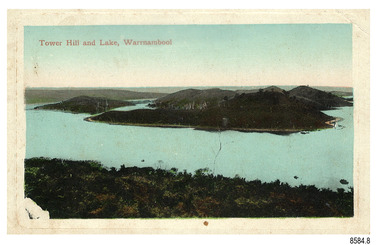
... Reserve is in the crater of a dormant volcano. In 1892 the area was declared a National Park, the first in Victoria, preserving native animals and Indigenous plants. ...Reserve is in the crater of a dormant volcano. In 1892 the area was declared a National Park, the first in Victoria, preserving native animals and Indigenous plants. ...The nine postcards in this set were donated together and date to the early 1900s. All but one postcard in this set shows images of Warrnambool, in the Western District of Victoria; the other has a London image. The postcards were all printed in Great Britain according to that country’s postal regulations. The fronts of all cards have titles printed in red. Most of the images on the cards are attributed to photographer Joseph Jordan and belong to the Jordan Series. The back of these cards has an outline for a postage stamp, a vertical dividing line and a heading on each side of the line to separate the Correspondence from the Address. Postcards or ‘correspondence cards’ appeared in Britain in 1894. They were plain cards with a space for the message on one side and an address on the other; regulations didn’t allow anything but the address to be written on the ‘address’ side. In 1902 the British regulations then allowed a picture to be printed on the front and the address on the back, so messages had to be written on the picture side. Soon, the regulations changed and the back was divided for a message and the address. Tower Hill and Lake, Warrnambool – Tower Hill Wildlife Reserve is in the crater of a dormant volcano. In 1892 the area was declared a National Park, the first in Victoria, preserving native animals and Indigenous plants. The rich volcanic soil in the area attracted early settlers including the families of Henry Giles, born at Tower Hill in 1858 and his wife Mary Jane (born Freckleton) born nearby at Cooramook in 1860. Henry and Mary worked in the local area where they also raised their six children. For a time, Henry was employed as a labourer on the Warrnambool Breakwater. Joseph Jordan - Joseph Jordan was born in 1841 in Leicester England. When he was 16 he joined the 7th Queen's Own Hussars and was sent to India at the outbreak of the mutiny. He took part in the relief of Lucknow and remained in India for eleven years. It was during this time that he became interested in photography. He was posted to New Zealand and later came to Victoria, becoming a sergeant major of the Mounted Rifles. In the mid-1880s he came to the Western district where he was responsible for establishing units of the Mounted Rifles in various country towns such as Dunkeld, Mortlake, Panmure, Bushfield, Koroit etc. He resigned from the army in 1889 and set up a professional photography studio in Liebig Street, Warrnambool. He became very well known in the Western District for family photographs, official photographs of local councillors and groups as well as views of local scenery. In 1891 he photographed the wrecked barque ‘Fiji’ at ‘Wrecks Beach’ near Princetown. His business was taken over by his son Arthur around 1917. Joseph was a keen rifle shot and in 1924 he donated the "Jordan Shield" as a prize to the Victorian Rifle Association. He was made a "Life Honorary Member" of the Warrnambool Returned Soldiers League and in 1933 he was recognised as being the oldest living soldier in Victoria. Joseph died in 1935 aged 95.The postcard of Tower Hill and Lake is connected to the location near Warrnambool where many of our early settlers lived and worked. One of these settlers was the Giles family, whose son Henry was born at Tower Hill. His family has donated many Victorian-era items which are now on display at Flagstaff Hill. Tower Hill National Park is the first place in Victoria to be named a National Park. As in the times when coastal trading ships brought passengers and cargo to the Port of Warrnambool, it continues to be a popular place to visit. Joseph Jordan is a significant figure in Warrnambool history as he helped to establish early units of the Mounted Rifles (G Company) in local towns during the late 1880's and later, photographed local scenes, groups and citizens of early Warrnambool.Postcard, one of nine, landscape orientation, coloured print within a rectangle and an impressed line around the image on the front. The picture shows several islands close together with hills around them and bushland in the foreground. There are dead trees amongst the vegetation and a sandy shore at the foot of some of the hills. The lower left corner shows what appears to be two white rails, possibly a lookout fence. There is no correspondence written on the card. The title is printed in red on the front and the back has inscriptions and outlines for a postage stamp. Jordan Series, printed in Great Britain. Front, in red: “Tower Hill Lake, Warrnambool” Back in green: “Jordan Series” “POST CARD” “PRINTED IN GREAT BRITAIN” “For correspondence” “The Address only to be written here”flagstaff hill maritime museum, flagstaff hill maritime village, flagstaff hill maritime museum and village, maritime museum, warrnambool, great ocean road, warrnambool and district, warrnambool scenes, local scenes, views of warrnambool, joseph jordan, jordan series, jordan photography, postcard, souvenir, correspondence, cameo postcard, tower hill, tower hill national park, victoria's first national park, henry giles, mary jane freckleton, breakwater, early settlers -
 Ringwood and District Historical Society
Newspaper, Scrapbook Clipping, Library Collection, Ringwood, Victoria, `
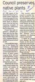
... indigenous understorey flora in Ringwood. Council last week negotiated a $48,000 purchase price for the triangular shaped block at the end of Debbie Place, next to B.J. Hubbard Reserve...indigenous understorey flora in Ringwood. Council last week negotiated a $48,000 purchase price for the triangular shaped block at the end of Debbie Place, next to B.J. Hubbard Reserve ...``Newspaper clipping from "The Post", 24-2-93, P 3. Council preserves native plants At the request of the Society For Growing Australian Plants, Ringwood Council has agreed to buy a vacant house block to preserve some of the last and best remaining examples of indigenous understorey flora in Ringwood. Council last week negotiated a $48,000 purchase price for the triangular shaped block at the end of Debbie Place, next to B.J. Hubbard Reserve, which had been advertised for sale. ` -
 Victorian Aboriginal Corporation for Languages
Periodical, Australian Institute of Aboriginal and Torres Strait Islander Studies, Australian Aboriginal studies : journal of the Australian Institute of Aboriginal and Torres Strait Islander Studies, 2008
... Indigenous programs. Reaching out to a younger generation using a 3D computer game for storytelling: Vincent Serico?s legacy Theodor G Wyeld (Flinders University, Adeliade) and Brett Leavy (CyberDreaming Australia) Sadly, Vincent Serico (1949?2008), artist, activist and humanist, recently passed away. Born in southern Queensland in Wakka Wakka/Kabi Kabi Country (Carnarvon Gorge region) in 1949, Vincent was a member of the Stolen Generations. He was separated from his family by White administration at four years of age. He grew up on the Cherbourg Aboriginal Reserve...Indigenous programs. Reaching out to a younger generation using a 3D computer game for storytelling: Vincent Serico?s legacy Theodor G Wyeld (Flinders University, Adeliade) and Brett Leavy (CyberDreaming Australia) Sadly, Vincent Serico (1949?2008), artist, activist and humanist, recently passed away. Born in southern Queensland in Wakka Wakka/Kabi Kabi Country (Carnarvon Gorge region) in 1949, Vincent was a member of the Stolen Generations. He was separated from his family by White administration at four years of age. He grew up on the Cherbourg Aboriginal Reserve ...Mawul Rom Project: Openness, obligation and reconciliation Morgan Brigg (Universtiy of Queensland) and Anke Tonnaer (University of Aarhus, Denmark) Aboriginal Australian initiatives to restore balanced relationships with White Australians have recently become part of reconciliation efforts. This paper provides a contextualised report on one such initiative, the Mawul Rom crosscultural mediation project. Viewing Mawul Rom as a diplomatic venture in the lineage of adjustment and earlier Rom rituals raises questions about receptiveness, individual responsibility and the role of Indigenous ceremony in reconciliation efforts. Yolngu ceremonial leaders successfully draw participants into relationship and personally commit them to the tasks of cross-cultural advocacy and reconciliation. But Mawul Rom must also negotiate a paradox because emphasis on the cultural difference of ceremony risks increasing the very social distance that the ritual attempts to confront. Managing this tension will be a key challenge if Mawul Rom is to become an effective diplomatic mechanism for cross-cultural conflict resolution and reconciliation. Living in two camps: the strategies Goldfields Aboriginal people use to manage in the customary economy and the mainstream economy at the same time Howard Sercombe (Strathclyde University, Glasgow) The economic sustainability of Aboriginal households has been a matter of public concern across a range of contexts. This research, conducted in the Eastern Goldfields of Western Australia, shows how economically successful Aboriginal persons manage ?dual economic engagement?, or involvement in the customary economy and the mainstream economy at the same time. The two economies sometimes reinforce each other but are more often in conflict, and management of conflicting obligations requires high degrees of skill and innovation. As well as creating financially sustainable households, the participants contributed significantly to the health of their extended families and communities. The research also shows that many Aboriginal people, no matter what their material and personal resources, are conscious of how fragile and unpredictable their economic lives can be, and that involvement in the customary economy is a kind of mutual insurance to guarantee survival if times get tough. Indigenous population data for evaluation and performance measurement: A cautionary note Gaminiratne Wijesekere (Dept. of Families, Housing, Community Services and Indigenous Affairs, Canberra) I outline the status of population census counts for Indigenous peoples, identifying information on Indigenous births and deaths, and internal migration estimates. I comment on the ?experimental? Indigenous population projections and question the rationale for having two sets of projections. Program managers and evaluators need to be mindful of limitations of the data when using these projections for monitoring, evaluating and measuring Indigenous programs. Reaching out to a younger generation using a 3D computer game for storytelling: Vincent Serico?s legacy Theodor G Wyeld (Flinders University, Adeliade) and Brett Leavy (CyberDreaming Australia) Sadly, Vincent Serico (1949?2008), artist, activist and humanist, recently passed away. Born in southern Queensland in Wakka Wakka/Kabi Kabi Country (Carnarvon Gorge region) in 1949, Vincent was a member of the Stolen Generations. He was separated from his family by White administration at four years of age. He grew up on the Cherbourg Aboriginal Reserve in the 1950s, when the policies of segregation and assimilation were at their peak. Only returning to his Country in his early forties, Vincent started painting his stories and the stories that had been passed on to him about the region. These paintings manifest Vincent?s sanctity for tradition, storytelling, language, spirit and beliefs. A team of researchers was honoured and fortunate to have worked closely with Vincent to develop a 3D simulation of his Country using a 3D computer game toolkit. Embedded in this simulation of his Country, in the locations that their stories speak to, are some of Vincent?s important contemporary art works. They are accompanied by a narration of Vincent?s oral history about the places, people and events depicted. Vincent was deeply concerned about members of the younger generation around him ?losing their way? in modern times. In a similar vein, Brett Leavy (Kooma) sees the 3D game engine as an opportunity to engage the younger generation in its own cultural heritage in an activity that capitalises on a common pastime. Vincent was an enthusiastic advocate of this approach. Working in consultation with Vincent and the research team, CyberDreaming developed a simulation of Vincent?s Country for young Aboriginal and non-Aboriginal persons from the Carnarvon Gorge region to explore Vincent?s life stories of the region. The use of Vincent?s contemporary paintings as storyboards provides a traditional medium for the local people to interactively re-engage with traditional values. Called Serico?s World, it represents a legacy to his life?s works, joys and regrets. Here we discuss the background to this project and Vincent?s contribution. A singular beeswax representation of Namarrkon, the Lightning Man, from western Arnhem Land RG Gunn (La Trobe University) and RL Whear (Jawoyn Association) Samples from a beeswax representation of Namarrkon, the Lightning Man, from western Arnhem Land were analysed for radiocarbon and dated to be about 150 years old. An underlying beeswax figure was found to be approximately 1100 years old. The Dreaming Being Namarrkon is well known throughout Arnhem Land, although his sphere of activity is concentrated around the northern half of the Arnhem Land plateau. Namarrkon is well represented in rock-paintings in this area and continues to be well represented in contemporary canvas-paintings by artists from the broader plateau region. We conclude that representations of Namarrkon in both painted and beeswax forms appear to be parallel manifestations of the late Holocene regionalisation of Arnhem Land. ?Missing the point? or ?what to believe ? the theory or the data?: Rationales for the production of Kimberley points Kim Akerman (Moonah) In a recent article, Rodney Harrison presented an interesting view on the role glass Kimberley points played in the lives of the Aborigines who made and used them. Harrison employed ethnographic and historical data to argue that glass Kimberley points were not part of the normal suite of post-contact artefacts used primarily for hunting and fighting or Indigenous exchange purposes, but primarily were created to service a non-Indigenous market for aesthetically pleasing artefacts. Harrison asserted that this market determined the form that these points took. A critical analysis of the data does not substantiate either of these claims. Here I do not deal with Harrison?s theoretical material or arguments; I focus on the ethnographic and historical material that he has either omitted or failed to appreciate in developing his thesis and which, in turn, renders it invalid. The intensity of raw material utilisation as an indication of occupational history in surface stone artefact assemblages from the Strathbogie Ranges, central Victoria Justin Ian Shiner (La Trobe University, Bundoora) Stone artefact assemblages are a major source of information on past human?landscape relationships throughout much of Australia. These relationships are not well understood in the Strathbogie Ranges of central Victoria, where few detailed analyses of stone artefact assemblages have been undertaken. The purpose of this paper is to redress this situation through the analysis of two surface stone artefact assemblages recorded in early 2000 during a wider investigation of the region?s potential for postgraduate archaeological fieldwork. Analysis of raw material utilisation is used to assess the characteristics of the occupational histories of two locations with similar landscape settings. The analysis indicates variability in the intensity of raw material use between the assemblages, which suggests subtle differences in the occupational history of each location. The results of this work provide a direction for future stone artefact studies within this poorly understood region.document reproductions, maps, b&w photographs, colour photographskimberley, mawul rom project, 3d computer game, storytelling, vincent serico, beeswax, namarrkon, artefact assemblages, strathbogie ranges, groote eylandt, budd billy ii -
 Victorian Aboriginal Corporation for Languages
Book, Aboriginal Community Elders Service et al, Aboriginal elders' voices : stories of the "tide of history" : Victorian Indigenous elders' life stories &? oral histories, 2003
... Contents: The writing team Indigenous elders: keepers of knowledge; custodians of land and culture Aboriginal lands Missions and reserves Growing up running from the welfare /? ...Contents: The writing team Indigenous elders: keepers of knowledge; custodians of land and culture Aboriginal lands Missions and reserves Growing up running from the welfare /? ...This book is a collection of Victorian Indigenous Elders' life stories and oral histories. The Elders share their stories in an attempt to ensure that both sides of Australia's history are finally heard. These stories tell of cultural resistance on missions, of defying assimilation laws, of forever moving around to save children from the welfare. They document the development of both fringe and urban communities and work in the Aboriginal rights movement. They clarify the ways in which these experiences have affected the individual authors along with the indigenous population in general. Also included in the book is a brief history and analysis of the legislation, policies, attitudes and strategies that have affected the lives of the authors and their families since colonisation. This aspect provides an historical perspective, encouraging a deeper understanding of the Elders' stories. Reconciliation can only eventuate with an understanding gained from hearing and including the voices of Indigenous Australians. Contents: The writing team Indigenous elders: keepers of knowledge; custodians of land and culture Aboriginal lands Missions and reserves Growing up running from the welfare /? Aunty Olive Jackson Respecting our Elders /? Aunty Lola James If your mother didn't tell you, then your grandmother did! /? Uncles Les Stewart Don't dwell on trouble /? Aunty Audrey Critch There are my people /? Aunty Gwen Nelson We were all cousins, more or less /? Aunty Iris Lovett-Gardiner Aboriginality is about culture, not colour /? Aunty Dianne Phillips Take up the opportunities we struggled to make /? Aunty Frances Gallagher Home /? Aunty Eileen Alberts We were supposed to forget our Aboriginality /? Aunty Gwen Garoni Not enough heart to say sorry? /? Uncle Brian Kennewell-Taylor Learning from indigenous elders: Keeping the traditions, keeping the culture strong; Since time immemorial; Invasion: the tide ran red; The flood of legislation; Stolen children; Cultural resistance: holding on to children traditions and land; Organised resistance: a movement is born; The 1950s: community resistance to race laws; The price of assimilation; The Aboriginal rights movement; After the flood: self-determination; Turning the tide Bibliography Appendix. Cultural custodianship: developing an indigenous methodology.maps, colour illustrations, b&w photographswiradjuri, victorian indigenous elders, oral histories, yorta yorta, dja dja wurrung, language maps, victorian missions and reserves, lake condah, framlingham, coranderrk, ramahyuck, lake tyers, wahgunyah, cummeragunja, moonahcullah, balranald, ebenezer, maloga, acheron -
 Victorian Aboriginal Corporation for Languages
Book, Catholic Education Commission of Victoria, Koorie studies in SOSE : years 7-10, 2001
... Aboriginal mission stations and reserves in Victoria Unit 8. Land, law and indigenous Australians Section 5. ...Aboriginal mission stations and reserves in Victoria Unit 8. Land, law and indigenous Australians Section 5. ...Section 1. Notes on the use of this resource Section 2. Policy support statements. Aboriginal Studies Policy Statement of Victorian Aboriginal Education Association Incorporated (VAEAI) National Principles and Guidelines for Aboriginal Studies and Torres Strait Islander Studies, K-12 Principles for the Introduction of Aboriginal Perspectives in the Curriculum of the Catholic School (Catholic Education Commission of Victoria Policy 1.3, 1987) Section 3. Language, culture and viewpoint: issues of terminology Section 4. Units of work Unit 1. Koorie people of south-east Australia: a contemporary view Unit 2. On sacred ground Unit 3. Koorie life in the pre-contact era Unit 4. Mulla Meea-Baa Gnuenjall: a long time ago, and today Unit 5. The land we share: human stories in the environment Unit 6. Frontier wars Unit 7. Aboriginal mission stations and reserves in Victoria Unit 8. Land, law and indigenous Australians Section 5. Directory of indigenous organisations and affiliated groups/?agencies. National organisations Victorian organisations Catholic Education Commission of Victoria Indigenous Education personnel Organisations within regions of the Archdiocese of Melbourne Organisations within regions of the Ballarat Diocese Organisations within regions of the Sale Diocese Organisations within regions of the Sandhurst Diocese Cultural centres/?camps across Victoria.maps, b&w photographsvaeai, history, curriculum development, koorie studies, catholic education commission of victoria, secondary school education, -
 Whitehorse Historical Society Inc.
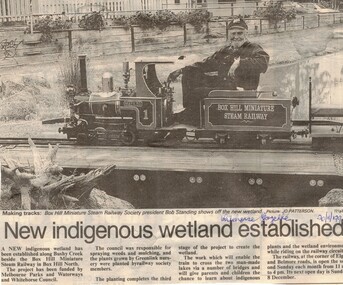
Article, New indigenous wetland established, 20/11/1996 12:00:00 AM
... Whitehorse Historical Society Inc. 2-10 Deep Creek Road Mitcham melbourne miniature railways bushy creek reserve box hill miniature steam railway standing robert Whitehorse Gazette 20 November 1996 on Box Hill Miniature steam railway, Illustrated article from Whitehorse Gazette 20 November 1996 on Box Hill Miniature steam railway, Box Hill North, New indigenous wetland established Article Article ...Whitehorse Gazette 20 November 1996 on Box Hill Miniature steam railway,Illustrated article from Whitehorse Gazette 20 November 1996 on Box Hill Miniature steam railway, Box Hill North,Whitehorse Gazette 20 November 1996 on Box Hill Miniature steam railway,miniature railways, bushy creek reserve, box hill miniature steam railway, standing, robert -
 Whitehorse Historical Society Inc.
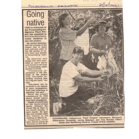
Article, Going native, 27/02/1991 12:00:00 AM
... An article in the Nunawading Gazette calling for new volunteers to join the Nunawading Indigenous Plants Project to plant and cultivate some of the 200 species of native trees and grasses in Nunawading reserves....Whitehorse Historical Society Inc. 2-10 Deep Creek Road Mitcham melbourne native plants nunawading indigenous plants project trees witherspoon margaret strachan janine mundell tina An article in the Nunawading Gazette calling for new volunteers to join the Nunawading Indigenous Plants Project to plant and cultivate some of the 200 species of native trees and grasses in Nunawading reserves. ...An article in the Nunawading Gazette calling for new volunteers to join the Nunawading Indigenous Plants Project to plant and cultivate some of the 200 species of native trees and grasses in Nunawading reserves.native plants, nunawading indigenous plants project, trees, witherspoon, margaret, strachan, janine, mundell, tina -
Whitehorse Historical Society Inc.
Article, Project That Makes Us Proud, 1991
... Mostly by Volunteers, done to keep our reserves planted with indigenous plants and the background organization required....Article describing the work, mostly by Volunteers, done to keep our reserves planted with indigenous plants and the background organization required....Whitehorse Historical Society Inc. 2-10 Deep Creek Road Mitcham melbourne Mostly by Volunteers, done to keep our reserves planted with indigenous plants and the background organization required. ...Article describing the planting ans organisation work.Article describing the work, mostly by Volunteers, done to keep our reserves planted with indigenous plants and the background organization required.Article describing the planting ans organisation work.parks and reserves, reid, wendy, blackburn and district tree preservation society -
Whitehorse Historical Society Inc.
Article, Residents Enjoy the Bonus of Wildlife Oasis in Back Yards, 1993
... Since the planting of indigenous plants and trees the birdlife and fauna have returned. Parks and Reserves Grounds David Dr. ...Article about Blackburn Creeklands.Article about Blackburn Creeklands which is looked after by Nunawading Council and the Blackburn Creeklands Committee. Since the planting of indigenous plants and trees the birdlife and fauna have returned.Article about Blackburn Creeklands.parks and reserves, grounds, david dr., blackburn creeklands committee, short, megan, city of nunawading -
 Whitehorse Historical Society Inc.
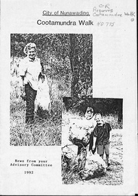
Pamphlet, Cootamundra Walk, 1992
... Whitehorse Historical Society Inc. 2-10 Deep Creek Road Mitcham melbourne parks and reserves williams road blackburn goodwin street cootamundra walk blackburn high school environment awareness group skillshare nunawading greening australia burnley agricultural college city of nunawading nunawading indigenous plants project News from the Cootamundra Walk Advisory Committee describing work being done with the help of various organisations. ...News from the Cootamundra Walk Advisory Committee describing work being done with the help of various organisations.parks and reserves, williams road, blackburn, goodwin street, cootamundra walk, blackburn high school environment awareness group, skillshare, nunawading, greening australia, burnley agricultural college, city of nunawading, nunawading indigenous plants project -
 Port Fairy Historical Society Museum and Archives
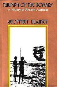
Book, Macmillan Publishers Group Australia Pty Ltd, Triumph of the nomads : a History of Ancient Australia, 1982
... Port Fairy Historical Society Museum and Archives 30 Gipps Street Port Fairy great-ocean-road Argues that Australia's Indigenous people discovered the land, adapted it and mastered its climates, seasons & reserves. habitation - nomadism. demography - palaeodemography - aboriginal settlement of australia. reproduction - infanticide. feuds and warfare. hunting gathering and fishing. food - plants. trade and exchange - trade routes. australiens (aborign̈es) aborigines australian -- social life and customs. aboriginal australians -- social life and customs -- northern territory. aboriginal australians -- history. aboriginal australians -- culture -- history. aboriginal australians -- civilization -- history. aboriginal australians -- economic conditions -- history. aboriginal australians -- social life and customs. human ecology -- australia. aboriginal australians. aborigines. australiens (aborigènes) australien. australia -- history. lake mungo / walls of china (willandra sw nsw si54-08) tasmania (tas) australia - aborigines Book Argues that Australia's Indigenous people discovered the land, adapted it and mastered its climates, seasons & reserves. 23.0 x 14.0cms, 938 pp. b/w illust dust jacket Triumph of the nomads : a History of Ancient Australia. ...Argues that Australia's Indigenous people discovered the land, adapted it and mastered its climates, seasons & reserves.23.0 x 14.0cms, 938 pp. b/w illust dust jacketnon-fictionArgues that Australia's Indigenous people discovered the land, adapted it and mastered its climates, seasons & reserves.habitation - nomadism., demography - palaeodemography - aboriginal settlement of australia., reproduction - infanticide., feuds and warfare., hunting, gathering and fishing., food - plants., trade and exchange - trade routes., australiens (aborign̈es), aborigines, australian -- social life and customs., aboriginal australians -- social life and customs -- northern territory., aboriginal australians -- history., aboriginal australians -- culture -- history., aboriginal australians -- civilization -- history., aboriginal australians -- economic conditions -- history., aboriginal australians -- social life and customs., human ecology -- australia., aboriginal australians., aborigines., australiens (aborigènes), australien., australia -- history., lake mungo / walls of china (willandra sw nsw si54-08), tasmania (tas), australia - aborigines, book -
 Whitehorse Historical Society Inc.
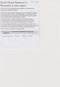
Article, Scott Grove Reserve, Aug 2023
... The reserve includes 50 trees, local indigenous plants, a picnic table and seating, fitness equipment, a playground and a nature play area....Whitehorse Historical Society Inc. 2-10 Deep Creek Road Mitcham melbourne The reserve includes 50 trees, local indigenous plants, a picnic table and seating, fitness equipment, a playground and a nature play area. ...A new open space park has been established at 14 - 16 Scott Grove, Burwoodnon-fictionA new open space park has been established at 14 - 16 Scott Grove, Burwoodscott grove reserve, scott grove burwood no 14 -16, playgrounds -
 Ballarat Heritage Services
Photograph - Digital photograph, Dorothy Wickham, Winter's Swamp, Ballarat, January to April 2014
... In this regard, the more contemporary history of actions surrounding the use and management of the reserves is of particular interest, in view of the extant evidence at both reserves; e.g. the actions of the Shire of Ballarat in the 1980s in establishing Winter Swamp as something of a competitor to Lake Wendouree but with a more environmental bent (although almost none of the plants used are indigenous species, but that is part of the story); the trotting track constructed on Skipton Common in the 1960s following representations to Premier Henry Bolte and the cropping of the western section of the Common to raise funds for the town’s new swimming pool, the fertilizing of the land putting an end to the native grassland vegetation. ...Study of Winter's Swamp commissioned by BEN and completed by BHS. The swamp was named after one of the first European settlers in the district. Winter Swamp LAT -37 32 LONG 143 47, Parish of Dowling Forest, County of Grenville Winter Swamp, on the southwest corner of Ballarat West Town Common, was not included in the original proclamation of the Common in 1861. However, being marshland, it was not considered suitable for grazing, so was added to the Common soon after 1861. Winter Swamp is a large wetland with native and exotic pasture significant for wildlife. John Winter (Jock) was born in Berwickshire, Scotland. He married Janet Margaret Irving the daughter of Robert Irving, advocate, Bonshaw, Dumfries, Scotland. Winter died in Ballarat in 1875 and was buried at the Ballaarat Old Cemetery. He took up the run Bonshaw from 1841; Leigh River Buninyong 1842-46; Junction, Delatite, March 1851 to September 1862; with sons: Carag Carag and Corop, April 1857 to September 1872; Colbinabbin and Stewart’s Plains, April 1857 to December 1872; St Germains February 1867 to March 1871. (The name became Winter-Irving in 1890). Mr John Winter, who died on August 22 at the age of 72, was a man of some note it the mining community of Ballarat. He was a self-made man, and one of our oldest colonists, it being over a quarter of a century age since he took up county about Ballarat and settled at Bonshaw. He died very rich. It is calculated that if he had retained an interest in all his runs, his income must have been not less than £10,000 or £50,000 a year. Some eight or ten years ago he sold his Bonshaw pre-emption to the Bonshaw Gold mining Company for £20,000, and a few years later the ground belonging now to Winter's Freehold Company brought him £50,000 more, the payment being made at the requisition of the deceased in sovereigns. In these relations Mr. Winter has been closely identified with the mining industry at Ballarat. The deceased was a native of Lauder, in Berwickshire, and landed in Victoria several years before the gold discovery.The principle task of this project was the delivery of a report outlining the history of European settlement in the Skipton and Cardigan/Ballarat districts as pertinent to the use of and impact on the natural environment of the two reserves Skipton Common and Winter Swamp. The report was delivered in digital form only. The report, upon completion, was presented to the Network’s Committee in order to discuss the project. The report identified and described the uses of Skipton Common and Winter Swamp, and their impacts. In particular, this report examined farming/grazing (official and informal), mining, vegetation removal (including the removal of woodlands for timber, grasslands for pasture improvement) & use of riparian areas for access to water and timber removal. Recording the more benign and environmentally friendly uses such as picnicking, community activities, nature walks and the roles of organisations such as Field Naturalists’ and Bird Observers’ clubs, school and scout/guide groups will be relevant in helping to depict overall community attitudes towards the reserves; e.g.: has the Common generally been viewed as little more than a grazing paddock and fire hazard; has Winter Swamp always been the unknown natural asset that seems to have been its lot for at least the past 40 years? In this regard, the more contemporary history of actions surrounding the use and management of the reserves is of particular interest, in view of the extant evidence at both reserves; e.g. the actions of the Shire of Ballarat in the 1980s in establishing Winter Swamp as something of a competitor to Lake Wendouree but with a more environmental bent (although almost none of the plants used are indigenous species, but that is part of the story); the trotting track constructed on Skipton Common in the 1960s following representations to Premier Henry Bolte and the cropping of the western section of the Common to raise funds for the town’s new swimming pool, the fertilizing of the land putting an end to the native grassland vegetation. There are obviously multiple sources of information to source in preparing the report, however sources that the contractor is specifically requested to consult are the Skipton Historical Society, the former Skipton Common managers (specifically Graeme Pett), the Cardigan Windermere Landcare Group and the Learmonth Historical Society (believed to hold many of the former Shire of Ballarat’s records pertaining to the Council’s role as the Committee of Management for both Winter Swamp and the Ballarat West Town Common – Winter Swamp was split between 2 separate Crown Land tenures). The contractor is also encouraged but not required to utilise community newsletters, such as the Skipton Community Newsletter, to publicise and seek information about the project. Skipton Historical Society (Mary Bradshaw) contacted on Thursday 12 June 2.30pm. Mary lived on a farm out of Skipton but is currently living in the township. She remembers walking along the creek of the Common especially in spring and autumn in bare feet and that it was a very pretty place. There were a few snakes around the waterway in summer. People put cows and a couple of horses on the commonage to graze. Graeme Pett has always lived close to the Common and would know a lot about it. Other possible contacts would be Nicole Petress, Secretary of the Progress Association, and the Corangamite Council, Camperdown. Digital images of Winter's Swampwinter's swamp, ballarat, john winter, ballarat environmental network, mullawullah -
 Ballarat Heritage Services
Photograph - Digital photograph, Winter's Swamp surrounds, April 2014
... In this regard, the more contemporary history of actions surrounding the use and management of the reserves is of particular interest, in view of the extant evidence at both reserves; e.g. the actions of the Shire of Ballarat in the 1980s in establishing Winter Swamp as something of a competitor to Lake Wendouree but with a more environmental bent (although almost none of the plants used are indigenous species, but that is part of the story); the trotting track constructed on Skipton Common in the 1960s following representations to Premier Henry Bolte and the cropping of the western section of the Common to raise funds for the town’s new swimming pool, the fertilizing of the land putting an end to the native grassland vegetation. ...The swamp was named after John (Jock) Winter. John Winter (Jock) was born in Berwickshire, Scotland. He married Janet Margaret Irving the daughter of Robert Irving, advocate, Bonshaw, Dumfries, Scotland. Winter died in Ballarat in 1875 and was buried at the Ballaarat Old Cemetery. He took up the run Bonshaw from 1841; Leigh River Buninyong 1842-46; Junction, Delatite, March 1851 to September 1862; with sons: Carag Carag and Corop, April 1857 to September 1872; Colbinabbin and Stewart’s Plains, April 1857 to December 1872; St Germains February 1867 to March 1871. (The name became Winter-Irving in 1890). Mr John Winter, who died on August 22 at the age of 72, was a man of some note it the mining community of Ballarat. He was a self-made man, and one of our oldest colonists, it being over a quarter of a century age since he took up county about Ballarat and settled at Bonshaw. He died very rich. It is calculated that if he had retained an interest in all his runs, his income must have been not less than £10,000 or £50,000 a year. Some eight or ten years ago he sold his Bonshaw pre-emption to the Bonshaw Gold mining Company for £20,000, and a few years later the ground belonging now to Winter's Freehold Company brought him £50,000 more, the payment being made at the requisition of the deceased in sovereigns. In these relations Mr. Winter has been closely identified with the mining industry at Ballarat. The deceased was a native of Lauder, in Berwickshire, and landed in Victoria several years before the gold discovery. BHS were commissioned by Ballarat Environment Network for a project on Winter's Swamp and Skipton Common. Winter's Swamp was part of Ballarat West Common. The principle task of this project was the delivery of a report outlining the history of European settlement in the Skipton and Cardigan/Ballarat districts as pertinent to the use of and impact on the natural environment of the two reserves Skipton Common and Winter Swamp. The report was delivered in digital form only. The report, upon completion, was presented to the Network’s Committee in order to discuss the project. The report identified and described the uses of Skipton Common and Winter Swamp, and their impacts. In particular, this report examined farming/grazing (official and informal), mining, vegetation removal (including the removal of woodlands for timber, grasslands for pasture improvement) & use of riparian areas for access to water and timber removal. Recording the more benign and environmentally friendly uses such as picnicking, community activities, nature walks and the roles of organisations such as Field Naturalists’ and Bird Observers’ clubs, school and scout/guide groups will be relevant in helping to depict overall community attitudes towards the reserves; e.g.: has the Common generally been viewed as little more than a grazing paddock and fire hazard; has Winter Swamp always been the unknown natural asset that seems to have been its lot for at least the past 40 years? In this regard, the more contemporary history of actions surrounding the use and management of the reserves is of particular interest, in view of the extant evidence at both reserves; e.g. the actions of the Shire of Ballarat in the 1980s in establishing Winter Swamp as something of a competitor to Lake Wendouree but with a more environmental bent (although almost none of the plants used are indigenous species, but that is part of the story); the trotting track constructed on Skipton Common in the 1960s following representations to Premier Henry Bolte and the cropping of the western section of the Common to raise funds for the town’s new swimming pool, the fertilizing of the land putting an end to the native grassland vegetation. There are obviously multiple sources of information to source in preparing the report, however sources that the contractor is specifically requested to consult are the Skipton Historical Society, the former Skipton Common managers (specifically Graeme Pett), the Cardigan Windermere Landcare Group and the Learmonth Historical Society (believed to hold many of the former Shire of Ballarat’s records pertaining to the Council’s role as the Committee of Management for both Winter Swamp and the Ballarat West Town Common – Winter Swamp was split between 2 separate Crown Land tenures). The contractor is also encouraged but not required to utilise community newsletters, such as the Skipton Community Newsletter, to publicise and seek information about the project. Skipton Historical Society (Mary Bradshaw) contacted on Thursday 12 June 2.30pm. Mary lived on a farm out of Skipton but is currently living in the township. She remembers walking along the creek of the Common especially in spring and autumn in bare feet and that it was a very pretty place. There were a few snakes around the waterway in summer. People put cows and a couple of horses on the commonage to graze. Graeme Pett has always lived close to the Common and would know a lot about it. Other possible contacts would be Nicole Petress, Secretary of the Progress Association, and the Corangamite Council, Camperdown. Mary can’t remember any photos in the Skipton Historical Society that pertain to the Common. Digital photos of Winter's swamp surrounds, later known as Mullawullah.winter, winter's swamp surrounds, winter's swap, john winter, ballarat environmental network, ballarat, mullawullah -
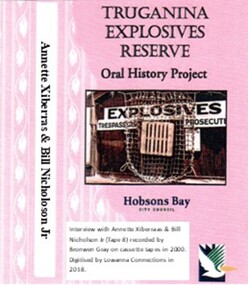 Truganina Explosives Reserve Preservation Society Inc (TERPS)
Digitised Oral History – Truganina Explosives Reserve - Tape 8 Annette Xibarras and Bill Nicholson Jnr, 2018
... The interviews were recorded in 2000 by Bronwen Gray and Alan Young for the production of Unreserved, Stories from Truganina Explosives Reserve, animated stories from past residents, workers and interested people of the Reserve (subject to copyright 2004). Annette Xibarras and Bill Nicholson Jnr discuss the indigenous significance of the Truganina Explosives Reserve. ...Truganina Explosives Reserve Preservation Society Inc (TERPS) 276 Queen Street Altona melbourne The interviews were recorded in 2000 by Bronwen Gray and Alan Young for the production of Unreserved, Stories from Truganina Explosives Reserve, animated stories from past residents, workers and interested people of the Reserve (subject to copyright 2004). Annette Xibarras and Bill Nicholson Jnr discuss the indigenous significance of the Truganina Explosives Reserve. ...The interviews were recorded in 2000 by Bronwen Gray and Alan Young for the production of Unreserved, Stories from Truganina Explosives Reserve, animated stories from past residents, workers and interested people of the Reserve (subject to copyright 2004). Annette Xibarras and Bill Nicholson Jnr discuss the indigenous significance of the Truganina Explosives Reserve. At the time of the interview Annette was the manager of the Kulin Nations Cultural Heritage Organisation. Bill, a Wurundjeri Elder, was a Wurundjeri Cultural Officer. They discussed their childhood, aboriginal customs, connection with the land and the locating of aboriginal remains at the Museum of Victoria and the re-burial at the site where they were found. A primary source of information on memories of the Truganina Explosives Reserve and Altona,VictoriaDigital copy of original cassette recorded in 2000 and digitised in 2018julia jones, princess balam balam, archaeological survey, middens, wurundjeri, kulin nations, coranderrk, braybrook, sacred sites, mt william, bunurong, museum victoria, altona, martha nicholson -
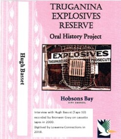 Truganina Explosives Reserve Preservation Society Inc (TERPS)
Digitised Oral History – Truganina Explosives Reserve - Tape 10 Hugh Basset, 2018
... As the then President of the Inner West Branch of the National Trust, Hugh was unaware of the Truganina Explosives Reserve until contacted by Nessie Hardy about the proposed sale of the site by the State Government. He was struck by the industrial, environment and indigenous significance of the site ...As the then President of the Inner West Branch of the National Trust, Hugh was unaware of the Truganina Explosives Reserve until contacted by Nessie Hardy about the proposed sale of the site by the State Government. He was struck by the industrial, environment and indigenous significance of the site A primary source of information on memories of the Truganina Explosives Reserve and Altona,Victoria Nessie Hardy Cheetham Salt Works migratory birds explosives reserve explosives Point Gellibrand National Trust tin fence sand ridges Altona Skipper Butterfly middens aboriginal occupation Judy Hindle Digital copy of original cassette recorded in 2000 and digitised in 2018 Digitised Oral History – Truganina Explosives Reserve - Tape 10 Hugh Basset ...The interviews were recorded in 2000 by Bronwen Gray and Alan Young for the production of Unreserved, Stories from Truganina Explosives Reserve, animated stories from past residents, workers and interested people of the Reserve (subject to copyright 2004). As the then President of the Inner West Branch of the National Trust, Hugh was unaware of the Truganina Explosives Reserve until contacted by Nessie Hardy about the proposed sale of the site by the State Government. He was struck by the industrial, environment and indigenous significance of the site A primary source of information on memories of the Truganina Explosives Reserve and Altona,VictoriaDigital copy of original cassette recorded in 2000 and digitised in 2018nessie hardy, cheetham salt works, migratory birds, explosives reserve, explosives, point gellibrand, national trust, tin fence, sand ridges, altona skipper butterfly, middens, aboriginal occupation, judy hindle -
 Uniting Church Archives - Synod of Victoria
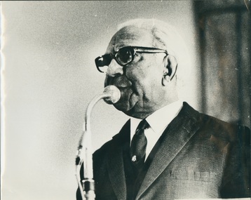
B&W photo of another photo or newspaper photograph of Pastor Sir Douglas Nicholls, Undated
... When the Welfare Board attempted to close Lake Tyers reserve, Gippsland, he resigned in disgust and led a protest march on parliament in May 1963. The AAL also petitioned the United Nations on land rights in June, perhaps the first indigenous body to do so. ...When the Welfare Board attempted to close Lake Tyers reserve, Gippsland, he resigned in disgust and led a protest march on parliament in May 1963. The AAL also petitioned the United Nations on land rights in June, perhaps the first indigenous body to do so. ...Sir Douglas Ralph Nicholls (1906-1988), footballer, pastor, activist and governor, was born on 9 December 1906 at Cummeragunja Aboriginal mission, New South Wales, fifth child of Herbert Nicholls, seasonal worker, and his wife Florence, née Atkinson. Doug grew up at Cummeragunja, on the Murray River near Barmah, in its golden years of Aboriginal autonomy. Thomas Shadrach James gave him and other Yorta Yorta children a sound primary education, reinforcing the pride and self-assurance gained from their parents. As Doug grew, so too did the powers of the State’s Aboriginal Protection Board. Doug’s elder sister Hilda was removed about 1915. When Doug reached 14, he was moved off under the Aborigines Protection Act (1909) to find work. He took a job with dredging teams constructing levees on the Murray. Like other youths in the region Nicholls played Australian rules football, emulating kinsmen who had won local premierships since the 1890s. Doug and his brother Herbert (‘Dowie’) played with Tongala in the mid-1920s. Melbourne football beckoned, Doug trying out unsuccessfully for Carlton in 1927. He signed with the Northcote Victorian Football Association team, despite his nervousness about his Aboriginality, and was given a job with Northcote City Council. ‘Dowie’ joined him for a season. Doug was short at 5 ft 2 ins (158 cm), but muscular and lightning fast. He competed regularly during a boom in professional running, winning many heat and place prizes. In 1929 he won the Nyah and Warracknabeal gifts, earning a sash and £100 in each, together with a case of cutlery in the latter. Using his speed on the wing for Northcote, he produced great spring and agility from his compact body. The Sporting Globe reported in 1929 that ‘he flashes through packs of big men, whisks around small men . . . and attempts marks at the back of any six-footer’. In front-on clashes he was flattened only to rise again. The sole Aborigine in the VFA, he was known affectionately as the ‘flying Abo’ but called worse by his opponents’ barrackers. He competed for five seasons, being named ‘best and fairest’ twice, appearing in three association grand finals and winning in 1929. Keen to earn more than a seasonal wage, in 1931 Nicholls accepted a three-year contract with Jimmy Sharman’s travelling boxing show. The bouts matched opposites, local against tent boxer, white against black, and sometimes men of different sizes. He faced stiff competition from those who wanted to best the noted Melbourne black footballer, the crowd adding racial abuse. A far better footballer than boxer, he copped some punishment. Fighting in the Melbourne Stadium in December 1931, he was described by Truth as ‘slow and awkward’, but packing a ‘good wallop’. In 1932 Sharman, who treated his boxers fairly, released Nicholls to join the Fitzroy Victorian Football League team, which agreed to employ him as its groundsman. He played fifty-four games for Fitzroy over six seasons until knee trouble forced him out in 1937. Winning cups in 1934 and 1935, he played alongside Haydn Bunton and Wilfred (‘Chicken’) Smallhorn. Grand finals eluded him but he represented Victoria twice. Following his mother’s death, Nicholls revisited the Church of Christ chapel in Northcote, where they had worshipped together. On 17 July 1932 he experienced a conversion. He was soon baptised and witnessed openly, leading his fellow footballers to occasional church parades. Nicholls exhibited leadership qualities. William Cooper, founder of the Australian Aborigines’ League and Nicholls’ Yorta Yorta kinsman and fellow Christian, encouraged the young footballer. In February 1935 Cooper, Nicholls and others lobbied Thomas Paterson, the Commonwealth minister for the interior, over the need for Federal control of Aboriginal affairs. Nicholls attended the Day of Mourning protest for Aborigines held in Sydney on 26 January 1938, declaring: ‘after 150 years our people are still influenced and bossed by white people. I know we can proudly hold our own with others if given the chance’. When Cooper retired in November 1940 Nicholls became secretary of the AAL. On 2 June 1941 Nicholls enlisted in the Citizen Military Forces. He trained at Seymour and Bonegilla before being posted to the 29th Battalion. As Major Frank Corr’s batman, he was popular with other soldiers who tolerated his preaching and Bible reading. His army service was brief, however, and he was discharged in Melbourne on compassionate grounds on 22 January 1942. His biographer claimed that the Fitzroy police requested his return to mediate in the racial tensions developing between servicemen and the mostly respectable Aboriginal families living in crowded and dilapidated Fitzroy housing; Aboriginal people maintain that they requested his release. Nicholls began welfare work and religious services from an Aboriginal home in Gertrude Street, Fitzroy. In April 1942, ‘Dowie’ died of road accident trauma, leaving his wife, Gladys, née Bux, and three children. On 26 December 1942 at Moama Methodist Church, New South Wales, Nicholls married her, a caring gesture which developed into a loving partnership. In January 1943 he initiated ‘Aboriginal Sunday’, featuring a gum leaf orchestra and choir. By 1955 this service had moved to July and later evolved into National Aborigines and Islanders Day Observance Committee (NAIDOC) week. Ordained a Churches of Christ pastor in 1945, Nicholls conducted a vigorous ministry from a chapel in Gore Street, Fitzroy. His work survived on donations, a small honorarium, and his employment as team coach (1947) and curator at the Northcote Football Ground. In the 1950s Gladys established grocery and opportunity shops to earn income and provide services. Their house soon overflowed with people in need or visitors to Melbourne. Nicholls also hosted inspiring African American visitors such as the pianist Winifred Attwell and the singer Harry Belafonte. His ministry extended to Aboriginal country communities. Gladys taught Sunday school, undertook endless fund-raising and welfare work beside her husband, and became his greatest supporter and financial manager. They formed an Aboriginal Girls’ Hostel in 1956, for which they acted as house parents, and bought holiday units for Aborigines at Queenscliff. Persistently advocating Aboriginal rights, Nicholls protested about the impact of the Woomera rocket range on the people of the Warburton Ranges, co-ordinated the production of a concert, Out of the Dark, scripted by Jean Campbell, to rectify the omission of Aborigines from Victoria’s Commonwealth jubilee celebrations, and criticised the Victorian Aboriginal Protection Board. In 1957 when the board was transformed into the Aborigines’ Welfare Board, he and Harold Blair were appointed as Aboriginal representatives. Maintaining the stance of a political moderate, he did not bear grudges and sought to build bridges between black and white. He co-operated with any group that aided the cause, including the Council of Aboriginal Rights, whose executive were members of the Communist Party of Australia. This association attracted the attention of the Australian Security Intelligence Organization, which in 1957 began to keep a file on Nicholls. In May 1957 Nicholls formed the Victorian Aborigines Advancement League with Doris Blackburn and Gordon Bryant, a Federal parliamentarian. As its paid field officer and spokesman, Nicholls contested assimilation policies and used film to raise awareness of issues. When the Welfare Board attempted to close Lake Tyers reserve, Gippsland, he resigned in disgust and led a protest march on parliament in May 1963. The AAL also petitioned the United Nations on land rights in June, perhaps the first indigenous body to do so. He argued for new premises at 58 Cunningham Street, Northcote, opened in 1966 as the ‘Doug Nicholls Centre’. In 1958 Nicholls was a foundation member of the Federal Council for Aboriginal Advancement (Federal Council for the Advancement of Aboriginal and Torres Strait Islanders after 1964), which he served as national field officer (1961) and Victorian secretary (1962-63). While an innovator in tactics, he was alarmed by the influence of confrontational ‘black power’ politics in the AAL and resigned as a director amid turmoil on this issue in 1969, claiming the concept was a ‘bitter word’, not needed in Australia. Similar tensions in FCAATSI led him to join with Kath Walker (Oodgeroo Noonuccal) in establishing the short-lived National Tribal Council as an alternative forum. As the AAL leadership moderated their stance, he returned as president (1969-74) of the new all-Aboriginal organisation. He was also a keen patron of the National Aboriginal Sports Foundation, founded in 1969. Many honours were conferred on Nicholls: he was appointed MBE (1957) and OBE (1968) and knighted (1972). In 1962 he was named Victorian ‘Father of the Year’ and the State’s second Aboriginal justice of the peace. Crowned Melbourne’s 1973 King of Moomba, he was declared Bapu Mamus (a Torres Strait term for ‘headman’) by the NTC. On 1 December 1976 Sir Douglas was appointed Governor of South Australia, but his health deteriorated within weeks, making it difficult for him to perform his official duties. In March 1977 he hosted Queen Elizabeth during her royal tour and was appointed KCVO. He relinquished his governorship on 30 April 1977 following a stroke. Ill health continued to dog him during retirement, but he played his Nelson Eddy records, enjoyed his expanding family, and when able, ministered to the Aboriginal Church at the League’s premises. Sir Douglas Nicholls died on 4 June 1988 at Mooroopna, predeceased (1981) by his wife and survived by his five children. He was given a state funeral and buried in tribal ground at Cummeragunja cemetery. Among the many tributes to him are an oval at Northcote, handed to the AAL in 1982, a Canberra suburb gazetted in 1991, and a fellowship for Indigenous leadership established in 2003, all in his name, and a statue of Sir Doug and Lady Nicholls by Louis Laumen, unveiled in 2007 in Parliament Gardens, Melbourne. Sir Douglas Nicholls is shown speaking at a microphone; head and shoulders; dressed in a suit.Pastor Douglas Nicholls -
 Eltham District Historical Society Inc
Journal - Newsletter, Nillumbik Shire Council, Nillumbik News, October 2000
... indigenous grass...environmental education...Open Space...public parkland...playgrounds...bike trail...Adventure Playground...community reserves...Kangaroo Ground Tower reserve...October 2000 articles include: Safer roads for the Shire Eltham Festival program announced Commercial Place design released 2000-2003 Council Plan Released National Reconciliation Framework Living and Learning Centres More Playgrounds Susan St Pavilion completed Study to plan for BMX/skate track Wattle Glen Township Strategy Community Weed Control Program Count Koala Day Environment Centre proposed for Edendale Farm Open Space Strategy findings Neighbourhood Character Study and Residential Design Guidelines Friends groups Clean Drains – Living Creeks, National Water Week Nillumbik Shire Council Cultural Plan 2000-2005 adopted 2001 Alan Marshall Short Story Award Artists’ Open Studios program Kangaroo Ground Tower Advisory Committee Environment leaders at Eltham North primary Dollars saved by regular road maintenance Regional Road upgrades Rural roads grading program Stormwater Management Plan Locality boundary update Council Newsletters Nillumbik News Nillumbik Shire Council Council Plan 2000–2003 Municipal Road Safety Strategy Infrastructure services Stormwater Management Plan Locality boundary review Rates Sustainable agriculture rebate Capital works program road maintenance Better Roads Victorian program eltham - yarra glen road Warrandyte - Kangaroo Ground Road Rural roads grading program Commercial Place Public space public infrastructrue meals on wheels Eltham Living and Learning Centre Living and Learning Centre adult community education volunteer programs Australia Day Awards community groups environmental protection sustainability Community weed control landcare koalas Drainage works waterway protection indigenous grass environmental education Open Space public parkland playgrounds bike trail Adventure Playground community reserves Kangaroo Ground Tower reserve Cultural plan Eltham festival Artists Open Studios cultural tourism Alan Marshall Short Story Award Montsalvat community arts program garden walks Eltham Fun Run community market mudbrick tours CERES Environmental Education Centre Nillumbik Tourism Association Food and Wine trail Yarra Valley Tourism campaign road safety Adrian Cully Alan Marshall Andrew Port Anne Connor Catherine Dale Chris Wallace-Crabbe Claire Harris David Scott David Yencken Dean Stewart Deb Ganderton Debra Wilkinson Denis Ward drew gregory Daryl Taylor Fiona Austin Frank Butters Frank Nolan Gavin Jordan Glen Jameson Grace Mitchell Greg Scott Harry Gilham Helen Ash Jane Annois jane viola Jan Kelly Jenneke Korteweg Jenni Mitchell Jessica Davison Jill Forrest john hewish Jules Burns Julius Peiker kay steventon Kayte Nunn Lesley Shuttleworth leslie Avril Louise Heathcote Marg Jeffery Margaret Jennings Martin Wright Mathew Hodsnesse Maurice Stabb Megan McCarthy Mervyn Hannan Michael Jansz michael skewes Mick Woiwod nel ten wolde Nicholas Pelling Ona Henderson Peter Burn Piers Bateman reg cox Reg Evans Robert Boyle Robert Hay Robert Theobald shan shnookal Sigmund Jorgensen Stuart Menzies Steven White Vonnie Frazer Eltham District Historical Society Council for Aboriginal Reconciliation Eltham North Primary School Wattle Glen Primary School Eltham Arts Council Churinga Arts Harvey World Travel (Eltham) Eltham Little Book Shop Do Lunch Cafe Volumes Cafe Grovedale Cottage Lovegrove Winery Cottles Bridge Yarrambat Golf Club Eltham Football Club Eltham Rugby Football Club Lower Eltham Cricket Club Susan Street Oval Syd Tunn Jack Rasterhoff A4. monotone print, double stapled, 4 pages Nillumbik News Journal Newsletter Nillumbik Shire Council ...The newsletter outlines local government initiatives, community events, environmental programs, infrastructure projects, and cultural activities occurring in the Nillumbik Shire around October–November 2000. It highlights council plans, community participation opportunities, and local developments aimed at improving quality of life in the region. October 2000 articles include: Safer roads for the Shire Eltham Festival program announced Commercial Place design released 2000-2003 Council Plan Released National Reconciliation Framework Living and Learning Centres More Playgrounds Susan St Pavilion completed Study to plan for BMX/skate track Wattle Glen Township Strategy Community Weed Control Program Count Koala Day Environment Centre proposed for Edendale Farm Open Space Strategy findings Neighbourhood Character Study and Residential Design Guidelines Friends groups Clean Drains – Living Creeks, National Water Week Nillumbik Shire Council Cultural Plan 2000-2005 adopted 2001 Alan Marshall Short Story Award Artists’ Open Studios program Kangaroo Ground Tower Advisory Committee Environment leaders at Eltham North primary Dollars saved by regular road maintenance Regional Road upgrades Rural roads grading program Stormwater Management Plan Locality boundary update council newsletters, nillumbik news, nillumbik shire council, council plan 2000–2003, municipal road safety strategy, infrastructure services, stormwater management plan, locality boundary review, rates, sustainable agriculture rebate, capital works program, road maintenance, better roads victorian program, eltham - yarra glen road, warrandyte - kangaroo ground road, rural roads grading program, commercial place, public space, public infrastructrue, meals on wheels, eltham living and learning centre, living and learning centre, adult community education, volunteer programs, australia day awards, community groups, environmental protection, sustainability, community weed control, landcare, koalas, drainage works, waterway protection, indigenous grass, environmental education, open space, public parkland, playgrounds, bike trail, adventure playground, community reserves, kangaroo ground tower reserve, cultural plan, eltham festival, artists open studios, cultural tourism, alan marshall short story award, montsalvat, community arts program, garden walks, eltham fun run, community market, mudbrick tours, ceres environmental education centre, nillumbik tourism association, food and wine trail, yarra valley tourism campaign, road safety, adrian cully, alan marshall, andrew port, anne connor, catherine dale, chris wallace-crabbe, claire harris, david scott, david yencken, dean stewart, deb ganderton, debra wilkinson, denis ward, drew gregory, daryl taylor, fiona austin, frank butters, frank nolan, gavin jordan, glen jameson, grace mitchell, greg scott, harry gilham, helen ash, jane annois, jane viola, jan kelly, jenneke korteweg, jenni mitchell, jessica davison, jill forrest, john hewish, jules burns, julius peiker, kay steventon, kayte nunn, lesley shuttleworth, leslie avril, louise heathcote, marg jeffery, margaret jennings, martin wright, mathew hodsnesse, maurice stabb, megan mccarthy, mervyn hannan, michael jansz, michael skewes, mick woiwod, nel ten wolde, nicholas pelling, ona henderson, peter burn, piers bateman, reg cox, reg evans, robert boyle, robert hay, robert theobald, shan shnookal, sigmund jorgensen, stuart menzies, steven white, vonnie frazer, eltham district historical society, council for aboriginal reconciliation, eltham north primary school, wattle glen primary school, eltham arts council, churinga arts, harvey world travel (eltham), eltham little book shop, do lunch cafe, volumes cafe, grovedale cottage, lovegrove winery cottles bridge, yarrambat golf club, eltham football club, eltham rugby football club, lower eltham cricket club, susan street oval, syd tunn, jack rasterhoff -
 Eltham District Historical Society Inc
Journal - Newsletter, Nillumbik Shire Council, Nillumbik News, October 2000
... indigenous grass...environmental education...Open Space...public parkland...playgrounds...bike trail...Adventure Playground...community reserves...Kangaroo Ground Tower reserve...October 2000 articles include: Safer roads for the Shire Eltham Festival program announced Commercial Place design released 2000-2003 Council Plan Released National Reconciliation Framework Living and Learning Centres More Playgrounds Susan St Pavilion completed Study to plan for BMX/skate track Wattle Glen Township Strategy Community Weed Control Program Count Koala Day Environment Centre proposed for Edendale Farm Open Space Strategy findings Neighbourhood Character Study and Residential Design Guidelines Friends groups Clean Drains – Living Creeks, National Water Week Nillumbik Shire Council Cultural Plan 2000-2005 adopted 2001 Alan Marshall Short Story Award Artists’ Open Studios program Kangaroo Ground Tower Advisory Committee Environment leaders at Eltham North primary Dollars saved by regular road maintenance Regional Road upgrades Rural roads grading program Stormwater Management Plan Locality boundary update Council Newsletters Nillumbik News Nillumbik Shire Council Council Plan 2000–2003 Municipal Road Safety Strategy Infrastructure services Stormwater Management Plan Locality boundary review Rates Sustainable agriculture rebate Capital works program road maintenance Better Roads Victorian program eltham - yarra glen road Warrandyte - Kangaroo Ground Road Rural roads grading program Commercial Place Public space public infrastructrue meals on wheels Eltham Living and Learning Centre Living and Learning Centre adult community education volunteer programs Australia Day Awards community groups environmental protection sustainability Community weed control landcare koalas Drainage works waterway protection indigenous grass environmental education Open Space public parkland playgrounds bike trail Adventure Playground community reserves Kangaroo Ground Tower reserve Cultural plan Eltham festival Artists Open Studios cultural tourism Alan Marshall Short Story Award Montsalvat community arts program garden walks Eltham Fun Run community market mudbrick tours CERES Environmental Education Centre Nillumbik Tourism Association Food and Wine trail Yarra Valley Tourism campaign road safety Adrian Cully Alan Marshall Andrew Port Anne Connor Catherine Dale Chris Wallace-Crabbe Claire Harris David Scott David Yencken Dean Stewart Deb Ganderton Debra Wilkinson Denis Ward drew gregory Daryl Taylor Fiona Austin Frank Butters Frank Nolan Gavin Jordan Glen Jameson Grace Mitchell Greg Scott Harry Gilham Helen Ash Jane Annois jane viola Jan Kelly Jenneke Korteweg Jenni Mitchell Jessica Davison Jill Forrest john hewish Jules Burns Julius Peiker kay steventon Kayte Nunn Lesley Shuttleworth leslie Avril Louise Heathcote Marg Jeffery Margaret Jennings Martin Wright Mathew Hodsnesse Maurice Stabb Megan McCarthy Mervyn Hannan Michael Jansz michael skewes Mick Woiwod nel ten wolde Nicholas Pelling Ona Henderson Peter Burn Piers Bateman reg cox Reg Evans Robert Boyle Robert Hay Robert Theobald shan shnookal Sigmund Jorgensen Stuart Menzies Steven White Vonnie Frazer Eltham District Historical Society Council for Aboriginal Reconciliation Eltham North Primary School Wattle Glen Primary School Eltham Arts Council Churinga Arts Harvey World Travel (Eltham) Eltham Little Book Shop Do Lunch Cafe Volumes Cafe Grovedale Cottage Lovegrove Winery Cottles Bridge Yarrambat Golf Club Eltham Football Club Eltham Rugby Football Club Lower Eltham Cricket Club Susan Street Oval Syd Tunn Jack Rasterhoff A4. two colour print (orange/blue), double stapled, 16 pages Nillumbik News Journal Newsletter Nillumbik Shire Council ...The newsletter outlines local government initiatives, community events, environmental programs, infrastructure projects, and cultural activities occurring in the Nillumbik Shire around October–November 2000. It highlights council plans, community participation opportunities, and local developments aimed at improving quality of life in the region. October 2000 articles include: Safer roads for the Shire Eltham Festival program announced Commercial Place design released 2000-2003 Council Plan Released National Reconciliation Framework Living and Learning Centres More Playgrounds Susan St Pavilion completed Study to plan for BMX/skate track Wattle Glen Township Strategy Community Weed Control Program Count Koala Day Environment Centre proposed for Edendale Farm Open Space Strategy findings Neighbourhood Character Study and Residential Design Guidelines Friends groups Clean Drains – Living Creeks, National Water Week Nillumbik Shire Council Cultural Plan 2000-2005 adopted 2001 Alan Marshall Short Story Award Artists’ Open Studios program Kangaroo Ground Tower Advisory Committee Environment leaders at Eltham North primary Dollars saved by regular road maintenance Regional Road upgrades Rural roads grading program Stormwater Management Plan Locality boundary update council newsletters, nillumbik news, nillumbik shire council, council plan 2000–2003, municipal road safety strategy, infrastructure services, stormwater management plan, locality boundary review, rates, sustainable agriculture rebate, capital works program, road maintenance, better roads victorian program, eltham - yarra glen road, warrandyte - kangaroo ground road, rural roads grading program, commercial place, public space, public infrastructrue, meals on wheels, eltham living and learning centre, living and learning centre, adult community education, volunteer programs, australia day awards, community groups, environmental protection, sustainability, community weed control, landcare, koalas, drainage works, waterway protection, indigenous grass, environmental education, open space, public parkland, playgrounds, bike trail, adventure playground, community reserves, kangaroo ground tower reserve, cultural plan, eltham festival, artists open studios, cultural tourism, alan marshall short story award, montsalvat, community arts program, garden walks, eltham fun run, community market, mudbrick tours, ceres environmental education centre, nillumbik tourism association, food and wine trail, yarra valley tourism campaign, road safety, adrian cully, alan marshall, andrew port, anne connor, catherine dale, chris wallace-crabbe, claire harris, david scott, david yencken, dean stewart, deb ganderton, debra wilkinson, denis ward, drew gregory, daryl taylor, fiona austin, frank butters, frank nolan, gavin jordan, glen jameson, grace mitchell, greg scott, harry gilham, helen ash, jane annois, jane viola, jan kelly, jenneke korteweg, jenni mitchell, jessica davison, jill forrest, john hewish, jules burns, julius peiker, kay steventon, kayte nunn, lesley shuttleworth, leslie avril, louise heathcote, marg jeffery, margaret jennings, martin wright, mathew hodsnesse, maurice stabb, megan mccarthy, mervyn hannan, michael jansz, michael skewes, mick woiwod, nel ten wolde, nicholas pelling, ona henderson, peter burn, piers bateman, reg cox, reg evans, robert boyle, robert hay, robert theobald, shan shnookal, sigmund jorgensen, stuart menzies, steven white, vonnie frazer, eltham district historical society, council for aboriginal reconciliation, eltham north primary school, wattle glen primary school, eltham arts council, churinga arts, harvey world travel (eltham), eltham little book shop, do lunch cafe, volumes cafe, grovedale cottage, lovegrove winery cottles bridge, yarrambat golf club, eltham football club, eltham rugby football club, lower eltham cricket club, susan street oval, syd tunn, jack rasterhoff -
 Stawell Historical Society Inc
Photograph, Indigenous or First Nations People at Carrs Plains 1874 Richardson River Tribe
... Indigenous or First Nation People outside a wood and bark hut. In 1861, William Dennis of Carrs Plains Station, a staunch Methodist became Honorary, Aboriginal Protector for the area. One of his main tasks to give Government supplied food and clothing to the Aboriginals. Many district, remaining First Nations People became based at Carrs Plains, and their dead were buried in a cemetery on the station. The cemetery is show on survey map of Wirchilleva Borough, in corner of camping & water reserve...Indigenous or First Nation People outside a wood and bark hut. In 1861, William Dennis of Carrs Plains Station, a staunch Methodist became Honorary, Aboriginal Protector for the area. One of his main tasks to give Government supplied food and clothing to the Aboriginals. Many district, remaining First Nations People became based at Carrs Plains, and their dead were buried in a cemetery on the station. The cemetery is show on survey map of Wirchilleva Borough, in corner of camping & water reserve ...Photo taken at Carrs Plains in 1874 of Indigenous or First Nation People outside a wood and bark hut. In 1861, William Dennis of Carrs Plains Station, a staunch Methodist became Honorary, Aboriginal Protector for the area. One of his main tasks to give Government supplied food and clothing to the Aboriginals. Many district, remaining First Nations People became based at Carrs Plains, and their dead were buried in a cemetery on the station. The cemetery is show on survey map of Wirchilleva Borough, in corner of camping & water reserve near surveyed Bismarck township. In a Protector's report 1869, Dennis wrote that only one male worked regularly on the property, a Bullock driver.Black and white photograph of a wood and bark hut with a group of men, women and children out the front. Richardson River Tribe.Anthony & Lubra, Donald & Affie my ? Herbal? Black Billie Great Rider, Kitty Supulants? Lubra Jonny Callaghan Jr., Four? Supulant? Harry, Blind Tommy & Lubra, 1874 Reproduction rights reserved Copied by State Library of Victoriastawell aboriginal portrait -
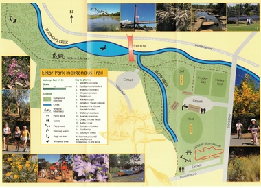 Whitehorse Historical Society Inc.
Pamphlet, Elgar Park Indigenous Trail
... indigenous trail...bushy creek reserve...parks and reserves elgar park indigenous trail bushy creek reserve greenlink box hill inc Pamphlet prepared by Greenlink Box Hill Inc Pamphlet prepared by Greenlink Box Hill Inc. about Elgar Park Indigenous Trail, Box Hill and Bushy Creek Indigenous Trail, Box Hill Elgar Park Indigenous Trail Pamphlet Pamphlet ...Pamphlet prepared by Greenlink Box Hill IncPamphlet prepared by Greenlink Box Hill Inc. about Elgar Park Indigenous Trail, Box Hill and Bushy Creek Indigenous Trail, Box HillPamphlet prepared by Greenlink Box Hill Incparks and reserves, elgar park indigenous trail, bushy creek reserve, greenlink box hill inc