Showing 2041 items matching "intersection"
-
 Buninyong & District Historical Society
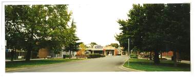
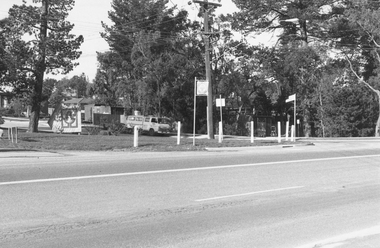
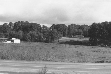
Photograph - Colour photograph of intersection of Warrenheip and Learmonth Streets Buninyong 1981, Intersection of Warrenheip and Learmonth Streets Buninyong 1981
... Intersection of Warrenheip and Learmonth Streets Buninyong 1981...Intersection of Warrenheip and Learmonth Streets Buninyong 1981...A colour photograph of the intersection of Warrenheip and Learmonth streets Buninyong in 1981...Buninyong & District Historical Society Old Court House, Buninyong Town Hall 313 Learmonth Street Buninyong goldfields Intersection of Warrenheip and Learmonth Streets Buninyong 1981 This photograph shows the intersection of Warrenheip and Learmonth Streets in 1981 prior to the construction of the roundabout Buninyong Streetscape Intersection of Warrenheip and Learmonth Streets 1981 February A colour photograph of the intersection of Warrenheip and Learmonth streets Buninyong in 1981 Intersection of Warrenheip and Learmonth Streets Buninyong 1981 Photograph Colour photograph of intersection of Warrenheip and Learmonth Streets Buninyong 1981 ...Intersection of Warrenheip and Learmonth Streets Buninyong 1981This photograph shows the intersection of Warrenheip and Learmonth Streets in 1981 prior to the construction of the roundaboutA colour photograph of the intersection of Warrenheip and Learmonth streets Buninyong in 19811981 Februarybuninyong, streetscape, intersection of warrenheip and learmonth streets -
 Emerald Museum & Nobelius Heritage Park
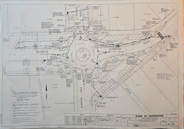
Map - Surveyors Map of new roundabout to be installed at the intersection of Belgrave-Gembrook Rd. and Kilvington Drive, Emerald 1988, Shire of Sherbrook, Roundabout at intersection of Belgrave-Gembrook Rd., and Kilvington Dve., Emerald, drawn 1988 - surveyors map, c1988
... Roundabout at intersection of Belgrave-Gembrook Rd., and Kilvington Dve., Emerald, drawn 1988 - surveyors map...Image of surveyors map outlining dimensions for new roundabout at the intersection of Belgrave-Gembrook Rd., and Kilvington Drive 1988.../Ferres Road/Kilvington Drive Intersection/Signed 13/8/88/Legend/Amendments/map.../Ferres Road/Kilvington Drive Intersection/Signed 13/8/88/Legend/Amendments/map Image of surveyors map outlining dimensions for new roundabout at the intersection of Belgrave-Gembrook Rd., and Kilvington Drive 1988 Roundabout at intersection of Belgrave-Gembrook Rd., and Kilvington Dve., Emerald, drawn 1988 - surveyors map Map Surveyors Map of new roundabout to be installed at the intersection of Belgrave-Gembrook Rd. and Kilvington Drive, Emerald 1988 Shire of Sherbrook ...Image of surveyors map outlining dimensions for new roundabout at the intersection of Belgrave-Gembrook Rd., and Kilvington Drive 1988non-fiction -
 Emerald Museum & Nobelius Heritage Park
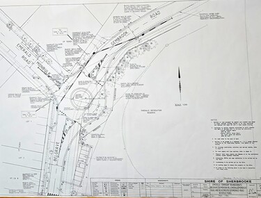
Map - Surveyors Map of new roundabout to be installed at the intersection of Belgrave-Gembrook Rd. and Emerald-Monbulk Rd., Emerald 1989, Shire of Sherbrook, Roundabout at intersection of Belgrave-Gembrook Rd., and Emerald Monbulk Rd., Emerald, drawn 1989 - surveyors map, c1989
... Roundabout at intersection of Belgrave-Gembrook Rd., and Emerald Monbulk Rd., Emerald, drawn 1989 - surveyors map...Image of surveyors map outlining dimensions for new roundabout at the intersection of Belgrave-Gembrook Rd., and Emerald-Monbulk Rd. 1989.../Emerald-Monbulk Rd., Intersection/Signed 4/1/89/Legend/Amendments/map.../Emerald-Monbulk Rd., Intersection/Signed 4/1/89/Legend/Amendments/map Image of surveyors map outlining dimensions for new roundabout at the intersection of Belgrave-Gembrook Rd., and Emerald-Monbulk Rd. 1989 Roundabout at intersection of Belgrave-Gembrook Rd., and Emerald Monbulk Rd., Emerald, drawn 1989 - surveyors map Map Surveyors Map of new roundabout to be installed at the intersection of Belgrave-Gembrook Rd. and Emerald-Monbulk Rd., Emerald 1989 Shire of Sherbrook ...Image of surveyors map outlining dimensions for new roundabout at the intersection of Belgrave-Gembrook Rd., and Emerald-Monbulk Rd. 1989non-fiction -
 Emerald Museum & Nobelius Heritage Park
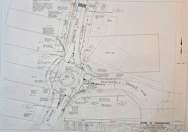
Map - Surveyors Map of new roundabout to be installed at the intersection of Belgrave-Gembrook Rd. and Beaconsfield-Emerald Rd., Emerald 1989, Shire of Sherbrook, Roundabout at intersection of Belgrave-Gembrook Rd., and Beaconsfield-Emerald Rd., Emerald, drawn 1989 - surveyors map, c1989
... Roundabout at intersection of Belgrave-Gembrook Rd., and Beaconsfield-Emerald Rd., Emerald, drawn 1989 - surveyors map...Image of surveyors map outlining dimensions for new roundabout at the intersection of Belgrave-Gembrook Rd., and Beaconsfield-Emerald Rd. 1989.../Beaconsfield-Emerald Road/Monbulk Rd. Intersections/Signed 4/1/89/Legend/Amendments/map.../Beaconsfield-Emerald Road/Monbulk Rd. Intersections/Signed 4/1/89/Legend/Amendments/map Image of surveyors map outlining dimensions for new roundabout at the intersection of Belgrave-Gembrook Rd., and Beaconsfield-Emerald Rd. 1989 Roundabout at intersection of Belgrave-Gembrook Rd., and Beaconsfield-Emerald Rd., Emerald, drawn 1989 - surveyors map Map Surveyors Map of new roundabout to be installed at the intersection of Belgrave-Gembrook Rd. and Beaconsfield-Emerald Rd., Emerald 1989 Shire of Sherbrook ...Image of surveyors map outlining dimensions for new roundabout at the intersection of Belgrave-Gembrook Rd., and Beaconsfield-Emerald Rd. 1989non-fiction -
 Tatura Irrigation & Wartime Camps Museum
Photograph, Intersection Frances and Hogan Street, Tatura
... Intersection Frances and Hogan Street, Tatura...Shows picture of the intersection of Francis and Hogan Streets, Tatura. ...Colour photograph showing the intersection of Francis and Hogan Streets, Tatura. ...Tatura Irrigation & Wartime Camps Museum 49 Hogan Street Tatura the-murray Shows picture of the intersection of Francis and Hogan Streets, Tatura. hogan street tatura francis street tatura Colour photograph showing the intersection of Francis and Hogan Streets, Tatura. ...Shows picture of the intersection of Francis and Hogan Streets, Tatura. Colour photograph showing the intersection of Francis and Hogan Streets, Tatura. Photograph stuck onto piece of white cardboard. hogan street tatura, francis street tatura -
 Buninyong & District Historical Society
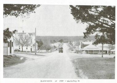
Photograph - Photo of Original Photograph, Warrenheip / Learmonth intersection, looking north up Warrenheip, in 1958, 1995
... Warrenheip / Learmonth intersection, looking north up Warrenheip, in 1958......intersection...B/W photograph, Warrenheip / Learmonth intersection, looking north up Warrenheip, in 1958, Crown Hotel, corner store visible, truck with double layer load of cars heading north....Warrenheip St. intersection Crown Hotel Corner Store "Specially Produced For A.H. ...historic streetscapeB/W photograph, Warrenheip / Learmonth intersection, looking north up Warrenheip, in 1958, Crown Hotel, corner store visible, truck with double layer load of cars heading north."Specially Produced For A.H. Dixon Learmonth St, from east, Buninyong 1543"buninyong, learmonth st., warrenheip st., intersection, crown hotel, corner store -
 Tatura Irrigation & Wartime Camps Museum
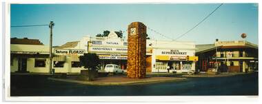
Photograph, Clock Tower intersection, Hogan Street, Tatura
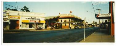
... Clock Tower intersection, Hogan Street, Tatura...Shows picture of businesses at the Clock Tower intersection, Hogan Street, Tatura,....Colour photograph showing intersection where the Clock Tower is located in Hogan Street, Tatura. ...Tatura Irrigation & Wartime Camps Museum 49 Hogan Street Tatura the-murray Shows picture of businesses at the Clock Tower intersection, Hogan Street, Tatura,. hogan street tatura criterion hotel tatura max's supermarket tatura tatura handyman's hardware tatura florist tatura post office Colour photograph showing intersection where the Clock Tower is located in Hogan Street, Tatura. ...Shows picture of businesses at the Clock Tower intersection, Hogan Street, Tatura,.Colour photograph showing intersection where the Clock Tower is located in Hogan Street, Tatura. Photograph stuck onto piece of white cardboard. hogan street tatura, criterion hotel tatura, max's supermarket tatura, tatura handyman's hardware, tatura florist, tatura post office -
 Buninyong & District Historical Society
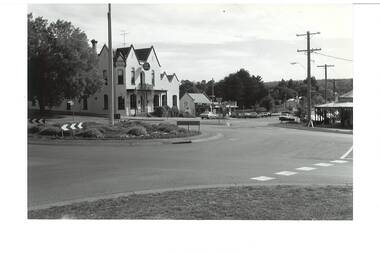
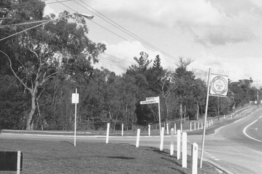
Photograph - B/W photograph, Roundabout - intersection of Learmonth and Warrenheip Streets Buninyong. Background Crown Hotel, 1995
... Roundabout - intersection of Learmonth and Warrenheip Streets Buninyong. ...Shows major intersection in mid 1990's. ...B/W photograph of intersection of Learmonth and Warrenheip Streets Buninyong. ...Buninyong & District Historical Society Old Court House, Buninyong Town Hall 313 Learmonth Street Buninyong goldfields Shows major intersection in mid 1990's. Record of intersection in mid 1990's Buninyong streeetscape buiulding Crown Hotel corner shop B/W photograph of intersection of Learmonth and Warrenheip Streets Buninyong. ...Shows major intersection in mid 1990's. Record of intersection in mid 1990'sB/W photograph of intersection of Learmonth and Warrenheip Streets Buninyong. Crown Hotel centre background, bottle shop next door, and corner shop visible on right.buninyong, streeetscape, buiulding, crown hotel, corner shop -
 Tatura Irrigation & Wartime Camps Museum
Photograph, Clock Tower intersection, Hogan Street, Tatura
... Clock Tower intersection, Hogan Street, Tatura...Shows picture of businesses at the Clock Tower intersection, Hogan Street, Tatura. Looking east along Hogan Street....Colour photograph showing businesses at the intersection just up from where the Clock Tower is located in Hogan Street, Tatura. ...Photograph stuck onto piece of white cardboard. Clock Tower intersection, Hogan Street, Tatura Photograph Photograph ...Shows picture of businesses at the Clock Tower intersection, Hogan Street, Tatura. Looking east along Hogan Street.Colour photograph showing businesses at the intersection just up from where the Clock Tower is located in Hogan Street, Tatura. Photograph stuck onto piece of white cardboard. hogan street tatura, criterion hotel tatura, max's supermarket tatura, tatura handyman's hardware, tatura post office, tatura butcher -
 Ringwood and District Historical Society
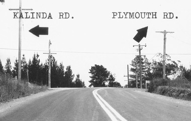
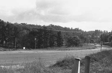
Photograph, Intersection of Kalinda Road and Plymouth Rd. Ringwood 1967
... Intersection of Kalinda Road and Plymouth Rd. Ringwood 1967...Catalogue card reads, "Intersection of Kalinda Road and Plymouth Rd. 1967"....Ringwood and District Historical Society 125A Warrandyte Road Ringwood North melbourne Catalogue card reads, "Intersection of Kalinda Road and Plymouth Rd. 1967". ...B&W Photograph with road names and arrows added.Catalogue card reads, "Intersection of Kalinda Road and Plymouth Rd. 1967". -
 Tarnagulla History Archive
News clipping: Notorious Intersection Claims Three Lives, Notorious Intersection Claims Three Lives, September 8, 1981
... Notorious Intersection Claims Three Lives...A single page of The Advertiser (Maryborough) newspaper of September 8, 1981 with article titled 'Notorious Intersection Claims Three Lives' relating to intersection at Laanecoorie. ...Notorious Intersection Claims Three Lives News clipping: Notorious Intersection Claims Three Lives ...Murray Comrie Collection. A single page of The Advertiser (Maryborough) newspaper of September 8, 1981 with article titled 'Notorious Intersection Claims Three Lives' relating to intersection at Laanecoorie. laanecoorie, accidents, collisions, roads, driving, transport -
 Ringwood and District Historical Society
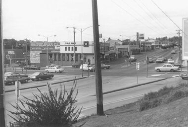
Photograph, Maroondah Highway East, Ringwood- 1976. Looking east from Warrandyte Road intersection
... Looking east from Warrandyte Road intersection....Image shows intersection with C.B.A. Bank on north east corner. ...Looking east from Warrandyte Road intersection. Photograph ...Black and white photographImage shows intersection with C.B.A. Bank on north east corner. Photograph taken mid 1976. -
 Ringwood and District Historical Society
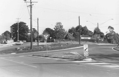
Photograph, Intersection Smedley Rd. (right) and Oban Road, North Ringwood. 1981
... Intersection Smedley Rd. (right) and Oban Road, North Ringwood. 1981...Written on back of photograph, "18/4/81. Intersection Smedley Rd. (right) and Oban Road."...Intersection Smedley Rd. (right) and Oban Road, North Ringwood. 1981 Photograph ...Written on back of photograph, "18/4/81. Intersection Smedley Rd. (right) and Oban Road." -
 Buninyong & District Historical Society
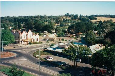
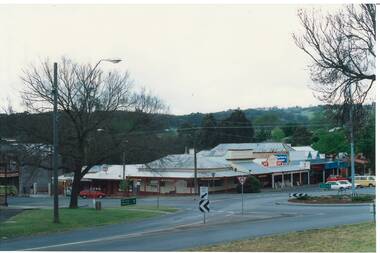
Photograph - Aerial Colour photograph Feb.1997, intersection Warrenheip and Learmonth Streets, Aerial photograph Feb.1997, intersection Warrenheip and Learmonth Streets
... Aerial photograph Feb.1997, intersection Warrenheip and Learmonth Streets...Aerial photograph Feb.1997, intersection Warrenheip and Learmonth Streets...buildings, festival Gold King Festival Corner Warrenheip and Learmonth Aerial photograph Feb.1997, intersection Warrenheip and Learmonth Streets Aerial photograph Feb.1997, intersection Warrenheip and Learmonth Streets Photograph Aerial Colour photograph Feb.1997, intersection Warrenheip and Learmonth Streets ...buildings, festivalAerial photograph Feb.1997, intersection Warrenheip and Learmonth Streetsgold king festival, corner warrenheip and learmonth -
 Ringwood and District Historical Society
Photograph, Intersection of Tortice Drive, Old Warrandyte Road and Warrandyte Road 1981
... Intersection of Tortice Drive, Old Warrandyte Road and Warrandyte Road 1981...Written on back of photograph, "19/6/81. Intersection of Tortice Drive, Old Warrandyte Road and Warrandyte Road."...Intersection of Tortice Drive, Old Warrandyte Road and Warrandyte Road 1981 Photograph ...Written on back of photograph, "19/6/81. Intersection of Tortice Drive, Old Warrandyte Road and Warrandyte Road." -
 Ringwood and District Historical Society
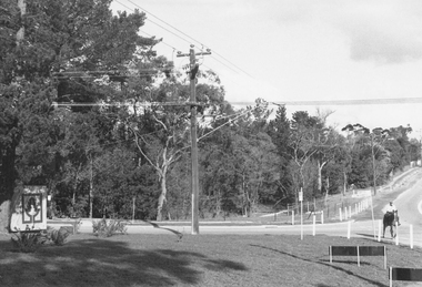
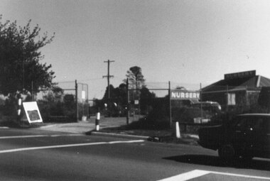
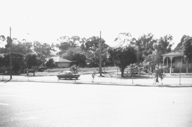
Photograph, Nursery on north-west corner of intersection of Warrandyte and Oban Roads. North Ringwood 1981
... Nursery on north-west corner of intersection of Warrandyte and Oban Roads. North Ringwood 1981...Nursery on north-west corner of intersection of Warrandyte and Oban Roads"....Nursery on north-west corner of intersection of Warrandyte and Oban Roads". Nursery on north-west corner of intersection of Warrandyte and Oban Roads. ...Written on back of photograph, "18/4/81. Nursery on north-west corner of intersection of Warrandyte and Oban Roads". -
 Ringwood and District Historical Society
Photograph, Intersection of Warrandyte Road and Oban Road, North Ringwood. Looking south-east. 1981
... Intersection of Warrandyte Road and Oban Road, North Ringwood. ...Written on back of photograph, "18/4/81. Intersection of Warrandyte Road and Oban Road. ...Looking south-east". Intersection of Warrandyte Road and Oban Road, North Ringwood. ...Written on back of photograph, "18/4/81. Intersection of Warrandyte Road and Oban Road. Looking south-east". -
 Ringwood and District Historical Society
Photograph, Intersection of Tortice Dr. Old Warrandyte Rd. and Warrandyte Road 1981
... Intersection of Tortice Dr. Old Warrandyte Rd. and Warrandyte Road 1981...Written on back of photograph, "19/6/81. Intersection of Tortice Dr. Old Warrandyte Rd. and Warrandyte Road (in foreground)."...Intersection of Tortice Dr. Old Warrandyte Rd. and Warrandyte Road 1981 Photograph ...Written on back of photograph, "19/6/81. Intersection of Tortice Dr. Old Warrandyte Rd. and Warrandyte Road (in foreground)." -
 Ringwood and District Historical Society
Photograph, Intersection of Tortice Dr. Old Warrandyte Road and Warrandyte Road 1981
... Intersection of Tortice Dr. Old Warrandyte Road and Warrandyte Road 1981...Written on back of photograph, "19/6/81. Intersection of Tortice Dr. Old Warrandyte Road and Warrandyte Road (on right)."...Intersection of Tortice Dr. Old Warrandyte Road and Warrandyte Road 1981 Photograph ...Written on back of photograph, "19/6/81. Intersection of Tortice Dr. Old Warrandyte Road and Warrandyte Road (on right)." -
 Ringwood and District Historical Society
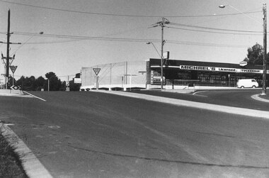
Photograph, Warrandyte Road from east corner of Oban Rd. intersection. North Ringwood 1981
... Warrandyte Road from east corner of Oban Rd. intersection. North Ringwood 1981...Warrandyte Road from north-east corner of Oban Rd. intersection"....Warrandyte Road from north-east corner of Oban Rd. intersection". Warrandyte Road from east corner of Oban Rd. intersection. ...Written on back of photograph, "18/4/81. Warrandyte Road from north-east corner of Oban Rd. intersection". -
 Buninyong & District Historical Society
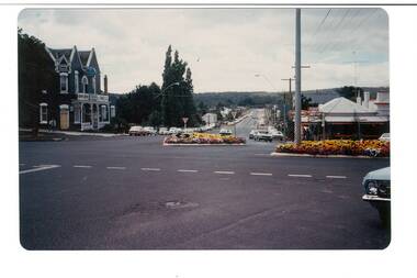
Photograph - Original Photograph, Intersection of Learmonth and Warrenheip Sts. in 9 November 1991
... Intersection of Learmonth and Warrenheip Sts. ...Colour photo of Intersection of Learmonth and Warrenheip Sts. 9 November 1991, from S.W. corner....Intersection of Learmonth and Warrenheip Sts. in 9 November 1991 Photograph Original Photograph ...State of building in 1991Colour photo of Intersection of Learmonth and Warrenheip Sts. 9 November 1991, from S.W. corner.buninyong, roundabout, corner shop, -
 Ringwood and District Historical Society
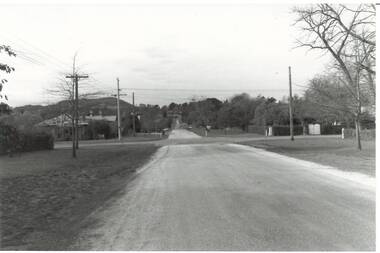
Photograph, Warrandyte Road looking west from intersection with Old Warrandyte Road and Tortice Drive 1981
... Warrandyte Road looking west from intersection with Old Warrandyte Road and Tortice Drive 1981...Warrandyte Road looking west from intersection with Old Warrandyte Road and Tortice Drive."...Warrandyte Road looking west from intersection with Old Warrandyte Road and Tortice Drive." ...Written on back of photograph, "19/7/81. Warrandyte Road looking west from intersection with Old Warrandyte Road and Tortice Drive." -
 Ringwood and District Historical Society
Photograph, Intersection of Wonga and Oban Roads 1981
... Intersection of Wonga and Oban Roads 1981...Written on back of photograph, "20.6.81. Intersection of Wonga and Oban Roads. Oban Road crossing left to right centre. ...Wonga Road on Right." Intersection of Wonga and Oban Roads 1981 Photograph ...Written on back of photograph, "20.6.81. Intersection of Wonga and Oban Roads. Oban Road crossing left to right centre. Wonga Road on Right." -
 Ringwood and District Historical Society
Photograph, "Intersection of Warrandyte Rd. and Aird Street. Lindsay's old home on corner on right-hand side 1978
... "Intersection of Warrandyte Rd. and Aird Street. ...Written on back of photograph, "Intersection of Warrandyte Rd. and Aird Street. ...Lindsay's old home on corner on right-hand side." 05/1978 "Intersection of Warrandyte Rd. and Aird Street. ...Written on back of photograph, "Intersection of Warrandyte Rd. and Aird Street. Lindsay's old home on corner on right-hand side." 05/1978 -
 Buninyong & District Historical Society
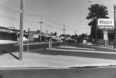
Photograph - Original B/W Photograph, Scott St looking east from intersection with Warrenheip St, 19th July 1993
... Scott St looking east from intersection with Warrenheip St...Original B/W photo of Scott St looking east from its intersection with Warrenheip St....Scott St Warrenheip St Streetscape Mount Buninyong Original B/W photo of Scott St looking east from its intersection with Warrenheip St. Scott St looking east from intersection with Warrenheip St Photograph Original B/W Photograph ...Scott St was originally an alternative cart track down from Mt. Buninyong.This streetscape is of historic and social significance.Original B/W photo of Scott St looking east from its intersection with Warrenheip St.scott st, warrenheip st, streetscape, mount buninyong -
Whitehorse Historical Society Inc.
Map, Boronia Road, Canterbury Road intersection, c1970
... Boronia Road, Canterbury Road intersection...Enlarged aerial photograph of the intersection of Canterbury and Boronia Roads. ...Boronia Road, Canterbury Road intersection Map Map ...Enlarged aerial photograph of the intersection of Canterbury and Boronia Roads. State Aerial Survey, Melbourne 1970 project.Enlarged aerial photograph of the intersection of Canterbury and Boronia Roads. State Aerial Survey, Melbourne 1970 project.Enlarged aerial photograph of the intersection of Canterbury and Boronia Roads. State Aerial Survey, Melbourne 1970 project.boronia road, vermont, canterbury road, vermont, mitcham road, vermont, frances avenue, vermont, nurlendi road, vermont, beaumont street, vermont, kingsclere street, vermont, webb court, vermont, aerial photographs -
 Ringwood and District Historical Society
Photograph, Intersection of Warrandyte Road with Old Warrandyte Road and Tortice Dr. 1981
... Intersection of Warrandyte Road with Old Warrandyte Road and Tortice Dr. 1981...Looking south-west from intersection of Warrandyte Road with Old Warrandyte Road and Tortice Dr."...Looking south-west from intersection of Warrandyte Road with Old Warrandyte Road and Tortice Dr." ...Written on back of photograph, "19/6/81. Looking south-west from intersection of Warrandyte Road with Old Warrandyte Road and Tortice Dr." -
 Ringwood and District Historical Society
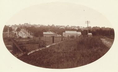
Postcard, View of Ringwood looking East from Warrandyte Road /Whitehorse Road intersection. Circa 1916
... View of Ringwood looking East from Warrandyte Road /Whitehorse Road intersection. Circa 1916..."Written on back of Postcard" View of Ringwood looking East from Warrandyte Road/Whitehorse Road intersection. Circa 1916. Presbyterian Church in foreground...Ringwood and District Historical Society 125A Warrandyte Road Ringwood North melbourne "Written on back of Postcard" View of Ringwood looking East from Warrandyte Road/Whitehorse Road intersection. Circa 1916. Presbyterian Church in foreground Sepia photograph on front of Postcard View of Ringwood looking East from Warrandyte Road /Whitehorse Road intersection. ...Sepia photograph on front of Postcard"Written on back of Postcard" View of Ringwood looking East from Warrandyte Road/Whitehorse Road intersection. Circa 1916. Presbyterian Church in foreground -
 Whitehorse Historical Society Inc.
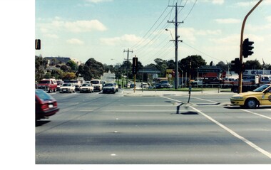
Photograph - Coloured photograph, Forest Hill Intersection| Canterbury and Springvale Roads
... Forest Hill Intersection| Canterbury and Springvale Roads...Coloured photograph of the intersection. Springvale Road in the foreground. ...Whitehorse Historical Society Inc. 2-10 Deep Creek Road Mitcham melbourne Canterbury Road Springvale Road Forest Hill Coloured photograph of the intersection. Springvale Road in the foreground. ...Coloured photograph of the intersection. Springvale Road in the foreground. Canterbury Road heading toward Forest Hill Chase Shopping Centre.canterbury road, springvale road forest hill -
 Buninyong & District Historical Society
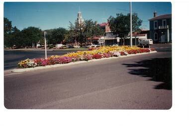
Photograph - Colour photo, intersection Warrenheip and Learmonth Rds. during Gold King Festival, 1981, Intersection Warrenheip and Learmonth Rds. Buninyong, Gold King Festival, 1981
... Intersection Warrenheip and Learmonth Rds. Buninyong, Gold King Festival, 1981...Colour photo, Intersection Warrenheip and Learmonth Rds. Buninyong, Gold King Festival, 1981, showing garden beds in traffic islands...Buninyong & District Historical Society Old Court House, Buninyong Town Hall 313 Learmonth Street Buninyong goldfields Events, buildings Gold King Festival Corner Warrenheip and Learmonth Colour photo, Intersection Warrenheip and Learmonth Rds. Buninyong, Gold King Festival, 1981, showing garden beds in traffic islands Intersection Warrenheip and Learmonth Rds. ...Events, buildingsColour photo, Intersection Warrenheip and Learmonth Rds. Buninyong, Gold King Festival, 1981, showing garden beds in traffic islandsgold king festival, corner warrenheip and learmonth