Showing 122 items matching "iron roofing"
-
 Flagstaff Hill Maritime Museum and Village
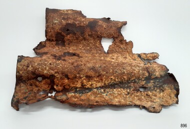
Functional object - Corrugated Iron, Barclay Curle & Co shipbuilders, 1873
... ...iron roofing...Through is associated with the worst and best-known shipwreck in Victoria's history. flagstaff hill warrnambool flagstaff hill maritime museum shipwreck coast flagstaff hill maritime village great ocean road loch line loch ard captain gibbs eva carmichael tom pearce glenample station mutton bird island loch ard gorge corrugated iron Loch Ard Artifact building material iron roofing None Sheet of corrugated iron, rusted, corroded and holed, recovered from the wreck of the Loch Ard Functional object Corrugated Iron Barclay Curle & Co shipbuilders ...The Loch Ard got its name from ”Loch Ard” a loch which lies to the west of Aberfoyle, and the east of Loch Lomond. It means "high lake" in Scottish Gaelic. The vessel belonged to the famous Loch Line which sailed many vessels from England to Australia. The Loch Ard was built in Glasgow by Barclay, Curdle and Co. in 1873, the vessel was a three-masted square-rigged iron sailing ship that measured 79.87 meters in length, 11.58 m in width, and 7 m in depth with a gross tonnage of 1693 tons with a mainmast that measured a massive 45.7 m in height. Loch Ard made three trips to Australia and one trip to Calcutta before its fateful voyage. Loch Ard left England on March 2, 1878, under the command of 29-year-old Captain Gibbs, who was newly married. The ship was bound for Melbourne with a crew of 37, plus 17 passengers. The general cargo reflected the affluence of Melbourne at the time. Onboard were straw hats, umbrella, perfumes, clay pipes, pianos, clocks, confectionery, linen and candles, as well as a heavier load of railway irons, cement, lead and copper. There were other items included that were intended for display in the Melbourne International Exhibition of 1880. The voyage to Port Phillip was long but uneventful. Then at 3 am on June 1, 1878, Captain Gibbs was expecting to see land. But the Loch Ard was running into a fog which greatly reduced visibility. Captain Gibbs was becoming anxious as there was no sign of land or the Cape Otway lighthouse. At 4 am the fog lifted and a lookout aloft announced that he could see breakers. The sheer cliffs of Victoria's west coast came into view, and Captain Gibbs realised that the ship was much closer to them than expected. He ordered as much sail to be set as time would permit and then attempted to steer the vessel out to sea. On coming head-on into the wind, the ship lost momentum, the sails fell limp and Loch Ard's bow swung back towards land. Gibbs then ordered the anchors to be released in an attempt to hold its position. The anchors sank some 50 fathoms - but did not hold. By this time the ship was among the breakers and the tall cliffs of Mutton Bird Island rose behind. Just half a mile from the coast, the ship's bow was suddenly pulled around by the anchor. The captain tried to tack out to sea, but the ship struck a reef at the base of Mutton Bird Island, near Port Campbell. Waves subsequently broke over the ship and the top deck became loosened from the hull. The masts and rigging came crashing down knocking passengers and crew overboard. When a lifeboat was finally launched, it crashed into the side of Loch Ard and capsized. Tom Pearce, who had launched the boat, managed to cling to its overturned hull and shelter beneath it. He drifted out to sea and then on the flood tide came into what is now known as Lochard Gorge. He swam to shore, bruised and dazed, and found a cave in which to shelter. Some of the crew stayed below deck to shelter from the falling rigging but drowned when the ship slipped off the reef into deeper water. Eva Carmichael a passenger had raced onto the deck to find out what was happening only to be confronted by towering cliffs looming above the stricken ship. In all the chaos, Captain Gibbs grabbed Eva and said, "If you are saved Eva, let my dear wife know that I died like a sailor". That was the last Eva Carmichael saw of the captain. She was swept off the ship by a huge wave. Eva saw Tom Pearce on a small rocky beach and yelled to attract his attention. He dived in and swam to the exhausted woman and dragged her to shore. He took her to the cave and broke the open case of brandy which had washed up on the beach. He opened a bottle to revive the unconscious woman. A few hours later Tom scaled a cliff in search of help. He followed hoof prints and came by chance upon two men from nearby Glenample Station three and a half miles away. In a complete state of exhaustion, he told the men of the tragedy. Tom then returned to the gorge while the two men rode back to the station to get help. By the time they reached Loch Ard Gorge, it was cold and dark. The two shipwreck survivors were taken to Glenample Station to recover. Eva stayed at the station for six weeks before returning to Ireland by steamship. In Melbourne, Tom Pearce received a hero's welcome. He was presented with the first gold medal of the Royal Humane Society of Victoria and a £1000 cheque from the Victorian Government. Concerts were performed to honour the young man's bravery and to raise money for those who lost family in the disaster. Of the 54 crew members and passengers on board, only two survived: the apprentice, Tom Pearce and the young woman passenger, Eva Carmichael, who lost her family in the tragedy. Ten days after the Lochard tragedy, salvage rights to the wreck were sold at auction for £2,120. Cargo valued at £3,000 was salvaged and placed on the beach, but most washed back into the sea when another storm developed. The wreck of Lochard still lies at the base of Mutton Bird Island. Much of the cargo has now been salvaged and some items were washed up into Lochard Gorge. Cargo and artefacts have also been illegally salvaged over many years before protective legislation was introduced in March 1982. One of the most unlikely pieces of cargo to have survived the shipwreck was a Minton majolica peacock- one of only nine in the world. The peacock was destined for the Melbourne 1880 International Exhibition in. It had been well packed, which gave it adequate protection during the violent storm. Today the Minton peacock can be seen at the Flagstaff Hill Maritime Museum in Warrnambool. From Australia's most dramatic shipwreck it has now become Australia's most valuable shipwreck artifact and is one of very few 'objects' on the Victorian State Heritage Register. The shipwreck of the Loch Ard is of significance for Victoria and is registered on the Victorian Heritage Register ( S 417). Flagstaff Hill has a varied collection of artefacts from Loch Ard and its collection is significant for being one of the largest accumulation of artefacts from this notable Victorian shipwreck of which the subject items are a small part. The collections objects give us a snapshot of how we can interpret the story of this tragic event. The collection is also archaeologically significant as it represents aspects of Victoria's shipping history that allows us to interpret Victoria's social and historical themes of the time. Through is associated with the worst and best-known shipwreck in Victoria's history.Sheet of corrugated iron, rusted, corroded and holed, recovered from the wreck of the Loch ArdNoneflagstaff hill, warrnambool, flagstaff hill maritime museum, shipwreck coast, flagstaff hill maritime village, great ocean road, loch line, loch ard, captain gibbs, eva carmichael, tom pearce, glenample station, mutton bird island, loch ard gorge, corrugated iron, loch ard artifact, building material, iron roofing -
 Victorian Interpretive Projects Inc.
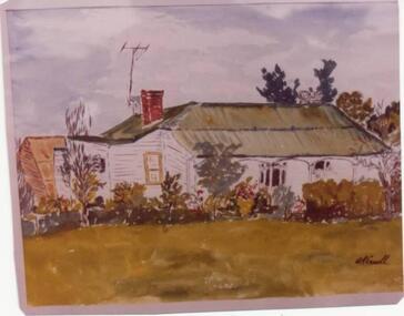
Photograph - colour, Clare Gervasoni, House with shingle roof in Lydiard (North) Street, Ballarat, 2014, 18/01/2015
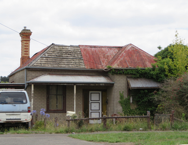
... Colour photograph of a clad weatherboard house in Lydiard (North) Street Ballarat. Some of the iron roofing has been removed exposing shingles....PO Box 93R, Redan, 3350 goldfields Although this house has been clad and had an iron roof put onto it, the historical integrity still appears to be intact. weatherboard shingles lydiard street house Colour photograph of a clad weatherboard house in Lydiard (North) Street Ballarat. Some of the iron roofing has been removed exposing shingles. ...Although this house has been clad and had an iron roof put onto it, the historical integrity still appears to be intact. Colour photograph of a clad weatherboard house in Lydiard (North) Street Ballarat. Some of the iron roofing has been removed exposing shingles.weatherboard, shingles, lydiard street, house -
 Glenelg Shire Council Cultural Collection
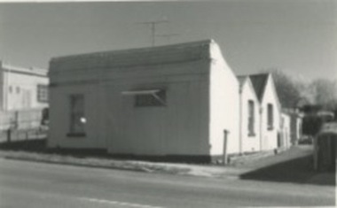
Photograph - Photograph - construction site, Portland, 1960s
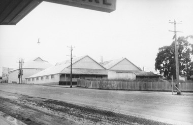
... The foreground structure is in the ground, and in the background is a shed-like structure with corrugated iron roofing. Grain terminal under construction...The foreground structure is in the ground, and in the background is a shed-like structure with corrugated iron roofing. Grain terminal under construction Photograph Photograph - construction site, Portland ...Port of Portland Authority archivesFront: (no inscriptions) Back: (no inscriptions)port of portland archives, construction -
 Ringwood and District Historical Society
Photograph, Ringwood Cool Stores Corner Main St. and Wantirna Rd1958
... Photographs shows wooden buildings with gently sloping peaked corrugated iron roofing. Picket fence at front of building with "Vote NO" painted....Photographs shows wooden buildings with gently sloping peaked corrugated iron roofing. Picket fence at front of building with "Vote NO" painted. ...Black and white photograph of Ringwood Cool Stores. Photographs shows wooden buildings with gently sloping peaked corrugated iron roofing. Picket fence at front of building with "Vote NO" painted.Typed below photograph, "Ringwood Cool Stores. Present site of Ringwood Clock Tower, 1958". Written on backing sheet, "Cool Store 1958. Corner Main St. and Wantirna Rd. Now site of Clock Tower". -
 Halls Gap & Grampians Historical Society
Photograph - B/W, C 1989
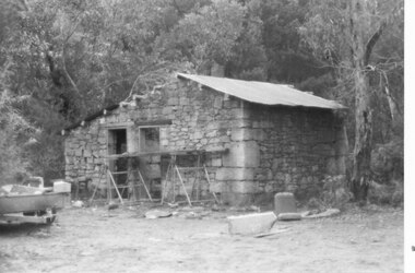
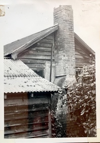
... Photo shows a stone cottage with two doors. There is iron roofing on the left hand side of the cottage and on the right hand side the roof is missing. ...BUILDINGS Houses QUARRYING Heatherlie Photo shows a stone cottage with two doors. There is iron roofing on the left hand side of the cottage and on the right hand side the roof is missing. ...Photo shows stone mason's cottage at Heatherlie Quarry under renovation.Photo shows a stone cottage with two doors. There is iron roofing on the left hand side of the cottage and on the right hand side the roof is missing. There is scaffolding at the front of the cottage. A trailer can be seen on the left.buildings, houses, quarrying, heatherlie -
 Sunbury Family History and Heritage Society Inc.
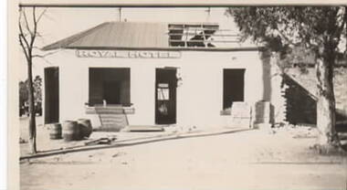
Photograph, The Royal Hotel, 1936
... The doors and windows have been removed as well a portion of the iron roofing. Three empty barrels are stacked by the doorway. ...The doors and windows have been removed as well a portion of the iron roofing. Three empty barrels are stacked by the doorway. ...The single storey Royal Hotel was built on the SE corner of Brook and Evans Street in 1861, two years after a rail service reached Sunbury. It occupied that site until July 1936 after a fire destroyed the building. It was decided to demolish the old hotel and replace it with a modern building. The first stages of the building's demolition have been captured in this image.The Royal Hotel was one of the first hotels to be built in Evans Street when businesses moved from Macedon Street closer to the station after rail services came to Sunbury in 1859.A non-digital black and white photograph of a single storey hotel building being demolished. The doors and windows have been removed as well a portion of the iron roofing. Three empty barrels are stacked by the doorway. royal hotel, brook street, evans street, hotels -
Glenelg Shire Council Cultural Collection
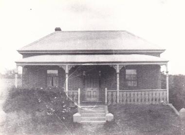
Negative - Glass Plate Negative - A early Edwardian home, 1890-1910
... Showing an early Edwardian home - steeply sloped, wide eaves, front facing gable ends, square edged weatherboards, return L-shaped verandah, corrugated iron roofing. Also has iron lacework....Showing an early Edwardian home - steeply sloped, wide eaves, front facing gable ends, square edged weatherboards, return L-shaped verandah, corrugated iron roofing. Also has iron lacework. Negative Glass Plate Negative - A early Edwardian home ...Glass plate negative. Showing an early Edwardian home - steeply sloped, wide eaves, front facing gable ends, square edged weatherboards, return L-shaped verandah, corrugated iron roofing. Also has iron lacework. -
 Federation University Historical Collection
Book, Iron Roofs: examples of design, 1884 (exact)
... ...roofing...iron...Barker Library (top floor) Mount Helen goldfields civil engineering design roofing iron and steel Book. Large brown hard cover. ...Book. Large brown hard cover. Title written in gold on front cover and on spine. Manufacturer name also written in gold on spine. Illustrations, plates (black & white). 37 p. + plates.civil engineering, design, roofing, iron and steel -
 Phillip Island and District Historical Society Inc.
Photograph, 1978/9
... A large weatherboard construction with bay windows and corrugated iron roofing....A large weatherboard construction with bay windows and corrugated iron roofing. local history photographs buildings - historical rural industry coloured photograph john cook churchill island Coloured photograph showing the homestead on Churchill Island. ...The Homestead was probably built about 1872 when Samuel Amess became the owner of Churchill Island. A large weatherboard construction with bay windows and corrugated iron roofing.Coloured photograph showing the homestead on Churchill Island. Bay windowed rooms projecting forward on either side of the verandah. Not the sundial in the foreground.local history, photographs, buildings - historical, rural industry, coloured photograph, john cook, churchill island -
 Kilmore Historical Society
Photograph, 67 and 69 Sydney Street
... The forge is housed in a scrappy looking building with mis-matching corrugated iron roofing and rendered walls. ...The forge is housed in a scrappy looking building with mis-matching corrugated iron roofing and rendered walls. 67 and 69 Sydney Street Photograph Photograph ...18cm x 12.5cm black and white photograph of the buildings at 67 and 69 Sydney Street. Pictured is Cuts 'n' Curls, Ye Olde Blacksmith Shoppe and a Milk Bar. The forge is housed in a scrappy looking building with mis-matching corrugated iron roofing and rendered walls. storefronts, shopfronts, retail stores, hair salons, hair dressers, forges, milk bars, blacksmiths -
 Phillip Island and District Historical Society Inc.
Photograph, Anderson Family Homestead
... Single fronted Brick Cottage, corrugated iron roofing. One Chimney on left. Two front windows. ...Phillip Island and District Historical Society Inc. phillip-island-and-the-bass-coast Not known local history photography photographs slides film buildings historic cottage black & white photograph mrs emma anderson jacobs Single fronted Brick Cottage, corrugated iron roofing. One Chimney on left. Two front windows. ...Not knownSingle fronted Brick Cottage, corrugated iron roofing. One Chimney on left. Two front windows. Wooden front door. Wrought iron balustrade and on top of posts attached to Porch. Five steps up to Verandah and direct to front door. Anderson's bricks used for the house.local history, photography, photographs, slides, film, buildings, historic, cottage, black & white photograph, mrs emma anderson jacobs -
 Kew Historical Society Inc
Photograph - 'Reno', 10 St John's Parade, John T Collins, 1977
... Architectural elements revealed in this photo by John T Collins include: four-sided construction; trellis and weatherboard walls; corrugated iron roofing. Re-use as woodshed. General dilapidated condition. ...Architectural elements revealed in this photo by John T Collins include: four-sided construction; trellis and weatherboard walls; corrugated iron roofing. Re-use as woodshed. General dilapidated condition. ...‘Reno’, stood on the east side of St John’s Parade. Its earliest recorded owner was the architect Samuel Cocking who lived there from c.1865 until his death in 1888. The original landholding was bordered by Cotham Road, Glenferrie Road, Wellington Street, and Charles Street. The southern portion of this land included a fine orchard, with many imported trees. The old summer house, at first in the orchard, was later removed to the house garden. The MMBW Detail Plan No.1576 (1904) shows the remaining portion of the original land holding, including a semi-circular pathway at the front, and garden features such as an aviary, a fountain and grotto, and a fernery. The garden including rare plants supplied by Baron Von Mueller, surrounds the cottage in a tangled frenzy. Despite a ‘local significance’ classification by the National Trust, the house was demolished in 1977.Side of the original, relocated summer house of 'Reno' at 10 St John's Parade, Kew, (demolished 1977). Architectural elements revealed in this photo by John T Collins include: four-sided construction; trellis and weatherboard walls; corrugated iron roofing. Re-use as woodshed. General dilapidated condition. "Kew 'Reno' 10 St Johns Pde / John Collins, 11 Anderson Road, Hawthorn East, 3123, Film 35B Exposure 24"reno - st john's parade -- kew (vic.), john t collins -
 Phillip Island and District Historical Society Inc.
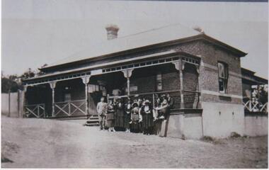
Photograph, Cowes Post Office, Phillip Island, 1920
... Brick above concrete building with two brick chimneys. Iron roofing, fenced verandah. Group of 12 people, males suited, with collars and ties, ladies all in long skirts, jackets and hats....Brick above concrete building with two brick chimneys. Iron roofing, fenced verandah. Group of 12 people, males suited, with collars and ties, ladies all in long skirts, jackets and hats. local history photographs post office cowes black & white photograph ann brown collection Bruce Bennett P.O.Cowes (written on back of photograph) Post Office with group of people standing and seated in front of building Cowes Post Office, Phillip Island Photograph Photograph ...Post Office on corner of Thompson Avenue and The Esplanade. Brick above concrete building with two brick chimneys. Iron roofing, fenced verandah. Group of 12 people, males suited, with collars and ties, ladies all in long skirts, jackets and hats.Post Office with group of people standing and seated in front of buildingP.O.Cowes (written on back of photograph)local history, photographs, post office, cowes, black & white photograph, ann brown collection, bruce bennett -
 Phillip Island and District Historical Society Inc.
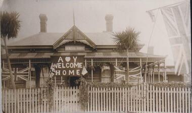
Photograph, Genesta Guesthouse, Cowes, Phillip Island
... The building of wood and corrugated iron roofing. Features turret front, two brick chimneys and sporting a Union Jack on flagpole, and Union Jacks draping across the verandah. ...The building of wood and corrugated iron roofing. Features turret front, two brick chimneys and sporting a Union Jack on flagpole, and Union Jacks draping across the verandah. ...Stanley Kennon originally owned Genesta House. It was sold to the Perry sisters, to Mr & Mrs Odlund, to Mrs Toovey Snr. and then to Mr H Billson who owned the guesthouse in 1935 - 36 when it burned to the ground.Front view close up of Genesta Guesthouse. The building of wood and corrugated iron roofing. Features turret front, two brick chimneys and sporting a Union Jack on flagpole, and Union Jacks draping across the verandah. The sign covering the front door says "Welcome Home". Two palm trees and a hedge are behind a picket fence and gate.local history, photographs, genesta guesthouse, cowes, phillip island, sepia photograph, guesthouses, bruce bennett, betty kuc collection -
 Kew Historical Society Inc
Photograph - 'Reno', 10 St John's Parade, John T Collins, 1977
... Architectural elements revealed in this photo by John T Collins include: hip roof construction; corrugated iron roofing [over shingles]; unvarnished/unpainted external weatherboards; Externally opening 1860s-style casement window. ...Architectural elements revealed in this photo by John T Collins include: hip roof construction; corrugated iron roofing [over shingles]; unvarnished/unpainted external weatherboards; Externally opening 1860s-style casement window. ...‘Reno’, stood on the east side of St John’s Parade. Its earliest recorded owner was the architect Samuel Cocking who lived there from c.1865 until his death in 1888. The original landholding was bordered by Cotham Road, Glenferrie Road, Wellington Street, and Charles Street. The southern portion of this land included a fine orchard, with many imported trees. The old summer house, at first in the orchard, was later removed to the house garden. The MMBW Detail Plan No.1576 (1904) shows the remaining portion of the original land holding, including a semi-circular pathway at the front, and garden features such as an aviary, a fountain and grotto, and a fernery. The garden including rare plants supplied by Baron Von Mueller, surrounds the cottage in a tangled frenzy. Despite a ‘local significance’ classification by the National Trust, the house was demolished in 1977.Partial view, side of the weatherboard cottage in St John's Parade, Kew, known as 'Reno' (demolished 1977). Architectural elements revealed in this photo by John T Collins include: hip roof construction; corrugated iron roofing [over shingles]; unvarnished/unpainted external weatherboards; Externally opening 1860s-style casement window. General dilapidated condition. "Kew 'Reno' 10 St Johns Pde / John Collins, 11 Anderson Road, Hawthorn East, 3123, Film 35B Exposure 26"reno - st john's parade -- kew (vic.), john t collins -
 Kew Historical Society Inc
Photograph - 'Reno', 10 St John's Parade, John T Collins, 1977
... Architectural elements revealed in this photo by John T Collins include: two wing, hip roof construction; external buildings at angles to main wing; corrugated iron roofing [over shingles]; brick chimney external to building; unvarnished/unpainted external weatherboards. ...Architectural elements revealed in this photo by John T Collins include: two wing, hip roof construction; external buildings at angles to main wing; corrugated iron roofing [over shingles]; brick chimney external to building; unvarnished/unpainted external weatherboards. ...‘Reno’, stood on the east side of St John’s Parade. Its earliest recorded owner was the architect Samuel Cocking who lived there from c.1865 until his death in 1888. The original landholding was bordered by Cotham Road, Glenferrie Road, Wellington Street, and Charles Street. The southern portion of this land included a fine orchard, with many imported trees. The old summer house, at first in the orchard, was later removed to the house garden. The MMBW Detail Plan No.1576 (1904) shows the remaining portion of the original land holding, including a semi-circular pathway at the front, and garden features such as an aviary, a fountain and grotto, and a fernery. The garden including rare plants supplied by Baron Von Mueller, surrounds the cottage in a tangled frenzy. Despite a ‘local significance’ classification by the National Trust, the house was demolished in 1977.Partial view, north side of the weatherboard cottage in St John's Parade, Kew, known as 'Reno' (demolished 1977). Architectural elements revealed in this photo by John T Collins include: two wing, hip roof construction; external buildings at angles to main wing; corrugated iron roofing [over shingles]; brick chimney external to building; unvarnished/unpainted external weatherboards. General dilapidated condition. "Kew 'Reno' 10 St Johns Pde / John Collins, 11 Anderson Road, Hawthorn East, 3123, Film 35B Exposure 27"reno - st john's parade -- kew (vic.), john t collins -
 Sunbury Family History and Heritage Society Inc.
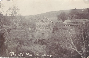
Photograph, The Old Mill Sunbury
... At that time the 20 ton metal wheel and the iron roofing removed to aid the war effort....At that time the 20 ton metal wheel and the iron roofing removed to aid the war effort. This mill is one of a number that were built along the water courses in the Sunbury-Bulla area to process the wheat grown in the area. ...Scottish miller and immigrant, John Eadie established his water-driven flour mill on Jacksons Creek in Sunbury in 1861.To make of a sufficient water supply to operate the mill, he built a weir and a water-race to drive it. Some of these can be seen today. The machinery for the mill was bought from Scotland and transported here. The mill continued to operate until 1914. At that time the 20 ton metal wheel and the iron roofing removed to aid the war effort.This mill is one of a number that were built along the water courses in the Sunbury-Bulla area to process the wheat grown in the area.A non-digital black and white photograph in post card format of a an old bluestone mill building sited on the bank of a watercourse in a deep valley with bare hills in the background. The remains of the water wheel are at the rear of the building. A New Year greeting dated 24th Dec. 1907 has been written on the back from H.H in Bulla to his aunt, Miss M.A.Ripon who was staying with Mrs. Tricks in Canterbury at the time.The Old Mill Sunburyjohn eadie, the old mill, milling, jacksons creek -
 Sunbury Family History and Heritage Society Inc.
Photograph, The Old Mill Sunbury
... The mill continued operating until the outbreak of World War 1 when the metal wheel and iron roofing were taken and used for the war effort. ...The mill continued operating until the outbreak of World War 1 when the metal wheel and iron roofing were taken and used for the war effort. ...The former mill and weir shown in the photograph were sited on the banks of Jacksons Creek downstream from the town of Sunbury. John Eadie, a Scottish immigrant established the water-driven flour mill on the banks of the creek after he arrived in the colony in 1866. The mill continued operating until the outbreak of World War 1 when the metal wheel and iron roofing were taken and used for the war effort. The hill in the back ground with the trees and buildings was the site of the former Sunbury Asylum. Milling was one of Sunbury's early industries that were established in the district.A non-digital black and white photograph of a building and a lake in a valley. Buildings and trees are visible on a distant hillside.OLD MILL SUNBURYsunbury flour mill., milling -
 Sunbury Family History and Heritage Society Inc.
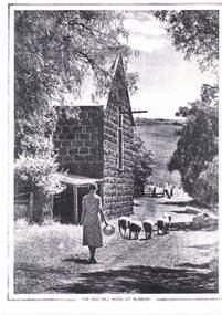
Photograph, The Old Mill Road at Sunbury
... In 1914 the large shell and the iron roofing were removed to aid the war effort. ...In 1914 the large shell and the iron roofing were removed to aid the war effort. ...John Eadie, a miller from Perthshire in Scotland, established a water-driven flour mill on the banks of the Jacksons Creek downstream from the Macedon Street crossing in 1861. He also built a weir and water-race to ensure there was plenty of water to drive the mill. The mill produced flour until the early years of the twentieth century. In 1914 the large shell and the iron roofing were removed to aid the war effort. The weir can still be seen but the ruins of the mill are the only evidence of its early existence.Milling was one of Sunbury's early industries in the early days of European settlement. A copy of an old non-digital black and white photograph of a lady driving a small flock of sheep past a blue stone building, which has a pitched corrugated iron roof. The photograph has a border on three of its sides with the caption below the image. john eadie, sunbury flour mill., flour production -
 Phillip Island and District Historical Society Inc.
Photograph, 1978/79
... Timber building with corrugated roofing. Old iron water tank in front of building....Timber building with corrugated roofing. Old iron water tank in front of building. ...January 1869 at the first land sale in Cowes, John West bought Lot 1 for £45 . In the 1870's he built the first Chicory Kiln on Phillip Island. With his brother, Solomon, he started the General Store next to the Chicory Kiln in Thompson Avenue. Over the years the original building was extended and altered.Photograph of remains of West's store, Cowes. Timber building with corrugated roofing. Old iron water tank in front of building.local history, photographs, buildings, historic, buildings - historical, sepia photograph, john cook, phillip island, west's general store -
 Phillip Island and District Historical Society Inc.
Photograph, Innishowen, 1978/9
... Coloured photograph of painting of Innishowen showing house and garden. Green roofing iron....Coloured photograph of painting of Innishowen showing house and garden. Green roofing iron. Innishowen Photograph ...Innishowen - home of William Harbison from 1868. Bought by Gliddon Family in 1911 and demolished in 1976 by owner G Gliddon. Present photograph of painting taken 1978/1979Innishowen - the home of William Harbison who owned most of the south western section of Phillip Island from 1868. Coloured photograph of painting of Innishowen showing house and garden. Green roofing iron.local history, photographs, buildings - historical, coloured photograph, john cook, innishowen, ventnor, phillip island, harbison -
 Kilmore Historical Society
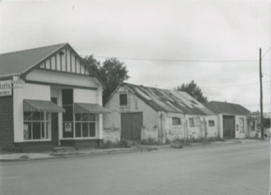
Photograph, 83 Sydney Street
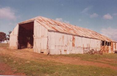
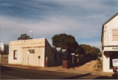
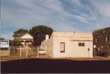
... The building is a light coloured corrugated iron building with angled roofing. ...The building is a light coloured corrugated iron building with angled roofing. 83 Sydney Street Photograph Photograph ...14cm x 9 cm black and white photograph of the building on 83 Sydney Street. The building is a light coloured corrugated iron building with angled roofing. Written on the back: 83 Syd 124 -
 Lakes Entrance Historical Society
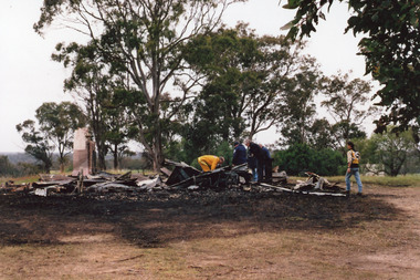
Photograph - Nungurner Hall/original Nungurner School fire 2011, 2011
... Shows heap of burnt rubble, roofing iron and base of chimney still standing. ...Shows heap of burnt rubble, roofing iron and base of chimney still standing. ...Date made September 2011Colour photograph of the remains of the Nungurner Hall, previously State School no. 4226, after destruction by fire. Shows heap of burnt rubble, roofing iron and base of chimney still standing. Fire brigade and police in attendance. Nungurner Victoriaschools, disasters, fires -
 Bendigo Historical Society Inc.
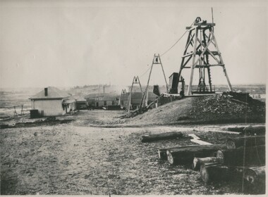
Photograph - GREAT EXTENDED HUSTLERS MINE, 1875
... Photograph shows five weatherboard clad buildings with corrugated iron roofing. Poppet legs and cable support trestles. ...Photograph shows five weatherboard clad buildings with corrugated iron roofing. Poppet legs and cable support trestles. ...black and white photograph of the Great Extended Hustlers Quartz Mining claim. Photograph shows five weatherboard clad buildings with corrugated iron roofing. Poppet legs and cable support trestles. Bush logs in foregound at right. Office at left, battery house centre background. Main shaft right. Copy of original photo. On face of photo in indian ink: area of 24 acres, has 6 shafts, equals 4000 feet of sinking. No less than 13 levels and 16 x cuts making a total of 12000 feet. Amount spent in labour 228,000 ( pounds stg. ) Quartz raised 144,5000 tons and yields to date 188,000 ozs of gold. Dividends 585,000 ( pounts st.) nearly 20/-/ a share. Employment to nearly 200 men. It is stated this rich mine changed hands the early days for only 30/-/-. On back in black ink ' Gr. Extended Hustlers. Bottom right corner : A. Richardson/29 Harrison Street/Bendigo.N.J. Caireorganization, business, great extended hustlers mine -
 Phillip Island and District Historical Society Inc.
Photograph, 1978/9
... He used timber washed up by the sea and roofing iron from the dome of the Exhibition Building in London. ...He used timber washed up by the sea and roofing iron from the dome of the Exhibition Building in London. ...The big Hayshed was built by J. D. McHaffie on his property at Ventnor. He used timber washed up by the sea and roofing iron from the dome of the Exhibition Building in London. After purchasing the historic McHaffie homestead, Mr Harbison removed most of the buildings to Innishowen. It was still standing in 1977."Innishowen". Coloured photograph of large galvanised iron haystack, rusted with age. Part of timber frame visible at right hand side. Training Jinker shown against the side of shed.local history, photographs, buildings - historical, coloured photograph, john cook, innishowen, ventnor, phillip island -
 Kilmore Historical Society
Photograph, 83 Sydney Street
... The building is a light coloured building with a corrugated iron facade and angular roofing. On the right of the photograph you can see the previous position of the Goulburn Murray Credit Union....The building is a light coloured building with a corrugated iron facade and angular roofing. On the right of the photograph you can see the previous position of the Goulburn Murray Credit Union. 83 Sydney Street Photograph Photograph ...15cm x 10cm coloured photograph of the building on 83 Sydney Street. The building is a light coloured building with a corrugated iron facade and angular roofing. On the right of the photograph you can see the previous position of the Goulburn Murray Credit Union. -
 Kilmore Historical Society
Photograph, 83 Sydney Street
... The building is a light coloured corrugated iron building with angled roofing. you can see a private residence on the left of the building, the house was set back on the property and has a ute parked in the driveway. ...The building is a light coloured corrugated iron building with angled roofing. you can see a private residence on the left of the building, the house was set back on the property and has a ute parked in the driveway. 83 Sydney Street Photograph Photograph ...15cm x 10cm coloured photograph of the building on 83 Sydney Street. The building is a light coloured corrugated iron building with angled roofing. you can see a private residence on the left of the building, the house was set back on the property and has a ute parked in the driveway. -
 Eltham District Historical Society Inc
Film - Video (DVD), Frank Stokes, Stokes Family, 1950-1977
... Constructed mostly from second-hand materials, which was hard to obtain, especially iron for roofing. Frank finished work at Kennons October 31, 1945, and in March 1946 he sold the Mitcham house for £1230 plus £170 for furniture. ...Constructed mostly from second-hand materials, which was hard to obtain, especially iron for roofing. Frank finished work at Kennons October 31, 1945, and in March 1946 he sold the Mitcham house for £1230 plus £170 for furniture. ...Various family scenes taken from outside the family home on the southeast corner of the intersection of Nyora Road and Pitt Street with Eucalyptus Road. Also, scenes of the Stokes Orchard and equipment used, construction of water reservoir at the end of Nyora Road near Reynolds Road and Diosma Road as well as early stages of the Stokes Orchard housing development. Frank Stokes worked as a qualified accountant at Kennons leather factory in Burnley, while living at 1 Thomas Street, Mitcham. He suffered from migraines and wanted to go back to the land (he had previously worked on farms and orchards since coming to Australia in 1926 both in WA and Vic.). He first travelled to the district by train in July 1942 to find land with the intention to establish an orchard. By chance he met Arthur Bird of Bird Orchard (bounded by Pitt Street, Eucalyptus Road and Wattle Grove) and they got talking over their common interest. Arthur put Frank up for the night and pointed out the land, 158 acres- Taylor Estate- £900, part of Crown Allotment 15, Section 5, Parish of Nillumbik (CA15) somewhat diagonally opposite Bird Orchard. He applied through the Riverina Agency to purchase the land who in turn had to get permission from Canberra to sell as there was a new government regulation banning land sales except for immediate production. He obtained a loan on his Mitcham house of £600 @ 5% and paid £450 deposit with quarterly payments of £15 over 5 years. The title to the property was issued May 15, 1946. He was helped and advised by Arthur Bird who farmed the neighbouring orchard. Early 1943 he took possession and would catch the train out to Eltham on Fridays after work and began building a hut for shelter and to lock up tools. He was able to pay a neighbour (Hawkins) to help with clearing and fencing 25 acres and with a horse and single furrowed plow, planted approximately 2,500 fruit trees - cherries, peaches, plums, almonds, pears, apricots and lemons as well as a few apples and oranges; a massive job. A huge problem was hares and rabbits eating all the new buds off the tiny trees. As well as laying poison he painted the trees with a mixture of cow manure and lime. Often working by moonlight. It was extremely difficult to get wire and wire netting because of the war but after much effort he obtained a permit from the Agricultural Department for supplies in March 1944. In February 1945 he applied for a permit to build a “packing shed” as no house building allowed. It was to be 33 feet x 21 feet and cost £312. Constructed mostly from second-hand materials, which was hard to obtain, especially iron for roofing. Frank finished work at Kennons October 31, 1945, and in March 1946 he sold the Mitcham house for £1230 plus £170 for furniture. The family of five then moved into a very unfinished at Eltham, which was a struggle to weatherproof. Eventually rooms were divided off and lined with hessian bags and whitewashed. Their income was firewood (cut and sold), selling rockery stones and cut sweet bursaria. (It was discovered during the 1940s that Bursaria contained the sunscreen compound Aesculin. The RAAF utilised this compound from Bursaria during WW2 for pilots and gunners.) The orchard’s first fruit sale was a 1/2 case of Le Vanq peaches in December 1947 - 8 shillings. In 1956 plans for house were drawn and Glen Iris bricks purchased (1956 Olympic Rings variant). The building of the house commenced in 1957 - 12 feet of original packing shed removed – and was completed in 1959. Water was connected from newly built pressure storage on the property at the end of 1959 and the electricity connection for the first time at 3pm on April 29, 1960. In the mid-1970s the Shire of Eltham divided the orchard up into numerous rate-able parcel lots, which became unaffordable for Frank. Consequently, Stokes Orchard was turned into a housing development by Macquarie Builders and marketed as the Stokes Orchard Estate in two stages; Stage 1 encompassing Scarlet Ash Court, Ironbark Close and Peppermint Grove bounded by Nyora and Eucalyptus roads c.1976 and Stage 2 encompassing Stokes Place, Orchard Way, The Crest and The Lookout bound by Nyora and Diosma roads c.1979. The development of Orchard Way, The Crest and The Lookout did not proceed as planned due to the lack of the sewer along Diosma Road and so many of the proposed lots were incorporated into five-acre parcels instead. With the arrival of the sewer along Diosma Road many years later, most of these five-acre parcels have since been subdivided many times.Representative of the orchard growing areas of ElthamMP4 00:24:39; 426MB Digital file only - Digitised by EDHS from a DVD copy on loan from Beryl Bradbury (nee Stokes), daughter of Frank Stokes. 24 min duration compilation of home movie Super 8mm film shot by Frank Stokes brother-in-law.beryl bradbury (nee stokes) collection, frank stokes, nyora road, stokes orchard, stokes orchard estate, stokes place, video recording -
 Eltham District Historical Society Inc
Photograph - Aerial Photograph, Landata, Eltham; Crown Allotment 15, Section 5, Parish of Nillumbik (Stokes Orchard Estate), Dec. 1945
... It was constructed mostly from second-hand materials, which were hard to obtain, especially iron for roofing. Stokes finished work at Kennons on October 31, 1945, and in March 1946 he sold the family home at Mitcham for £1,230 plus £170 for furniture. ...It was constructed mostly from second-hand materials, which were hard to obtain, especially iron for roofing. Stokes finished work at Kennons on October 31, 1945, and in March 1946 he sold the family home at Mitcham for £1,230 plus £170 for furniture. ...Centred on present day Diosma Rd, Stokes Pl, Nyora Rd and Eucalyptus Rd Historic Aerial Imagery Source: Landata.vic.gov.au Aerial Photo Details: Project No :5 Project : MELBOURNE AND METROPOLITAN AREA PROJECT Run : 36 Frame : 60546 Date : 12/1945 Film Type : B/W Camera : EAG4 Flying Height : 10200 Scale : 6000 Film Number : 195 GDA2020 : 37°42'47"S, 145°09'56"E MGA2020 : 338306, 5824438 (55) Melways : 22 C4 (ed. 42) A History of the Development of Crown Allotment 15, Section 5, Parish of Nillumbik – Stokes Orchard Crown Allotment 15, Section 5, Parish of Nillumbik (CA15) is a square allotment of 158 acres or approximately a quarter of a square mile. It lies just beyond the eastern end of Pitt Street, south of Nyora Road to the northern end of Eucalyptus Road and extends east from Eucalyptus Road to Reynolds Road. The topography of CA15 is generally steep, sloping up to a hill near the centre of the land, the ridgeline passing through the properties along the southern side of Diosma Road. Eucalyptus Road is a straight north-south road with its northern end at the north west corner of CA15. Until the end of the 1970s this road was an un-named Government Road and was largely not open to traffic. With residential development in the 1970s the road was constructed, and the council allocated the name obviously in recognition of the predominant species of the local bushland. CA15 was purchased from the Crown by George D’Arley Boursiquot, a prominent Melbourne printer, on 28th October 1852. On November 23, 1922, former Member for Gippsland and Melbourne Real Estate Agent, Hubert Patrick Keogh purchased the allotment then sold it March 13, 1925, to local farmer, Robert David Taylor, a former Shire of Eltham Councillor (1911-1920) and Shire President (1919). Taylor had extensive land holdings stretching west towards Bible Street and Main Road. The Taylor home was situated at the top of the hill in Bible Street at present day 82 Bible Street. At the time of Taylor’s purchase in 1925, CA15 was subdivided into 48 lots that could be described as small rural properties or large residential lots. A typical lot size was one hectare or 2.5 acres. The subdivision created two roads, Nyora Road, and Diosma Road, each following an irregular alignment between Eucalyptus and Reynolds Roads. However, the lots were not sold off separately nor were the roads constructed. The land effectively remained as one parcel for many further years. Robert David Taylor died November 30, 1934, and probate was granted to his son of the same name, Robert David Taylor of Bible Street, Salesman and William McLelland Vance Taylor of 73 Emmeline Street, Northcote, Clerk, with the transfer of the land into their names on July 8, 1935. Frank Stokes worked as a qualified accountant at Kennons leather factory in Burnley, while living at 1 Thomas Street, Mitcham. He suffered from migraines and wanted to return to working the land (he had previously worked on farms and orchards since coming to Australia from England in 1926, both in WA and Vic.). He first travelled to the district by train in July 1942 to find land with the intention to establish an orchard. By chance he met Arthur Bird of Bird Orchard (bounded by Pitt Street, Eucalyptus Road, and Wattle Grove) and they got talking over their common interest. Arthur put Frank up for the night and pointed out the land, 158 acres- part of the Taylor Estate- £900, Crown Allotment 15, Section 5, Parish of Nillumbik (CA15) somewhat diagonally opposite Bird Orchard. Stokes applied through the Riverina Agency to purchase the land who in turn applied for permission from Canberra to sell as there was a new government regulation introduced during the Second World War banning land sales except for immediate production. Stokes obtained a loan on his Mitcham house of £600 @ 5% and paid £450 deposit with quarterly payments of £15 spread over 5 years. Stokes was assisted and advised by Arthur Bird who farmed the neighbouring orchard. In early 1943 Stokes took possession and would catch the train out to Eltham on Fridays after work and began building a hut on the corner of Nyora Road and the Government Road (Eucalyptus Road) for shelter and to lock up tools. He established an orchard on the central western part of the land through the centre of which ran a natural waterway (part of the present-day linear park) and was able to pay a neighbour (Hawkins) to help with clearing and fencing 25 acres, and with a horse and single furrowed plough, planted approximately 2,500 fruit trees - cherries, peaches, plums, almonds, pears, apricots and lemons as well as a few apples and oranges; a massive task. Aerial photographs from the 1940s through to the 1990s clearly show the orchard with most of the larger CA15 site remaining as natural bushland. A huge problem was hares and rabbits eating all the new buds off the tiny trees. As well as laying poison he painted the trees with a mixture of cow manure and lime, often working by moonlight. Procurement of wire and wire netting was difficult because of the war but after much effort he obtained a permit from the Agricultural Department for supplies in March 1944. In February 1945 Stokes applied for a permit to build a “packing shed” as no house building was allowed. It was to be 33 feet x 21 feet and cost £312. It was constructed mostly from second-hand materials, which were hard to obtain, especially iron for roofing. Stokes finished work at Kennons on October 31, 1945, and in March 1946 he sold the family home at Mitcham for £1,230 plus £170 for furniture. On May 15, 1946, title to the CA15 property was issued to Frank Howard Alfred Stokes, Orchardist and Gladys Ethel Stokes, Married Woman, both of Pitt Street, Eltham. The family of five then moved into the very unfinished “packing shed” at Eltham, which was a struggle to weatherproof. Eventually rooms were divided off and lined with hessian bags and whitewashed. Their income was firewood (cut and sold), selling rockery stones and cut Sweet Bursaria. (It was discovered during the 1940s that Sweet Bursaria contained the sunscreen compound Aesculin. The RAAF utilised this compound from Sweet Bursaria during WW2 for pilots and gunners.) The orchard’s first fruit sale was a half-case of Le Vanq peaches in December 1947 for the price of 8 shillings. In 1956 plans for house were drawn and Glen Iris bricks purchased (1956 Olympic Rings variant). The building of the house commenced in 1957 - 12 feet of original packing shed was removed – and was completed in 1959. Water was connected from newly built pressure storage on the property at the end of 1959 and the electricity connection for the first time at 3pm on April 29, 1960. The house remains to present day (somewhat modified) at 1 Nyora Road, home to Nyora Studio Gallery. On occasions, spare remnants of the 1956 bricks have been known to be unearthed in gardens on the estate as they were utilised by Frank Stokes to fill in rabbit holes. On May 26, 1950, a parcel of land was compulsorily acquired by the Melbourne and Metropolitan Board of Works on the hilltop to establish an easement for a high-level service reservoir to augment Eltham’s water supply. The project also included pipe tracks for the necessary water mains. The reservoir has now been superseded by higher level water tanks east of Reynolds Road and its former site is now a public reserve. On November 27, 1964, the State Electricity Commission served notice to compulsorily acquire a further parcel through the eastern part of the land for a major electricity transmission line that augmented supply from the La Trobe Valley to Melbourne. The easement was registered February 11, 1966. The easement was widened July 18, 1969 for a second transmission line to be constructed. In 1971 Melbourne Metropolitan Planning Scheme amendments adopted Nyora Road as the boundary between a residential zone to the north and a rural zone to the south. This determined the future development of the land. In the mid-1970s the Shire of Eltham divided the orchard into numerous rate-able parcel lots, the 48 lots having been established in 1925 and the subsequent rates assessment proved unsustainable for Stokes. He commenced selling lots outside the boundary of the orchard, north of Diosma and South of Nyora. However shortly later the land between Nyora and Diosma Roads and west of the electricity easement was sold and subdivided into residential lots, a housing development by Macquarie Builders and marketed as the Stokes Orchard Estate. New streets were created, and most were named after trees, although one, Stokes Place, commemorates the former owners. The development was undertaken in two stages; Stage 1 (1975) encompassing Scarlet Ash Court, Ironbark Close and Peppermint Grove bounded by Nyora and Eucalyptus roads and Stage 2 (1978) encompassing Stokes Place, Orchard Way, The Crest and The Lookout bound by Nyora and Diosma roads. The developer, Macquarie Builders went bankrupt shortly after the release of Stage 2 leaving many purchasers to fend for themselves and arrange for their own independent builders. There were also difficulties with sewerage for the land immediately south of Diosma Road and so the conventional residential lots were abandoned in favour of larger lots. The development of Orchard Way, The Crest and The Lookout did not proceed as planned and the proposed lots were incorporated into five-acre parcels instead. These included a low-density group housing development by the Graves family and the award winning Choong House (1983) with Gordon Ford developed garden immediately next door situated on the ridge of the hill nestled amongst the original bush, Eucalypt trees and Sweet Bursaria. In 1994, Nillumbik Shire Council applied Significant Environment and Significant Landscape overlays upon the properties on the south side of Diosma Road to ensure protection of this natural bush garden environment. With the arrival of the sewer along Diosma Road in the 1990s, most of these five-acre parcels have since been subdivided multiple times. The Choong house presently sits on a 2.7-acre property, which in 2022 Nillumbik Council nominated for Cultural Significance Heritage protection and is considered potentially significant at State level. The Stokes family were also associated with the Eltham Christian Church. In the 1970s this church had met in temporary premises in Eltham. Lots of the original 1925 subdivision remained south of Nyora Road and a number of these lots were utilized for the Eltham Christian School, which was established by the Eltham Christian Church in 1981. The school operated on this site until 2000. The premises are now used by The Vine Baptist Church. By the mid-1980s the whole of CA15 had been developed for residential and school purposes, except for the sections north of Diosma Road and between the transmission lines and Reynolds Road. Sewerage issues had been resolved for the section north of Diosma Road and in 1987 it was in the process of being subdivided into residential lots. The development coincided with the discovery of colonies of the rare and endangered Eltham Copper Butterfly on the site. This resulted in a community and political campaign to save the butterfly habitat. With the co-operation of the land developer the subdivision was altered to create two bushland reserves in the critical butterfly habitat areas. In the late 1980s the State Government was investigating options for establishing a metropolitan ring road link between Diamond Creek and Ringwood. The chosen route was adjacent to Reynolds Road and so this created a freeze on development of CA15 between Reynolds Road and the electricity easement. The ring road proposal was eventually abandoned, and this part of the land was subdivided into low density residential lots. Diosma Road has been discontinued at the electricity easement and the eastern part incorporated into View Mount Court with access from Reynolds Road. The whole of CA15 has now been developed for residential or associated purposes, ranging from conventional density to quite low density south of Nyora Road. Some remnants of the orchard remain, a few cherry trees on the Graves property and a lone apple tree in Stokes Place. The butterfly reserves comprise significant areas of remnant bushland. Linear reserves through the estate link with central Eltham via the Woodridge linear reserve and with Research along the electricity easement. CA15 as it exists today has a complicated history of rural use, Government acquisition, urban development, and community action. References: • “Stokes Orchard, an incomplete history”; Russell Yeoman with Doug Orford • Correspondence, Beryl Bradbury (nee Stokes) • Aerial Photographs, 1931-1991, Landata (landata.vic.gov.au) • Certificate of Title, Vol. 4930 Fol. 985900 • Plan Number LP 10859 aerial photo, diosma road, eltham copper butterfly, eucalyptus road, ironbark close, nyora road, peppermint grove, peter & elizabeth pidgeon collection, power transmission lines, reynolds road, scarlet ash court, stokes orchard estate, stokes place, woodridge estate, frank stokes -
 Eltham District Historical Society Inc
Photograph - Aerial Photograph, Landata, Eltham; Crown Allotment 15, Section 5, Parish of Nillumbik (Stokes Orchard Estate), Nov. 1931
... It was constructed mostly from second-hand materials, which were hard to obtain, especially iron for roofing. Stokes finished work at Kennons on October 31, 1945, and in March 1946 he sold the family home at Mitcham for £1,230 plus £170 for furniture. ...It was constructed mostly from second-hand materials, which were hard to obtain, especially iron for roofing. Stokes finished work at Kennons on October 31, 1945, and in March 1946 he sold the family home at Mitcham for £1,230 plus £170 for furniture. ...Centred over present day Reynolds Road and Mount Pleasant Road, Eltham (including Diosma Rd, Stokes Pl, Nyora Rd and Eucalyptus Rd) Historic Aerial Imagery Source: Landata.vic.gov.au Aerial Photo Details: Project No :1931 Project : MALDON PRISON Run : 21 Frame : 3160 Date : 11/1931 Film Type : B/W Camera : F8 Flying Height : 11000 Scale : 18860 Film Number : 60 GDA2020 : 37°43'31"S, 145°10'20"E MGA2020 : 338912, 5823086 (55) Melways : 22 E8 (ed. 42) A History of the Development of Crown Allotment 15, Section 5, Parish of Nillumbik – Stokes Orchard Crown Allotment 15, Section 5, Parish of Nillumbik (CA15) is a square allotment of 158 acres or approximately a quarter of a square mile. It lies just beyond the eastern end of Pitt Street, south of Nyora Road to the northern end of Eucalyptus Road and extends east from Eucalyptus Road to Reynolds Road. The topography of CA15 is generally steep, sloping up to a hill near the centre of the land, the ridgeline passing through the properties along the southern side of Diosma Road. Eucalyptus Road is a straight north-south road with its northern end at the north west corner of CA15. Until the end of the 1970s this road was an un-named Government Road and was largely not open to traffic. With residential development in the 1970s the road was constructed, and the council allocated the name obviously in recognition of the predominant species of the local bushland. CA15 was purchased from the Crown by George D’Arley Boursiquot, a prominent Melbourne printer, on 28th October 1852. On November 23, 1922, former Member for Gippsland and Melbourne Real Estate Agent, Hubert Patrick Keogh purchased the allotment then sold it March 13, 1925, to local farmer, Robert David Taylor, a former Shire of Eltham Councillor (1911-1920) and Shire President (1919). Taylor had extensive land holdings stretching west towards Bible Street and Main Road. The Taylor home was situated at the top of the hill in Bible Street at present day 82 Bible Street. At the time of Taylor’s purchase in 1925, CA15 was subdivided into 48 lots that could be described as small rural properties or large residential lots. A typical lot size was one hectare or 2.5 acres. The subdivision created two roads, Nyora Road, and Diosma Road, each following an irregular alignment between Eucalyptus and Reynolds Roads. However, the lots were not sold off separately nor were the roads constructed. The land effectively remained as one parcel for many further years. Robert David Taylor died November 30, 1934, and probate was granted to his son of the same name, Robert David Taylor of Bible Street, Salesman and William McLelland Vance Taylor of 73 Emmeline Street, Northcote, Clerk, with the transfer of the land into their names on July 8, 1935. Frank Stokes worked as a qualified accountant at Kennons leather factory in Burnley, while living at 1 Thomas Street, Mitcham. He suffered from migraines and wanted to return to working the land (he had previously worked on farms and orchards since coming to Australia from England in 1926, both in WA and Vic.). He first travelled to the district by train in July 1942 to find land with the intention to establish an orchard. By chance he met Arthur Bird of Bird Orchard (bounded by Pitt Street, Eucalyptus Road, and Wattle Grove) and they got talking over their common interest. Arthur put Frank up for the night and pointed out the land, 158 acres- part of the Taylor Estate- £900, Crown Allotment 15, Section 5, Parish of Nillumbik (CA15) somewhat diagonally opposite Bird Orchard. Stokes applied through the Riverina Agency to purchase the land who in turn applied for permission from Canberra to sell as there was a new government regulation introduced during the Second World War banning land sales except for immediate production. Stokes obtained a loan on his Mitcham house of £600 @ 5% and paid £450 deposit with quarterly payments of £15 spread over 5 years. Stokes was assisted and advised by Arthur Bird who farmed the neighbouring orchard. In early 1943 Stokes took possession and would catch the train out to Eltham on Fridays after work and began building a hut on the corner of Nyora Road and the Government Road (Eucalyptus Road) for shelter and to lock up tools. He established an orchard on the central western part of the land through the centre of which ran a natural waterway (part of the present-day linear park) and was able to pay a neighbour (Hawkins) to help with clearing and fencing 25 acres, and with a horse and single furrowed plough, planted approximately 2,500 fruit trees - cherries, peaches, plums, almonds, pears, apricots and lemons as well as a few apples and oranges; a massive task. Aerial photographs from the 1940s through to the 1990s clearly show the orchard with most of the larger CA15 site remaining as natural bushland. A huge problem was hares and rabbits eating all the new buds off the tiny trees. As well as laying poison he painted the trees with a mixture of cow manure and lime, often working by moonlight. Procurement of wire and wire netting was difficult because of the war but after much effort he obtained a permit from the Agricultural Department for supplies in March 1944. In February 1945 Stokes applied for a permit to build a “packing shed” as no house building was allowed. It was to be 33 feet x 21 feet and cost £312. It was constructed mostly from second-hand materials, which were hard to obtain, especially iron for roofing. Stokes finished work at Kennons on October 31, 1945, and in March 1946 he sold the family home at Mitcham for £1,230 plus £170 for furniture. On May 15, 1946, title to the CA15 property was issued to Frank Howard Alfred Stokes, Orchardist and Gladys Ethel Stokes, Married Woman, both of Pitt Street, Eltham. The family of five then moved into the very unfinished “packing shed” at Eltham, which was a struggle to weatherproof. Eventually rooms were divided off and lined with hessian bags and whitewashed. Their income was firewood (cut and sold), selling rockery stones and cut Sweet Bursaria. (It was discovered during the 1940s that Sweet Bursaria contained the sunscreen compound Aesculin. The RAAF utilised this compound from Sweet Bursaria during WW2 for pilots and gunners.) The orchard’s first fruit sale was a half-case of Le Vanq peaches in December 1947 for the price of 8 shillings. In 1956 plans for house were drawn and Glen Iris bricks purchased (1956 Olympic Rings variant). The building of the house commenced in 1957 - 12 feet of original packing shed was removed – and was completed in 1959. Water was connected from newly built pressure storage on the property at the end of 1959 and the electricity connection for the first time at 3pm on April 29, 1960. The house remains to present day (somewhat modified) at 1 Nyora Road, home to Nyora Studio Gallery. On occasions, spare remnants of the 1956 bricks have been known to be unearthed in gardens on the estate as they were utilised by Frank Stokes to fill in rabbit holes. On May 26, 1950, a parcel of land was compulsorily acquired by the Melbourne and Metropolitan Board of Works on the hilltop to establish an easement for a high-level service reservoir to augment Eltham’s water supply. The project also included pipe tracks for the necessary water mains. The reservoir has now been superseded by higher level water tanks east of Reynolds Road and its former site is now a public reserve. On November 27, 1964, the State Electricity Commission served notice to compulsorily acquire a further parcel through the eastern part of the land for a major electricity transmission line that augmented supply from the La Trobe Valley to Melbourne. The easement was registered February 11, 1966. The easement was widened July 18, 1969 for a second transmission line to be constructed. In 1971 Melbourne Metropolitan Planning Scheme amendments adopted Nyora Road as the boundary between a residential zone to the north and a rural zone to the south. This determined the future development of the land. In the mid-1970s the Shire of Eltham divided the orchard into numerous rate-able parcel lots, the 48 lots having been established in 1925 and the subsequent rates assessment proved unsustainable for Stokes. He commenced selling lots outside the boundary of the orchard, north of Diosma and South of Nyora. However shortly later the land between Nyora and Diosma Roads and west of the electricity easement was sold and subdivided into residential lots, a housing development by Macquarie Builders and marketed as the Stokes Orchard Estate. New streets were created, and most were named after trees, although one, Stokes Place, commemorates the former owners. The development was undertaken in two stages; Stage 1 (1975) encompassing Scarlet Ash Court, Ironbark Close and Peppermint Grove bounded by Nyora and Eucalyptus roads and Stage 2 (1978) encompassing Stokes Place, Orchard Way, The Crest and The Lookout bound by Nyora and Diosma roads. The developer, Macquarie Builders went bankrupt shortly after the release of Stage 2 leaving many purchasers to fend for themselves and arrange for their own independent builders. There were also difficulties with sewerage for the land immediately south of Diosma Road and so the conventional residential lots were abandoned in favour of larger lots. The development of Orchard Way, The Crest and The Lookout did not proceed as planned and the proposed lots were incorporated into five-acre parcels instead. These included a low-density group housing development by the Graves family and the award winning Choong House (1983) with Gordon Ford developed garden immediately next door situated on the ridge of the hill nestled amongst the original bush, Eucalypt trees and Sweet Bursaria. In 1994, Nillumbik Shire Council applied Significant Environment and Significant Landscape overlays upon the properties on the south side of Diosma Road to ensure protection of this natural bush garden environment. With the arrival of the sewer along Diosma Road in the 1990s, most of these five-acre parcels have since been subdivided multiple times. The Choong house presently sits on a 2.7-acre property, which in 2022 Nillumbik Council nominated for Cultural Significance Heritage protection and is considered potentially significant at State level. The Stokes family were also associated with the Eltham Christian Church. In the 1970s this church had met in temporary premises in Eltham. Lots of the original 1925 subdivision remained south of Nyora Road and a number of these lots were utilized for the Eltham Christian School, which was established by the Eltham Christian Church in 1981. The school operated on this site until 2000. The premises are now used by The Vine Baptist Church. By the mid-1980s the whole of CA15 had been developed for residential and school purposes, except for the sections north of Diosma Road and between the transmission lines and Reynolds Road. Sewerage issues had been resolved for the section north of Diosma Road and in 1987 it was in the process of being subdivided into residential lots. The development coincided with the discovery of colonies of the rare and endangered Eltham Copper Butterfly on the site. This resulted in a community and political campaign to save the butterfly habitat. With the co-operation of the land developer the subdivision was altered to create two bushland reserves in the critical butterfly habitat areas. In the late 1980s the State Government was investigating options for establishing a metropolitan ring road link between Diamond Creek and Ringwood. The chosen route was adjacent to Reynolds Road and so this created a freeze on development of CA15 between Reynolds Road and the electricity easement. The ring road proposal was eventually abandoned, and this part of the land was subdivided into low density residential lots. Diosma Road has been discontinued at the electricity easement and the eastern part incorporated into View Mount Court with access from Reynolds Road. The whole of CA15 has now been developed for residential or associated purposes, ranging from conventional density to quite low density south of Nyora Road. Some remnants of the orchard remain, a few cherry trees on the Graves property and a lone apple tree in Stokes Place. The butterfly reserves comprise significant areas of remnant bushland. Linear reserves through the estate link with central Eltham via the Woodridge linear reserve and with Research along the electricity easement. CA15 as it exists today has a complicated history of rural use, Government acquisition, urban development, and community action. References: • “Stokes Orchard, an incomplete history”; Russell Yeoman with Doug Orford • Correspondence, Beryl Bradbury (nee Stokes) • Aerial Photographs, 1931-1991, Landata (landata.vic.gov.au) • Certificate of Title, Vol. 4930 Fol. 985900 • Plan Number LP 10859 aerial photo, diosma road, eltham copper butterfly, eucalyptus road, ironbark close, nyora road, peppermint grove, peter & elizabeth pidgeon collection, power transmission lines, reynolds road, scarlet ash court, stokes orchard estate, stokes place, woodridge estate, frank stokes