Showing 12 items matching "j.j. caldwell"
-
 Bendigo Historical Society Inc.
Document - Kangaroo Flat Gold Mine Collection: Bendigo Goldfield, Recent Operation, J.J. Caldwell, September 1940
... ...J.J. Caldwell...Six page document, photocopied extract from the 'Mining and Geological Journal', September 1940, titled 'The Bendigo Goldfield - Recent Operations, by J.J. Caldwell, pages 164 - 169. Reefs and mines discussed: Christmas Line, New Don, Carshalton Line, Golden Carshalton, Forbes Carshalton, New Carshalton. ...J.J. Caldwell...Document Kangaroo Flat Gold Mine Collection: Bendigo Goldfield, Recent Operation J.J. Caldwell ...Six page document, photocopied extract from the 'Mining and Geological Journal', September 1940, titled 'The Bendigo Goldfield - Recent Operations, by J.J. Caldwell, pages 164 - 169. Reefs and mines discussed: Christmas Line, New Don, Carshalton Line, Golden Carshalton, Forbes Carshalton, New Carshalton. Napoleon Line, Napoleon Reefs, Central Napoleon, Nell Gwynne Line, Central Nell Gwynne,New Chum Syncline, North Nell Gwynne, Golden Sovereign, Sheepshead Line, Central Rd, White and Blue, Hercules, Ironbark, Deborah Line, Deborah Consolidated, South Deborah, Deborah, North Deborah, Central Deborah, Monument Hill (New Monument Hill Co) Garden Gully Line, Paddy's Gully Line, South Virginia Extended, South Virginia, North Virginia, East Clarence, Hustlers Line, North Hustlers.bendigo mining n.l., bendigo, mining, gold, kangaroo flat, christmas line, new don, carshalton line, golden carshalton, forbes carshalton, new carshalton. napoleon line, napoleon reefs, central napoleon, nell gwynne line, central nell gwynne, new chum syncline, north nell gwynne, golden sovereign, sheepshead line, central rd, white and blue, hercules, ironbark, deborah line, deborah consolidated, south deborah, deborah, north deborah, central deborah, monument hill (new monument hill co) garden gully line, paddy's gully line, south virginia extended, south virginia, north virginia, east clarence, hustlers line, north hustlers., j.j. caldwell, mining and geological journal -
 Bendigo Historical Society Inc.
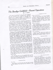
Map - RED WHITE AND BLUE EXTENDED MINE, 5/12/1940
... ...J.J. Caldwell... (9 Copies). By J.J. Caldwell, District Field Geologist, Mines Department Bendigo 5.12.1940...By J.J. Caldwell, District Field Geologist, Mines Department Bendigo 5.12.1940 Map RED WHITE AND BLUE EXTENDED MINE ...Map: Transverse section of The Red, White and Blue Extended Mine, Sheepshead line of Reef, Bendigo. (9 Copies). By J.J. Caldwell, District Field Geologist, Mines Department Bendigo 5.12.1940map, bendigo, mining plan, red white and blue extended mine, sheepshead line of reef, mining , gold mines, j.j. caldwell -
 Bendigo Historical Society Inc.
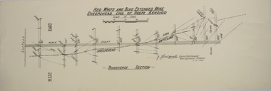
Plan - Napoleon, Nell Gwynne Transverse Section, 14.1.1946
... ...J.J. Caldwell...Printed on bottom of plan" Transverse Section Napoleon and Nell Gwynne Lines of Reef' and 'J.J. Caldwell, District Field Geologist, Mines Department, Bendigo. 14.1.46'. ...The no.10 (920 ft) south level connects with the main Napoleon shaft no.5 level (479 ft) appears to present the best opportunity for testing the prospects that are believed to have been inadequately investigated by the Bendigo Mines Limited in recent years. gold mining Bendigo Napoleon Gold Mine Nell Gwynne Reef lines J.J. Caldwell 1946 Map drawn on heavy paper. Printed on bottom of plan" Transverse Section Napoleon and Nell Gwynne Lines of Reef' and 'J.J. ...Napoleon Lease no.11111 is situated immediately south from the Golden Square railway station. It embraces an approx length of 36 chains of the Napoleon Anticline. The old Napoleon shaft, the depth of which is 1020 ft, occupies a central position in the area of about 43 acres. The accompanying sections, which are prepared from mine Managers plans, illustrate the extent of previous underground operations and indicate points at which future prospecting may be advantageously continued. The no.10 (920 ft) south level connects with the main Napoleon shaft no.5 level (479 ft) appears to present the best opportunity for testing the prospects that are believed to have been inadequately investigated by the Bendigo Mines Limited in recent years.Map drawn on heavy paper. Printed on bottom of plan" Transverse Section Napoleon and Nell Gwynne Lines of Reef' and 'J.J. Caldwell, District Field Geologist, Mines Department, Bendigo. 14.1.46'. Napoleon anticline and Central Nell Gwynne anticline marked on map. Map is part of the Margaret Roberts Collection of mining documents. gold mining, bendigo, napoleon gold mine, nell gwynne, reef lines, j.j. caldwell, 1946 -
 Bendigo Historical Society Inc.
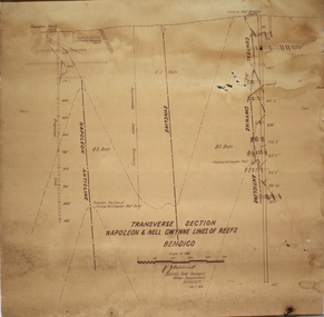
Plan - Central Deborah Gold Mine, J.J. Caldwell, 1945
... J.J. Caldwell...Plan Central Deborah Gold Mine J.J. Caldwell ...The Central Deborah Gold Mine is situated at 76 Violet Street, Bendigo. The mine operated from 1939 through to 1954 and extracted 929 kg of gold. The Central Deborah Gold Mine is a non-active gold mine and tourist attraction in Bendigo, Australia. It was listed on the Victorian Heritage Register on 18 November 1999.[1] The mine was opened in 1939 by the Central Deborah Gold Mining Company during a 1930s revival of the gold industry, extending an existing 108 ft shaft from many years earlier with new machinery. It was one of the last mines to open on the Bendigo goldfields and one of the few to stay open during World War II. It was expanded during 1945–46, with extensions and new machinery. It reached its maximum depth (now recorded as 412m) during the 1940s. It closed in November 1954, having produced 29,865 ounces of gold in its lifetime; the closure of the North Deborah Mine two weeks later marked the last mine in Bendigo to close Central Deborah Gold Mine is now a tourist destination, operated by Bendigo Heritage Attractions: https://www.central-deborah.com/about-us/central-deborah-gold-mine-s-history Blue waxed paper, features on plan drawn in pale pink and blue, title written in black text on centre bottom: 'Plan, Central Deborah Mine, Deborah Line of Reef, Bendigo, Scale 30 ft = 1 in.' Signature of J.J. Caldross, 13.10.45, written below name of mine. Handwritten on outside of plan in black pen: 'Mines Department, Cent. Deborah, Transverse section, Plan of levels' Plan notation shows No. 8 level on east leg of inner reef, level of east leg on outer reef, outer back, west leg, main shaft, numbers 5, 6, 7 and 10 levels. Mine map is part of the Margaret Roberts Collection. gold mining, gold, margaret roberts collection, central deborah gold mine, violet street, tourist attraction, bendigo -
 Bendigo Historical Society Inc.
Document - Kangaroo Flat Gold Mine Collection: Mining Journal, J.J. Caldwell, September 1940
... J.J. Caldwell...Document Kangaroo Flat Gold Mine Collection: Mining Journal J.J. Caldwell ...Four page photocopy of the 'Mining Journal, The Mining Industry's Weekly Newspaper', January 12, 2007. Main article, 'Bendigo goes into reverse' ,Rod Hanson, Bendigo's new CEO. Article 'fifth column' details Doug Buerger twelve years on the Bendigo Gold project and his resignation due to health and personal reasons.bendigo mining n.l., bendigo, mining, gold, kangaroo flat, doug buerger, rod hanson, mining journal, gary johansen -
 Bendigo Historical Society Inc.
Plan - Part of Napoleon and Nell Gwynne Reefs
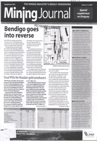
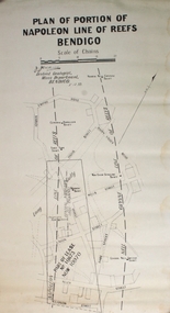
... ...J.J. Caldwell...Caldwell, Officer in charge of the Bendigo Geological branch of the Victorian Mines Department, received his early training in the Castlemaine and Bendigo Schools of Mines and later at the Melbourne Technical College Bendigo Margaret Roberts gold Map Mine Long Gully J.J. Caldwell Black printing on off white colored paper- PLAN OF PORTION OF NAPOLEON LINE OF REEFS BENDIGO, Scale of Chains, a signature, District Geologist Mines Department BENDIGO. 5/12/39 Two vertical broken lines are labeled NAPOLEON LINE OF REEFS, NELL GYWNNE LINE OF REEFS and CENTRAL NAPOLEON LODE CHANNEL and mine shafts CENTRAL NAPOLEON, MOONTA, PTOPOSED NEW SHAFT, NORTH NEW GWYNNE, THREE TOMS, NEW CHUM SYNCLINE and CENTRAL NELL GWYNNE are drawn over a street map of the Long Gully area. ...Mr. J. J. Caldwell, Officer in charge of the Bendigo Geological branch of the Victorian Mines Department, received his early training in the Castlemaine and Bendigo Schools of Mines and later at the Melbourne Technical CollegeBlack printing on off white colored paper- PLAN OF PORTION OF NAPOLEON LINE OF REEFS BENDIGO, Scale of Chains, a signature, District Geologist Mines Department BENDIGO. 5/12/39 Two vertical broken lines are labeled NAPOLEON LINE OF REEFS, NELL GYWNNE LINE OF REEFS and CENTRAL NAPOLEON LODE CHANNEL and mine shafts CENTRAL NAPOLEON, MOONTA, PTOPOSED NEW SHAFT, NORTH NEW GWYNNE, THREE TOMS, NEW CHUM SYNCLINE and CENTRAL NELL GWYNNE are drawn over a street map of the Long Gully area. The streets shown are; Empire Rd, Harvey St, Inglis St, Wells St, Union St, Alley St (now Marong Rd) and Curnow St. Forms part of the Margaret Roberts Collection bendigo, margaret roberts, gold, map, mine, long gully, j.j. caldwell -
 Bendigo Historical Society Inc.
Document - MCCOLL, RANKIN AND STANISTREET COLLECTION: NAPOLEON REEF GOLD MINING CO. N.L, 5 December 1939
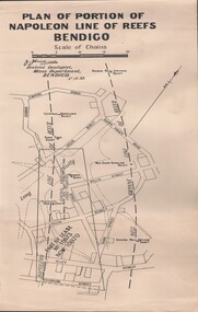
... Document: 4 Copies of plans showing part of lease No. 10970 (was 10873) and Central Napoleon Lode Channel, prepared by J.J. Caldwell District Geologist, Mines Dept, Bendigo 5th Dec 1939....History House 11 Mackenzie Street Bendigo goldfields ORGANIZATION Business industrial - mining McColl Rankin & Stanistreet mining gold mining Napoleon Reef Document: 4 Copies of plans showing part of lease No. 10970 (was 10873) and Central Napoleon Lode Channel, prepared by J.J. Caldwell District Geologist, Mines Dept, Bendigo 5th Dec 1939. ...Document: 4 Copies of plans showing part of lease No. 10970 (was 10873) and Central Napoleon Lode Channel, prepared by J.J. Caldwell District Geologist, Mines Dept, Bendigo 5th Dec 1939.organization, business, industrial - mining, mccoll rankin & stanistreet, mining, gold mining, napoleon reef -
 Bendigo Historical Society Inc.
Document - MCCOLL, RANKIN AND STANISTREET COLLECTION: NAPOLEON REEF GOLD MINING CO. N.L, 1940
... Document: 4 copies of plan of Transverse Section of Napoleon Anticline Lease no 10970, plan shows proposed shaft location and depth (1000 ft), for Napoleon Reef Gold Mining Co, also location and depth of adjacent Central Nell Gwynne Shaft scale 100ft = 1 inch, Prepared by J.J. Caldwell Mines Dept Bendigo....History House 11 Mackenzie Street Bendigo goldfields ORGANIZATION Business industrial - mining McColl Rankin & Stanistreet mining gold mining Napoleon Reef Document: 4 copies of plan of Transverse Section of Napoleon Anticline Lease no 10970, plan shows proposed shaft location and depth (1000 ft), for Napoleon Reef Gold Mining Co, also location and depth of adjacent Central Nell Gwynne Shaft scale 100ft = 1 inch, Prepared by J.J. Caldwell Mines Dept Bendigo. Document MCCOLL, RANKIN AND STANISTREET COLLECTION: NAPOLEON REEF GOLD MINING CO. ...Document: 4 copies of plan of Transverse Section of Napoleon Anticline Lease no 10970, plan shows proposed shaft location and depth (1000 ft), for Napoleon Reef Gold Mining Co, also location and depth of adjacent Central Nell Gwynne Shaft scale 100ft = 1 inch, Prepared by J.J. Caldwell Mines Dept Bendigo.organization, business, industrial - mining, mccoll rankin & stanistreet, mining, gold mining, napoleon reef -
 Bendigo Historical Society Inc.
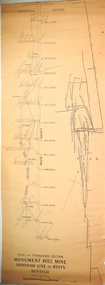
Plan - Monument Hill Gold Mine, 6.11.39
... Written on bottom of plan: 'Plan and transverse section, Monument Hill Mine, Deborah Line of Reefs, Bendigo' Handwritten on bottom of plan: 'J.J. Caldwell, 6.11.39'. Plan forms part of the Margaret Roberts Collection....Written on bottom of plan: 'Plan and transverse section, Monument Hill Mine, Deborah Line of Reefs, Bendigo' Handwritten on bottom of plan: 'J.J. Caldwell, 6.11.39'. Plan forms part of the Margaret Roberts Collection. ...Monument Hill Gold Mine was located near the corner of Old Violet and Olive Streets, Bendigo. It operated until 1947. The shaft was capped, the poppet legs and mullock removed. A house now occupies the site. The Monument Hill Gold mine depth was over 1200 ft. Detailed transverse plan of Monument Hill Mine, showing main shaft and levels. Plan of underground workings alongside section. Written on bottom of plan: 'Plan and transverse section, Monument Hill Mine, Deborah Line of Reefs, Bendigo' Handwritten on bottom of plan: 'J.J. Caldwell, 6.11.39'. Plan forms part of the Margaret Roberts Collection.gold mining, gold, bendigo, transverse, monument hill gold mine -
 Bendigo Historical Society Inc.
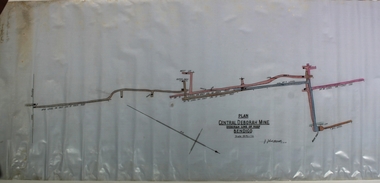
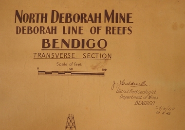
Plan - North Deborah Mine, 28.4.40 and 10.2.42
... Written on top in bold black text: ' North Deborah Mine, Deborah Line of Reef, Bendigo, Transverse Section' Signed by J.J. Caldwell. Printed under name: 'District Field Geologist, Department of Mines, Bendigo' 28.4.40 and 10.2.42, printed under title. ...Written on top in bold black text: ' North Deborah Mine, Deborah Line of Reef, Bendigo, Transverse Section' Signed by J.J. Caldwell. Printed under name: 'District Field Geologist, Department of Mines, Bendigo' 28.4.40 and 10.2.42, printed under title. ...North Deborah Gold Mine was located near Eve Street and Breen Street, Golden Square. :The company occupying this site was the leading gold producer of the Deborah line of reef during the 1930's mining revival period. The site is reserved for mining, contains the only brick mine chimney still standing. It is readily accessible, is visible from the Deborah site, Chum Hill and various other places around central Bendigo, and has views both to Chum Hill and the Deborah site.Light tan heavy paper plan. Written on top in bold black text: ' North Deborah Mine, Deborah Line of Reef, Bendigo, Transverse Section' Signed by J.J. Caldwell. Printed under name: 'District Field Geologist, Department of Mines, Bendigo' 28.4.40 and 10.2.42, printed under title. Plan shows poppet head, shaft and levels. Plan forms part of the Margaret Roberts Collection.gold mining, gold, bendigo, north deborah gold mine, eve street, breen street, golden square, transverse section -
 Bendigo Historical Society Inc.
Document - TAMBOUR MAJOR MINE
... For example, record 1: Author Caldwell, J.J. Melbourne Geological Survey of Victoria 1946 3 figs, 3 microfiche frames, 2 negatives. ...For example, record 1: Author Caldwell, J.J. Melbourne Geological Survey of Victoria 1946 3 figs, 3 microfiche frames, 2 negatives. ...Six page document describing resources found in a search for 'Tambour major' and 'Mine' with Informit databaxse, VPI&E (formerly ELIXIR) and AESIS Databases. For example, record 1: Author Caldwell, J.J. Melbourne Geological Survey of Victoria 1946 3 figs, 3 microfiche frames, 2 negatives. Subject: Bendigo Major Mine, transverse section.bendigo, mining, tambour major -
 8th/13th Victorian Mounted Rifles Regimental Collection
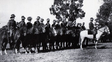
Photograph - Tallangatta Troop 8 LH Hutton Trophy winners
... J.J. Moyle, B. Kennedy, N. Stevenson, G. Agar, M. Paton, M. Caldwell, G. Morley, F. ...J.J. Moyle, B. Kennedy, N. Stevenson, G. Agar, M. Paton, M. Caldwell, G. Morley, F. ...The Tallangatta Troop, 8th Light horse Regiment won the Hutton Trophy in 1938.The 8th Light Horse (Indi) Regiment superseded the 16th Light Horse in 1919. It had its headquarters at Benalla with sub-units throughout the Upper Murray and Northeast Victoria. In December 1941,the regiment converted from horse to mechanised, initially as 8th Reconnaissance Battalion then in July 1942 it became 8th Cavalry Regiment and served in Northern Territory. As Japanese threat to the mainland declined the regiment was disbanded. The Hutton Trophy or Shield was awarded annually to the best Light Horse Troop in Ausralia. The trophy is now held at the Armoured Centre, Puckapunyal.Shows Citizen soldiers from North East Victoria.Black and white photograph of officer and men of Tallangatta Troop 8th Light Horse Regiment.Names : Lt. L Wildsmith, J.J. Moyle, B. Kennedy, N. Stevenson, G. Agar, M. Paton, M. Caldwell, G. Morley, F. Paton." Tallangatta Troop 8th Light Horse Regiment on winning Hutton trophy 1938. Wyeeboo Reserve " Also list of names.