Showing 3 items matching "kellett contractors"
-
 City of Ballarat Libraries
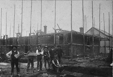
Photograph - Card Box Photographs, Kellett Contractors building the Market Hotel circa 1910
... Kellett Contractors building the Market Hotel circa 1910....Kellett Contractors...Brooks also on the Arch of Victory. Kellett Contractors Market Hotel Joe Kellett George Brooks Sam Turner Construction Work Persons Kellett Contractors building the Market Hotel circa 1910. ...Shows Joe Kellett, George Brooks bricklayer (With arms folded) and Sam Turner on left. Brooks also on the Arch of Victory.kellett contractors, market hotel, joe kellett, george brooks, sam turner, construction, work, persons -
 Bendigo Military Museum
Photograph - Christmas Children’s Party - Army Survey Regiment, Fortuna, Bendigo, 1992
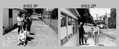
... They are part of the Army Survey Regiment’s Collection. .1) - Photo, black & white, 1992, unidentified civilians and person. .2) - Photo, black & white, 1992, SGT Brian Fauth, SPR Carmel (Butler) Fauth and their child. .3) - Photo, black & white, 1992, L to R: SPR Joyce Gray, unidentified, SPR Andrew Arman. .4) to .5) - Photo, black & white, 1992, unidentified. .6) - Photo, black & white, 1992, Craig Kellett. .7) - Photo, black & white, 1992, L to R: Cam Bramich, unidentified (x2). .8) to.10) - Photo, black & white, 1992, unidentified. .11) to .15) - Photo, black & white, 1992, unidentified catering staff and contractors. .16) - Photo, black & white, 1992, Children’s rides on parade ground....They are part of the Army Survey Regiment’s Collection. .1) - Photo, black & white, 1992, unidentified civilians and person. .2) - Photo, black & white, 1992, SGT Brian Fauth, SPR Carmel (Butler) Fauth and their child. .3) - Photo, black & white, 1992, L to R: SPR Joyce Gray, unidentified, SPR Andrew Arman. .4) to .5) - Photo, black & white, 1992, unidentified. .6) - Photo, black & white, 1992, Craig Kellett. .7) - Photo, black & white, 1992, L to R: Cam Bramich, unidentified (x2). .8) to.10) - Photo, black & white, 1992, unidentified. .11) to .15) - Photo, black & white, 1992, unidentified catering staff and contractors. .16) - Photo, black & white, 1992, Children’s rides on parade ground. ...This set of 16 photos of the Christmas Children’s Party were taken in the and the grounds of Fortuna, Army Survey Regiment in 1992. The Christmas party was an annual event enjoyed by the soldiers’ families, featuring amusements such as the ‘pig train’ and pony rides, a historic fire engine provided by the Golden Square Fire Brigade with Santa on board and refreshments such as cordial, lollies, ice creams and fairy floss. Single members readily volunteered to assist in the running of the party. An occasional highlight was displays of military hardware such as tanks and APC from the Puckapunyal’s Armoured Centre. Catering staff/contractors taking a break outside the kitchen are also featured in this collection. The Army Survey Regiment Wives Club was instrumental in establishing the Tennis Hut, featuring in photos .1P to .5P. The Wives Club initiated many social events. Examples of activities initiated by the club and their importance to the social fabric of the unit are described in more detail on page 151 of Valerie Lovejoy’s book 'Mapmakers of Fortuna – A history of the Army Survey Regiment’ ISBN: 0-646-42120-4.This set of 16 photos were taken in the grounds and kitchen area of Fortuna, Army Survey Regiment, Bendigo, at Christmas time in 1992. The photographs are on 35mm negative film and were scanned at 96 dpi. They are part of the Army Survey Regiment’s Collection. .1) - Photo, black & white, 1992, unidentified civilians and person. .2) - Photo, black & white, 1992, SGT Brian Fauth, SPR Carmel (Butler) Fauth and their child. .3) - Photo, black & white, 1992, L to R: SPR Joyce Gray, unidentified, SPR Andrew Arman. .4) to .5) - Photo, black & white, 1992, unidentified. .6) - Photo, black & white, 1992, Craig Kellett. .7) - Photo, black & white, 1992, L to R: Cam Bramich, unidentified (x2). .8) to.10) - Photo, black & white, 1992, unidentified. .11) to .15) - Photo, black & white, 1992, unidentified catering staff and contractors. .16) - Photo, black & white, 1992, Children’s rides on parade ground.No personnel are identified.royal australian survey corps, rasvy, army survey regiment, army svy regt, fortuna, asr -
 Kew Historical Society Inc
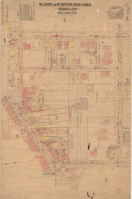
Plan, Melbourne and Metropolitan Board of Works, Borough of Kew : Detail Plan No.1580, 1904
... contractor on this plan are particularly detailed. Pink borders delineate the ownership of the varying parcels of land. Some of the better known owners listed include the real estate agent Cr. Henry de Castres Kellett...contractor on this plan are particularly detailed. Pink borders delineate the ownership of the varying parcels of land. Some of the better known owners listed include the real estate agent Cr. Henry de Castres Kellett ...The Melbourne and Metropolitan Board of Works (MMBW) plans were produced from the 1890s to the 1950s. They were crucial to the design and development of Melbourne's sewerage and drainage system. The plans, at a scale of 40 feet to 1 inch (1:480), provide a detailed historical record of Melbourne streetscapes and environmental features. Each plan covers one or two street blocks (roughly six streets), showing details of buildings, including garden layouts and ownership boundaries, and features such as laneways, drains, bridges, parks, municipal boundaries and other prominent landmarks as they existed at the time each plan was produced. (Source: State Library of Victoria)This plan forms part of a large group of MMBW plans and maps that was donated to the Society by the Mr Poulter, City Engineer of the City of Kew in 1989. Within this collection, thirty-five hand-coloured plans, backed with linen, are of statewide significance as they include annotations that provide details of construction materials used in buildings in the first decade of the 20th century as well as additional information about land ownership and usage. The copies in the Public Record Office Victoria and the State Library of Victoria are monochrome versions which do not denote building materials so that the maps in this collection are invaluable and unique tools for researchers and heritage consultants. A number of the plans are not held in the collection of the State Library of Victoria so they have the additional attribute of rarity.Original survey plan, issued by the MMBW to a contractor with responsibility for constructing sewers in the area identified on the plan within the Borough of Kew. The plan was at some stage hand-coloured, possibly by the contractor, but more likely by officers working in the Engineering Department of the Borough and later Town, then City of Kew. The hand-coloured sections of buildings on the plan were used to denote masonry or brick constructions (pink), weatherboard constructions (yellow), and public buildings (grey). The area represented in this detail plan has undergone significant change during the 20th century. The widening of High Street in the 1930s and 1950s involved the shops on the south side of High Street being demolished and later rebuilt to fit the widened street. Another significant loss was the mansion ‘Drayton’ fronting Wellington Street, owned at this stage by Susannah Fenton. Her family name would later to be given to Fenton Way, which was to be built over the grounds of the house following its demolition. The plan of the garden is particularly interesting, containing a batten dome fronting Wellington Street, an ornamental pond, a fountain and a brick and glass conservatory. The notes by the plumbing contractor on this plan are particularly detailed. Pink borders delineate the ownership of the varying parcels of land. Some of the better known owners listed include the real estate agent Cr. Henry de Castres Kellett (bt) and John Padbury, the funeral director. This particular plan provides a clear view of the configuration of the Kew Junction in 1903 and the commercial buildings that surrounded it.melbourne and metropolitan board of works, detail plans, maps - borough of kew, mmbw 1580, cartography