Showing 31 items matching "kew golf course"
-
 Kew Historical Society Inc
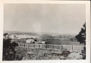
Photograph - Yarra in Flood - Belford & Kilby Farms, 1903
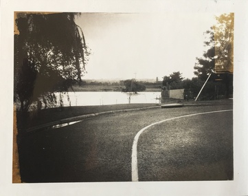
... ...kew golf course...Apart from some development on higher ground, the City of Kew regularly introduced restrictions on development and the building of housing in the area because of flood levels. floods -- yarra -- 1903 kew golf course greenacres golf course Panoramic photographic positive of North Kew where the Belford and Kilby Farms were located on the south side of the Yarra River. ...The Yarra Valley in what was previously called North Kew, but is now East Kew, was frequently subjected to flooding. Apart from some development on higher ground, the City of Kew regularly introduced restrictions on development and the building of housing in the area because of flood levels. Panoramic photographic positive of North Kew where the Belford and Kilby Farms were located on the south side of the Yarra River. This photo is a copy of the original photo in the collection.floods -- yarra -- 1903, kew golf course, greenacres golf course -
 Kew Historical Society Inc
Archive (Sub-series) - Subject File, Kew Historical Society, HODDLE Survey, 1997
... Much of the correspondence relates to the site of the ‘Hoddle Tree’, currently located in the Kew Golf Course. Jack Hackett’s original map is contained in the map drawers in the Society’s archive. ...Much of the correspondence relates to the site of the ‘Hoddle Tree’, currently located in the Kew Golf Course. Jack Hackett’s original map is contained in the map drawers in the Society’s archive. ...Various partiesReference, Research, InformationSecondary Values (KHS Imposed Order)Photocopied correspondence and maps (surveys) relating to surveys ordered by Robert Hoddle, Government Surveyor. Authors of letters and information include Gwen McWilliam and Jack Hackett. Much of the correspondence relates to the site of the ‘Hoddle Tree’, currently located in the Kew Golf Course. Jack Hackett’s original map is contained in the map drawers in the Society’s archive.kew historical society - archives, kew (vic) - history, robert hoddle - surveyor, hoddle tree - kew (vic), jack hackettkew historical society - archives, kew (vic) - history, robert hoddle - surveyor, hoddle tree - kew (vic), jack hackett -
 Kew Historical Society Inc
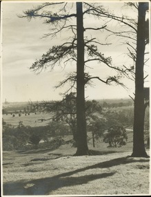
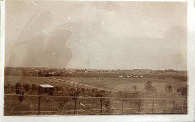
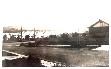
Photograph - Golf course viewed from East Kew, 1940s?
... Golf course viewed from East Kew...Kew (Vic.)...Latrobe Golf Course...Undated but possibly 1930s. Kew (Vic.) Latrobe Golf Course Inscribed reverse: "M Holmes" View of Latrobe Course from the Kew side of the River Yarra. ...Landscape photograph of Kew and Fairfield. Undated but possibly 1930s.View of Latrobe Course from the Kew side of the River Yarra. River in middle foreground. Aged pine tree central foreground. Inscribed reverse: "M Holmes"kew (vic.), latrobe golf course -
 Kew Historical Society Inc
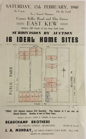
Plan - Subdivision Plan, Subdivision by Auction: 16 Ideal Home Sites, East Kew, 1940, 1940
... This significant sale of land between the Kew Golf Course and Willsmere Park led to the streets having a high degree of architectural uniformity....This significant sale of land between the Kew Golf Course and Willsmere Park led to the streets having a high degree of architectural uniformity. ...An advertisement for the sale of a subdivision by Auction: of 16 Ideal Home Sites, East Kew, 1940. This significant sale of land between the Kew Golf Course and Willsmere Park led to the streets having a high degree of architectural uniformity.The subdivision in the second year of the war indicates that land sales for homes and speculation continued from the 1930s into the period of the Second World War. There is no indication on the plan that a war is occurring.Single page subdivision plan advertising the sale by Auction of 16 Ideal Home Sites, in East Kew, on 17 February 1940. Streets named in the plan include: Kilby Road, Belford Road, Elm Grove, Willow Grove. Willsmere Park is indicated but not named. The auction was conducted by Beauchamp Brothers. A number of lots are coloured pink on the plan indicating those lots for sale and/or those already sold.subdivision plans - kew east (vic) -
 Kew Historical Society Inc
Photograph - Photograph (copy), Kanes Bridge, Studley Park, 195-1955
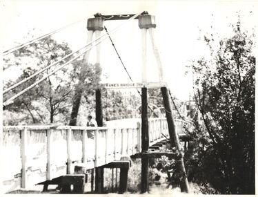
... In 1928 a footbridge was erected to link Kew with the public golf course across the Yarra. The total cost of construction came to 250 pounds and the bridge became known as Kane's Bridge. ...Kew Historical Society Inc Kew Court House 188 High Street Kew melbourne In 1928 a footbridge was erected to link Kew with the public golf course across the Yarra. The total cost of construction came to 250 pounds and the bridge became known as Kane's Bridge. ...In 1928 a footbridge was erected to link Kew with the public golf course across the Yarra. The total cost of construction came to 250 pounds and the bridge became known as Kane's Bridge. During the 1934 floods the bridge was washed downstream, and was subsequently rebuilt. The present form of the bridge resembles the earlier bridge which crossed from the Yarra Bend Asylum to Kew, further upstream. (VHD)This work forms part of the collection assembled by the historian Dorothy Rogers, that was donated to the Kew Historical Society by her son John Rogers in 2015. The manuscripts, photographs, maps, and documents were sourced by her from both family and local collections or produced as references for her print publications. Many were directly used by Rogers in writing ‘Lovely Old Homes of Kew’ (1961) and 'A History of Kew' (1973), or the numerous articles on local history that she produced for suburban newspapers. Most of the photographs in the collection include detailed annotations in her hand. The Rogers Collection provides a comprehensive insight into the working habits of a historian in the 1960s and 1970s. Together it forms the largest privately-donated collection within the archives of the Kew Historical Society.A photographic copy of an older photograph of Kanes Bridge."Kanes Bridge"kanes bridge, yarra river, bridges - kew (vic.) -
 Kew Historical Society Inc
Photograph - Kane's Bridge destroyed by the 1934 Flood, 1934
... In 1928 a footbridge was erected to link Kew with the public golf course across the Yarra. The total cost of construction came to 250 pounds and the bridge became known as Kane's Bridge. ...Kew Historical Society Inc Kew Court House 188 High Street Kew melbourne In 1928 a footbridge was erected to link Kew with the public golf course across the Yarra. The total cost of construction came to 250 pounds and the bridge became known as Kane's Bridge. ...In 1928 a footbridge was erected to link Kew with the public golf course across the Yarra. The total cost of construction came to 250 pounds and the bridge became known as Kane's Bridge. During the 1934 floods the bridge was washed downstream, and was subsequently rebuilt. The present form of the bridge resembles the earlier bridge which crossed from the Yarra Bend Asylum to Kew, further upstream. (VHD)Black and white positive print (identical to 2021.70 but with a different annotation) showing the destruction of Kane's Bridge in the floods of 1934. The Kodak paper would indicate a 1950s reprinting.Annotation verso: "Kane's Bridge in 1934 flood / Dec. 1934.kane's bridge, river yarra, yarra valley, 1934 floods -
 Kew Historical Society Inc
Photograph - Kane's Bridge on the Yarra River, December 1934
... In 1928 a footbridge was erected to link Kew with the public golf course across the Yarra. The total cost of construction came to 250 pounds and the bridge became known as Kane's Bridge. ...Kew Historical Society Inc Kew Court House 188 High Street Kew melbourne In 1928 a footbridge was erected to link Kew with the public golf course across the Yarra. The total cost of construction came to 250 pounds and the bridge became known as Kane's Bridge. ...In 1928 a footbridge was erected to link Kew with the public golf course across the Yarra. The total cost of construction came to 250 pounds and the bridge became known as Kane's Bridge. During the 1934 floods the bridge was washed downstream, and was subsequently rebuilt. The present form of the bridge resembles the earlier bridge which crossed from the Yarra Bend Asylum to Kew, further upstream. (VHD)Original, black and white positive of Kane's Bridge in December 1934, when the 'great flood' of the Yarra caused the bridge's destruction. Inscribed verso: "Kane's Bridge Yarra in flood Dec 1934"river yarra, yarra -- kew (vic.), kanes bridge, 1934 floods -
 Heidelberg Golf Club
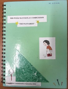
Administrative record - Book, Heidelberg Golf Club, Heidelberg Ladies Pennant mid-week match play "The Wannabees", 2002-2012: Ladies Pennant Book 11, 2002-2012
... Original handwritten names and results of HGC competing in the Yarra courses mid-week match play competition between Rosanna, Heidelberg, Latrobe, Kew, Greenacres and Yarra Valley Golf Clubs, 2002-2012...Heidelberg Golf Club 8 Main Road Lower Plenty 3093 Original handwritten names and results of HGC competing in the Yarra courses mid-week match play competition between Rosanna, Heidelberg, Latrobe, Kew, Greenacres and Yarra Valley Golf Clubs, 2002-2012 Volume 11 of a set of women's pennant results Women's Golf Associates Ladies' Golf Pennant Green spiral bound hardcover notebook. ...Original handwritten names and results of HGC competing in the Yarra courses mid-week match play competition between Rosanna, Heidelberg, Latrobe, Kew, Greenacres and Yarra Valley Golf Clubs, 2002-2012Volume 11 of a set of women's pennant resultsGreen spiral bound hardcover notebook. Handwritten and typed results pasted into book.women's golf, associates, ladies' golf, pennant -
 Kew Historical Society Inc
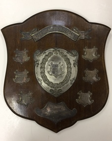
Award, Mental Hospitals Ladies Golf Competition, Commemorative Shield, 1930-1932
... The Golf Club was established in 1928, and was owned and managed as part of the Kew Mental Hospital. The 9-hole golf course was located next to the Chandler Highway and is currently the site of the headquarters of Guide Dogs Victoria. ...The Golf Club was established in 1928, and was owned and managed as part of the Kew Mental Hospital. The 9-hole golf course was located next to the Chandler Highway and is currently the site of the headquarters of Guide Dogs Victoria. ...An Article in The Herald (18 Feb 1931) records that: "FAIRVIEW OFFICIALS - AT the annual meeting of the Associates of the Fairview Golf Club the following office bearers were elected: President, Miss A, Simcocks; secretary, Miss B. Williamson; captain, Miss A. Shiells; committee, Misses Tresise, Walters, Brown and McLachlan. The captain reported that the shield presented by Mr and Mrs Bourne for competition among the clubs associated with the metropolitan mental hospitals had been won by Fairview associates, who will hold it for one year."The trophy has historical significance as an item associated with the Melbourne Mental Hospital in the 1930s and also of social significance in that it relates to recreational pursuits undertaken by staff of the Hospital.Wood and silver plate shield won by the ladies team of Fairview Golf Club in the years 1930, 1931 and 1932. The Golf Club was established in 1928, and was owned and managed as part of the Kew Mental Hospital. The 9-hole golf course was located next to the Chandler Highway and is currently the site of the headquarters of Guide Dogs Victoria. The trophy formed part of the personal collection of Dr Fred Stamp, which was donated to the Kew Historical Society following his death in 2018 by his family.Inscriptions on silver plate plaques - Top "Mental Hospitals", Bottom: "Ladies Golf Competition"; Bottom left: "Fairview Golf Club 1930", "Fairview Golf Club 1931" and Fairview Golf Club 1932".fairview golf club, golf - womens competitions - victoria, trophies - golf -
![Discover Australia's Golf Courses / [by] Tom Ramsey](/media/collectors/550653872162f11fb04854aa/items/5d0347b921ea7b095052afad/item-media/5ebc91aea9d32b09e4a4de26/item-fit-380x285.jpg?cb=6) Kew Historical Society Inc
Kew Historical Society IncBook, Discover Australia's Golf Courses / [by] Tom Ramsey, 1987
... Kew Historical Society Inc Kew Court House 188 High Street Kew melbourne goldf courses - australia 231 p. : col. ill., maps Discover Australia's Golf Courses / [by] Tom Ramsey Book Book Dent ...231 p. : col. ill., mapsgoldf courses - australia -
 Kew Historical Society Inc
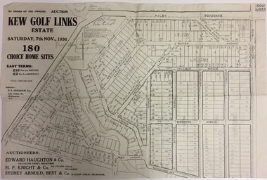
Plan - Subdivision Plan, Kew Golf Links Estate, 1936, 1936
... Kew Golf Links Estate was a major subdivision in North Kew. It derived its title due to the land being previously occupied by the Kew Golf Club, which transferred its course to a number of locations before occupying its current site. ...Kew Golf Links Estate was a major subdivision in North Kew. It derived its title due to the land being previously occupied by the Kew Golf Club, which transferred its course to a number of locations before occupying its current site. ...The Kew Golf Links Estate was a major subdivision in North Kew. It derived its title due to the land being previously occupied by the Kew Golf Club, which transferred its course to a number of locations before occupying its current site. The Plan advertises 180 choice home sites. The street names are somewhat different today as those on the map are named after the proposed Kodak Factory to be built on the site. The subdivision of the Kew Golf Links Estate was a major subdivision of farmland in Kew. The site was at one stage designated for industrial development and the building of a new Kodak factory. The decision by Council to oppose the redevelopment makes the beginning of the period when all industrial development was banned in Kew.Monochrome printed, folded subdivision plan for the Kew Golf Links Estate, to be auctioned on 7 November 1936. Streets named include: Carnegie Avenue, Willsmere Road, Kilby Boulevarde, Kodak Avenue, Coleman Avenue, Beresford Avenue, McConchie Avenue, Cole Avenue, White Avenue, Baker Avenue, Spruzen Avenue, Tanner Avenue, Ratten Avenue, Mathers Avenue, Railway Avenue, Sutherland Avenue, and Belford Road. The position of the Yarra River and a large Drainage Reserve are marked on the plan. Lots for sale are numbered. Existing buildings are designated with a square.subdivision plans - kew (vic), kodak factory - kew (vic) -
Kew Historical Society Inc
Book, Joseph Johnson, Birdies and Billabongs: a history of the Kew Golf Club, 1894-1994, 1994
... Reference books have entered the collection through donation, presentation, collection and purchase. Kew Golf Club - History Golf courses - Victoria - Melbourne - History Golf - Victoria - Melbourne - History x, 206 p. : ill. ...x, 206 p. : ill. (some col.), maps, ports. ; 22 x 28 cm. non-fictionkew golf club - history, golf courses - victoria - melbourne - history, golf - victoria - melbourne - history -
 Kew Historical Society Inc
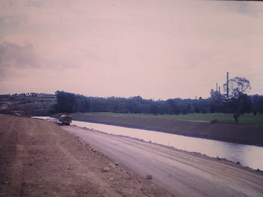
Photograph - Construction of the Eastern Freeway (F19), Ron Setford, November 1972
... Kew over a five year period from c.1972 to c.1977. This important collection was donated to the Society by his granddaughter in 2025. This collection of 175 35mm slides is of local and statewide significance, owing to its subject matter, particularly the major development of road transport infrastructure during the 1970s with the construction of the Eastern Freeway. The photographer also took care to annotate and date most of his slides which enable the researcher to pinpoint temporal and spatial locations. Ron Setford Eastern Freeway F19 Freeway "New river course / Latrobe golf ...Ron Setford and his wife Grace Setford lived in Tanner Avenue, East Kew, from c.1946 to c.1995. A keen photographer, he recorded the changing face of Kew over a 20 year period. Apart from 30 photographs of built structures and places in Kew dating from 1960 and 1961, 145 of his 35mm colour slides chronicle the development of the F19 (later renamed Eastern) Freeway through the Yarra Valley in Kew over a five year period from c.1972 to c.1977. This important collection was donated to the Society by his granddaughter in 2025.This collection of 175 35mm slides is of local and statewide significance, owing to its subject matter, particularly the major development of road transport infrastructure during the 1970s with the construction of the Eastern Freeway. The photographer also took care to annotate and date most of his slides which enable the researcher to pinpoint temporal and spatial locations."New river course / Latrobe golf club across river / Nov 72"ron setford, eastern freeway, f19 freeway -
Kew Historical Society Inc
Journal, Kewriosity : November 1991
... Kew Info Youth / p15. Local Artist [Mary McQueen] / p15. Golden putter golf [Studley Park Golf Course] / p15. ...The Horse Tram returns to Kew [Kew Depot Open Day] / p1. Chief Executive's Comment [Kew Junction] / Malcolm Hutchinson p2. Mayor's Comment [Kew Junction Strategy Plan] / Cr Daryl Oldaker p3. Diary Dates for November / p4. Diary Dates for December / p5. The Lioness Club of Kew / p5. Market [Kew Community House] / p5. Invitation to Lawn Bowls [Auburn Heights Bowling Club] / p5. Leader Sports Challenge Camp / p6. New face [Heather Crichton] / p7. New Way Theatre [Company][Kew Cottages] / p7. Safe disposal of chemicals around the home [Disposal options - Waste type by location] / p8. Insects / Marlowe p9. Bothered by pests? [Improved and cheap pest control for Kew residents] / p9. Kewriosity advertising rates / p10. City of Kew Waste Disposal Services for 1991/92 / Malcolm Hutchinson p11. New mum presentation [Nursing Mothers' Association; St George's Hospital] / p12. Kew Auxiliary - Royal Women's Hospital / p12. L.Bear [Library Bear] / p13. Arthritis self help / p14. Mural [by Bill Wood] / p14. Old Trams [request for photos] / p14. Kew Info Youth / p15. Local Artist [Mary McQueen] / p15. Golden putter golf [Studley Park Golf Course] / p15. City of Kew Residential Policies Review Committee [update] / p16. Apology [Kew Community House program] / p16.Kewriosity was a local newsletter combining Kew Council and community news. It was published between November 1983 and June 1994, replacing an earlier Kewriosity [broad] Sheet (1979-84). In producing Kewriosity, Council aimed to provide a range of interesting and informative articles covering its deliberations and decision making, together with items of general interest and importance to the Kew community and information not generally available through daily media outlets.non-fictionThe Horse Tram returns to Kew [Kew Depot Open Day] / p1. Chief Executive's Comment [Kew Junction] / Malcolm Hutchinson p2. Mayor's Comment [Kew Junction Strategy Plan] / Cr Daryl Oldaker p3. Diary Dates for November / p4. Diary Dates for December / p5. The Lioness Club of Kew / p5. Market [Kew Community House] / p5. Invitation to Lawn Bowls [Auburn Heights Bowling Club] / p5. Leader Sports Challenge Camp / p6. New face [Heather Crichton] / p7. New Way Theatre [Company][Kew Cottages] / p7. Safe disposal of chemicals around the home [Disposal options - Waste type by location] / p8. Insects / Marlowe p9. Bothered by pests? [Improved and cheap pest control for Kew residents] / p9. Kewriosity advertising rates / p10. City of Kew Waste Disposal Services for 1991/92 / Malcolm Hutchinson p11. New mum presentation [Nursing Mothers' Association; St George's Hospital] / p12. Kew Auxiliary - Royal Women's Hospital / p12. L.Bear [Library Bear] / p13. Arthritis self help / p14. Mural [by Bill Wood] / p14. Old Trams [request for photos] / p14. Kew Info Youth / p15. Local Artist [Mary McQueen] / p15. Golden putter golf [Studley Park Golf Course] / p15. City of Kew Residential Policies Review Committee [update] / p16. Apology [Kew Community House program] / p16.publications -- city of kew (vic.), kewriosity, council newsletters, community newsletters -
Kew Historical Society Inc
Journal, Kewriosity : September 1991
... Kew wins at golf [Studley Park Golf Course] / p7. The Mighty Lions of Kew [Lions Club of Kew] / p8. ...Is Kew a healthy community - have your say and win prizes / p1. Arthritis/Do you suffer / p1. Have a heart [National Heart Foundation Doorknock Appeal] / p1. Diary dates for September / p2. Swimming for older people [Kew Recreation Centre] / p2. Kew Bowling Club Invitation / p2. Commentary [Obituary for Cr Alfred Stevens; 120 Litre Mobile Bin Recycling Trial / Cr Daryl Oldaker p3. Chief Executive's Column [How Councils raise revenue] / Malcolm Hutchinson p3. Diary dates for October / p4. Kindergarten open days [Kew Preschool Association] / p4. Kew Festival [Kewmunity Living 1992] / p4. VicRoads competition / p4. Medical careers [St George's Hospital; Inner Eastern Geriatric Service] / p4. Kew Colts American Football Club / p4. Introducing Councillor John Vincent Murray [Studley Park Ward] / p5. Big print [books at Kew Library] / p5. So long, farewell [Tony Douglas Clerk of Works] / p5. Empress in Melbourne - 6th April 1938 [book] / p5. Spare time [Volunteering at Bodalla Hospital] / p5. Kew Scout Award [Queens Scout Duncan White] p6. Trinity Grammar prize winning students [Jerry Chiang] / p6. Young Women's Group / Sonia Lloyd p6. Advising Centre for women / p6. Carey Junior School / p7. 'How can you be boss of the bladder' [book] / p7. Swimming for intellectually disabled women [at Kew recreation Centre] / p7. Kew wins at golf [Studley Park Golf Course] / p7. The Mighty Lions of Kew [Lions Club of Kew] / p8. 'The Fabulous Nobody's Return' ['Godspell' at Kew High School Community Theatre] / p8. 'Dragon Girl' [at Kew High School Community Theatre] / p8. If not W.H.E.N.? [Worldwide Home Environmentalists Network] / p8.Kewriosity was a local newsletter combining Kew Council and community news. It was published between November 1983 and June 1994, replacing an earlier Kewriosity [broad] Sheet (1979-84). In producing Kewriosity, Council aimed to provide a range of interesting and informative articles covering its deliberations and decision making, together with items of general interest and importance to the Kew community and information not generally available through daily media outlets.non-fictionIs Kew a healthy community - have your say and win prizes / p1. Arthritis/Do you suffer / p1. Have a heart [National Heart Foundation Doorknock Appeal] / p1. Diary dates for September / p2. Swimming for older people [Kew Recreation Centre] / p2. Kew Bowling Club Invitation / p2. Commentary [Obituary for Cr Alfred Stevens; 120 Litre Mobile Bin Recycling Trial / Cr Daryl Oldaker p3. Chief Executive's Column [How Councils raise revenue] / Malcolm Hutchinson p3. Diary dates for October / p4. Kindergarten open days [Kew Preschool Association] / p4. Kew Festival [Kewmunity Living 1992] / p4. VicRoads competition / p4. Medical careers [St George's Hospital; Inner Eastern Geriatric Service] / p4. Kew Colts American Football Club / p4. Introducing Councillor John Vincent Murray [Studley Park Ward] / p5. Big print [books at Kew Library] / p5. So long, farewell [Tony Douglas Clerk of Works] / p5. Empress in Melbourne - 6th April 1938 [book] / p5. Spare time [Volunteering at Bodalla Hospital] / p5. Kew Scout Award [Queens Scout Duncan White] p6. Trinity Grammar prize winning students [Jerry Chiang] / p6. Young Women's Group / Sonia Lloyd p6. Advising Centre for women / p6. Carey Junior School / p7. 'How can you be boss of the bladder' [book] / p7. Swimming for intellectually disabled women [at Kew recreation Centre] / p7. Kew wins at golf [Studley Park Golf Course] / p7. The Mighty Lions of Kew [Lions Club of Kew] / p8. 'The Fabulous Nobody's Return' ['Godspell' at Kew High School Community Theatre] / p8. 'Dragon Girl' [at Kew High School Community Theatre] / p8. If not W.H.E.N.? [Worldwide Home Environmentalists Network] / p8.publications -- city of kew (vic.), kewriosity, council newsletters, community newsletters -
Kew Historical Society Inc
Booklet - Old Kew Golf Links Estate, 1926
... Kew Golf Club clubhouse, and 'The Moorings' Boathouse (aka Chipperfield's Boat House). The aerial photograph, overlaid with names of notable sites, on the final page is of interest as it shows the area before the intrusion of the Eastern Freeway, which resulted in changing the course of a section of the Yarra River. ...Kew Golf Club clubhouse, and 'The Moorings' Boathouse (aka Chipperfield's Boat House). The aerial photograph, overlaid with names of notable sites, on the final page is of interest as it shows the area before the intrusion of the Eastern Freeway, which resulted in changing the course of a section of the Yarra River. ...Subdivision plans and real estate flyers/brochures reveal a number of aspects of urban development and history. The Kew Historical Society's collection of these plans, as well as advertisements extracted from magazines, cover key aspects of community development and architectural history of Kew and Kew Eat as well as surrounding suburbs. While most of the plans in the collection were gifted to the Society by the former City of Kew, a number of other plans and advertisements have been donated by individuals, of which this is an example.8-page brochure advertising 80 residential home sites for sale in a subdivision called the 'Old Kew Golf Links Estate'. These sites had historic importance in Kew's history as they had previously belonged to Kodak Pty Ltd who were refused permission by Kew Council to use the land for industrial development. The estate, advertised was advertised as being within five miles of Melbourne. The brochure is notable as it includes photographs of Kew East Primary School, the former Kew Golf Club clubhouse, and 'The Moorings' Boathouse (aka Chipperfield's Boat House). The aerial photograph, overlaid with names of notable sites, on the final page is of interest as it shows the area before the intrusion of the Eastern Freeway, which resulted in changing the course of a section of the Yarra River. old kew golf links estate, subdivision -- kew (vic.), subdivisions -- kew east (vic), chipperfield's boathouse, kew east primary school, kew golf club -
Kew Historical Society Inc
Plan - 30 Choice Home Sites in Kilby Road, Meldrum Street and Fairway Drive, 1965
... Original 4-page, bifold brochure, one of two in the collection, of home sites created following the creation of the Eastern Freeway which separated a section of land owned by the Kew Golf Club from the main course. The new estate featured 30 lots in Meldrum Street, Kilby Road and Fairway Drive. ...Kew Golf Club Original 4-page, bifold brochure, one of two in the collection, of home sites created following the creation of the Eastern Freeway which separated a section of land owned by the Kew Golf Club from the main course. ...Subdivision plans and real estate flyers/brochures reveal a number of aspects of urban development and history. The Kew Historical Society's collection of these plans, as well as advertisements extracted from magazines, cover key aspects of community development and architectural history of Kew and Kew Eat as well as surrounding suburbs. While most of the plans in the collection were gifted to the Society by the former City of Kew, a number of other plans and advertisements have been donated by individuals, of which this is an example.Original 4-page, bifold brochure, one of two in the collection, of home sites created following the creation of the Eastern Freeway which separated a section of land owned by the Kew Golf Club from the main course. The new estate featured 30 lots in Meldrum Street, Kilby Road and Fairway Drive. subdivisions -- kew east (vic.), subdivisions -- kew (vic.), kew golf club -
Kew Historical Society Inc
Plan - 30 Choice Home Sites in Kilby Road, Meldrum Street and Fairway Drive, 1965
... Original 4-page, bifold brochure, one of two in the collection, of home sites created following the creation of the Eastern Freeway which separated a section of land owned by the Kew Golf Club from the main course. The new estate featured 30 lots in Meldrum Street, Kilby Road and Fairway Drive....While most of the plans in the collection were gifted to the Society by the former City of Kew, a number of other plans and advertisements have been donated by individuals, of which this is an example. subdivisions -- kew east (vic.) subdivisions -- kew (vic.) kew golf club Original 4-page, bifold brochure, one of two in the collection, of home sites created following the creation of the Eastern Freeway which separated a section of land owned by the Kew Golf Club from the main course. ...Subdivision plans and real estate flyers/brochures reveal a number of aspects of urban development and history. The Kew Historical Society's collection of these plans, as well as advertisements extracted from magazines, cover key aspects of community development and architectural history of Kew and Kew Eat as well as surrounding suburbs. While most of the plans in the collection were gifted to the Society by the former City of Kew, a number of other plans and advertisements have been donated by individuals, of which this is an example.Original 4-page, bifold brochure, one of two in the collection, of home sites created following the creation of the Eastern Freeway which separated a section of land owned by the Kew Golf Club from the main course. The new estate featured 30 lots in Meldrum Street, Kilby Road and Fairway Drive.subdivisions -- kew east (vic.), subdivisions -- kew (vic.), kew golf club -
 Kew Historical Society Inc
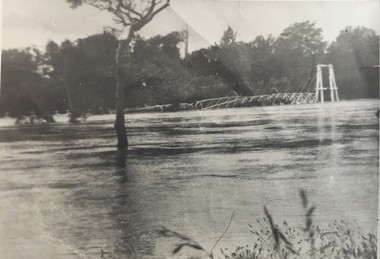
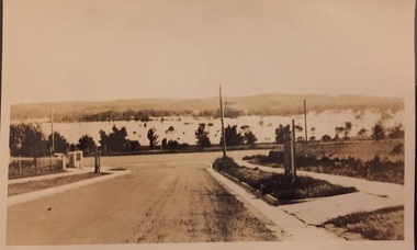
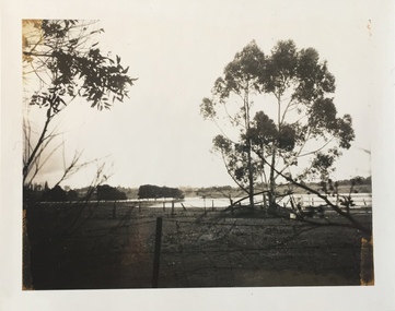
Photograph - Yarra Valley Floods: Kew East, 1916
... Kew was devoted to dairy farming. In the twentieth century, before and after the construction of the Eastern Freeway, much of this low-lying area was used as golf courses and public parks....Kew was devoted to dairy farming. In the twentieth century, before and after the construction of the Eastern Freeway, much of this low-lying area was used as golf courses and public parks. ...Flooding of the Yarra Valley, including that section of the Yarra bordering Kew and Kew East in the north and west of the municipality, was a regular occurrence. Extreme flood events of the Yarra River are recorded to have occurred in 1891, 1901, 1916, 1923 and 1934. The Municipality of Kew's response to these floods was to enact planning decisions restricting residential development in flood prone areas following the floods of 1916, 1921 and 1934. While floods continued after the development of the Upper Yarra Reservoir (construction 1948-57), the regularity and extent of these inundations diminished. During the nineteenth century, the land abutting the south side of the Yarra in Kew was devoted to dairy farming. In the twentieth century, before and after the construction of the Eastern Freeway, much of this low-lying area was used as golf courses and public parks.One of a collection of photographs of flooding in the Kew section of the Yarra Valley which are in important research resource for the location and extent of flooding in the first half of the twentieth century. Flooding of the Yarra Valley at East Kew in 1916. The view is taken from the intersection of Kilby Road with what is believed to be Birdwood Street, looking across the flood waters to Ivanhoe. The extensive flooded area shown in the photograph would have included the Kew Golf Club. Verso: "Floods along Kilby Road / near Birdwood St? & Kilby Road / 1917? / 87yarra river, yarra valley, floods -- kew, kilby road -- kew (vic.), kew golf club -
 Kew Historical Society Inc
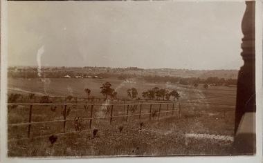
Photograph - Yarra Valley at Kew, 1918
... Kew was devoted to dairy farming. In the twentieth century, before and after the construction of the Eastern Freeway, much of this low-lying area was used as golf courses and public parks....Kew was devoted to dairy farming. In the twentieth century, before and after the construction of the Eastern Freeway, much of this low-lying area was used as golf courses and public parks. yarra river yarra valley Verso: "Willsmere / East Kew? ...During the nineteenth century, the land abutting the south side of the Yarra in Kew was devoted to dairy farming. In the twentieth century, before and after the construction of the Eastern Freeway, much of this low-lying area was used as golf courses and public parks.View of the farmland in the Yarra Valley at what is believed to be East Kew in 1918. Verso: "Willsmere / East Kew? / 1918"yarra river, yarra valley -
 Kew Historical Society Inc
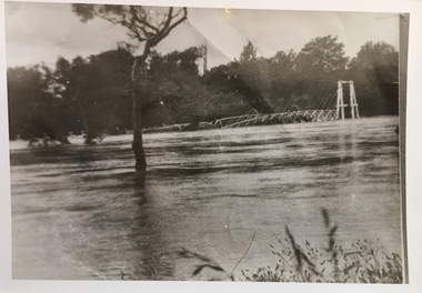
Photograph - Yarra Valley Floods: Kew East, 1916
... Kew was devoted to dairy farming. In the twentieth century, before and after the construction of the Eastern Freeway, much of this low-lying area was used as golf courses and public parks....Kew was devoted to dairy farming. In the twentieth century, before and after the construction of the Eastern Freeway, much of this low-lying area was used as golf courses and public parks. ...Flooding of the Yarra Valley, including that section of the Yarra bordering Kew and Kew East in the north and west of the municipality, was a regular occurrence. Extreme flood events of the Yarra River are recorded to have occurred in 1891, 1901, 1916, 1923 and 1934. The Municipality of Kew's response to these floods was to enact planning decisions restricting residential development in flood prone areas following the floods of 1916, 1921 and 1934. While floods continued after the development of the Upper Yarra Reservoir (construction 1948-57), the regularity and extent of these inundations diminished. During the nineteenth century, the land abutting the south side of the Yarra in Kew was devoted to dairy farming. In the twentieth century, before and after the construction of the Eastern Freeway, much of this low-lying area was used as golf courses and public parks.One of a collection of photographs of flooding in the Kew section of the Yarra Valley which are in important research resource for the location and extent of flooding in the first half of the twentieth century. Flooding of the Yarra Valley at East Kew in 1916. The view is taken from a street (maybe Birdwood Avenue) intersecting with Kilby Road looking northeast across the flood waters to Ivanhoe and Heidelberg. The extensive flooded area shown in the photograph would have included remnant dairy farms and the Kew Golf Club. Verso: "Floods / Yarra River / East Kew / Kilby Road / 1917? / 87"yarra river, yarra valley, floods -- kew, kilby road -- kew (vic.), kew golf club -
 Kew Historical Society Inc
Photograph - Yarra Valley at Kew, 1912
... Kew was devoted to dairy farming. In the twentieth century, before and after the construction of the Eastern Freeway, much of this low-lying area was used as golf courses and public parks....Kew was devoted to dairy farming. In the twentieth century, before and after the construction of the Eastern Freeway, much of this low-lying area was used as golf courses and public parks. yarra river yarra valley farming -- kew (vic.) ...During the nineteenth century, the land abutting the south side of the Yarra in Kew was devoted to dairy farming. In the twentieth century, before and after the construction of the Eastern Freeway, much of this low-lying area was used as golf courses and public parks.Real-photo postcard of the farmland in the Yarra Valley in what is believed to be North Kew in 1912. Verso: "Willsmere / East Kew / 1912"yarra river, yarra valley, farming -- kew (vic.) -
 Kew Historical Society Inc
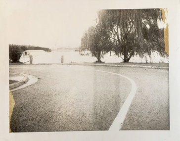
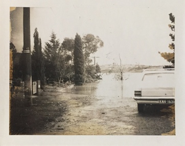
Photograph - Flooding of the Yarra Valley at Kew East, 1974
... Kew was devoted to dairy farming. In the twentieth century, before and after the construction of the Eastern Freeway, much of this low-lying area was used as golf courses and public parks....Kew was devoted to dairy farming. In the twentieth century, before and after the construction of the Eastern Freeway, much of this low-lying area was used as golf courses and public parks. ...Flooding of the Yarra Valley, including that section of the Yarra bordering Kew and Kew East in the north and west of the municipality, was a regular occurrence. Extreme flood events of the Yarra River are recorded to have occurred in 1891, 1901, 1916, 1923 and 1934. The Municipality of Kew's response to these floods was to enact planning decisions restricting residential development in flood prone areas following the floods of 1916, 1921 and 1934. While floods continued after the development of the Upper Yarra Reservoir (construction 1948-57), the regularity and extent of these inundations diminished. During the nineteenth century, the land abutting the south side of the Yarra in Kew was devoted to dairy farming. In the twentieth century, before and after the construction of the Eastern Freeway, much of this low-lying area was used as golf courses and public parks.Late example of the capacity of the Yarra Valley at Kew to flood, even though drainage works and the Upper Yarra Reservoir had reduced their regularity.Original black and white print photograph of the low-lying land at East Kew under floodwater on 16 May 1974. The vantage point of the photographer is Lister Street. In the photo, the fences of the Kilby Farm can be seen. Flooding was caused by overflowing water in Glass' Creek and the River Yarra. Annotation verso: "Hay's Paddock op No.30 Lister Street / 16 May 1974 11.50am / R.L. 46.04"hays paddock, floods, yarra river, glass' creek, lister street -
 Kew Historical Society Inc
Photograph - Flooding of the Yarra Valley at Kew East, 1974
... Kew was devoted to dairy farming. In the twentieth century, before and after the construction of the Eastern Freeway, much of this low-lying area was used as golf courses and public parks....Kew was devoted to dairy farming. In the twentieth century, before and after the construction of the Eastern Freeway, much of this low-lying area was used as golf courses and public parks. ...Flooding of the Yarra Valley, including that section of the Yarra bordering Kew and Kew East in the north and west of the municipality, was a regular occurrence. Extreme flood events of the Yarra River are recorded to have occurred in 1891, 1901, 1916, 1923 and 1934. The Municipality of Kew's response to these floods was to enact planning decisions restricting residential development in flood prone areas following the floods of 1916, 1921 and 1934. While floods continued after the development of the Upper Yarra Reservoir (construction 1948-57), the regularity and extent of these inundations diminished. During the nineteenth century, the land abutting the south side of the Yarra in Kew was devoted to dairy farming. In the twentieth century, before and after the construction of the Eastern Freeway, much of this low-lying area was used as golf courses and public parks.Late example of the capacity of the Yarra Valley at Kew to flood, even though drainage works and the Upper Yarra Reservoir had reduced their regularity.Original black and white print photograph of the low-lying land at East Kew under floodwater on 16 May 1974. The vantage point of the photographer is Lister Street. Flooding was caused by overflowing water in Glass' Creek and the River Yarra. Annotation verso: "Lister Street looking north / Flood level / 16 May 1974 11.30am / R.L. 46.04"hays paddock, floods, yarra river, glass' creek, lister street -
 Kew Historical Society Inc
Photograph - Flooding of the Yarra Valley at Kew East, 1974
... Kew was devoted to dairy farming. In the twentieth century, before and after the construction of the Eastern Freeway, much of this low-lying area was used as golf courses and public parks....Kew was devoted to dairy farming. In the twentieth century, before and after the construction of the Eastern Freeway, much of this low-lying area was used as golf courses and public parks. ...Flooding of the Yarra Valley, including that section of the Yarra bordering Kew and Kew East in the north and west of the municipality, was a regular occurrence. Extreme flood events of the Yarra River are recorded to have occurred in 1891, 1901, 1916, 1923 and 1934. The Municipality of Kew's response to these floods was to enact planning decisions restricting residential development in flood prone areas following the floods of 1916, 1921 and 1934. While floods continued after the development of the Upper Yarra Reservoir (construction 1948-57), the regularity and extent of these inundations diminished. During the nineteenth century, the land abutting the south side of the Yarra in Kew was devoted to dairy farming. In the twentieth century, before and after the construction of the Eastern Freeway, much of this low-lying area was used as golf courses and public parks.Late example of the capacity of the Yarra Valley at Kew to flood, even though drainage works and the Upper Yarra Reservoir had reduced their regularity.Original black and white print photograph of Hay's Paddock under floodwater on 16 May 1974. The vantage point of the photographer is Keystone Crescent looking east. Flooding was caused by overflowing water in Glass' Creek and the River Yarra. Annotation verso: "Keystone Cr looking east / 16 May 1974 11.50am"hays paddock, floods, yarra river, glass' creek -
 Kew Historical Society Inc
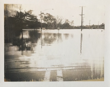
Photograph - Flooding of the Yarra Valley at Kew East, 1974
... Kew was devoted to dairy farming. In the twentieth century, before and after the construction of the Eastern Freeway, much of this low-lying area was used as golf courses and public parks....Kew was devoted to dairy farming. In the twentieth century, before and after the construction of the Eastern Freeway, much of this low-lying area was used as golf courses and public parks. ...Flooding of the Yarra Valley, including that section of the Yarra bordering Kew and Kew East in the north and west of the municipality, was a regular occurrence. Extreme flood events of the Yarra River are recorded to have occurred in 1891, 1901, 1916, 1923 and 1934. The Municipality of Kew's response to these floods was to enact planning decisions restricting residential development in flood prone areas following the floods of 1916, 1921 and 1934. While floods continued after the development of the Upper Yarra Reservoir (construction 1948-57), the regularity and extent of these inundations diminished. During the nineteenth century, the land abutting the south side of the Yarra in Kew was devoted to dairy farming. In the twentieth century, before and after the construction of the Eastern Freeway, much of this low-lying area was used as golf courses and public parks.Late example of the capacity of the Yarra Valley at Kew to flood, even though drainage works and the Upper Yarra Reservoir had reduced their regularity.Original black and white print photograph of the low-lying land at East Kew under floodwater on 16 May 1974. The vantage point of the photographer is Lister Street. Flooding was caused by overflowing water in Glass' Creek and the River Yarra. Annotation verso: "Lister St looking same as No.3 / 16 May 1974 11.30"floods, yarra river, glass' creek, lister street -
 Kew Historical Society Inc
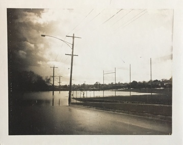
Photograph - Flooding of the Yarra Valley at Kew East, 1974
... Kew was devoted to dairy farming. In the twentieth century, before and after the construction of the Eastern Freeway, much of this low-lying area was used as golf courses and public parks....Kew was devoted to dairy farming. In the twentieth century, before and after the construction of the Eastern Freeway, much of this low-lying area was used as golf courses and public parks. ...Flooding of the Yarra Valley, including that section of the Yarra bordering Kew and Kew East in the north and west of the municipality, was a regular occurrence. Extreme flood events of the Yarra River are recorded to have occurred in 1891, 1901, 1916, 1923 and 1934. The Municipality of Kew's response to these floods was to enact planning decisions restricting residential development in flood prone areas following the floods of 1916, 1921 and 1934. While floods continued after the development of the Upper Yarra Reservoir (construction 1948-57), the regularity and extent of these inundations diminished. During the nineteenth century, the land abutting the south side of the Yarra in Kew was devoted to dairy farming. In the twentieth century, before and after the construction of the Eastern Freeway, much of this low-lying area was used as golf courses and public parks.Late example of the capacity of the Yarra Valley at Kew to flood, even though drainage works and the Upper Yarra Reservoir had reduced their regularity.Original black and white print photograph of the low-lying land at East Kew under floodwater on 16 May 1974. The vantage point of the photographer is at Willsmere Road. The road itself is underwater.Annotation verso: "Willsmere Rd / Same as No.7 / 16 May 1974 11.15am"floods, yarra river, willsmere road -
 Kew Historical Society Inc
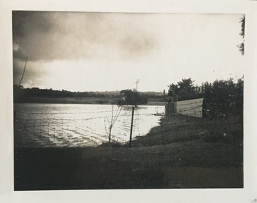
Photograph - Flooding of the Yarra Valley at Kew East, 1974
... Kew was devoted to dairy farming. In the twentieth century, before and after the construction of the Eastern Freeway, much of this low-lying area was used as golf courses and public parks....Kew was devoted to dairy farming. In the twentieth century, before and after the construction of the Eastern Freeway, much of this low-lying area was used as golf courses and public parks. ...Flooding of the Yarra Valley, including that section of the Yarra bordering Kew and Kew East in the north and west of the municipality, was a regular occurrence. Extreme flood events of the Yarra River are recorded to have occurred in 1891, 1901, 1916, 1923 and 1934. The Municipality of Kew's response to these floods was to enact planning decisions restricting residential development in flood prone areas following the floods of 1916, 1921 and 1934. While floods continued after the development of the Upper Yarra Reservoir (construction 1948-57), the regularity and extent of these inundations diminished. During the nineteenth century, the land abutting the south side of the Yarra in Kew was devoted to dairy farming. In the twentieth century, before and after the construction of the Eastern Freeway, much of this low-lying area was used as golf courses and public parks.Late example of the capacity of the Yarra Valley at Kew to flood, even though drainage works and the Upper Yarra Reservoir had reduced their regularity.Original black and white print photograph of the low-lying land at East Kew under floodwater on 16 May 1974. The photograph is of Hyde Park looking north-east.Annotation verso: "Hyde Park looking nth-east / Flood Level / 16 May 1974 11.15am / R.L. 46.61"floods, yarra river, hyde park -
 Kew Historical Society Inc
Photograph - Flooding of the Yarra Valley at Kew, 1974
... Kew was devoted to dairy farming. In the twentieth century, before and after the construction of the Eastern Freeway, much of this low-lying area was used as golf courses and public parks....Kew was devoted to dairy farming. In the twentieth century, before and after the construction of the Eastern Freeway, much of this low-lying area was used as golf courses and public parks. ...Flooding of the Yarra Valley, including that section of the Yarra bordering Kew and Kew East in the north and west of the municipality, was a regular occurrence. Extreme flood events of the Yarra River are recorded to have occurred in 1891, 1901, 1916, 1923 and 1934. The Municipality of Kew's response to these floods was to enact planning decisions restricting residential development in flood prone areas following the floods of 1916, 1921 and 1934. While floods continued after the development of the Upper Yarra Reservoir (construction 1948-57), the regularity and extent of these inundations diminished. During the nineteenth century, the land abutting the south side of the Yarra in Kew was devoted to dairy farming. In the twentieth century, before and after the construction of the Eastern Freeway, much of this low-lying area was used as golf courses and public parks.Late example of the capacity of the Yarra Valley at Kew to flood, even though drainage works and the Upper Yarra Reservoir had reduced their regularity.Original black and white print photograph of the low-lying land at East Kew under floodwater on 16 May 1974. The photograph is taken from 43 Kellett Grove.Annotation verso: "Kellett Gve No.43 / Flood Level / 16 May 1974 11.40am"floods, yarra river, kellett grove -
Kew Historical Society Inc
Archive (Sub-series) - Subject File, Latrobe Golf Club
... Kew and its environs, of which this file is an example. Typically files will contain primary and secondary sources. thomas wills lucern farm perce lay latrobe golf course Subject file containing information about the Latrobe Golf Club and course. ...Kew Historical SocietySince its foundation in 1958, members of the Kew Historical Society have been compiling and storing information about subjects relating to the history of Kew and its environs, of which this file is an example. Arranged by Secondary Values (value of records to users)Subject file containing information about the Latrobe Golf Club and course. The file contains a copy of a 1959 newspaper account of the building of the clubhouse on part of the former Lucern Farm which Thomas Wills established 120 years previously. The farm was later owned by Perce Lay, a Gallipoli veteran who progressively sold off parts until only 24 aces of the original 176 acres was left. The file also has a typescript of the back of Lucern Farm sale brochure for the auction on 14/4/1956. suggesting possible uses. Also gives an account of Thomas Wills' life and the improvements he made to the land. thomas wills, lucern farm, perce lay, latrobe golf coursethomas wills, lucern farm, perce lay, latrobe golf course