
Showing 53 items matching "kew mansions"
-
 Kew Historical Society Inc
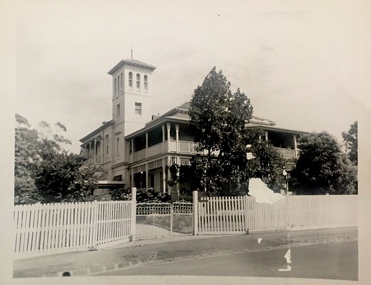
Photograph, J E & B L Rogers, 'Fernhurst', c.1959
... ...kew mansions...Together it forms the largest privately-donated collection within the archives of the Kew Historical Society. fernhurst -- kew (vic) historical houses -- kew (vic) kew mansions "Probably built in 1860s / Fernhurst" Small, black and white photo of Fernhurst in Kew, built for the architect and surveyor George Wharton. ...This work forms part of the collection assembled by the historian Dorothy Rogers, that was donated to the Kew Historical Society by her son John Rogers in 2015. The manuscripts, photographs, maps, and documents were sourced by her from both family and local collections or produced as references for her print publications. Many were directly used by Rogers in writing ‘Lovely Old Homes of Kew’ (1961) and 'A History of Kew' (1973), or the numerous articles on local history that she produced for suburban newspapers. Most of the photographs in the collection include detailed annotations in her hand.The Rogers Collection provides a comprehensive insight into the working habits of a historian in the 1960s and 1970s. Together it forms the largest privately-donated collection within the archives of the Kew Historical Society.Small, black and white photo of Fernhurst in Kew, built for the architect and surveyor George Wharton. (Now demolished)"Probably built in 1860s / Fernhurst"fernhurst -- kew (vic), historical houses -- kew (vic), kew mansions -
 Kew Historical Society Inc
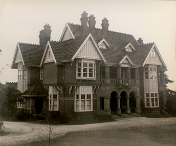
Photograph, 'Campion Hall', Studley Park Road, c.1960
... ...kew mansions...Together it forms the largest privately-donated collection within the archives of the Kew Historical Society. historic houses -- kew (vic.) campion hall -- house glendalough dalswraith-- dalsraith kew mansions "Ca. 1905 / Campion College / built for S.W. ...This work forms part of the collection assembled by the historian Dorothy Rogers, that was donated to the Kew Historical Society by her son John Rogers in 2015. The manuscripts, photographs, maps, and documents were sourced by her from both family and local collections or produced as references for her print publications. Many were directly used by Rogers in writing ‘Lovely Old Homes of Kew’ (1961) and 'A History of Kew' (1973), or the numerous articles on local history that she produced for suburban newspapers. Most of the photographs in the collection include detailed annotations in her hand.The Rogers Collection provides a comprehensive insight into the working habits of a historian in the 1960s and 1970s. Together it forms the largest privately-donated collection within the archives of the Kew Historical Society.Small black and white photograph of 'Campion Hall' (previously called Dalswraith and Glendalough) in Studley Park Road, Kew."Ca. 1905 / Campion College / built for S.W. Gibson"historic houses -- kew (vic.), campion hall -- house, glendalough, dalswraith-- dalsraith, kew mansions -
 Kew Historical Society Inc
Archive (Sub-series) - Lyons, Dorothy File, Kew Historical Society, 'Ivy Grange', 1-3 Malmsbury Street, 1970
... ivy grange - 1-3 malmsbury street - kew (vic)...mansions...Typically files will contain primary and secondary sources. kew historical society - archives kew - history ivy grange - 1-3 malmsbury street - kew (vic) mansions - kew (vic) david beath (1835-1922) architects - victoria - charles vickers Archive file containing brief notes on the history of the Ivy Grange compiled from various sources plus correspondence and planning documents relating to plans submitted to the City of Kew to alter the portico facing Malmsbury Street, Kew. ...Various partiesReference, Research, InformationSecondary Values (KHS Imposed Order)Subject file containing brief notes on the history of the Ivy Grange compiled from various sources plus correspondence and planning documents relating to plans submitted to the City of Kew to alter the portico facing Malmsbury Street, Kew. These plans predated the first Kew Urban Conservation Study (Sanderson, 1988). There is also one newspaper article relating to the sale of the house in 2005.kew historical society - archives, kew - history, ivy grange - 1-3 malmsbury street - kew (vic), mansions - kew (vic), david beath (1835-1922), architects - victoria - charles vickerskew historical society - archives, kew - history, ivy grange - 1-3 malmsbury street - kew (vic), mansions - kew (vic), david beath (1835-1922), architects - victoria - charles vickers -
 Kew Historical Society Inc
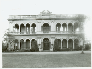
Photograph - 'Ross House' (formerly 'Charleville'), 292 Cotham Road, Progress Press, 1978
... houses --- Cotham Road -- kew (Vic.)...mansions...Dr Tom King, surgeon purchased Charleville from Donaldson in 1939 and renamed it Ross House. ross house charleville houses --- Cotham Road -- kew (Vic.) mansions -- kew (Vic.) Photographic print positive of 'Ross House' (formerly 'Charleville'), Cotham Road Photograph 'Ross House' (formerly 'Charleville'), 292 Cotham Road Progress Press ...Ross House, formerly called Charleville, was built as a two-storey mansion in 1889 for Charles Donaldson. It was designed in the Italianate style by the architect H. Shallers and built by G. Ginham. Dr Tom King, surgeon purchased Charleville from Donaldson in 1939 and renamed it Ross House.Photographic print positive of 'Ross House' (formerly 'Charleville'), Cotham Roadross house, charleville, houses --- cotham road -- kew (vic.), mansions -- kew (vic.) -
 Kew Historical Society Inc
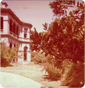
Photograph - 'Mandalay', Molesworth Street (Kew), 1979
... historic houses -- kew (vic.)...mansions...mandalay historic houses -- kew (vic.) mansions -- kew (vic.) morrissey family Annotated in ink on reverse: " Mandalay, 3 Molesworth St. / once Morrissey family home / Donated by E Mackie 1979" Small, square, original colour positive photograph of 'Mandalay', Molesworth Street, Kew, taken in 1979 by Elizabeth Mackie. ...Small, square, original colour positive photograph of 'Mandalay', Molesworth Street, Kew, taken in 1979 by Elizabeth Mackie. Side view showing double-storey colonnade faced with cement pilasters on first floor and projecting bay window on both floors.Annotated in ink on reverse: " Mandalay, 3 Molesworth St. / once Morrissey family home / Donated by E Mackie 1979"mandalay, historic houses -- kew (vic.), mansions -- kew (vic.), morrissey family -
 Kew Historical Society Inc
Photograph - 1 Molesworth Street (Kew), 1979
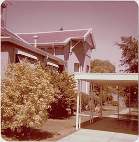
... historic houses -- kew (vic.)...mansions...The Melbourne Mansion Database confirms that the house was built by Lloyd Taylor & Fitts in c.1898. historic houses -- kew (vic.) mansions -- kew (vic.) architects -- lloyd tayler 1 molesworth st -- kew (vic.) ...No 1 Molesworth Street was at one stage the home of our member Elizabeth Mackie. She believed the house, like Mynda at 5 Molesworth Street was designed by the architect Lloyd Tayler. The Melbourne Mansion Database confirms that the house was built by Lloyd Taylor & Fitts in c.1898.Small, square, original colour positive photograph of 1 Molesworth Street, Kew, taken in 1979 by Elizabeth Mackie. Carport and driveway with grey rendered two storey house at left. Annotated in ink on reverse: " No.1 Molesworth St. / Architect - Lloyd Tayler 1880s [sic] / Gift of E Mackie"historic houses -- kew (vic.), mansions -- kew (vic.), architects -- lloyd tayler, 1 molesworth st -- kew (vic.) -
 Kew Historical Society Inc
Accessory, Beaded Black Silk Evening Purse, 1900s
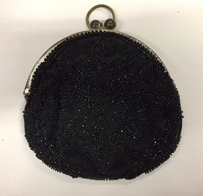
... Frequently used when formal dinner dances were held in the Kew mansions." [Editor - See correct date in Physical description]...Frequently used when formal dinner dances were held in the Kew mansions." [Editor - See correct date in Physical description] Hand-beaded evening purse, with silver frame and finger ring. ...The Kew Historical Society's Fashion & Design collection includes a small and representative collection of reticules, purses and handbags, purchased, inherited or collected by members of the Society. These items date from the Nineteenth and Twentieth centuries, and conform to fashions and styles popular during the period of their use. Some of the items are handmade, while others are mass-produced commercial products. Hand-beaded evening purse, with silver frame and finger ring. While the note accompanying the item states that it was made and used in the 1880s, the label 'Made in France' would indicate that it was probably made in the first decade of the twentieth century.Label: "Made in France / Hand-made". A note which accompanies the item states: "Hand beaded evening purse, 1880s. Frequently used when formal dinner dances were held in the Kew mansions." [Editor - See correct date in Physical description]fashion accessories, clothing accessories, women's clothing -- accessories, bags -- handbags, bags -- purses -
 Kew Historical Society Inc
Photograph - Gates of 'Raheen', Studley Park Road, 1981
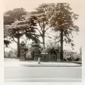
... raheen -- studley park road -- kew (vic.)...mansions...(Source: VHD) raheen -- studley park road -- kew (vic.) mansions -- studley park -- kew (vic.) historic houses -- studley park -- kew (vic.) raheen Verso: "Gates to Raheen 1981" Photographic positive showing the gates to the mansion 'Raheen' in Studley Park Road. ...The first section of Raheen was commenced in 1870 with an extension added in 1884. It was designed by William Salway and built for Edward Latham of the Carlton Brewery. Sir Henry Wrixon, prominent Melbourne barrister and solicitor, later owned and resided at the property. In 1917 Raheen was purchased by the Catholic Church and became the official residence of Archbishop Mannix, as well as four other Catholic archbishops of Melbourne. In 1981 the Church sold the property and it again reverted to a private residence. (Source: VHD)Photographic positive showing the gates to the mansion 'Raheen' in Studley Park Road. Notable are the three Himalayan Cedars inside and outside the high brick fence.Verso: "Gates to Raheen 1981"raheen -- studley park road -- kew (vic.), mansions -- studley park -- kew (vic.), historic houses -- studley park -- kew (vic.), raheen -
 Kew Historical Society Inc
Photograph, 'Goathland', The Residence of Sir Malcolm D McEacharn, 1901-1911
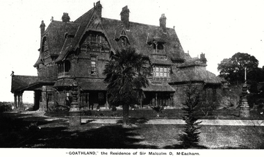
... kew (vic.)...melbourne mansions...The house was demolished in 1960, despite opposition from the National Trust (Victoria), and its gardens subdivided into residential allotments. byram goathland tara hall lowan studley park road -- kew (vic.) melbourne mansions e g kilburn - architect "'Goathland', The Residence of Sir Malcolm D McEacharn" An early photograph of Goathland (also known as Byram, Lowan and Tara Hall). ...The architect, Edward Kilburn designed Byram in the Arts & Crafts style for the industrialist George Ramsden. Construction began in 1888 and was reputed to have lasted three years. The mansion had frontages to Studley Park Road and Stevenson Street, including gardens laid out with great taste, including pleasure grounds, tennis lawn, fruit and flower garden, and paddock.The size of many of the trees in the garden indicate that many survived from the garden of Clifton Villa, the previous single-storeyed house built on the site by the Stevenson brothers. Byram had views to Melbourne and Port Phillip Bay. The house was demolished in 1960, despite opposition from the National Trust (Victoria), and its gardens subdivided into residential allotments.An early photograph of Goathland (also known as Byram, Lowan and Tara Hall). The photo shows the front of the building during the period of Sir Malcolm McEacharn’s occupation of the house (1901-11). Edward George Kilburn, of Ellerker & Kilburn, had originally designed the house for the industrialist George Ramsden in 1888. When Sir Malcolm McEacharn purchased Byram, he was to rename it as Goathland. This has led to some confusion, as Goathland was also the name used for McEacharn’s other home in St. Kilda. The period of McEacharn’s ownership represented the high point of the mansion’s history. 'Lost Glories: a memorial to forgotten Australian buildings' was published by David Latta in 1986. It tells the story of a number of significant Australian buildings that had previously been demolished. A chapter in the book was devoted to Goathland, later known as Tara Hall. To supplement the text, he sourced photographs from a range of suppliers, chiefly the Royal Women's Hospital which had once owned Tara Hall, but had sold it in 1960. This is one of the photographs donated to KHS by the author."'Goathland', The Residence of Sir Malcolm D McEacharn"byram, goathland, tara hall, lowan, studley park road -- kew (vic.), melbourne mansions, e g kilburn - architect -
 Kew Historical Society Inc
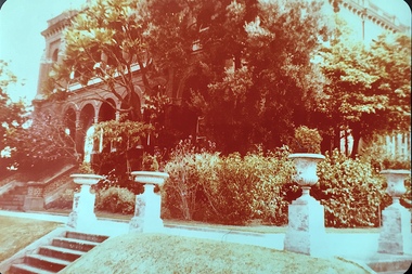
Photograph - 'Raheen', 96 Studley Park Road
... kew (vic.)...historic houses -- studley park...mansions...(source VHD) raheen -- 96 studley park road -- kew (vic.) historic houses -- studley park mansions -- kew (vic.) ...Raheen was constructed as a two-storey house in the Italianate style with a four-storey tower over the entrance and single-storey extension. It was designed in an asymmetric and arcaded form, and is built of red brick with cement render. The property retains its garden layout, including an Italianate garden, outbuildings, fence and gates, and internal features including the original stairwell, library, ballroom and cast iron tower stairs. (source VHD)View of the upper and lower eastern loggias of 'Raheen' at 96 Studley Park Road, Kew from the eastern garden. The colour photo shows the pedestals and urns above the steps and the plantings in the garden c.1980. raheen -- 96 studley park road -- kew (vic.), historic houses -- studley park, mansions -- kew (vic.) -
 Kew Historical Society Inc
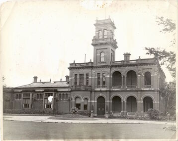
Photograph - 'Raheen', Studley Park Road (Kew), c.1965
... ...mansions -- kew (Vic.)...Kew' (1973), or the numerous articles on local history that she produced for suburban newspapers. Most of the photographs in the collection include detailed annotations in her hand. The Rogers Collection provides a comprehensive insight into the working habits of a historian from the 1960s to the 1970s. reheen mansions -- kew (Vic.) ..."The first section of Raheen was commenced in 1870 with an extension added in 1884. It was designed by William Salway and built for Edward Latham of the Carlton Brewery. Sir Henry Wrixon, prominent Melbourne barrister and solicitor, later owned and resided at the property. In 1917 Raheen was purchased by the Catholic Church and became the official residence of Archbishop Mannix, as well as four other Catholic archbishops of Melbourne. In 1981 the Church sold the property and it again reverted to a private residence." (Victorian Heritage Database, 2023)This work forms part of the collection assembled by the historian Dorothy Rogers (1905-1973), donated to the Kew Historical Society by her son in 2015. The manuscripts, photographs, maps, and documents were sourced by her from both family and local collections or produced as references for her print publications. Many were directly used by Rogers in writing ‘Lovely Old Homes of Kew’ (1961) and 'A History of Kew' (1973), or the numerous articles on local history that she produced for suburban newspapers. Most of the photographs in the collection include detailed annotations in her hand. The Rogers Collection provides a comprehensive insight into the working habits of a historian from the 1960s to the 1970s. Original, monochrome print copy of a photograph of Raheen in Studley Park Road (Kew). The unrendered red brick house with tower has a toe story section at right with a double colonnade and a single story section at left. The photographs predates the restoration of the gardens and house by te. Pratt family. Annotation verso: "Raheen. R. C. Archbishops Palace, Studley Park Road, Kew".reheen, mansions -- kew (vic.), studley park road -
 Kew Historical Society Inc
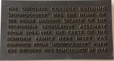
Plaque - Commemorative Plaque, Institute of Early Childhood Development, 'Mooroolbeek', Madden Grove, Kew, c.1968
... Bronze plaque commemorating the location of Mooroolbeek, one of the great mansions of Kew, demolished in 1968 by the Kindergarten Training College...Commemorative plaque indicating the location of a former Kew mansion institute of early childhood development - kew (vic) mooroolbeek - madden grove - kew (vic) sir frank madden "The original college building "Mooroolbeek" was the home of Sir Frank Madden Speaker of the Victorian Legislative Assembly from 1904-1917. The crest of the Madden family here inset was removed from "Mooroolbeek" when the building was demolished in 1968." Bronze plaque commemorating the location of Mooroolbeek, one of the great mansions ...The Free Kindergarten Union of Victoria commenced teacher training in 1909. A two year course was run in cooperation with the Education Department in 1910-14, but from 1917 the Union trained its students independently. In 1922 the Kindergarten Training College was established in Mooroolbeek, Kew. In 1965, the institution, as the Melbourne Kindergarten Teachers' College, became an entity separate from the Union, and in 1973 joined the State College of Victoria as the Institute of Early Childhood Development. It subsequently amalgamated with the University of Melbourne to become the Department of Early Childhood Studies and moved from Madden Grove, Kew, to 234 Queensberry St, Carlton, early in July 1997.Commemorative plaque indicating the location of a former Kew mansionBronze plaque commemorating the location of Mooroolbeek, one of the great mansions of Kew, demolished in 1968 by the Kindergarten Training College"The original college building "Mooroolbeek" was the home of Sir Frank Madden Speaker of the Victorian Legislative Assembly from 1904-1917. The crest of the Madden family here inset was removed from "Mooroolbeek" when the building was demolished in 1968."institute of early childhood development - kew (vic), mooroolbeek - madden grove - kew (vic), sir frank madden -
 Kew Historical Society Inc
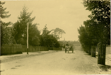
Photograph, J F C Farquhar, Studley Park Road, 1891
... The view emphasises the exclusiveness of Studley Park, with its high fences behind which a number of significant Kew mansions were concealed. Contemporary advertisements for the sale of mansions in Studley Park Road often included fulsome descriptions of their elaborate formal gardens, as well as paddocks for grazing, stabling and dairies. ...The view emphasises the exclusiveness of Studley Park, with its high fences behind which a number of significant Kew mansions were concealed. Contemporary advertisements for the sale of mansions in Studley Park Road often included fulsome descriptions of their elaborate formal gardens, as well as paddocks for grazing, stabling and dairies. ...At the beginning of the 1890s, the Kew businessman and Town Councillor, Henry Kellett, commissioned J.F.C. Farquhar to photograph scenes of Kew. These scenes included panoramas as well as pastoral scenes. The resulting set of twelve photographs was assembled in an album, Kew Where We Live, from which customers could select images for purchase.The preamble to the album describes that the photographs used the ‘argentic bromide’ process, now more commonly known as the gelatine silver process. This form of dry plate photography allowed for the negatives to be kept for weeks before processing, hence its value in landscape photography. The resulting images were considered to be finely grained and everlasting. Evidence of the success of Henry Kellett’s venture can be seen today, in that some of the photographs are held in national collections.It is believed that the Kew Historical Society’s copy of the Kellett album is unique and that the photographs in the book were the first copies taken from the original plates. It is the first and most important series of images produced about Kew. The individual images have proved essential in identifying buildings and places of heritage value in the district.In this view of Studley Park Road, looking northeast to the Junction, the photographer invites the viewer to participate in a point-of-view that emphasises the elevated, tranquil vantage point of the hill in contrast to the bustling commercial area in the distance. The view emphasises the exclusiveness of Studley Park, with its high fences behind which a number of significant Kew mansions were concealed. Contemporary advertisements for the sale of mansions in Studley Park Road often included fulsome descriptions of their elaborate formal gardens, as well as paddocks for grazing, stabling and dairies. None can be seen here. The use of high, protective wooden pickets to surround the newly planted avenue of elms on the south side of the road appears to be typical of the period. Similar examples can be seen in early photographs of Wellington and Princess Streets.The horse and carriage, selected as a central focus of the view, reinforces the residential, exclusive nature of this part of Kew in the early 1890s. Studley Park Roadkew illustrated, kew where we live, photographic books, henry kellett -
 Kew Historical Society Inc
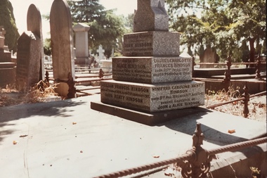
Photograph - Hindson family grave, Boroondara General Cemetery
... A number of significant mansions in Kew were owned at various stages by members of the immediate family and or their descendants. ...A number of significant mansions in Kew were owned at various stages by members of the immediate family and or their descendants. ...The sons and daughters of Thomas and Frances Henty were notable settlers, initially in Western Australia, then in Launceston and finally in Victoria. A number of significant mansions in Kew were owned at various stages by members of the immediate family and or their descendants. The Boroondara General Cemetery includes a number of memorials of or to Henty family members.Original colour positive photograph of a Hindson family grave in the Boroondara General Cemetery. This is one of a number of photographs taken c.1987 of graves/headstones of descendants of the Henty family of Victoria. This particular grave is located in Section C/E C 1117A and holds the remains of John Hindson, Alice Hindson, William Francis Hindson. [Alice Hindson was the daughter of Francis Henty]. Other members of the Hindson family are recorded on the grave but are not listed as buried at the site in the Boroondara General Cemetery records of burials. henty family, boroondara general cemetery, john hindson, alice hindson, william francis hindson -
 Kew Historical Society Inc
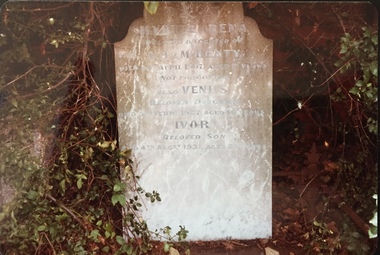
Photograph - Henty family grave, Boroondara General Cemetery
... A number of significant mansions in Kew were owned at various stages by members of the immediate family and or their descendants. ...A number of significant mansions in Kew were owned at various stages by members of the immediate family and or their descendants. ...The sons and daughters of Thomas and Frances Henty were notable settlers, initially in Western Australia, then in Launceston and finally in Victoria. A number of significant mansions in Kew were owned at various stages by members of the immediate family and or their descendants. The Boroondara General Cemetery includes a number of memorials of or to Henty family members.Original colour positive photograph of a Henty family grave in the Boroondara General Cemetery. This is one of a number of photographs taken c.1987 of graves/headstones of descendants of the Henty family of Victoria. This particular grave is located in Section PRES A 1227 and holds the remains of Myrtle Irena Henty, Venus Walker Henty, Ivor Arthur Henty, the children of Mr & Mrs AJ Henty.. henty family, boroondara general cemetery, myrtle irena henty, venus walker henty, ivor arthur henty -
 Kew Historical Society Inc
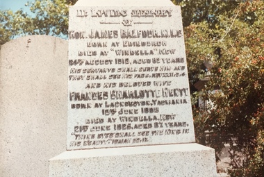
Photograph - Balfour family grave, Boroondara General Cemetery
... A number of significant mansions in Kew were owned at various stages by members of the immediate family and or their descendants. ...A number of significant mansions in Kew were owned at various stages by members of the immediate family and or their descendants. ...The sons and daughters of Thomas and Frances Henty were notable settlers, initially in Western Australia, then in Launceston and finally in Victoria. A number of significant mansions in Kew were owned at various stages by members of the immediate family and or their descendants. The Boroondara General Cemetery includes a number of memorials of or to Henty family members.Original colour positive photograph of a Balfour family grave in the Boroondara General Cemetery. This is one of a number of photographs taken c.1987 of graves/headstones of descendants of the Henty family of Victoria. This particular grave is located in Section PRES A 0058 and holds the remains of James Balfour and his wife Frances Charlotte Henty. James Balfour was a Scottish-born Australian merchant and politician, member of the Victorian Legislative Assembly 1866 to 1868 and of the Victorian Legislative Council from 1874 to 1913. In 1859, he married Frances Charlotte, eldest daughter of Hon. James Henty, M.L.C. They had 11 children, nine of whom survived him.henty family, boroondara general cemetery, james balfour, frances charlotte henty -
 Kew Historical Society Inc
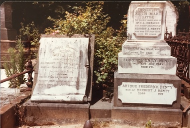
Photograph - Henty family graves, Boroondara General Cemetery
... A number of significant mansions in Kew were owned at various stages by members of the immediate family and or their descendants. ...A number of significant mansions in Kew were owned at various stages by members of the immediate family and or their descendants. ...The sons and daughters of Thomas and Frances Henty were notable settlers, initially in Western Australia, then in Launceston and finally in Victoria. A number of significant mansions in Kew were owned at various stages by members of the immediate family and or their descendants. The Boroondara General Cemetery includes a number of memorials of or to Henty family members.Original colour positive photograph of two Henty family graves in the Boroondara General Cemetery. This is one of a number of photographs taken c.1987 of graves/headstones of descendants of the Henty family of Victoria. The scrolled headstone at left is located at Section C/E D 0241 and its grave contains the remains of Herbert William (Willy) Henty, Frances Emma Henty, May Lillian Henty. The headstone at right is located in Section C/E D 0245 and its grave holds the remains of Edith Mary (Lettie) Embling (nee Henty), Florence Emily Henty, Arthur Frederick Henty, 'Stillborn Skamp'. henty family, boroondara general cemetery, herbert william (willy) henty, frances emma henty, may lillian henty, edith mary (lettie) embling (nee henty), florence emily henty, arthur frederick henty, 'stillborn skamp' -
 Kew Historical Society Inc
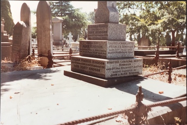
Photograph - Hindson family grave, Boroondara General Cemetery
... A number of significant mansions in Kew were owned at various stages by members of the immediate family and or their descendants. ...A number of significant mansions in Kew were owned at various stages by members of the immediate family and or their descendants. ...The sons and daughters of Thomas and Frances Henty were notable settlers, initially in Western Australia, then in Launceston and finally in Victoria. A number of significant mansions in Kew were owned at various stages by members of the immediate family and or their descendants. The Boroondara General Cemetery includes a number of memorials of or to Henty family members.Original colour positive photograph of a Hindson family grave in the Boroondara General Cemetery. This is one of a number of photographs taken c.1987 of graves/headstones of descendants of the Henty family of Victoria. This particular grave is located in Section C/E C 1117A and holds the remains of John Hindson, Alice Hindson, William Francis Hindson. [Alice Hindson was the daughter of Francis Henty]. Other members of the Hindson family are recorded on the grave but are not listed as buried at the site in the Boroondara General Cemetery records of burials. henty family, boroondara general cemetery, john hindson, alice hindson, william francis hindson -
 Kew Historical Society Inc
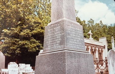
Photograph - Henty family graves, Boroondara General Cemetery
... A number of significant mansions in Kew were owned at various stages by members of the immediate family and or their descendants. ...A number of significant mansions in Kew were owned at various stages by members of the immediate family and or their descendants. ...The sons and daughters of Thomas and Frances Henty were notable settlers, initially in Western Australia, then in Launceston and finally in Victoria. A number of significant mansions in Kew were owned at various stages by members of the immediate family and or their descendants. The Boroondara General Cemetery includes a number of memorials of or to Henty family members.Original colour positive photograph of Edward Henty's obelisk in the Boroondara General Cemetery. This is one of a number of photographs taken c.1987 of graves/headstones of descendants of the Henty family of Victoria. The obelisk is located at Section C/E D 0201 and its grave contains the remains of Edward Henty, Anna Maria Henty. henty family, boroondara general cemetery, edward henty, anna maria henty -
 Kew Historical Society Inc
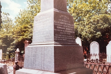
Photograph - Henty family graves, Boroondara General Cemetery
... A number of significant mansions in Kew were owned at various stages by members of the immediate family and or their descendants. ...A number of significant mansions in Kew were owned at various stages by members of the immediate family and or their descendants. ...The sons and daughters of Thomas and Frances Henty were notable settlers, initially in Western Australia, then in Launceston and finally in Victoria. A number of significant mansions in Kew were owned at various stages by members of the immediate family and or their descendants. The Boroondara General Cemetery includes a number of memorials of or to Henty family members.Original colour positive photograph of Edward Henty's obelisk in the Boroondara General Cemetery. This is one of a number of photographs taken c.1987 of graves/headstones of descendants of the Henty family of Victoria. The obelisk is located at Section C/E D 0201 and its grave contains the remains of Edward Henty, Anna Maria Henty. henty family, boroondara general cemetery, edward henty, anna maria henty -
 Kew Historical Society Inc
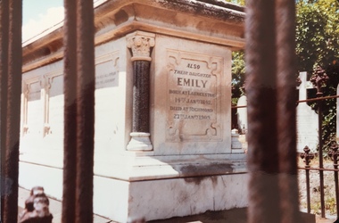
Photograph - Henty family graves, Boroondara General Cemetery
... A number of significant mansions in Kew were owned at various stages by members of the immediate family and or their descendants. ...A number of significant mansions in Kew were owned at various stages by members of the immediate family and or their descendants. ...The sons and daughters of Thomas and Frances Henty were notable settlers, initially in Western Australia, then in Launceston and finally in Victoria. A number of significant mansions in Kew were owned at various stages by members of the immediate family and or their descendants. The Boroondara General Cemetery includes a number of memorials of or to Henty family members.Original colour positive photograph of Edward Henty's obelisk in the Boroondara General Cemetery. This is one of a number of photographs taken c.1987 of graves/headstones of descendants of the Henty family of Victoria. henty family, boroondara general cemetery, edward henty, anna maria henty -
 Kew Historical Society Inc
Plan, Melbourne & Metropolitan Board of Works : Borough of Kew : Detail Plan No.1585, 1904
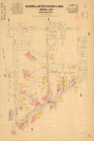
... This plan, which covers parts of High Street, Pakington Street and Derby Street is dominated by two historic Kew mansions: ‘Konetta’ and ‘Ramornie’. Ramornie was constructed in 1890 for James Maitland Campbell, three times Mayor of Kew. ...This plan, which covers parts of High Street, Pakington Street and Derby Street is dominated by two historic Kew mansions: ‘Konetta’ and ‘Ramornie’. Ramornie was constructed in 1890 for James Maitland Campbell, three times Mayor of Kew. ...The Melbourne and Metropolitan Board of Works (MMBW) plans were produced from the 1890s to the 1950s. They were crucial to the design and development of Melbourne's sewerage and drainage system. The plans, at a scale of 40 feet to 1 inch (1:480), provide a detailed historical record of Melbourne streetscapes and environmental features. Each plan covers one or two street blocks (roughly six streets), showing details of buildings, including garden layouts and ownership boundaries, and features such as laneways, drains, bridges, parks, municipal boundaries and other prominent landmarks as they existed at the time each plan was produced. (Source: State Library of Victoria)This plan forms part of a large group of MMBW plans and maps that was donated to the Society by the Mr Poulter, City Engineer of the City of Kew in 1989. Within this collection, thirty-five hand-coloured plans, backed with linen, are of statewide significance as they include annotations that provide details of construction materials used in buildings in the first decade of the 20th century as well as additional information about land ownership and usage. The copies in the Public Record Office Victoria and the State Library of Victoria are monochrome versions which do not denote building materials so that the maps in this collection are invaluable and unique tools for researchers and heritage consultants. A number of the plans are not held in the collection of the State Library of Victoria so they have the additional attribute of rarity.Original survey plan, issued by the MMBW to a contractor with responsibility for constructing sewers in the area identified on the plan within the Borough of Kew. The plan was at some stage hand-coloured, possibly by the contractor, but more likely by officers working in the Engineering Department of the Borough and later Town, then City of Kew. The hand-coloured sections of buildings on the plan were used to denote masonry or brick constructions (pink), weatherboard constructions (yellow), and public buildings (grey). This plan, which covers parts of High Street, Pakington Street and Derby Street is dominated by two historic Kew mansions: ‘Konetta’ and ‘Ramornie’. Ramornie was constructed in 1890 for James Maitland Campbell, three times Mayor of Kew. Sold in 1940, it became a boarding house known as ‘The Towers’. Now a private residence again, it has only one of its three balconies remaining. The location of the missing two balconies can be seen on the plan. In 1903, the grounds of Ramornie included a large tennis court fronting Pakington Street. The rear of the property is shown as extending to Cobden Street. One of Kew’s oldest hotels, the Prospect Hill Hotel on the corner of High and Cobden Street was established in 1858. The outline of the hotel shown on the plan represents the second building on the site. During the 19th century it was often used for electoral meetings. The Prospect Hill Hotel was to be redeveloped again in 1928, by the local architect Robert McIntyre. Since the 1980s, the hotel has been a live music venue, the home of the Melbourne Jazz Club, a restaurant and a liquor outlet.melbourne and metropolitan board of works, detail plans, maps - borough of kew, mmbw 1585, cartography -
 Mission to Seafarers Victoria
Article, Kerrie O'Brien, Want to peek inside Melbourne’s finest mansions and buildings? This is your chance, 30 June 2022
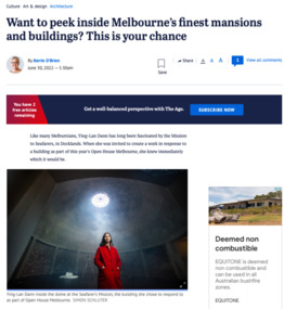
... Swinging open their doors at the end of the month will be some of the city’s finest mansions, including Villa Alba in Kew and Brighton’s Billilla, the Cairo flats in Fitzroy, the newly renovated Jewish Museum designed by Kerstin Thompson, the Melbourne Quakers Centre, the Albanian Mosque in Carlton North and many more. ...Swinging open their doors at the end of the month will be some of the city’s finest mansions, including Villa Alba in Kew and Brighton’s Billilla, the Cairo flats in Fitzroy, the newly renovated Jewish Museum designed by Kerstin Thompson, the Melbourne Quakers Centre, the Albanian Mosque in Carlton North and many more. ...Open House 2022: "Like many Melburnians, Ying-Lan Dann has long been fascinated by the Mission to Seafarers, in Docklands. When she was invited to create a work in response to a building as part of this year’s Open House Melbourne, she knew immediately which it would be. Taking a peek behind the closed doors of some of Melbourne’s finest and most interesting buildings is a core premise of the weekend event, now in its 15th year. During that time, the program has grown from half a dozen buildings to a 200-plus strong list that extends to Ballarat and Bendigo. “[It’s] much more expansive and citizen-led,” says Fleur Watson, Open House Melbourne’s executive director. “As a public festival, it has always had a spirit of generosity, this gesture of opening up and allowing visitors to come and look and experience things.” Swinging open their doors at the end of the month will be some of the city’s finest mansions, including Villa Alba in Kew and Brighton’s Billilla, the Cairo flats in Fitzroy, the newly renovated Jewish Museum designed by Kerstin Thompson, the Melbourne Quakers Centre, the Albanian Mosque in Carlton North and many more. Considering how to approach the event this year, held remotely for the past two, Watson decided to explore beyond the traditional, with associate professor and director of curatorial practice at Monash University Tara McDowell. The two have co-curated an exhibition of works to run concurrently with the Open House program, called Take Hold of the Clouds. That’s where Dann’s work, Circular Temporalities, comes in, one of seven commissions around town in which local and international artists respond to chosen buildings or sites. A lecturer in interior design at RMIT as well as an artist, she is interested in time and finding different mediums to show things in flux and, having grown up on Phillip Island, she often uses water as a theme. When she started spending time at the Mission, Dann found there was an oculus at the top of the dome, known as the Norla Dome. She thought about how that small but significant opening related to where sailors spent so many months of the year, the sky being the only thing they would see much of the time, stars guiding the way in times gone by, and of the recent stories she’d heard about sailors being trapped at sea during COVID. Built in the Arts and Craft style between 1916 and 1919 and designed by architect Walter Butler, the Mission includes a chapel, clubroom, Chaplain’s house, a small cottage and the Norla Dome, which was apparently inspired by the Pantheon. The Mission was funded by the government and the Ladies Harbour Lights Guild, who Dann was also intrigued by. “One of the things those women identified is that life at sea is very dangerous [and they] wanted to give them a space of sanctuary and support,” she says, adding that for many years, the dome was used as a gymnasium. Her work inside the dome includes a 35-minute loop film, recorded from the ferry during the crossing from Queenscliff to Sorrento. The horizon takes up about a third of the shot and moves as the waves rise and fall, mirroring the journeys made by the sailors who found refuge at the mission over the years; it will be projected onto a gauze-like fabric, allowing glimpses of the building behind. Dann also plans to activate the site over the course of the weekend and will read a poem by Justin Clemens.The articles gives an insight of the création of the artwork by Ying-Lan Dann. digital copy of an article with photographs published in the Ageopen house melbourne, 2022, ying-lan dann, take hold of the clouds, norla dome, exhibition, the age, cultural events -
 Kew Historical Society Inc
Plan, Melbourne & Metropolitan Board of Works : Borough of Kew : Detail Plan No.1291, 1905
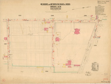
... Kew. The hand-coloured sections of buildings on the plan were used to denote masonry or brick constructions (pink), weatherboard constructions (yellow), and public buildings (grey). A detail plan of part of Studley Park bordered by the major streets of Hodgson Street, Stevenson Street and Studley Park Road. Included on the plan are a number of significant Studley Park mansions...Kew. The hand-coloured sections of buildings on the plan were used to denote masonry or brick constructions (pink), weatherboard constructions (yellow), and public buildings (grey). A detail plan of part of Studley Park bordered by the major streets of Hodgson Street, Stevenson Street and Studley Park Road. Included on the plan are a number of significant Studley Park mansions ...The Melbourne and Metropolitan Board of Works (MMBW) plans were produced from the 1890s to the 1950s. They were crucial to the design and development of Melbourne's sewerage and drainage system. The plans, at a scale of 40 feet to 1 inch (1:480), provide a detailed historical record of Melbourne streetscapes and environmental features. Each plan covers one or two street blocks (roughly six streets), showing details of buildings, including garden layouts and ownership boundaries, and features such as laneways, drains, bridges, parks, municipal boundaries and other prominent landmarks as they existed at the time each plan was produced. (Source: State Library of Victoria). This plan forms part of a large group of MMBW plans and maps that was donated to the Society by the Mr Poulter, City Engineer of the City of Kew in 1989. Within this collection, thirty-five hand-coloured plans, backed with linen, are of statewide significance as they include annotations that provide details of construction materials used in buildings in the first decade of the 20th century as well as additional information about land ownership and usage. The copies in the Public Record Office Victoria and the State Library of Victoria are monochrome versions which do not denote building materials so that the maps in this collection are invaluable and unique tools for researchers and heritage consultants. A number of the plans are not held in the collection of the State Library of Victoria so they have the additional attribute of rarity.Original survey plan, issued by the MMBW to a contractor with responsibility for constructing sewers in the area identified on the plan within the Borough of Kew. The plan was at some stage hand-coloured, possibly by the contractor, but more likely by officers working in the Engineering Department of the Borough and later Town, then City of Kew. The hand-coloured sections of buildings on the plan were used to denote masonry or brick constructions (pink), weatherboard constructions (yellow), and public buildings (grey). A detail plan of part of Studley Park bordered by the major streets of Hodgson Street, Stevenson Street and Studley Park Road. Included on the plan are a number of significant Studley Park mansions in existence at the beginning of the 20th century. The unnamed street shown in the middle of the plan is McEvoy Street. The most important house still extant is Campion House, formerly named Dalsraith [Dalswraith] and Glendalough, owned since the 1940s by the Society of Jesus. Campion House can be seen on the corner of Hodgson and Studley Park Road. Its stables at the rear of the block have now been incorporated into a contemporary residence. An interesting feature of the plan is the 1910 annotation by Ed Seitz, professional designing engineer. Is Seitz the contractor who modified the MMBW original?melbourne and metropolitan board of works, detail plans, mmbw 1291, cartography -
 Kew Historical Society Inc
Plan, Melbourne and Metropolitan Board of Works, Melbourne & Metropolitan Board of Works : Borough of Kew : Detail Plan No.1294 & 1295, 1904
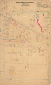
... Kew. MMBW plans were amended over time to take account of new subdivisions such as that which created Merrion Place. Of the four mansions...Kew. MMBW plans were amended over time to take account of new subdivisions such as that which created Merrion Place. Of the four mansions ...The Melbourne and Metropolitan Board of Works (MMBW) plans were produced from the 1890s to the 1950s. They were crucial to the design and development of Melbourne's sewerage and drainage system. The plans, at a scale of 40 feet to 1 inch (1:480), provide a detailed historical record of Melbourne streetscapes and environmental features. Each plan covers one or two street blocks (roughly six streets), showing details of buildings, including garden layouts and ownership boundaries, and features such as laneways, drains, bridges, parks, municipal boundaries and other prominent landmarks as they existed at the time each plan was produced. (Source: State Library of Victoria). This plan forms part of a large group of MMBW plans and maps that was donated to the Society by the Mr Poulter, City Engineer of the City of Kew in 1989. Within this collection, thirty-five hand-coloured plans, backed with linen, are of statewide significance as they include annotations that provide details of construction materials used in buildings in the first decade of the 20th century as well as additional information about land ownership and usage. The copies in the Public Record Office Victoria and the State Library of Victoria are monochrome versions which do not denote building materials so that the maps in this collection are invaluable and unique tools for researchers and heritage consultants. A number of the plans are not held in the collection of the State Library of Victoria so they have the additional attribute of rarity.Original survey plan, issued by the MMBW to a contractor with responsibility for constructing sewers in the area identified on the plan within the Borough of Kew. The plan was at some stage hand-coloured, possibly by the contractor, but more likely by officers working in the Engineering Department of the Borough and later Town, then City of Kew. The hand-coloured sections of buildings on the plan were used to denote masonry or brick constructions (pink), weatherboard constructions (yellow), and public buildings (grey).The streets and built structures in MMBW Detail Plan 1294 & 1295 were surveyed in 1903 and released to contractors in 1904. This plan is one of two in the collection where the lithographers amalgamated two separate plans. Both plans include sections of Studley Park. Dominating the south and west corners of Kew Junction are the Clifton and Kew Hotels. The Kew Hotel, owned by Patrick O’Shaughnessy was one of the oldest in Kew. MMBW plans were amended over time to take account of new subdivisions such as that which created Merrion Place. Of the four mansions shown in Studley Park Road, three remain – ‘Field Place’, the home of Frances Henty, ‘Leaghur’ and ‘Darley’. ‘Byram’ (later ‘Goathland’, then ‘Tara Hall’) was an architectural marvel. Designed in 1888 by E.G. Kilburn for the paper magnate George Ramsden, it was demolished in 1960. While an earlier sale of the southern section of Byram had created Tara Avenue in 1927, the demolition of the house in 1960 enabled the extension of Tara Avenue northward.melbourne and metropolitan board of works, detail plans, mmbw 1294, mmbw 1295, cartography -
 Kew Historical Society Inc
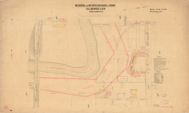
Plan, Melbourne & Metropolitan Board of Works : Borough of Kew : Detail Plan No.1301, 1910
... The gardens of the two David Syme owned mansions of ‘Blythswood’ and ‘Rockingham’, stretching down to the River Yarra, are also represented. Melbourne & Metropolitan Board of Works : Borough of Kew : Detail Plan No.1301 Plan Plan Melbourne and Metropolitan Board of Works ...The Melbourne and Metropolitan Board of Works (MMBW) plans were produced from the 1890s to the 1950s. They were crucial to the design and development of Melbourne's sewerage and drainage system. The plans, at a scale of 40 feet to 1 inch (1:480), provide a detailed historical record of Melbourne streetscapes and environmental features. Each plan covers one or two street blocks (roughly six streets), showing details of buildings, including garden layouts and ownership boundaries, and features such as laneways, drains, bridges, parks, municipal boundaries and other prominent landmarks as they existed at the time each plan was produced. (Source: State Library of Victoria)This plan forms part of a large group of MMBW plans and maps that was donated to the Society by the Mr Poulter, City Engineer of the City of Kew in 1989. Within this collection, thirty-five hand-coloured plans, backed with linen, are of statewide significance as they include annotations that provide details of construction materials used in buildings in the first decade of the 20th century as well as additional information about land ownership and usage. The copies in the Public Record Office Victoria and the State Library of Victoria are monochrome versions which do not denote building materials so that the maps in this collection are invaluable and unique tools for researchers and heritage consultants. A number of the plans are not held in the collection of the State Library of Victoria so they have the additional attribute of rarity.Original survey plan, issued by the MMBW to a contractor with responsibility for constructing sewers in the area identified on the plan within the Borough of Kew. The plan was at some stage hand-coloured, possibly by the contractor, but more likely by officers working in the Engineering Department of the Borough and later Town, then City of Kew. The hand-coloured sections of buildings on the plan were used to denote masonry or brick constructions (pink), weatherboard constructions (yellow), and public buildings (grey). Throughout its history, the land in what is known today as Studley Ward of the City of Boroondara has been subject to continuing subdivision. This is evident in Plan 1301, where later hands have modified the original map to include streets created subsequent to the printing of the plan in 1904. Other annotations such as the ‘Reserved for Road Purposes’ beside the Yarra never eventuated. The plan continued to be modified to at least 1953, when a later hand noted that a particular site was ‘Property site P. McIntyre house’ in Swinton Avenue. Two significant houses in the area are outlined on the plan: ‘Swinton’ on the corner of the streets then named Effey and Maud Streets (now Swinton Avenue) and ‘Fairhaven’ [unnamed] in Stevenson Street. The gardens of the two David Syme owned mansions of ‘Blythswood’ and ‘Rockingham’, stretching down to the River Yarra, are also represented.melbourne and metropolitan board of works, detail plans, mmbw 1301, cartography -
 Kew Historical Society Inc
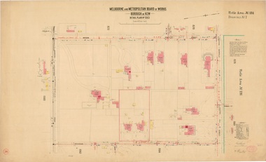
Plan, Melbourne & Metropolitan Board of Works : Borough of Kew : Detail Plan No.1563, 1905
... Kalimna and Blackhall are of significance as typical and intact late Victorian mansions and as such are two key Victorian buildings to have been built in Kew. ...Kalimna and Blackhall are of significance as typical and intact late Victorian mansions and as such are two key Victorian buildings to have been built in Kew. ...The Melbourne and Metropolitan Board of Works (MMBW) plans were produced from the 1890s to the 1950s. They were crucial to the design and development of Melbourne's sewerage and drainage system. The plans, at a scale of 40 feet to 1 inch (1:480), provide a detailed historical record of Melbourne streetscapes and environmental features. Each plan covers one or two street blocks (roughly six streets), showing details of buildings, including garden layouts and ownership boundaries, and features such as laneways, drains, bridges, parks, municipal boundaries and other prominent landmarks as they existed at the time each plan was produced. (Source: State Library of Victoria)This plan forms part of a large group of MMBW plans and maps that was donated to the Society by the Mr Poulter, City Engineer of the City of Kew in 1989. Within this collection, thirty-five hand-coloured plans, backed with linen, are of statewide significance as they include annotations that provide details of construction materials used in buildings in the first decade of the 20th century as well as additional information about land ownership and usage. The copies in the Public Record Office Victoria and the State Library of Victoria are monochrome versions which do not denote building materials so that the maps in this collection are invaluable and unique tools for researchers and heritage consultants. A number of the plans are not held in the collection of the State Library of Victoria so they have the additional attribute of rarity.Original survey plan, issued by the MMBW to a contractor with responsibility for constructing sewers in the area identified on the plan within the Borough of Kew. The plan was at some stage hand-coloured, possibly by the contractor, but more likely by officers working in the Engineering Department of the Borough and later Town, then City of Kew. The hand-coloured sections of buildings on the plan were used to denote masonry or brick constructions (pink), weatherboard constructions (yellow), and public buildings (grey). This plan covers the area between Barkers Road, Wrixon Street, Sackville Street and Brougham Place, much of it now occupied by Carey Baptist Grammar and Preshil schools. This was an area of large and prestigious homes in 1903, some with formally laid-out gardens, such as ‘Tower Hill’ and ‘Opawa’. ‘Kalimna’ was built in 1890-91 for William H. Jarman, an accountant, and ‘Blackhall’ at the same time for W.H. Roberts. Blackhall was to be acquired by the Salvation Army in 1915 and renamed ‘Catherine Booth Girls’ Home’. The Home accommodated girls, aged between 4 and 16. Kalimna and Blackhall are of significance as typical and intact late Victorian mansions and as such are two key Victorian buildings to have been built in Kew. Both Blackhall and Kalimna are now part of Preshil. ‘Fairview’ was for a long time occupied by the Sisters of St. Joseph of Cluny as a care home for the elderly, but it is now part of Carey Grammar School, as are the grounds of ‘Wagga Merne’, ‘Weemutta’, ‘Blakely’, ‘Daheim’ and ‘Mildura’ (later ‘Urangeline’), the last being particularly impressive in 1903, with a tennis court, conservatory, outhouses, and two bathrooms!melbourne and metropolitan board of works, detail plans, mmbw 1563, cartography -
 Kew Historical Society Inc
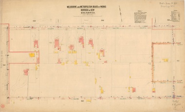
Plan, Melbourne & Metropolitan Board of Works : Borough of Kew : Detail Plan No.1564, 1905
... In 1905, when Plan No.1564 was printed, that part of Kew bordered by Brougham Place (now Daniell Place), Mount Street, Sackville Street and Ross Street was already the location of a number of large mansions. ...In 1905, when Plan No.1564 was printed, that part of Kew bordered by Brougham Place (now Daniell Place), Mount Street, Sackville Street and Ross Street was already the location of a number of large mansions. ...The Melbourne and Metropolitan Board of Works (MMBW) plans were produced from the 1890s to the 1950s. They were crucial to the design and development of Melbourne's sewerage and drainage system. The plans, at a scale of 40 feet to 1 inch (1:480), provide a detailed historical record of Melbourne streetscapes and environmental features. Each plan covers one or two street blocks (roughly six streets), showing details of buildings, including garden layouts and ownership boundaries, and features such as laneways, drains, bridges, parks, municipal boundaries and other prominent landmarks as they existed at the time each plan was produced. (Source: State Library of Victoria)This plan forms part of a large group of MMBW plans and maps that was donated to the Society by the Mr Poulter, City Engineer of the City of Kew in 1989. Within this collection, thirty-five hand-coloured plans, backed with linen, are of statewide significance as they include annotations that provide details of construction materials used in buildings in the first decade of the 20th century as well as additional information about land ownership and usage. The copies in the Public Record Office Victoria and the State Library of Victoria are monochrome versions which do not denote building materials so that the maps in this collection are invaluable and unique tools for researchers and heritage consultants. A number of the plans are not held in the collection of the State Library of Victoria so they have the additional attribute of rarity.Original survey plan, issued by the MMBW to a contractor with responsibility for constructing sewers in the area identified on the plan within the Borough of Kew. The plan was at some stage hand-coloured, possibly by the contractor, but more likely by officers working in the Engineering Department of the Borough and later Town, then City of Kew. The hand-coloured sections of buildings on the plan were used to denote masonry or brick constructions (pink), weatherboard constructions (yellow), and public buildings (grey). In 1905, when Plan No.1564 was printed, that part of Kew bordered by Brougham Place (now Daniell Place), Mount Street, Sackville Street and Ross Street was already the location of a number of large mansions. Here, subdivisions, at least at this stage, produced larger blocks than in Central Kew. Many of the houses on this plan are named: ‘Faybrook’, ‘Northumbria’, ‘Parkholm[e]’, ‘Dunboe’, ‘Katoomba’ and ‘Eschol’ fronting Sackville Street. Eschol was once the home of the manufacturer Robert Harrison, whose cordial factory in Spring and Argyle Streets Fitzroy are noted on the Victorian Heritage Register. ‘The Hawthorns’ on the corner of Brougham Place and Mount Street was the home of the medical practitioner Frank William Fay, who won the military cross and other honours for conspicuous gallantry and devotion to duty in World War 1.melbourne and metropolitan board of works, detail plans, mmbw 1564, cartography -
 Kew Historical Society Inc
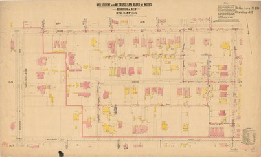
Plan, Melbourne & Metropolitan Board of Works : Borough of Kew : Detail Plan No.1575, 1905
... As one of the highest points in Kew, as expected, there were already some significant mansions built on large allotments of land. ...As one of the highest points in Kew, as expected, there were already some significant mansions built on large allotments of land. ...The Melbourne and Metropolitan Board of Works (MMBW) plans were produced from the 1890s to the 1950s. They were crucial to the design and development of Melbourne's sewerage and drainage system. The plans, at a scale of 40 feet to 1 inch (1:480), provide a detailed historical record of Melbourne streetscapes and environmental features. Each plan covers one or two street blocks (roughly six streets), showing details of buildings, including garden layouts and ownership boundaries, and features such as laneways, drains, bridges, parks, municipal boundaries and other prominent landmarks as they existed at the time each plan was produced. (Source: State Library of Victoria)This plan forms part of a large group of MMBW plans and maps that was donated to the Society by the Mr Poulter, City Engineer of the City of Kew in 1989. Within this collection, thirty-five hand-coloured plans, backed with linen, are of statewide significance as they include annotations that provide details of construction materials used in buildings in the first decade of the 20th century as well as additional information about land ownership and usage. The copies in the Public Record Office Victoria and the State Library of Victoria are monochrome versions which do not denote building materials so that the maps in this collection are invaluable and unique tools for researchers and heritage consultants. A number of the plans are not held in the collection of the State Library of Victoria so they have the additional attribute of rarity.Original survey plan, issued by the MMBW to a contractor with responsibility for constructing sewers in the area identified on the plan within the Borough of Kew. The plan was at some stage hand-coloured, possibly by the contractor, but more likely by officers working in the Engineering Department of the Borough and later Town, then City of Kew. The hand-coloured sections of buildings on the plan were used to denote masonry or brick constructions (pink), weatherboard constructions (yellow), and public buildings (grey). Plan No.1575 shows that in the area bounded by Wellington Street, Edgevale Road, Glenferrie Road, and Cotham Road, there had already been significant subdivision of land and houses constructed. As one of the highest points in Kew, as expected, there were already some significant mansions built on large allotments of land. Many of these mansions are identified by name on the plan such as ‘Kelso’, ‘Abbotsford’, ‘Clarendon’ and ‘Ashlyn’ in Cotham Road. Other houses of equal size are unnamed on the plan.melbourne and metropolitan board of works, detail plans, maps - borough of kew, mmbw 1575, cartography -
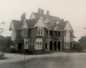 Kew Historical Society Inc
Photograph, 'Campion Hall', Studley Park Road, c.1960
... kew (vic.)...campion house -- campion hall...dalsraith -- dalswraith...glendalough...mansions...Together it forms the largest privately-donated collection within the archives of the Kew Historical Society. historic houses -- kew (vic.) campion house -- campion hall dalsraith -- dalswraith glendalough mansions -- studley park road -- kew (vic) ussher and kemp "17" Small black and white photograph of 'Campion Hall' (also known as Dalsraith, Dalswraith, Glendalough) in Studley Park Road, Kew. ...This work forms part of the collection assembled by the historian Dorothy Rogers, that was donated to the Kew Historical Society by her son John Rogers in 2015. The manuscripts, photographs, maps, and documents were sourced by her from both family and local collections or produced as references for her print publications. Many were directly used by Rogers in writing ‘Lovely Old Homes of Kew’ (1961) and 'A History of Kew' (1973), or the numerous articles on local history that she produced for suburban newspapers. Most of the photographs in the collection include detailed annotations in her hand.The Rogers Collection provides a comprehensive insight into the working habits of a historian in the 1960s and 1970s. Together it forms the largest privately-donated collection within the archives of the Kew Historical Society.Small black and white photograph of 'Campion Hall' (also known as Dalsraith, Dalswraith, Glendalough) in Studley Park Road, Kew."17"historic houses -- kew (vic.), campion house -- campion hall, dalsraith -- dalswraith, glendalough, mansions -- studley park road -- kew (vic), ussher and kemp
