Showing 14 items matching "lake fyans"
-
 Stawell Historical Society Inc
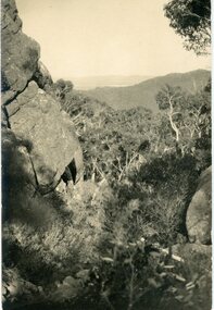
Postcard, Track to Mackey's Peak Showing Lake Fyans in Distance in the Grampians -- Postcard
... Track to Mackey's Peak Showing Lake Fyans in Distance in the Grampians -- Postcard...Photographic post card of track to Mackey's Peak showing Lake Fyans in distance "The Grampians"....Post Card Kodak Australia written in pencil on the back "The Track to Mackey's peak showing Lake Fyan's in distance"....Track to Mackey's Peak Showing Lake Fyans in Distance in the Grampians -- Postcard Postcard ...Photographic post card of track to Mackey's Peak showing Lake Fyans in distance "The Grampians".Black and white photograph of a bush scene with mountain views.Post Card Kodak Australia written in pencil on the back "The Track to Mackey's peak showing Lake Fyan's in distance".halls gap grampians -
 Stawell Historical Society Inc
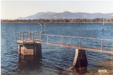
Photograph, Lake Fyans Photo -- Coloured
... Lake Fyans Photo -- Coloured...Framed Colour Photo Lake Fyans...Stawell Historical Society Inc 46 Longfield St Stawell grampians Framed Colour Photo Lake Fyans Stawell Lake Fyans Photo -- Coloured Photograph ...Framed Colour Photo Lake Fyansstawell -
 Stawell Historical Society Inc
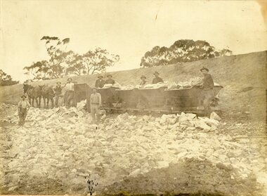
Photograph, Lake Fyans Main Bank Construction c1916
... Lake Fyans Main Bank Construction c1916...Working on the Main Bank at Lake Fyans c1916...Stawell Historical Society Inc 46 Longfield St Stawell grampians Working on the Main Bank at Lake Fyans c1916 Stawell Lake Fyans Main Bank Construction c1916 Photograph ...Working on the Main Bank at Lake Fyans c1916stawell -
 Stawell Historical Society Inc
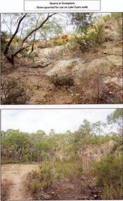
Photograph, Quarry in the Grampians -- Stone used for Lake Fyans Emabankment 2017
... Quarry in the Grampians -- Stone used for Lake Fyans Emabankment 2017 ...Quarry in Grampians Stone used for Lake Fyans Wall...Stawell Historical Society Inc 46 Longfield St Stawell grampians Quarry in Grampians Stone used for Lake Fyans Wall Stawell Quarry in the Grampians -- Stone used for Lake Fyans Emabankment 2017 Photograph ...Quarry in Grampians Stone used for Lake Fyans Wallstawell -
 Stawell Historical Society Inc
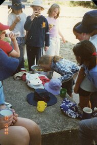
Photograph, Stawell Girl Guides Activities at Bastin Park --- Opposite Lake Fyans -- 2 Photos
... Stawell Girl Guides Activities at Bastin Park --- Opposite Lake Fyans -- 2 Photos...Bastin Park - Guides. Opposite Lake Fyans Two photographs ...Stawell Historical Society Inc 46 Longfield St Stawell grampians Bastin Park - Guides. Opposite Lake Fyans Two photographs Stawell Stawell Girl Guides Activities at Bastin Park --- Opposite Lake Fyans -- 2 Photos Photograph ...Bastin Park - Guides. Opposite Lake Fyans Two photographs stawell -
 Stawell Historical Society Inc
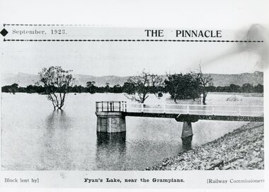
Photograph, Lake Fyans with outlet control Photo in the "The Pinnacle" High School Magazine 1923
... Lake Fyans with outlet control Photo in the "The Pinnacle" High School Magazine 1923 ...Lake Fyans with outlet control 1923 "The Pinnacle" High School Magazine...Stawell Historical Society Inc 46 Longfield St Stawell grampians Lake Fyans with outlet control 1923 "The Pinnacle" High School Magazine Stawell Lake Fyans with outlet control Photo in the "The Pinnacle" High School Magazine 1923 Photograph ...Lake Fyans with outlet control 1923 "The Pinnacle" High School Magazinestawell -
 Stawell Historical Society Inc
Photograph, Stawell Girl Guides Activities at Bastin Park --- Opposite Lake Fyans
... Stawell Girl Guides Activities at Bastin Park --- Opposite Lake Fyans ...Bastin Park - Guides. Opposite Lake Fyans Brick structure and Wooden Cross...Stawell Historical Society Inc 46 Longfield St Stawell grampians Bastin Park - Guides. Opposite Lake Fyans Brick structure and Wooden Cross Stawell Stawell Girl Guides Activities at Bastin Park --- Opposite Lake Fyans Photograph ...Bastin Park - Guides. Opposite Lake Fyans Brick structure and Wooden Crossstawell -
 Stawell Historical Society Inc
Book, Stawell Historical Society, Lake Fyans 1889 – 2006, 2006
... Lake Fyans 1889 – 2006...Stawell Historical Society Inc 46 Longfield St Stawell grampians stawell water Lake Fyans 1889 – 2006 Book Stawell Historical Society ...stawell water -
Federation University Historical Collection
Report, Read Sturgess and Associates Consulting Economists et al, The Economic Significance of Grampians National Park, 1994 (and other reports), 1990-4
... ...lake fyans...Barker Library (top floor) Mount Helen goldfields victorian tourisim industry tourism halls gap grampians grampians national park recreation water production bee keeping arapiles dunkeld balmoral pomonal wartook population agriculture water supplies minerals hamilton ararat stawell horsham wimmera koorie heritage aboriginal heritage koorie art sites brambuk waterways wannon river wimmera river mount william creek rocklands reservoir lake lonsdale lake fyans lake toolando cherrypool mirranatwa zumstein Notes in pencil by Mary Hollick, lecturer in Tourism at the University of Ballarat. .1) Grampians Surround Strategy, 1990 .2) Tourism and the Grampians Region: A Background Paper, 1990 .3) Grampians Surround Strategy and Discussion Paper, 1991 .4) The Economic Significance of Grampians National Park for the Department of Conservation and Natural Resources, 1994 The Economic Significance of Grampians National Park, 1994 (and other reports) Report Read Sturgess and Associates Consulting Economists Trevor Budge and Associates Victorian Tourism Commission Hassell Planning Consultants ....1) Grampians Surround Strategy, 1990 .2) Tourism and the Grampians Region: A Background Paper, 1990 .3) Grampians Surround Strategy and Discussion Paper, 1991 .4) The Economic Significance of Grampians National Park for the Department of Conservation and Natural Resources, 1994Notes in pencil by Mary Hollick, lecturer in Tourism at the University of Ballarat.victorian tourisim industry, tourism, halls gap, grampians, grampians national park, recreation, water production, bee keeping, arapiles, dunkeld, balmoral, pomonal, wartook, population, agriculture, water supplies, minerals, hamilton, ararat, stawell, horsham, wimmera, koorie heritage, aboriginal heritage, koorie art sites, brambuk, waterways, wannon river, wimmera river, mount william creek, rocklands reservoir, lake lonsdale, lake fyans, lake toolando, cherrypool, mirranatwa, zumstein -
 Stawell Historical Society Inc
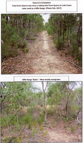
Photograph, A Track into Grampians Quarry -- Previously a Railway Line & Rifle Range Taken 2017 -- 2 Photos -- Coloured
... The rifle range was once the last part of the railway track that ran to the quarry which was used to cart stone to Lake Fyans when it was being constructed. (1912-1918). ...The rifle range was once the last part of the railway track that ran to the quarry which was used to cart stone to Lake Fyans when it was being constructed. (1912-1918). ...Two colour photographs of Track into Quarry Road Grampians. Once Rail Line used in construction of dam wall, later used as rifle range. The rifle range was once the last part of the railway track that ran to the quarry which was used to cart stone to Lake Fyans when it was being constructed. (1912-1918). The rifle butts are near to or part of the quarry. The Rifle range can still be seen. Two colour photographs of bush setting with track and dirt mound (rifle butts)stawell -
 Halls Gap & Grampians Historical Society
Photograph - B/W
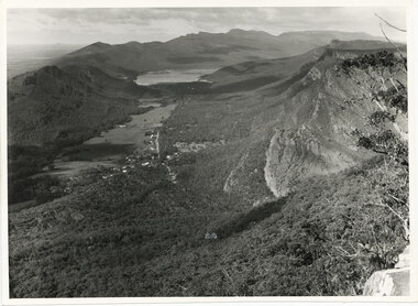
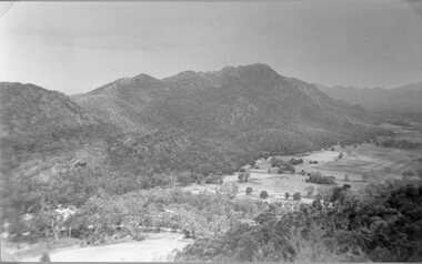
... The photo is of the Fyans Valley, taken from Chatauqua Peak. Lake Bellfield and Mount William can be seen in the background. ...Halls Gap & Grampians Historical Society Centennial Hall 117-119 Grampians Road Halls Gap grampians The photo is of the Fyans Valley, taken from Chatauqua Peak. Lake Bellfield and Mount William can be seen in the background. ...The photo is of the Fyans Valley, taken from Chatauqua Peak. Lake Bellfield and Mount William can be seen in the background. The photo belonged to the Forestry Commission Victoria.A photo of a valley between mountain ranges. A lake can be seen in the background. A road runs through the middle of the valley with houses on both sides."Fyans Vaslley from Chataqua Peak. Incl L. Bellfield & Halls Gap. photo belongs to F.C.V. Stawell. Return to V. Young, Horsham" written on back in green pencil. The "Chatauqua Peak" has been overwritten in black-lead pencil. "LC.71" is also written on the back in black-lead pencil.scenery, grampians ranges -
 Halls Gap & Grampians Historical Society
Photograph, C 1960s
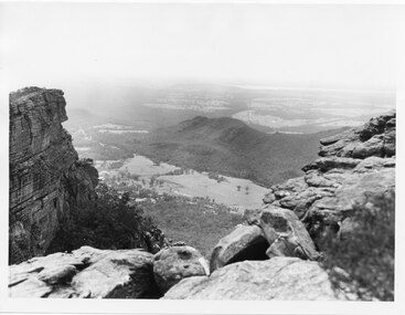
... SCENERY Fyans Valley Photo shows two rocky outcrops in the foreground framing a valley in the distance below. A partial view of a mountain range flanks the valley. Plains of trees and open fields, and also a lake ...The valley is known as Fyans Valley and the township of Halls Gap. Photo is typical of those taken by the Forestry Commission (Vic) during the 1960s.Photo shows two rocky outcrops in the foreground framing a valley in the distance below. A partial view of a mountain range flanks the valley. Plains of trees and open fields, and also a lake, can be seen beyond the mountain range. Within the valley in the middle of the photo buildings, roads and cleared land can be seen.scenery, fyans valley -
 Halls Gap & Grampians Historical Society
Photograph - B/W
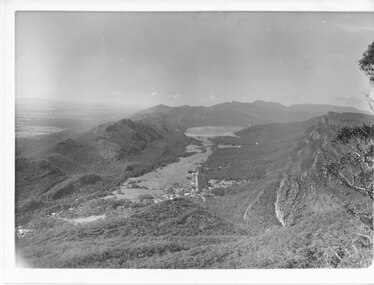
... Fyans Valley and the township of Halls Gap. The Grampians/Dunkeld Road can be seen running North/South along the right edge of the valley and Lake Bellfield is the water at the end of the valley. ...Fyans Valley and the township of Halls Gap. The Grampians/Dunkeld Road can be seen running North/South along the right edge of the valley and Lake Bellfield is the water at the end of the valley. ...Photo has been taken from Boroka Peak/lookout, of the Fyans Valley and the township of Halls Gap. The Grampians/Dunkeld Road can be seen running North/South along the right edge of the valley and Lake Bellfield is the water at the end of the valley. Photo is typical of those taken by Forrests Commission at the timea photo of a valley, mostly cleared, flanked by two mountain ranges. A large body of water can be seen at the far end of the valley (middle of photo). Buildings and roads visible in the valley. Plains can be seen beyond the far mountain range on the left side of the scene.no.42scenery, fyans valley -
 Stawell Historical Society Inc
Photograph, Fyans Valley in Halls Gap -- Before lake Belfield was constructed
... Fyans Valley. Halls Gap. Before lake Belfield constructed....Stawell Historical Society Inc 46 Longfield St Stawell grampians Fyans Valley. Halls Gap. Before lake Belfield constructed. ...Fyans Valley. Halls Gap. Before lake Belfield constructed.stawell