Showing 26 items matching "lake lonsdale"
-
 Stawell Historical Society Inc
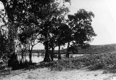
Photograph, View of Lake Lonsdale
... View of Lake Lonsdale...View of Lake Lonsdale....Stawell Historical Society Inc 46 Longfield St Stawell grampians View of Lake Lonsdale. Stawell View of Lake Lonsdale Photograph ...View of Lake Lonsdale.stawell -
 Stawell Historical Society Inc
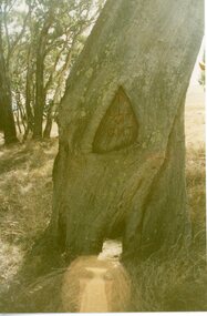
Photograph, Survey Tree with markings at Lake Lonsdale -- 2 Photos
... Survey Tree with markings at Lake Lonsdale -- 2 Photos...Survey Tree at Lake Lonsdale...Stawell Historical Society Inc 46 Longfield St Stawell grampians Survey Tree at Lake Lonsdale Stawell Survey Tree with markings at Lake Lonsdale -- 2 Photos Photograph ...Survey Tree at Lake Lonsdalestawell -
 Stawell Historical Society Inc
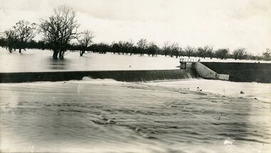
Photograph, Lake Lonsdale Weir in Flood
... Lake Lonsdale Weir in Flood...Lake Lonsdale Weir in Flood...Stawell Historical Society Inc 46 Longfield St Stawell grampians Lake Lonsdale Weir in Flood Stawell Lake Lonsdale Weir in Flood Photograph ...Lake Lonsdale Weir in Floodstawell -
 Stawell Historical Society Inc
Photograph, Lake Lonsdale Sand Bar c1935
... Lake Lonsdale Sand Bar c1935...Lake Lonsdale Sand Bar c1935...Stawell Historical Society Inc 46 Longfield St Stawell grampians Lake Lonsdale Sand Bar c1935 Stawell Lake Lonsdale Sand Bar c1935 Photograph ...Lake Lonsdale Sand Bar c1935stawell -
Stawell Historical Society Inc
Photograph, View to steps beside spillway Lake Lonsdale
... View to steps beside spillway Lake Lonsdale...View to steps beside spillway Lake Lonsdale...Stawell Historical Society Inc 46 Longfield St Stawell grampians View to steps beside spillway Lake Lonsdale Stawell View to steps beside spillway Lake Lonsdale Photograph ...View to steps beside spillway Lake Lonsdalestawell -
 Stawell Historical Society Inc
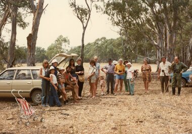
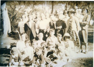
Photograph, Stawell Field Naturalists at Lake Lonsdale -- 5 Photos -- Coloured
... Stawell Field Naturalists at Lake Lonsdale -- 5 Photos -- Coloured...Stawell Field Naturalists – Lake Lonsdale Five photographs....Stawell Historical Society Inc 46 Longfield St Stawell grampians Stawell Field Naturalists – Lake Lonsdale Five photographs. Stawell Stawell Field Naturalists at Lake Lonsdale -- 5 Photos -- Coloured Photograph ...Stawell Field Naturalists – Lake Lonsdale Five photographs.stawell -
Stawell Historical Society Inc
Photograph, View across Lake Lonsdale Spillway Looking North
... View across Lake Lonsdale Spillway Looking North...View across Lake Lonsdale Spillway Looking North...Stawell Historical Society Inc 46 Longfield St Stawell grampians View across Lake Lonsdale Spillway Looking North Stawell View across Lake Lonsdale Spillway Looking North Photograph ...View across Lake Lonsdale Spillway Looking Northstawell -
Stawell Historical Society Inc
Photograph, View of spillway at Lake Lonsdale
... View of spillway at Lake Lonsdale...View of spillway Lake Lonsdale. House possibly Scoullar ...Stawell Historical Society Inc 46 Longfield St Stawell grampians View of spillway Lake Lonsdale. House possibly Scoullar Stawell View of spillway at Lake Lonsdale Photograph ...View of spillway Lake Lonsdale. House possibly Scoullar stawell -
 Stawell Historical Society Inc
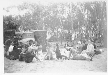
Photograph, Bradley & Johnston Families picnicing at Lake Lonsdale 1935
... Bradley & Johnston Families picnicing at Lake Lonsdale 1935...Picnic at Lake Lonsdale - Bradley & Johnston Families 1935...Stawell Historical Society Inc 46 Longfield St Stawell grampians Picnic at Lake Lonsdale - Bradley & Johnston Families 1935 Stawell Bradley & Johnston Families picnicing at Lake Lonsdale 1935 Photograph ...Picnic at Lake Lonsdale - Bradley & Johnston Families 1935stawell -
 Stawell Historical Society Inc
Photograph, Lake Lonsdale Sand Bar -- Part of the Water Supply to the Wimmera
... Lake Lonsdale Sand Bar -- Part of the Water Supply to the Wimmera....Lake Lonsdale Sand Bar. Part of the water Supply to the Wimmera....Stawell Historical Society Inc 46 Longfield St Stawell grampians Lake Lonsdale Sand Bar. Part of the water Supply to the Wimmera. stawell Lake Lonsdale Sand Bar -- Part of the Water Supply to the Wimmera. ...Lake Lonsdale Sand Bar. Part of the water Supply to the Wimmera.stawell -
 Stawell Historical Society Inc
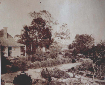
Photograph, "Rosehill" Station owned by Scoullar & Brinkman on shores of Lake Lonsdale 1872
... "Rosehill" Station owned by Scoullar & Brinkman on shores of Lake Lonsdale 1872...(Scoullar & Brinkman) Homestead on shores of Lake Lonsdale 1872...(Scoullar & Brinkman) Homestead on shores of Lake Lonsdale 1872 Stawell "Rosehill" Station owned by Scoullar & Brinkman on shores of Lake Lonsdale 1872 Photograph ...Rosehill Station. (Scoullar & Brinkman) Homestead on shores of Lake Lonsdale 1872stawell -
 Stawell Historical Society Inc
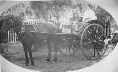
Photograph, Mr Archibald Hewitson & Mrs Archibald Hewitson nee Unknown from the Lake Lonsdale area
... Mr Archibald Hewitson & Mrs Archibald Hewitson nee Unknown from the Lake Lonsdale area...Archibald Hewitson in their Gig. Lived in Lake Lonsdale area....Archibald Hewitson in their Gig. Lived in Lake Lonsdale area. Stawell Mr Archibald Hewitson & Mrs Archibald Hewitson nee Unknown from the Lake Lonsdale area Photograph ...Deep Lead – Portrait Mr. & Mrs. Archibald Hewitson in their Gig. Lived in Lake Lonsdale area.stawell -
 Stawell Historical Society Inc
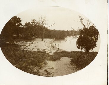
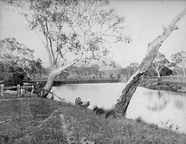
Photograph, Scene near Lake Lonsdale at Rosehill Station 1872
... Scene near Lake Lonsdale at Rosehill Station 1872...Scene near Lake Lonsdale 1872 at Rosehill Station (Scoullar and Brinkman) Taken for the Philadelphian Exhibition Similar to Cat No 1309 photo taken by Armstrong 1866...Gentleman in top Hat near tree on left. Scene near Lake Lonsdale at Rosehill Station 1872 Photograph ...Scene near Lake Lonsdale 1872 at Rosehill Station (Scoullar and Brinkman) Taken for the Philadelphian Exhibition Similar to Cat No 1309 photo taken by Armstrong 1866Lake Scene with lake and men in punt. Gentleman in top Hat near tree on left.Part of Rosehill Station near Grampians Mountains (Scoullar and Brinkman) Taken for the Philadelphia Exhibition 1872stawell -
 Stawell Historical Society Inc
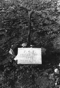
Photograph, Plaque made by Mr Hurley & placed in the middle of Lake Lonsdale when dried up 1968
... Plaque made by Mr Hurley & placed in the middle of Lake Lonsdale when dried up 1968...Photograph of Plaque placed in the middle of Lake Lonsdale when dry in March 1968 by Presbyterian Church Paterson Campbell Fellowship. ...Stawell Historical Society Inc 46 Longfield St Stawell grampians Photograph of Plaque placed in the middle of Lake Lonsdale when dry in March 1968 by Presbyterian Church Paterson Campbell Fellowship. ...Photograph of Plaque placed in the middle of Lake Lonsdale when dry in March 1968 by Presbyterian Church Paterson Campbell Fellowship. Plaque made by Mr Hurley father of Lyn Hurley. Many years later a reunion was held when the lake was once again dry. They could not find the plaque.P.C.F. Passed this spot March 1968 -
 Stawell Historical Society Inc
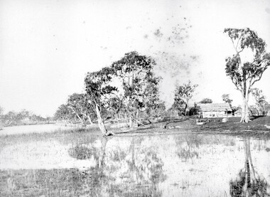
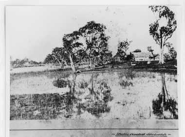
Photograph, "Schoolers" Homestead at Lake Lonsdale 1866
... "Schoolers" Homestead at Lake Lonsdale 1866...Schoolers Homestead Lake Lonsdale. Part of a collection of Photographs by Mr. ...Stawell Historical Society Inc 46 Longfield St Stawell grampians Schoolers Homestead Lake Lonsdale. Part of a collection of Photographs by Mr. ...Schoolers Homestead Lake Lonsdale. Part of a collection of Photographs by Mr. O.G. Armstrong as commissioned by the Shire of Stawell for the Inter-colonial and Paris Exhibition in Melbourne in 1866. Similar Photo Scoullar station Rosehill Cat No 3888 G.F. Scoullar originally from Canada, according to W.G. Sharply in his 1930 Stawell Borough History, was a member of the Stawell Shire Council 1870-1888 and president 1875-1876. Maynard Ord in Stawell Past and Present says G.F. Scoullar, M. Brinkman and one other, took up small pieces of land fronting Lake Lonsdale. The owners of the Squatting Run, presumably Ledcourt, charged them with illegal occupation. They were heavily fined at Pleasant Creek Court, or in default gaol. As they could not afford the fine, some friends raise the money. Note re the spelling of ‘Schooler’. Variations in local records are ‘Schoullar’ and ‘Scoullar’. stawell education -
 Stawell Historical Society Inc
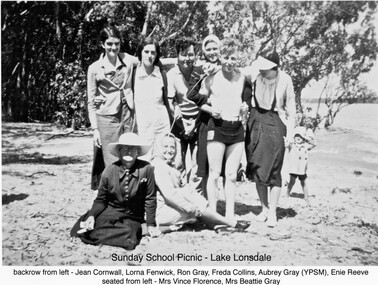
Photograph, Sunday School Picnic - Lake Lonsdale. Salvation Army
... Sunday School Picnic - Lake Lonsdale. Salvation Army...Seated from Left: Mrs Vince Florence, Mrs Beatie Gray Sunday School Picnic Group of people on beach some in bathing gear Sunday School Picnic - Lake Lonsdale. Salvation Army Photograph ...Back Row from Left: Jean Cornwell, Lorna Fenwick, Ron Gray, Freda Collins, Aubrey Gray (YPSM) Enie Reeve. Seated from Left: Mrs Vince Florence, Mrs Beatie Gray Group of people on beach some in bathing gearSunday School Picnic -
Federation University Historical Collection
Report, Read Sturgess and Associates Consulting Economists et al, The Economic Significance of Grampians National Park, 1994 (and other reports), 1990-4
... ...lake lonsdale...Barker Library (top floor) Mount Helen goldfields victorian tourisim industry tourism halls gap grampians grampians national park recreation water production bee keeping arapiles dunkeld balmoral pomonal wartook population agriculture water supplies minerals hamilton ararat stawell horsham wimmera koorie heritage aboriginal heritage koorie art sites brambuk waterways wannon river wimmera river mount william creek rocklands reservoir lake lonsdale lake fyans lake toolando cherrypool mirranatwa zumstein Notes in pencil by Mary Hollick, lecturer in Tourism at the University of Ballarat. .1) Grampians Surround Strategy, 1990 .2) Tourism and the Grampians Region: A Background Paper, 1990 .3) Grampians Surround Strategy and Discussion Paper, 1991 .4) The Economic Significance of Grampians National Park for the Department of Conservation and Natural Resources, 1994 The Economic Significance of Grampians National Park, 1994 (and other reports) Report Read Sturgess and Associates Consulting Economists Trevor Budge and Associates Victorian Tourism Commission Hassell Planning Consultants ....1) Grampians Surround Strategy, 1990 .2) Tourism and the Grampians Region: A Background Paper, 1990 .3) Grampians Surround Strategy and Discussion Paper, 1991 .4) The Economic Significance of Grampians National Park for the Department of Conservation and Natural Resources, 1994Notes in pencil by Mary Hollick, lecturer in Tourism at the University of Ballarat.victorian tourisim industry, tourism, halls gap, grampians, grampians national park, recreation, water production, bee keeping, arapiles, dunkeld, balmoral, pomonal, wartook, population, agriculture, water supplies, minerals, hamilton, ararat, stawell, horsham, wimmera, koorie heritage, aboriginal heritage, koorie art sites, brambuk, waterways, wannon river, wimmera river, mount william creek, rocklands reservoir, lake lonsdale, lake fyans, lake toolando, cherrypool, mirranatwa, zumstein -
Stawell Historical Society Inc
Dab Wyrrung Greenstone Axe, Hand Axe
... First People's Stone Axe. Found 1960's Lake Lonsdale by Alan Tangey - Brought home for children. ...Stawell Historical Society Inc 46 Longfield St Stawell grampians First People's Stone Axe. Found 1960's Lake Lonsdale by Alan Tangey - Brought home for children. ...First People's Stone Axe. Found 1960's Lake Lonsdale by Alan Tangey - Brought home for children. Mt Dryden quarry was where it came from. Pre European SettlementGreenstone- Oval - Smooth / Rough Surface. Rougher surface holding thumb Indent -
 Halls Gap & Grampians Historical Society
Photograph - B/W, c 1869
... Photo is said to be of Schoolers' homestead,Lake Lonsdale. Miss Scouller was the teacher at Halls Gap Primary school in 1921.Spelling of Schooler varies from that on front of photo to 'Scouller' which appears in book "Bridging the Gap'....Halls Gap & Grampians Historical Society Centennial Hall 117-119 Grampians Road Halls Gap grampians Photo is said to be of Schoolers' homestead,Lake Lonsdale. Miss Scouller was the teacher at Halls Gap Primary school in 1921.Spelling of Schooler varies from that on front of photo to 'Scouller' which appears in book "Bridging the Gap'. ...Photo is said to be of Schoolers' homestead,Lake Lonsdale. Miss Scouller was the teacher at Halls Gap Primary school in 1921.Spelling of Schooler varies from that on front of photo to 'Scouller' which appears in book "Bridging the Gap'.Photo shows bark roofed building on a bank of a body of water . A number of large gum trees surround the buildings-- tree reflections can be seen in the water. There appears to be extensive fencing around the buildings. The homestead is not visible.buildings, houses -
 Stawell Historical Society Inc
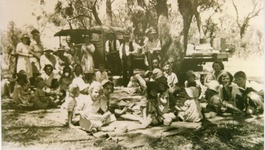
Photograph, School Picnic at the Sandbar Circa 1946
... Circa 1946 School Picnic at the Sandbar (Lake Lonsdale) Annie Richards, Edie Cray, Alf Cray, Amy Cray, Mrs. ...Stawell Historical Society Inc 46 Longfield St Stawell grampians Circa 1946 School Picnic at the Sandbar (Lake Lonsdale) Annie Richards, Edie Cray, Alf Cray, Amy Cray, Mrs. ...Circa 1946 School Picnic at the Sandbar (Lake Lonsdale) Annie Richards, Edie Cray, Alf Cray, Amy Cray, Mrs. Cray Snr., Kathleen Bennett, Alf Cray Sbr., Jack Cray, George Richards, Joan Gardy (teacher), Bill Cray, Mick Martin, Frank Cray. B/W Photo Group of people outside, children seated, adults standing, period truck and trees in backgrounddeep lead school, education -
 Stawell Historical Society Inc
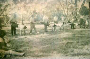
Photograph, Wheelbarrow Race
... Circa 1946 School Picnic at the Sandbar (Lake Lonsdale) Annie Richards, Edie Cray, Alf Cray, Amy Cray, Mrs. ...Stawell Historical Society Inc 46 Longfield St Stawell grampians Circa 1946 School Picnic at the Sandbar (Lake Lonsdale) Annie Richards, Edie Cray, Alf Cray, Amy Cray, Mrs. ...Circa 1946 School Picnic at the Sandbar (Lake Lonsdale) Annie Richards, Edie Cray, Alf Cray, Amy Cray, Mrs. Cray Snr., Kathleen Bennett, Alf Cray Sbr., Jack Cray, George Richards, Joan Gardy (teacher), Bill Cray, Mick Martin, Frank Cray. 2 B/W Photos Mens wheelbarrow race. 3031-29 Race Underway. 3031-29a, Waiting for the Start deep lead school, education -
 Stawell Historical Society Inc
Photograph, School Picnic at the Sandbar Circa 1940
... Circa 1940 School Picnic at the Sandbar (Lake Lonsdale) Standing: Annie Richards, Fred Richards, Des Repper, Mrs. ...Stawell Historical Society Inc 46 Longfield St Stawell grampians Circa 1940 School Picnic at the Sandbar (Lake Lonsdale) Standing: Annie Richards, Fred Richards, Des Repper, Mrs. ...Circa 1940 School Picnic at the Sandbar (Lake Lonsdale) Standing: Annie Richards, Fred Richards, Des Repper, Mrs. Repper, Bob McFeet, Perce Repper, Frank Bennett, ??, Alf Cray, Brian McFeet, ??, Amy Cray, Kathleen Bennett, ??, Baby, Margaret McFeet. Seated: ??, Leslie Bennett, ?? , ??, ??, Phyllis Repper, ??, Doug Repper, Laurie Benett, Doug McFeet, George Richards, ??.B/W Photo Large Group of People outside, Adults Standing at Rear, children seated in front.deep lead school, education -
Stawell Historical Society Inc
Photograph, Aerial Photos of Stawell from a Hot Air Balloon 1992 -- 12 Photos
... Grampians Range with Lake Lonsdale near center 7. Gold Reef Mall looking West 8. ...Grampians Range with Lake Lonsdale near center 7. Gold Reef Mall looking West 8. ...Series of 12 Aerial Photos of Stawell. Hot Air Balloon, October 1992 1. Cnr. Maude St & Grant Street 2. Maude St Napier Street & Railway cutting 3. Trotting Track 4. Roundabout Wimmera & Sloane Street 5. Florence Street towards Cato Lake & Park 6. Grampians Range with Lake Lonsdale near center 7. Gold Reef Mall looking West 8. Church Street looking West 9. Looking towards Black Range 10. Moonie Dams Darlington Road Leisure Complex 11. Stawell Gold Mine Evaporations Dams, Stawell Water Reservoirs, Moonie Dams 12. Darlington Road looking towards Black RangeSeries of 12 colour photographs from the Air.stawell -
Stawell Historical Society Inc
Photograph, Aerial Photos of Stawell from a Hot Air Balloon 1985 -- 11 Photos
... Looking back at Stawell. 10. Grampians & Lake Lonsdale. 11. Over Deep Lead. ...Looking back at Stawell. 10. Grampians & Lake Lonsdale. 11. Over Deep Lead. stawell Series of 11 colour photographs of aerial photos of balloon rides over a town. ...Series of 11 Aerial Photos of Stawell. Hot Air Balloon 1985. Photo were taken during a second balloon ride in July 1985. Take off venue was the oval at Stawell West Primary School. The balloon course was parallel to the Western Highway out over Deep Lead. 1. Ride left from Stawell West Primary Oval. 2. School Children were brought out to see the balloon launch. 3. Western Highway Green School oval. 4. Central Park Lower Main St. 5. Taylor's Gully Park Sloane St. 6. Shadow of Hot Air balloon on low cloud over Western Highway. 7. North Western Woollen Mills. 8. Pleasant Creek special school. 9. Looking back at Stawell. 10. Grampians & Lake Lonsdale. 11. Over Deep Lead. Series of 11 colour photographs of aerial photos of balloon rides over a town. stawell -
 Stawell Historical Society Inc
Photograph, Carrs Plains Wettenhall CD, 2006
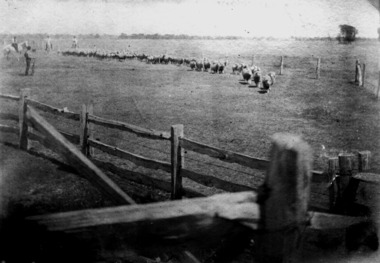
... 5563-2a Sheep Carrs Plains 5563-2a1 Carrs Plains on bank of Richardson River 5563-2a2 Carrs Plains Molly with Calf 5563-2b Richardson River in Flood 5563-2b1 Carrs Plains 5563-2b2 Arthur Whettenhall at front door 5563-2c Slush boxes Carrs Plains 5563-2c1 Carrs Plains 5563-2c2 Wettenhall Family1890 Viola on Holford's lap 5563-2d Seven Bros 5563-2d1 Carrs Plains 5563-2d2 Snow at Carrs Plains about 1896 5563-2e Carrs Plains 5563-2e1 Carrs Plains 5563-2e2 Carrs Plains Quarters 5563-2f Sheep 5563-2f1 Carrs Plains 5563-2f2 Sheep & Fleece 5563-2g Sheep 5563-2g1 Carrs Plains 5563-2g2 Carrs Plains Staff 5563-2h Alan Wettenhall 5563-2h1 Carrs Plains 5563-2h2 Portrait of 5563-2i Carrs Plains Grp 5563-2i1 Mr Tom Thumb the pony at Carrs Plains 5563-2i2 CP Top Sheep 5563-2j Roland Viola Alexander 5563-2j1 H H Wettenhall 5563-2j2 Carrs Plains Riding 5563-2k Sheep 5563-2k1 H H Wettenhall 5563-2k2 Carrs Plains sheep 5563-2l Carrs Plains front door on R 5563-2l1 H H Wettenhall false left arm 5563-2l2 Carrs Plains slush box 5563-2m Carrs Plains Rams 5563-2m1 H H Wettenhall 5563-2m2 Carrs Plains wool away 5563-2n Carrs Plains 5563-2n1 Carrs Plains 5563-2n2 Snow at Carrs Plains 5563-2o Carrs Plains Shearing 5563-2o1 Shoot 5563-2p Carrs Plains Shearing 5563-2p1 Party At Dam possibly Lake Lonsdale 5563-2q Carrs Plains Sheep 5563-2q1 Carrs PLains 5563-2r Carrs Plains Sheep 5563-2r1 Carrs Plains 5563-2s Carrs Plains Flood 5563-2s1 Carrs Plains 5563-2t Carrs Plains Flood 5563-2t1 Carrs Plains Duck 5563-2u Carrs Plains Flood 5563-2u1 Carrs Plains Sheep 5563-2v Veranda Carrs Plains 5563-2v1 Mrs Tom Thumbs Foal Tempus 5563-2w Carrs Plains Flood 5563-2w1 Molly and her Kemp family ,her mother Euphemia and Gd Mother Kemp 5563-2x Carrs Plains Flood 5563-2x1 Jean Kemp Molly's oldest sister 1909 5563-2y Carrs Plains Barns 5563-2y1 G G Mother Kemp 94yrs Herbert on R 5563-2z Carrs Plains Playing 5563-2z1 Carrs Plains Buggy ...Stawell Historical Society Inc 46 Longfield St Stawell grampians 5563-2a Sheep Carrs Plains 5563-2a1 Carrs Plains on bank of Richardson River 5563-2a2 Carrs Plains Molly with Calf 5563-2b Richardson River in Flood 5563-2b1 Carrs Plains 5563-2b2 Arthur Whettenhall at front door 5563-2c Slush boxes Carrs Plains 5563-2c1 Carrs Plains 5563-2c2 Wettenhall Family1890 Viola on Holford's lap 5563-2d Seven Bros 5563-2d1 Carrs Plains 5563-2d2 Snow at Carrs Plains about 1896 5563-2e Carrs Plains 5563-2e1 Carrs Plains 5563-2e2 Carrs Plains Quarters 5563-2f Sheep 5563-2f1 Carrs Plains 5563-2f2 Sheep & Fleece 5563-2g Sheep 5563-2g1 Carrs Plains 5563-2g2 Carrs Plains Staff 5563-2h Alan Wettenhall 5563-2h1 Carrs Plains 5563-2h2 Portrait of 5563-2i Carrs Plains Grp 5563-2i1 Mr Tom Thumb the pony at Carrs Plains 5563-2i2 CP Top Sheep 5563-2j Roland Viola Alexander 5563-2j1 H H Wettenhall 5563-2j2 Carrs Plains Riding 5563-2k Sheep 5563-2k1 H H Wettenhall 5563-2k2 Carrs Plains sheep 5563-2l Carrs Plains front door on R 5563-2l1 H H Wettenhall false left arm 5563-2l2 Carrs Plains slush box 5563-2m Carrs Plains Rams 5563-2m1 H H Wettenhall 5563-2m2 Carrs Plains wool away 5563-2n Carrs Plains 5563-2n1 Carrs Plains 5563-2n2 Snow at Carrs Plains 5563-2o Carrs Plains Shearing 5563-2o1 Shoot 5563-2p Carrs Plains Shearing 5563-2p1 Party At Dam possibly Lake Lonsdale 5563-2q Carrs Plains Sheep 5563-2q1 Carrs PLains 5563-2r Carrs Plains Sheep 5563-2r1 Carrs Plains 5563-2s Carrs Plains Flood 5563-2s1 Carrs Plains 5563-2t Carrs Plains Flood 5563-2t1 Carrs Plains Duck 5563-2u Carrs Plains Flood 5563-2u1 Carrs Plains Sheep 5563-2v Veranda Carrs Plains 5563-2v1 Mrs Tom Thumbs Foal Tempus 5563-2w Carrs Plains Flood 5563-2w1 Molly and her Kemp family ,her mother Euphemia and Gd Mother Kemp 5563-2x Carrs Plains Flood 5563-2x1 Jean Kemp Molly's oldest sister 1909 5563-2y Carrs Plains Barns 5563-2y1 G G Mother Kemp 94yrs Herbert on R 5563-2z Carrs Plains Playing 5563-2z1 Carrs Plains Buggy Stawell Photographs of Carrs Plain on CD Carrs Plains Wettenhall CD Photograph ...5563-2a Sheep Carrs Plains 5563-2a1 Carrs Plains on bank of Richardson River 5563-2a2 Carrs Plains Molly with Calf 5563-2b Richardson River in Flood 5563-2b1 Carrs Plains 5563-2b2 Arthur Whettenhall at front door 5563-2c Slush boxes Carrs Plains 5563-2c1 Carrs Plains 5563-2c2 Wettenhall Family1890 Viola on Holford's lap 5563-2d Seven Bros 5563-2d1 Carrs Plains 5563-2d2 Snow at Carrs Plains about 1896 5563-2e Carrs Plains 5563-2e1 Carrs Plains 5563-2e2 Carrs Plains Quarters 5563-2f Sheep 5563-2f1 Carrs Plains 5563-2f2 Sheep & Fleece 5563-2g Sheep 5563-2g1 Carrs Plains 5563-2g2 Carrs Plains Staff 5563-2h Alan Wettenhall 5563-2h1 Carrs Plains 5563-2h2 Portrait of 5563-2i Carrs Plains Grp 5563-2i1 Mr Tom Thumb the pony at Carrs Plains 5563-2i2 CP Top Sheep 5563-2j Roland Viola Alexander 5563-2j1 H H Wettenhall 5563-2j2 Carrs Plains Riding 5563-2k Sheep 5563-2k1 H H Wettenhall 5563-2k2 Carrs Plains sheep 5563-2l Carrs Plains front door on R 5563-2l1 H H Wettenhall false left arm 5563-2l2 Carrs Plains slush box 5563-2m Carrs Plains Rams 5563-2m1 H H Wettenhall 5563-2m2 Carrs Plains wool away 5563-2n Carrs Plains 5563-2n1 Carrs Plains 5563-2n2 Snow at Carrs Plains 5563-2o Carrs Plains Shearing 5563-2o1 Shoot 5563-2p Carrs Plains Shearing 5563-2p1 Party At Dam possibly Lake Lonsdale 5563-2q Carrs Plains Sheep 5563-2q1 Carrs PLains 5563-2r Carrs Plains Sheep 5563-2r1 Carrs Plains 5563-2s Carrs Plains Flood 5563-2s1 Carrs Plains 5563-2t Carrs Plains Flood 5563-2t1 Carrs Plains Duck 5563-2u Carrs Plains Flood 5563-2u1 Carrs Plains Sheep 5563-2v Veranda Carrs Plains 5563-2v1 Mrs Tom Thumbs Foal Tempus 5563-2w Carrs Plains Flood 5563-2w1 Molly and her Kemp family ,her mother Euphemia and Gd Mother Kemp 5563-2x Carrs Plains Flood 5563-2x1 Jean Kemp Molly's oldest sister 1909 5563-2y Carrs Plains Barns 5563-2y1 G G Mother Kemp 94yrs Herbert on R 5563-2z Carrs Plains Playing 5563-2z1 Carrs Plains Buggy Photographs of Carrs Plain on CDstawell -
 Kew Historical Society Inc
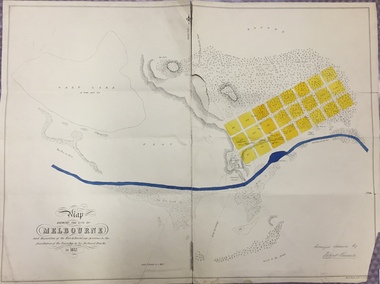
Map, Robert Russell, Map Shewing the Site of Melbourne and the Position of the Huts & Buildings Previous to the Foundation of the Township by Sir Richard Bourke in 1837
... The surveyed blocks extend from present-day Flinders Street to Lonsdale Street, and Spring Street to Spencer Street, with extensive vacant land west to a salt lake (afterwards Batman's Swamp, later drained), north beyond Flagstaff Hill and south towards South Melbourne. ...The surveyed blocks extend from present-day Flinders Street to Lonsdale Street, and Spring Street to Spencer Street, with extensive vacant land west to a salt lake (afterwards Batman's Swamp, later drained), north beyond Flagstaff Hill and south towards South Melbourne. ...Map shows the first layout of Melbourne by Government surveyor Robert Russell, who accompanied Governor Richard Bourke in 1837. The surveyed blocks extend from present-day Flinders Street to Lonsdale Street, and Spring Street to Spencer Street, with extensive vacant land west to a salt lake (afterwards Batman's Swamp, later drained), north beyond Flagstaff Hill and south towards South Melbourne. Vegetation coverage is indicated, and tracks and existing buildings and cultivated land are shown.Printed map was created by Day & Haghe, Lithographers to the Queen, sometime after 1838, when the company received its Royal appointment. Copies of the 1837 map exist in several major map collections in Australia; most are uncoloured. This particular map is the earliest in the Kew Historical Society's map collection. It is a nationally significant artefact. Black and white lithographed map hand-coloured in blue and yellow gouache of the town of Melbourne in 1837. In contrast to the original lithograph, the river and the township blocks are coloured blue and yellow. A similar, partly coloured copy is in the collection of the University of Melbourne.maps - melbourne - 1830s, governor sir richard bourke, robert russell - surveyor, cartography