Showing 63 items matching "lake road estate"
-
 Whitehorse Historical Society Inc.
Newspaper - Article, Lake Road Estate, 7/10/1970
... Lake Road Estate...Lake Road...Blackburn...Lake Road Estate...'It's a genuine piece of Bellbird country' [ article on 36 lot subdivision, Lake Road Estate, Lake Road, Blackburn by developers Mark Padgett and Co Pty Ltd]...Whitehorse Historical Society Inc. 2-10 Deep Creek Road Mitcham melbourne Mark Padgett & Co Pty Ltd Lake Road Blackburn Lake Road Estate Land Subdivision 'It's a genuine piece of Bellbird country' [ article on 36 lot subdivision, Lake Road Estate, Lake Road, Blackburn by developers Mark Padgett and Co Pty Ltd] Lake Road Estate Newspaper Article ...'It's a genuine piece of Bellbird country' [ article on 36 lot subdivision, Lake Road Estate, Lake Road, Blackburn by developers Mark Padgett and Co Pty Ltd]mark padgett & co pty ltd, lake road, blackburn, lake road estate, land subdivision -
Whitehorse Historical Society Inc.
Map, Lake Road estate Blackburn, c1960
... Lake Road estate Blackburn...Lake Road Estate...Plan of subdivision of Lake Road Estate, 36 sites. Agent: Mark Padgett & Co Pty Ltd....Lake Road estate Blackburn Map Map ...Plan of subdivision of Lake Road Estate, 36 sites.Plan of subdivision of Lake Road Estate, 36 sites. Agent: Mark Padgett & Co Pty Ltd.Plan of subdivision of Lake Road Estate, 36 sites. lake road estate, blackburn, lake road, blackburn, ottawa avenue, blackburn, anjaya court, blackburn, leons court, blackburn -
Marysville & District Historical Society
THE TRIANGLE NEWS-VOL 39 NO 11-MARCH 30 2012
... road at alexandra library...marysville real estate...buxton reserve news...marysville & district lions...maryton park b & b...marysville lake...Marysville & District Historical Society 39 Darwin Street Marysville yarra-valley-and-the-dandenong-ranges marysville victoria australia wirreanda children's festival what's on when in april the committee of management of the gallipoli park precinct yarra valley yoga creative triangle cultural community agm marysville golf report triangle bushwalkers church notices triangle community pot luck dinner advertisements murrindindi shire council dog/cat registrations marysville pharmacy marysville medical clinic beyong bushfires petra meer journal workshop mayor's chair ladies lunch saladin lodge expressions of interest memorials consultation tender stage two marysville & district sesquicentenary celebrations narbethong history group narbethong reunion narbethong hall emotions anonymous international meeting travel the silk road at alexandra library marysville real estate buxton reserve news marysville & district lions maryton park b & b marysville lake mountain visitor information centre public notice THE TRIANGLE NEWS-VOL 39 NO 11-MARCH 30 2012 ...marysville, victoria, australia, wirreanda children's festival, what's on when in april, the committee of management of the gallipoli park precinct, yarra valley yoga, creative triangle, cultural community agm, marysville golf report, triangle bushwalkers, church notices, triangle community pot luck dinner, advertisements, murrindindi shire council, dog/cat registrations, marysville pharmacy, marysville medical clinic, beyong bushfires, petra meer journal workshop, mayor's chair, ladies lunch, saladin lodge, expressions of interest, memorials consultation tender stage two, marysville & district sesquicentenary celebrations, narbethong history group, narbethong reunion, narbethong hall, emotions anonymous international meeting, travel the silk road at alexandra library, marysville real estate, buxton reserve news, marysville & district lions, maryton park b & b, marysville lake mountain visitor information centre, public notice -
Marysville & District Historical Society
THE TRIANGLE NEWS-VOL 39 NO 12-APRIL 6 2012
... road at alexandra library...alexandra library events...marysville triangle real estate...the lions triangle tool library...maryton park b & b...marysville beer & platter garden...marysville lake...Marysville & District Historical Society 39 Darwin Street Marysville yarra-valley-and-the-dandenong-ranges marysville victoria australia funding success for youth projects murrindindi youth partnership group council adopts youth strategy what's on where in april advertisements creative triangle cultural community agm guided walks cathedral range state park emotions anonymous international meeting murrindindi shire council dog/cat registration marysville pharmacy marysville golf report marysville sub branch rsl anzac day service mayor's chair 2012 season launch happy hour marysville community golf & bowls club marysville & district sesquicentenary celebrations marysville & district historical society meeting memory lane cafes travel the silk road at alexandra library alexandra library events marysville triangle real estate the lions triangle tool library maryton park b & b marysville beer & platter garden marysville lake mountain visitor information centre public notice marysville saddle tramps news ladies lunch saladin lodge councillor comment lake mountain alpine resort marysville medical centre news THE TRIANGLE NEWS-VOL 39 NO 12-APRIL 6 2012 ...marysville, victoria, australia, funding success for youth projects, murrindindi youth partnership group, council adopts youth strategy, what's on where in april, advertisements, creative triangle, cultural community agm, guided walks, cathedral range state park, emotions anonymous international meeting, murrindindi shire council, dog/cat registration, marysville pharmacy, marysville golf report, marysville sub branch rsl, anzac day service, mayor's chair, 2012 season launch, happy hour, marysville community golf & bowls club, marysville & district sesquicentenary celebrations, marysville & district historical society meeting, memory lane cafes, travel the silk road at alexandra library, alexandra library events, marysville triangle real estate, the lions triangle tool library, maryton park b & b, marysville beer & platter garden, marysville lake mountain visitor information centre, public notice, marysville saddle tramps news, ladies lunch, saladin lodge, councillor comment, lake mountain alpine resort, marysville medical centre news -
Marysville & District Historical Society
THE TRIANGLE NEWS-VOL 39 NO 14-APRIL 20 2012
... road closure anzac day march...pans on fire band...marysville & district sesquicentenary celebrations...energy quotes...bushfire volunteer group announces closure...alexandra library events...aust. centre for grief & bereavement...aust. in a3 car club...marysville triangle real estate...people & parks foundation...working bee...cathedral range new walking track...marysville beer & platter garden...maryton b & b...marysville lake...Marysville & District Historical Society 39 Darwin Street Marysville yarra-valley-and-the-dandenong-ranges marysville victoria australia lions aid speeds up quest for cure spinal cord injury lions spinal cord fellowship what's on when in april advertisements creative triangle marysville fire brigade yarra valley yoga triangle bushwalkers liberal party of australia marsyville triangle branch progressive lunch church notices murrindindi shire council notice of special meeting of council petra meer journal workshop marysville play group marysville pharmacy marysville medical clinic marysville sub branch rsl anzac day service 2012 season launch mayor's chair road closure anzac day march pans on fire band marysville & district sesquicentenary celebrations energy quotes bushfire volunteer group announces closure alexandra library events aust. centre for grief & bereavement aust. in a3 car club marysville triangle real estate people & parks foundation working bee cathedral range new walking track marysville beer & platter garden maryton b & b marysville lake mountain visitor information centre murrindindi planning scheme notice of amendment planning & environment act 1987 lake mountain alpine resort marysville medical centre THE TRIANGLE NEWS-VOL 39 NO 14-APRIL 20 2012 ...marysville, victoria, australia, lions aid speeds up quest for cure, spinal cord injury, lions spinal cord fellowship, what's on when in april, advertisements, creative triangle, marysville fire brigade, yarra valley yoga, triangle bushwalkers, liberal party of australia, marsyville triangle branch, progressive lunch, church notices, murrindindi shire council, notice of special meeting of council, petra meer journal workshop, marysville play group, marysville pharmacy, marysville medical clinic, marysville sub branch rsl, anzac day service, 2012 season launch, mayor's chair, road closure anzac day march, pans on fire band, marysville & district sesquicentenary celebrations, energy quotes, bushfire volunteer group announces closure, alexandra library events, aust. centre for grief & bereavement, aust. in a3 car club, marysville triangle real estate, people & parks foundation, working bee, cathedral range new walking track, marysville beer & platter garden, maryton b & b, marysville lake mountain visitor information centre, murrindindi planning scheme, notice of amendment, planning & environment act 1987, lake mountain alpine resort, marysville medical centre -
Marysville & District Historical Society
THE TRIANGLE NEWS-VOL 39 NO 24-JUNE 29 2012
... estate...works improve yea facilities...yea river...lake mountain alpine resort...works to improve break o'day road...Marysville & District Historical Society 39 Darwin Street Marysville yarra-valley-and-the-dandenong-ranges marysville victoria australia lions club changeover dinner friends of lions men's shed works start what's on when in july crafters circle craft day narbethong hall the committee of management of the gallipoli park precinct intrepid triangle bushwalkers creative triangle marysville & triangle youth group local residents honoured at 2021 queen's birthday advertisements marysville cricket club agm marsyville fire station church notices christmas in july community dinner marysville golf club men's breakfast igloo roadhouse taggerty community progress group taggerty hall committee marysville primary school artists in the acheron marysville villains football marysville pharmacy marysville medical clinic mayor's chair marysville golf report councillor comment marysville community market murrindindi shire council position vacant real estate works improve yea facilities yea river lake mountain alpine resort works to improve break o'day road THE TRIANGLE NEWS-VOL 39 NO 24-JUNE 29 2012 ...marysville, victoria, australia, lions club changeover dinner, friends of lions, men's shed works start, what's on when in july, crafters circle, craft day, narbethong hall, the committee of management of the gallipoli park precinct, intrepid triangle bushwalkers, creative triangle, marysville & triangle youth group, local residents honoured at 2021 queen's birthday, advertisements, marysville cricket club agm, marsyville fire station, church notices, christmas in july community dinner, marysville golf club, men's breakfast, igloo roadhouse, taggerty community progress group, taggerty hall committee, marysville primary school, artists in the acheron, marysville villains football, marysville pharmacy, marysville medical clinic, mayor's chair, marysville golf report, councillor comment, marysville community market, murrindindi shire council, position vacant, real estate, works improve yea facilities, yea river, lake mountain alpine resort, works to improve break o'day road -
 Phillip Island and District Historical Society Inc.
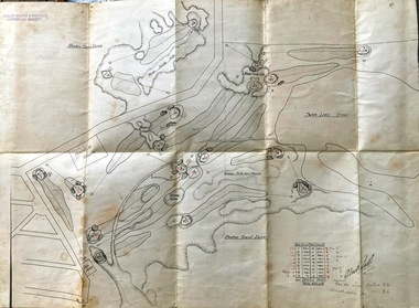
Map, Map of Summerland Golf Course, 15/12/1927
... estate, guest house and golf course. This area was acquired and all buildings, roads etc removed by the Victorian Government in the 1980s for a nature reserve for the penguins. This is believed to be the only time in the world when humans have been removed to benefit nature. Historical Summerland Estate A.K. T. Sampbell map penguin reserve Summerland Golf Course Broken sand dunes, rough sandy hills, grassy hills and mounds, Swan Lake ...Summerland Estate was created in the 1920s by A.K. T. Sampbell. It consisted of a housing estate, guest house and golf course. This area was acquired and all buildings, roads etc removed by the Victorian Government in the 1980s for a nature reserve for the penguins. This is believed to be the only time in the world when humans have been removed to benefit nature. HistoricalPurple leather covered fold out linen map with hand drawn diagram of the topography, layout of golf holes and club house Broken sand dunes, rough sandy hills, grassy hills and mounds, Swan Lake, Par for nine holes 34, Scratch score for nine holes 36, Drawn by A. Russell 12/12/1927summerland estate, a.k. t. sampbell, map, penguin reserve, summerland golf course -
 Ringwood and District Historical Society
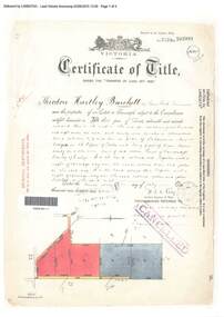
Document, Certificate of Title - Theodore Hartley Burchett - part of Crown Section 20, Parish of Warrandyte, County of Evelyn - 1911
... Theodore Hartley Burchett of Lara Lake, Farmer, is now the proprietor of an Estate in Fee-simple subject to the Encumbrances notified hereunder ... 180 acres 01 rood 27 perches or thereabouts, being lots 1, 8, 9 and 10 on plan of subdivision no.4315. Subdivision map includes un-named roads...Ringwood and District Historical Society 125A Warrandyte Road Ringwood North melbourne Theodore Hartley Burchett of Lara Lake, Farmer, is now the proprietor of an Estate in Fee-simple subject to the Encumbrances notified hereunder ... 180 acres 01 rood 27 perches or thereabouts, being lots 1, 8, 9 and 10 on plan of subdivision no.4315. ...A4 copies of Landata Victoria Historical Search documents - Vol 3520 Fol 703991.Theodore Hartley Burchett of Lara Lake, Farmer, is now the proprietor of an Estate in Fee-simple subject to the Encumbrances notified hereunder ... 180 acres 01 rood 27 perches or thereabouts, being lots 1, 8, 9 and 10 on plan of subdivision no.4315. Subdivision map includes un-named roads - lower western side is Wonga Road (later Warranwood Road), and eastern side is Grandview Grove (later Bemboka Road), both north of Plymouth Road, Ringwood, Vic. Transfers include Anna Maria Wicks and Henry James Trowbridge, 3rd October, 1911 Elizabeth Ann Walden, 18th September, 1912 - 28ac 3rds 5per. Edward Thomas Miles, 22nd September, 1913 - 27ac 19per. Samuel Styles, 10th October, 1916 - balance. -
 Ringwood and District Historical Society
Photograph, Looking west across Werac and Kubis Drives, North Ringwood, in April 1978. Loughnan's Lake site. The retaining wall was where the truck tracks disappear over thhe ridge. The spillway was at that spot
... Ringwood and District Historical Society 125A Warrandyte Road Ringwood North melbourne E548 N3 Part of a 51-photo record of the development of the "Kubis" Estate, Ringwood North, including road works to Debbie Place, Kubis Drive, Werac Drive, Manuelo Drive, Iluka Place and Glenvale Road. From the Jack Lundy Clarke collection. Looking west across Werac and Kubis Drives, North Ringwood, in April 1978. Loughnan's Lake ...E548 N3 Part of a 51-photo record of the development of the "Kubis" Estate, Ringwood North, including road works to Debbie Place, Kubis Drive, Werac Drive, Manuelo Drive, Iluka Place and Glenvale Road. From the Jack Lundy Clarke collection. -
 Ringwood and District Historical Society
Photograph, Looking from Werac Drive, North Ringwood, on 14th April 1978, across the site of the headwaters of Loughnan's Lake. Main body of water lay to the left (west)
... Ringwood and District Historical Society 125A Warrandyte Road Ringwood North melbourne E548 N7 Part of a 51-photo record of the development of the "Kubis" Estate, Ringwood North, including road works to Debbie Place, Kubis Drive, Werac Drive, Manuelo Drive, Iluka Place and Glenvale Road. From the Jack Lundy Clarke collection.51 Looking from Werac Drive, North Ringwood, on 14th April 1978, across the site of the headwaters of Loughnan's Lake. ...E548 N7 Part of a 51-photo record of the development of the "Kubis" Estate, Ringwood North, including road works to Debbie Place, Kubis Drive, Werac Drive, Manuelo Drive, Iluka Place and Glenvale Road. From the Jack Lundy Clarke collection.51 -
 Ringwood and District Historical Society
Photograph, Looking west from Kubis Drive, North Ringwood, in April 1978, over the full length of the site of Loughnan's Lake
... Ringwood and District Historical Society 125A Warrandyte Road Ringwood North melbourne E548 N5 Part of a 51-photo record of the development of the "Kubis" Estate, Ringwood North, including road works to Debbie Place, Kubis Drive, Werac Drive, Manuelo Drive, Iluka Place and Glenvale Road. From the Jack Lundy Clarke collection.51 Looking west from Kubis Drive, North Ringwood, in April 1978, over the full length of the site of Loughnan's Lake. ...E548 N5 Part of a 51-photo record of the development of the "Kubis" Estate, Ringwood North, including road works to Debbie Place, Kubis Drive, Werac Drive, Manuelo Drive, Iluka Place and Glenvale Road. From the Jack Lundy Clarke collection.51 -
 Ringwood and District Historical Society
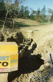
Photograph, The Kato working on the pumping plant at the end of the sewer trench near Glenvale Road, North Ringwood, on 10 June 1978. Loughnan's Lake site shown as a grassy hollow in the background
... Ringwood and District Historical Society 125A Warrandyte Road Ringwood North melbourne E550 N2 & N3 Part of a 51-photo record of the development of the "Kubis" Estate, Ringwood North, including road works to Debbie Place, Kubis Drive, Werac Drive, Manuelo Drive, Iluka Place and Glenvale Road. From the Jack Lundy Clarke collection.51 The Kato working on the pumping plant at the end of the sewer trench near Glenvale Road, North Ringwood, on 10 June 1978. Loughnan's Lake ...E550 N2 & N3 Part of a 51-photo record of the development of the "Kubis" Estate, Ringwood North, including road works to Debbie Place, Kubis Drive, Werac Drive, Manuelo Drive, Iluka Place and Glenvale Road. From the Jack Lundy Clarke collection.51 -
 Ringwood and District Historical Society
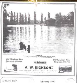
Souvenir, Complimentary A.W.Dickson Real Estate Agents calendars - 1987 and 1988.1987 calendar with photographic images of local Ringwood features and 1988 calendar featuring local Ringwood land sale promotional images from early 20th Century
... Road Ringwood North melbourne A.W.Dickson was a Real Estate Agent in Ringwood for many years. These calendars show the local buildings of the day. For example the original Eastland 's building of 1967, Maroondah Hospital 1976 and the Civic Centre now the Karralyka Centre. Photographed by C.M.S. Photographers - 725 9441 (January February 1987) RINGWOOD LAKE ...A.W.Dickson was a Real Estate Agent in Ringwood for many years. These calendars show the local buildings of the day. For example the original Eastland 's building of 1967, Maroondah Hospital 1976 and the Civic Centre now the Karralyka Centre.1 1987 calendar with six black and white photos of buildings and vistas around Ringwood with monthly dates in lower quarter of page. 2 1988 calendar with six posters advertising early 20th century land sales in Ringwood, Heathmont and Ringwood East with dates in lower quarter of page Compiled by A.W.Dickson Pty. Ltd. Real Estate Agent. Photographed by C.M.S. Photographers - 725 9441 (January February 1987) RINGWOOD LAKE - Ideal picnic spot for Ringwood Model power boats frequently on display. Barbecue area, playground, resting place for old steam engine. Yabbie netting is a favourite pastime here. (March April 1987) CLOCK TOWER - Moved from its former site on Warrandyte Road corner in 1967 and re-built in its present location, brick by brick. A wreath laying ceremony is held here on Anzac day each year. (May June 1987) RINGWOOD AQUATIC CENTRE - A world class swimming facility opened in 1986 at a cost of $3 million. Featuring the latest ozone water treatment techniques. In summer folding doors can be opened to give access to existing outdoor pools and sunbathing area. (July August 1987) MAROONDAH HOSPITAL - Opened in 1976 after many years of fund raising efforts by local people. The opening of casualty facilities was welcomed by locals as previously Box Hill Hospital catered for the entre area. (September October 1987) EASTLAND - Opened October 1967. Built on a former football oval. Now about to undergo major extensions to cater for Ringwood's population growth into the 21st Century. November December 1987 CIVIC CENTRE - Built on the site of a former antimony mine behind the council offices. Now the venue for many activities and a local point for Ringwood's Cultural Life. -
 Ringwood and District Historical Society
Photograph, Site of Loughnan's Lake, North Ringwood in April 1978
... lake shore after 1950. It also was used as a rope tree by the children. Part of a 51-photo record of the development of the "Kubis" Estate, Ringwood North, including road works to Debbie Place, Kubis Drive, Werac Drive, Iluka Place and Glenvale Road. ...Ringwood and District Historical Society 125A Warrandyte Road Ringwood North melbourne E548 N33 The leaning pine tree grew on the lake shore after 1950. It also was used as a rope tree by the children. Part of a 51-photo record of the development of the "Kubis" Estate, Ringwood North, including road works to Debbie Place, Kubis Drive, Werac Drive, Iluka Place and Glenvale Road. ...E548 N33 The leaning pine tree grew on the lake shore after 1950. It also was used as a rope tree by the children. Part of a 51-photo record of the development of the "Kubis" Estate, Ringwood North, including road works to Debbie Place, Kubis Drive, Werac Drive, Iluka Place and Glenvale Road. From the Jack Lundy Clarke collection. -
 Ringwood and District Historical Society
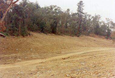
Photograph, View up the gully from Glenvale Road, North Ringwood towards the spot of the wall of Loughnan's Lake was
... Road Ringwood North melbourne The brown undergrowth is on the remains of the walls, since levelled. Circa 1979. Part of a 51-photo record of the development of the "Kubis" Estate, Ringwood North, including road works to Debbie Place, Kubis Drive, Werac Drive, Manuelo Drive, Iluka Place and Glenvale Road. From the Jack Lundy Clarke collection. View up the gully from Glenvale Road, North Ringwood towards the spot of the wall of Loughnan's Lake ...The brown undergrowth is on the remains of the walls, since levelled. Circa 1979. Part of a 51-photo record of the development of the "Kubis" Estate, Ringwood North, including road works to Debbie Place, Kubis Drive, Werac Drive, Manuelo Drive, Iluka Place and Glenvale Road. From the Jack Lundy Clarke collection. -
 Ringwood and District Historical Society
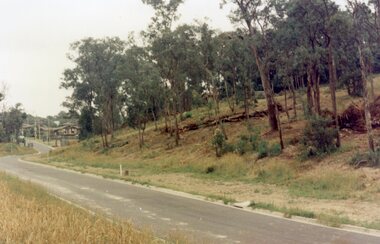
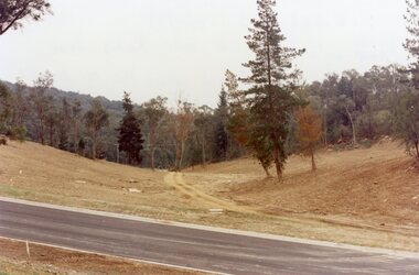
Photograph, Looking north down Werac Drive, North Ringwood with lake headwater's site behind light standard on left in February 1979
... Ringwood and District Historical Society 125A Warrandyte Road Ringwood North melbourne B552 N19 Part of a 51-photo record of the development of the "Kubis" Estate, Ringwood North, including road works to Debbie Place, Kubis Drive, Werac Drive, Manuelo Drive, Iluka Place and Glenvale Road. From the Jack Lundy Clarke collection. Looking north down Werac Drive, North Ringwood with lake ...B552 N19 Part of a 51-photo record of the development of the "Kubis" Estate, Ringwood North, including road works to Debbie Place, Kubis Drive, Werac Drive, Manuelo Drive, Iluka Place and Glenvale Road. From the Jack Lundy Clarke collection. -
 Ringwood and District Historical Society
Photograph, Site of the main body of Loughnan's Lake, North Ringwood on 10 June 1978. the rope tree was on the slope, far left
... Ringwood and District Historical Society 125A Warrandyte Road Ringwood North melbourne E550 N6 Part of a 51-photo record of the development of the "Kubis" Estate, Ringwood North, including road works to Debbie Place, Kubis Drive, Werac Drive, Manuelo Drive, Iluka Place and Glenvale Road. From the Jack Lundy Clarke collection. Site of the main body of Loughnan's Lake ...E550 N6 Part of a 51-photo record of the development of the "Kubis" Estate, Ringwood North, including road works to Debbie Place, Kubis Drive, Werac Drive, Manuelo Drive, Iluka Place and Glenvale Road. From the Jack Lundy Clarke collection. -
 Ringwood and District Historical Society
Photograph, Kubis Estate, North Ringwood in February 1978. The site of Loughnan's Lake seen from the north end of the wall. The rope tree was on the hillside on the left
... Ringwood and District Historical Society 125A Warrandyte Road Ringwood North melbourne E546 N2 Part of a 51-photo record of the development of the "Kubis" Estate, Ringwood North, including road works to Debbie Place, Kubis Drive, Werac Drive, Manuelo Drive, Iluka Place and Glenvale Road. From the Jack Lundy Clarke collection. Kubis Estate, North Ringwood in February 1978. The site of Loughnan's Lake ...E546 N2 Part of a 51-photo record of the development of the "Kubis" Estate, Ringwood North, including road works to Debbie Place, Kubis Drive, Werac Drive, Manuelo Drive, Iluka Place and Glenvale Road. From the Jack Lundy Clarke collection. -
 Ringwood and District Historical Society
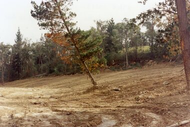
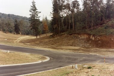
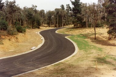
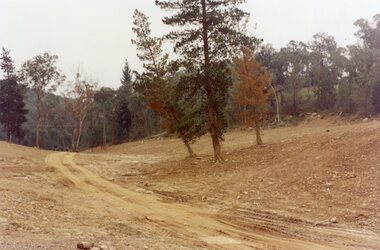
Photograph, Kubis Estate, North Ringwood in April 1978. Looking west across Kubis and Werac Drives over the full length of Loughnan's Lake site. Main pool was behind the lone pine
... Ringwood and District Historical Society 125A Warrandyte Road Ringwood North melbourne E548 N29 Part of a 51-photo record of the development of the "Kubis" Estate, Ringwood North, including road works to Debbie Place, Kubis Drive, Werac Drive, Manuelo Drive, Iluka Place and Glenvale Road. From the Jack Lundy Clarke collection. Kubis Estate, North Ringwood in April 1978. Looking west across Kubis and Werac Drives over the full length of Loughnan's Lake ...E548 N29 Part of a 51-photo record of the development of the "Kubis" Estate, Ringwood North, including road works to Debbie Place, Kubis Drive, Werac Drive, Manuelo Drive, Iluka Place and Glenvale Road. From the Jack Lundy Clarke collection. -
 Ringwood and District Historical Society
Photograph, Kubis Estate, North Ringwood in April 1978. Looking up the hill in Kubis Drive from the site of headwaters of Loughnan's Lake. Jenkins Close takes off to the right from centre
... Ringwood and District Historical Society 125A Warrandyte Road Ringwood North melbourne E548 N31 Part of a 51-photo record of the development of the "Kubis" Estate, Ringwood North, including road works to Debbie Place, Kubis Drive, Werac Drive, Manuelo Drive, Iluka Place and Glenvale Road. From the Jack Lundy Clarke collection. Kubis Estate, North Ringwood in April 1978. Looking up the hill in Kubis Drive from the site of headwaters of Loughnan's Lake ...E548 N31 Part of a 51-photo record of the development of the "Kubis" Estate, Ringwood North, including road works to Debbie Place, Kubis Drive, Werac Drive, Manuelo Drive, Iluka Place and Glenvale Road. From the Jack Lundy Clarke collection. -
 Ringwood and District Historical Society
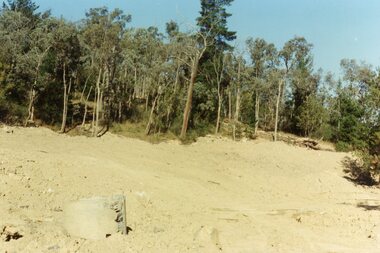
Photograph, Kubis Estate, North Ringwood in April 1978. Looking upstream from below the retaining wall of Loughnan's Lake that was where the truck tracks disappear. The wall was extended to the left across what was then a small gorge
... Ringwood and District Historical Society 125A Warrandyte Road Ringwood North melbourne E548 N19 Part of a 51-photo record of the development of the "Kubis" Estate, Ringwood North, including road works to Debbie Place, Kubis Drive, Werac Drive, Manuelo Drive, Iluka Place and Glenvale Road. From the Jack Lundy Clarke collection. Kubis Estate, North Ringwood in April 1978. Looking upstream from below the retaining wall of Loughnan's Lake ...E548 N19 Part of a 51-photo record of the development of the "Kubis" Estate, Ringwood North, including road works to Debbie Place, Kubis Drive, Werac Drive, Manuelo Drive, Iluka Place and Glenvale Road. From the Jack Lundy Clarke collection. -
 Ringwood and District Historical Society
Photograph, Kubis Estate, North Ringwood in April 1978. View of the lake site looking east. The wall was where the track bends. The rope tree was on the hillside beyond the track bend
... Road Ringwood North melbourne E548 N35 This photo was taken from almost the same spot as the 1976 one. Part of a 51-photo record of the development of the "Kubis" Estate, Ringwood North, including road works to Debbie Place, Kubis Drive, Werac Drive, Manuelo Drive, Iluka Place and Glenvale Road. From the Jack Lundy Clarke collection. Kubis Estate, North Ringwood in April 1978. View of the lake ...E548 N35 This photo was taken from almost the same spot as the 1976 one. Part of a 51-photo record of the development of the "Kubis" Estate, Ringwood North, including road works to Debbie Place, Kubis Drive, Werac Drive, Manuelo Drive, Iluka Place and Glenvale Road. From the Jack Lundy Clarke collection. -
 Ringwood and District Historical Society
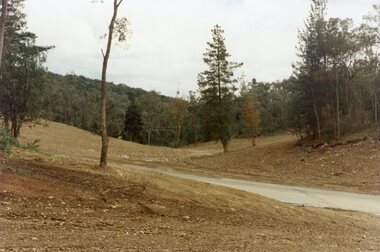
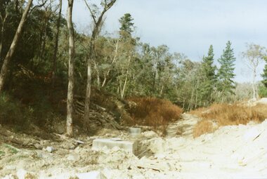
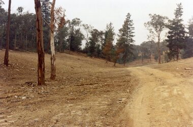
Photograph, Kubis Estate, North Ringwood in April 1978. Looking west over site of Loughnan's Lake. The rope tree was on the slope to the right beyond the ridge with the lone pine
... Ringwood and District Historical Society 125A Warrandyte Road Ringwood North melbourne E548 N15 Part of a 51-photo record of the development of the "Kubis" Estate, Ringwood North, including road works to Debbie Place, Kubis Drive, Werac Drive, Manuelo Drive, Iluka Place and Glenvale Road. From the Jack Lundy Clarke collection. Kubis Estate, North Ringwood in April 1978. Looking west over site of Loughnan's Lake ...E548 N15 Part of a 51-photo record of the development of the "Kubis" Estate, Ringwood North, including road works to Debbie Place, Kubis Drive, Werac Drive, Manuelo Drive, Iluka Place and Glenvale Road. From the Jack Lundy Clarke collection. -
 Ringwood and District Historical Society
Photograph, Loughnan Lake site over Kubis Drive, North Ringwood, on 14 April 1978. The retaining wall was where the car tracks disappear over the ridge where the spillway was
... Ringwood and District Historical Society 125A Warrandyte Road Ringwood North melbourne E548 N13 Part of a 51-photo record of the development of the "Kubis" Estate, Ringwood North, including road works to Debbie Place, Kubis Drive, Werac Drive, Manuelo Drive, Iluka Place and Glenvale Road. From the Jack Lundy Clarke collection. Loughnan Lake ...E548 N13 Part of a 51-photo record of the development of the "Kubis" Estate, Ringwood North, including road works to Debbie Place, Kubis Drive, Werac Drive, Manuelo Drive, Iluka Place and Glenvale Road. From the Jack Lundy Clarke collection. -
 Ringwood and District Historical Society
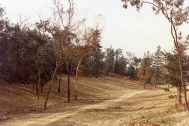
Photograph, "Kubis Estate", North Ringwood, in April 1978. Looking north-east over Loughnan's Lake greatest width. The rope tree was on the slope in the centre. The spillway was on the near left of the image
... Ringwood and District Historical Society 125A Warrandyte Road Ringwood North melbourne E548 N17 Part of a 51-photo record of the development of the "Kubis" Estate, Ringwood North, including road works to Debbie Place, Kubis Drive, Werac Drive, Manuelo Drive, Iluka Place and Glenvale Road. From the Jack Lundy Clarke collection. "Kubis Estate", North Ringwood, in April 1978. Looking north-east over Loughnan's Lake ...E548 N17 Part of a 51-photo record of the development of the "Kubis" Estate, Ringwood North, including road works to Debbie Place, Kubis Drive, Werac Drive, Manuelo Drive, Iluka Place and Glenvale Road. From the Jack Lundy Clarke collection. -
 Orbost & District Historical Society
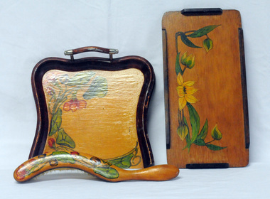
household items, 1935-1960s
... estate of Norma Adelaide Scott (nee Johnston) ,January 2, 1925 - May 18, 2018 (93 years old) who died in Orbost. Norma was part of the Morris family who came to Newmerella in 1888, had land on Grandview Road and on the flats. Mr Morris had been a school teacher at Lake...estate of Norma Adelaide Scott (nee Johnston) ,January 2, 1925 - May 18, 2018 (93 years old) who died in Orbost. Norma was part of the Morris family who came to Newmerella in 1888, had land on Grandview Road and on the flats. Mr Morris had been a school teacher at Lake ...These items are from the estate of Norma Adelaide Scott (nee Johnston) ,January 2, 1925 - May 18, 2018 (93 years old) who died in Orbost. Norma was part of the Morris family who came to Newmerella in 1888, had land on Grandview Road and on the flats. Mr Morris had been a school teacher at Lake Tyers Mission before coming to Orbost. "Bobs y’r Uncle" was a nursery rhyme game designed by Frank H. Simpson for John Waddington Ltd. in 1935. The game was especially designed for children. The cards had scenes from nursery rhymes and six cards were needed to make up each rhyme in a set. Games turned out to become an important part in the progress of Waddingtons, who eventually acquired the rights to Monopoly in the UK, and then published Cluedo, opening the way for their supremacy in the toy industry These items are examples of common household items used in an Orbost family in the first - mid 20th century.3228.1 is a wooden tray with handles. The tray is lacquered and hand - painted with green leaves and orange flowers. 3228.2 is a brush with a curved wooden handle, lacquered and decorated in a similar pattern of green leaves and flowers. 3228.3 is a small wooden tray, lacquered and hand -painted with green leaves and yellow flowers. It is a rectangular shape with raised edging attached on the four sides. 3229.4 is a pack of cards in a red box with a cartoon type drawing of a man wearing a checked coat and hat holding two dogs on leashes.3228.5 is an orange / white cardboard box containing a pair of nylon stockings: box labelled " 'KOLOTEX/ Free-n-eezy" stockings.3228,5 - in orange and white print - "KOLOTEX/ Free-n-eezy/ Clings/ 40 denier/ SEAMLESS/ S-T-R-E-T-C-H" and in black - "NEW guaranteed never to ladder"scott-norma cards-playing hosiery-kolotex-stockings trays-wooden household -
 Ringwood and District Historical Society
Photograph, Club Hotel, Mount Dandenong Road, Ringwood East in 1924, 1924
... Road, East Ringwood. The image was copied from the "Ringwood East Electric Station Estate" land sales brochure dated 1st November 1924. Refer to #5132. The hotel has a long association with the Reddish family, thus given the name of "Daisy's Hotel". Included 2 copies of the photograph. Ryman Healthcare bought the site in 2019, including the garden supply business next door, making up a 2.2ha area. The proposal was for a $220 million retirement village to be built. The location is next to Ringwood Lake...Road, East Ringwood. The image was copied from the "Ringwood East Electric Station Estate" land sales brochure dated 1st November 1924. Refer to #5132. The hotel has a long association with the Reddish family, thus given the name of "Daisy's Hotel". Included 2 copies of the photograph. Ryman Healthcare bought the site in 2019, including the garden supply business next door, making up a 2.2ha area. The proposal was for a $220 million retirement village to be built. The location is next to Ringwood Lake ...Black and white photograph of the Club Hotel on Mount Dandenong Road, East Ringwood. The image was copied from the "Ringwood East Electric Station Estate" land sales brochure dated 1st November 1924. Refer to #5132. The hotel has a long association with the Reddish family, thus given the name of "Daisy's Hotel". Included 2 copies of the photograph. Ryman Healthcare bought the site in 2019, including the garden supply business next door, making up a 2.2ha area. The proposal was for a $220 million retirement village to be built. The location is next to Ringwood Lake with the old hotel being knocked down in the early 2020s.Was item H7 in the previous numbering system. -
 Ringwood and District Historical Society
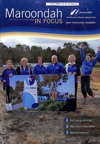
Magazine, Maroondah In Focus Council Magazine Sept-Nov 2013
... Ringwood and District Historical Society 125A Warrandyte Road Ringwood North melbourne Maroondah In Focus newsletter Sept to Nov 2013 includes features Sherbrook Park, Ringwood Library developments, Staley Gardens makeover, Costco opening preparations, Eastland transformation works with QIC Global Real Estate, Railway Station and bus interchange tenders, Ringwood Lake Park improvements. ...Maroondah In Focus newsletter Sept to Nov 2013 includes features Sherbrook Park, Ringwood Library developments, Staley Gardens makeover, Costco opening preparations, Eastland transformation works with QIC Global Real Estate, Railway Station and bus interchange tenders, Ringwood Lake Park improvements. -
 Ringwood and District Historical Society
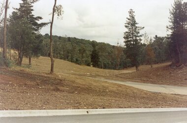
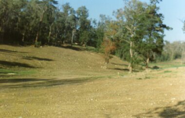
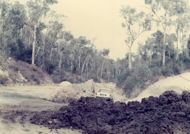
Photograph, View up Debbie Place, North Ringwood, from Kubis Drive, showing the bulldozer track from the plant-yard on the right in 1977
... Ringwood and District Historical Society 125A Warrandyte Road Ringwood North melbourne View of the southern end of the creek, above the site of Loughnan's Lake, which existed from 1911 to 1970 Part of a 101-photo record of the development of the "Bel Air" Estate, Ringwood North, including road works to Debbie Place, Kubis Drive, Jenkins Close, Burlock Avenue, Pamela Court, Manuelo Terrace, Lyn Court, Rudolf Court, Werac Drive, Iluka Place and Glenvale Road. ...Part of a 101-photo record of the development of the "Bel Air" Estate, Ringwood North, including road works to Debbie Place, Kubis Drive, Jenkins Close, Burlock Avenue, Pamela Court, Manuelo Terrace, Lyn Court, Rudolf Court, Werac Drive, Iluka Place and Glenvale Road. From the Jack Lundy Clarke collection (39 Burlock Avenue, North Ringwood) of photos taken from 1976 to 1982. The developer, Mr Kubis, named streets after his family and associates.View of the southern end of the creek, above the site of Loughnan's Lake, which existed from 1911 to 1970 -
 Ringwood and District Historical Society
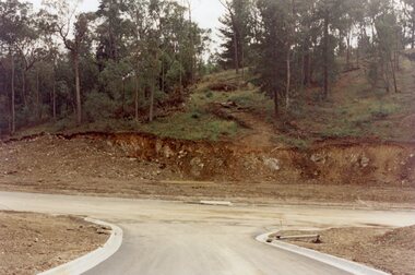
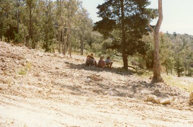
Photograph, The hillside immediately above the site of Loughnan's Lake, North Ringwood in 1977
... Ringwood and District Historical Society 125A Warrandyte Road Ringwood North melbourne Part of a 101-photo record of the development of the "Bel Air" Estate, Ringwood North, including road works to Debbie Place, Kubis Drive, Jenkins Close, Burlock Avenue, Pamela Court, Manuelo Terrace, Lyn Court, Rudolf Court, Werac Drive, Iluka Place and Glenvale Road. From the Jack Lundy Clarke collection (39 Burlock Avenue, North Ringwood) of photos taken from 1976 to 1982. The developer, Mr Kubis, named streets after his family and associates. The hillside immediately above the site of Loughnan's Lake ...Part of a 101-photo record of the development of the "Bel Air" Estate, Ringwood North, including road works to Debbie Place, Kubis Drive, Jenkins Close, Burlock Avenue, Pamela Court, Manuelo Terrace, Lyn Court, Rudolf Court, Werac Drive, Iluka Place and Glenvale Road. From the Jack Lundy Clarke collection (39 Burlock Avenue, North Ringwood) of photos taken from 1976 to 1982. The developer, Mr Kubis, named streets after his family and associates.